2020 2021 Winter Forecast Preview - Ventnor City
←
→
Page content transcription
If your browser does not render page correctly, please read the page content below
Prepared by James Sullivan,
Lead Long Range Meteorologist
Issued: August 20, 2020
Next Update: Week of Sept. 14, 2020
2020 - 2021 Winter Forecast Preview
After a remarkably mild winter, 2020 has been a year unlike any in recent memory. However, the calen-
dar is steadily marching forward, and fall is quickly approaching with winter lurking around the corner.
We are currently in the beginning stages of constructing our winter outlook, having assessed the most
likely large-scale players in the pattern. Based on this, we have formulated a general idea of what the
winter will bring. As we get closer, we will fine-tune these ideas and break down when colder, snowier
weather is more or less likely.
Part I: Preliminary Outlook for Winter 2020 - 2021
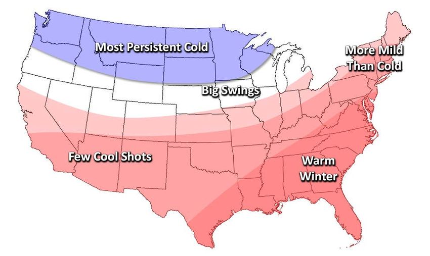
The expectation of a “La Niña”
winter (cooler waters in the Tropi-
cal Pacific), a warm Indian Ocean,
oceanic temperature patterns
in the northern Pacific, winds in
the stratosphere, and “analogs”
point to a generally mild winter
across the country. In particular,
the Southeast U.S. is expected
to be quite mild, with the most
persistent cold frequently drop-
ping into the Northwest, north-
ern Rockies, and upper Midwest.
Between the cold air poten- Expected temperature trends from December - February based
tially situated over the Pa- on early season analysis.
cific Northwest and the warmth over the Southeast, there will be a lot of ups and downs. Although
the farther southeast you go, the more likely you are to average out warmer than normal for the
winter as a whole. Does this mean there will be no cold in the Ohio Valley, Northeast, and Mid-
Atlantic? No, there will be cold periods, but they’ll likely be “outweighed” by the milder periods.
These colder periods can still bring snow, especially to the Great Lakes, Appalachians, and into
New England where average temperatures are quite cold during the winter. However, the frequent
warm-ups will likely mean many rainy or mixed events to go along with any snow, especially in the
Ohio Valley, Mid-Atlantic, and even southern New England. In La Niña winters, precipitation often
runs above average in the Ohio Valley, near to a bit above average from Upstate NY into New Eng-
land, near average in the northern Mid-Atlantic (PA, NJ), and near to drier than average farther south.
Can this forecast change? Yes; the most likely way the outlook shifts is by more “high-latitude block-
ing” occurring than what is currently expected. This blocking can buckle the jet stream and allow cold-
er weather to push south more frequently. While we can get a feel on whether blocking will be more or
less likely heading into the winter, it is better predicted at shorter time scales. So, for those hoping for
a colder, snowier outcome, it is too early to truly rule it out. We will continue to monitor for any trends
in blocking potential as winter approaches.
Page 1 www.weatherworksinc.com
www.weatherworksinc.com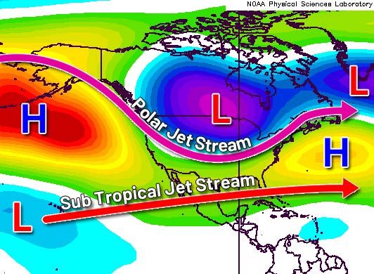
WeatherWorks 2020 - 2021 Winter Forecast Preview
Part II: Current Ocean Conditions
Sea surface temperatures are always a good place
to start in seasonal outlooks; they change much
slower than air temperatures, and can develop into
well-defined patterns that we can compare to pre-
vious years (called “analogs”). They also drive tropi-
cal thunderstorms that influence the jet stream
(and the global weather pattern).
Region 1 is the Tropical Pacific. The cooler wa-
ters in this region represent a developing La
Niña that’s expected to be in place this winter.
Region 2 is the Indian Ocean and western Pacific. Current oceanic temperature departures. Blue =
This region is rather warm right now, which focuses colder than avg. Yellow/Red = warmer than avg.
persistent clusters of thunderstorms. Whether thunderstorms stay positioned in this region through
the winter or occasionally work east towards the International Dateline may have a lot to say about how
often the U. S. sees colder intrusions east of the Rockies.
Region 3 is the North Pacific, where there is a neutral signal. Whether warmer waters end up focused
closer to Asia or North America can help determine how often cold air spills into the eastern U.S. Warm-
er waters closer to the West Coast would point to increased “colder risks” in the central and eastern U.S.
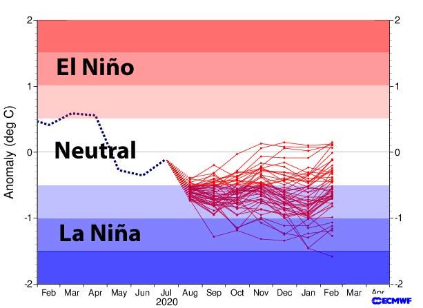
Part III: El Niño, La Niña, or Neutral?
Last winter featured borderline “warm-
neutral” to “weak El Niño” conditions, with
waters somewhat warmer than average
across the Tropical Pacific. A weak La
Niña is expected to develop by this win-
ter, with some potential to reach moder-
ate La Niña status. In general, La Niña
winters tend to feature more cold air over
the northwestern U.S. and milder weather
over the Southeast U.S. However, exactly
how strong the La Niña gets and where
the coolest waters are focused will deter-
mine how persistent this pattern will be
this winter (cooler waters focused closer to
South America may increase the potential
Projected status of El Niño and La Niña into the for colder intrusions east of the Rockies).
winter of 2020 - 2021. Courtesy ECMWF.
www.weatherworksinc.com
Page 2 www.weatherworksinc.com
WeatherWorks 2020 - 2021 Winter Forecast Preview
                      Part IV: An Early Look at Analogs
One of our most powerful long range
forecast tools is actually the past.
We can look at years with similar
large-scale patterns to what we’re
seeing this year (from the ocean, to
the lower atmosphere, all the way
through the stratosphere), and see
what pattern resulted in the winter.
The analogs point towards a ridge in
the jet stream off of the West Coast,
towards Alaska, and the Aleutian
Islands (shown by the oranges and
reds). A resultant dip in the jet stream
(called a trough and depicted in blues
and purples) is shown over western
and central Canada, which leaks into
the northern U.S. This results in a
“Southeast Ridge” cropping up along         The weather pattern for the winter of 2020 - 2021 based on
the East Coast, which typically cre-       analogous years. The average placement of the jet stream and
ates mild conditions over the eastern                 high/low pressure systems are shown.
U.S. in winter. There often is a weaker
than normal sub-tropical jet stream in our analogs.    ends up more firmly focused closer to the West
                                                       Coast and into Alaska (as opposed to farther off
While this pattern isn’t very encouraging for East     the coast), it can send cold intrusions farther
Coast snow lovers, especially outside of the north-    southeast and push back the Southeast Ridge.
ern tier from NY to New England, the implied cold      The most likely way for this to occur is for the La
intrusions and clash of air masses can result in an    Niña to remain weaker, and for thunderstorms
active pattern over parts of the Midwest and Great     to work east towards the International Dateline
Lakes. For those farther east hoping for a colder,     more frequently; we will watch for any sign of this
snowier winter, the main area to watch is the West     over the upcoming months.
Coast of North America into Alaska. If the ridge

      Protect your business from
      winter weather extremes and
      year to year variability. Weath-
      erWorks Snowtistics™ reports
      allow you to adjust your billing
      model, competitively price your
      contracts, bid for new jobs, and yield higher profits. Whether its 5, 10, 15, 30-year averag-
      es, rolling averages, median snowfall, or standard deviation, our zip code resolution data
      is backed by 34 years of reliability and accuracy from our professional meteorologists.

      For more information, visit us at www.weatherworksinc.com. Place a request for pricing and
      a Snowtistics™ report from our climatology department at: data@weatherworksinc.com.

                                                  Page 3                      www.weatherworksinc.com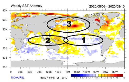

You can also read