2020 CORRIDOR TRIGGERING REPORT Delaware Department of Transportation
←
→
Page content transcription
If your browser does not render page correctly, please read the page content below
2020 C ORRIDOR
  M O N I TO R I N G
        AND
T RIGGERING          R E P O RT
                           June 2021

               New
              Castle
              County
               1673
              e l a w ar
                     e
              D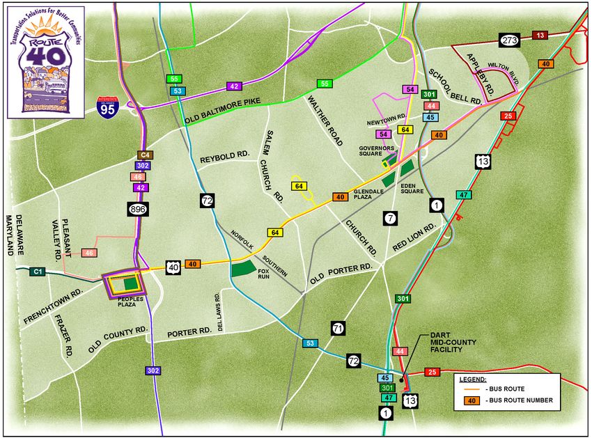
ROUTE 40 CORRIDOR IMPROVEMENTS
                                                                                                             2020 Corridor Monitoring and Triggering Report

TABLE OF CONTENTS
Introduction ...................................................................................................................................................................1

Monitoring .....................................................................................................................................................................2
 Land Development .................................................................................................................................................... 2
 Traffic ........................................................................................................................................................................7
 Highway Safety .......................................................................................................................................................10
 Transit Service .........................................................................................................................................................13
 Project Status ...........................................................................................................................................................14
 Other Projects in the Corridor..................................................................................................................................14
 Other Projects in the Region ....................................................................................................................................15

Triggering ....................................................................................................................................................................17
  Assessment of Monitored Conditions ...................................................................................................................... 17
  Recommendations ...................................................................................................................................................17

Public Involvement ......................................................................................................................................................17
  Activities During 2020 ............................................................................................................................................17
  Activities Planned For 2021 ....................................................................................................................................18

FIGURES
   Figure 1. Active Major Development Plans/Rezonings ............................................................................................. 3
   Figure 2. Developer Contributions ......................................................................................................................... 5-6
   Figure 3. Traffic Growth along US 40 (average of five count locations)................................................................... 8
   Figure 4. Transit Route Map ....................................................................................................................................13
   Figure 5. Project Status ............................................................................................................................................16

TABLES
   Table 1. Major Development Plans/Rezonings Received and/or Reviewed During 2020 ......................................... 2
   Table 2. Average Daily Traffic ..................................................................................................................................8
   Table 3. Signalized Intersection Level of Service Summary ..................................................................................... 9
   Table 4. Intersection Crash Data Summary .............................................................................................................12

CONTACTS
Wilmington Area Planning Council                                                               Delaware Department of Transportation
Dan Blevins                                                                                    Breanna Kovach, PE
100 Discovery Boulevard, #800                                                                  800 Bay Road
Newark, Delaware 19713                                                                         Dover, Delaware 19901
dblevins@wilmapco.org                                                                          breanna.kovach@delaware.gov

New Castle County Department of Land Use                                                       Delaware Transit Corporation
Owen Robatino                                                                                  Jared Kauffman
87 Reads Way                                                                                   119 Lower Beech Street, Suite 100
New Castle, Delaware 19720                                                                     Wilmington, Delaware 19805-4440
owen.robatino@newcastlede.gov                                                                  jared.kauffman@delaware.gov

                                                                                                                                                                        Page i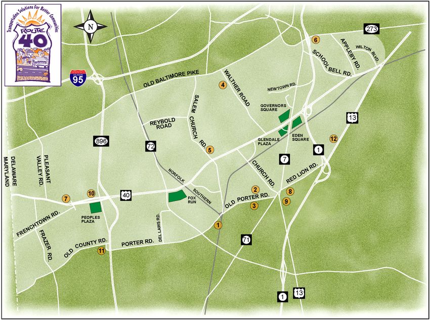
ROUTE 40 CORRIDOR IMPROVEMENTS
                                                                             2020 Corridor Monitoring and Triggering Report

INTRODUCTION                                                           •   Corridor preservation
                                                                       •   Highway safety
The Route 40 Corridor Improvements Project was initiated               •   Transit service
by the Delaware Department of Transportation in                        •   Project status
partnership with New Castle County and WILMAPCO in
September 1998. Completion of the first four steps of this             •   Impact of completed projects
project produced a community-supported 20-year                         •   Other projects in the region
transportation plan prepared under the direction of a
                                                                  Each of these factors is discussed in the following
Steering Committee composed of civic leaders, elected
                                                                sections. The project team’s assessment of these
officials, and business interests. Technical support for plan
                                                                monitored conditions forms the basis for the triggering
development was provided by a project team, composed of
                                                                section of the report. Examples of triggering, as defined in
the project partners’ staffs and their planning and
                                                                the Plan, are listed below.
engineering consultants. The Route 40 Corridor 20-Year
Transportation Plan (the Plan) was adopted on June 19,          Major land development activity would trigger immediate
2000.                                                           review of transportation needs: level of service
                                                                implications and strategy, transit service needs or
   The Plan addresses the conditions that are expected to
                                                                opportunities, safety concerns, and pedestrian and bicycle
result from projected growth in housing, employment, and
                                                                needs.
traffic over 20 years. The Plan contains projects, separated
into three phases (Phase I 2000-2007, Phase II 2008-2013,       Steady deterioration in level of service to D or worse
Phase III 2014-2020), that address projected transportation     would trigger a response in the form of strategies to
problems. By phasing projects over 20 years and using a         stabilize/reduce demand (i.e. travel demand management
monitoring and triggering mechanism, projects will be           measures or transit improvements) or increase multimodal
built only as conditions dictate, addressing one of the main    capacity.
goals of the Steering Committee.
                                                                Safety improvements recommended by the Hazard
  The fifth and final step of the project, the                  Elimination Program (HEP), a component of the Highway
implementation of the Plan recommendations. This annual         Safety Improvement Program, would trigger an evaluation
Corridor Monitoring and Triggering Report is an essential       by the project team of the compatibility of the proposed
component of this step. To assure that all projects in the      improvements with the Plan and of the need to make
Plan are implemented as conditions dictate—neither prior        adjustments to the Plan.
to the anticipated need, nor subject to unnecessary delay
after need is identified—the Plan included an                   Transit service changes proposed by DTC would trigger
implementation strategy consisting of five components:          an evaluation by the project team of any ancillary
                                                                improvements needed to complement the service changes,
    •       Corridor preservation                               such as sidewalks or shelters that should be advanced in
    •       Monitoring                                          the Plan’s implementation.
    •       Triggering                                          Transportation improvements that are not part of the Plan
                                                                but that impact the corridor and are proposed for
    •       Citizen involvement
                                                                implementation would trigger an evaluation by the project
    •       Project implementation                              team. The evaluation would focus on compatibility of the
   Citizen involvement is accomplished through a Corridor       proposed improvements with the Plan and the need to
Monitoring Committee (CMC). Until 2008, this                    make adjustments to the Plan.
committee typically met three or four times each year with        Assessment of these potential changes may trigger one
the project team to review conditions in the corridor. The      of the following options to best respond to the new
CMC met once in May 2020. Although this was the final           conditions:
year of the original Plan, WILMAPCO will continue to
support the annual monitoring efforts to guide                  Continue with a Plan project or projects as currently
transportation improvements throughout the corridor             scheduled in the WILMAPCO Transportation
beyond 2020.                                                    Improvement Program (TIP) and/or DelDOT Capital
                                                                Transportation Program (CTP).
  The monitoring efforts, which are summarized in this
report, consider:                                               Move a project(s) forward in the TIP/CTP schedule and
                                                                determine appropriate level of effort for design activities.
        •     Land development
                                                                Move a project(s) back into the out years of the TIP/CTP
        •     Traffic                                           schedule.

                                                                                                                     Page 1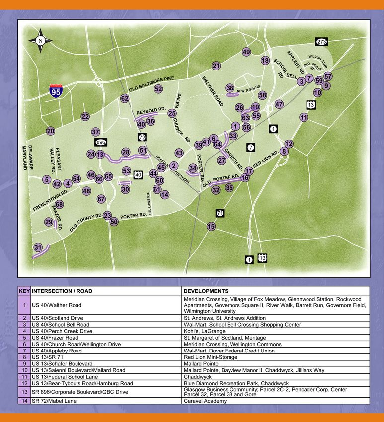
ROUTE 40 CORRIDOR IMPROVEMENTS
                                                                                    2020 Corridor Monitoring and Triggering Report

MONITORING                                                               submitted to the New Castle County Department of
                                                                         Land Use for review in the Route 40 corridor. This
                                                                         level of development activity is slightly less than 2019.
Land Development                                                         Table 1 provides a description and status of the current
The New Castle County Department of Land Use                             major development proposals and rezonings, as well
reviews development plans for compliance with the                        as other previously-submitted such plans reviewed
Unified Development Code (UDC), including                                during the year. Major development locations are
transportation aspects. The County requires review                       shown in Figure 1.
and approval of development plans by DelDOT, and                            Review of 15 major developments proposed before
review by DART when appropriate. If a major                              2020 continued this year. Among those plans, two
development plan is submitted in the corridor, the                       (The Cascades and LaGrange 10 Acre Commercial)
Route 40 Project Team may review plans for                               were recorded during 2020. Among the remaining
consistency with and impact to the Plan and provide                      thirteen plans, seven are in the record plan submittal
comments to DelDOT and New Castle County.                                stage, four are in the exploratory submittal stage, and
Summary of Development Activity                                          two expired.

During 2020, there were 19 new development plans (1
major/rezonings, 12 minor, and 6 resubdivision/other)
Table 1. Major Development Plans/Rezonings Received and/or Reviewed During 2020
           Site                                            Description                                       Remarks    New plan
                                                                                                                        in 2020?
 Vista at Red Lion        Rezone from S to ST to construct 286 age restricted townhouse units on 56.71    Record        No
 Section One              acres.                                                                          Submittal
 Vista at Red Lion        Rezone from S to ST to construct 289 single family units on 144.88 acres.       Record        No
 Section Two                                                                                              Submittal
 The Cascades             Construct an age-restricted, open spaced planned community consisting of 18     Recorded      No
                          single family detached lots, 64 village lots, and 33 lot line lots.
 LaGrange 10 Acre         Rezone from S to CR to extinguish parcel created for future pump station        Recorded      No
 Commercial               construction and cross access easement and construct a 38,579 SF retail space
                          with associated improvements.
 613 Pulaski Highway      Combine three tax parcels to develop property as a convenience store and        Expired       No
                          associated improvements.
 Crossings at Salem       Combine 4 parcels to create one parcel, rezone new parcels from NCMM to         Exploratory   No
                          CN to construct retail, office apartments, rehabilitation center with           Submittal
                          dormitories, clinical offices, nursing facility, senior living apartments,
                          community centers and recreation areas.
 Garrett Woods            Subdivide two parcels into an open space planned community consisting of        Exploratory   No
                          170 dwellings, 38 single family detached, 28 twin attached and 104              Submittal
                          townhomes with associated improvements.
 La Grange Plaza          Rezone property to construct a 6,560 SF restaurant and 11,300 SF                Record        No
                          office/retail building on 5.25 acres.                                           Submittal
 Red Lion – North         Subdivide 10-053.00-030 and 10-049.00128 into 93 single family lots.            Record        No
                                                                                                          Submittal
 Red Lion – South         Subdivide property into 87 age-restricted single family lots.                   Record        No
                                                                                                          Submittal
 Village at LaGrange      Rezone from S to ST and construct 140 apartment units, 158 manor house          Exploratory   No
                          apartments units, and a mixed-use development consisting of 66,300 SF           Submittal
                          retail, expand existing storage building for use as a restaurant, and retain
                          existing historic dwelling for office use.
 Harmony at Glasgow       Subdivide existing parcel into two lots and develop one lot into a 196,600 SF   Record        No
 Senior Living Facility   assisted living facility (181 rooms)                                            Submittal
 SAFStor DuPont           Construct three-story 103,650 GFA self-storage building                         Record        No
 Highway                                                                                                  Submittal
 Whitewood Village        Construct a 35-townhome subdivision.                                            Expired       No
 Addition
 Valley Stream Village    Amend existing parcel DPUD from Professional Office to Apartment; provide       Exploratory   No
 Apartments               two, three-story apartment buildings containing 24 total dwelling units with    Submittal
                          associated site improvements
 Porter Industrial LLC    Construct 115,200 SF of warehouses and 174 parking spaces                       Exploratory   Yes
                                                                                                          Submittal

Page 2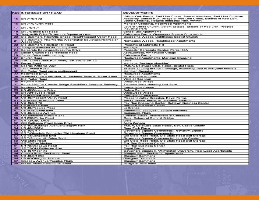
ROUTE 40 CORRIDOR IMPROVEMENTS
                                                              2020 Corridor Monitoring and Triggering Report

Figure 1. Active Major Development Plans/Rezonings
1.   Porter Industrial LLC                           7.    LaGrange Plaza
2.   Vista at Red Lion Section One                   8.    Red Lion – North
3.   Vista at Red Lion Section Two                   9.    Red Lion – South
4.   Valley Stream Village Apartments                10.   Village at LaGrange
5.   Crossings at Salem                              11.   Harmony at Glasgow
6.   Garrett Woods                                   12.   SAFStor DuPont Highway

                                                                                                     Page 3
ROUTE 40 CORRIDOR IMPROVEMENTS
                                                                  2020 Corridor Monitoring and Triggering Report

Developer Agreements                                     TIS Waivers / Fair Share Contributions
Since 2000, there have been more than 570                In 2004, New Castle County amended its Unified
applications submitted to New Castle County for          Development Code (UDC) to increase eligibility for
developments in the Route 40 Corridor. In addition to    Traffic Impact Study (TIS) Waivers. The UDC already
those previously noted, many development projects in     enabled such waivers for developments where TISs
the corridor have developer agreements with the State    had been done for changes in zoning. The modification
or County regarding transportation improvements in       allowed TIS Waivers for developments in
the corridor. These improvements range from              Transportation Improvement Districts (TIDs) or
sidewalks to widening of roadways, signal agreements     similarly defined areas where sufficient prior traffic
and significant right-of-way dedication. New Castle      studies have been done. There are currently three
County continues to work with DelDOT on a                operating TIDs in Delaware: Southern New Castle
comprehensive tracking system for these agreements,      County, Eastown, and Westown in Middletown. The
which is used to coordinate private and DelDOT-          State is also working with Kent County on the
sponsored roadway improvements. Developer                development of the US 13/Bay Road Corridor TID,
contributions throughout the corridor are highlighted    and with Sussex County on the development of the
in Figure 2.                                             Henlopen TID and Southeast Milford TID. A TIS
                                                         Waiver involving a TID is based on the traffic analysis
   Any proposed development requiring a Level of
                                                         done for the TID and its planned transportation
Service (LOS) waiver from New Castle County must
                                                         improvements, rather than a TIS, to determine what
first have a Traffic Mitigation (TM) Agreement
                                                         transportation improvements should be the developer's
negotiated with DelDOT. TM Agreements were
                                                         responsibility. The developer may still be required to
implemented to provide an alternative for developers
                                                         perform a Traffic Operational Analysis (TOA) to
to reduce trip generation and provide transportation
                                                         demonstrate DelDOT and County Level of Service
demand management measures. Developers are
                                                         (LOS) concurrency.
required to present primary and contingent trip
reduction measures that could include alternative work     There were no new applications or approvals for the
hours, preferential parking for carpools/vanpools,       TIS waivers in the Route 40 Corridor in 2020. As of
transit usage, bicycle storage, and parking              2020, 27 development plans have requested TIS
management. There are four developments in the           Waivers for locations in a TID. By the end of
Route 40 Corridor that have TM Agreements with           2020, TIS Waivers had been approved for 22 of them.
DelDOT: Lincoln Center, Springside Plaza, Astra          Two developments did not require a TIS: Reserve at
Zeneca, and Gore.                                        Becks Pond involved workforce housing, which is
                                                         exempt from County concurrence; and Lighthouse
                                                         Baptist Church where the nearby intersection had been
                                                         recently improved. DelDOT also denied a TIS Waiver
                                                         for Governors Square Commercial Center and
                                                         required a TIS for Whitewood Village. Another
                                                         development, Whittington Woods, completed a TIS
                                                         instead of completing the waiver process.

Page 4
ROUTE 40 CORRIDOR IMPROVEMENTS
                                                     2020 Corridor Monitoring and Triggering Report

Figure 2. Developer Contributions*

*Note: See legend continued on the following page.

                                                                                            Page 5
ROUTE 40 CORRIDOR IMPROVEMENTS
                                            2020 Corridor Monitoring and Triggering Report

Figure 2. Developer Contributions (cont.)

Page 6
ROUTE 40 CORRIDOR IMPROVEMENTS
                                                                     2020 Corridor Monitoring and Triggering Report

Traffic                                                     Road/Porter Road, and Walther Road.          Traffic
                                                            volumes from October 2019/2020 and March
To monitor traffic growth, 24-hour traffic counts were
                                                            2020/2021. The results indicate that the March 2021
conducted on five segments of Route 40 using
                                                            volumes near Pleasant Valley Road are close to
automatic tube counters for one week. These segment
                                                            October 2019, pre-COVID conditions.
counts were used to monitor overall trends, as opposed
to intersection counts, which were used to measure             Unsignalized intersections were not counted
levels of service. The segment counts were compared         because no improvements are included at these
with the traffic information utilized during                intersections in the Plan. It is assumed that any future
development of the Plan, which was based on counts          signalization of these intersections, whether required
conducted primarily in 1998 and 1999, as well as            due to land development or traffic growth, will have to
counts conducted for Corridor Monitoring and                meet intersection signalization warrants as required by
Triggering Reports during 2000 through 2020. As             DelDOT.
summarized in Table 2, the Average daily traffic
(ADT) volumes along Route 40 dropped significantly             The traffic volumes collected at the signalized
during 2020. This was to be expected when                   intersections were analyzed in a manner consistent
considering the impacts of the COVID-19 pandemic.           with the traffic impact study process used by New
                                                            Castle County and DelDOT. The results of the level of
  The Route 40 Plan anticipated that at the five            service (LOS) analysis are summarized in Table 3. As
locations shown in Table 2, traffic would increase by       indicated, four intersections had minor degradation in
an average of about 1.8 percent per year through 2020.      levels of service from 2019 and eight experienced
Current data indicate growth rates significantly less       slight improvements.
than what was originally anticipated (See Figure 3).
The volumes at these five locations are summarized in       • The intersection of US 40 at Pleasant Valley Road
Table 2. All five locations experienced less traffic than     improved from LOS D (35.8 sec) in 2019 to a LOS
predicted, ranging from 28.1 to 44.5 percent below the        C (31.7 sec) in 2020 during the PM peak hour.
original 2020 projections. As a result, the general         • The intersection of US 40 at Glasgow Avenue
growth trend through 2020 is about 0.5 percent                north improved from LOS E (60.0 sec) in 2019 to
annually.                                                     LOS D (46.6 sec) in 2020 during the PM peak hour.
   To compare current levels of service for                 • The intersection of US 40 at Salem Church
intersections along US 40 to the levels of service used       Road/Porter Road improved from LOS D to LOS
during the Plan development process, the project team         C during the AM peak hour. There was also an
has typically conducted intersection counts during            improvement from LOS E (57.3 sec) in 2019 to
weekday peak hours at 24 signalized intersections             LOS D (46.3 sec) in 2020 during the PM peak hour.
along US 40. Due to the effects of the pandemic, the        • The intersection of US 40 at Governors Square
project team decided to perform peak-hour turning             continued to experience LOS E during the PM peak
movement counts at four major intersections: SR 896,          hour. The primary contributing factor are the
Salem Church Rd/Porter Rd, SR 7, and US 13. The               delays associated with the side street approaches.
traffic volumes at the remaining signalized
intersections were balanced based on DelDOT ATR             • The intersection of US 40 at SR 7 improved from
locations and 2019 counts.                                    LOS D in 2019 during the AM and PM peak hours
                                                              to LOS C in 2020 during the AM and PM peak
   In addition to the peak-hour counts, traffic volumes       hours. The reduction in overall traffic volumes
from data collection stations through the DelDOT              related to the pandemic are the likely cause for the
Traffic Management Center were also reviewed.                 improved traffic operations.
These included through volumes along US 40 at three
locations near Pleasant Valley Road, Salem Church

                                                                                                             Page 7
ROUTE 40 CORRIDOR IMPROVEMENTS
                                                                         2020 Corridor Monitoring and Triggering Report

Table 2. Average Daily Traffic
                                                                                               Percentage
                                 Plan                             Projected                       under
                                                          2019                   Actual 2020                   2020
           Location            volumes     2000 counts              2020                         original
                                                         counts                   volumes                    forecast
                             (1998/1999)                          Volumes*                        2020
                                                                                                forecast

 East of Perch Creek Drive     34,000        29,000      36,506    36,725          33,527        -30.1%      48,000

 West of SR 72                 29,000        27,000      28,596    28,768          27,731        -44.5%      50,000

 West of Salem Church Road     32,000        34,000      34,301    34,507          32,500        -37.5%      52,000

 West of Walther Road          41,000        43,000      44,157    44,422          41,690        -28.1%      58,000

 West of Wilton Boulevard      27,000        27,000      24,538    24,685          23,477        -28.9%      33,000

*Based on 2019 0.6% annual growth rate

Figure 3. Traffic Growth along US 40 (average of five count locations)

Page 8
ROUTE 40 CORRIDOR IMPROVEMENTS
2020 Corridor Monitoring and Triggering Report
Table 3. Signalized Intersection Level of Service Summary
PEAK HOUR LEVEL OF SERVICE
Base 2020 without
INTERSECTION additional Plan
(1998/1999) 2000 2019 2020 improvements
AM PM AM PM AM PM AM PM AM PM
Frazer Road - - - - C C C C F C
Pleasant Valley Road2 C C C C C D C Ⓒ E F
Perch Creek Drive - - B A B B B B C C
Biddle Avenue north3 - - - - A A A A - -
Biddle Avenue south 3
- - - - B B B B - -
Peoples Plaza north B C A B A A A A A A
Peoples Plaza south B B B C A B A B C D
Glasgow Avenue north C C C C C E C Ⓓ C E
Glasgow Avenue south C D B C D D D D D D
SR 8967 D D D E D D D D F F
LaGrange Avenue - - - - B C B C B C
SR 72 D D E E D D Ⓒ D E E
Scotland Drive C B B B B C Ⓒ C C C
Becks Woods Drive4 - - - - B B B B - -
Salem Church/Porter Rd 7
C C D D D E Ⓒ Ⓓ D F
Glasgow Drive1 - - - - B B B B - -
Brookmont Drive 5
B B B B A A A Ⓑ B B
Church Road5 D C D C C C C C C C
Walther Road C D D D C D C Ⓒ C C
Governor’s Square B C C C D E Ⓒ E C D
SR 7 6,7
E D E D D D Ⓒ Ⓒ D E
Eden Square6 - - - - - - A A - -
SR 1 SB Ramps A A A A A A A A B C
SR 1 NB Ramps5 B B B A A A A Ⓑ E C
Buckley Boulevard - - B B B B B Ⓒ B C
School Bell Road B B C A B B B Ⓐ A A
Wilton Boulevard B B C C B B B B B C
US 135,7 D B C B C C C C F F
Note: Red denotes a worse level of service than 2019; green denotes improvement in level of service over 2019.
1
Traffic signal was installed at US 40 and Glasgow Drive in 2009
2
Entrance to Royal Farms (south leg) was completed in 2012
3
Traffic signal was installed at US 40 and Biddle Avenue in 2013
4
Traffic signal was installed at US 40 and Becks Woods Drive in 2013
5
These intersections were not counted during 2019; results reflect count data from 2017
Page 9ROUTE 40 CORRIDOR IMPROVEMENTS
2020 Corridor Monitoring and Triggering Report
6
Signal timing changes across the corridor were implemented in 2017 and will be finalized in 2020; part of these changes included separating the SR 7
and Eden Square signals
7
Peak hour counts were conducted at these intersections in October 2020
Highway Safety The cyclist was struck by a vehicle traveling
northbound on Wrangle Hill Road approaching the US
Each year, the project team coordinates with DelDOT
40 intersection. The cyclist was cited for failing to
Traffic Safety to request the annual crash report
obey a traffic control device.
summary for the Route 40 Corridor. In addition, to
reviewing the annual summary, the project team The first fatal pedestrian crash occurred on March
coordinates with DelDOT’s statewide Highway Safety 18, 2020 at about 8:08 PM in dark, unlit conditions.
Improvement Program (HSIP) to identify any The crash involved a pedestrian walking southerly
locations that are currently under study. DelDOT’s across the westbound lanes of US 40 within a marked
statewide HSIP includes several categories of crosswalk west of LaGrange Parkway. The pedestrian
transportation safety throughout the state. One of those was struck by a vehicle traveling westbound in the
categories is the Hazard Elimination Program (HEP), right thru lane and struck by a second vehicle traveling
which involves reviewing statewide crash rates and in the left thru lane of US 40 westbound.
selecting approximately 15 sites for study. The 2020 The second fatal pedestrian crash occurred on April
HEP list did not include any sites in the Route 40 14, 2020 at about 5:02 PM in cloudy daylight
Corridor. conditions. The crash involved a pedestrian walking
northerly across the eastbound lanes of US 40 east of
The goal of this report with respect to safety is to
the intersection at Brookmont Drive. The pedestrian
identify intersections where reported crash totals from
was hit by a vehicle traveling eastbound in the left thru
the annual summary increased significantly (>50%)
lane after they passed through the intersection. Among
compared to the previous five-year average, identify
the remaining pedestrian crashes, two occurred outside
the possible reasons for those increases, and consider
of the crosswalk, one occurred in a marked crosswalk.
those sites for detailed study and improvement
recommendations.
Route 40 Pedestrian Study
Table 4 shows the number of reported crashes
annually at selected intersections from 2015-2020. In 2017, DelDOT initiated a pedestrian safety
The 2020 crash totals were compared to the previous study along Route 40 between SR 72 and Buckley
five-year average to determine if there was an increase Boulevard. In addition to reviewing detailed crash
of greater than 50 percent. It is important to note that reports, field observations and pedestrian counts were
these totals are approximated based on raw crash data conducted at several intersections along this 4.3-mile
summaries and not the actual reports. The number of segment in spring 2017. The final study was submitted
crashes is determined based on the DelDOT mile posts in April 2019 and included a three-page matrix of
at a particular intersection along US 40 and includes short-term, mid-term, and long-term
all crashes listed within 0.10 miles of the intersection. recommendations. Some of those recommendations
These numbers may vary upon review of the detailed were implemented in 2020, including continuous
crash reports. lighting along US 40 from Salem Church Road/Porter
Road to Walther Road.
Upon reviewing the crash data, there were no
intersections where the 2020 reported crash total is Electronic Red Light Safety Program
more than 50 percent higher than the previous five- The Delaware Electronic Red Light Safety Program
year average. (ERLSP) began operations on February 1, 2004 at the
intersection of Route 13 and Webbs Lane in Dover.
Pedestrian and Bicycle Safety The program has now expanded to 46 intersections
During 2020 in the Route 40 corridor, a total of five statewide. Among those intersections there are six
reported crashes involved pedestrians and three located along US 40 as noted below.
involved bicyclists. Three of the five reported • US 40 at SR 896
pedestrian crashes resulted in personal injuries and
two resulted in a fatality. One of the three reported • US 40 at SR 72
bicyclist crashes resulted in personal injury and two • US 40 at Scotland Drive
resulted in property damage only. • US 40 at Glasgow Drive
The cyclist crash resulting in an injury was caused • US 40 at Governors Square
by the cyclist traveling eastbound on US 40 eastbound
across Wrangle Hill Road, disregarding a red signal. • US 40 at Eden Square
Page 8ROUTE 40 CORRIDOR IMPROVEMENTS
2020 Corridor Monitoring and Triggering Report
Each location is identified based on an extensive
selection process that includes reviewing crash data,
field observations, signal timing review, data
collection, and site evaluation. The program also
completes an annual report that provides statistics
about reported crashes, violations, and program
revenue and expenses.
DelDOT is currently evaluating additional locations
for enforcement along US 40. More details about the
history of the program and updates on the progress can
be reviewed on the project website at:
https://www.deldot.gov/Programs/red_light/index.sh
tml
Page 11ROUTE 40 CORRIDOR IMPROVEMENTS
2020 Corridor Monitoring and Triggering Report
Table 4. Intersection Crash Data Summary
NUMBER OF REPORTED CRASHES
INTERSECTION
2015 2016 2017 2018 2019 5-yr average 2020
Frazer Road 9 16 8 6 14 11 3
Pleasant Valley Road 25 12 27 27 19 22 14
Perch Creek Drive1 10 19 16 15 13 15 13
Peoples Plaza 12 13 9 6 6 9 11
Glasgow Avenue 17 21 30 32 27 25 21
SR 896 53 49 31 56 42 46 43
LaGrange Avenue 13 17 13 12 9 13 11
SR 725 51 42 26 36 24 36 30
Scotland Drive 29 23 20 21 15 22 19
Becks Woods Drive3 6 13 6 11 8 9 9
Salem Church/Porter Road 35 38 33 51 38 39 23
Glasgow Drive2 10 13 8 15 17 13 13
Brookmont Drive 23 16 19 23 19 20 12
Church Road 29 31 26 35 29 30 29
Walther Road 17 23 17 21 13 18 8
SR 74 49 54 47 45 52 49 55
SR 1 SB 9 13 11 17 16 13 17
SR 1 NB 7 10 10 9 9 9 4
Buckley Boulevard 8 15 8 10 9 10 9
School Bell Road 6 3 5 9 4 5 4
Wilton Boulevard 16 11 17 14 13 14 9
1A fourth leg (north) was constructed in 2010 as part of the LaGrange Development.
2A traffic signal was installed at Route 40 and Glasgow Drive in November 2009.
3
A traffic signal was installed at Route 40 and Becks Woods Drive in early 2013.
4
DelDOT Contract T201200104 – US 40 at SR 7 intersection improvements were complete in 2019.
5
DelDOT Contract T200411901 – US 40 at SR 72 intersection improvements were substantially complete in 2020.
Page 12ROUTE 40 CORRIDOR IMPROVEMENTS
2020 Corridor Monitoring and Triggering Report
Transit Service route 54 and 55 will no longer service Wilmington;
route 64 will no longer serve the Wilton Blvd Wal-
Comparing transit ridership numbers in 2020 with Mart, instead serving Christiana Mall. Additional
those from 2019, ridership in the US 40 corridor service changes scheduled for September 2021 include
fluctuated significantly. This was to be expected when straightening bus route 64 so it doesn’t deviate along
considering the impact of the COVID pandemic. Scotland Drive and Porter Road due to low ridership.
When comparing total ridership for the bus routes in This will also help accommodate the needs of riders
the Route 40 Corridor, there was a 44.9% decrease in from apartments in and around Apple Chase who were
ridership between 2019 and 2020. There was actually impacted by bus route 40 being diverted away from
a slight increase (1.6%) in ridership when only Christiana Mall.
comparing January and February ridership in 2019 and DART continues to monitor and evaluate route
2020. In fact, there was a 50% increase in ridership changes as part of the traffic mitigation efforts
for bus route 64 during that period. When comparing associated with DelDOT’s proposed I-95 Viaduct
the months of April through December, there was a rehabilitation project. These efforts include
55% decrease in ridership between 2019 and 2020. encouraging employees to work from home, shift
The greatest decrease occurred on bus route 42, which work hours, carpool, and potential route changes.
had a loss of over 80%.
Upcoming service changes scheduled for
implementation in February 2021 include diverting
bus route 42 to the SR 896 park & ride; route 40 being
routed away from the Christiana Mall - continuing
straight along US 40 and US 13 in to Wilmington;
Figure 4. Transit Route Map
Page 13ROUTE 40 CORRIDOR IMPROVEMENTS
2020 Corridor Monitoring and Triggering Report
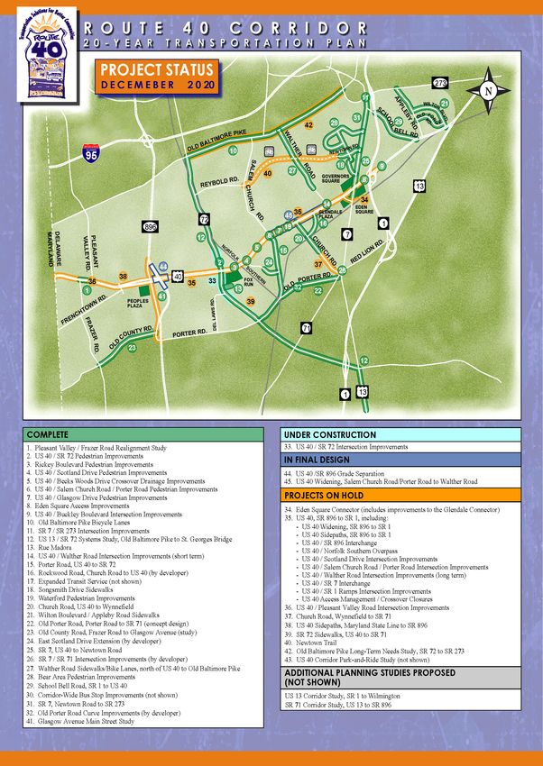
Project Status alternative was selected in 2018. Preliminary design
began in early 2019 and semi-final plans are schedule
During 2020, there were three active projects in the to be complete in late 2020. A second public workshop
corridor that were part of the original Plan: US 40 at was conducted in September 2020.
SR 72 intersection improvements, US 40 widening
from Salem Church Road/Porter Road to Walther Glasgow Avenue Main Street Study
Road, and the US 40/SR 896 interchange. Figure 5
The Glasgow Avenue Main Street Study was
shows the status of Plan projects in the corridor as of
completed in 2017. The study was undertaken to
the end of 2020. Detailed descriptions of all active
develop a vision plan that will guide future
projects are provided below.
transportation and land use along Glasgow Avenue in
an effort to become a functional “Main Street” for the
US 40 at SR 72
surrounding community.
This project includes the addition of a through lane
The study provided several recommendations
along northbound and southbound SR 72 to provide
related to character districts, proposed gateway
adequate storage and taper lengths and the addition of
treatments, complete streets, and development. The
left-turn lanes along eastbound and westbound US 40.
study is now in the implementation phase when
Del Laws Road will be realigned to reduce the existing
DelDOT, WILMAPCO, and New Castle County will
skew and align it with the future proposed access to
use the design guidelines provided in the study to
the Fox Run Business Center; a traffic signal will also
achieve the Main Street vision. Design funding for
be installed at the intersection. Pedestrian and bicycle
improvements along Glasgow Avenue, SR 896 to US
facilities will also be constructed.
40 is scheduled for FY 2022 and construction funding
Final design and right of way acquisition were is scheduled for FY 2026.
completed in 2017. Advance utility relocations began
A copy of the study is posted on the WILMAPCO
in early 2018 and construction began in spring 2018.
website at:
Construction was substantially complete in 2020.
There are some minor items that remain to be www.wilmapco.org/Glasgow/GlasgowAveMainStree
completed. As part of this contract, DelDOT will be tStudy.pdf
extending the paving limits about 1.4 miles south of
Del Laws Road down to the railroad crossing. The
additional paving work should begin in summer 2021. Other Projects in the Corridor
US 40 Widening, Salem Church Road/Porter Old Baltimore Pike at Salem Church Road
Road to Walther Road This project was originally identified as part of the
The US 40 widening from Salem Church Road/Porter 2009 HEP. The interim improvements include
Road to Walther Road began concept design in 2016. restriping Old Baltimore Pike to increase the storage
In 2018, the developer for Rockwood completed of the left-turn lanes at the approaches to Salem
widening to add a through lane along eastbound Route Church Road (east) / Salem Woods Drive and Salem
40 from Rockwood Road to Glendale Boulevard. Church Road (west).
Environmental documents and final design for the The short-term improvements were added to a
remaining segment west of Rockwood Road began in pavement and rehabilitation project along Old
2018. A virtual public workshop was conducted in Baltimore Pike. The limits extend from SR 72 to
May 2020 and a follow-up workshop was conducted Salem Church Road. Construction began in fall 2020
with the Raven Glan Community in September 2020. and is scheduled to be complete in the summer of
Construction is anticipated to begin in spring 2023. 2021. The long-term improvements for this
intersection are at the early stages of project
US 40 at SR 896 Intersection development.
Project development to address safety and congestion US 40 Pavement Rehabilitation
issues began in 2016. The project team developed
concept alternatives, three of which were retained for This project includes pavement reconstruction and
further analysis and were presented at a public resurfacing from SR 72 to US 13. Construction began
workshop held on May 1, 2018. A preferred in fall 2020 and is scheduled to be complete in summer
2021.
Page 14ROUTE 40 CORRIDOR IMPROVEMENTS
2020 Corridor Monitoring and Triggering Report
SR 72 Pavement Rehabilitation Roadway construction is scheduled to be complete in
2024.
This project was added to the US 40 at SR 72
intersection improvements. It includes additional I-95 at SR 896 Interchange
pavement reconstruction and resurfacing south of Del
Design began in 2018. The project was advertised in
Laws Road to the railroad crossing. The project is
November 2020 using alternative contract
scheduled to begin construction in fall 2021.
Construction Manager/General Contractor (CM/GC)
delivery. This approach allows the Department to
US 13 Paving and Pedestrian Improvements,
solicit a contactor to become part of the project team
Llangollen Blvd to Bacon/Boulden Blvd
during final design, offering input about the design to
This project includes pavement resurfacing, 2.8 miles improve constructability and mitigate risk. Bids are
of new sidewalk, corridor lighting improvements and due February 9, 2021 and a public workshop is
new traffic signal with a signalized pedestrian crossing scheduled for February 16, 2021. Construction is
at Quigley Boulevard. Final design is underway, and scheduled to begin in 2022.
construction is expected to begin in late 2022.
Other Projects in the Region
As noted in previous Corridor Monitoring and
Triggering Reports, future regional projects may have
an impact on the Route 40 corridor. The status of these
projects is summarized below.
SR 1 widening, Road A to US 13/Tybouts Corner
Planning has begun for widening (from four to six
lanes) and pavement reconstruction along this segment
of SR 1. The project will be split into two contracts,
one from Road A to Route 40 and a second from Route
40 to US 13/Tybouts Corner. The first contract will
also include improvements to the SR 1 at SR 273
interchange. A virtual public workshop was
conducted in November 2020 to review project status
and present build alternatives. The plan is to select a
preferred alternative in early 2021 and submit the
environmental documents for review in summer 2021.
SR 72, McCoy Road to SR 71
This project proposes to widen SR 72 from two to four
lanes between McCoy Road and SR 71. Multimodal
improvements, including shoulders to accommodate
bicycles and new sidewalks are also planned. Utility
relocation and drainage construction began in spring
2019 and the roadway widening is anticipated to begin
in spring 2022 once the utility contract is complete.
Page 15ROUTE 40 CORRIDOR IMPROVEMENTS
2020 Corridor Monitoring and Triggering Report
Figure 5. Project Status
Page 16ROUTE 40 CORRIDOR IMPROVEMENTS
2020 Corridor Monitoring and Triggering Report
TRIGGERING Continue to review annual crash reports to identify
crash patterns or changes in the corridor.
Assessment of Monitored Conditions Transit
Traffic congestion did not change substantially in Identify existing bus stops where improvements are
2020. Levels of service were acceptable for all needed – damaged shelters, need for lighting, access
intersections that were counted in 2020 except for and sidewalk reconstruction.
Governor’s Square. Traffic data confirms that overall
Continue to track ridership in the corridor and provide
growth rates are still significantly lower than
service enhancements where appropriate.
originally anticipated by the Plan. In addition, the
COVID-19 pandemic was a major factor in decreased Continue to identify opportunities for developer-
traffic volumes during 2020. funded transit improvements such as bus service
During 2020, there were 19 new development plans expansion, bus stop improvements, transit oriented
submitted to New Castle County for review in the development, and innovative trail projects throughout
Route 40 corridor. Review of 16 major developments the Route 40 Corridor.
proposed before 2020 continued this year. Among Planning, design, and construction
those plans, two were recorded in 2020.
Complete construction for the US 40 / SR 72
There were not sites included on the 2020 HEP list intersection improvements
and no intersections with significant increases in
reported crashes. There were two pedestrian fatalities Continue final design for the US 40 widening between
and two vehicular fatalities reported in the corridor in Salem Church Road/Porter Road and Walther Road
2020. Continue final design for the US 40 / SR 896 Grade
Bus ridership decreased by about 55% between Separated Intersection
April and December 2020 when compared to the same Complete pavement and rehabilitation projects along
period in 2019. This was primarily due to the COVID- US 40 and SR 72
19 pandemic.
Evaluate need and program funding for US 40 at SR 7
grade separation and Eden Square Connector.
Recommendations
General
Continue to identify funding sources to implement as
PUBLIC INVOLVEMENT
many of the recommendations below as possible and
restore projects that have been placed on hold. Activities During 2020
Land development The CMC met in May 2020 and there were virtual
public workshops for the Route 40 Widening and US
Continue to monitor development activity to ensure 40 at SR 896 interchange projects. There were no
compatibility with the Plan and maintain consistent other public involvement initiatives for the Route 40
developer contributions to transportation corridor during 2020 due to funding constraints.
improvements.
The project website, which was reformatted in 2018
Monitor developer agreements for major land to match the current DelDOT standard, is updated
developments to ensure the compatibility of annually to provide the latest information on
developer-sponsored improvements with the Plan. implementation of the Plan.
Corridor preservation
The site contains information from newsletters,
Continue pursuing corridor preservation opportunities updates on project planning, design, and construction,
through the site review team process. and a schedule of public meetings and workshops. The
Highway safety site can be accessed from the DelDOT Web site at:
https://deldot.gov/projects/
Continue to follow pedestrian safety improvement
implemented as part of the Route 40 Ped Safety Study. Search: US 40 Corridor
Page 17ROUTE 40 CORRIDOR IMPROVEMENTS
2020 Corridor Monitoring and Triggering Report
Activities Planned For 2021
To ensure the community is kept up to date and
involved in the progress of transportation
improvements in the Route 40 corridor, the project
team will continue the following communications
initiatives for 2021:
Website - The Route 40 corridor project website will
continue to be maintained and updated on a regular
basis.
E-mail, project mailing address and telephone
hotline - Residents will still be able to communicate
with the project team through various channels—
email, mailing address, or telephone.
Page 181 0 1 3 CEN TR E ROA D, SUI TE 302
Whitman, Requardt & Associates, LLP W ILM INGTON, DELAWARE 19805
Engineers Achitects Environmental Planners Est. 1915 3 0 2 -5 7 1 -9 0 0 1
W R A LLP.COMYou can also read