2021-2025 Delaware Wetland Program Plan - A guidance for building a State of Delaware comprehensive wetland program - EPA
←
→
Page content transcription
If your browser does not render page correctly, please read the page content below
2021-2025
Delaware Wetland
Program Plan
A guidance for building a State of Delaware comprehensive
wetland program.
Overview
The Delaware Wetland Program Plan was developed by the Delaware
Department of Natural Resources and Environmental Control’s
Wetland Monitoring and Assessment Program. This effort was
supported by a Region 3 Wetland Program Development Grant
awarded by the U.S. Environmental
Protection Agency (EPA).
Projects described in this document were/are funded by the U.S. EPA
under the following assistance agreements: CD-96347201,
CD-96330901, CD-96362201, and CD-96383101. The contents of
this document do not necessarily reflect the views and policies of the
U.S. EPA, nor does the EPA endorse trade names or recommend the
use of commercial products mentioned in this document.
Authors:
Alison Rogerson
Erin Dorset
Kenny Smith
Mark Biddle
Designer:
Brittany Haywood
Photographers:
Chris Bason
William McAvoy
Wetland Monitoring and Assessment
Program (WMAP)
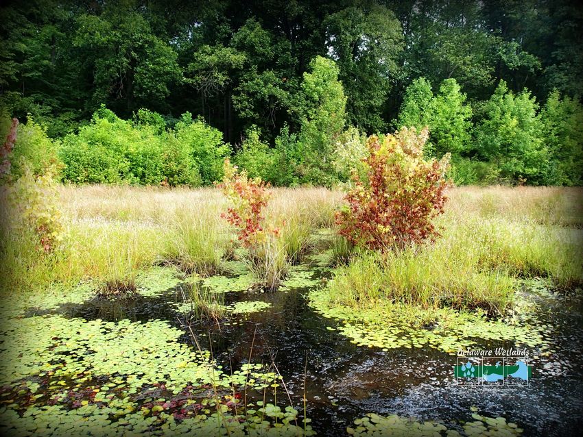
Cover photo: Groundwater seep wet meadow (Bill McAvoy)
Cover photo insets: (left to right) flooded forest, water plant, red-spotted newt eft,
salt marsh in Inland Bays, American strawberry bush flower (WMAP)
Back Cover: Foggy morning on the Appoquinimink River, Odessa (WMAP)
Recommended Citation: Delaware Department of Natural Resources and
Environmental Control. 2020. 2021-2025 Delaware Wetland Program Plan. Dover,
Delaware, USA. 31pp.
Page i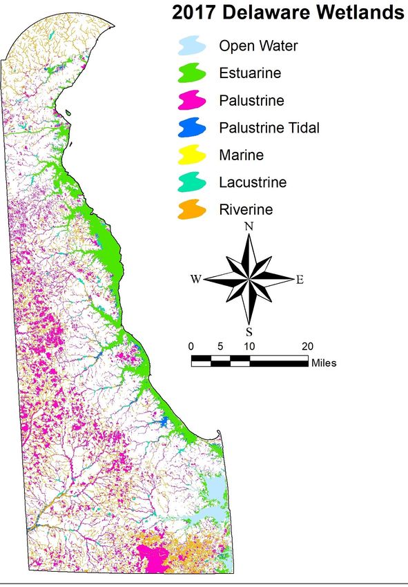
TABLE OF CONTENTS

Introduction                                           .…………………….                1
Wetland Monitoring & Assessment Program                …….……………….                2
Objective 1: Monitoring & Assessment                   …………………….                 6

         Goal A: Mapping                               …………………….                8
            UPDATE WETLAND MAPPING TOOLS AND IMPROVE ACCESS TO WETLAND
            RELATED SPATIAL DATA

         Goal B: Monitoring                            …………………….                10
            INCREASE MONITORING EFFICIENCY AND EFFORT TO PROVIDE INSIGHT INTO
            WETLAND FUNCTION AND HEALTH

         Goal C: Climate Adaptation                    …………………….                12
            USE AVAILABLE SCIENCE AND RESEARCH TO BETTER UNDERSTAND AND PLAN
            FOR THE EFFECTS OF CLIMATE CHANGE AND SEA LEVEL RISE ON
            WETLAND HABITATS
         Objective 1: 5 Year Schedule                 …………………….                 14
Objective 2: Voluntary Restoration & Protection       …………………….             15
         Goal D: Restoration                          …………………….             16
            ADVANCE WETLAND RESTORATION, CREATION AND ENHANCEMENT TO
            INCREASE WETLAND ACREAGE, CONDITION AND FUNCTION
         Objective 2: 5 Year Schedule                 …………………….                 18

Objective 3: Education & Collaboration                …………………….             19
         Goal E: Collaboration                         ……………….…….               20
            FACILITATE COLLABORATION AND PROJECT SHARING AMONG WETLAND
            SCIENCE PROGRAMS, EDUCATORS AND REGULATORS

         Goal F: Education                             …………………….            22
           ENHANCE EDUCATION AND OUTREACH EFFORTS TO BROADEN
           UNDERSTANDING AND STRENGTHEN WETLAND STEWARDSHIP AMONG ALL
           WETLAND STAKEHOLDERS

         Objective 3: 5 Year Schedule                 …………………….                 24

Objective 4: Regulation                                …………………….                25
         Goal G: Conservation                          …………………….            26
            WORK WITH PARTNERS TO SUPPORT AND ENHANCE WETLAND
            CONSERVATION PROGRAMS THAT ARE NOT COVERED BY STATE OR
            FEDERAL REGULATIONS

         Objective 4: 5 Year Schedule                    …….…………….          28
Evaluating Progress                                       ..………………… 29
Literature Cited                                          .…………………. 30
Appendix A: Acronym Glossary                             ……………………. 31

                                  Page ii
INTRODUCTION
                                          Delaware is host to approximately 296,350 acres of wetlands (Figure 1) that
                                          vary in salinity, soil type, and vegetation based on geographic location and
                                          water source. With roughly one quarter of the state’s land area being
                                          wetlands, citizens and visitors to Delaware are surrounded by these hard-
                                          working natural features. Situated between water and land, wetlands are
                                          highly adapted to particular conditions and provide many important services
                                          that support the state’s economy (Figure 2). Wetlands are home to a
                                          myriad of plant and wildlife species, some rare and endemic species, as well
                                          as commercially harvested species. Delaware benefits from a strong
                                          tourism industry which includes birders, hunters, and nature enthusiasts
                                          who visit Delaware and support local businesses. Wetlands also have the
                                          capacity to filter pollutants from our drinking, fishing, and swimming waters
                                          and protect our shorelines and property from damaging winds and floods.
                                          Our bountiful wetland resources play an understated but vital role for our
                                          communities, economy and well-being.

                                            However, Delaware’s beautiful and valuable wetland resources are still
                                            vulnerable to the same threats they have faced for the past 20 years, such as
                                            conversion to agriculture or development, a lack of awareness or
                                            appreciation, and prioritization differences among management levels.
Figure 1. Wetland types in Delaware based Other challenges are becoming more prominent, such as conversion to open
on 2017 wetland maps.                      water and salt water intrusion due to sea level rise and climate change.
                                           Wetlands in the Mid-Atlantic region, in particular, face severe impacts due to
a heightened local rate of sea level rise and require the space and opportunity to migrate landward. The intention of
this program plan is to outline how to address some or all of those threats in the next five years (2021-2025) in
cooperation with partners through the goals and action items listed.

A healthy network of groups around the state are dedicated to studying, protecting, and improving wetlands for today
and future generations. This network ranges from state, county, federal, private, non-profit, and academic groups, and
often their work overlaps. In 2015, DNREC and many partners collaborated to update a guiding document comprised
of 45 action items that identified and prioritized areas where information or action was needed. Over the past 5 years,
progress has been made on 71% of the proposed action items, with 20 of them completed and another 12 in progress.
Specifically, monitoring and assessment, voluntary restoration and protection, and education and collaboration
objectives have all advanced substantially, but more work needs to be done to address the regulation objective.
Today, updated goals and action items in the 2021-2025
Delaware Wetland Program Plan address remaining gaps
and needs to improve Delaware’s capacity to monitor,
restore, regulate, and conserve its wetland resources.

In preparation for this program plan the following related
documents were reviewed to identify overlapping
objectives: Delaware Wildlife Action Plan 2015-2025,
2020 Delaware Statewide Forest Strategy, Delaware
Estuary CCMP 2019 Revision, the Center for the Inland
Bays 2020 CCMP, and the 2020 Delaware Climate Action
Plan. The contents of this document categorize and
identify existing or recently developed areas of need as
they related to wetland science, conservation and
management.

DNREC’s Wetland Monitoring and Assessment Program
(WMAP) will use the goals and action items listed here
                                                       Figure 2. Wetland Functions and Societal Values
to prioritize and select future projects to strengthen
Delaware’s capacity to conserve and improve wetlands.
                                                        Page 1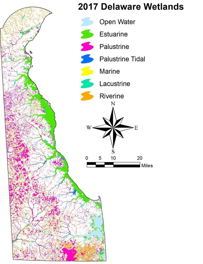
Wetland Monitoring & Assessment Program
Vision: To achieve an annual net gain in wetland acreage and condition to
support the wealth of services and functions wetlands provide
The objectives of the WMAP which will achieve our vision are:
Objective1: Monitoring & Assessment —Obtain up-to-date scientifically valid information on the status and
trends (quantity, quality, functions and services) of wetlands to make wise management decisions.
Objective 2: Voluntary Restoration & Protection —Protect and restore wetlands through a variety of
tools including voluntary incentive programs, and integration with watershed strategies and conservation plans.
Objective 3: Education & Collaboration —Inform the citizens and visitors of Delaware about the functions
and services of wetlands. Collaborate with State programs and conservation partners to improve project
efficiency and effectiveness.
Objective 4: Regulation — Inform regulatory decisions, mitigation processes and report to the Clean
Water Act.
Objective 1 is a direct product of the ongoing efforts to monitor and assess the condition, function, and services of
wetlands in the state. Objective 2 applies the information generated from Objective 1 to positively affect the
decisions being made about the management, restoration, and protection of wetlands. Objective 3 transfers the
knowledge and perspectives gained from Objective 1 and 2 to bring awareness and appreciation for wetlands.
Objective 4 receives input from objectives 1, 2 and 3 to provide accurate and effective information to inform
regulatory decisions and mitigation processes. The product of all four objectives will lead to the protection and
restoration of wetlands and an increase in wetland acreage, function and services (Figure 2).
Wetland Monitoring & Assessment Program Objectives
Figure 2. The four objectives of the program (shown in rectangles) needed to achieve the WMAP program
vision (shown in circle).
Page 2
The WMAP uses assessment protocols to determine the quality of Delaware’s wetlands and measure the
functions and ecological services that they are providing. However, to develop a comprehensive strategy from
site selection to data analysis and interpretation, various other factors must be considered. The following is an
overview of the components of a wetland monitoring and assessment program as outlined in the EPA document
“Application of Elements of State Water Monitoring and Assessment Program (2006).

Wetland Management Plan
The WMAP operates under the Delaware Wetland Management Plan which is an update of the Delaware
Wetland Conservation Strategy. The Management Plan was produced using the input of a core team of 15
professionals representing six DNREC divisions and the Delaware Forest Service. Based on the
accomplishments since 2008 and the existing gaps and
needs of multiple wetland programs in the state, 7 major
goals are identified accompanied by 39 related action
items. This 5-year plan is intended to be a guiding
document for DNREC and its partners to identify and
prioritize wetland program needs, and to encourage
collaboration and efficiency to improve Delaware’s
capacity to conserve and improve its wetland resources.

Survey Design
The WMAP involves two levels of survey design. The first
is to prioritize the order in which watersheds in the state
will be monitored and the second is to define how we will
select sampling locations within a watershed.
Prioritization of Watersheds
Prioritization of watershed monitoring efforts will be
based largely on the TMDL implementation schedule. By
following this schedule, comprehensive information about
the surface waters and wetlands can be combined to
develop the best restoration strategy for each watershed.
Figure 3 depicts a tentative schedule for future wetland
monitoring and reporting efforts. The dates will depend
on the availability of resources at the State level and
development of appropriate methods. The intent of the
State is to monitor these watersheds using a rotating basin
approach once an initial assessment of the wetlands within
each watershed has been performed.
Watershed Sampling Design
The approach used to select sampling locations within a
watershed will be a probabilistic sampling design. We
currently rely on technical support from EPA’s Ecological
Monitoring and Assessment Program (EMAP) to randomly
select sampling sites within mapped wetlands in a
watershed. The WMAP supplies the base map and any
additional criteria such as excluding manmade ponds or
only including tidal or non-tidal wetlands. Currently EPA is
working on developing a program that would allow states
to perform this operation independently. The base map
that will be used for all watersheds will be the most up-to-
date wetland layer available.                                  Figure 3. State of Delaware Wetland Monitoring Schedule

                                                      Page 3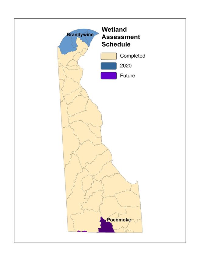
Assessment Indicators & Methods
The State of Delaware is
developing multiple levels
of assessment methods to
evaluate wetland condition.
These levels include a
landscape level remote
sensing, ground truthing
through rapid field
assessment, intensive field
assessment, and fixed
monitoring stations (Figure
4) and are described in the
Protocol Development
section. With increasing
data complexity the
sampling scale becomes
smaller. These data will be
used in combination as
resources and needs arise.
For example, statewide
wetland censuses are
updated every decade         Figure 4. Four tiered approach to wetland assessment. The level of information and amount of
where as fixed monitoring effort increases from regional to site specific. Each level overlaps with the next, allowing
                             feedback, refinement and validation. (credit: PDE)
stations are sampled
annually. Ground truthing with rapid assessments occurs on a rotating watershed basis and intensive studies are
incorporated occasionally. Assessment data from all levels will continue to be used to test for correlations
between levels and refine protocols to improve the accuracy and the sensitivity to varying wetland condition.

Field Data Collection
Based on past experience, it is essential to have a full time field coordinator who is responsible for implementing
the monitoring in a watershed. This person should be dedicated full time to this task to effectively manage the
large amount of information and oversee the multitude of tasks needed to accomplish the ambitious sampling
goals in each watershed. This person will work directly under the Project Manager who is a DNREC employee.
Access to private property will be essential to the success of this program. Only sites on private property for
which permission from the landowner has been granted will be sampled. In general, private landowners in
Delaware are receptive to having field crews collect data on their property that will be used to improve the
resources in their watershed. As part of every monitoring effort in a watershed, a public outreach component
will aim to disseminate program goals as well as summaries of the data that are collected and related
management implications.

Quality Assurance Program & Project Plans
The WMAP collects and manages all data under an EPA approved Quality Assurance Project Plan (QAPP). The
QAPP covers project and task organization, training, data generation and acquisition, sampling design, sampling
methods, quality control, equipment testing, data management, assessment and oversight, and data verification
and validation. A copy of the QAPP can be obtained from Delaware DNREC’s Watershed Assessment and
Management Section.

                                                         Page 4
Data Management
GIS Capabilities
The WMAP is equipped with up-to-date GIS software and will keep staff trained in using GIS programs to assist
with: planning monitoring efforts, tracking collected data spatially and analyzing wetland data. Wetland
monitoring data will be stored for future use and will be shared with DNREC for use in other related projects or
decisions.

Training
All persons involved in the data collection process will be required to complete training to properly use the
assessment protocols. One to two day training sessions will be offered by DNREC and will consist of lectures on
how to properly use the protocols, high quality data collection practices, and field training to demonstrate the
techniques. Field crew leaders will be required to have additional training consisting of participating on a field
crew to collect data until the program manager is confident that they are proficient with the techniques. While
collecting data, the current QAPP will be followed to ensure the highest quality of data.

Data Collection and Storage
All data collection will be collected and recorded using the procedures and datasheets for the Mid-Atlantic Tidal
Rapid Assessment Method (MidTRAM), the Delaware Comprehensive Assessment Procedure (DECAP),
Delaware Rapid Assessment Procedure (DERAP), and Value-Added Protocol. The current versions of both
methods and the corresponding datasheets are available online from the Delaware wetlands website (http://
de.gov/delawarewetlands) or by request. All data will be entered or transferred into an Excel computer database
that has been developed to consistently store wetland assessment data. Paper copies of the datasheets will be
stored in the Watershed Assessment and Management Section.

Data Analysis
The WMAP follows documented procedures for collecting, processing and analyzing data. Methods for
identifying random sites in each watershed are detailed in a Design Documentation report. Landowner success
and sample profiles are provided in the technical wetland condition reports. Appropriate procedures for scoring
data and ranking sites are specified in each protocol (tidal, nontidal, condition and value). For the Level III
assessment, a Variable Scoring Protocol is in place for the three dominant types of freshwater wetlands (flat,
riverine and depression wetlands) for calculating variable scores, functional scores and overall Index of Wetland
Condition values. In addition, statistical and analysis procedures for comparing level 2 tidal data to tidal marsh
bird survey data is documented in writing to be repeated in the future. Datasheets designed for each sampling
method accompany the procedures and are always used.

Project Reporting
For each watershed assessed a technical report will be produced in a timely fashion that summarizes a
watershed-specific wetland profile, recent trends for wetland acreage, the condition of wetlands by
hydrogeomorphic (HGM) type and for watershed as a whole, and appropriate management recommendations.
Raw data will be included but site locations and ownership will not be disclosed. The condition of wetlands on
the watershed scale will be included in Delaware’s 305(b)/Integrated Report. Other documents for sharing
project results will be produced as needed including information on becoming involved in protecting and
restoring wetlands based on the suggested management recommendations.

Program Evaluation
A team of scientists and managers will be assembled to review the program’s progress every 5 years. This team
will consist of individuals with knowledge of sampling methods and techniques, survey design, as well as program
that will be users of this information including planners and managers. The evaluation will include summarizing
past accomplishments, identifying remaining gaps and needs and producing new objectives and action items.

                                                     Page 5
Objective 1:
Objective 1: Monitoring & Assessment                    Obtain up-to-date scientifically valid information
                                                          on the status and trends (quantity, quality,
                                                       functions and services) of wetlands to make wise
Objective 1 includes the development of monitoring and              management decisions.
assessment methods that are scientifically robust, the
creation and use of up-to-date maps and spatial tools for
evaluating wetland status and function, and the incorporation of wetland data into climate change and
adaptation considerations.

The success in reaching these three goals will require using all available resources to create and support methods
that determine wetland condition and function. The resulting information will support management and planning
decisions. A research component will focus on using wetland data to answer specific questions that arise to
support better wetland protection, management, and restoration.

Protocol Development
The assessment of wetland condition requires methods appropriate for the diversity of wetland types in
Delaware which reflect current and changing conditions. The WMAP has been developing methods using a
4-tiered approach for assessment methods: landscape, rapid, comprehensive, and intensive assessments. The four
tiers of assessment vary in the detail of data that are collected, the proportion of the population that they
sample, and the resources that are needed to perform an assessment (Figure 4). The multi-tiered approach
provides options depending on the specific goals and resources available for a project.

Delaware follows an HGM-based system for classifying wetlands that was developed for the Mid-Atlantic (Brooks
et al. 2011). National Wetland Inventory (NWI) classification, and example communities. Wetland types can be
differentiated using the wetland maps that have been improved with the HGM modifiers.
Landscape Assessment
Landscape assessment involves the prediction of wetland presence, condition and function based on wetland
classification, landscape position, and surrounding land use features that can be remotely detected. The benefits
of landscape level analysis are that access to private lands is not limiting, a complete census of all wetlands can be
performed, and time and effort is greatly reduced because no field visits are required. The disadvantages to
landscape level assessment are that predictions of wetland condition and function are based on documented
relationships and may not always apply to specific wetlands. Also, detailed information is limited based on the
type of indicators that can be assessed using remote information, and staffing with GIS capabilities are required.

The most recent wetland maps for Delaware are based on 2017 aerial photography. These maps updated prior
NWI and State maps from 2007 using existing soil surveys, land use data, elevation data, statewide natural
heritage data, and color-infrared photointerpretation. Each wetland polygon was labeled using the Cowardin
classification system (Cowardin et al. 1979) and includes surface water features.

Rapid Field Assessment
The Delaware Rapid Assessment Procedure (DERAP) is a rapid assessment method for determining the
condition of a freshwater wetland based one site visit. The DERAP was developed to meet the needs of users
that require a rapid assessment of the general condition of a wetland that is based on current site conditions.
The DERAP uses a two-page checklist of stressors and other site features to produce an overall score of wetland
condition. The DERAP is calibrated to the Delaware Comprehensive Assessment Procedure (DECAP) Index of
Wetland Condition (DECAP IWC) using step-wise multiple regression analysis to select the stressors that best
define differences in sites, and then multiple linear regression (MLR) to assign weights to the stressors.

                                                       Page 6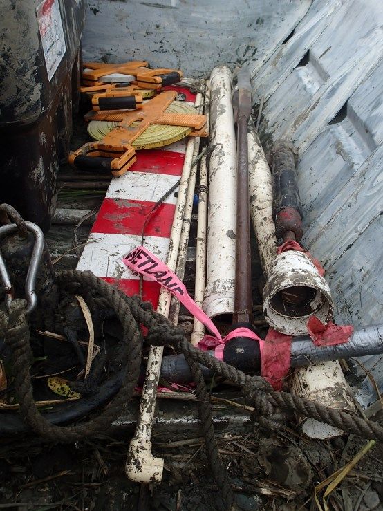
Objective 1: Monitoring & Assessment

Each wetland class is calibrated separately to produce weights for each wetland type. An overall score for a site
is calculated by subtracting the sum of the weights for all the stressors that are present from the possible score if
no stressors are present.

The Mid-Atlantic Rapid Assessment Method (MidTRAM) is a level II assessment for the condition of estuarine
emergent tidal wetlands in Delaware, Maryland and Virginia. MidTRAM is validated with intensive biological data
from vegetative biomass and marsh bird surveys. Optimal sampling for MidTRAM is during the local growing
season (July-September in Delaware). This method yields a condition score for buffer, hydrology and buffer
parameters as well as an overall condition score and condition category.

Value Assessment
A companion to the DERAP was created in 2013 to capture the non-condition related values that a wetland
offers. The Value-Added Protocol is a rapid assessment that uses field observations and computer-based
calculations to rate non-tidal wetlands on the opportunity to provide a function and the local significance of that
function. A wetland site is scored for polygon size, being a rare or unique wetland type in Delaware, for hosting
rare or endangered plants and animals, etc.

Comprehensive Field Assessment
The Delaware Comprehensive Assessment Procedure (DECAP) is a comprehensive assessment method for
determining the condition of a wetland site relative to reference condition. The DECAP and associated
assessment models have been developed and refined by both regional and national wetland scientists following
standard HGM development guidelines. Protocols for the DECAP can be obtained online or by contacting
DNREC Watershed Assessment Section.
The DECAP is used to collect detailed data on each site and encompasses a variety of parameters including
vegetation, hydrology, soils, topography, structure and surrounding landuses. The goal is to collect data on a
wide variety of parameters to determine which ones distinguish sites based on disturbance. These data are then
used to scale variables and functions for each wetland subclass. Variables (for example the density of trees per
hectare) are scaled based on the reference sites. The highest score of 1.0 indicates that the variable is equivalent
to a Reference Standard site (or minimally impacted) ranging down to a score of 0.1 for a highly degraded site
where restoration is possible, or 0.0 for a site where restoration is no longer possible for that variable. Variables
are then combined into mathematical equations that were developed by a group of wetland scientists to depict
functions including maintenance of characteristic hydrology, wildlife habitat integrity, plant community integrity,
biogeochemical cycling, and buffer integrity. The final function score is not an absolute value of performance of a
function but rather an index of how much that function is departing from a reference standard or minimally
altered site.
Field protocols and models are in different stages of development for the various wetland types in Delaware.
Once a method has been developed for a group of wetlands, it can be implemented for
monitoring purposes.
Intensive Assessment
Intensive assessment involves the direct measure of specific wetland functions, processes or ecosystem services.
Intensive assessments are performed to validate landscape, rapid, and comprehensive assessments and to
determine long term changes in wetlands. Currently, the WMAP has permanent monitoring stations in tidal
wetlands to collect baseline data on vegetation, sediment accretion and surface elevation, and to determine how
they are responding to different stressors and changing overtime. Monitoring stations in non-tidal flat and river
wetlands are being installed presently.

                                                       Page 7
GOAL A: MAPPING
Update wetland mapping tools and improve
access to wetland related spatial data
PROGRESS AND CURRENT STATUS
Delaware is fortunate to be a state where landscape level
mapping is spatially and financially feasible. Developing
updated wetland maps is critical to tracking and managing
wetlands as they face natural and anthropogenic changes.
Over the last five years significant effort has been made to
provide a ten-year update of statewide wetland maps.
Using 2017 aerial photographs, wetland census map layers
were created along with an analysis of wetland changes
since 2007.
This recent mapping effort incorporated many new
mapping features and techniques such as addition of
surface water features and removal of hydric soil
wetlands. Significant work remains to fully interpret,
summarize and disseminate the new resources and
implications.
Statewide wetlands according to 2017 wetland mapping project.
(WMAP) Additionally, DNREC has been leveraging opportunities to
share and use wetland data such as incorporating
watershed scale wetland health grades into the
Watershed Resources Registry.
The Delaware Wetlands website (http://de.gov/
delawarewetlands) also contains a library that shares
technical reports, protocols, presentations and published
articles. This webpage has been made possible through
the allocation of a staff member to maintain and update
the mapping web page, library and online communications.
Wetland condition grades in the Watershed Resource Registry (WMAP)
Page 8GOAL A: MAPPING
ACTION ITEMS
VISION STATEMENT
DNREC’s mapping focus in the next five years should be to utilize
the 2017 maps and results to the fullest extent, through
professional sharing and messaging to broader audiences. Given
the significant number of technical changes, thorough outreach and
presentation of results will be required. Additionally, DNREC
should make an effort to collaborate with partner agencies to
incorporate new resources into other related spatial tools for
planning and management projects. Red Lion watershed tidal wetland (WMAP)
Mapping capabilities continue to develop and become refined which provides more accurate wetland data. To be more
useful, all spatial data layers should be accompanied by complete metadata and should be made accessible to a wide
audience. The literature library should be kept current and promoted more to increase visitation and project sharing.
Prioritization for conservation and restoration should consider the goals of the Delaware Bayshore Initiative. Lastly,
there is a continued need for a streamlined database or web mapper that houses restoration project locations and
information from multiple sources. In order to have in-house capabilities to complete projects requiring specialized
mapping and analysis skills, staff positions must be supported.
ACTION ITEMS
A-1 UTILIZE 2017 STATEWIDE WETLAND MAPPING PROJECT (SWMP) MAPS AND REPORT to
further produce and analyze wetland status and trends results
A-2 DEVELOP UP-TO-DATE SPATIAL DATA RESOURCES (e.g., land use, flooding, LIDAR, sea level
rise predictions, ownership, protection status) to highlight overlapping areas prioritized for
protection or restoration
A-3 CONTRIBUTE TO AND PROMOTE USE OF A RESTORATION TRACKING WEBMAPPER such as
the Watershed Resource Registry to report, map and track wetland projects and opportunities
A-4 INCREASE USE OF MAPPING RESOURCES IN RELATED PROJECTS such as sea level rise research
and planning, transportation projects and mitigation planning
A-5 DEVELOP MORE GIS CAPABILITIES TO MAINTAIN WETLAND RELATED DATA SETS AND
LAYERS and assist with spatial analysis needs
A-6 MAINTAIN AND PROMOTE A MAP-BASED DATABASE OF VOLUNTEER MONITORING
PROJECTS AND INFORMATION
Page 9GOAL B: MONITORING
Increase monitoring efficiency and effort to
provide insight into wetland function
and health
PROGRESS AND CURRENT STATUS
On the ground monitoring of natural, restored or created
wetlands continue to provide valuable insight into wetland
health and function while enhancing opportunities to make
in-person observations that could not be derived from a
landscape census. Wetland condition and local trends are
Muddy monitoring equipment in boat (WMAP) reported on a watershed basis across the state. In the past
five years condition reports and supporting resources for
the Red Lion, Appoquinimink, Smyrna, Leipsic and Mispillion
watersheds have been published for the public. Currently,
science-based information is being incorporated into
watershed specific management recommendations that drive
restoration, protection and mitigation activities.
Several efforts to update protocols and provide appropriate
monitoring methods also took place. For example, the tidal
rapid assessment method (MidTRAM) was updated to reflect
the fullest extent of available wetland data. More
importantly, MidTRAM was adapted to also represent tidal
freshwater wetlands which were previously not assessed
using either MidTRAM or DERAP. Also, the collection of
wetland value data has continued and will feed the
refinement of the Value-added Protocol. Updates to
monitoring tools have been shared among DNREC
colleagues and outside partners through trainings and
presentations with the goal of adopting or utilizing the
available data.
Also, after years of discussion, the Delaware Department of
Transportation (DelDOT) and DNREC established an
agreement to adopt DERAP and MidTRAM results to set
mitigation ratios for small, unavoidable wetland impacts
during transportation improvement projects.
Seining for nekton on Indian River (WMAP)
Page 10GOAL B: MONITORING
ACTION ITEMS
VISION STATEMENT
Increased sampling of natural, restored, created and mitigated wetlands provides a
scientific basis for more effective planning and management. These data sets can
be interpreted to track the short-term variability and long-term changes in Sampling hydric soils (WMAP)
wetland resources and can support ongoing initiatives such as Watershed Management Plans, the Delaware Wildlife
Action Plan, and the National Estuarine Research Reserve (NERR) Research and Monitoring Plan. In addition to
developing specialized sampling protocols, trainings for practitioners are necessary to increase the adoption and use of
standardized methods. As operating procedures are developed for restoration techniques and other activities, advanced
trainings will be needed to connect the Departments (Natural Resources and Agriculture) with professionals.
To make the most of available sampling methods and existing data, access to information online should be strengthened
and clearly linked to other partner groups’ work. The use of various levels of wetland information including maps,
trends, methods and watershed condition reports should be promoted through online access and active sharing of
available tools and information. Developing a web-based portal in lieu of paper submissions will encourage volunteers to
contribute their collected data and improve the ease of reporting and tracking important volunteer hours.
A great way to engage citizens and supplement field observations is through volunteer and citizen science programs.
Adopt-a-Wetland is an example of such a program where volunteers contribute their time and can be effectively trained
to collect scientifically viable information. Through these programs, volunteers receive education about wetlands, and
leave with a sense of accomplishment and ownership for natural resources, but overhead costs, staff time for training and
oversight, as well as supplies must be covered in order for volunteer programs to succeed. A key priority for these
programs will be to secure a long-term funding source to support and sustain the contributions that volunteers can make
to monitoring efforts.
ACTION ITEMS
B-1 DEVELOP STANDARDIZED SAMPLING PROTOCOLS FOR ASSESSMENT AND MONITORING OF NATURAL,
RESTORED AND CREATED WETLANDS AND STREAMS. Protocols should use a tiered approach to
account for varying staff expertise, time commitment, and financial resources and should be revised
periodically
B-2 ENCOURAGE ADOPTION OF STANDARDIZED PROTOCOLS AND USE OF REFERENCE DATA FOR
WETLAND RESTORATION, MITIGATION, OR CREATION. Post the most up-to-date versions on the
Delaware Wetlands website for planning and permitting procedures
B-3 HOLD TRAINING WORKSHOPS TO TEACH AND PROMOTE USE OF MONITORING AND ASSESSMENT
PROTOCOLS, DATA COLLECTION METHODS AND QUALITY ASSURANCE TECHNIQUES for
environmental professionals, educators, and volunteer participants
B-4 USE REFERENCE AND ASSESSMENT DATA TO UPDATE AND ADAPT DERAP, DECAP AND MIDTRAM to
evaluate beaver impoundments
B-5 SHARE ASSESSMENT RESULTS ONLINE FOR ACCESS in data form, as technical reports, as wetland report
cards, in geospatial data form, and in public-friendly materials
B-6 ASSESS THE CONDITION OF WETLANDS BASED ON THE SPECIFIED WATERSHED SCHEDULE and the
National Wetland Condition Assessment in 2021
B-7 ESTABLISH CLEAR BASELINES FOR WETLAND CONDITION AND TRACK CHANGES OVER TIME on a
watershed and statewide basis
Page 11GOAL C: CLIMATE
ADAPTATION
Use available science and research to better
understand and plan for the effects of climate
change and sea level rise
on wetlands habitats
PROGRESS AND CURRENT STATUS
Delaware has recognized the vulnerability of its properties,
natural resources and infrastructure to inland and coastal
flooding, intense precipitation events and droughts. Efforts
began in 2000 with the Delaware Climate Change Impact
Assessment followed by the Delaware Sea Level Rise
Advisory Committee to assess possible impacts (including
those affecting wetlands; 2012) and provide prioritized
recommendations for adaptation to address those threats
(2013). In addition, eleven state agencies are acting under
Executive Order 41-Preparing Delaware for Emerging Climate
Impacts and Seizing Economic Opportunities to Reducing
SET monitoring in Lewes, DE (WMAP) Emissions (2013) to improve resiliency and develop strategies
for adaptation and preparedness. Now the focus is on
implementing high priority recommendations.
This goal was developed in response to wetland-related
questions and needs raised in the above mentioned
documents. For example, are wetlands keeping pace with sea
level rise? How are wetland plant communities adjusting to
rising salinity lines? Are tidal freshwater wetlands being
squeezed out between salt water intrusion and dams? How
can coastal habitats be strengthened against increased storm
energy?
Extensive loss of coastal habitat, including wetlands, will result
in the loss of revenue from hunting, angling, boating, wildlife
viewing and tourism. In addition, there will be impacts to
farmland from increased salinity and salt water inundation.
Fortunately, with federal support, several state, federal and
academic programs, as well as non-profit organizations are
already focused on investigating how wetlands are responding
to changing conditions. maintaining safety and quality of living
in Delaware for years to come.
Measuring sediment accretion in a feldspar plot (WMAP)
Page 12GOAL C: CLIMATE
ADAPTATION
ACTION ITEMS
VISION STATEMENT
Coastal wetlands, although resilient to storm energy and
environmental stresses, are threatened by an accelerated rate of
sea level rise and are limited in their migration inland due to coastal
development. Inland wetlands are threatened by erratic
precipitation, warmer temperatures, rising tide lines, and intruding
salt water. Much remains unknown about how wetlands are
being impacted by changing conditions, how they are responding
and how DNREC can take action to ensure that Delaware’s Rain Snags are visible as marsh migrates inland with
rising sea levels (WMAP)
wetlands and their valuable services are sustained into the future.
In collaboration with DNREC’s Coastal Programs, Division of Fish and Wildlife, University of Delaware, U.S. Geological
Survey, Delaware Geological Survey and various non-governmental organizations (NGO’s), the Division of Watershed
Stewardship will expand research to investigate wetland responses to sea level rise in terms of elevation, subsidence
rates, and shifting vegetation communities. In particular, research will include determining how wetlands migrate and
how habitat conversion is occurring as water levels rise. Areas that are identified as potential migration paths can be
protected or acquired. In addition, the Division of Fish and Wildlife needs to address how flooding and salt water will
affect wildlife impoundments and how to accommodate key species and habitats in the future. Another consideration to
better understand is the potential loss of carbon storage if expansive tidal emergent wetlands are converted to open
water. Research is needed to understand this wetland function, improve the methods to estimate the natural range of
carbon storage and determine a value for this service. Additionally, as stronger coastal storms become more common,
research will need to determine the impacts of marine debris on tidal wetlands.
In an effort to utilize research and mapping to its fullest, it is important to communicate key findings and implications with
landowners, planners and municipalities to raise awareness regarding sea level rise, changing coastal conditions and the
protection that wetlands provide. Delaware is a low lying state that relies on its coastal resources as part of its culture
and economy. Numerous groups are interested in the effects of sea level rise and climate change in Delaware and every
opportunity to collaborate and share information should be taken.
ACTION ITEMS
C-1 IDENTIFY COASTAL AREAS TO BE SECURED FOR POTENTIAL WETLAND MIGRATION that will improve
coastal protection and provide critical beach, marsh and forest habitat
C-2 STUDY AND INTEGRATE TRADITIONAL PRACTICES TO INCREASE COASTAL WETLAND HEALTH AND
RESILIENCY such as natural buffers, Phragmites control and coastal impoundment restoration
C-3 INVESTIGATE THE RISK OF FLOODING AND SALT WATER INTRUSION TO STATE WILDLIFE
IMPOUNDMENTS AND PONDS and consider how to support important wetland communities and related
species
C-4 Improve understanding of, and promote possible use of BLUE CARBON VALUE SYSTEM FOR COASTAL
WETLANDS AS IT RELATES TO CLIMATE CHANGE
C-5 INVESTIGATE THE ECOLOGICAL DYNAMIC OF HABITAT SHIFTS DUE TO SEA LEVEL RISE AND SALT WATER
INTRUSION in coastal wetlands such as ghost forests, marsh migration and high marsh-low marsh shifts
C-6 Support and expand on studies that MONITOR SEDIMENT RATES, WETLAND ELEVATION AND
SUSTAINABILITY OF COASTAL WETLANDS
C-7 REFINE SPATIAL IDENTIFICATION AND PRIORITIZATION OF SITES SUITABLE FOR DREDGE MATERIAL to
enhance shorelines and tidal wetlands
Page 13Five Year Schedule
Objective 1: Monitoring & Assessment
Action Items ‘21 ‘22 ‘23 ‘24 ‘25
A-1 UTILIZE 2017 STATEWIDE WETLAND MAPPING PROJECT (SWMP) MAPS AND REPORT to further produce and
analyze wetland status and trends results X X
A-2 DEVELOP UP-TO-DATE SPATIAL DATA RESOURCES (e.g., land use, flooding, LIDAR, sea level rise predictions,
X X
ownership, protection status) to highlight overlapping areas prioritized for protection or restoration
A-3 CONTRIBUTE TO AND PROMOTE USE OF A RESTORATION TRACKING WEBMAPPER such as the Watershed
Resource Registry to report, map and track wetland projects and opportunities X X
A-4 INCREASE USE OF MAPPING RESOURCES IN RELATED PROJECTS such as sea level rise research and planning,
transportation projects and mitigation planning X X
A-5 DEVELOP MORE GIS CAPABILITIES TO MAINTAIN WETLAND RELATED DATA SETS AND LAYERS and assist with
X X X
spatial analysis needs
A-6 MAINTAIN AND PROMOTE A MAP-BASED DATABASE OF VOLUNTEER MONITORING PROJECTS AND INFORMATION X X X
B-1 DEVELOP STANDARDIZED SAMPLING PROTOCOLS FOR ASSESSMENT AND MONITORING OF NATURAL, RESTORED
X X
AND CREATED WETLANDS AND STREAMS
B-2 ENCOURAGE ADOPTION OF STANDARDIZED PROTOCOLS AND USE OF REFERENCE DATA FOR WETLAND
X X X
RESTORATION, MITIGATION, OR CREATION.
B-3 HOLD TRAINING WORKSHOPS TO TEACH AND PROMOTE USE OF MONITORING AND ASSESSMENT PROTOCOLS,
DATA COLLECTION METHODS AND QUALITY ASSURANCE TECHNIQUES for environmental professionals, X X X X X
educators, and volunteer participants
B-4 USE REFERENCE AND ASSESSMENT DATA TO UPDATE AND ADAPT DERAP, DECAP AND MIDTRAM to evaluate
X
beaver impoundments
B-5 SHARE ASSESSMENT RESULTS ONLINE FOR ACCESS in data form, as technical reports, as wetland report cards,
X X X X X
in geospatial data form, and in public-friendly materials
B-6 ASSESS THE CONDITION OF WETLANDS BASED ON THE SPECIFIED WATERSHED SCHEDULE and the National
X X X X X
Wetland Condition Assessment in 2021
B-7 ESTABLISH CLEAR BASELINES FOR WETLAND CONDITION AND TRACK CHANGES OVER TIME on a watershed and
X X X
statewide basis
C-1 IDENTIFY COASTAL AREAS TO BE SECURED FOR POTENTIAL WETLAND MIGRATION that will improve coastal
X X
protection and provide critical beach, marsh and forest habitat
C-2 STUDY AND INTEGRATE TRADITIONAL PRACTICES TO INCREASE COASTAL WETLAND HEALTH AND RESILIENCY
X X
such as natural buffers, Phragmites control and coastal impoundment restoration
C-3 INVESTIGATE THE RISK OF FLOODING AND SALT WATER INTRUSION TO STATE WILDLIFE IMPOUNDMENTS AND
X X
PONDS and consider how to support important wetland communities and related species
C-4 Improve understanding of, and promote possible use of BLUE CARBON VALUE SYSTEM FOR COASTAL
X
WETLANDS AS IT RELATES TO CLIMATE CHANGE*
C-5 Investigate the ecological dynamic of habitat shifts due to sea level rise and salt water intrusion in coastal
X X
wetlands such as ghost forests, marsh migration and high marsh-low marsh shifts
C-6 Support and expand on studies that MONITOR SEDIMENT RATES, WETLAND ELEVATION AND SUSTAINABILITY
X X
OF COASTAL WETLANDS**
C-7 REFINE SPATIAL IDENTIFICATION AND PRIORITIZATION OF SITES SUITABLE FOR DREDGE MATERIAL to enhance
X X X
shorelines and tidal wetlands
*Supplemented with DNERR funds **Supplemented with NEP funds
Page 14Objective 2:
Protect and restore wetlands through a variety of
tools including voluntary incentive programs, and
integration with watershed strategies and
conservation plans.
Objective 2: Voluntary Restoration
& Protection
Objective 2 involves using the results generated from monitoring efforts to enhance voluntary wetland
restoration, management, and protection programs in the state. The data obtained during monitoring efforts will
serve to inform State programs and restoration partners regarding the type of wetlands most in need of
restoration and protection, which will be shared in watershed reports generated by the WMAP.
The WMAP can use wetland mapping resources and condition information to reach out to property owners of
unique or rare wetland communities to provide information and encourage voluntary protection. In addition,
results from status and trends reports will be used to message the need for greater voluntary wetland protection
and restoration. The WMAP will use assessment results to encourage the financial support for voluntary
protection and incentive programs in Delaware such as the Forestland Preservation Program.
Voluntary restoration will be promoted throughout the program’s outreach efforts. Based on assessment
results, restoration can focus on the dominant stressors that are impacting different wetland types. Watershed
level restoration plans in watersheds with completed wetland assessments will be developed using wetland data
and other relevant and available science-based information (e.g. rare species and communities, soils, hydrology,
land use). These plans will provide direction and detail for restoration and protection project planning. Wetland
health report cards will focus on communicating to landowners and managers how to improve wetlands based
on the management recommendations. Through online and written resources, the WMAP will encourage
landowners to become voluntary stewards to wetlands on their property and will connect eligible citizens with
incentive or assistance programs.
DE Living Shorelines Committee hosting a living shoreline site
evaluation training (WMAP)
Page 15Blackb
GOAL D: RESTORATION
Advance wetland restoration, creation and
enhancement practices to increase wetland
acreage, condition and function.
PROGRESS AND CURRENT STATUS
Wetland restoration has continued to evolve and advance by
the work of multiple DNREC Divisions, the U.S. Fish and
Wildlife Service, National Oceanic and Atmospheric
Administration and non-profit organizations such as the
Delaware Center for the Inland Bays, Partnership for the
Delaware Estuary, The Nature Conservancy, and
Delaware Wild Lands.
Adaptive maintenance on a living shoreline in
Blackbird Creek Reserve (WMAP) DNREC has been supportive and actively involved in testing
and developing restoration techniques in non-tidal and tidal
wetlands. The goal of these projects is to improve
restoration performance and increase the utilization of
techniques that benefit wetland habitats.
Watershed condition assessments have been completed and
reported, but using the assessment data to develop
watershed level restoration plans has been limited.
Revisions are expected to be made to allow for greater ease
in developing watershed restoration plans while still
providing polygon-specific restoration and protection
priorities for freshwater wetlands.
As the effects of sea level rise and stronger coastal storms
make noticeable changes to our coastlines and tidal
wetlands, restoration techniques in estuarine systems have
become more important. Demonstrations and training
workshops for traditional restoration techniques, as well as
for emerging practices, such as living shorelines, have been
organized and held to educate wetland scientists and private
sector practitioners.
Collecting elevation data to help design a tidal wetland
restoration using dredge material (WMAP)
Page 16GOAL D: RESTORATION
ACTION ITEMS
VISION STATEMENT
The development and use of sound restoration techniques followed by
thorough monitoring serves to increase wetland functions across
Delaware. Connecting the development of new and refined practices Counting mussels and oysters at a living shoreline
to consultants, engineers, and contractors is an important goal. As along the Indian River (WMAP)
connections with more private practitioners are developed, targeted
trainings should be continued and offered at more advanced levels.
Restoration efforts should dedicate more time and resources in planning for after-construction monitoring and the
identification of possible adjustments to sites for improved performance and success. Above all it is imperative that
wetland scientists, professionals, and landowners communicate openly to share the best available techniques, work
through adjustments, and put research results to use when designing and implementing successful projects.
Creating clear Best Management Practices (BMPs) and mitigation requirements for restoration efforts will make
reaching out to eligible landowners with restoration opportunities easier, more understandable and increase the
likelihood of participation and compliance.
Plans to guide wetland restoration projects should be developed through collaboration, based on a refined process for
prioritizing wetland polygons of greater ecological value and interest. Incorporation of existing information such as the
EcoMap, wetland maps and Watershed Resource Registry will facilitate the creation of targeted areas and projects.
During project design, the impacts of rising sea levels, changing precipitation patterns and salt tolerance should be
incorporated.
ACTION ITEMS
D-1 HOST WORKSHOPS TO SHARE WETLAND RESTORATION TECHNIQUES AND PRACTICES with
consultants, engineers, planners, wetland professionals and interested stakeholders
D-2 EDUCATE ELIGIBLE LANDOWNERS ABOUT RESTORATION AND CONSERVATION OPTIONS and
promote enrollment or participation through workshops, online materials and targeted communications
D-3 SUPPORT COLLABORATION AND INFORMATION SHARING BETWEEN PRIVATE AND PUBLIC SECTORS
to more effectively advance and improve wetland restoration practices and rates of success
D-4 DEVELOP WATERSHED LEVEL RESTORATION PLANS in watersheds with completed wetland
assessments using GIS analysis and stakeholder input
D-5 SUPPORT THE WETLAND RESTORATION GOALS OUTLINED IN THE CHESAPEAKE BAY AGREEMENT
D-6 DEVELOP, APPLY AND STANDARDIZE SCIENCE BASED TOOLS AND APPROACHES THAT HELP
ADVANCE SHORELINE RESTORATION and stem erosion in a variety of settings
D-7 Collaborate with stakeholders to ESTABLISH WETLAND BANKS THAT PROVIDE ECOLOGICAL UPLIFT
AND MEET PERFORMANCE STANDARDS
Page 17Five Year Schedule
Objective 2: Voluntary Restoration
& Protection
Action Items ‘21 ‘22 ‘23 ‘24 ‘25
D-1 HOST WORKSHOPS TO SHARE WETLAND RESTORATION TECHNIQUES AND PRACTICES with
X X X X X
consultants, engineers, planners, wetland professionals and interested stakeholders
D-2 EDUCATE ELIGIBLE LANDOWNERS ABOUT RESTORATION AND CONSERVATION OPTIONS
and promote enrollment or participation through workshops, online materials and targeted X X X
communications
D-3 SUPPORT COLLABORATION AND INFORMATION SHARING BETWEEN PRIVATE AND PUBLIC
SECTORS to more effectively advance and improve wetland restoration practices and rates of X X X X X
success
D-4 DEVELOP WATERSHED LEVEL RESTORATION PLANS in watersheds with completed wetland
X X
assessments using GIS analysis and stakeholder input
D-5 SUPPORT THE WETLAND RESTORATION GOALS OUTLINED IN THE CHESAPEAKE
X X
BAY AGREEMENT*
D-6 DEVELOP, APPLY AND STANDARDIZE SCIENCE BASED TOOLS AND APPROACHES THAT
X X X X
HELP ADVANCE SHORELINE RESTORATION and stem erosion in a variety of settings
D-7 Collaborate with stakeholders to ESTABLISH WETLAND BANKS THAT PROVIDE ECOLOGICAL
X X
UPLIFT AND MEET PERFORMANCE STANDARDS
*Supplemented with federal Chesapeake Bay funds.
Jewelweed flower (WMAP)
Tidal Marsh
Page 18Objective 3:
Inform the citizens and visitors of Delaware
about the functions and services of wetlands.
Collaborate with State programs and
Objective 3: Education & Collaboration conservation partners to improve project
efficiency and effectiveness.
Objective 3 is focused on linking information on the
status of wetlands in Delaware to the decision making
process and improving the condition of wetlands on the ground. Outreach and education efforts will focus on
relaying information from the monitoring, assessment, and research efforts as well as the overall value and
services of wetlands. By raising awareness of Delaware’s rich wetland resources and the valuable services they
provide, residents and visitors will appreciate wetlands and work towards a sustainable way of life that allows
wetlands to persist for generations to come.
The WMAP will also focus on greater collaboration with state programs and conservations partners to share
projects and improve efficiency. Through participation on work groups and by establishing lines of
communication with related programs, data, methods and findings will be imparted, reducing redundancy and
increasing the integration of wetland monitoring and assessment information. The WMAP will take a lead role in
facilitating data sharing and the transfer of knowledge among professionals.
The assessment of wetland condition, including the
identification of major stressors that are impacting wetlands as
determined through the monitoring program, will be valuable
for wetland education efforts. The goal is to share wetland
condition information and the implications of wetland impacts
with conservation partners, decision makers and the public to
gain their support in reducing wetland impacts through
restoration, management and protection. Literature and online
resources are being designed to share with the public in order
to educate them in ways that they can work with their local
land use decision makers to protect wetlands from encroaching
development. The Delaware Wetlands website also serves the
public by instructing homeowners on steps to minimize their
footprint on their local watershed. Written and online
materials as well as social media programs are designed to
engage citizens and communities to connect with the resources
around them.
Filming educational video (WMAP)
Page 19GOAL E: COLLABORATION
Facilitate collaboration and project sharing
among wetland science programs, educators
and practitioners
PROGRESS AND CURRENT STATUS
DNREC and the Department of Agriculture have improved the
level of collaboration and project sharing between related
departments. This has in turn increased efficiency and
strengthened relationships between some programs with similar
goals to protect and conserve wetlands. There is still a need for
more opportunities to stay connected to other groups.
Living shoreline training workshop (WMAP) In terms of reaching a large audience, the most successful effort
to share wetland science and projects has been the biennial
Delaware Wetlands Conference. In both 2012 and 2014 this
event attracted over 250 attendees bringing together
professionals and stakeholders from all sectors. These events
informed participants about emerging topics, new technologies,
current research endeavors, future needs for improving wetland
protection and conservation and encouraged networking
among colleagues.
DNREC has been successful in facilitating the completion of
wetland-related projects with non-government organizations
through technical advising or financial support. The formation of
“work groups” such as the Delaware Living Shoreline
Committee, Chesapeake Bay Wetland Work Group, Mid-
Atlantic Wetland Work Group (MAWWG), the Mid-Atlantic
Collaborative Living Shoreline Project Between Wetland Coastal Wetland Assessment Working Group (MACWA) and
Monitoring and Assessment Program, Partnership for the the National Wetland Monitoring and Assessment Work Group
Delaware Estuary and Delaware Center for the Inland Bays (NWMAWG) have been critical for informing other states and
(WMAP)
organizations about Delaware’s projects and advances in wetland
science. In addition, the Departments have benefited from the
expertise and advice gained through shared insights, personal
connections, and transferred technologies. Through these
relationships Delaware’s wetland programs have become
recognized and respected in the Mid-Atlantic region.
In an effort to connect wetland science with decision makers,
biologists met with Kent County planners in a series of meetings
regarding available wetland information and how to incorporate
more wetland health findings into the review of proposed
landuse projects. There was limited success in changing the
current process.
Wetland Assessment Method Workshop (2014; WMAP)
Page 20You can also read