Template-Based Question Answering over Linked Geospatial Data
←
→
Page content transcription
If your browser does not render page correctly, please read the page content below
Template-Based Question Answering over Linked Geospatial Data

                                           Dharmen Punjania , Markos Iliakia , Theodoros Stefoua , Kuldeep Singhb , Andreas Bothc,d ,
                                          Manolis Koubarakisa , Iosif Angelidisa , Konstantina Beretaa , Themis Berisa , Dimitris Bilidasa ,
                                            Theofilos Ioannidisa , Nikolaos Karalisa , Christoph Langee , Despina-Athanasia Pantazia ,
                                                                   Christos Papaloukasa , Georgios Stamoulisa
                                                 a Department of Informatics and Telecommunications, National and Kapodistrian University of Athens

                                           {dpunjani, koubarak, iosang, konstantina.bereta, tberis, d.bilidas, tioannid, nkaralis, langec, dpantazi, christospap,
                                                                                           gstam}@di.uoa.gr
                                                                   b Cerence GmbH, Aachen, Germany, kuldeep.singh1@cerence.com
                                                                            c DATEV eG, Germany, contact@andreasboth.de
arXiv:2007.07060v1 [cs.IR] 14 Jul 2020

                                                         d Anhalt University of Applied Science, Köthen, Germany, andreas.both@hs-anhalt.de
                                                             e Fraunhofer FIT, Sankt Augustin, Germany, lange@informatik.rwth-aachen.de

                                         Abstract
                                         Large amounts of geospatial data have been made available recently on the linked open data cloud
                                         and the portals of many national cartographic agencies (e.g., OpenStreetMap data, administrative
                                         geographies of various countries, or land cover/land use data sets). These datasets use various
                                         geospatial vocabularies and can be queried using SPARQL or its OGC-standardized extension
                                         GeoSPARQL. In this paper, we go beyond these approaches to offer a question-answering en-
                                         gine for natural language questions on top of linked geospatial data sources. Our system has
                                         been implemented as re-usable components of the Frankenstein question answering architecture.
                                         We give a detailed description of the system’s architecture, its underlying algorithms, and its
                                         evaluation using a set of 201 natural language questions. The set of questions is offered to the re-
                                         search community as a gold standard dataset for the comparative evaluation of future geospatial
                                         question answering engines.
                                         Keywords: Linked Geospatial Data, General Administrative Divisions dataset (GADM),
                                         OpenStreetMap, Question Answering, GeoSPARQL, Information Retrieval, Semantic web

                                         1. Introduction

                                             The number of data sources in private environments, enterprises, and the Web is increasing
                                         continuously, increasing the effort of making data accessible. One important means of making
                                         data accessible is question answering (QA), which provides a natural language interface for com-
                                         mon users to express their information needs [1]. Users commonly pose questions or information
                                         requests with a geospatial dimension to search engines, e.g., “Christmas market in Germany”,
                                         “Schools in London”, “Is there a Macy’s near Ohio?”, “Which countries border Greece?”. An-
                                         swering such questions or information requests requires data that has a geospatial dimension as
                                         well.
                                             Geospatial or geographic knowledge has been studied for many years by researchers in
                                         Geography, Geographic Information Systems (GIS), Geographic Information Retrieval (GIR),
                                         Databases, Artificial Intelligence and the Semantic Web, and there is a wealth of research results
                                         Preprint submitted to Revised version                                                                       July 15, 2020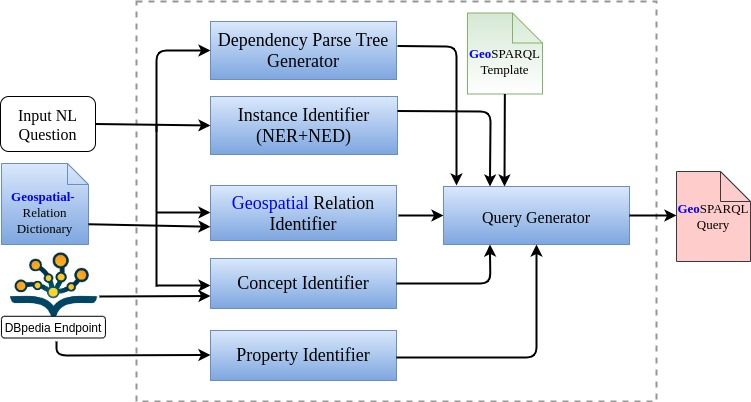
concerning representation, querying and inference for geographic knowledge. In GIS terminol-
ogy which we use in this paper, a geographic feature (or simply feature) is an abstraction of a real
world phenomenon and can have various attributes that describe its thematic and spatial char-
acteristics. For example, the country Greece is a feature, its name and population are thematic
attributes, while its location on Earth in terms of polar co-ordinates is a spatial attribute. Knowl-
edge about the spatial attributes of a feature can be quantitative or qualitative. For example, the
fact that the distance between Athens and Salonika is 502 km is quantitative knowledge, while
the fact that river Evros crosses Bulgaria and Turkey and is at the border of Greece with Turkey
is qualitative knowledge. Quantitative geographic knowledge is usually represented using ge-
ometries (e.g., points, lines and polygons on the Cartesian plane) while qualitative geographic
knowledge is captured by qualitative binary relations between the geometries of features.
     A significant fraction of the available data on the Web is geospatial, and this fraction is
growing by 20 percent or more per year [2]. Qualitative Geospatial data can be expressed as
a property of an entity or an explicit assertion. For example, in the RDF dataset DBpedia1 ex-
tracted from Wikipedia, the resource dbr:Berlin has a data property dbo:Country with value
dbr:Germany enabling the answering of questions such as “Cities in Germany” using DBpedia.
Or a dataset like DBpedia can contain the fact dbr:Berlin ogc:sfWithin dbr:Germany and
the question “Which cities are in Germany?” can again be answered using this dataset. Quan-
titative Geospatial data can be expressed by a property of an entity which has value a geometry
(latitude/longitude pair or polygon). Then, the question “Which cities are within 100 km of
Berlin?” can be answered by retrieving the geometry of the resource dbr:Berlin from an ap-
propriate geospatial dataset, and then computing the distance of this geometry to the geometries
of cities outside Berlin. In this paper, we focus on question answering from qualitative and
quantitative geospatial knowledge made available on the Web as linked open data.
     Examples of geospatial data published on the Web as linked open data include geospatial
data from various countries (e.g., the United Kingdom2 or The Netherlands3 ), OpenStreetMap
data (published in RDF by project LinkedGeoData4 [3] but also by our AI group at the National
and Kapodistrian University of Athens5 ), and land cover/land use data sets (e.g., the European
CORINE land cover dataset published in RDF by our group in the context of various European
projects). Queries over such data can be asked using the linked data query language SPARQL
and its geospatial extensions GeoSPARQL6 and stSPARQL [4]. However, to better serve the
needs of non-technical end users, it would be worthwhile to offer a natural language interface to
linked geospatial data based on QA techniques. To the best of our knowledge, none of the QA
systems utilizing linked data developed in recent years [5] deals with geospatial data. The work
presented in this paper makes the first steps towards this direction.
     In a similar spirit, the GIR community has been emphasizing the need to develop techniques
for answering geographic questions expressed in natural language over text data since 2004.7 The
importance of the research issues studied in GIR can also be seen by the fact that interaction with
geospatial search engines on mobile devices today is often done using spoken natural language

  1 http://wiki.dbpedia.org/
  2 http://data.ordnancesurvey.co.uk/
  3 https://www.kadaster.nl/-/bag-linked-data
  4 http://linkedgeodata.org/About
  5 http://ai.di.uoa.gr/#datasets
  6 http://www.opengeospatial.org/standards/geosparql
  7 http://www.geo.uzh.ch/~rsp/gir18/

                                                 2
(e.g., in Google Maps you can ask for directions to a place and these directions are then spoken
to you). This is in agreement with the vision of multimodal spatial querying presented in [6].
Geographical knowledge is also very important in the new generation of personal assistants such
as Amazon Alexa or Google Home.
Important assets of the GIR and QA research communities are the gold standards i.e., datasets
and sets of questions that can be used to test the effectiveness of developed systems and perform
detailed comparisons of them. In the area of QA over linked data, such gold standards have
recently been provided by the QALD challenge8 . To the best of our knowledge, no gold standard
for geospatial question answering over linked data has been proposed so far by QALD or any
other relevant research activity.
The contributions of this paper are the following. We have designed and implemented
GeoQA, the first question answering system for linked geospatial data. GeoQA is implemented
using reusable components as part of the component-oriented Qanary question answering method-
ology [7, 8] and its most recent implementation Frankestein [9].
We have also developed a gold standard for question answering over linked geospatial data
which consists of two parts. The first part is a linked geospatial dataset built from DBpedia, the
GADM database of global administrative areas9 and OpenStreetMap (OSM)10 . For the purposes
of the gold standard, GADM and OSM have been restricted to the United Kingdom and Ireland.
The second part of the gold standard consists of 201 geospatial questions that have been collected
by student volunteers at the National and Kapodistrian University of Athens. The gold standard
is used in a evaluation of the effectiveness of GeoQA and it is also made freely available to
the research community for evaluating other future proposals.11 In this way, we contribute to a
long-term research agenda towards question answering systems with geospatial features.
A previous version of this paper has been presented in the 12th Workshop on Geographic
Information Retrieval (GIR’18) [10]. The current version of the paper contains the following
additional contributions:
• We added support to the question patterns of Categories 1 and 6, and count questions of
Category 7 of the gold standard question set.
• We have performed a detailed study of existing named entity recognizers and disambigua-
tors to select the one we have used in the GeoQA engine (see Section 5.2).
• We performed various optimizations and code improvements in the instance identifier,
property identifier and query generator of our engine (see Section 5).
• As a result of the above, we have now achieved much higher precision, recall and f-
measures compared to the previous version of the GeoQA engine presented in [10].
The rest of the paper is organized as follows. The next section presents related work. Sec-
tion 3 presents the three datasets of the gold standard and the interlinking of GADM and OSM
with DBpedia. Section 4 presents the gold standard questions. Section 5 presents our approach
to building the query answering pipeline used by GeoQA. Section 6 presents an evaluation of
GeoQA using the gold standard. Section 7 concludes the paper and discusses future work.
8 https://qald.sebastianwalter.org/
9 http://www.gadm.org/
10 https://www.openstreetmap.org
11 http://geoqa.di.uoa.gr/
32. Related Work
Since the first workshop in this field in 2004, question answering over textual data with
geospatial information has been studied by Geographic Information Retrieval researchers. Rele-
vant problems in this area include detecting place names (a special case of named entity recogni-
tion) and associated spatial natural language qualifiers in text and user queries, and disambiguat-
ing place names (a special case of named entity disambiguation). Two representative examples
of systems where some of these issues have been studied are SPIRIT [11] and STEWARD [12].
An important evaluation initiative for geographic information retrieval from multilingual text
has been GeoCLEF.12 From the 2008 version of GeoCLEF, the GiKiP pilot is complementary to
our paper since it concentrated on answering geospatial questions in three languages (Portuguese,
English and German) from Wikipedia [13].
Query processing for linked geospatial data has been an active field of research recently
culminating in the definition of the OGC standard GeoSPARQL, an extension of SPARQL with
a vocabulary, datatypes and functions for expressing geospatial queries over linked data. There
has also been substantial activity in the implementation of query processing systems such as
Strabon [4] and Ontop-spatial [14], which both support GeoSPARQL. The work of the present
paper goes beyond these query processors to offering question answering services over linked
geospatial data, i.e. supporting queries expressed in natural language.
The work by Younis et al. [15] is most closely related to our work since it presents a system
for answering geospatial questions over DBpedia. The system is based on a PostGIS13 database
containing precise geospatial information of features in the United Kingdom provided by Ord-
nance Survey, a spatial index of DBpedia resources built using their point coordinates, and a
SPARQL endpoint storing the DBpedia dataset. The three classes of questions considered are
proximity “Find churches within 1 km of the River Thames”), crossing (e.g., “Find the mouths
of the rivers that cross Oxford”) and containment (e.g., “Find churches in Manchester”). As we
will see in Section 5, these kinds of questions are a subset of the ones that can be handled by
GeoQA. Younis et al.[15] informally discusses the techniques that can be used to answer such
questions, however, the system and dataset are not provided. Finally, the discussion in the paper
pays some attention to the quality of returned answers.
Grutter et al. [16] explore the use of DBpedia and Geonames for answering topological
queries involving administrative divisions of Switzerland and Scotland (since the authors are
very familiar with the administrative geographies of these two countries). The paper contains
a detailed discussion of quality issues in linked geospatial data and especially the two linked
data sources used by the authors (e.g., incompleteness, inconsistency of data etc.). Finally, the
paper considers queries for neighbouring and containing/contained administrative divisions, and
measures precision and recall when only one of datasets or both linked datasets are used.
Hamzaie et al. [17] analyzes the natural language question-answer dataset MS MARCOV2.1
[18] which contains questions posed to the Bing search engine and human-generated answers.
They concentrate on place-related questions of this dataset and define a set of patterns that can
be used to characterize semantically questions and their answers. They also present a deeper
understanding of the dataset using techniques based on word embeddings and clustering.
Tang and Mooney in [19] presents an inductive logic programming approach for learning
a semantic parser and applies its techniques to two areas, one of which is querying geospatial
12 http://www.clef-initiative.eu/track/GeoCLEF
13 http://postgis.net/
4databases. They have experimented with a dataset consisting of 1000 Prolog facts from the U.S.
Geography domain, and have also developed a corpus of 880 natural language questions and
their corresponding logical queries in Prolog.14 A part of this corpus is used to train the semantic
parser developed by the authors.
As it is already mentioned, in the area of QA there is currently no engine that deals with
geospatial questions like GeoQA. From the existing systems, PowerAqua needs to be mentioned
in our context since it also assumes that questions will be answered from many datasets or on-
tologies [20].
3. Constructing a Gold Standard Geospatial Data Set
In this section we discuss how to construct a gold standard geospatial dataset by interlinking
DBpedia, OpenStreetMap and the GADM dataset of global administrative areas. Since DBpe-
dia contains very limited geospatial information (e.g., latitude/longitude pairs, qualitative infor-
mation via predicates such as dbo:Country), we enrich DBpedia with quantitative geospatial
information (i.e., geometries) by interlinking it with OSM and GADM.
GADM is a dataset containing information about administrative divisions of various countries
and their boundaries. GADM 3.4 (released on May 2018) contains information about 386,735
administrative areas. Particularly, the multi-polygon for each administrative area is provided
along with a set of qualitative data, including its name and variant names. As the already existing
linked data form of GADM [21] was based on very old version of GADM (and its representation
was not based on the GeoSPARQL standard ) we created a new linked data form of GADM from
the available shapefiles using the tool GeoTriples15 . We have the data from release version 2.8
(released on November 2015 ). For the purposes of this paper, we have only used GADM data
from the United Kingdom (England, Scotland, Wales and Northern Ireland) and Ireland. The
graphical representation16 and the RDF/XML form17 of the GADM ontology used are publicly
available. Throughout the paper we use the prefix gadmr: instead of http://www.app-lab.
eu/gadm for resources in the GADM data, and gadmo: for http://www.app-lab.eu/gadm/
ontology for resources in the GADM ontology.
OSM is a collaborative project to create a free editable map of the world. It contains infor-
mation about various features like rivers, lakes, cities, roads, points of interest (e.g., museums,
restaurants and schools) etc. The geometries of these features can be points, lines or polygons.
In addition to the geometry of a feature, OSM contains useful information such as name, feature
class and layer. OSM data can be obtained in various formats. The first project to transform OSM
data into RDF was LinkedGeoData [3]. Currently, this project does not provide an up-to-date
version of OSM data that we could use for our study. For this reason, we had to repeat some of the
work presented in [22] and, by doing this, go beyond [22] in the way that we will explain below.
In the rest of the paper we use the prefix osmr: instead of http://www.app-lab.eu/osm for
resources in the OSM data, and osmo: instead of http://www.app-lab.eu/osm/ontology
for resources in the OSM ontology.
We obtained the OSM dataset in shapefile format from the company GEOFABRIK 18 and
converted it into RDF using the tool GeoTriples. These shapefiles contain data available on
14 http://www.cs.utexas.edu/users/ml/nldata/geoquery.html
15 http://geotriples.di.uoa.gr
16 http://geoqa.di.uoa.gr/images/gadm_ontology.png
17 http://geoqa.di.uoa.gr/assets/GADM.owl
18 http://download.geofabrik.de/europe.html
5Table 1: Interlinking GADM with DBpedia
Country Total Linked Linked
entities automatically manually
UK 197 164 33
Ireland 27 17 10
date 30th August 2017. Like GADM, we have restricted our attention to the United Kingdom
and Ireland. We designed a new ontology for OSM data which closely models the data in the
shapefiles and made it publicly available in graphical format19 and in RDF/XML format20 . The
ontology uses the GeoSPARQL vocabulary to model the geometries of various OSM features.
Note that OSM does not have detailed administrative boundaries of various countries, hence we
retrieve this information from GADM.
DBpedia is one of the most popular knowledge graphs derived from Wikipedia and its ontol-
ogy which we use in the paper is publicly available21 . Throughout the paper we use the prefix
dbo: instead of http:dbpedia.org/ontology for resources in the DBpedia ontology, and dbr:
instead of http://dbpedia.org/resource for resources in the DBpedia knowledge graph.
Interlinking of GADM and OSM with DBpedia allows us to answer geospatial questions that
cannot be answered by any of the datasets in isolation. For example, the question“Which of the
English counties that border Greater Manchester has the highest percentage of ethnic Asians?”
can only be answered by consulting GADM to find the counties that border Greater Manchester,
and then DBpedia to find the percentage of various ethnic groups in these counties. Also, the
question “Which Greek politicians are graduates of a university located in a Greek island belong-
ing to the region of Western Greece?” can be answered only by consulting all three datasets.
3.1. Interlinking GADM with DBpedia
The interlinking of GADM with DBpedia was done as follows. For each administrative
area mentioned in GADM we obtain the DBpedia resource which has the same label, by using
DBpedia SPARQL endpoint. The few remaining GADM resources were mapped manually. This
procedure resulted in most of the GADM resources being linked. The remaining ones were
linked manually. Table 1 shows the relevant numbers.
3.2. Interlinking of OSM with DBpedia
The task of interlinking OSM with DBpedia had some interesting challenges. First of all,
we manually identified classes that have the same or very similar label in DBpedia and OSM.
These classes are: Airport, Bank, Beach, Building, Canal, Castle, Cemetery,
Church, City, College, Dam, Forest, Fort, Glacier, Golfcourse, Hospital,
Hotel, Island, Library, Lighthouse, Locality, Memorial, Mine, Monument,
Mosque, Museum, Park, Place, Prison, RailwayStation, Region, Restaurant,
River, Road, School, Stadium, Stream, Temple, Theatre, Tower, Town, Tram,
University, Village, Volcano, Watertower, Watermill, Windmill, and Zoo.
Then, interlinking was performed on a class-by class basis using the tool Silk [23]. The OSM
19 http://sites.pyravlos.di.uoa.gr/dragonOSM.svg
20 http://pyravlos-vm5.di.uoa.gr/osm.owl
21 http://mappings.dbpedia.org/server/ontology/classes/
6data is stored in a Strabon endpoint and the online DBpedia endpoint is used for the DBpedia
data. The labels of the entities and the spatial distance of their geometries were considered
equally for matching. In other words, we use the formula (S (x, y) + MinDist(x, y))/2 = 1.0
where
• x and y are the instances considered for matching in OSM and DBpedia respectively.
• S (x, y) is the Levenshtein string similarity measure between the labels of x and y. The
threshold considered for string similarity is 85%.
• MinDist(x, y) is the minimum Euclidean distance between the geometries of x and y. Af-
ter experimenting with different number of threshold values for Euclidean distance, we
finalized the threshold to 1 kilometer.
Table 2 gives the number of instances of the various classes in both datasets, as well as the
number of instances that were interlinked. The DBpedia instances have been selected by retriev-
ing only the resources that have coordinates falling inside the minimum bounding rectangles of
the geometries of the United Kingdom and Ireland. As it is expected, some classes have many
more instances in one of the datasets. For example, the class Restaurant has 24055 instances in
the subset of OSM that we consider and only 152 instances in DBpedia. Also, some of the classes
having the same label are at different places in the class hierarchies of the two datasets. For ex-
ample, the class Building is the parent class of Restaurant, Hotel, Hospital, Museum
etc. in the DBpedia ontology, while it does not have any subclasses in the hierarchy of the OSM
ontology, so we interlink instances of the subclasses of Building with the instances of corre-
sponding classes of OSM. Similarly, Road has subclasses that we consider in OSM ontology,
while it does not have any subclasses in DBpedia. Naturally, when a class had zero instances
in one or both datasets (e.g., Beach in the DBpedia subset we consider and Glacier in both
datasets) then the class does not participate in the interlinking and does not appear in Table 2.
Finally, we would like to mention that we found many misclassified instances in DBpedia in
contrast to the other two datasets; this has also been pointed out in [22].
Let us now comment on some rows of Table 2 where there is an unexpectedly big difference
in the number of instances in OSM and DBpedia for the same class. Let us take for example
the class Airport. Unfortunately, the freely available OSM shapefiles for the United Kingdom
and Ireland, provided by GEOFABRIK 22 , contain only 7 airports (not even Heathrow airport of
London is included!). On the contrary, DBpedia has a rather large number resources classified
as airports. In some cases, these are wrongly classified e.g., dbr:Brahan_Castle, a castle, is
wrongly classified as dbo:Airport. It is also interesting to consider the row for class River.
There are many more instances of River in OSM than in DBpedia because OSM has a different
entry for each of the segments/polygons making up a river in its full length. The same issue
exists for the classes Canal and Stream. This is the reason that the number of total interlinked
instances is bigger than the cardinality of the intersection of the two datasets for classes like
River. Finally, another reason for the difference in instances between the same classes in DB-
pedia and OSM is the nature of the domain of interest in the datasets. For example, DBpedia has
information about only 1339 hotels in its full dataset of which 212 hotels are in the United King-
dom and Ireland. The corresponding number of hotels in OSM is 9819 hotels as we see from
22 http://download.geofabrik.de/europe.html
7the Table 2. In a similar way, the class Restaurant in DBpedia has few instances compared to
OSM.
After completing the interlinking with Silk, there were some entities that were not linked.
These were checked and linked, if appropriate, manually. For matches below 100 all matching
pairs were checked manually for correctness. For larger numbers of matching pairs, we checked
manually 100 random pairs and found them all to be correct. So, we conclude that our matching
process is very accurate.
Comparing the interlinking of OSM and DBpedia that we have done with the interlinking
done in LinkedGeoData [22], we can see that we have interlinked instances belonging to many
more classes. The OSM dataset in the case of LinkedGeoData is stored using Virtuoso which
has support only for point geometries. Therefore, no queries involving complex geometries can
be done, and the interlinked resources in the case of LinkedGeoData are limited to OSM nodes.
The GADM and OSM datasets as well as the interlinking dataset is publicly available on the
Web site of the gold standard.23 We will call this data part of the gold standard GeoData201.
4. Creating a gold standard set of geospatial questions
To be able to evaluate the effectiveness of our query engine and compare it with other QA
engines available, we have created a new benchmark set of 201 questions which we have col-
lectively called GeoQuestions201. The questions have been written by third-year students of the
2017-2018 Artificial Intelligence course in our department. The students were asked to target the
above three data sources by imagining scenarios where geospatial information will be needed
and could be provided by an intelligent assistant, and to propose questions with a geospatial di-
mension that they considered “simple” (a few examples of such questions were provided). The
authors of the paper have then “cleaned” the given set of questions and produced the SPARQL
or GeoSPARQL queries that correspond to them assuming ontologies that describe the three data
sources using the GeoSPARQL vocabulary. The complete set of resources (data sources, ontolo-
gies, natural language questions and SPARQL/GeoSPARQL queries) is available on the Web at
http://geoqa.di.uoa.gr.
The questions in the benchmark GeoQuestions201 fall under the following categories. For
each one of the categories, we also comment on whether two major search engines (Google and
Bing) can answer questions in this category.
1. Asking for the attribute of a feature. For example, “Where is Loch Goil located?” or
“What is length of River Thames?”. In GeoQA, these questions can be answered by posing
a SPARQL query to DBpedia. Google and Bing both can also answer such questions
precisely.
2. Asking whether a feature is in a geospatial relation with another feature. For example, “Is
Liverpool east of Ireland?”. The geospatial relation in this example question is a cardinal
direction one (east of). Other geospatial relations in the set of questions include topo-
logical (borders) or distance (near or “at most 2km from"). In GeoQA, these questions
are answered most of the time by using GADM and OpenStreetMap because the relevant
qualitative geospatial knowledge is not present in DBpedia and/or the detailed geometries
of features are needed for evaluating the geospatial relation of the question. Google and
23 http://geoqa.di.uoa.gr
8Table 2: Interlinking OSM with DBpedia
No. Total
No. Interlinked
of In- Inter-
of In- Interlinked Instances
Class stances linked
stances Instances (semi auto-
in DBpe- In-
in OSM matically)
dia stances
Airport 7 815 1 5 6
Bank 7621 29 1 2 3
Canal 7902 167 2171 920 3091
Castle 1357 486 161 36 197
City 86 101 45 18 63
College 1529 38 0 2 2
Dam 330 26 1 3 4
Hospital 2352 537 244 149 393
Hotel 9819 212 73 81 154
Island 2477 750 219 138 357
Library 3635 119 47 25 72
Lighthouse 423 39 9 14 23
Monument 2108 38 5 3 8
Museum 2313 933 327 219 546
Park 54830 382 252 103 355
Prison 207 199 28 119 137
Railway Station 3932 45 0 0 0
Region 13 151 0 0 0
Restaurant 24058 152 31 30 61
River 52897 785 4342 237 4579
School 33217 5556 2683 691 3374
Stadium 799 687 120 78 198
Stream 240293 470 885 265 1150
Theatre 1224 86 19 33 52
Tower 2373 35 0 0 0
Town 1960 1066 132 18 150
University 2466 1099 169 41 210
Village 15743 15346 4308 4087 8395
9Bing both cannot answer such factoid questions; both can only return a list of relevant Web
pages.
3. Asking for features of a given class that are in a geospatial relation with another feature.
For example, “Which counties border county Lincolnshire?” or “Which hotels in Belfast
are at most 2km from George Best Belfast City Airport?”. The geospatial relation in the
first example question is a topological one (border). As in the previous category, other
geospatial relations in the set of questions include cardinal (e.g., southeast of) or distance
(near or “at most 2km from” as in the second example question). In GeoQA, these ques-
tions can be answered by using not just DBpedia but also GADM and OpenStreetMap
when the detailed geometries of features are needed for evaluating the geospatial relations.
Google can also answer such questions precisely in many but not all cases (e.g., it can
answer precisely the first and third questions but not the second). Bing cannot answer such
questions precisely but gives list of relevant web pages.
Questions in this category might also have a second geospatial relation and a third feature
which are used to further constrain the second feature. For example, “Which restaurants
are near Big Ben in London?” or “Which rivers cross London in Ontario?”. In the first
question, we have also provided some more information about Big Ben although this might
not have been necessary.24 In the second question, “in Ontario” is used to make clear that
we are referring to the city London in Ontario, Canada not the more well-known city of
London in England.25
4. Asking for features of a given class that are in a geospatial relation with any features of
another class. For example, “Which churches are near castles?”. Arguably, this category
of questions might not be useful unless one specifies a geographical area of interest; this
is done by the next category of questions.
5. Asking for features of a given class that are in a geospatial relation with an unspecified
feature of another class which, in turn, is in another geospatial relation with a feature
specified explicitly. An example of such a question is “Which churches are near a castle in
Scotland?”. Google and Bing both cannot answer such questions precisely.
6. The questions in this category are like the ones in Categories 3 to 5 above, but in addition,
the thematic and/or geospatial characteristics of the features that are expected as answers
(i.e., the features of the first class mentioned in the question) satisfy some further condition
(e.g., numeric). For example, “Which mountains in Scotland have height more than 1000
meters?” or “Which villages in Scotland have a population of less than 500 people?” or “Is
there a church in the county of Greater Manchester dedicated to St. Patrick?” or “Which
Greek restaurants in London are near Wembley stadium?”. In these examples, the extra
attribute conditions may require GeoQA to consult all three data sources to find the answer
to a question. Google can answer precisely the first, third and fourth example question,
but not the second, since its knowledge graph does not contain population information for
villages in Scotland. Bing cannot answer any questions precisely but returns relevant links
to points of interest.
7. Questions with quantities and aggregates. For example, “Which is the highest mountain
in Ireland?” or “Which hotel is the nearest to Old Trafford Stadium in Manchester?” or
24 The authors of this paper are not aware of another Big Ben.
25 Boringly enough, London, Ontario is also crossed by a Thames river. We bet this is not how this river was called by
native Indians in 1534 when Canada was discovered.
10“Which is the largest lake by area in Great Britain?” Questions with quantities but without
aggregates have recently been studied by [24] in a non-geospatial setting. Interestingly,
Google and Bing both can answer all three example questions precisely. Note that ques-
tions in this class might also exhibit features of the previous two classes e.g., when a
topological relation is involved or when the condition on an attribute refers to a quantity
(e.g., height of a mountain). Such questions cannot be handled by QA engines as well as
Google and Bing at the moment. For example, the question “Which is the largest county
of England by population which borders Lincolnshire?” is answered incorrectly by Google
(county Bristol is given as the answer) as well as by Bing.
The list of benchmark questions is available publicly26 .
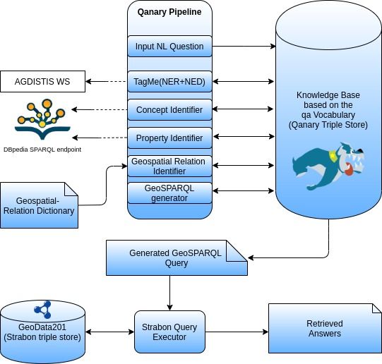
5. Creating a Geospatial Question Answering Pipeline
We now present our approach to translating a natural language question into a GeoSPARQL
query that can be executed on the union of the datasets presented in the previous section. For
this, we build a geospatial question answering system using Qanary [25] and Frankenstein [9].
5.1. The Frankenstein Framework for Building QA Systems
Qanary is a lightweight component-based QA methodology for the rapid engineering of QA
pipelines [8, 26]. Frankenstein [9] is the most recent implementation of the ideas of Qanary; this
makes it an excellent framework for developing reusable QA components and integrating them in
QA pipelines. Frankenstein is built using the Qanary methodology developed by Both et al. [8]
and uses standard RDF technology to wrap and integrate existing standalone implementations
of state-of-the-art components that can be useful in a QA system. The Qanary methodology is
driven by the knowledge available for describing the input question and related concepts during
the QA process. Frankenstein uses an extensible and flexible vocabulary [7] for data exchange
between the different QA components. This vocabulary establishes an abstraction layer for the
communication of QA components. While integrating components using Frankenstein, all the
knowledge associated with a question and the QA process is stored in a process-independent
knowledge base using the vocabulary. Each component is implemented as an independent micro-
service implementing the same RESTful interface. During the start-up phase of a QA pipeline, a
service registry is automatically called by all components. As all components are following the
same service interface and are registered to a central mediator, they can be easily activated and
combined by developers to create different QA systems.
5.2. GeoQA: A Geospatial QA System
In our work, we leverage the power of the Frankenstein framework to create QA components
which collectively implement the geospatial QA pipeline of GeoQA. The QA process of GeoQA
uses the following modules implemented as components in the Frankenstein framework: depen-
dency parse tree generator, concept identifier, instance identifier, geospatial relation identifier,
property identifier, SPARQL/GeoSPARQL query generator and SPARQL/GeoSPARQL query
executor. Our components are fully integrated in the Frankenstein ecosystem and can be reused
to implement geospatial features in other QA systems, as our implementation is not monolithic
26 http://geoqa.di.uoa.gr/benchmarkquestions.html
11Figure 1: The conceptual architecture of the GeoQA system
like the implementation of many other QA systems [27, 28, 29]. GeoQA takes as input a ques-
tion in natural language (currently only English is supported) and the three linked geospatial
datasets presented in Section 3, and produces one or more answers that are resources of the given
datasets. Question answering is performed by translating the input question to a set of SPARQL
or GeoSPARQL queries, ranking these queries, and executing the top ranked query over two end-
points using the SPARQL SERVICE keyword. For DBpedia, we use its public Virtuoso endpoint27
while for GADM, OSM and their interlinking dataset we use a Strabon endpoint. In Figure 1,
we present the conceptual view of the implemented GeoQA system and Figure 2 presents how
our system is actually implemented. The various components of GeoQA are discussed below.
Dependency parse tree generator. This component carries out part-of-speech tagging and gen-
erates a dependency parse tree for the input question using the Stanford CoreNLP software. The
dependency parse tree is produced in CoNLL-U format [30].
Concept identifier. The concept identifier module identifies the types of features specified by
the user in the input question and maps them to the corresponding classes in the DBpedia,
GADM and OSM ontologies. We use the equivalent ontology-oriented term concept for a fea-
ture type in this paper. For example, if the input question is “Which restaurants are near Big
Ben in London?”, then the term “restaurants” is identified as a feature type and mapped to the
class osmo:Restaurant in the OSM ontology and dbo:Restaurant in the DBpedia ontol-
ogy. The matching classes are found using string matching on the labels of the classes (the Java
library function java.util.regex.Pattern.matcher()is used)together with lemmatization
from Stanford CoreNLP and synonyms from Wordnet. In its final stage, the concept identifier
annotates the appropriate node of the dependency parse tree with its results.
27 http://dbpedia.org/sparql
12Table 3: Accuracy of various named entity recognizer and disambiguator over Geoquestion201
Accuracy over
NER+NED tool Disambiguate to
GeoQuestions201(%)
StanfordNER [32] + AIDA [33] 80.0 Wikipedia
DBpedia Spotlight [34] 79.22 DBpedia
StanfordNER [32] + AGDISTIS [35] 81.50 DBpedia
TagMe [31] 89.5 Wikipedia
MeaningCloud29 67.0 Wikipedia
TextRazor30 76.5 Wikipedia
Babelfly [36] 40.5 DBpedia
Entity-fishing31 84.5 Wikipedia
Instance identifier. The next useful information to be identified in an input question is the fea-
tures mentioned. These can be e.g., the country Ireland or the city Dublin or the river Shannon
etc. We use the equivalent ontology-oriented term instance(s) for features in this paper. Once
instances are identified, they are mapped to DBpedia, OSM or GADM resources using the entity
recognition and disambiguation tool TagMeDisambiguate [31]28 .
Let us explain why we selected TagMeDisambiguate. We have considered the tools that have
been used in [9] for entity recognition and disambiguation. We have tested these tools over
GeoQuestions201. It is to keep in mind that these tools may or may not be targeted for short text
and text documents. We have used web services of these tools to annotate the GeoQuestions201.
Table 3 shows information on these tools with how they perform over GeoQuestion201. Column
accuracy in Table 3 is percentage of questions from the 201 we have that are correctly annotated
with entities and their instances from DBpedia, Wikipedia or Wikidata.
The annotations from each tool were verified manually. As can be seen in Table 3, TagMeDis-
ambiguate annotates most of the questions correctly compared to other tools.
We also search for resources in the OSM and GADM dataset that have the same label as the
entity identified by the TagMeDisambiguate component, and add them to the list of identified in-
stances. For illustration, consider the input question “Which airports are in London?”. The term
“London” is the identified instance (feature) and it is disambiguated to the wikipedia link and we
get DBpedia resource dbr:London by owl:sameAs link from DBpedia Virtuoso endpoint32 , and
to osmr:england/places/id/107775 and gadmr:administrativeUnit_GBR_adm2_56 by
our code. In its final stage, the instance identifier annotates the appropriate node of the depen-
dency parse tree with its results.
Geospatial relation identifier. Geospatial questions such as the ones targeted by GeoQA almost
always include a qualitative geospatial relation such as “borders” or a quantitative one such as
“at most 2km from”. The current implementation supports the 14 geospatial relations shown
on Table 4. These include some topological, some distance and some cardinal direction rela-
tions [37, 38, 39]. Table 5 gives a dictionary of the various synonyms for these relations that can
appear instead of them in a question. The semantics of topological relations are as in the dimen-
sionally extended 9-intersection model [40]. Qualitative spatial relations of proximity like “close
28 https://tagme.d4science.org/tagme/
32 http://dbpedia.org/sparql
13Table 4: Geospatial relation categories and relations
Category Geospatial relation
Topological relations “within”, “crosses”, “borders”
Distance relations “near”, “at most x units”, “at least x units”
“north of”, “south of”, “east of”, “west of”, “northwest
Cardinal direction relations
of”, “northeast of”, “southwest of”, and “southeast of”
to", “near" etc. are translated into (rather arbitrary) quantitative distance relations based on the
concept identified earlier by the concept identifier (e.g., when asking for “hotels near a place",
“near” is taken to mean at most 1 kilometer). The semantics of cardinal direction relations are
the usual ones i.e., a relation A north of B is given meaning by considering the bounding box of
the reference region B and the partition of the plane in nine areas that is induced by it [39]. The
same semantics are implemented by the Strabon system and its query language stSPARQL which
is used as our back end geospatial RDF store [4]. GeoSPARQL does not support any cardinal
direction functions or relations. Finally, Kreveld and Reinbacher [41] provide a more intuitive
semantics of cardinal directions for polygons, but an implementation of this semantics is more
expensive computationally than the semantics used in Strabon [4].
Like the previous modules, this module first identifies geospatial relations in the input ques-
tion, and then maps them to a spatial function of the GeoSPARQL or stSPARQL vocabulary, or
a data property with a spatial semantics in the DBpedia ontology. As we have already discussed
in the introduction, DBpedia contains limited explicit or implicit geospatial knowledge using lat-
itude/longitude pairs, and properties such as dbp:northeast for cardinal direction relations or
class-specific properties such as dbo:city (e.g., for class dbr:River). GeoQA does not make
use of quantitative geospatial information (i.e., latitude/longitude pairs) from DBpedia since we
have more detailed geospatial knowledge in the form of polygons in the datasets GADM and
OSM. However, it does makes use of qualitative geospatial knowledge from DBpedia expressed
using the data properties just mentioned (although this knowledge is rather scarce as discussed
in [42]). As an example, for the question “Which counties border Lincolnshire?”, the geospatial
relation “borders” is identified from the verbs in the dependency tree, and it is mapped to the
spatial function geof:sfTouches of the GeoSPARQL vocabulary.
In its final stage, the geospatial relation identifier annotates the appropriate node of the depen-
dency parse tree with its results. In the near future, GeoQA will cover all the prototypical spatial
relations shown experimentally to correspond to natural language utterances by Egenhofer, Mark
and their colleagues in [43, 44, 45].
Property Identifier. The property identifier module identifies attributes of types of features and
attributes of features specified by the user in input questions and maps them to corresponding
properties in DBpedia. To answer questions like “Which rivers in Scotland have more than 100
km length?” or “Which mountains in Scotland have height more than 1000 meters?”, we need
information about length of rivers and height of the mountains in addition to their geometry
from OSM. This information is not present in OSM but we can retrieve this information from
DBpedia. We use Table 6 and 7 for this task. The identified concept from the concept identifier
module is used to search Table 6 to get dbp:height and dbp:length in the case of example
questions mentioned before. In case of question “Which Greek restaurants in London are near
Wembley stadium?”, it is to be inferred that Greek should be a cuisine in context of restaurants
14Table 5: Geospatial relations and their synonyms
Geospatial relation Synonyms in dictionary
within in, inside, is located in, is included in
crosses cross, intersect
near nearby, close to, around
is/are at the border of, is/are at the outskirts of, at the boundary
borders
of
north of above of
south of below
east of to the right
west of to the left
Table 6: DBpedia Properties
DBpedia
DBpedia Property Label of property
Class
Mountain http://dbpedia.org/property/height Height
Mountain http://dbpedia.org/property/elevation elevation
Mountain http://dbpedia.org/property/parentPeak Parent peak
River http://dbpedia.org/property/length length
River http://dbpedia.org/property/name name
River http://dbpedia.org/property/dischargeLocation discharge location
River http://dbpedia.org/property/mouth Mouth
and we need to check all the possible values of properties for the identified concept. We achieve
this with the use of Table 7. We stress that Tables 6 and 7 contain only examples of classes,
properties and values that are of interest to the example questions. In reality the tables contain
11,392 and 2,61,455 entries respectively and cover all the DBpedia classes of Table 2. These
tables have been generated querying DBpedia and stored in different files with their class names.
In similar manner for question like “What is the total area of Northern Ireland?” we query
DBpedia endpoint to retrieve property dbp:areaKm that is present in DBpedia for identified
instance dbr:Northern_Ireland. We use string similarity measures while searching Table 6
and pattern matching while searching Table 7. In its final stage, the property identifier annotates
the appropriate node of the dependency parse tree with its results.
Table 7: DBpedia Properties and Values
DBpedia Class DBpedia Property Value of property
Restaurant http://dbpedia.org/ontology/cuisine Asian Cuisine
Restaurant http://dbpedia.org/ontology/cuisine Italian,pizzeria
Italian, Greek,
French, Spanish,
Restaurant http://dbpedia.org/ontology/cuisine
and Creole table
delicacies
15Listing 1: SPARQL/GeoSPARQL Query for Motivating Example 1
Question: Which rivers cross Limerick?
SPARQL:
select ?x
where {
?x rdf:type dbo:River.
?x dbo:city dbr:Limerick.
}
GeoSPARQL:
PREFIX geo:
PREFIX geof:
PREFIX osmo:
select ?x
where {
?x rdf:type osmo:River;
geo:hasGeometry ?xGeom.
?xGeom geo:asWKT ?xWKT.
gadmr:Limerick geo:hasGeometry ?iGeom.
?iGeom geo:asWKT ?iWKT.
FILTER(geof:sfCrosses(?xWKT, ?iWKT))
}
Query generator. This module creates a SPARQL or a GeoSPARQL query using handcrafted
query templates. From gathering questions from Google Trends
and also studying the questions in our gold standard, we have identified the question pat-
terns shown in Tables 8 and 9. In these tables C stands for “concept”, I for “instance” , R for
“geospatial relation” , P for “property” and N for “Count of” following the terminology we have
introduced above. For each pattern, the tables give an example question and the corresponding
GeoSPARQL and/or SPARQL query template. The query templates contain slots (strings start-
ing with an underscore) that can only be identified when an example question is encountered and
will be completed by the query generator (see below).
For each input question, the slots in the template are replaced by the query generator with
the output of the previous modules, to generate a SPARQL or a GeoSPARQL query. For
example, for the question “What is length of the river that crosses Limerick?”, the identi-
fied pattern is PCRI. The question pattern is identified by searching the dependency parse
tree in which the nodes have been annotated with the results of the concept, instance, prop-
erty and geospatial relation identifier modules presented above. We walk through the parse
tree with inorder traversal and identify the question pattern. If the question does not fol-
low any of the patterns, a message is passed to the next component that no query has been
generated. The appropriate templates are selected from Table 8 and 9, their slots are filled
with the resources identified earlier and the corresponding GeoSPARQL or SPARQL queries
are generated. Here the concepts are dbr:River from DBpedia and osmo:River from
OSM, the property is dbp:length from DBpedia, the instances are gadmr:Limerick from
GADM and osmo:irelandandnorthernireland/places/id/2518952 from OSM, and the
16Table 8: Supported question patterns with examples and corresponding SPARQL/GeoSPARQL query templates for
categories 1-5
Example natural
Pattern Templates
language question
SPARQL:
Where is Emirates select ?x where {
IP
Stadium located? _Instance _Property ?x.
}
SPARQL:
select ?x where {
?x rdf:type _Concept.
?x _Relation _Instance.
}
GeoSPARQL v1:
select ?x where {
?x rdf:type _Concept; geo:hasGeometry ?xGeom.
?xGeom geo:asWKT ?xWKT.
_Instance geo:hasGeometry ?iGeom. ?iGeom geo:asWKT ?iWKT.
Which rivers cross
CRI FILTER(_Relation(?xWKT, ?iWKT))
Limerick?
}
GeoSPARQL v2:
select ?x where {
?x rdf:type _Concept;
geo:hasGeometry ?xGeom.
?xGeom geo:asWKT ?xWKT.
?instance owl:sameAs _Instance; geo:hasGeometry ?iGeom.
?iGeom geo:asWKT ?iWKT.
FILTER(_Relation(?xWKT, ?iWKT))
}
select ?x where {
?x rdf:type _Concept; geo:hasGeometry ?xGeom.
?xGeom geo:asWKT ?xWKT.
Which churches are _Instance1 geo:hasGeometry ?i1Geom.
CRIRI close to the Shannon ?i1Geom geo:asWKT ?i1WKT.
in Limerick? _Instance2 geo:hasGeometry ?i2Geom.
?i2Geom geo:asWKT ?i2WKT.
FILTER(_Relation1(?xWKT, ?i1WKT) && _Relation2(?i1WKT, ?i2WKT) )
}
select ?x where {
?x rdf:type _Concept1; geo:hasGeometry ?xGeom.
?xGeom geo:asWKT ?xWKT.
Which restaurants
CRC ?y rdf:type _Concept2; geo:hasGeometry ?yGeom.
are near hotels?
?yGeom geo:asWKT ?yWKT.
FILTER(_Relation(?xWKT, ?yWKT))
}
select ?x where {
?x rdf:type _Concept1; geo:hasGeometry ?xGeom.
?xGeom geo:asWKT ?xWKT.
?y rdf:type _Concept2; geo:hasGeometry ?yGeom.
Which restaurants
?yGeom geo:asWKT ?yWKT.
CRCRI are near hotels in
_Instance geo:hasGeometry ?zGeom.
Limerick? 17
?zGeom geo:asWKT ?zWKT.
FILTER(_Relation1(?xWKT, ?yWKT) && _Relation2(?xWKT, ?zWKT) &&
_Relation2(?yWKT, ?zWKT)
}
ASK where {
_Instance1 geo:hasGeometry ?iGeom1.
?iGeom1 geo:asWKT ?iWKT1.
Is Hampshire north
IRI _Instance2 geo:hasGeometry ?iGeom2.
of Berkshire?
?iGeom2 geo:asWKT ?iWKT2.
FILTER(_Relation(?iWKT1, ?iWKT2))
}Table 9: Supported question patterns with examples and corresponding SPARQL/GeoSPARQL query templates for
categories 6,7
Example natural
Pattern Templates
language question
SPARQL:
select (count(distinct ?x) as ?total) where {
?x rdf:type _Concept.
?x _Relation _Instance.
}
GeoSPARQL v1:
select (count(distinct ?x) as ?total) where {
?x rdf:type _Concept; geo:hasGeometry ?xGeom.
?xGeom geo:asWKT ?xWKT.
_Instance geo:hasGeometry ?iGeom. ?iGeom geo:asWKT ?iWKT.
How many hospitals
NCRI FILTER(_Relation(?xWKT, ?iWKT))
are there in Oxford?
}
GeoSPARQL v2:
select (count(distinct ?x) as ?total) where {
?x rdf:type _Concept;
geo:hasGeometry ?xGeom.
?xGeom geo:asWKT ?xWKT.
?instance owl:sameAs _Instance; geo:hasGeometry ?iGeom.
?iGeom geo:asWKT ?iWKT.
FILTER(_Relation(?xWKT, ?iWKT))
}
SPARQL:
select ?property where {
?x rdf:type _Concept.
?x _Relation _Instance.
?x _Property ?property.
}
GeoSPARQL :
What is the length of select ?property where {
PCRI the river that crosses SERVICE {
Limerick? ?x rdf:type _Concept; geo:hasGeometry ?xGeom.
?xGeom geo:asWKT ?xWKT.
_Instance geo:hasGeometry ?iGeom.
?iGeom geo:asWKT ?iWKT.
?x owl:sameAs ?dbpediaLink. FILTER(_Relation(?xWKT, ?iWKT)) }
SERVICE {
?dbpediaLink _Property ?property }
}
GeoSPARQL :
select ?property where {
SERVICE {
?x rdf:type _Concept; geo:hasGeometry ?xGeom.
?xGeom geo:asWKT ?xWKT.
What is the name
_Instance1 geo:hasGeometry ?i1Geom.
of the river that
?i1Geom geo:asWKT ?i1WKT.
PCRIRI flows under the
_Instance2 geo:hasGeometry ?i2Geom.
Queensway Bridge
?i2Geom geo:asWKT ?i2WKT.
in Liverpool? 18
?x owl:sameAs ?dbpediaLink.
FILTER(_Relation1(?xWKT, ?i1WKT)) && _Relation2(?i1WKT, ?i2WKT) }
SERVICE {
?dbpediaLink _Property ?property }
}Listing 2: SPARQL/GeoSPARQL Query for Motivating Example 2
Question: How many hospitals are there in Oxford?
SPARQL:
select (count(distinct ?x) as ?total)
where {
?x rdf:type dbo:Hospital.
?x dbp:locatedIn dbr:Oxford.
}
GeoSPARQL:
PREFIX geo:
PREFIX geof:
PREFIX osmo:
select (count(distinct ?x)as ?total)
where {
?x rdf:type osmo:Hospital;
geo:hasGeometry ?xGeom.
?xGeom geo:asWKT ?xWKT.
gadmr:Oxford geo:hasGeometry ?iGeom.
?iGeom geo:asWKT ?iWKT.
FILTER(geof:sfWithin(?xWKT, ?iWKT))
}
geospatial relations are dbo:city from the DBpedia ontology and the GeoSPARQL function
geof:sfCrosses.
The row of Table 8 for pattern CRI contains two GeoSPARQL queries (v1 and v2). The sec-
ond query is for the case when the identified instance is a DBpedia resource for which geometry
information is available in GADM or OSM. In addition to that, the rows for the patterns PCRI and
PCRIRI in Table 9 contains a service tag for a GeoSPARQL query in order to fetch information
from two different endpoints to execute the query. This query is for the case when the identi-
fied instance is a DBpedia resource for which geometry information is available in OSM while
attributes like dbp:length or dbp:height are in DBpedia. This is where the owl:sameAs
sentences produced by our interlinking process discussed in Section 3 are used. Listing 3 and
Listing 4 show examples of these cases. Similar templates exist for all the other patterns.
Because we want to increase recall, our strategy is to use more than one component of Geo-
Data201 for answering a question. For example, for the question “Which towns in England are
east of Manchester?” DBpedia gives us 3 answers (Glossop, Stallybridge and Hyde) while OSM
gives us 1626 towns. Our strategy for increasing precision is to have the query generator take
into account class and property information from the ontologies of the three datasets. This is
illustrated by the SPARQL query in Listing 1 where we make use of the fact that the property
dbo:city is used in DBpedia to refer to the cities crossed by a river. To implement this strategy
we keep a table with three columns which contains triples of the form domain-property-range
for each property in the dataset GeoData201. Some example rows can be seen in Table 10. This
approach has also been taken in [15].
The last job of the query generator is to rank the generated queries. Query ranking is a
19Listing 3: GeoSPARQL Query for Motivating Example 3
Question:Which forest is near Manchester?
GeoSPARQL:
PREFIX owl:
PREFIX geo:
PREFIX geof:
PREFIX osmo:
select ?x
where {
?x rdf:type osmo:Forest;
geo:hasGeometry ?xGeom.
?xGeom geo:asWKT ?xWKT.
?instance owl:sameAs dbr:Manchester;
geo:hasGeometry ?iGeom.
?iGeom geo:asWKT ?iWKT.
FILTER(geof:distance(?xWKT,?iWKT,uom:metre)Listing 4: SPARQL/GeoSPARQL Query for Motivating Example 4
Question:What is the length of the river that crosses Limerick?
SPARQL:
select ?length
where {
?x rdf:type dbo:River.
?x dbo:city dbr:Limeric.
?X dbp:length ?length.
}
GeoSPARQL:
PREFIX geo:
PREFIX geof:
PREFIX osmo:
select ?length
where {
SERVICE
{
?x rdf:type osmo:River;
geo:hasGeometry ?xGeom;
owl:sameAs ?dbpediaLink.
?xGeom geo:asWKT ?xWKT.
gadmr:Limerick geo:hasGeometry ?iGeom.
?iGeom geo:asWKT ?iWKT.
FILTER(geof:sfCrosses(?xWKT, ?iWKT))
}
SERVICE
{
?dbpediaLink dbp:length ?length
}
}
crucial component of a question answering system. In the current version of GeoQA, we use a
very simple heuristic for the ranking of generated queries based on the estimated selectivity of
the generated queries. We compute the selectivity of a SPARQL or GeoSPARQL query taking
into account only the triple patterns present in the query and using the formulas of [46]. The
generated query with the lowest selectivity is selected to be executed; in this way, we expect to
generate more results to the user question.
Expressive Power of Patterns.. It is interesting to consider the expressive power of patterns in
Tables 8 and 9 by giving a corresponding binary first-order logic formula.33 Questions fol-
lowing pattern IP can be written as x : P(I, x). Questions following the CRI pattern can be
33 In the following formulas, we assume that identifiers (i.e., geographic features) are denoted by constants, concepts
(i.e., classes of features) by unary predicates and geospatial relations by binary predicates. Constants and predicates are
denoted by capital letters while variables are denoted by lowercase letters. Variables are assumed to range over identifiers
with the exception of variable v in the case pf PCRI which ranges over values. The “:” symbol should be read as “such
that”.
21You can also read