A MOBILE PLATFORM FOR MEASURING AIR POLLUTION IN CITIES USING GAS SENSORS - DIVA PORTAL
←
→
Page content transcription
If your browser does not render page correctly, please read the page content below
EXAMENSARBETE INOM TEKNIKOMRÅDET
INFORMATIONSTEKNIK
OCH HUVUDOMRÅDET
INFORMATIONS- OCH KOMMUNIKATIONSTEKNIK,
AVANCERAD NIVÅ, 30 HP
STOCKHOLM, SVERIGE 2018

A Mobile Platform for Measuring
Air Pollution in Cities using Gas
Sensors

MIKAEL MÖLDER

KTH
SKOLAN FÖR ELEKTROTEKNIK OCH DATAVETENSKAP
Abstract
Although air pollution is one of the largest threats to human health, the data
available to the public is often sparse and not very accurate nor updated. For
example, there exists only about 5-10 air quality measuring points across the
city of Stockholm. This means that the available data is good in close
proximity of the sensing equipment but can differentiate much only a couple
of blocks away. In order for individuals to receive up to date information
around a larger city, stationary measurements are not sufficient enough to get
a clear picture of how the current state of the air quality stands. Instead, other
methods of collecting this data is needed, for instance by making the
measurements mobile.

GOEASY is a project financed by the European Commission where Galileo,
Europe’s new navigational service, is used to enable more location-based
service applications. As part of the GOEASY project is the evaluation of the
potential of collaborative applications where users are engaged to help
individuals affected by breathing-related diseases such as asthma. This thesis
presents the choice of architecture and the implementation of a mobile
platform serving this purpose. Using sensors mounted on a range of objects
real time air quality data is collected and made available.

The result is a mobile platform and connected Android application which by
utilizing air quality sensors, reports pollution measurements together with
positional coordinates to a central server. Thanks to the features of the
underlying systems used, this provides a platform which is accurate and more
resilient to exploits compared to traditional location-based services available
today. The result allows individuals with respiratory conditions to receive
much more accurate and up to date information in a larger resolution. It also
serves the purpose of demonstrating the potential of the supporting
technology as part of the GOEASY project.

Keywords
Air quality, Sensors, Location Based Services, Galileo, Android
application, Raspberry Pi

Abstract
Trots att föroreningar i luften är bland de största hoten mot mänsklig hälsa är
den information som finns tillgänglig för allmänheten ofta både gles och inte
tillräckligt noggrann eller uppdaterad. Till exempel finns det i hela
Storstockholm endast mellan 5–10 luftkvalitetstationer som mäter
föroreningar. Detta innebär att den data som finns tillgänglig är bra i närheten
av mätutrustningen men kan skilja sig mycket enbart ett par kvarter bort. För
att öka mängden information som är tillgänglig till allmänheten räcker inte
längre enbart de stationära lösningarna som finns idag för att visa hur de
rådande halterna av föroreningar står sig. Andra metoder måste införas,
exempelvis genom att nyttja mobila mätningar från en plattform som kan röra
sig fritt.

GOEASY är ett projekt finansierat av den Europeiska Kommissionen, där
Galileo, Europas nya navigationssystem används för att tillåta fler
platsbaserade tjänster att äntra marknaden. Som en del av GOEASY projektet
ingår evalueringen av potentialen i en applikation där användare samlar in
data för att hjälpa individer med andningssvårigheter som astma. Denna
avhandling presenterar valen till arkitekturen samt implementationen av en
mobil plattform som en del av GOEASY. Lösningen använder sig av mobila
luftkvalitetsensorer som kan monteras på en rad olika objekt som samlar data
i realtid som görs tillgänglig för allmänheten.

Resultatet är en mobil plattform och tillhörande Android applikation som
med hjälp av luftkvalitetsensorer rapporterar halten av olika skadliga
föroreningar tillsammans med platsinformation till en central server. Tack
vare egenskaperna av de underliggande systemen som används, skapas en
plattform som är mycket mer precis när det gäller positionering jämfört med
liknande system som finns tillgängligt. Det resulterande systemet gör det
möjligt för individer med andningssvårigheter att få tillgång till noggrannare
samt mer uppdaterad information i större utsträckning än vad som för
närvarande är tillgängligt. Systemet fyller även syftet med att demonstrera
potentialen i den bakomliggande teknologin som en del av GOEASY.

Nyckelord
Luftkvalitet, Sensorer, Platsbaserade tjänster, Galileo, Android
applikation, Raspberry Pi
Acknowledgements
First, I would like to thank CNet Svenska AB and Peter Rosengren for giving
me the opportunity to conduct my master thesis together with them and
providing me the project. Thank you to my examiner Anne Håkansson and
supervisor Vladimir Vlassov for giving valuable feedback during the course of
the project and guiding me through the process.

A special thank you to Araxi Mekhitarian and Felicia Schnell for continuously
reading my thesis and helping me structure it to what it is today. Their
feedback and comments have been valuable additions to the work which could
easily not been identified otherwise.
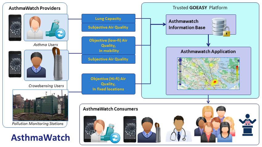
Table of Contents
1 Introduction ........................................................................................................... 1
1.1 Background ................................................................................................................ 1
1.2 Problem ....................................................................................................................... 2
1.3 Purpose........................................................................................................................ 3
1.4 Goal ............................................................................................................................... 3
1.4.1 Benefits, Ethics and Sustainability ....................................................................................... 3
1.5 Research methodology ............................................................................................ 4
1.6 Stakeholders .............................................................................................................. 6
1.7 Delimitations ............................................................................................................. 7
1.8 Outline ......................................................................................................................... 8
2 Hardware and communication technologies ................................................ 9
2.1 Single-board computers.......................................................................................... 9
2.1.1 Raspberry Pi .................................................................................................................................... 9
2.1.2 Arduino UNO ................................................................................................................................ 10
2.2 Communication protocols ....................................................................................10
2.2.1 Bluetooth ........................................................................................................................................ 11
2.2.2 MQTT ................................................................................................................................................ 11
2.3 Galileo ........................................................................................................................12
2.3.1 Atomic clocks for high accuracy ......................................................................................... 12
2.3.2 Countermeasures for spoofing ........................................................................................... 13
3 Measuring air quality ......................................................................................... 15
3.1 Different types of pollutants................................................................................15
3.1.1 Particulate Matter...................................................................................................................... 15
3.1.2 Ground level Ozone................................................................................................................... 16
3.1.3 Nitrogen Dioxide ........................................................................................................................ 16
3.1.4 Summary Air Pollutants ......................................................................................................... 16
3.2 Sensing the air .........................................................................................................17
3.2.1 Electrochemical sensing ......................................................................................................... 17
3.2.2 Spectroscopy ................................................................................................................................ 17
3.2.3 Ionization ....................................................................................................................................... 18
3.3 Air Quality Index .....................................................................................................18
3.3.1 United States AQI ....................................................................................................................... 18
3.3.2 AQI in Europe ............................................................................................................................... 19
3.4 Related work ............................................................................................................20
3.4.1 Participatory networks ........................................................................................................... 20
3.4.2 Personal air quality tracker .................................................................................................. 21
4 Methodology ......................................................................................................... 22
4.1 Data collection methods .......................................................................................22
4.1.1 Document study.......................................................................................................................... 22
4.1.2 Interviews ...................................................................................................................................... 23
4.2 Work process ...........................................................................................................23
4.2.1 System requirements ............................................................................................................... 24
4.2.2 Software development method .......................................................................................... 24
4.2.3 Testing ............................................................................................................................................. 25
5 Development of a mobile platform ................................................................ 27
5.1 Collection of requirements ..................................................................................27
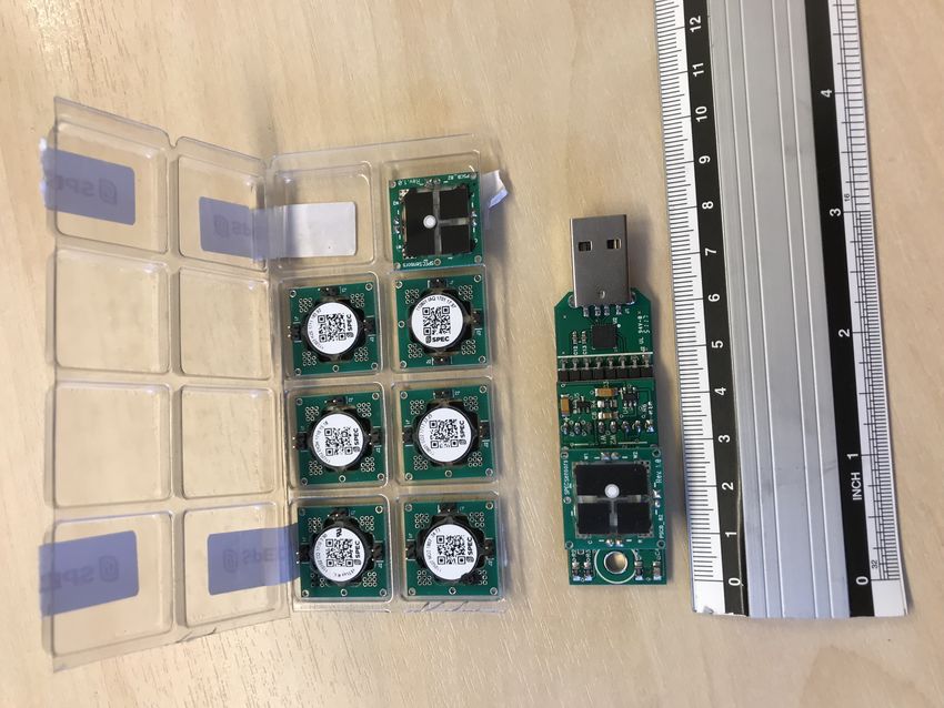
5.2 Choosing components............................................................................................285.2.1 Sensors ............................................................................................................................................ 29
5.2.2 Platform .......................................................................................................................................... 30
5.2.3 Smartphone for missing functionality ............................................................................ 31
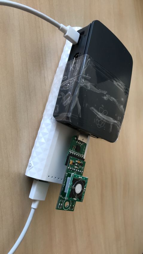
5.3 Implementation of the mobile platform...........................................................32
5.3.1 Measuring gases in the air..................................................................................................... 32
5.3.2 Bluetooth on the Raspberry Pi ............................................................................................ 34
5.4 Android application ...............................................................................................35
5.4.1 Application basics ...................................................................................................................... 35
5.4.2 Android Bluetooth ..................................................................................................................... 35
5.4.3 Obtaining locational data ....................................................................................................... 36
5.4.4 Generating MQTT payload .................................................................................................... 36
5.5 Storage solution ......................................................................................................38
6 A mobile platform for sensing air pollution ................................................ 40
6.1 The mobile platform ..............................................................................................41
6.2 Application ...............................................................................................................42
6.3 Evaluation .................................................................................................................44
6.3.1 Results of unit-tests .................................................................................................................. 44
6.3.2 Accuracy of sensors .................................................................................................................. 45
6.3.3 Determining position ............................................................................................................... 47
6.3.4 Power consumption.................................................................................................................. 49
6.3.5 Fulfilment of requirements................................................................................................... 49
7 Conclusions and future work ........................................................................... 52
7.1 Discussion .................................................................................................................53
7.2 Future work..............................................................................................................54
References ..................................................................................................................... 56LIST OF ABBREVIATIONS
APL Arduino Programming Language
AQI Air Quality Index
CAQI Common Air Quality Index
CO Carbon Monoxide
DoA Designation of Authority
EC European Commission
ESA European Space Agency
EPA Environmental Protection Agency
GNSS Global Navigation Satellite System
GOEASY GalileO-based trustEd Applications for health and
SustainabilitY
GPIO General Purpose Input Output
GPS Global Positioning System
GSA GNSS Agency
GSM Groupe Spécial Mobile – mobile network communication
GUI Graphical User Interface
I/O Input/Output
IoT Internet of Things
JSON JavaScript Object Notation
LAN Local Area Network
LIBS Laser-induced Breakdown Spectroscopy
MQTT Message Queueing Telemetry Transport
NO2 Nitrogen Dioxide
O3 Ozone
OGC Open Geospatial Consortium
PHM Passive Hydrogen Maser
PM Particulate Matter
PPB Parts Per Billion
PRS Public Regulated Service
RAFS Rubidium Atomic Frequency Standard
RFCOMM Bluetooth protocol used for transporting messagesSA Selective Availability SBC Single Board Computer SDK Standard Development Kit SO2 Sulphur Dioxide UART Universal Asynchronous Receiver/Transmitter VOC Volatile Organic Compounds WHO World Health Organisation XML Extensible Markup Language
1 Introduction
The World Health Organization (WHO) published a report in 2016 [1], where
air pollution was pointed out as the biggest environmental risk to human
health, responsible for one of nine deaths annually. In addition, only about
one in ten live in a city with acceptable levels of air pollution according to
WHO’s guidelines. As a result, the amount of cases of heart diseases, lung
cancer and respiratory diseases like asthma has shown a large increase and
can be directly connected to the emissions of harmful particles in the air [2].

While air pollution poses such a threat, information about the current
pollution levels throughout cities is not sufficient when it comes to availability
and accuracy. As an example, in the entire city of Stockholm there only exists
about 5-10 stationary measuring points [3]. Due to the non-linearity of
locations’ pollution levels, the measurements are valid in close proximity of
the sensing equipment but differs as the distance increases [4]. In order to
enable more data to be publicly available, new and cheaper means must be
deployed, where one potential solution is the use of small sensors attached to
a mobile platform.

In recent years the number of devices using positioning information has
shown an exponential growth, and by 2019 it is expected that each person on
the planet owns at least one such device on average [5]. This trend opens up
opportunities in the market for the adoption of a new type of position
technology. One such technology is Galileo [6], Europe’s new navigational
system, offering better precision and disabling the possibility to fake the users
location compared to traditional positioning systems, making it an attractive
alternative. By increasing the number of air quality measurements and
combining the collected data with accurate navigational data, a system which
is more robust and accurate than those available today can be achieved.

1.1 Background
With new technology constantly emerging on the market, advances in mobile
alternatives of hardware are made [7]. This allows companies to build more
compact solutions of their products, containing more features than previously
possible. One sector where this trend is especially prominent is wearable
technology in the form of sensors and micro-computers, where applications in
health among others are especially prominent.

There exists a wide range of sensors which are small and flexible enough to be
attached to the skin or integrated in devices able to be carried around [8]. For
example, optical sensors can be used in contact with human skin to measure
heartrate and other vital signs, and by using optical-chemical sensors which,
in contact with sweat, makes it possible to measure blood glucose levels.
Different types of sensors exist everywhere, not to mention a typical
smartphone which contains a number of sensors used by applications and
services to provide functionality [9]. Some of these sensors include; an
accelerometer used to determine the orientation of the device, a proximity
                                                                                1
sensor used to turn off the screen when holding the device to your ear, an
ambient light sensor used to automatically adjust the brightness of the screen
and a navigation sensor for determining location data only naming a few [10].
The growing number of connected sensors and other devices has coined the
umbrella term “Internet of Things” (IoT) referencing otherwise disconnected
physical items being extended to the real world and made available via the
Internet [11]. The keyword in IoT is “smart” describing an object which by
observing its surrounding, generates data to be processed. IoT does not
consist of one single protocol or technology but rather a collection of several
communication protocols, sensors and user interfaces depending on the
application. This enables the developer to make decisions about what is most
compatible for the current context.
Today, connected IoT products exist everywhere from coffee machines and
washing machines, which can be monitored and controlled wirelessly via an
application, to small sensors notifying when the flowers need watering by
turning on a light [12]. This has allowed many new applications and products
to emerge on the market but has also increased the load on networks by
introducing large quantities of new traffic and data. In a forecast made by
Ericsson in 2016 [13], it was predicted that the number of connected IoT
devices will surpass mobile phones during 2018. It was also predicted that by
2022, 70% of the wide-area network devices (devices not connected to a fixed
local area network) would use cellular technology instead of relying on WiFi or
other close-range communication.
When developing new devices which play a part in the large ecosystem of
connected devices, it is important to think about everything from how
messages are communicated, the cost and size of hardware and energy
consumption in order to create products which are sustainable and durable.
With this in mind, design decisions can be made accordingly to create
something positively beneficial for society. One example is using small sensors
which measures the levels of air pollution in the air and sends them wirelessly
to be made available for different applications.
1.2 Problem
Finding good areas of operation, where available hardware and products can
be used to benefit a large group of people, can be difficult. One approach is to
investigate areas where there currently exist a shortage of available
information or data. Measuring air pollution throughout cities fits this
description well, since information regarding air quality available to the public
is currently lacking by not being accurate nor available. In some noted cases
such as [14], information published by two different sources regarding the
pollution levels show completely different results, one reporting the situation
as moderate when the other classified it as unhealthy.
While humans are suffering from increased levels of pollutants in the air,
there are far more problems which they bring, as mentioned by E. Lanzi et al.
2[15]. On top of causing diseases and premature deaths, the environment
suffers at least as much with a lowered crop yield, groundwater pollution and
degradation of buildings. What both problem areas have in common is the
economic impact it brings by putting a higher demand on healthcare and
destroying crops and other produce. This points to the fact that making
information about the levels of pollutants in the air available is both necessary
and vital in order to make people more aware of the current situation.
Furthermore, by looking at an existing infographic map displaying the air
quality index (AQI) across the world such as [16], one can easily note the
sparsity of the measurements available. The lack of air quality measurements
across the world makes it problematic for asthma patients to avoid polluted
areas without knowing near real time air quality data, severely increasing the
risk of suffering from an attack. Improving the number of measuring points by
capturing sensor readings using a mobile platform, complementing the
already existing sources, would allow for accurate near real-time
measurements from locations previously not available.
The problems presented leads to the research question which underlies the
thesis:
How can a mobile platform, using sensors, increase the
availability of information and awareness of air quality in larger
cities?
1.3 Purpose
The purpose of the thesis is to present an implementation and evaluation of a
mobile platform which by using connected sensors collects air quality data.
The data can then be made available for the public where primarily people
suffering from respiratory diseases can benefit from up to date information
about air quality. The purpose of the work is to investigate different available
technologies which can be applied in the system and to develop a proof-of-
concept prototype.
1.4 Goal
The goal of the project is to provide the society with a mobile platform which
makes information about air quality available. This will allow individuals
suffering from respiratory diseases to stay informed about the current state of
the air around them. By deploying the platform, anyone interested can
contribute to it by walking around with a connected sensor. Using the help of
Galileo navigation [17], the measurements are more accurate when it comes to
location compared to any similar existing solution.
1.4.1 Benefits, Ethics and Sustainability
The benefits with developing a system which captures real time air quality
data and makes it publicly available affects both the individual person and the
society in multiple ways. With detailed up to date information, individuals
sensitive to highly polluted areas can avoid them and thereby not worsen their
3conditions. This also helps people not yet suffering from breathing related
diseases to avoid risk being affected.
Analyzing the project from the sustainability point of view, there are three
aspects which are usually considered; ecologic, economic and social
sustainability [18]. Ecological sustainability is achieved by making society
aware of the level of pollution present throughout a city. This can then trigger
more sustainable and environment-friendly behavior, by making active
choices and decisions that benefit the environment, also impacting social
sustainability.
Allowing society to take part of collecting and visualizing the air quality has a
positive effect on economical sustainability if knowing the air quality can
promote actions which in the long-term saves produce otherwise suffering
negatively by the pollution. Furthermore, reducing the amount of pollutants in
the air and having less people suffering from breathing related diseases as a
result will take pressure of the already heavily loaded healthcare.
When it comes to the ethical aspects of this thesis project, it is very important
that the information collected and published is as correct as possible both in
particle levels and coordinates in order to produce trustworthy data. If
readings are not accurate, this might result in negative effects by exposing
sensitive individuals to high amounts of pollution thinking it’s safe. Having
individuals help by collecting air quality data together with location might
have a negative consequence if the data can be used to track the position of a
single individual. Therefore, it is important that no unnecessary personal
information is being handled in the implemented system to prevent uninvited
behavior.
1.5 Research methodology
Multiple methodologies are available when conducting a research project and
choosing the most suitable is key to the success and quality of the finished
thesis. This is discussed by A. Håkansson in [19] where it is stated that often
the methodology for the project is chosen first after the work has been
conducted which results in having to bend the actual methods in order to suit
the work done. In some cases, new, hybrid, methods are invented to best fit
the case which does not make for a good thesis.
Two methods are commonly mentioned when talking about the collection and
evaluation of data, these being of qualitative and/or quantitative nature. The
qualitative approach is used when the goal is to develop a theory used to
explain the results by the observation of reality [20]. This means working with
data which is semi-structured and non-measurable, for example by
conducting interviews. A. Bryman writes in his book, Social Research Methods
[21], about the differences between the two and describes qualitative methods
as the generation of theories rather than testing existing ones.
4A quantitative approach is used when tests are conducted in order to prove or
confirm a hypothesis [20]. Quantifiable data in the form of numerical results
are collected in order to confirm or discard theories and the method does not
accept vague terms requiring the hypothesis to be answerable as well as using
a large data set [19].
Research methods are the guidelines for how to perform a research project
and includes the planning and conduction of research [19]. Since this project
aims to develop a new system with a specific purpose, methods like
experimental research which aims to find relationships between variables and
how changes affect the system does not reflect the characteristics of the thesis
project. The same goes for descriptive research methods which by using
surveys aim to find relationships between results and reality.
The research project will instead consist of empirical research where
evaluating different potential solutions will be done by observations. Other
solutions and similar systems will lay as the base for deriving new knowledge
[19]. Qualitative methods will then be used in order to draw conclusions from
the knowledge collected. Since the data will be semi-structured and aims to
gain understanding in the studied area instead of being numerical,
quantitative methods are not preferred in this case.
To complement the research method, different approaches can be used in
order to draw conclusions from the generated results. The most commonly
used approaches are inductive and deductive which differ in what type of
theories and results are available [19]. A deductive approach is used to test
theories generated by quantitative methods which requires numerical data to
be available. The inductive approach is on the other hand used with
qualitative methods where the goal is to understand why the results look as
they do. Therefore, this project will use the inductive approach, which is
directly connected to qualitative methods, is used.
A literature study is first conducted in order to dive into the area which is to
be researched, primarily focused on gaining deeper knowledge [22] and
constitutes the theoretical background of the project. Furthermore, by
researching about what has already been done in an area, the research
question and focus of the work can be reformed in order to make sure that the
project is worthwhile undertaking. This is also assisted by understanding how
other similar projects were conducted and how the final decisions of
components and technology were made. By comparing multiple different but
yet similar solutions, choices of hardware and technology can be identified
and a discussion about what is appropriate depending on situation can be
made. The different choices can also base the evaluation, where the
shortcomings of each solution are brought up and then discussed and
compared with the implemented system.
Philosophical assumptions of a project affects and steers how the results are
presented and how conclusions are drawn [21]. The post-positivistic
5assumption believes that the result depends on the researcher, their
experience and knowledge in the area. In the case of a literature study this
assumption is appropriate since there exists infinite information about an
area, and depending on who conducts the research, different results will be
achieved.
Part of the evaluation will generate numerical data collected by performing
tests of the implemented prototype. This will follow a quantitative method
thus complimenting the qualitative results. The combination of using both
qualitative and quantitative methods is called triangulation and is commonly
used in order to get a more complete view by ensuring that the results are
credible [19].
1.6 Stakeholders
GalileO-based trustEd Applications for health and SustainabilitY [23]
(GOEASY) is a project financed by the European Commission (EC) where
Galileo [6], Europe’s new navigational system, is used together with existing
IoT infrastructure in order to enable more location-based service applications.
As part of this project is the evaluation of the potential of collaborative
applications, where users are engaged by reward-based systems to help
individuals affected by breathing-related diseases.
To promote the potential of the GOEASY project [23], two small-medium
enterprises are responsible for deploying solutions which utilize the features
of Galileo. The first one is GeeenApes SRL [24] who is tasked with developing
an application, greenApes [24], inviting the user to a city-wide game using a
Galileo-enabled device. In the game, the player is challenged by public
authorities to engage in different environment-friendly behaviors and
decisions. If successfully completed, the player is awarded an in-game
currency named BankoNuts which can be spent at partnered organizations
who offer discounts on their products and services amongst other rewards.
The other partnered enterprise is CNet Svenska AB [25] who, with their
application AsthmaWatch [26] as base, is tasked with integrating location
based services using Galileo [17] and develop a proof-of-concept prototype.
This will be done by engaging users to contribute with air quality data in order
to help individuals with breathing related diseases. At the moment,
AsthmaWatch [26] only uses the publicly available data available in
Stockholm (and a few other sources in cities across the world) to plot the air
quality on a map and can warn if the levels of pollution in the user’s location
get too high.
6Figure 1: AsthmaWatch's role in the GOEASY project together with the thesis project’s
contribution. (Source: GOEASY DoA [27])
In order to expand the data displayed in the application and receive more data
from different parts of the city, the number of measurements must be
increased Therefore, CNet wants to investigate how this could be done by
developing a mobile platform using gas sensors. The idea is to allow people to
collect data by walking around and combining it with timestamps and
location, which together can be used to generate a dynamic air quality map.
The integration of AsthmaWatch with the addition of the GOEASY project and
the proof-of-concept prototype is depicted in Figure 1. This constitutes the
contribution made by the thesis project in the larger, GOEASY project [23].
1.7 Delimitations
As the GOEASY project [23] consists of many smaller projects where this
master’s thesis is part of the project tasked to CNet Svenska AB [25]. This
thesis will only focus on developing the mobile platform which, by using
sensors, captures and sends data to a service responsible for collecting and
storing this data. The idea is to prepare the system for future expansion where
the measurements are made public and get combined with other sources in
order to get a range of different readings. Therefore, the system for rewarding
contributors and publishing the saved measurements on a dynamic map, such
as AsthmaWatch [26] will be left to future work.
Since Galileo is new on the market, and at the time of writing still is under
deployment, its full capabilities might not be available for use during the
thesis project. This includes the use of raw navigation measurements used to
further increase the accuracy of the user’s location and countermeasures for
faking a location. Instead, other locational services which include data from
7Galileo satellites in calculating position might be used which later can be
substituted for other options.
Security, when it comes to handling personal information within the system,
is also not being considered and should therefore be avoided if possible. The
exception is using the location of the mobile platform in the data which is
being sent to be stored. Encryption of the data which is being communicated
over the open network is also not considered. The underlying features of the
communication protocols used and the way they handle the communication
will therefore be sufficient.
1.8 Outline
The thesis starts off by presenting background information about some
underlying hardware available for realizing prototype projects and
communication protocols which can be used. The chapter is finished by
presenting the Galileo navigational system. Chapter 3 brings up the problems
different pollutants brings to the world, how pollution levels are categorized
together with different measuring techniques used to capture harmful
particles. The chapter ends with related work done in the area. Chapter 4
presents the methodologies used when conducting the research and when
implementing the prototype. Next, Chapter 5 describes the work done,
including the collection of requirements, choice of hardware and software
along with implementation and testing of the solution. In Chapter 6 the
results are presented along with an evaluation of the implementation by
performing tests. The thesis is rounded up in Chapter 7 where the conclusions
of the evaluation, a discussion of the project and future work are brought up.
82 Hardware and communication technologies
In an era where new technology constantly is produced and old solutions, with
the help of components decreasing in both size and prize, can offer both
companies and hobbyists tools to realize projects. This section will present key
components in the form of examples of platforms used for developing new
systems. This includes a computing brain, capable of processing an input and
producing something as a result, together with examples of protocols for
communicating the acquired information and make it available for processing.
The chapter is concluded with an introduction to Galileo [17] and what makes
it different from existing solutions such as GPS.
2.1 Single-board computers
Most electronic devices need some kind of logical unit capable of storing and
running the functionality of the product making it follow some predefined
steps whenever power is provided. A single-board computer (SBC) is similar
to a regular computer in the regard of functionality but differs in the sense
that all components are located on a single circuit board [28]. This includes a
microprocessor, memory and basic input/output (I/O) which together make
up a basic computer. Since all of this must fit on one circuit board, the result
might not be as powerful as a desktop sized computer but as the components
are reduced in size, one can be surprised what a credit card sized SBC can do.
Two of the most frequently used SBC’s available to consumers is the
Raspberry Pi [29] and the Arduino UNO [30]. One could argue that the
Arduino fits better under the single-board microcontroller category, but it will
still be considered equal since the functionality both products provide is
similar to the intended use in the project. The remainder of this section will
introduce these two products and present the capabilities and features of both.
2.1.1 Raspberry Pi
The first version of the Raspberry Pi was released in 2012 and by March 2018
sales had surpassed 19 million units sold [31] making it an attractive option to
use in projects. The latest version, Raspberry Pi 3 Model B+ features a 64-bit
quad-core ARM CPU running at 1.4GHz, making it the most powerful device
released by the company to date. Like the previous model the platform
features WiFi, Bluetooth 4.2, Ethernet, HDMI and USB ports for connecting
peripherals such as keyboard and mouse.
The result is a credit-card sized computer capable of performing most of the
tasks of a regular computer. For developing applications or using the device as
a computer, the Raspberry Pi Foundation provides Raspbian which is a
Debian-based Linux distribution [32] (other third party operating system
images also exist but these are not discussed here). Being based on Debian
makes most existing packages available and allows the user to fetch and install
them when needed. The distribution is available as a free download and
9installing it includes writing a Raspbian image to a SD-card which is mounted
on the Raspberry Pi.
Raspbian can either be run in a desktop version giving the user access to
graphical applications and web browser [33] or in a “lite” version removing
the graphical user interface (GUI). The latter is the version of choice when it
comes to running scripts and services which do not require the interaction of a
screen or keyboard. As part of the official OS, the recommended programming
languages are Python and Scratch but any programming language which
compiles on ARMv7 is supported [34]. This opens up for the user to decide
what to use and the Raspbian image come pre-installed with C, C++, Java and
Ruby in addition to Python and Scratch.
The Raspberry Pi is equipped with four full-sized USB-2 ports, a HDMI port,
ports for connecting a camera and touchscreen as well as a 40 extended
general purpose input output (GPIO) pins [35]. This allows almost any USB
device to be connected and used with the Raspberry Pi as long as its detectable
by the OS. The digital GPIO pins can be designated in software to be used as
either input or output which allows for sensors and other peripherals to be
connected to the device and be read or written to [36].
2.1.2 Arduino UNO
Arduino UNO (or just Arduino) is an open-source electronics platform in the
form of a circuit chip with a microcontroller mounted to it [37]. The
microcontroller can be programmed by connecting the platform to a computer
via USB and, using the Arduino IDE, code can be written and flashed to the
device. Arduino uses its own programming language, Arduino Programming
Language (APL), which is based on C and C++ and exposes the user to a
simple logic to write code. A basic program can be written using only two
functions which are required to exist in all programs or “Sketches” as they are
called in the Arduino world [38]. These functions include “setup” which is run
once on start and “loop” which is then run continuously until explicitly
terminated [39].
In order to support different peripherals, the board comes equipped with 14
digital I/O pins and 6 analog input pins which makes it support both analog
and digital types of sensors and peripherals [40]. It is also possible to mount it
with shields adding WiFi, GPS or other functionality to the device. This has
enabled users to use the Arduino as a heart in many different projects
featuring for example temperature and motion sensors, servos, motors and
lights [41].
2.2 Communication protocols
Using either of the platforms described in the previous section as stand-alone
components limits the functionality in case there is no active mobile network
connection (GSM) available. No connection to the rest of the world means that
data collected from various sensors connected are contained locally in the
memory of the device in question, not adding any value to the system. There
10are options to give both the Raspberry Pi and Arduino network capabilities by
equipping them with GSM shields mounted on the boards. This does however
require a SIM card with an active plan for using the GSM network. An
alternative method is to use some other mean of communication in order to
send the data from either of the devices for making it available.
The rest of this section will explain one common technology, Bluetooth, which
is supported on the Raspberry Pi and is available as an expansion to the
Arduino which enables communication with other Bluetooth enabled devices
such as smartphones. Another protocol used to send and receive messages
called MQTT is also briefly explained.
2.2.1 Bluetooth
Bluetooth is a wireless communication protocol which uses radio waves
between 2,4-2,485 GHz frequency to send and receive information [42]. This
allows two devices to communicate with each other and is mostly used for
pairing smartphones to devices such as wireless headphones, smartwatches
among other peripherals.
Two devices equipped with Bluetooth adapters can connect to each other and
thereby form a personal area network, a piconet. When paired, the devices are
able to send and receive data from one and another using a unique id for each
device as destination. In order to avoid interference with other Bluetooth
signals, frequency hopping is used which means switching frequency after
each transmission or reception of a packet.
The procedure to pair two Bluetooth devices is much more energy efficient
compared to using WiFi or GSM and by default the protocol does not consume
much energy when run making it appropriate for energy saving applications.
For transportation Bluetooth uses the RFCOMM protocol [43] which emulates
serial ports allowing developers to use this paradigm to establish connections
and transfer data, thus simplifying the process.
2.2.2 MQTT
Message Queuing Telemetry Transport (MQTT) [44] is a connectivity protocol
used for transporting messages from machine-to-machine. In foundation it is
a publish/subscribe service meaning that a message is posted under a specific
topic and all devices who subscribe to that topic will receive this message
immediately after it has been posted [45]. A node can be one or both of the
two roles existing in this architecture, publisher and subscriber. A publisher is
the component who generates the message and posts to a topic. A subscriber
is a node who has registered a subscription to a specific topic.
In MQTT, the publisher and subscriber nodes are called clients and can be any
type of machine, it does not matter if it’s a micro controller or a large server,
as long as it can run a MQTT library [46]. The fact that the library itself is very
lightweight when it comes to using network bandwidth makes it ideal for use
11on less computational heavy devices such as Raspberry Pi’s and Arduinos and
in applications where battery life is restricted.
The second component in the MQTT architecture is the broker which is
responsible for receiving and delivering the incoming messages to those who
are interested in them. A MQTT broker keeps track of all clients with an active
connection, and when a publisher posts a message to a topic, it is filtered by
the broker who forwards the message to the subscribers to that topic. MQTT is
run on top of the TCP/IP protocol which requires all components being part of
the ecosystem to have a TCP/IP stack. All clients connect to a broker, no direct
connection is ever made between two clients.
2.3 Galileo
The EC, European GNSS Agency (GSA) and European Space Agency (ESA)
started launching Galileo, Europe’s Global Navigation Satellite System
(GNSS), in the early 2000’s with the goal of being independent of other
existing navigational systems [17]. These include the United States’ GPS,
Russia’s GLONASS and China’s BeiDou, with the motivation that they can be
shut down by the governments controlling them at any given time [47]. All
GPS satellites are equipped with a technique called Selective Availability (SA)
which, although it has been disabled since the year 2000, can be used to
reduce the accuracy of GPS measurements [48]. SA causes a positional error
up to 100 meters in order to deny full access to the system and can be used to
completely throw off the system and make it unusable for common
applications.
Acknowledging the fact that governments have sole access to the handling of
navigational systems motivated the development of Galileo, which is and will
stay in civilian control [49]. Improvements this new system brings include
high accuracy down to under a couple of meters for the public and centimeters
for commercial use. The fact that the satellites will operate on an altitude of
23 222 km above earth, compared to GPS’s 20 180 km, enables more accurate
positioning in the more northern latitudes. The final Galileo constellation will
consist of 24 active satellites and a number of spares, positioned along three
orbital planes. The result is a system where four satellites are always visible
and available anywhere in the world where it is used to determine the location
of a device with a Galileo enabled navigational chip [50].
2.3.1 Atomic clocks for high accuracy
There are many sectors and companies in Europe who rely on the availability
of precise positioning [17]. Today, about 7% of the entire EU economy is
dependent on this technology which means that relying on systems which are
not in public control can be risky in case of conflicts. As mentioned, Galileo
partially solves this by remaining in civilian control and, in order to offer high
accuracy, is equipped with multiple atomic clocks.
Navigational satellites work by emitting signals in form of the transmission
time and location of the satellite in orbit down to earth [51]. The distance can
12then be measured by the time it takes for the signal to reach a receiver. By
combining multiple satellites, the ability of pinpointing the location of a
receiver on earth is possible. In order to provide the desired accuracy, the
timings of the clocks in Galileo must therefore be accurate down to
nanoseconds in order to pinpoint a location down to centimeters.
The main difference between regular clocks and their atomic counterparts is
the way they produce oscillations [51]. Regular clocks use some kind of
pendulum, crystal or clockwork in order to calculate and display time. In
atomic clocks atoms are exposed to light to make them jump between energy
states. This results in a microwave signal being radiated which has an
extremely stable frequency which can be utilized for timings.
Galileo satellites are equipped with two Passive Hydrogen Masers (PHM) and
two Rubidium Atomic Frequency Standard (RAFS) clocks which all are being
run independent of each other [52]. The reason behind using multiple clocks
is to ensure reliability in case of partial failure of equipment. Both PHM and
RAFS work in similar ways where hydrogen and rubidium atoms respectively
are exposed to a source of energy which changes their energy levels [51]. By
measuring the microwave frequency emitted when the atoms return to the
original energy state, timing information can be gathered.
By regularly synchronizing all onboard clocks with a master clock on the
ground, the timing error skew is as low as one second each three million years
[53]. This means that the maximum resulting error is 30 cm looking at it from
a navigational perspective. A dual frequency technique is used with Galileo
where two positioning signals at different frequencies are sent simultaneously
from each satellite. The two signals travel at different speeds, which are
known, and by measuring the time between the arrival of the signals,
ionospheric effects (part of earth’s atmosphere) can be considered which
might affect the accuracy. As a reference, one second’s clock error can result in
a positioning error of up to 300 000 km [50].
2.3.2 Countermeasures for spoofing
One major vulnerability in GPS is the presence of spoofing attacks where an
authentic GPS signal is replaced with a fake signal [54]. As long as the fake
signal is stronger than the authentic one, the receiver can get tricked to
display false coordinates. This type of attack traditionally required an
expensive GPS tracking device, which is why more modern versions have
emerged only requiring the use of software. Android devices are able to use
the built in mock location API which applications can utilize to set the user’s
position [55]. Once enabled, multiple applications, available on the market,
can be used to set the five variables needed to fake a location; latitude,
longitude, altitude, speed and accuracy.
The ability to spoof a location has different effects depending on what context
it is used in. In games where the location of the player is highly important, like
the mobile game Pokémon GO [56], spoofing is a great problem since it allows
13players to teleport around the world without having to physically be present
[57]. This gives them advantages over other, legitimate players and goes
against the terms of services of the game risking the account used while
spoofing to be permanently banned. Using fake data to pretend moving
around the world can be very harmful in a system such as the one being
developed in this thesis project. Ensuring that the device really is present at
the location which is reported is therefore important for the measurements to
be valid.
In order to prevent spoofing behavior, Galileo implements the Public
Regulated Service (PRS) which uses encrypted signals in order to make it
more costly and difficult to try to falsify the signals [58]. The potential for PRS
is huge since it allows authorized users, such as police and emergency
services, to access uninterrupted services from Galileo. This can be used for
many applications, for example, by knowing the exact location of a vehicle,
traffic lights can be coordinated in order to allow safe passage through dense
traffic [59].
Complementing PSR, for public and commercial use, the Galileo Commercial
Service (CS) will provide high accuracy and authentication very much alike
PSR [60]. This allows paying companies and users to utilize the Open Service
Navigation Message Authentication (OS NMA) which uses digital signing of
the satellite signals and helps to prevent spoofing attacks. This is particularly
useful for larger companies who rely on accurate navigational information like
game companies and road navigation applications.
143 Measuring air quality
Multiple particles and gases make up what is commonly known as air
pollution which all impact their surroundings in different ways. There are
several tools and methods which can be used to measure the air quality and
determine the level of pollution at a given location. This chapter will describe
the most common types of pollutants, the methods used to measure them and
how the AQI is determined as a result from these measurements. The chapter
is concluded with a collection of related work done in the area.
3.1 Different types of pollutants
When talking about pollutants, these are the resulting combination of
multiple particles and chemicals. The following is a collection of the most
common ones that exist, which also base the calculations of different AQI’s,
and what threat they pose on human health and the environment.
3.1.1 Particulate Matter
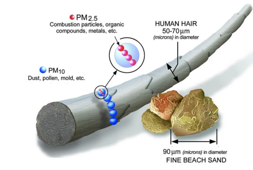
Particulate matter (PM) is a mixture of solid small particles in the air [61].
There are mainly two categories of PM pollutants, PM10 and PM2.5, which
includes particles with diameters smaller than 10 and 2.5 micrometers
respectively. In order to illustrate just how small these particles are, one can
imagine that a strand of hair measures 70 micrometers, making PM2.5 thirty
times finer, see Figure 2. PM is the result of a variety of chemicals including
nitrates, sulfates, dust, pollen among others being emitted in the air by
vehicles, factories and fires only to name a few.
Figure 2: Example on how small the particle matter pollutants are in comparison to some
commonly recognized objects, here a strand of hair and beach sand (Source: US EPA [61]).
The potential negative effects these particles can have on humans and the
environment are many as mentioned by several governmental sources
[61][62]. Short-term exposure can lead to irritation in eyes and throat and an
15increased risk of heart attacks and irregular heart rhythm for people already
suffering from heart diseases. Being exposed for a longer period might lead to
reduced lung function and development of respiratory diseases, which in some
extreme cases lead to premature death.
Environmental effects include reduced visibility due to increased levels of
PM2.5 in the air, also called smog or haze [63], causing the sunlight to be
blocked and resulting in reduced visibility. Increased levels of PM also affect
nature’s balance by making water and soil more acidic, causing harm to both
the nature and the animals living there.
3.1.2 Ground level Ozone
At lower altitudes, ozone (O3) can be formed by reactions of emissions of
nitrogen oxides and volatile organic compounds (emitted gases from for
example household products like paint and aerosol sprays, VOCs) [64].
Ground-level ozone is also called bad ozone or a secondary pollutant due to
the fact it is created by the reaction of two primary pollutants [65]. This has a
negative effect on both the environment and human health as well as causing
corrosion of materials by cracking facades and fading colors of clothing. A
high concentration of ozone will have significant effects on forests and crops
which consequently will impact humans and animals. Breathing ozone has
similar effects as PM, particularly for individuals already suffering from
respiratory and lung diseases [66].
3.1.3 Nitrogen Dioxide
Nitrogen dioxide (NO2) is part of the group of nitrogen oxides (NOX) where it
is considered the most harmful of the group [67, p. 2]. It is created by burning
fossil fuel and originates from emissions by vehicles and other machinery.
This pollutant causes respiratory problems similar to PM and O3, having
impacts on the lungs and reducing the immunity against lung infections [68,
p. 2]. High levels of NO2 is particularly dangerous for people suffering from
asthma since it has shown to trigger more frequent and intense attacks.
Looking at the environmental point of view and its consequences, NO2 can
impact water and form acid rain which is harmful for forests and water
reservoirs like lakes [67]. It is also one of the main contributors to haze and
smog throughout cities.
3.1.4 Summary Air Pollutants
What all the pollutants described have in common is that they all are
problematic for people suffering from respiratory diseases and risks causing
more to fall into this category by exposing them to airborne toxins. Not only is
it a problem for humans and animals, but also the environment which
includes forests, lakes and crops. This is nothing new but remains a severe
problem which needs to be addressed in order to gain control over the levels
of pollution across the world.
16You can also read