Global Geodetic Observing System
←
→
Page content transcription
If your browser does not render page correctly, please read the page content below
IAG mid-term report – Travaux 2019-2021 – GGOS reports                1

                      Global Geodetic Observing System
                                      https://www.ggos.org

                             President: Basara Miyahara (Japan)
                          Vice President: Laura Sánchez (Germany)

As the observing system of the IAG, the Global Geodetic Observing System (GGOS) facilitates
a unique and essential combination of roles centering upon advocacy, integration, and
international relations. GGOS aims to provide the observations needed to monitor, map, and
understand changes in the Earth’s shape, rotation, and mass distribution, to provide the global
geodetic frame of reference for measuring and consistently interpreting key global change
processes and for many other scientific and societal applications, and to benefit science and
society by providing the foundation upon which advances in Earth and planetary system science
and applications are built. To complete its mission, GGOS develops and maintains working
relationships among a variety of internal and external groups and organizations.

GGOS Structure
The GGOS structure is illustrated in Figure 1. The decision-making entities are the Consortium,
the Coordinating Board and its Executive Committee. Permanent Standing Committees and
limited-term Working Groups are the thematic working bodies of GGOS and are distributed
over two Bureaus, the Science Panel and the Focus Areas, as well as affiliated organizations.
In addition to being the Secretariat of GGOS, the Coordinating Office coordinates the activities
of GGOS including communications, outreach, and external relations; as well as maintaining
and developing the GGOS website and social media presence.

Figure 1. Organization chart of GGOS.
2

Overview

The GGOS renewed its structure in 2019 including the election of new President and Vice
President and the restructuring of the GGOS Consortium and GGOS Coordinating Board. A
Working Group on "DOIs for Geodetic Data Sets" was newly established within the GGOS
Coordinating Office. The Working Group on "ITRS Standards for ISO TC 211" completed its
work and was dissolved with successful contribution to ISO 19161-1. The Working Group on
"Establishment of the Global Geodetic Reference Frame (GGRF)" was renewed and renamed
to Working Group on "Towards a consistent set of parameters for the definition of a new GRS"
and continues to work on the challenge to define a new GRS four more years. The GGOS Focus
Area "Sea Level Change" was terminated in 2019.

The GGOS Bureau of Products and Standards (BPS) published a 2nd updated version of the
BPS inventory in the Geodesist's Handbook 2020 to compile and refine an inventory on
standards and conventions used for the generation of IAG products.

The GGOS Focus Area “Unified Height System” defined a strategy for the implementation of
the International Height Reference System (IHRF) and is currently working in the first
computation of the IHRF. The Focus Area “Geohazards” played a central role in the
development of the initiative “GNSS enhancement to tsunami early warning systems
(GTEWS)” and presently is supporting the creation of the GTEWS Consortium within the
Community Activity “Geodesy for the Sendai Framework” of the Group on Earth Observations
(GEO). The Focus Area “Geodetic Space Weather Research” identified four central challenges
and established four dedicated working groups.

As a mechanism to increase participation in GGOS, the second of two GGOS Affiliates was
established in 2021. GGOS D-A-CH is a regional affiliate group of German-speaking countries
and its name is comprised of the country codes D (Germany), A (Austria) and CH
(Switzerland). GGOS D-A-CH has been created by strong collaboration between the national
geodetic commissions of these countries and developed based upon a strategic White Paper on
“Geodesy 2030”. Its founding chair is Hansjörg Kutterer of Karlsruhe Institute of Technology.
Moving forward, GGOS D-A-CH will formulate Terms of Reference with a clear focus on
strategic topics in GGOS-related science. As a GGOS Affiliate, the group will have a
representative to GGOS Consortium and GGOS Coordinating Board.

One of the main forces of GGOS during the period 2019-2021 is outreach and communication.
GGOS renewed its website (https://www.ggos.org) to enhance outreach and communication to
non-geodesists at the end of 2020. The new website focuses two faces of GGOS: one as an
organization to foster collaboration between stakeholders mainly in IAG, and another as the
geodetic observing system, which underpins science and society as fundamental infrastructure
for monitoring the Earth. The new website put IAG Services in the front page to make them
more visible and to provide easier access to their Internet portals. The new site also provides
"products" and "observation" pages, which describe the role and importance of Geodesy, its
observation techniques and products to non-geodesists with easy and brief explanations as well
as eye-catching visual aids. The new site provides articles on Geodesy, which are also helpful
for non-geodesists to understand what Geodesy is and why Geodesy is so important for science
and society. Another new fundamental tool is the repository of main documents in the GGOS
Cloud (https://cloud.ggos.org), which enables us to share the GGOS related materials such as
Terms of Reference, reports, papers and presentations and ensures their long-term availability.
IAG mid-term report – Travaux 2019-2021 – GGOS reports                  3

GGOS also further strengthened and expanded its external relations and stakeholder
engagement. Continued participation in GEO included establishment of a geodesy advocacy
Community Activity within GEO, titled “Geodesy for the Sendai Framework” as well as
ongoing and diverse participation in the GEO Programme Board. GGOS also continues to
strongly support the actions and initiatives of the UN GGIM Subcommittee on Geodesy, and
intends to expand this support to the new UN Global Geodetic Centre of Excellence scheduled
to commence operations in early 2022.

In addition to external advocacy, GGOS routinely looks inward to identify the best ways to cite
and track the impact of the geodetic data, products, and other resources that the IAG and its
services make freely and openly available to the general public. At the Unified Analysis
Workshop in 2019, Digital Object Identifiers (DOIs) were discussed as unique identifiers of
data as well as publications. DOIs are already widely used by publishers, and their
implementation for data sets is expected to be beneficial for both users as well as data providers.
Users can get easy access to data cited in journals, and use of DOIs improves traceability of
published results and discoverability of data sets. This eliminates confusion about data used and
enable wider distribution of data sets. Data providers can include information about data set on
landing page (metadata), and DOIs easily allow number of data publications to be tracked and
number of times data is used to be counted. Data providers can receive proper credit for their
published data. Considering these benefits, the GGOS established a new Working Group on
DOIs for Geodetic Data Sets in 2019. Its chair is Kirsten Elger of GFZ Potsdam and more than
20 members are participating in the WG, mainly from IAG Services. The WG has analyzed use
cases and best practices both in geodesy as well as in other scientific fields, and is currently
working on how to establish parameters and procedures for properly assigning DOIs to geodetic
data set.

Consortium

The GGOS Consortium functions as the large steering committee and collective voice of
GGOS, and is comprised of one representative from each GGOS Affiliate and up to two
representatives from each IAG Service, Commission, and Inter-Commission Committee.
According to the GGOS Terms of Reference, the Consortium membership is reviewed and
refreshed every four years, which last one took place coincident to the 2019 IUGG General
Assembly. The members of the GGOS Consortium during 2019–2023 are listed in Table 1.
The President of GGOS is also the chair of the GGOS Consortium. The GGOS Consortium
meets annually, which during 2019–2021 took place during the GGOS Days:
       1. GGOS Days 2019, Rio de Janeiro, Brazil, 12-14 November 2019
       2. GGOS Days 2020, held virtually via Video Conference, 5-7 October 2020

               Table 1. Members of the GGOS Consortium During 2019–2023
Organization                          Name               Title
GGOS                                  Basara Miyahara Chair
GGOS Affiliate: GGOS Japan            Yusuke Yokota      Designated GGOS Representative
GGOS Affiliate: GGOS D-A-CH           Markus Rothacher Designated GGOS Representative
                                                         (2021-2023)
                                 IAG Service Representatives
International Gravimetric Bureau      Sylvain Bonvalot Director
(BGI)                                 Sean Bruinsma      Designated GGOS Representative
International Centre for Global Earth E. Sinem Ince      Designated GGOS Representative
Models (ICGEM)
4

International DORIS Service (IDS)     Laurent Soudarin Director, Central Bureau
                                      Frank Lemoine      Chair, Governing Board
International Earth Rotation and      Daniela Thaller    Director, Central Bureau
Reference Systems Service (IERS) Robert                  Analysis Coordinator
                                      Heinkelmann
International Service for Geoid (ISG) Urs Marti          Designated GGOS Representative
                                      Jianliang Huang    Designated GGOS Representative
International Gravity Field Service Riccardo Barzaghi Chair
(IGFS)                                Georgios Vergos Director, Central Bureau
International GNSS Service (IGS)      Nicholas Brown     Designated GGOS Representative
                                      Arturo Villiger    Designated GGOS Representative
The International Laser Ranging       Toshimichi Otsubo Chair, Governing Board
Service (ILRS)                        Erricos Pavlis     Chair, Analysis Working Group
International VLBI Service for        Axel Nothnagel     Chair, Directing Board
Geodesy and Astrometry (IVS)          Dirk Behrend       Director, Coordinating Center
Permanent Service for Mean Seal       Elizabeth Bradshaw Director
Level (PSMSL)                         Andy Matthews      Designated GGOS Representative
International Geodynamics and Earth Christoph Foerste Designated GGOS Representative
Tides Service (IGETS)                 Hartmut Wziontek Designated GGOS Representative
International Digital Elevation Model Kevin M. Kelly     Director
Service (IDEMS)                       Christian Hirt     Designated GGOS Representative
                             IAG Commissions Representatives
Commission 1: Reference Frames        Christopher        President
                                      Kotsakis
                                      Tonie van Dam      Designated GGOS Representative
Commission 2: Gravity Field           Adrian Jäggi       President
                                      Mirko Reguzzoni Vice President
Commission 3: Earth Rotation and Janusz Bogusz           President
Geodynamics                           Chengli Huang      Vice President
Commission 4: Positioning and         Paweł Wielgosz     President
Applications                          Michael Schmidt Vice President
                IAG Inter Commission Committee (ICC) Representatives
ICC on Theory (ICCT)                  Pavel Novák        President
                                      Dimitrious Tsoulis Designated GGOS Representative
ICC on Climate Research (ICCC)        Anette Eicker      President
                                      Carmen Boening Vice President
ICC on Marine Research (ICCM)         Yuanxi YANG        President
                                      Heidrun Kopp       Designated GGOS Representative

Coordinating Board

The Coordinating Board is the decision-making body of GGOS. The members of the GGOS
Coordinating Board during 2019–2023 are listed in Table 2.

The President of GGOS is the Chair of the Coordinating Board. The Coordinating Board meets
twice-per-year, which during 2019–2021 took place during GGOS Days and around the EGU:
       1. GGOS Days 2019, Rio de Janeiro, Brazil, 12-14 November 2019
       2. GGOS CB Meeting, held virtually via Video Conference, 8 May 2020
       3. GGOS Days 2020, held virtually via Video Conference, 5-7 October 2020
       4. GGOS CB Meeting, held virtually via Video Conference, 7 May 2021
IAG mid-term report – Travaux 2019-2021 – GGOS reports             5

Table 2. Members of the GGOS Coordinating Board During 2019–2023
 Position                                     Voting Name
 Chair                                          Yes   Basara Miyahara
 Vice Chair                                     Yes   Laura Sánchez
 Chair, Science Panel                           Yes   Kosuke Heki
 Director, Coordinating Office                  Yes   Martin Sehnal
 Manager, External Relations                    Yes   Allison Craddock
 Director, Bureau of Networks &                 Yes   Mike Pearlman
 Observations
 Director, Bureau of Products & Standards       Yes   Detlef Angermann
 Representative, GGOS Affiliates                Yes   Toshimichi Otsubo
                                                Yes   Hansjörg Kutterer (2021-2023)
 Representative, IAG President                  Yes   Zuheir Altamimi
 Representative, IAG Services                   Yes   Riccardo Barzaghi
                                                Yes   Daniela Thaller
                                                Yes   Sean Bruinsma
                                                Yes   Robert Heinkelmann
 Representative, IAG Commissions and ICC        Yes   Tonie Van Dam
                                                Yes   Adrian Jäggi
 Member-at-Large                                Yes   Maria Cristina Pacino (2019-2021)
                                                      Claudia Tocho (2021-2023)
                                                Yes   Nicholas Brown
                                                Yes   Ludwig Combrinck
                               GGOS Focus Area (FA) Leads
 FA Unified Height System                       No    Laura Sánchez
 FA Geohazards                                  No    John LaBrecque
 FA Geodetic Space Weather Research             No    Michael Schmidt
                                  GGOS Committee Chairs
 Committee on Satellite and Space Missions      No    Roland Pail
 Committee on Data and Information              No    Martin Sehnal (2019)
 Systems                                              Nicholas Brown (2020-2023)
 Committee on Contribution to Earth System      No    Maik Thomas
 Modelling
 Committee on PLATO (IAG WG)                    No    Daniela Thaller
 Committee on Essential Geodetic Variables      No    Richard Gross
                               GGOS Working Group Chairs
 JWG: Ground Survey and Co-Location             No    Ryan Hippenstiel
 JWG: Definition of a new GRS                   No    Urs Marti
 WG: DOIs for Geodetic Data Sets                No    Kirsten Elger
                                           Others
 Manager, GGOS Web and Social Media             No    Martin Sehnal
 Immediate Past Chair of GGOS                   No    Richard Gross

Executive Committee

The Executive Committee of the GGOS Coordinating Board serves at the direction of the
Coordinating Board to accomplish the day-to-day activities of the tasks of GGOS. The members
and guest observers of the Executive Committee during 2019–2023 are listed in Table 3.

The President of GGOS is the Chair of the Executive Committee. The Executive Committee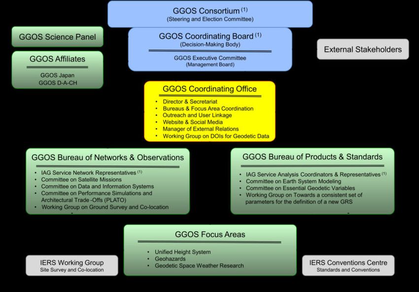
6

holds monthly conference calls and meets face-to-face or virtual during the meetings of the
Coordinating Board (see above).

          Table 3. Members of the GGOS Executive Committee During 2019–2023
 Position                                     Status Name
 Chair                                       Member Basara Miyahara
 Vice Chair                                  Member Laura Sánchez
 Director, Coordinating Office               Member Martin Sehnal
 Manager, External Relations                 Member Allison Craddock
 Director, Bureau of Networks & Observations Member Mike Pearlman
 Director, Bureau of Products & Standards    Member Detlef Angermann
 Representative, IAG Services                Member Riccardo Barzaghi
 Representative, IAG Commissions             Member Adrian Jäggi
 Immediate Past Chair of GGOS                  Guest Richard Gross
 Chair, Science Panel                          Guest Kosuke Heki
 Representative, IAG President                 Guest Zuheir Altamimi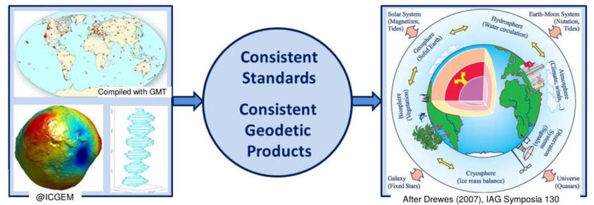
IAG mid-term report – Travaux 2019-2021 – GGOS reports             7

GGOS Coordinating Office

Director:                              Martin Sehnal (Austria)
Manager of External Relations:         Allison Craddock (USA)
Chair of WG on DOIs:                   Kirsten Elger (Germany)

Working Group (WG) affiliated with GGOS Coordinating Office:
   •   GGOS Working Group on “DOIs for Geodetic Data Sets”

Purpose and Scope

The GGOS Coordinating Office (CO) serves as a centralized administrative and organisational
entity and interacts with the GGOS Bureaus and Focus Areas for organisational matters. The
CO performs the day-to-day activities and generates reports in support of the various
components of GGOS especially the GGOS Executive Committee and the GGOS Coordinating
Board. The CO ensures information flow, maintains and archives documentation and in its long-
term coordination role ensures consistency and continuity in the contributions of the GGOS
components. The CO implements and operates the GGOS website and outreach.

The Manager of External Relations connects GGOS with external organisations.

The Director of the CO and the Manager of External Relations are both ex-officio members of
the GGOS Coordinating Board and GGOS Executive Committee.

Activities and Actions

New Director of GGOS Coordinating Office
The director of the GGOS Coordinating Office changed in September 2019. Helmut Titz (BEV,
Austria) stepped down due to health issues and Martin Sehnal (BEV, Austria) followed him
interimistically and was finally approved by the BEV (Federal Office of Metrology and
Surveying, Austria) as the new director of GGOS CO in July 2020.

Day-to-day activities and organisational matters
   •   Communicate with all entities of GGOS by sending and answering on emails
   •   Organizing GGOS Executive Committee Teleconferences
   •   Creating posters, brochures, logos, images and templates
   •   Collecting/Distributing reports
   •   Meeting preparation

New GGOS website – https://ggos.org

One major goal of GGOS is to communicate and advocate the benefits of Geodesy to scientists,
user communities, policy makers, funding organizations and society. To reach this goal, it is
essential to establish a strong online presence. The GGOS website serves as a source of
information about GGOS, geodetic data, products, and services, as well as other non-technical
resources for the IAG community.

After the transition of the GGOS CO from ASI (Agenzia Spaziale Italiana, Italy) to BKG
(Bundesamt für Kartographie und Geodäsie, Germany) in 2015, it was transitioned again to
8

BEV (Federal Office of Metrology and Surveying, Austria) in 2016. BEV installed a completely
new server system and launched a new designed GGOS website in 2017. In 2019 the GGOS
Executive Committee decided to refresh and further develop it again to optimize the usability.

The new GGOS website (see image), which was published in December 2020, now emphasizes
more on the “Observing System” than on the “GGOS organization” itself. Therefore, the
website was enhanced to provide an extensive information platform to bring the IAG
observations, products and services in the focus and to attract users from other disciplines.
Visually attractive graphics navigate users to easy understandable introductions about geodetic
products or observation techniques. Observation and product descriptions are complemented
with a huge selection of web links containing scientific descriptions and data repositories
provided by the IAG Services and additional data sources.

From 2019 to 2021, the GGOS Coordinating Office worked intensively together with all GGOS
components and other important persons of the geodetic scientific community, to establish and
launch this new information platform. Furthermore, the contributions of the IAG Services and
other providers of geodetic products are gratefully acknowledged. The new GGOS website
contributes to make geodesy more visible and to promote IAG and GGOS at global and
multidisciplinary levels.

New GGOS Cloud – https://cloud.ggos.org

A first version of the GGOS Cloud service was installed in September 2017 and was based on
the OwnCloud software. But due to several organizational and technical issues it was switched
IAG mid-term report – Travaux 2019-2021 – GGOS reports                   9

off. Together with the new GGOS Website, the GGOS Cloud was new developed and was
published again in 2020. It is now based on the worldwide often used, regularly updated and
free software Nextcloud. GGOS Cloud is fully integrated in the GGOS Website and is used as
a file hosting platform for public files. Additionally, it is used to share files within the GGOS
community.

GGOS Blog & GGOS Newsletter – https://blog.ggos.org

A blog was set up on the GGOS website, where users can find latest news and events of GGOS
as well as short introductions into Geodesy and GGOS. Interested persons can subscribe to the
GGOS mailing list to receive this news via the GGOS Newsletter https://ggos.org/newsletter/.

GGOS General Outreach Articles

In 2020 the idea was born to publish popular articles regularly (about 2-4 times a year) via email
mailing list and also within the GGOS website. The aim of these articles is to strengthen the
GGOS Outreach Activities by addressing readers with little or no knowledge of geodesy and
its techniques or products. Therefore, the target audience consists of non-geodesists,
geoscientists, geodesy students, politicians, etc. It is not the goal to offer updates to the geodetic
scientific community. The first articles are planned to publish in 2021 or 2022.

GGOS social media presence via Twitter

A GGOS Twitter account named @IAG_GGOS is operated by the GGOS CO to be present in
the social media and to speed up dissemination of GGOS-related information to the customers.

Organized Conferences & Meetings

    •   Unified Analysis Workshop (UAW) (2019) - together with IERS
    •   Virtual GGOS Coordinating Board (CB) meetings (2020, 2021)
    •   GGOS Days 2019, Rio de Janeiro, Brasilia
    •   GGOS Days 2020, virtual conference

Conference attendance

    •   European Geosciences Union (EGU) (2020, 2021)
    •   American Geophysical Union (AGU) (2019, 2020)
    •   IAG Scientific Assembly (2021)
10

GGOS External Relations

Manager of External Relations: Allison Craddock (USA)

The position of GGOS Manager of External Relations was officially approved at the Vienna
GGOS Days in October 2017. External Relations is based in the Coordinating Office, and
works to ensure that GGOS, the IAG, and geodesy in general is represented and visibly
contributing to stakeholder initiatives in service to science, Earth observation applications, and
society.

Stakeholder Organization Participation
                                                                               Working Groups on
       Group on Earth         GGOS represents the
                                                          Participating           Disaster Risk
                                                     Organization member       Reduction, Capacity
        Observations            IAG on the GEO
                                                     of the GEO Executive     Development, Climate
                              Programme Board,
           (GEO)                                          Committee             Change, and Open
                                                                                  Data Policies.

                                                                                                          Supporting new
       Geodesy4Sendai        IAG/GGOS leads (with    Alignment with UNDRR     Political Advocacy for
                                                                                                         engagement with
                               IUGG) the new GEO     + Sendai Framework;       Geodesy and Support
         (GEO Work              Geodesy4Sendai        contributions to UN     for Geodetic Capacity
                                                                                                           International
                                                                                                       Telecommunications
        Programme)            Community Activity        GAR 2019, 2022               Building
                                                                                                               Union

       Committee on
                                                      supporting the use of
            Earth             GGOS participates in
                               the CEOS Working
                                                      satellite geodesy for
                                                                              Engaging in Capacity
                                                                               Building initiatives
                                                        understanding
        Observation           Group on Disasters,
                                                            disasters
                                                                              relevant to geodesy
      Satellites (CEOS)

                                                       Alignment with UN
         UN GGIM             IAG and Member State      GGIM-World Bank          Outreach to GGIM       Support for the Global
       Subcommittee               Delegation         Integrated Geospatial    Regional Groups and       Geodetic Centre of
                                representation            Information         GGIM WG on Disasters      Excellence (GGCE)
        on Geodesy                                     Framework (IGIF)

      ITU Focus Group
                              Novel decentralized    Developing policy and
        AI for Natural        processing of GNSS       protocols to work
                                                                              Inclusive to countries
                                                                              with limited internet
                                data; Federated           with export
           Disaster            machine learning           restrictions
                                                                                   bandwidth
        Management

Figure: GGOS external relations with stakeholder organizations, as of December 2020.

Group on Earth Observations (GEO)

Participation at the Programme Board level ensures that
IAG/GGOS efforts in alignment with GEO’s global
priorities (supporting the UN SDGs, Sendai Framework,
as well as the Paris Agreement on Climate Change) are well supported and complimentary to
other related work – as well as preventing unnecessary redundancy of work. Geodetic
observations have a clear role in helping to reduce the risk of disasters, as well as contribute to
disaster preparedness with better mitigation and response. Earth observations also play a major
role in monitoring progress toward, and achieving, the SDGs.
GGOS has represented the IAG in the Group on Earth Observations (GEO) Programme Board
since 2018, and was selected to serve on the GEO Executive Committee in 2021. GGOS
Executive Committee members Richard Gross and Allison Craddock have served as IAG
representatives to the GEO Programme Board since 2018. Within the Programme Board, IAG
has been represented and contributed to the following Subgroups:
IAG mid-term report – Travaux 2019-2021 – GGOS reports 11
• Subgroup on Sustainable Earth Observations: which works in tandem with the
GEOSS In-Situ Earth Observation Resources foundational task to assess the current
Foundational Tasks focusing on both GEOSS Satellite and In-Situ Earth Observation
Resources, and to evaluate strengths and weaknesses of observing systems for GEO’s
activities over the past decade, and to clarify the challenges in coordination of in-situ
observations as well as in integrating in-situ and satellite observations toward
coordinated observation systems in the future to implement GEOSS.
• Subgroup on the Sendai Framework: This subgroup supports GEO’s strategic
engagement priority area on the Sendai Framework for Disaster Risk Reduction, in the
realm of championing and supporting the development of policy objectives that add
value, drive efficiencies, and promote the uptake of Earth observations in alignment
with Sendai and other disaster risk reduction initiatives. This is particularly relevant to
supporting the GGOS Geohazards Focus Area and its Global Navigation Satellite
System to Enhance Tsunami Early Warning Systems (GTEWS).
• Subgroup on Equality, Diversity, and Inclusion: This subgroup supports the strategic
aim of developing GEO as an institution that provides a fair, supportive and encouraging
networking environment with which a diverse set of participants engage responsibly.
This subgroup aims to ensure that equality, diversity and inclusivity are fully
considered, addressed, and embedded within GEO activities and decisions.
Additional IAG representation and participation at the Programme Board level included
supporting Work Programme Engagement Teams on Climate Change, Cross-Cutting
Applications, Sustainable Development Goals, and Disaster Risk Reduction/Hazards.
GGOS also represents IAG in leadership and participation in GEO Working Groups, which
were established in 2020 and are open to participation from all GEO stakeholders. GGOS
currently participates on behalf of IAG in the Working Groups on Disaster Risk Reduction,
Capacity Development (co-chair), Climate Change, and Open Data Policies.
Group on Earth Observations Community Activity: Geodesy for the Sendai Framework
In late 2019 at the GEO Canberra Ministerial Summit, the
IAG/GGOS proposal to form a GEO Community Activity
dedicated to supporting applications of geodesy to disaster
risk reduction was officially approved as a component of
the GEO Work Programme 2020-2022. The activity, titled
“Geodesy for the Sendai Framework” and often shortened
to “Geodesy4Sendai”, supports technical and scientific
work of the GGOS Geohazards Focus Area with political advocacy for geodesy, and support
for geodetic capacity building as a part of broader Earth observations for disaster risk reduction.
Geodesy4Sendai is jointly led by IUGG and IAG/GGOS, represented by John LaBrecque and
John Rundle. The GGOS Manager of External Relations, Allison Craddock, serves as its
executive secretary. To date, the work of Geodesy4Sendai has focused on the following
objectives:
• Supporting geodetic development and capacity building for disaster risk reduction and
resilience
• Identifies existing resources and stakeholder communities, and makes connections
• Identifies geodetic elements of targets and indicators of the Sendai Framework for
Disaster Risk Reduction
• Provides opportunity for other GEO efforts to interact with geodesy community12
• Integration with UN Sustainable Development Goals and UN-GGIM World Bank
Integrated Geospatial Information Framework
Geodesy4Sendai strongly aligns with and contributes to implementation of the Sendai
Framework for Disaster Risk Reduction, Targets F (Substantially enhance international
cooperation to developing countries through adequate and sustainable support to complement
their national actions for implementation of this framework by 2030) and G (Substantially
increase the availability of and access to multi-hazard early warning systems and disaster risk
information and assessments to the people by 2030), growing international cooperation and
resilience – especially in small island developing states – by supporting access to early warning
systems and other DRR information.
Committee on Earth Observation Satellites (CEOS)
GGOS has participated in CEOS Plenaries, discussing what
GGOS might need from participation in CEOS as an
Agency/Partner Update. This is an opportunity for GGOS
to speak about its plans and strategies in relation to CEOS,
as well as the benefits and expectations of CEOS from the GGOS perspective.
GGOS has recently supported the contributions of geodesy to disaster risk reduction by taking
an active role in the CEOS Working Group on Disasters, and Working Group on Capacity
Development, especially where the work of these two groups overlaps with GEO and/or UN
GGIM.
UN GGIM Subcommittee on Geodesy
GGOS supports and, as needed, represents the IAG at the United Nations
Committee of Experts on Global Geospatial Information Management
(UN GGIM). IAG works closely with the International Federation of
Surveyors (FIG) as Observer participants of the Sub-Committee on
Geodesy (SCoG), to provide stability and long-term planning for the GGRF. As the work of
the Subcommittee transitions from ideological to implementation-based, especially in the realm
of member states making commitments for infrastructure or other contributions, IAG/GGOS
participation within both the member state Delegations as well as IAG observers will be
important to ensure best possible support of this initiative.
Numerous GGOS members were active in the UN GGIM SCoG on behalf of the IAG this past
year:
• Harald Schuh, IAG; SCoG Working Group on Governance
• Detlef Angermann, IAG; SCoG Working Group on Policy, Standards, and Conventions
• Mike Pearlman, IAG
GGOS members also participate on behalf of their member state (country) and in consultation
with GGOS External Relations, including:
• Richard Gross, USA; SCoG Working Group on Governance
• Allison Craddock, USA; SCoG Working Group on Communications and Outreach,
Working Group on Education, Training and Capacity Building
• Basara Miyahara, Japan; SCoG Working Group on Education, Training and Capacity
Building
• Gary Johnston, Australia; SCoG Co-chair (until end of 2019)IAG mid-term report – Travaux 2019-2021 – GGOS reports 13
• Nicholas Brown, Australia; SCoG Co-chair (2020-present)
In the near future, GGOS will expand its involvement in GGIM as a component of strong IAG
support for the proposed UN Global Geodetic Center of Excellence, scheduled to start
operations in Bonn, Germany in early 2022.
For more information, please visit the UN-GGIM website:
http://ggim.un.org/UN_GGIM_wg1.html.
International Telecommunications Union (ITU)
Focus Group on Artificial Intelligence for Natural Disaster Management (AI4NDM)
In early 2021, GGOS collaborated with GEO Geodesy4Sendai and IUGG
GeoRisk Commission to propose a geodesy use case for the newly
established ITU Focus Group “AI for Natural Disaster Management.” The
focus group, which is co-chaired by ITU, the World Meteorological
Organization (WMO) and the UN Environment Program (UNEP), examines
how Artificial intelligence (AI) and associated machine learning
technologies and techniques can enhance our understanding of natural disasters and support
disaster relief/early warning.
GGOS is a co-chair of a topic group
examining the possible use of artificial
intelligence and machine learning for
“enabling Natural Hazards Risk Information Sharing Using Derived Products of Export-
Restricted Real-Time GNSS Data for Detection of Ionospheric Total Electron Disturbances.”
This project seeks to explore the feasibility of using AI for novel decentralized domestic
processing of GNSS data in countries where:
• Exporting of real-time GNSS data either prohibited by law, or;
• Participation/data sharing is restricted by limited internet bandwidth capacity (such as
in small island developing states).
The project will establish guidelines for possible development and sharing of export-permitted
data-derived products through artificial intelligence, federated machine learning, or a
combination thereof. There is the potential for this to ultimately enable sharing of life-saving
geodetic real-time tsunami risk information within the parameters of data export restrictions
and/or constrained data transmission infrastructure.
External Relations Geodesy Advocacy Initiatives:
Connecting GGOS with the United Nations Sustainable Development Goals and Sendai
Framework for Disaster Risk Reduction
There is tremendous potential to increase the exposure
and impact of GGOS by identifying potential
contributions and connecting existing relevant work to
efforts in support of both UN SDGs and the Sendai
Framework. GGOS has the potential to facilitate
linkages to agencies and other providers of geodetic
data, make existing geodetic data discoverable and
easily accessible, and to work toward standardization.14 The first External Relations Project, proposed in October 2017, sought to support the wide reach of the GATEW initiative by identifying numerous clear alignments with United Nations Sustainable Development Goals (SDGs) and Sendai Framework for Disaster Risk Reduction. The Manager of External Relations has worked with John LaBrecque, Lead of the Geohazards Monitoring Focus Area, to brainstorm strategies for aligning our work in natural hazards with the United Nations SDGs and Sendai Framework. These two prominent initiatives can clearly benefit from the focus group's involvement, will make GGOS more visible to organizations such as GEO, CEOS, and the UN, and could potentially lead to greater participation in GATEW/GTEWS and other GGOS efforts. GATEW/GTEWS successfully submitted a chapter/paper for the 2019 UN Global Assessment Report on Disaster Risk Reduction (GAR19), which is a major UN report addressing disaster risk reduction that contributes to regional and global platforms for disaster risk reduction, as well as the high-level political forum on sustainable development. The complete GAR19, published in May of 2019, is available to download here: https://gar.unisdr.org/sites/default/files/reports/2019-05/full_gar_report.pdf Following the success of advocating for geodetic contributions to tsunami early warning systems in the 2019 GAR, GGOS worked closely with the International GNSS Service to develop a second successful contribution to a GAR report, scheduled for publication in 2022. This contribution highlights the current and emerging geodetic contributions to complex disaster (wildfire) risk systems modelling, and is in strong support of recent work done by the IAG Inter-Commission Committee on Geodesy for Climate Research (ICCC) by highlighting and advocating the use of geodetic observations for climate studies. It further builds upon work to reinforce the utility of geodetic observations for disaster risk reduction and resilience, as well as introducing public health and wellbeing benefits. The GAR22 paper, titled “Transdisciplinary application of Global Navigation Satellite System Radio Occultation (GNSS-RO) to characterize atmospheric hazards and model systemic risk,” will also identify discrete geodetic contributions to UN Sustainable Development Goals for air quality, specifically Sustainable Development Goal 11: (Make cities and human settlements inclusive, safe, resilient, and sustainable); Indicator 11.6.2 specifically seeks to measure the annual mean levels of fine particulate matter (such as PM 2.5 and PM 10) in cities. Future Connections As GGOS connections with the SDGs and Sendai Framework mature, more opportunities to support these initiatives will become available. GGOS External Relations will pursue the most relevant and impactful avenues to ensure that IAG/GGOS enables the greatest use of geodetic data in support of these United Nations initiatives and beyond.
IAG mid-term report – Travaux 2019-2021 – GGOS reports               15

GGOS Working Group on DOIs for Geodetic Data Sets

Chair: Kirsten Elger (Germany)

Members
Chair: Kirsten Elger (GFZ, Germany), Detlef Angermann (TU Munich, Germany), Yehuda
Bock (UCDC, US), Sylvain Bonvalot (GET, France), Markus Bradke (GFZ, Germany),
Elizabeth Bradshaw (NOC, UK), Carine Bruyninx (ROB, Belgium), Daniela Carrion
(Politecnico Milan, Italy), Glenda Coetzer (SARAO, South Africa), Pierre Fridez (CODE/
AIUB, Switzerland), Elmas Sinem Ince (GFZ, Germany), Philippe Lamothe (Geodetic Survey
Canada), Vicente Navarro (ESA), Carey Noll (CDDIS/NASA, US), Mirko Reguzzoni
(Politecnico Milan, Italy), Jim Riley (UNAVCO, US), Dan Roman (NGS, US), Laurent
Soudarin (CLS, France), Daniela Thaller (BKG, Germany), Yusuke Yokota (GGOS Japan)

Associated Members
Godfred Amponsah (NGS, US), Sandra Blevins (CDDIS/NASA, US), Roelf Botha (SARAO,
South Africa), Francine Coloma (NOAA CORS, US), Allison Craddock (JPL/NASA, US),
Michael Craymer (Canadian Geodetic Networks, Canada), Theresa Damiani (NOAA CORS,
US), Patrick Michael (CDDIS/NASA, US), Basara Miyahara (GGOS, Japan), Mike Pearlman
(Harvard Smithsonian – Center for Astrophysics, US), Nacho Romero (ESA), Christian
Schwatke (TU Munich, Germany), Martin Sehnal (GGOS, BEV, Austria), Lori Tyahla
(CDDIS/NASA, US)

Motivation and purpose
Data publications with digital object identifiers (DOI) are best practice for FAIR sharing data.
Originally developed with the purpose of providing permanent access to (static) datasets
described in scholarly literature, DOI today are more and more assigned to dynamic data.
These DOIs are providing a citable and traceable reference of various types of sources (data,
software, samples, equipment) and means of rewarding the originators and institutions. As a
result of international groups, like the Coalition on Publishing Data in the Earth, Space and
Environmental Sciences (COPDESS) and the Enabling FAIR Data project, data with assigned
DOIs are fully citable in scholarly literature and many journals require the data underlying a
publication to be available – even before accepting an article. Initial metrics for data citation
allows data providers to demonstrate the value of the data collected by institutes and
individual scientists.
This is especially relevant for geodesy, because geodesy researchers are often much more
involved in operational aspects and data provision than researchers in other fields might be.
Therefore, compared to other scientific disciplines, geodesy researchers appear to be
producing less “countable scientific” output. Consequently, geodesy data and equipment
require a structured and well-documented mechanism which will enable citability, scientific
recognition and reward that can be provided by assigning DOI to data and data products.
To address these challenges and to identify opportunities for improved coordination and
advocacy within the geodetic community, the International Association of Geodesy’s (IAG)
Global Geodetic Observing System (GGOS) has established a Working Group on “Digital
Object Identifiers (DOIs) for Geodetic Data Sets”. This Working Group is designated to
establish best practices and advocate for the consistent implementation of DOIs across all
IAG Services and in the greater geodetic community.

Objectives
The main objectives and activities of this working group are
16

    (1) to identify what the community needs from consistent usage of DOIs for data in terms
        of being able to discover data, permanently cite data, and acknowledge the data
        providers;
    (2) to develop recommendations for DOI minting strategies for different geodetic data
        types and granularity across IAG Services (static, dynamic, observational data, data
        products, combination products, networks);
    (3) to develop recommendations for a consistent method for data citation across all IAG
        Services, to support data providers, and to provide quantitative support detailing the
        use of geodetic datasets and other resources;
    (4) to develop recommendations for connecting metadata standards for data discovery
        (e.g. DataCite, ISO19115) with community metadata standards (GeodesyML, Station
        Logs)

Activities and Actions
  ● physical kickoff meeting during AGU2019, monthly to bi-monthly video conferences.
  ● collection of data products and already existing and planned DOI activities for IAG
     services and geodetic data centres (living document).
  ● Outside the box: exploration of DOI minting and citation practices from other
     communities in the Earth sciences for potential adoption for geodetic data sets: e.g.
     network DOIs, persistent identifier for instruments, DOI citation recommendations for
     data compilations and hierarchical data products.

Outcomes
  ● support for the development of a DOI Service for the International Service for the
     International Service for the Geoid (IGS) in collaboration with GFZ Data Services (start
     July 2020).
  ● development of a concept for assigning DOI to hierarchical products (use case: ICGEM/
     COST-G1), adoption for ITRF2020 products agreed by IERS CB (May 2021).
  ● DOIs for “fast living” products (rapid and ultra-rapid products) are supported only if the
     data are archived for the long term by the datacentre (e.g. AIUB and GFZ have assigned
     DOIs to their rapid and ultra-rapid IGS products, these DOIs are assigned on the
     product level and for individual datasets)

Ongoing discussions and future plans
Latest and future discussions explore geodetic metadata standards, like GeodesyML, and the
possibility to include existing persistent identifier (PID), like ORCID for researchers, ROR
for institutions, PID for instruments and other DOI-related discovery metadata in the geodetic
metadata (for stations and data). These activities are aligned with current activities by the IGS
infrastructure group to implement GeodesyML in GNSS station metadata. Early adopters are
UNAVCO and ROB within M3G2, a common initiative between EPOS3 and EUREF4. Our
activities will include discussions with the developers of GeodesyML, the recommendation of

1
  Monthly GRACE series: https://doi.org/10.5880/ICGEM.COST-G.001, Monthly GRACE-FO series:
https://doi.org/10.5880/ICGEM.COST-G.002)
2
  https://gnss-metadata.eu
3
  https://www.epos-eu.org/
4
  http://www.euref.eu/
IAG mid-term report – Travaux 2019-2021 – GGOS reports 17
controlled vocabularies describing geodetic datasets (to be used in metadata for stations and
data, ideally the same vocabularies to facilitate cross-references between stations, sensory,
data and networks). Moreover, we will explore the potential implementation of the new
RDA5-derived concept for using PIDs for instruments6 and include the harmonization of DOI-
related metadata from different data centres in our recommendations.
Publications and conference presentations
Blevins, S. M., Tyahla, L., Michael, B. P., Noll, C. E. (2020) IN046-06 - DOIs for geodetic data and derived
product collections at the NASA GSFC CDDIS. AGU 2020 Fall Meeting (Online 2020).
Bruyninx, C., Fabian, A., Legrand, J., & Miglio, A. (2020). GNSS Station Metadata Revisited in Re-sponse
to Evolving Needs. Copernicus GmbH. https://doi.org/10.5194/egusphere-egu2020-18634
Craddoc, A., Elger, K., Sehnal, M., Fridez, P. (2019) DOIs for Geodetic Datasets. Unified Analysis
Workshop, October 2-4, 2019, Paris, France.
Elger, K. (2020): G022-02 - What are the benefits for assigning DOI to Geodetic data? First ideas of the
GGOS DOI Working Group - Abstracts, AGU 2020 Fall Meeting (Online 2020).
Elger, K. and the GGOS DOI WG (2020) Report from the GGOS Working Group on DOI for geo-detic data.
Oral presentation during the GGOS Days 2020 (October 5-7, 2020, online)
Elger, K., Angermann, D., Bock, Y., Bonvalot, S., Botha, R., Bradke, M., Bradshaw, E., Bruyninx, C.,
Carrion, D., Coetzer, G., Elger, K., Fridez, P., Ince, E. S., Lamothe, P., Navarro, V., Noll, C., Reguzzoni, M.,
Riley, J., Roman, D., Soudarin, L., Thaller, D., Yokota, Y., Members, A., Amponsah, G., Blevins, S., Craddock,
A., Craymer, M., Michael, P., Miyahara, B., Pearlman, M., Romero, N., Schwatke, C., Sehnal, M., Tyahla, L.
(2021): News from the GGOS DOI Working Group - Abstracts, EGU General Assembly 2021 (Online 2021).
https://doi.org/10.5194/egusphere-egu21-15081
Elger, K., Coetzer, G., Botha, R., GGOS DOI Working (2020): Why do Geodetic Data need DOIs? First
ideas of the GGOS DOI Working Group - Abstracts, EGU General Assembly 2020 (Online 2020).
https://doi.org/10.5194/egusphere-egu2020-17861
Ince, E. S., Barthelmes, F., Reißland, S., Elger, K., Förste, C., Flechtner, F., Schuh, H. (2019): ICGEM – 15
years of successful collection and distribution of global gravitational models, associated services and future
plans. - Earth System Science Data, 11, 647-674. https://doi.org/10.5194/essd-11-647-2019
Miglio, A., Bruyninx, C., Fabian, A., Legrand, J., Pottiaux, E., Van Nieuwerburgh, I., & Moreels, D. (2020).
Towards FAIR GNSS data: challenges and open problems. Copernicus GmbH.
https://doi.org/10.5194/egusphere-egu2020-18398
Reguzzoni, M., Carrion, D., De Gaetani, C. I., Albertella, A., Rossi, L., Sona, G., Batsukh, K., Toro Herrera,
J. F., Elger, K., Barzaghi, R., Sansó, F. (2021): Open access to regional geoid models: the International Service
for the Geoid. - Earth System Science Data, 13, 4, 1653-1666. https://doi.org/10.5194/essd-13-1653-2021
Sehnal, M., Craddock, A. B., Elger, K. (2020): GGOS Coordinating Office – Recent Achievements and
Activities. - Abstracts, AGU 2020 Fall Meeting (Online 2020).
Sehnal, M., Craddock, A., Elger, K. (2020): GGOS Coordinating Office – Recent Achievements and
Activities - Abstracts, EGU General Assembly 2020 (Online 2020) https://doi.org/10.5194/egusphere-egu2020-
6540
Yokota Y, Ishikawa T, Miyahara B, Otsubo M (2020): Issues and progress of Open Science in geodesy,
JpGU-AGU meeting 2020, MGI36-11
Yokota Y, Miyahara B, Otsubo M, Murayama Y, Munekane H, Ishikawa T (2020): Activities of WG on
DOIs in GGOS and Data DOI WG in GGOS Japan, JpGU-AGU meeting 2020, SGD01-05
5
RDA = Research Data Alliance (https://www.rd-alliance.org/)
6
Persistent Identification of Instruments Working Group: https://www.rd-alliance.org/groups/persistent-
identification-instruments-wg18
GGOS Affiliate: GGOS Japan
Chair: Toshimichi Otsubo (Japan)
Secretary: Basara Miyahara (Japan)
This multi-institution entity was initially established as GGOS Working Group of Japan in
2013, later approved as GGOS Affiliate in 2017 and renamed as GGOS Japan in 2019. The
purpose was to strengthen collaboration among Japan’s geodetic stations and colleagues and
to foster Japanese space geodetic activities internationally.
In recent years, GGOS Japan has constantly hosted its own annual meetings for broad range
of space geodetic research and activities, and also organise smaller-size meetings on specific
topics such as data DOI minting (2019) and co-location local tie (2020). It was remarkable
that Japanese institutes were nicely collaborated to conduct local tie campaigns for the
ITRF2020 project. A new aspect of GGOS Japan is to co-organise existing domestic
meetings in the field of VLBI and SLR in 2020 where GGOS Japan core members are often
given an opportunity of invited talks, and GGOS Japan is updating the terms of reference in
2021 so that co-hosting or supporting related meetings can be accommodated as one of its
roles. It should be noted that in accordance with the renewal of GGOS website the webpages
of GGOS Japan were largely updated, utilizing the GGOS Cloud function.
GGOS Japan is a loose organization of public sectors and university members. It does not
have membership qualification, but its core members are selected. As of May 2021 they are:
Chair: Toshimichi Otsubo (Hitotsubashi University)
Secretary: Basara Miyahara (Geospatial Information Authority of Japan)
Outreach: Shinobu Kurihara (Geospatial Information Authority of Japan)
Data DOI WG Lead: Yusuke Yokota (University of Tokyo)
Technique Representatives:
VLBI: Yu Takagi (Geospatial Information Authority of Japan)
SLR: Shun-ichi Watanabe (Japan Coast Guard)
GNSS: Hiroshi Takiguchi (Japan Aerospace Exploration Agency)
DORIS: Yuichi Aoyama (National Institute of Polar Research)
Gravity: Koji Matsuo (Geospatial Information Authority of Japan)
These members have actively involved in session planning of annual JpGU meetings and
annual Geodetic Society of Japan meetings, where “GGOS” is always seen as (a part of) a
session name. Likewise we should make every effort to utilize the “GGOS” keyword for
budget hunting, aiming at future GGOS Core sites in Japan or Antarctica. Encouraging
geodetic technology development is also in our scope - in addition to high precision and high
operability, we are aware that we should significantly reduce costs per geodetic facility
envisaging a denser global geodetic network in the future.IAG mid-term report – Travaux 2019-2021 – GGOS reports 19
GGOS Science Panel
Chair: Kosuke Heki (Japan)
Members:
• M. Rothacher (Switzerland)
• G. Blewitt (USA)
• T. Gruber (Germany)
• J. Chen (USA)
• J. Ferrandiz (Spain)
• J. Wickert (Germany)
• P. Wielgosz (Poland)
• Y. Tanaka (Japan)
• M. Crespi (Italy)
• B. Heck (Germany)
• D. Melgar (USA)
• D. Chambers (USA)
• E. Forootan (UK/Germany)
Purpose and Scope
The GGOS Science Panel is a multi-disciplinary group of experts representing the geodetic and
relevant geophysical communities that provides scientific advice to GGOS in order to help
focus and prioritize its scientific goals. The Chair of the Science Panel is a member of the
Coordinating Board and a permanent guest at meetings of the Executive Committee. This close
working relationship between the Science Panel and the governance entities of GGOS ensures
that the scientific expertise and advice required by GGOS is readily available.
Activities and Actions
The Science Panel provides scientific support to GGOS. During the 2019-2021 period, this
support included participation in Consortium, Coordinating Board, and Executive Committee
meetings and conference calls.
The Science Panel has been actively promoting the goals of GGOS by helping to organize
GGOS sessions at major scientific conferences. During the 2019-2021 period, GGOS sessions
have been organized at:
• 2019 American Geophysical Union Fall Meeting in San Francisco
• 2020 American Geophysical Union Fall Meeting (virtual conference)
• 2020 European Geosciences Union General Assembly (virtual conference)
• 2021 European Geosciences Union General Assembly (virtual conference)
• 2020 Japan Geophysical Union – American Geophysical Union Joint Meeting in Chiba,
Japan (virtual conference)
As a future session, the Science Panel proposed a GGOS session in the 2021 December
American Geophysical Union Fall Meeting (hybrid meeting in New Orleans). Owing to the
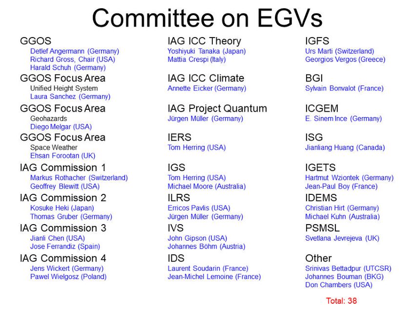
COVID19 pandemic, most international conferences in 2020 and 2021 were held as virtual on-20 line meetings. This situation is anticipated to continue until the condition recovers to the pre- 2019 status. In 2021, the Science Panel cooperated in the effort to renew the GGOS website, being led by the GGOS Coordinating Office and the GGOS Bureau of Products and Standards, specifically in reviewing the GGOS product page descriptions. Objectives and Planned Efforts for 2021-2023 and Beyond During the next two years the Science Panel will continue to participate in Consortium, Coordinating Board, and Executive Committee meetings and conference calls. In addition, the Science Panel will continue to help organize GGOS sessions at conferences and symposia including: • American Geophysical Union Fall Meetings • Asia Oceania Geosciences Society Annual Meetings • European Geosciences Union General Assemblies • International Association of Geodesy General and Scientific Assemblies The next Unified Analysis Workshop is planned to be held in Munich, Germany during 05-08 October 2021, but the workshop may be postponed considering the COVID19 situation in Europe and the world. The Science Panel will also continue to organize topical science workshops in order to determine the requirements that different scientific disciplines have for geodetic data and products. With the GGOS Bureau of Products and Standards, the Science Panel will help conduct a Gap Analysis to identify the gap between the data and products provided by the IAG and the needs of the user community. As part of this analysis, a list of Essential Geodetic Variables (EGVs) will be compiled along with observational requirements on those variables. This list of EGVs and their observational requirements can then be used to determine requirements on derived products like the terrestrial reference frame. Activities related to EGV will continue in the committee on EGV established in 2019, which includes the whole Science Panel members.
IAG mid-term report – Travaux 2019-2021 – GGOS reports               21

GGOS Bureau of Networks and Observations
Prepared by Michael Pearlman, Erricos C. Pavlis, Frank Lemoine, Daniela Thaller, Benjamin
Männel, Roland Pail, C.K. Shum, Nick Brown, Ryan Hippenstiel
Membership

Standing Committees affiliated with this Bureau:
   •   GGOS Standing Committee on Satellite Missions
   •   GGOS Standing Committee on Data and Information Systems
   •   GGOS Standing Committee on Performance Simulations and Architectural Trade-Offs
       (PLATO)
   •   IERS Working Group on Survey and Co-location
Associated Members and Representatives:
   •   Director (Mike Pearlman/CfA USA)
   •   Secretary (Claudia Carabajal/SSAI NASA USA)
   •   Analysis Specialist (Erricos Pavlis/UMBC USA)
   •   IERS Representative (Ryan Hippenstiel/ NOAA USA)
   •   Representatives from each of the member Services:
       o IGS (Allison Craddock/JPL CalTech USA, Michael Moore/GA Australia)
       o ILRS (Toshi Otsubo/Hitotsubashi U. Japan, Jean-Marie Torre/ OCA France)
       o IDS (Jérôme Saunier/IGN France, Pascale Ferrage/CNES France)
       o IVS (Hayo Hase/BKG Germany, Dirk Behrend/NASA USA)
       o IGFS (Riccardo Barzaghi/PM Italy, George Vergos/UT Greece)
       o PSMSL (Elizabeth Bradshaw/BODC UK, Lesley Rickards/ BODC UK)
   •   Representatives from each of the member Standing Committees:
       o PLATO (Daniela Thaller/BKG Germany, Benjamin Maennel/GFZ Germany)
       o Data and Information Systems (Nick Brown/GA Australia)
       o Satellite Missions (Roland Pail/TUM Germany, C.K. Shum/OSU USA)
       o IERS WG on Survey Ties and Co-location (Ryan Hippenstiel/ NOAA USA)
Purpose and Scope
  • Advocate for new and increased network participation, encouraging formation of new
     partnerships to develop new sites;
   •   Hold annual meetings of the Services and Standing Committees/Working Groups to
       share and discuss status plans, progress;
   •   Give talks and posters at public meetings to help familiarize the community with GGOS
       activities;
   •   Encourage integration of ground observation networks within the GGOS affiliated
       Network;
   •   Work with the UN GGIM and its affiliates to develop a plan for the implementation of
       the IAG geodetic network to satisfy the IAG requirement for the ITRF
Activities
   •   Participated and gave talks/posters on the BN&O and the ILRS at the AGU, EGU, IAG, JpGU-
       AGU, etc.
   •   The BN&O has been advocating for enhanced network infrastructure for Latin America,
       and participated and gave talks on the GGOS Bureau of Networks and Observations at;
22
o IUGG meeting “Implementation of the Global Reference Frame (GGRF) in
Latin America” in in Buenos Aires, September 16 - 20, 2019;
o SIRGAS meeting in Rio de Janeiro, November 12 – 14, 2019;
o Unified Analysis Workshop in Paris, October 2 – 4, 2019;
• Met with representative from existing and planned stations in Latin America to discuss
strategies, station details, equipment, etc.
• Supported new and vulnerable stations and analysis centers with letters of support and
documentation;
• New SLR and VGOS stations have recently become active and others are scheduled to
become active over the next few years; we have been disappointed by the schedule
delays in many stations so we are now taking a closer look at deployment schedules to
try to figure out what is realistic and what kind performance we can reasonably expect;
from that we can estimate the expected quality of our data products including the
Reference Frame.
• Worked with the IGFS define the gravity field measurement configuration at GGOS
network core and co-location sites; encourage the cooperation of the IGS and DORIS
with PSMSL to enhance the geodetic link of the tide gauges to the reference frame;
• A Memorandum of Cooperation had been established with ROSCOSMOS and the ILRS to
enhance cooperation and data diagnosis issues: this may provide a vehicle for broader
cooperation; the Russians have been regular participants in ILRS activities, we believe that are
desirous of formally joining the GGOS network;
• The GGOS “Site Requirements for GGOS Core Sites” document (with the IAG
Services) should be updated to include the requirements for the gravity field with the
guidance of the IGFS;
Outcomes and Future Plans
• Continue the tasks above
• Bureau Call for Participation in the “Global Geodetic Core Network: Foundation for
Monitoring the Earth System”; work with new potential groups interested in
participating; discussions are underway with the Russian SLR network; they participate
in ILRS and VLBI activities, but have yet to join the GGOS network; close with the
Russians;
• Project network status 5 and 10 years ahead to anticipate data product quality especially
the ITRF;
• Work with the IAG and the UN GGIM to develop a plan for the IAG Network to
satisfy the ITRF requirements;
• The Standing Committees/Working Groups will each continue their tasks (see below)
Websites:
https://ggos.org/about/org/bureau/bno/
Presentations and Posters
Pearlman, et al., Update on the Activities of the GGOS Bureau of Networks and Observation,
AGU Fall virtual meeting, December 14, 2018.
..
M. Pearlman, D. Behrend, A. Craddock, C. Noll, E. Pavlis, J. Saunier, A. Matthews, R.
Barzaghi,
D. Thaller, B. Maennel, S. Bergstrand, J. Müller, “GGOS: Current Activities and Plans of theYou can also read