ABC194 Urban Design, Landscape and Visual Effects Assessment Prepared for Pudong Housing Development Ltd & Foodstuffs (NZ) Ltd - FINAL - EPA NZ
←
→
Page content transcription
If your browser does not render page correctly, please read the page content below

ABC194
            Urban Design, Landscape and Visual Effects Assessment
Prepared for Pudong Housing Development Ltd & Foodstuffs (NZ) Ltd
                                                             FINAL
                                                     30 April 2021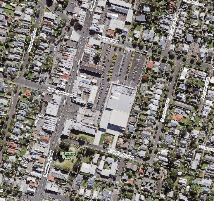
Document Quality Assurance
 Bibliographic reference for citation:
 Boffa Miskell Limited 2021. ABC194: Urban Design, Landscape and Visual Effects
 Assessment. Report prepared by Boffa Miskell Limited for Pudong Housing Development
 Ltd & Foodstuffs (NZ) Ltd.

 Prepared by:                        Rachel de Lambert
                                     Partner
                                     Landscape Architect
                                     Boffa Miskell Limited

 Reviewed by:                        Ben Clark
                                     Associate Principal
                                     Urban Designer
                                     Boffa Miskell Limited

 Status: FINAL                       Revision / version: 6                              Issue date: 30 April 2021

 Use and Reliance
 This report has been prepared by Boffa Miskell Limited on the specific instructions of our Client. It is solely for our Client’s use for
 the purpose for which it is intended in accordance with the agreed scope of work. Boffa Miskell does not accept any liability or
 responsibility in relation to the use of this report contrary to the above, or to any person other than the Client. Any use or reliance
 by a third party is at that party's own risk. Where information has been supplied by the Client or obtained from other external
 sources, it has been assumed that it is accurate, without independent verification, unless otherwise indicated. No liability or
 responsibility is accepted by Boffa Miskell Limited for any errors or omissions to the extent that they arise from inaccurate
 information provided by the Client or any external source.

Template revision: 20190517 0000

File ref: Document2

Template ref: Urban Design Assessment.dotx

Cover photograph: render © Warren and Mahoney 2021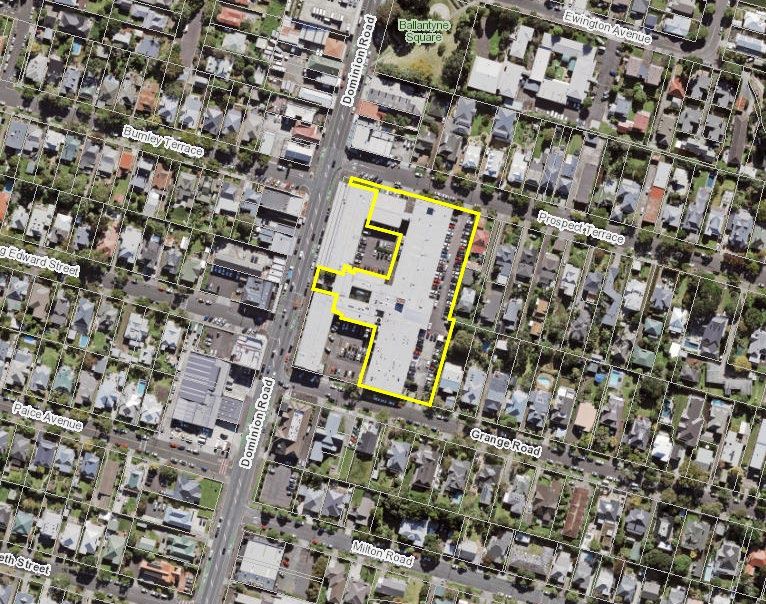
CONTENTS

1.0     Introduction                                                                                  1

2.0     Methodology                                                                                   2

        2.1     Urban Design                                                                          2
        2.2     Landscape and Visual Assessment                                                       2

3.0     The Site and its Urban Context                                                                4

4.0     The Proposal                                                                                  7

5.0     Statutory Context                                                                            10

6.0     Visual Catchment and Viewing Audiences                                                       12

        6.1     Visual Simulations                                                                   13

7.0     Assessment of Urban Design, Landscape and Visual Effects                                     13

        7.1     Urban Design Assessment                                                              13
        Context                                                                                      13
        Interfaces / Relationship to Neighbours                                                      14
        Signage                                                                                      16
        Building Scale and Mass                                                                      17
        Shading                                                                                      19
        Typologies and Activities                                                                    21
        Density / Intensity                                                                          21
        Pedestrian Access and Circulation                                                            22
        Natural Environment                                                                          24
        Landscape Treatment                                                                          24
        Crime Prevention Through Environmental Design (CPTED)                                        25
        7.2     Landscape and Visual Effects                                                         25
        Potential for effects                                                                        25
        Landscape effects                                                                            26
        Visual effects                                                                               29

8.0     Conclusion                                                                                   31

Boffa Miskell Ltd | ABC194 | Urban Design, Landscape and Visual Effects Assessment | 30 April 2021        i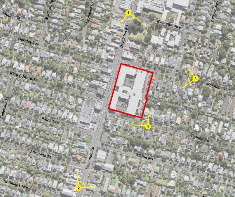
Appendices
     Appendix 1: Scale of Effects Ratings

     Figures
     Figure 1 Aerial photograph of site (Lot 2 Highlighted) ....................................5

     Figure 2 Eden Quarter development .............................................................. 7

     Figure 3 Site topography in relation to E6 Maungawhau / Mount Eden
                Volcanic Viewshaft ......................................................................10

     Figure 4 Special Character Areas Overlay – Business: Eden Valley ...........11

     Figure 5 Eden View Apartments – Source: render from sales website ........14

     Figure 6 Building bulk and mass relationship with eastern boundaries ........15

     Figure 7 Northeast view 13m height plane ...................................................18

     Figure 8 Prospect Terrace elevation showing steps in massing of
                proposed building ........................................................................18

     Figure 9 Grange Road elevation showing steps in massing of
               proposed building ........................................................................19

     Figure 10 Southwest view 13m height plane ................................................20

     Figure 11 Pedestrian lane .............................................................................23

     Figure 12 Pedestrian access ........................................................................23

     Figure 13 Axial view from south of Elizabeth Street facing north along
                Dominion Road including sky tower ............................................27

     Figure 14 Height Variation Control – Eden Valley AUP (OP) .......................28

     Figure 15 Location plan for visual simulations ..............................................29

ii   Boffa Miskell Ltd | ABC194 | Urban Design, Landscape and Visual Effects Assessment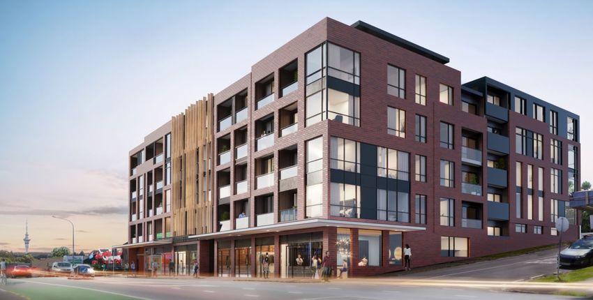
1.0 Introduction

Boffa Miskell has been requested to prepare an urban design and landscape and visual effects
assessment as part of the documentation for Resource Consent by Pudong Housing
Development Ltd & Foodstuffs (NZ) Ltd. The proposed development is significant, being a
comprehensively designed mixed use development on a large site fronting Dominion Road,
extending the full block between Grange Road and Prospect Terrace in Mt Eden.
The site is located within the Business - Mixed Use zone (B-MU) of the Auckland Unitary Plan
Operative in Part (AUP OP). It falls to be assessed as a discretionary activity overall due to the
provisions in respect of building demolition in a special character overlay (Rule D18.4.2).
Particular regard has been given to the frontages to Dominion Road, both residential streets
and neighbours including the overall strategy around building bulk and mass. Standards and
rules affecting the assessment of the proposed development with respect to urban amenity and
visual effects are the building height (Standard H13.6.1), new buildings in the special character
areas overlay (Rule D18.4.2) and the relevant assessment criteria for any new buildings.
Boffa Miskell landscape architects and urban designers have collaborated with the project
design team including lead architects Warren & Mahoney and heritage architects Plan Heritage.
Boffa Miskell landscape architects have also prepared the Landscape Concept Plan package to
accompany the application for resource consent. The assessment considers the proposed
development in the context of the existing as well as future built environment and the wider
context of Maungawhau / Mt Eden and Dominion Road.
The Lots which comprise the overall site have a complex pattern of ownership and easements,
in simple terms the ground floor retail fronting Dominion Road is in separate, multiple,
ownership with the remaining area including the first floor commercial space above the ground
floor tenancies forming the ‘site’ Lot 2 (0.81ha), via easements, has a range of development
rights over the existing retail shops on Lot 1. The proposal therefore works around the retail
shops and includes retention of the existing commercial space at first floor level fronting
Dominion Road and the redevelopment of the remainder of the site incorporating a 2,787.3m2
Foodstuffs supermarket (including retail, mezzanine, loading bay, click and collect and back-of-
house), retail, commercial and co-working floorspace, 122 residential units with common
amenity, parking, loading, access and circulation areas.
This assessment of urban design, landscape and visual effects is set out under the following
headings:
    1. Methodology
    2. The Site and its Urban Context
    3. The Proposal
    4. Statutory Context
    5. Assessment of Urban Design, Landscape and Visual Effects
    6. Conclusion

                                    Boffa Miskell Ltd | ABC194 | Urban Design, Landscape and Visual Effects Assessment   1
2.0 Methodology

    2.1           Urban Design
    There are a number of considerations relevant to the urban redevelopment of established sites
    in the B-MU, from strategic city-wide considerations to those specific to the site and its context.
    These considerations form a framework that has shaped the design process and against which
    the outcomes of the proposed development have been evaluated. This framework seeks to take
    into account the benefits, limitations and compromises that development proposals are
    designed to address, reflecting the nature of the proposal, the site and the context it sits within
    both physically and as framed by AUP (OP) objectives, policies and rules.
    The AUP (OP) sets a clear direction when assessing development proposals in that regard
    should be given to the planned future environment, that is what is anticipated as well as what
    presently exists.
    Key considerations relevant to urban design outcomes include:
           1. The opportunities and constraints of the site and its immediate context;
           2. The AUP(OP) policy framework, including bulk and location as well as outlook and
              building performance requirements for the B-MU
           3. The Auckland Design Manual guidance for apartments and mixed-use development;
              and
           4. General best practice urban design outcomes.
    Section 7 below provides an analysis of the urban design merits of the proposed development.

    2.2           Landscape and Visual Assessment

                  2.2.1       Methodology – Guidance
    Landscape and visual effects assessment in respect of the proposal has been undertaken with
    reference to a number of nationally and internationally recognised guidance documents. These
    include the Quality Planning Landscape Guidance Note 1 with its signposts to examples of best
    practice (including: the UK guidelines for landscape and visual impact assessment 2). This
    assessment has also been undertaken in consideration of the Auckland Council Information
    Requirements for the assessment of Landscape and Visual Effects (September 2017).

                  2.2.2       Methodology – Effects Rating
    This assessment of landscape and visual effects adopts ratings as to the level of effects, based
    upon the professional judgement of the author(s). The ratings are based on a seven-point scale

    1
        http://www.qualityplanning.org.nz/index.php/planning-tools/land/landscape/landscape-assessment
    2
        Guidelines for Landscape and Visual Impact Assessment, 3rd Edition, 2013

2   Boffa Miskell Ltd | ABC194 | Urban Design, Landscape and Visual Effects Assessment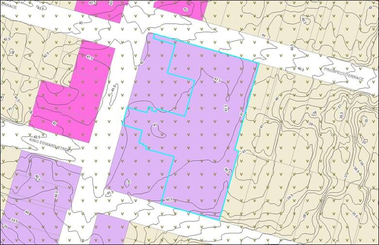
which includes very low; low; moderate-low; moderate; moderate-high; high; and very high
ratings, refer Appendix 1 for a full description of the levels.
Effects addressed in this assessment include:
    1. Landscape character and amenity effects derived from changes in the physical
       landscape, which may give rise to changes in its character and how this is experienced.
       This may in turn affect the perceived value ascribed to the landscape.
    2. Visual effects relating to the changes that arise in the composition of available views as
       a result of changes to the landscape, to people’s responses to the changes, and to the
       overall effects with respect to visual amenity.
Landscape and visual effects result from natural or induced change in the components,
character or quality of a landscape. Usually these are the result of landform or vegetation
modification or the introduction of new structures, activities or facilities into the landscape.
The nature of landscape and visual effects generated by any particular project can therefore be:
    1. positive (beneficial), contributing to the visual character and quality of the environment;
    2. negative (adverse), detracting from existing character and quality of environment; or
    3. neutral (benign), with essentially no effect on existing character or quality of
       environment.
The degree to which landscape and visual effects are generated by a proposal depends on a
number of factors, these include:
    i)    The degree to which the proposal contrasts, or is consistent, with the qualities of the
          surrounding landscape.
    ii)   The proportion of the proposal that is visible, determined by the observer’s position
          relative to the objects viewed.
    iii) The distance and foreground context within which the proposal is viewed.
    iv) The area or extent of visual catchment from which the proposal is visible.
    v) The number of viewers, their location and situation (static or moving) in relation to the
       view.
    vi) The backdrop and context within which the proposal is viewed.
    vii) The predictable and likely known future character of the locality.
    viii) The quality of the resultant landscape, its aesthetic values and contribution to the wider
          landscape character to the area.
To determine the level of effects, both the sensitivity of the landscape / viewing audiences and
the magnitude of change resulting from the proposed development, relative to what might be
expected to occur, are considered. The sensitivity of viewing audiences to visual change varies,
residents and people engaged in recreational activity reliant on its setting are generally
considered to be more sensitive to change, while people travelling through and working within a
locality are generally less sensitive. The extent of visual change is not however the measure of
any resulting effect(s), these are assessed in terms of the effect of change on the values of the
landscape, its key / valued characteristics and qualities.
Change in a landscape does not, of itself, constitute an adverse landscape or visual effect.
Landscape is dynamic and is constantly changing over time in both subtle and more dramatic

                                      Boffa Miskell Ltd | ABC194 | Urban Design, Landscape and Visual Effects Assessment   3
transformational ways. In urban landscapes where intensification is intended more intensive,
    taller and dense forms of urban development can be anticipated as part of the future
    environment. What is important is the management of landscape change so that significant
    adverse effects are avoided or sufficiently mitigated to ameliorate the effects of the change in
    land use.

                 2.2.3        Methodology – Approach
    Prior to conducting the assessment, a desktop study was completed which included a review of
    the relevant information relating to the Urban Design, landscape and visual aspects of the
    proposal. This information included:
         1. Auckland Unitary Plan (Operative in Part);
         2. Drawings of the proposed development, prepared by Warren & Mahoney, including
            context analysis, proposed layout, floorplans, sections, elevations and 3-dimensional
            modelling; and
         3. Aerial photography and Google Earth.
    Following the desktop study, in order to understand the receiving environment a specific site
    visit was undertaken on 02 October 2020 following earlier initial site visits to identify the site and
    its context. The author has, therefore, visited the Site and its surrounding area to understand
    the nature of existing development on the site and its physical and visual relationship to the
    surrounding streets and residential properties, as well as the context, character and visual
    catchment and viewing audiences from the wider area. The nature of higher density urban re-
    development occurring along the Dominion Road transport corridor under the direction of the
    Auckland Plan and AUP(OP) was also observed.
    Private viewing audiences identified in this assessment have been visually surveyed from
    publicly accessible locations during the site visit(s) with reference also made to aerial / 3D
    imagery.

    3.0 The Site and its Urban Context

    The wide, rectangular site is located on the eastern side of Dominion Road with a long broadly
    north / south frontage between Prospect Terrace in the north and Grange Road in the south.
    The site’s eastern boundary adjoins three residential lots being numbers 86 and 86A Prospect
    Terrace and 111 Grange Road. Typically, along Prospect Terrace there is a pattern where the
    originally deep lots have been cross-leased / subdivided to accommodate a rear lot. To the
    immediate south, across Grange Road, the shallow lot fronting Dominion Road comprises a
    funeral home, Davis Funeral Services, with the Auckland Guide Centre (located at 132 Grange
    Road) and then two residential lots, numbers 130 and 128 directly opposite the site. Across
    Prospect Terrace to the north the site adjoins the side elevation of the corner retail building,
    identified as ‘character defining’ in the AUP (OP), which is occupied by Liquorland Mt Eden with
    its service yard and small carpark accessed from Prospect Terrace, 93 Prospect Terrace is a
    standalone dwelling with 95 located behind, on a rear lot, to the east of which lie a series of

4   Boffa Miskell Ltd | ABC194 | Urban Design, Landscape and Visual Effects Assessment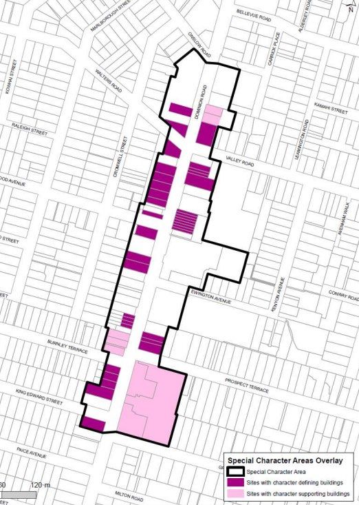
properties, including four street facing villas and two rear buildings comprising the ‘Claire
House’ Rest Home, part of this development lies directly opposite the site.
Along Dominion Road the block to the north, between Prospect Terrace and Ewington Ave,
comprises one and two storey, typical Dominion Road retail units, some of heritage character
and one, at the northern end, of more recent character, this unit adjoins Ballantyne Square a
neighbourhood pocket park defining the corner of Dominion Road and Ewington Ave.
The western side of Dominion Road in the locality of the site is of mixed character including
residential buildings converted to commercial uses, more recent development, including a ‘GAS’
service station opposite the Davis funeral home on the southern corner of Grange Road and
opposite the site a mix of one and two storey more recent and heritage buildings. Two streets
have their intersections onto Dominion Road opposite the site, Burnley Terrace in the north and
King Edward to the south. These intersections are offset from Prospect Terrace and Grange
Road, refer aerial photograph Figure 1 below.

Figure 1 Aerial photograph of site (Lot 2 Highlighted)

Dominion Road is historically and remains a key arterial connecting the central city to the
southern suburbs of Eden Terrace, Mt Eden and Mt Roskill through to the edge of the Manukau
Harbour (Dominion Road Extension) at Waikowhai Park. The general topography as
experienced from the road is gently undulating, with the landform rising to the east along side
streets toward Maungawhau (Mt Eden), in the northern section, and Te Tātua-a-Riukiuta (Three
Kings) in the southern section. The site itself lies in a dip in the landform between View Road

                                             Boffa Miskell Ltd | ABC194 | Urban Design, Landscape and Visual Effects Assessment   5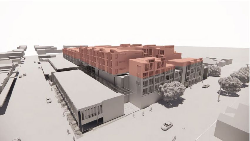
and Elizabeth Street which are approximately 18.5m and 5.5m higher than the road corridor
    adjacent to the site respectively.
    The former Dominion Road tram route carved the approximately 7.3km straight corridor from the
    central city, it remains a strategic transport corridor with a frequent public transport, bus,
    function. There is a southern bus stop adjacent to the site on Dominion Road with the northern
    stop located just north of the Prospect Terrace intersection.
    The mixed use, historical retail and commercial corridor of Dominion Road is flanked by
    character residential development with a predominance of villas and later bungalows
    interspersed with a smattering of 1950’s and 60’s ‘sausage flat’ multi-unit and other more recent
    housing. The residential lots are generally well treed and there are street trees in the wide
    grass berms on Prospect Terrace and Grange Road.
    Maungawhau lies away to the north east with the parallel Mt Eden Road corridor having a
    slightly higher elevation to that of Dominion Road. The land grades lightly therefore up Grange
    Road, which extends straight through to Mt Eden Road at the southern end of the village near
    the Mobil Service Station. Prospect Terrace turns north to connect with Valley Road via Tarata
    Street.
    The site itself currently comprises two storey retail and commercial development fronting
    Dominion Road at the southern end of the site. These retail units are set approximately 1m
    above the adjacent footpath as the site falls to the south and the street fronting development
    has a single floor level. There is a small courtyard entry space approximately halfway along the
    Dominion Road frontage which provides pedestrian access to development above and at the
    rear. The northern block of street facing retail on Dominion Road is single storey at the frontage
    stepping to two storeys behind.
    The rear building is two storeys in height and extends the full width between Prospect Terrace
    and Grange Road. Courtyard spaces between the Dominion Road front and rear buildings are
    occupied by surface parking with this being open to the street, behind a low stone wall and
    planting, to Grange Road and set behind a two storey L shaped wing extending from Dominion
    Road on Prospect Terrace. There are some six right angle carparks against the building
    frontage on this section of Prospect Terrace. To the rear of the site, adjoining the site’s
    residential neighbours there is further surface carparking associated with the use of the site. On
    Prospect Terrace the single level at grade parking is set behind a brick wall. On Grange Road
    there is a two level structured carpark with the ground level grading slightly into the site and a
    ramp from the street grading up to meet the second level of the building. The existing
    development has no active frontage to Grange Road with a single access to the front (western)
    two storey building on Prospect Terrace.
    Of the three residential properties adjoining the site to the east, 111 Grange Road and 86A
    Prospect Terrace have well planted boundaries whilst that at 86 Prospect Terrace is more open
    to the site.
    The scale of the site and the grain of its existing commercial and retail development contrasts
    with the finer grained suburban residential development on Grange Road and Prospect Terrace.
    Whilst this is generally the case along Dominion Road the depth of the subject site is apparent.
    The 1990’s ‘Eden Quarter’ redevelopment of the block to the north between Ewington Ave and
    Valley Road has a similar depth and comprises a car-based retail development with surface
    parking fronting part of Dominion Road as well as Valley Road (refer Figure 2 below).

6   Boffa Miskell Ltd | ABC194 | Urban Design, Landscape and Visual Effects Assessment
Figure 2 Eden Quarter development
4.0 The Proposal
The proposal is for a mixed use redevelopment of the site retaining the Lot 1 existing one and
two storey retail and commercial development and redeveloping the rear portion of the site to
accommodate a 2,017.3m2 Foodstuffs supermarket and 122 residential units with associated
parking and on site amenity courtyard spaces.
The development is described in full in the comprehensive drawing set prepared by Warren &
Mahoney comprising the Draft Architectural Statement dated April 2021. This includes a design
description and design rationale. A series of urban design principles were developed to guide
the form of the development (refer Warren & Mahoney Draft Architectural Statement pages 8
and 9). The principles comprise:
Boffa Miskell Ltd | ABC194 | Urban Design, Landscape and Visual Effects Assessment 7• Sleeving - concealing the bulk of the supermarket by other uses that offer activation
and a scale of facade that better reflects the character of the surroundings.
• Community Courtyard - residential use is centred around a central podium courtyard,
providing outlook amenity, primary circulation, community space for gatherings and
connection to the public street network.
• Sympathetic Massing – with the massing of the taller development on the site set back
from the eastern residential and western Dominion Road boundaries.
• Streetscape – Preserving the low level nature of the special character area, to the
depth of a typical site.
• Broken Form and Fine Grain – breaking the built form into parts to reduce mass and
introducing texture into the massing to recognise the residential context.
• Legibility – Arranging the site for clarity for those that use it providing clear entrances
and exits for public, private and separated service access along the eastern boundary.
In response to these guiding principles, and the context of the site, the proposed development
retains the sleeve of existing development on Dominion Road and orientates four and five
storey mixed use development onto much of the site’s Grange Road frontage consisting of
ground floor commercial units with a combination of one and two level single aspect apartments
above. On the Prospect Terrace frontage three and four storey townhouses and apartments
are orientated to the street with a single ground floor retail unit toward the Dominion Road
Corner.
Behind the sleeve of commercial and residential units, at ground level, car parking is
accommodated for supermarket customers totalling 110 carparks (parking is also provided for
commercial tenancies on this level). Eight accessible spaces are provided around the western
travelator.
A well-defined, quality pedestrian lane runs north to south between the existing commercial
buildings and the carpark connecting Prospect Terrace, Grange Road, Dominion Road and the
carpark. The lane is open to the sky but with a glazed cover to provide light into the accessway.
It widens to the south of the Dominion Road connection from 2.3m to 4.9m in width providing
opportunities for a multifunctional space. The lane will provide daytime public pedestrian access
between Prospect Terrace and Grange Road and through to Dominion Road as well as creating
a quality amenity for the service access to the Dominion Road retail units and separating the
parking from the rear of these units. Gating the lane after hours will secure it for safety purposes
whilst management of access will facilitate after hours use.
Customer vehicle entrances are located on both Prospect Terrace and Grange Road
approximately 50m from the Dominion Road intersection. An apartment core is located adjacent
to each of the vehicle access points providing pedestrian access for each sleeve of street facing
apartments and upper podium courtyards. The residential vehicle access, and supermarket
service entrance (including servicing to Lot 1), are located side by side on Prospect Terrace to
the east of the street facing apartments. These access ramps direct vehicles to the upper level
carpark and the supermarket loading bay. The service access is operated via a north / south
through route with the exit located on Grange Road. The service access ramps and loading
dock are fully enclosed for acoustic control with greenwall strategies to provide variety to the
boundary wall treatment. Along the eastern, residential, boundary a 3m buffer planting strip is
located with a detention zone in the northern section.
On the first storey a half level (to the north) of parking for the residential units is located above
the retail, commercial and supermarket parking below. The supermarket is located on the
8 Boffa Miskell Ltd | ABC194 | Urban Design, Landscape and Visual Effects Assessmentsouthern, sleeved part of the site above the ground floor carparking. A central atrium connects
from mid-block on Dominion Road into the building forming the pedestrian access for the level 1
supermarket and associated retail via a stair connection. On the ground floor the entrance
aligns with the central travellator and elevator in the carpark. Small retail units front onto the
atrium sleeving the side of the existing retail from the atrium pedestrian circulation space. The
atrium terminates on level 1 in the east at the (central) residential core, and bike storage area,
which supports the courtyard residential units above and screens the residential core and refuse
area. East of the supermarket, and residential back of house amenities, the enclosed loading
dock, refuse yard and access ramps are aligned along the eastern boundary with a generous
set back.
Occupying the second level is a double height volume for the supermarket and a mezzanine
space in the south, along with a lower courtyard / ground level of two courtyard based
apartment blocks in the north. The blocks are organised in two rows of double loaded
apartments running north south, with primary outlooks towards Dominion Road, the central
courtyard or towards the eastern boundary. The apartment blocks are primarily three storeys in
height stepping down to two storeys on the eastern block, in the norther eastern corner, and
separated 16.4m between apartment building faces across the internal courtyard. Each
apartment is served by a core that is accessed from the central courtyard and provides entrance
to 2-4 apartments per level. With the exclusion of the ground floor apartments facing toward
Dominion Road, each ground floor unit includes a 2.4m wide private patio adjacent.
Above the supermarket, on the fourth level, there are a further two blocks of double loaded
apartments. These follow the same strategy as the northern podium apartments with two rows
organised in a north south orientation, having their frontages to towards Dominion Road, the
internal courtyard (Southern Courtyard) and toward the eastern boundary; building heights of 3
storeys stepping down to two storeys on the eastern row facing the boundary; entrances to the
units gained via central cores servicing 2-4 apartments per floor; separation between apartment
units are 16.4m. The apartment typology differs in the southern blocks through the provision of
double storey apartments on the first two storeys facing the southern courtyard. The southern
courtyard wraps around the northern side of the blocks separating the northern and southern
blocks on each row and providing the vertical access to the units from the carpark on level 3.
Further access from the courtyard to Grange Road is achieved on the southern elevation.
Ground floor internally facing apartments are provided with a private patio similar to the northern
courtyard. The development is stepped back from the eastern boundary to fully, and easily,
comply with the relevant height in relation to boundary(HiRB) standard. There is a 3m
(minimum) setback along the boundary for planting with the northern portion of the boundary
being wider and more open. The interface to the southern portion of the boundary is a blank,
approximately 130m long 9m high wall stepped in plan that contains and acoustically controls
the access ramps, loading dock and parking. Planting, including vertical green wall planting, is
proposed to screen these blank walls from the adjoining neighbours.
The northern and southern central courtyard spaces provide ‘front door’ connections to the
apartment lobbies and cores, and provide communal amenities including raised planters, lawn
areas, planting groves, play spaces, gathering and seating areas integrated with the circulation
between buildings, the carparking area below and the street front access points on Dominion
Road, Grange Road and Prospect Terrace. The courtyard spaces provide a connected series of
spaces around the blocks and relief from the building forms on the northern, southern and
western façade. Social meeting and barbeque areas are proposed on the northern and southern
ends providing rooftop entertainment spaces that overlook the street.
The main residential address and pedestrian entrance to the podium based residential units is
via the mid-block courtyard on Dominion Road. This entrance accesses 99 # apartments via
Boffa Miskell Ltd | ABC194 | Urban Design, Landscape and Visual Effects Assessment 9the podium courtyards. The residential units fronting Grange Road and Prospect Terrace 23 #
have doors to the street and small street facing courtyards (where at ground floor) or are
accessed via the cores on each street.
5.0 Statutory Context
The site is zoned B-MU, a zone that is typically located around centres, or as in the case of this
site, along corridors served by public transport. Dominion Road is a strategic transport route
including being identified as a future light rail / mass transit railway corridor reflecting the historic
tram route.
New development within the B-MU zone requires resource consent in order to ensure that it is
designed to a high standard which enhances the quality of streets and public open spaces.
The AUP (OP) provisions for B-MU are set out at H13 with Objectives at H13.2 and Policies at
H13.3. The evaluation of the proposed redevelopment of the subject site against the relevant
planning provisions is addressed in detail in the AEE prepared by Barker and Associates. The
zone anticipates development to have a high level of amenity (H13.2.(9)) and to manage
potential effects on residential amenity (H13.2.(4)(C)). Urban regeneration and intensification is
anticipated in the B-MU zone (H13.2.(5)(C)).
The interface of the proposed development with its three street frontages and with its adjoining
and adjacent residential catchment are key considerations in respect of the relevant objectives
and policies of the zone. At the same time the zone recognises the functional and operational
requirements of development that need to be accommodated.
The application site and surroundings lie within the overlay of the E6 Maungawhau / Mount
Eden Volcanic Viewshaft. The contours of this viewshaft lie between 39.5 (south-eastern
corner) and 42m (north-western corner) above ground level for the site (as per the image
below). The proposed height of the development does not challenge the viewshaft as it passes
over the site.
Figure 3 Site topography in relation to E6 Maungawhau / Mount Eden Volcanic Viewshaft
10 Boffa Miskell Ltd | ABC194 | Urban Design, Landscape and Visual Effects AssessmentIn addition, the site is within a Special Character Area Overlay – Business (refer to Figure 2) in
respect of the traditional retail strip character of this part of Dominion Road. The three shops on
the northern corner of Prospect Terrace opposite the site, as well as the majority of those
across Dominion Road to the west are identified as ‘character defining’ buildings whereas the
buildings on the subject site are identified as ‘character supporting’. This notation applies to
buildings that will be demolished as well as the street facing buildings that will be retained. The
existing rear buildings make a limited / poor contribution to the street with blank elevations,
walls and surface / structured parking that offer little amenity or public realm character. The
brick and plaster facades have a utilitarian office / commercial vernacular which is quite different
to the character or grain of the identified character defining buildings with their finer grain and
range of heritage features.
Figure 4 Special Character Areas Overlay – Business: Eden Valley
Boffa Miskell Ltd | ABC194 | Urban Design, Landscape and Visual Effects Assessment 116.0 Visual Catchment and Viewing Audiences
To determine the visual catchment and potential viewing audiences of the proposal, a study of
aerial photography including land use, land form and vegetation patterns was undertaken, in
addition site visits to verify the extent of visibility. Those private properties which are likely to be
affected have been visually surveyed from publicly accessible locations where possible, with
further reference to aerial imagery to understand the nature of these potential viewing
audiences.
Overall the following observations contributing to visual catchment have been made:
− A large number of private audiences within the context of the site are located in single
and / or two storey dwellings within a vegetated lot;
− Houses tend to be oriented north with views and outlook naturally oriented toward their
street frontages;
− The topography rises to the east towards Maungawhau with Prospect Terrace and
Grange Road forming viewshafts toward the development, both streets have deciduous
street trees and power poles / overhead lines in the berm;
− The houses to the south on Grange Road are slightly elevated above the street with a
northern / north-western outlook toward the southern end of the site;
− The site is located on the heavily trafficked arterial route of Dominion Road;
− Two side streets located off Dominion Road terminate opposite the Site;
− The site is located adjacent to an existing low scale suburban environment but on the
Dominion Road corridor where a height limit of 13m is enabled.
The main viewing audiences can be considered to include:
Public
• Road users and pedestrians moving through / along the urban corridor of Dominion
Road north and south including pedestrians, cyclists, people in private cars and on
public transport.
• Local road users traveling west on side streets adjoining Dominion Road (Prospect
Terrace and Grange Road)
• Local road users traveling east on side streets adjoining Dominion Road (Burnley
Terrace and King Edward Street)
Private
− Residents in the Mt Eden catchment to the east of Dominion Road that will have slightly
elevated views onto the Site. Views from the west are limited by the falling topography
and intervening urban development / vegetation.
12 Boffa Miskell Ltd | ABC194 | Urban Design, Landscape and Visual Effects Assessment6.1 Visual Simulations
Visual simulations have been prepared from four representative public viewpoints within the
immediate context of Dominion Road, Grange Road and Prospect Terrace to assist in
illustrating the proposal in respect of its primary viewing audiences. These visualisations have
been prepared from viewpoints where the proposal is in clear view relative to the catchment /
general nature of views in the locality.
For each viewpoint, visual simulations have been prepared that compare the proposed view
with a photograph showing the existing visual nature and character of the environment.
The four viewpoints from which visual simulations have been prepared are:
− Viewpoint 1: View south from Dominion Road
− Viewpoint 2: View north from Dominion Road
− Viewpoint 3: View south-west from Prospect Terrace
− Viewpoint 4: View north-west from Grange Road
7.0 Assessment of Urban Design, Landscape
and Visual Effects
7.1 Urban Design Assessment
The proposed development will retain the existing one and two storey fine grained street facing
retail and commercial development fronting Dominion Road and redevelop the remainder of the
site to accommodate a Foodstuffs supermarket (2,017.3m2 retail and back and house) and 122
residential living units with associated carparking and servicing.
Context
The site is a large site occupying the full block frontage on Dominion Road between Prospect
Terrace and Grange Road. The current form of development on the site contrasts with the
character and grain of the neighbouring suburban residential catchment to the east.
Dominion Road is a strategic growth corridor along which more intensive mixed-use
development is anticipated, new forms of more intensive development, including apartment
typology development, is starting to emerge along this corridor in line with the aspirations of the
Auckland Plan, the unitary plan and indeed in line with wider emerging national policy, such as
the National Policy Statement on Urban Development (NPS-UD 2020) .
Approximately 170m, to the south of the site, on the corner of Dominion Road and Herbert
Road, a new apartment building, Eden View Apartments, due for completion in 2021, is under
construction. This development is 5 storeys in height addressing both street frontages and
Boffa Miskell Ltd | ABC194 | Urban Design, Landscape and Visual Effects Assessment 13comprises109 apartments, refer to Figure. 4 below, an artist’s perspective of this development
taken from the sales website.
Figure 5 Eden View Apartments – Source: render from sales website
The proposal will see the re-development of a site that has existing buildings that contrast in
their character and amenity to the historical finer grained individual shop front character of the
Dominion Road retail strip, with its associated ‘character defining’ buildings; to a series of
buildings and interfaces which retain the ‘character supporting’ retail / commercial frontage and
locate a mix of retail – supermarket - and residential apartment development onto the rear of the
site. The development retains its primary pedestrian access to Dominion Road.
More intensive urban scaled development of the nature proposed is anticipated along this
strategic corridor. The significant depth of the site means that the taller – up to 6 storey, form of
development proposed can be accommodated without adverse amenity effects on residential
neighbours immediately adjoining the site to the east or in a wider context adjacent to the north,
east and south.
The location of a supermarket and retail units located off the arterial road (Dominion Road) is
well sited to serve the community providing convenient access via private vehicle, public
transport (through the provision of routes along Dominion Road directly into the city centre and
circling the outer suburbs), and active modes of transport through the quiet routes running
parallel to Dominion Road. Incorporating residential living to sleeve and on top of the
supermarket reduces the impact of the retail activity and reinforces the residential amenity of
the neighbourhood. The development reinforces the Dominion Road Corridor providing quick
convenient access to the city centre and local amenities afforded by the retail / commercial land
uses adjacent.
Interfaces / Relationship to Neighbours
The design of the proposal has carefully considered all three street frontages maintaining the
primary pedestrian access from Dominion Road and sleeving the bulkier parts of the
development with finer grained residential and commercial units.
14 Boffa Miskell Ltd | ABC194 | Urban Design, Landscape and Visual Effects AssessmentThe primary pedestrian connection will serve the supermarket and retail units on the first level
along with providing a central access point to the two elevated podiums supporting the
residential units above. The existing retail grain is to remain along the Dominion Road frontage
providing the two level activated interface to Dominion Road as experienced by pedestrians.
Apartments on the upper level podium are significantly set back from the street behind the line
of the existing retail units maintaining the 2 storey building edge context of Dominion Road in
the immediate context. This set back retains an openness to the wide Dominion Road corridor
and, from the south, retains the presence of the Ballantyne Square tree canopy and Sky Tower
landmark as part of the signature Dominion Road viewshaft.
Along the eastern boundary to the site’s three adjoining residential neighbours the interface to
the ground and first level service / loading and carparking has been designed to address the
amenity of the interface with a minimum 3m building set-back to enable layered planting and the
greening of the largely blank lower walls. The building fully complies with the HiRB standard
with upper levels set well back and stepped to enable solar access and avoid potential
dominance or overlooking from the over height development. Upper level residential units are
set back 21.1m in the north and 24.3 in the south from the eastern boundaries and stepped
down in height to two storeys (relative to the existing boundary) along the eastern edge in the
north and south avoiding visual dominance and overlooking.
Figure 6 Building bulk and mass relationship with eastern boundaries
As can be seen in the cross sections, the apartments are positioned in a way that means people
within their apartments or on the eastern deck spaces are prevented in viewing down into the
Boffa Miskell Ltd | ABC194 | Urban Design, Landscape and Visual Effects Assessment 15rear yard of proximate properties to the east by the lower levels of the building. Given the treed
amenity of the wider residential catchment and distance to properties in view, the potential for
adverse effects resulting from overlooking from east facing apartments at levels 3, 4 and 5, is
negligible.
On Prospect Terrace the development faces towards the blank, single storey side elevation of
the ‘character defining’ building occupied by ‘Liquorland Mt Eden’ and its rear yard / parking
area accessed from Prospect Terrace; a residential site with front and rear dwellings, 93 and 95
Prospect Terrace; and then the four street facing dwellings 91 – 87 Prospect Terrace that
comprise the ‘Clair House Rest Home’. The proposed street facing units (comprised of retail,
town houses and upper level apartments) step down in height from west to east from 4 storeys
to a 16.1m height, three storey form. One vehicle entry is bridged by residential units, reducing
its impact on the continuity of the residential character of the street, whilst the double crossing
for basement car parking and the ramped entry access to the service dock is set back from the
street, recessed and screened with roll-doors to reduce its impact on the street. The footpath is
maintained across the front of the dual vehicle crossing giving priority to pedestrians on the
southern Prospect Terrace footpath.
The residential interface across the street corridor will avoid potential dominance and
overlooking effects through management of the height at the street edge. The commercial units
/ apartments and townhouses are designed to front the street with a quality residential amenity
and modulation / fine grain of architecture appropriate to the residential character of the side
street. The taller, 4 storey, portion of the street front façade is located opposite the commercial
activities stepping down to three storeys opposite the residential dwellings to avoid overlooking
and visual dominance. Service access has been carefully designed to set the entry back from
the street and maintain good visibility for pedestrians on the footpath. It is considered that the
proposed development will in part offer a considerable amenity enhancement over the current
condition.
On Grange Road the houses stepping east along the south side of the street that interface
directly or more obliquely with the development being numbers 130, 128 and 126 Grange Road,
are somewhat elevated above the street with garaging / basements under. They have the
potential to look directly – 130/128 or more obliquely – 126, toward the proposed development
which comprises four and five storeys of ground floor commercial with a mixture of three and
four levels of residential development above. Building height steps from a maximum 5 storeys
toward Dominion Road (mixed commercial and residential frontage) opposite the funeral home
and Girl Guides building (132 Grange Road) with a lower four storey interface further east
closer to the residential properties. The single vehicle exit onto Grange Road, exiting from the
level 1 fully enclosed service lane, is located adjacent to the eastern boundary with the entry set
back and screened with a roll-door to reduce its impact on the street. An existing Flowering
Cherry tree is also proposed to be retained in this corner of the site maintaining its amenity as
part of the street frontage and assisting in visually screening / integrating the scale of the
development on oblique views from the southwest.
The approach to activity and height is appropriate to the street context which at present
transitions from residential to retail / commercial towards at the corner of Dominion Road.
Signage
Identifying brand signage for the New World supermarket is proposed on the three public facing
building frontages proximate to Dominion Road. The signage content is confined to the logo,
name and hours of operation. Signage and location includes:
16 Boffa Miskell Ltd | ABC194 | Urban Design, Landscape and Visual Effects Assessment• Dominion Road - Logo and brand name on blank wall of mid-block courtyard facing
north along Dominion Road.
• Dominion Road – Logo and brand name on recessed proposed building façade (behind
existing retail / commercial) facing west to Dominion Road.
• Prospect Terrace – Logo, brand name and hours of operation on blank, vertical wall of
existing retail / commercial units facing north along Dominion Road.
• Grange Road – Logo and brand name on existing blank wall facing south along
Dominion Road.
Signage is an important wayfinding tool for the public assisting with legibility and navigation
through urban environments. The model of sleeving a larger retail supermarket with apartments
and finer grain retail units is relatively uncommon in Auckland and reduces the exposure of the
store to the public realm; clear signage is necessary for the legibility of the development.
All signage is integrated into the existing or proposed building forms avoiding additional clutter
in the public realm. The signage balances an appropriate scale relative to the building, avoiding
visual clutter on the building and in the Dominion Road corridor context. It is noted that the
courtyard and Grange Road locations for signage already display signage at similar scales.
All signage is to be lit to ensure visibility throughout the day and hours of low light. The signage
lighting will be dimmed outside of hours of operation. This strategy remains mindful of the
residential context of both the existing residential streets and proposed development while
providing clear and readable identification of the supermarket and all access frontages for
visitors either in vehicles or as pedestrians.
Building Scale and Mass
The design of the proposal has responded to the particular conditions of the site, including its
slightly unusual ownership configuration and neighbouring commercial and residential
interfaces, to place the greater bulk of the development where it can be accommodated without
generating adverse impacts on the amenity of immediate neighbours or the wider
neighbourhood.
Boffa Miskell Ltd | ABC194 | Urban Design, Landscape and Visual Effects Assessment 17Figure 7 Northeast view 13m height plane
The proposal successfully sleeves the larger footprint mass of the supermarket and the
development’s associated car parking behind the existing Dominion Road retail / commercial
frontage adding finer grained residential development, retail and commercial activities along
with associated site entries, to Prospect Terrace and Grange Road. The three to five storey
mixed use built form sleeves these frontages and steps the mass in plan and elevation to assist
in their integration with the form and nature of development across the street, which also
transitions from forms of commercial development / side elevations and service yards to
residential over the length of the site. On both Prospect Terrace and Grange Road the
development is stepped in plan to avoid a high singular ‘wall’ of development addressing the
street.
Figure 8 Prospect Terrace elevation showing steps in massing of proposed building
18 Boffa Miskell Ltd | ABC194 | Urban Design, Landscape and Visual Effects AssessmentFigure 9 Grange Road elevation showing steps in massing of proposed building
The lesser height components comprised of carparking, vehicle circulation and loading, with
associated screening in the varied width, (3m min) planted set back, are located at the eastern
boundary of the site stepping the height of the development down to two storeys (relative to the
boundary) toward its residential neighbours, including those across the street to the southeast,
with the lower storey located below the natural ground level.
The rooftop apartments are split across two podiums, the north podium courtyard at level 2 and
the south podium courtyard at level 3. Each podium organises two blocks of apartments, of
primarily three storeys, running north south, into four rows of single loaded apartments. The
eastern row, facing adjoining residential neighbours, steps down to two levels above each
podium in the southern block and northern corner of the north block creating a lower bulk and
mass towards this interface.
At each podium level, courtyard space is wrapped around the blocks creating voids in the built
form as viewed in each street elevation and allowing the individual blocks of apartments to be
read as separate. The southern courtyard wraps around the northern end of the western
apartment block towards Dominion Road, and south around both blocks providing breaks in the
upper level building wall as seen in elevation. The courtyard further extends south between the
residential core and western row of sleeved apartments providing a break in the upper level
building wall to Grange Road. The lower northern courtyard follows a similar strategy of
wrapping around the northern end of the apartment blocks and extending out towards Prospect
Terrace east of the residential core.
The sleeved apartments and rooftop apartment facades are further broken down to a finer grain
through modulated faces adding variation to the facades on all sides.
The roofline is also modulated with steps in the plan, unit faces and lift core recesses and roof
pop-ups, in addition to the break into two podium levels and apartment ‘rows’, all providing
considered architectural design responses to reducing the overall scale and mass and
uniformity of the development particularly when observed from a distance.
Shading
Two important strategies for managing the bulk and the mass have been used on the proposed
building which greatly reduce any effects of additional shading, generated as result of over
height portions of the building on the streets and neighbouring properties. These are,
consolidating the mass into a series of stepped forms; and setting back the highest elements
(courtyard apartments) from the boundaries.
Boffa Miskell Ltd | ABC194 | Urban Design, Landscape and Visual Effects Assessment 19Portions of the proposed building that break through the 13m height plane are summarised
below:
• Prospect Terrace bookend apartments – West of residential core at 4 storeys
• Grange Road bookend apartments – west of residential core at 5 storeys; remainder of
frontage top portion 4th storey
• Upper portions of northern courtyard apartment blocks
• Upper portions of southern courtyard apartment blocks
Figure 10 Southwest view 13m height plane
Two sets of shading studies have been undertaken by Warren and Mahoney as part of the Draft
Architectural Statement dated April 2021 which highlight:
• Additional areas of shade from the proposed built form over a compliant scheme that
maximises the buildable envelope at 13m in height
• Additional areas of shading by the proposed built form over the 11m and 13m height
plane
When both the compliant shadow (maximised building envelope) and proposed building shadow
are compared at the summer solstice, the compliant shadow greatly exceeds the shadow of the
proposed building throughout the day, the only exception being a minor additional shadow
created within the northern portion of the road reserve on Grange Road. Neighbours on the
most sensitive boundary to the east of the site remain unaffected by the proposed building
shadow through to 4pm as measured.
During the winter solstice the proposed additional height will cast shadow across Dominion
Road and Grange Road onto the commercial / communal buildings in the morning (Dominion
Road businesses, Davis Funeral Services, Girl Guides Centre), this traverses east across
Grange Road passing over the front yards of the opposite neighbouring properties at different
times during the day and across neighbours to their east in the afternoon. The quantity and
duration of additional shadow from the proposed development is minimised through the building
20 Boffa Miskell Ltd | ABC194 | Urban Design, Landscape and Visual Effects Assessmentbulk and massing strategy resulting in a more consolidated shadow that passes more quickly
across the surrounds than a compliant uniform building mass would cast; creating pockets
sunlight within public spaces (roads) and in neighbouring properties in contrast to a maximised
building envelope shadow. At 130 Grange Road the residential neighbour will see portions of
shadow on their front yard at various times during the day while other times remaining largely
outside of the building shadow; the neighbours to their east will only experience shading within
their front yards from between 3pm and 4pm in the afternoon. To the east of the site shading
from a compliant maximised building would result in greater portions of shade into the
immediate neighbours from midday, whereby the proposed scheme reduces the uniform line of
shade across these properties, leaving pockets of sunlight, only projecting the additional shade
from the over height portions after 3pm, somewhat late in the day at the solstice. The Auckland
Design Manual guidance is for at least 70% of living rooms and private outdoor spaces in a
development to receive at least three hours of direct sunlight between the hours of 9am and
3pm. When applying this metric to the surrounding neighbours of the development the proposal
does not challenge this provision of solar access.
Taking into account the above analysis, the proposal is not considered to cause greater shading
on the public realm than the compliant shading from a maximised building envelope through the
year. It is noted that the road reserve provides a buffer absorbing the shading generated from
the additional height to the south observed at the equinox and summer solstice. Whilst
additional shading will be experienced by residential neighbours during the day, during the
winter months, the duration of the moving shadow is only for short periods, still allowing access
to sunlight for portions of the day in the winter solstice. It is considered that the building
successfully manages the additional height and mass to break up the extent of shadow, limiting
this to portions of the front yards (Grange Road) and later afternoon for residential properties to
the east. On the basis of the analysis of shading diagrams the proposal will not generate
adverse shading effects either in respect to the public realm or neighbouring properties.
Typologies and Activities
The strategically located large site, with multiple street frontages, lends itself to larger grain
development opportunities. The mix of retail and residential uses are an appropriate response
to the location adjoining the Dominion Road corridor, where long established retail and
commercial activities are located.
The technique of sleeving the mass of the larger footprint, supermarket, activity reflects the finer
grain residential character of the side streets. Residential apartment and townhouse typologies
are appropriate and can be anticipated along strategic corridors such as Dominion Road.
The design supports passive surveillance and the establishment of community within and
connected to the established locality.
Density / Intensity
The location of the site adjacent to Dominion Road combined with the large land area available
for re-development gives the opportunity to locate greater residential density adjacent to the
corridor within close proximity to the public transport / bus route supporting quick, frequent
access to the city centre and outer suburbs.
Nearby amenities to support residential intensification include the parkland open space of
Ballantyne Square to the north (approximately 160m), The “Eden Quarter” retail precinct
including Countdown supermarket (approximately 280m to the north), and the wide variety of
Boffa Miskell Ltd | ABC194 | Urban Design, Landscape and Visual Effects Assessment 21You can also read