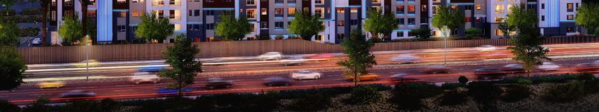
Insert Rendering - City of Phoenix
←
→
Page content transcription
If your browser does not render page correctly, please read the page content below
CASE Z-16-20-6

                  LOCATED APPROXIMATELY 600 FEET EAST OF THE
                              NORTHEAST CORNER OF
                       16TH STREET AND CAMELBACK ROAD

                                Insert Rendering

Date of Initial Submission: March 20, 2020
Second Submittal: September 8, 2020
Hearing Draft: October 14, 2020
City Council Adopted: December 16, 2020
Minor Amendment Approved: May 19, 2021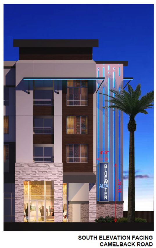
A Planned Unit Development (“PUD”) is intended to be a stand‐alone document
of zoning regulations for a particular project. Provisions not specifically regulated
by the PUD are governed by the Zoning Ordinance. A PUD may include substantial
background information to help illustrate the intent of the development. The
purpose and intent statements are not requirements that will be enforced by the
City. The PUD only modifies Zoning Ordinance regulations and does not modify
other City Codes or requirements. Additional public hearings may be necessary,
such as, but not limited to, right‐of way abandonments.

                                   Page 2 of 55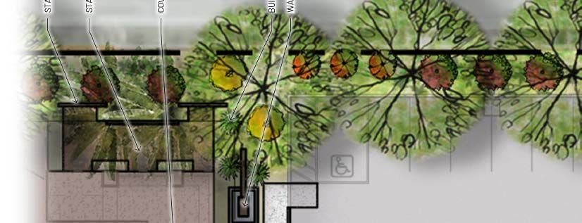
Principals and Development Team

Developer
Wood Partners
7975 N Hayden Road, Suite #A‐101
Scottsdale, AZ 85258
(480) 567‐0069
www.woodpartners.com

Architect
Biltform Architecture Group
11460 N Cave Creek Road, Suite 11
Phoenix, AZ 8520
(602) 285‐9200
www.biltform.com

Landscape Architect
ABLA
310 E Rio Salado Parkway
Tempe, AZ 85281
(480) 530‐0077
www.ablastudio.com

Civil Engineer
Wood Patel
2501 W Northern Avenue, Suite 100
Phoenix, AZ 85021
(602) 335‐8500
www.woodpatel.com

Traffic Engineer
CivTech, Inc.
10605 N Hayden Road, Suite 140
Scottsdale, AZ 85260
(480) 659‐4250
www.civtech.com

Zoning Attorney
Nick Wood, Esq.
Snell & Wilmer, LLP
One Arizona Center
Phoenix, AZ 85004
602‐382‐6269
www.swlaw.com

                                    Page 3 of 55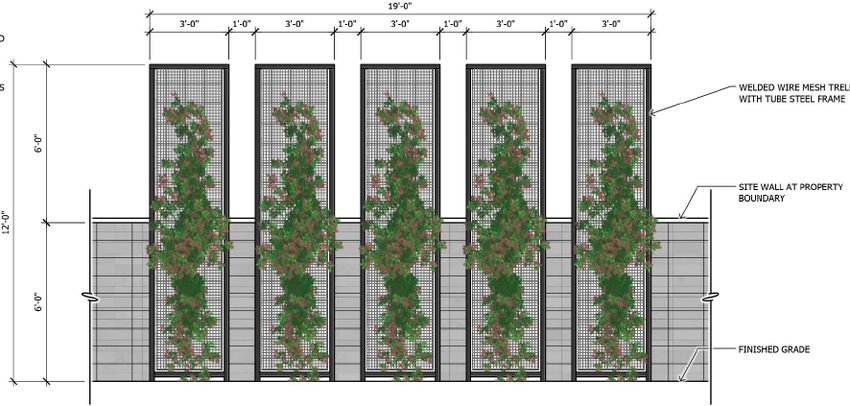
Table of Contents                        Page #

A. Purpose and Intent                      5
B. Land Use Plan                           9
C. List of Uses                            10
D. Development Standards                   11
E. Design Guidelines                       16
F. Signs                                   19
G. Sustainability                          21
H. Infrastructure                          22
I. Comparable Zoning Standards Table       24
I. Legal Description                       25

List of Exhibits

Exhibit A: Site Plan                       30
Exhibit B: SR‐51 Property Line Exhibit     31
Exhibit C: Landscape Plan                  32
Exhibit D: Amenity Plan                    33
Exhibit E: Rendering                       34
Exhibit F: Color Elevations                35
Exhibit G: Conceptual Entry Design         39
Exhibit H: Camelback East SP Matrix        40

                                          Page 4 of 55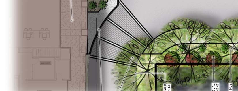
A. PURPOSE AND INTENT

A1: Project Overview and Goals

Located in the Camelback‐Biltmore area, one of the most prestigious locations in the Valley, Alta
Bluewater is a distinctive 216 unit, five (5) story luxury rental residential community that will
provide a high‐quality living environment for those that desire to live near their place of work
(there is over 7.9 million square feet of office space in the area1) as well as all of the shopping,
dining and entertainment located in the immediate vicinity. The primary goal of the Project is to
provide a quality modern urban living experience, both internally (amenities, unit finishes and
tenant services) and externally (by proximity to a full live/work/play environment) for its future
residents and to create a visually pleasing structure as this is a site situated along one of Phoenix’s
most significant thoroughfares.

A2: Overall Design Concept

The design is focused on the creation of a “modern luxury” environment, complementing the
built environment in the Camelback East Village and following a development trend that has
reinvented this area with higher density urban living, the redevelopment of underutilized
properties (especially surface parking lots) and an emphasis on quality design that has visual
interest from both Camelback Road as well as for those traveling SR‐51. Further, the Project’s
design provides for a building of comparable height and scale to those in the surrounding area,
including new multifamily projects along 16th Street as well as the Biltmore Square
Condominiums directly to the north of the Site.

To support the “modern luxury” concept, vehicle parking is located within a fully wrapped parking
structure (except for a few spaces near the entrance intended primarily for visitors, taxi and ride
share use).

As a residential environment, the elevations focus on the expression of the dwelling units, with
a contemporary modern design that features the extensive use of brick and stone veneers,
textured fiber cement siding, use of a varied light, midrange and dark color palette as well as
movement in the elevation at the base, middle and top of the structure with a number of square
“units” of for alternating size and scale. This design will complement the abutting Camelback
Center shopping plaza, which utilizes a mix of color, metal details and veneers, along with varying
square elements, but will be differentiated by a bolder color palette and utilization of extensive
window fenestrations.

In summary, the overall design concept is a building that (i) fits the surrounding scale by
maintaining similar heights as its neighbors, (ii) eliminates wasteful and unsightly surface parking

1
    https://www.phoenix.gov/econdevsite/Documents/Camelback%20Biltmore%20Employment%20Center.pdf

                                                         Page 5 of 55
areas by providing structured parking that is wrapped by the building and not visible from the
street, and (iii) the expression of the Camelback East area’s reputation for a quality built
environment via a rich blend of materials and colors combined with contemporary design that is
distinguished from its neighbors while retaining a complementary visual relationship.

A3: Compliance with the Camelback East Primary Core Specific Plan

As part of the Camelback East Primary Core Specific Plan (the “Plan”) identified as a “Core
Gradient” area (classified as “Core Gradient 22”), Alta Bluewater furthers the vision of the Plan
an implements specific the components of the Plan’s Design Guidelines, Section 5.4.4, specifics
of which are further detailed in the “Camelback East Village Planning Committee Application
Review Committee” comment form, provided in Exhibit H.

The site is unique in that it has a narrow frontage onto Camelback Road, with the building behind
an existing use (a gas station) as the lot widens 125 feet behind the edge of the right‐of‐way. The
site is also accessible via easements to the existing shopping center (to the west) and is not
accessible from the north (existing development) nor east (SR‐51). Anticipating a resident seeking
non‐vehicular mobility, the project includes a sidewalk system that runs through the Project and
connects to all amenity spaces, as well as to Camelback Road and the commercial center to the
west.

One key goal of the Plan is to address pedestrian access (the word pedestrian is found over 300
times in the Plan). To support the Plan’s call for a “pedestrian‐friendly environment3”, a primary
pedestrian route is provided directly to Camelback Road (for those coming from the east) and to
the shopping center’s walkway system (for those coming from the west), with the main
pedestrian entry being located at the southeast corner of the building. This entry is clearly
identifiable4 through the use of over‐height and emphasized architectural features (storefront
glass, double‐doors and a change in brick veneer).

To create a strong sense of arrival, once in the structure, pedestrians enter a double height
“Outdoor Room” (flex clubhouse space that has sliding doors to expand out into the pool
courtyard). The building entry area will be visually dramatic, with the doors surrounded by glass
storefront, architectural detailing at the ceiling and views through the building out to the pool
area. This Outdoor Room continues an uninterrupted expanse of landscape and hardscape from
the exterior pedestrian linkage with extensive shading and contemporary outdoor furnishings.
By tying indoor semi‐private space with outdoor public pathways, Alta Bluewater will provide a
quality on‐site pedestrian experience, encouraging pedestrian activity in the area and
discouraging automobile use for short trips, as desired by the Plan5.

2
  Map 4, Page 28 of the Plan
3
  Section 1.1, Page 10 of the Plan – discussion of the origin of the Plan and noting a community “desire to create…a pedestrian‐friendly
environment.”
4
  Section 2.6, Page 19 of the Plan ‐ “Pedestrians should be able to identify building entrances easily and access buildings directly from the
street…”
5
  Section 2.6, Page 19 of the Plan – “There should be plenty of places to live within easy walking distance of the Core’s many attractions.”

                                                                  Page 6 of 55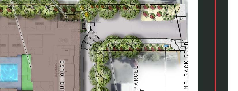
Water is an important theme to the Project, giving homage to the site’s former use (a seafood
restaurant) and offering a welcome respite from the desert streetscape. A carefully designed
water feature is situated along the pedestrian linkage, enriching the pedestrian experience, as
recommended in the Plan6. Blue colored artistic lighting on the building and within the signage
contribute to the theme. Inclusion of water within the pedestrian realm further supports a quality
pedestrian experience on‐site.

In addition to giving greater priority to pedestrians7, due to its location, amenities, and overall
design, Alta Bluewater also furthers many of the Plan’s other goals, including providing new
places for people to live in the Core8 as well as allowing people to “maintain a high‐quality
residential lifestyle” (Page 19 of the Plan).

Alta Bluewater also satisfies the Plan’s regulatory components, which implement the goals noted
above. It complies with Table B, Table of Building Height and Floor Area Ratio (Page 28) for a Core
Gradient 2 parcel by maintaining a maximum height of 56 feet9. It also complies with the
regulations of Section 5.2. Section 5.2.4 codifies the applicable development standards as found
on Table E, which provides the following development standards to the Alta Bluewater site:

                                                        Development Standard
                                                     Lot                            Step Back from            Open        Parking Spaces
        Density           Building Height                          Setbacks
                                                  Coverage                           Single‐Family            Space         Required
      96.8 dwelling     Residential: per    Per         Per    Per underlying      Per                                      Per Section
    units per acre for underlying zoning underlying underlying   zoning and     Ordinance                                       702
     development        with max height    zoning     zoning presumptive design
    over four stories    of 56' allowed                        guideline B.2.3

This PUD establishes the “underlying zoning” for the site and complies with the density, height,
open space and parking required by the Plan as noted above.

The Plan includes incentive elements that seek to encourage specific design features in certain
development scenarios. This PUD supports these goals of the Plan by including several of the
“High” rated desired amenities identified in Section 5.3.5, Table F, including:

          (i) High Density Housing (High Desirability)
                  Meets – project provides 216 dwelling units at 64.5 dwelling units per acre.

          (ii) Extraordinary Design Quality (High/Medium Desirability)

6
  Section 5.4.4.A.3.4.2, Page 70 – “Fountains and other forms of water features enhance the pedestrian environment with the splash, sprinkle
and reflections of moving water while masking the sounds of vehicle traffic from the surrounding streets and driveways. In warm weather, water
in motion and in still pools provides a pleasurable sense of coolness.”
7
  Section 2.6, Page 18 of the Plan – “Pedestrians should be given greater priority”
8
  Section 2.6, Page 18 of the Plan – “People should be encouraged to live within…the Core and be able to select from a broad range of housing
types.” and Page 19 of the Plan, “There should be plenty of places to live within easy walking distance of the Core’s many attractions.”
9
  The City of Phoenix no longer utilizes “stories” as a height control, therefore such story restrictions are not applicable.

                                                                Page 7 of 55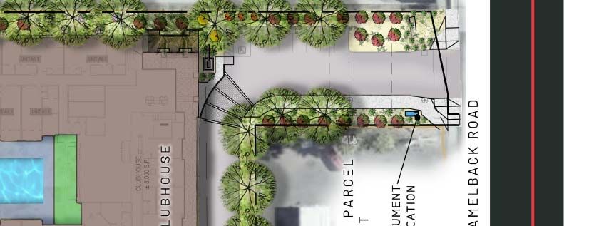
Meets – project provides a modern design with emphasis on an updated urban
       vernacular including bold use of color, material and patterns in the elevations.

(iii) Exceptional Mitigation of Structured Parking Design (High Desirability)
         Meets – project parking garage is enclosed within the building, fully wrapped with
         units and not visible from public rights of way.

(iv) Creation of Extraordinarily Enhanced Pedestrian Areas with Project (High Desirability)
        Meets – project provides direct linkages to Camelback Road as well as to abutting
        retail shopping and dining.

                                    Page 8 of 55
B. LAND USE PLAN

B1: Proposed Land Use Categories

The Project is proposed as a residential luxury multi‐family community of up to 216 dwellings
and supporting private resident amenities.

B2: Conceptual Site Plan Summary

The following provides an overview of the conceptual site plan provided with this PUD:

Grade Level is the location of the primary access to the Site, along with a few surface parking
spaces reserved for guests, ride share and prospective tenants of the project. At the southern
end of the Site is the main entrance to the building and its amenity facilities. Pedestrian linkages
are provided from Camelback Road and the adjoining retail center into the main clubhouse. The
entrance to the structured parking is provided near the northwestern portion of the building.
Connections to the adjoining commercial drive aisles are provided, offering two other points of
access to and from the Site. The grade level of the structure also features residential units,
accessed from internal corridors within the building. Landscaping is provided to enhance the
entry drive from Camelback Road, as well as to soften the edge along SR‐51 and the area between
this project and the existing carriage units (part of the development to the north). The main
resident outdoor amenity space is provided in the southern core of the building.

Levels 2‐4 are typical representation of the upper levels of the building. Here the residential
dwelling units continue above the grade level podium. As the resident dwelling focused areas of
the Project, there are no amenities on these upper levels. Note that the development is a mix of
one‐ and two‐bedroom units, ranging in size from 677 up to 1,224 square feet.

Level 5 will have additional residential units configured in a manner similar to levels 2‐4. Level 5
will also feature a Club Deck, approximately 800 square feet in size. The Club Deck will feature
amenities such as an outdoor kitchen, seating areas and decorative lighting. The Club Deck will
be shaded by a roof projection and will be architecturally integrated into the building façade.

Roof Level will not be occupiable.

                                             Page 9 of 55
C. LIST OF USES
C1: Permitted Uses
Multi‐Family Residential Dwelling Units as Governed Herein
C‐2 Uses as Permitted by Section 623 of the City of Phoenix Zoning Ordinance are
subject to all listed conditions in said section.
C2: Temporary Uses
All temporary uses shall comply with Section 708 of the City of Phoenix Zoning
Ordinance
C3: Prohibited Uses
The following land uses are not permitted:
All Special Permit uses otherwise permitted in the C‐2 Zoning District are prohibited.
Auto Title Loan Establishments
Automobile Parts and Supplies, New Retail and Wholesale
Boats, Retail Sale
Car Wash
Compressed Natural Gas Retail Sales
Gas Stations
Garage, Repair
Hospital
Motorcycles, Repair and Sales
Nonprofit Medical Marijuana Dispensary Facility
Pawn Shop
Service Stations, Automobile
Tobacco Oriented Retailers
Veterinarian Offices
Veterinarian Hospitals
Window Glass Installation Shop
Page 10 of 55D. DEVELOPMENT STANDARDS
D1: Development Standards Table
The following development standards apply to any multifamily development of the Property; in
the event non‐multifamily development occurs, the development standards applicable to such
development shall be those of Section 623, the C‐2 General Commercial, Zoning District.
a. Maximum Residential Unit Count
Maximum Dwellings 216 dwelling units
Maximum Density 64.5 dwelling units per acre
b. Minimum Lot Width/Depth No Minimum
c. Minimum Building Setbacks From Property Line
North (Internal Property Line) 10’
West (Internal property Line) 25’
South (Camelback Road) 125’
South (Internal Property Line) 25’
East (State Route 51) 10’10
d. Minimum Parking Setbacks 10’
d. Maximum Building Height 56 Feet
e. Maximum Lot Coverage 65% of Total Net Site Area
D2: Landscape Standards Table
Minimum Landscape Setbacks
North (Internal Property Line) 10’ Landscape Setback
West (Internal Property Line) 0’ Landscape Setback
South (Camelback Road) 50’ Landscape Setback11
South (Internal Property Line) 10’ Landscape Setback
East (State Route 51) 10’ Landscape Setback12
10
The building setback may be reduced to zero (0) feet adjacent to the SR‐51 “ADOT” property line “notch” as
depicted in Exhibit B.
11
For portions of this area subject to an existing SRP easement, restrictions on plantings by SRP supersede any
requirements of this PUD.
12
The landscape setback may be reduced to zero (0) feet adjacent to the SR‐51 “ADOT” property line “notch” as
depicted in Exhibit B.
Page 11 of 55Minimum Landscape Standards
a. Streetscape ‐ Adjacent to 50% 2”‐caliper trees; 25% 3”‐caliper trees; 25% 4”‐caliper
Camelback Road (South Property trees planted 20' O.C. or in equivalent groupings, except
Line) for within driveways or sidewalks and excludes any areas
where existing easements restrict tree plantings.
Five (5) 5‐gallon drought‐resistant shrubs per tree.
Any open area not improved or hardscaped shall include
landscaping materials at a minimum of 75% living
Groundcover.
b. Perimeter Property Lines (North, 100% 2" Caliper Trees (or greater) planted 25' O.C. or in
East and West Property Line) equivalent groupings, except for within driveways or
sidewalks and excludes any area (i) along fire lane where
landscape area is not able to support trees and (ii) within
any easement required by SRP.
Five (5) 5‐gallon drought‐resistant shrubs per tree.
Any open area not improved or hardscaped shall include
landscaping materials at a minimum of 75% living
Groundcover.
Within the SRP easement areas on the north, west or east
property line, the following standards shall apply:
(i) provide a minimum 4‐foot‐wide natural grey scored
concrete walk, connected to either other pedestrian ways
or to an entry door.
(ii) provide vehicular rated liner paver patio areas for a
total of no less than 15% of total easement area.
(iii) for areas not improved with the above surfaces, plant
vegetation per the SRP approved plant list for their
easements. At maturity, said vegetation shall cover 75%
of the area not hardscaped.
(iv) along the eastern property line, provide a minimum
of two (2) locations of vine trellis with vines and two (2)
locations of accent panels to be installed near the
property boundary line within the SRP easement area.
Each location of vine trellis and accent panels are to be in
substantial conformance to the design below.
Page 12 of 55Within the SRP easement areas, Section D2.f and Section D4.a do not apply. Page 13 of 55
d. Minimum Common Open Space            A “Pool Courtyard” private common open space amenity
                                         shall be provided. Said amenity shall be a minimum of
                                         5,000 square feet. See Section D.5 for shade
                                         requirements and Section E.4 for amenity requirements.
 e. Minimum Total Open Space             Minimum of 8% of total Gross Site Acreage. May be
                                         located above grade. Excludes landscape setback areas.
 f. Plant Palette                        All plant materials shall consist of those listed on the
                                         Phoenix low‐water use plant list, and shall be consistent
                                         with the Biltmore landscape design theme. Further,
                                         selected plant materials shall be consistent with the
                                         “historic” plant palette of the “Old Phoenix” or “Arizona
                                         Biltmore” landscape theme, as outlined in the Specific
                                         Plan.

D3: Parking

 Parking Standards
 Minimum Parking Standards
                          a. Residents 1.3 spaces per unit
                b. Unreserved Visitor 0.35 spaces per unit
                    c. Bicycle Parking 0.25 spaces per dwelling unit
                                       (maximum requirement for bicycle parking is 50 spaces)
 Parking Location, Automotive          Resident parking shall be within a structured garage,
                                       located internal to the Site, as outlined in the Specific Plan
                                       in Section 6.2.1. Visitor, prospective tenant and/or
                                       clubhouse parking may be located in a surface parking lot,
                                       not to exceed a total of ten (10) spaces. Said parking lot
                                       shall not be located within the building setbacks (D1.c)
                                       except the South (Camelback Road) setback, in which
                                       case the setback shall be no less than 50’ feet.
 Parking Location, Bicycle             To be installed in conformance with Section 1307.H,
                                       except as follows: (i) Inverted‐U style bicycle racks or
                                       artistic style racks consistent with the City of Phoenix
                                       preferred designs (see Comprehensive Bicycle Master
                                       Plan, Appendix K) shall be provided and (ii) secure
                                       resident bike storage may be located within the parking
                                       garage.

                                            Page 14 of 55
D4: Shade
Shade
Building and Shade
Shading, which may be corporeal, vegetative or any combination thereof, shall be provided as
follows. All shade calculations shall be based on the summer solstice at noon.
a. Pedestrian Realm 75% minimum for north/south access sidewalk (from Camelback Road
(Sidewalk) Shading to Main Entry) unless existing easement prohibits installation of trees
and/or physical shading structures.
b. Amenity Courtyard 50% minimum of useable area. Total percentage required excludes
pool surface and pool deck area (the area within the pool fence
enclosure) and inaccessible elements (such as raised planters,
fountains, etc.).
c. Surface Parking Lots Two (2) inch caliper shade trees shall be provided at the ends of each
parking row, unless existing easement prohibits installation of trees.
Page 15 of 55E. DESIGN GUIDELINES
E1: Design Guidelines. The following design guidelines shall be provided for in the final plans for
a multi‐family structure (non‐residential development shall comply with Section 507 Tab A, and
with Design Guidelines found in the Camelback East Primary Core Specific Plan):
a. Exterior Materials – Quality elevations require the use of a variety of materials, particularly
in the details of the façade design. All sides of the building shall exhibit four‐sided
architecture. To achieve this, the following standards apply:
Materials for the external façade may include:
o Concrete
o Masonry
o Brick or Stone Veneer
o Non‐reflective coated metals
o Stucco
o Wood, painted or stained
o Tile
o Rough Textured Fiber Cement Siding
Of these materials, there shall be no less than three (3) different materials utilized on
each façade.
Use of Stucco is limited to no more than 60% of the building elevation.
b. Color Palette – Colors should be as illustrated on the color and materials palette included
with this PUD application.
c. Mechanical Equipment Screening Methods. Rooftop mechanical unit screens shall obscure
visible sides of the roof top equipment by use of one (1) or more of the following methods to
screen equipment:
Building parapets.
Independent, structurally supported screen walls providing screening for rooftop
mechanical equipment when the parapet is lower than the mechanical units.
Removable decorative panels.
Other enhanced features comprised of complementary building materials.
d. Parking Garage – The parking garage shall be internal to the site and be fully screened by (i)
being wrapped by dwelling units and/or (ii) including façade features that are architecturally
integrated to appear part of the overall building façade. No freestanding detached parking
garages are permitted.
Page 16 of 55E2: Landscape Design Guidelines. The primary goal of the Conceptual Landscape Plan is to soften
the building’s exterior between the existing residential units to the north and to enhance the
appearance from SR‐51. To accomplish this goal, the following requirements apply to multi‐
family residential development (non‐residential development shall comply with Section 507 Tab
A and Section 623 of the Phoenix Zoning Ordinance):
a. Uniform Perimeter Design ‐ The perimeter shall be developed to have a consistent look and
shall include the following:
Use of a mix of flowering desert shrubs and groundcovers.
All screen walls will include architectural detailing consistent or complementary to the
building facade.
Along the north, west and east facades, use of desert drought‐tolerant trees.
b. Pedestrian Pathway System Standards – Development shall include a pedestrian pathway
system that includes the following:
Provide one (1) or more pedestrian connections to the retail center to the west as well as
one (1) to Camelback Road. Such pedestrian connections shall be a minimum of five (5)
feet wide concrete walkways except where crossing driving surfaces, where decorative
pavers or stamped concrete will be utilized to emphasize the pedestrian pathway.
This pathway system shall provide direct connections between the following site
elements: sidewalks, where pedestrian paths cross drive aisles, bicycle facilities, building
entrances and exits.
The main pedestrian pathway that connects Camelback Road to the building entrance
shall be a minimum 8 feet wide and shall be shaded with trees to 75 percent at maturity
or physical structures, except as limited by existing easements. Pedestrian‐scale lighting
shall be provided along this path.
E3: Amenities Guidelines. The following amenities are required for multi‐family development:
a. Resident Amenities (in building)
Clubhouse/Event Space of no less than 5,000 square feet
Fitness Center of no less than 1,840 square feet
5th Floor Club Deck of no more than 800 square feet.
b. Resident Amenities
Swimming Pool and/or Spa of no less than 750 square feet
Water Feature Along Primary Pedestrian Route to/from the Building
In addition to the above, provide at least three (3) of the following:
Shaded outdoor dining area
Water feature(s)
Page 17 of 55Outdoor fitness area
Fire feature(s)
Seating node(s) with two (2) benches or moveable site furnishings, and 1 alternative paving material
Art installation
Community Gardening Area that Includes Raised Garden Beds with Automatic Irrigation System
c. Public Amenities (at grade)
Provide at least two (2) of the following:
Bench Seating that Includes a Shade Element
Bike Racks
Public Art (Including decorative water features, which are exclusive of those provided under E4.b)
Decorative Paving Materials
Landscape Planters
Page 18 of 55F. SIGNS
F: Signs
Signage shall comply with the provisions found within Section 705 of the Zoning Ordinance,
except as otherwise permitted below.
Note that there is an existing monument sign for the larger commercial center located at the
southeast corner of the site near Camelback Road subject to a specific agreement titled “Sign and
Access Easement Agreement recorded at 2003‐1249826 in the records of the Maricopa County
Recorders Office. This PUD does not modify the applicable standards applicable to this sign under
the provisions of the Zoning Ordinance. No changes to this sign are proposed by this PUD nor
with subsequent redevelopment of the site. This sign shall not be counted as one of the allowed
site signs in the application of this section and/or the Zoning Ordinance to the project’s allowable
identification signage (i.e. if one sign is permitted, the existing monument sign does not count
towards that cap).
F.1: Building Signage
In addition to those signs otherwise permitted by Section 705 of the Zoning Ordinance, building
identification signage may include the following, as regulated herein.
a. Wall Signs (“Blade Style” projecting signs are permitted)
b. Monument Sign (located near entryway onto Camelback Road)
As the Site is subject to the Camelback East Primary Core Specific Plan, all signs will require
approval of a Comprehensive Sign Plan (“CSP”). This approval shall be processed through a
separate application.
F.2: Wall Signs.
The project may have up to two (2) wall signs (of a “blade sign” type, projecting from the building
façade), limited to (i) 25 feet maximum length, (ii) 4 feet maximum width and (iii) a total of 94
square feet of area. Such signs may be internally lit.
F.3: Camelback Road Monument Sign
Due to the narrow exposure to Camelback Road, need to maintain proper sight visibility distances
for traffic safety, and an existing monument sign for the neighboring retail center, careful
placement in design of project identification is critical to provide directional information to future
residents and guests, particularly given the significant setback from Camelback Road to the
building. To address these factors, the following standards shall apply to this sign:
Page 19 of 55F.2a: Camelback Road Monument Sign Standards
Sign Requirements Signage Design Concept
1.Maximum Height 8’‐0”
2. Maximum Base Width 3’‐0”
3. Maximum Base Depth 8’‐0”
4. Maximum Area Per Face 32 Square Feet
5. Minimum Setback from 5’‐0”
Camelback Road Property
Line
6. Design Standards Must utilize at
least two (2) of
the following
materials:
Brick
Brushed
Aluminum
Rolled
Steel
Stucco
7. Location Near Camelback
Road, setback at
least 5 feet from
ROW.
Page 20 of 55G. SUSTAINABILITY
G1: City Enforced Standards
The following are standards that are measurable and enforceable by the City and will be
provided:
Recycling receptacles and chutes will be provided in the refuse room.
Bicycle parking for multi‐family residential shall be provided in a secured location which
may include individual lockers or racks. At least one area will be accessible within 250‐
feet from the street. The location and dimension of bike racks is subject to the City’s
approval during the technical site plan review process.
All primary site lighting will be LED lighting.
G2: Developer Enforced Standards
The following are sustainability practices that are highly encouraged and planned to be utilized
but which are not enforceable by the City:
Provide water efficient landscaping (drought tolerant plants).
Utilize a drip irrigation system with a ‘smart’ controller to minimize water waste.
Utilize low water usage plumbing fixtures.
Encourage the design of buildings’ HVAC systems to eliminate the usage of CFC’s and CFC
based refrigerants.
Encourage the use of water‐based adhesives on all VCT and vinyl flooring to minimize VOC
off gassing.
Lower flow toilets and showerheads.
Energy Star Rated appliances.
Use of synthetic turf (outside of any landscape setback) on podium.
On‐site amenities and activity programs to encourage residents to remain on property,
reducing off‐site traffic trips.
Page 21 of 55H. INFRASTRUCTURE
H1: Grading and Drainage
The subject property is not currently located within a FEMA special flood hazard zone and is not
impacted by offsite storm water flows. Grading will be limited to the property with the intent of
matching existing elevations at the perimeter.
Existing site drainage methodology allows storm water to sheet flow across the surface with
some underground piping to above‐ground retention basins utilizing drywells for disposal. In the
developed condition, storm water retention must be provided for the difference between the
pre‐developed and post‐developed runoff from a 100‐year, 2‐hour storm event. It is anticipated
that retention will be provided in underground corrugated metal or concrete tanks. A small
diameter storm drain collection system will capture and convey storm water from building roof
drains, site concentration points and proposed open spaces to the tanks. Dual chamber drywells
will be utilized to drain the retained storm water within the required period.
H2: Water and Wastewater
The existing property is served by a City of Phoenix 8‐inch public sewer main, draining west in
Medlock Drive. The proposed onsite improvements will include a vitrified clay pipe (VCP) sanitary
sewer service to the existing Medlock Drive sewer, which terminates at manhole located in the
northwest corner of the property.
Medlock Drive contains an existing 8” public water main within pressure Zone 1 that terminates
approximately 215 feet west of the property. This waterline is inaccessible from the property.
Based on City of Phoenix mapping, the north end of the property contains a sub‐standard, public
small diameter water loop. It is understood that a section of this small diameter system serves
the adjacent property to the west. The potential of replacing this existing Zone 2A 4” public water
loop with a single new 4” water line should be explored with the city during final design. Per the
City of Phoenix, this system cannot be utilized for the proposed development.
Camelback Road contains separate 12” and 8” existing public water mains within pressure Zone
1. An existing 6” fire line extends north into the site from the 12” diameter Camelback waterline.
An existing ¾” water service also extends to the Bluewater Grill building from Camelback Road.
Domestic, landscape and fire protection water service for the proposed development shall be
extended from the Camelback Road pressure Zone 1 system. Additional hydrants may be
required onsite for adequate coverage of the proposed development.
Page 22 of 55H3: Circulation Systems
The adjacent public roadway (Camelback Road) is built to a full public standard and is at its final
build‐out size and configuration. No changes are proposed for this roadway. Site access is
provided by (i) a driveway onto Camelback Road, (ii) into and across the retail shopping center
via easement rights which accesses additional driveways onto Camelback Road and 16th Street
and (iii) via the back side of the retail center to both Medlock Drive and 16th Street. Based on the
provided Traffic Impact Statement (under separate cover), the project proposed by this PUD is
not anticipated to negatively impact existing roadway capacities.
H4: Complete Streets
The City of Phoenix Complete Streets Design Guidelines include a number of suggestions for new
development, some of which are applicable to this project. Specifically, this project will forward
the “Design for Safety” and “Design for Connectivity” recommendations by its location, and
inclusion of an emphasized pedestrian pathway network to encourage pedestrian movements
to/from the adjacent retain center, the project will identify where pedestrians are crossing
automotive pathways to reduce conflicts.
Page 23 of 55I. COMPARATIVE ZONING STANDARDS TABLE
I: Comparative Zoning Standards Table
Comparative Zoning Standards Table
Proposed PUD
Standards C‐2 Standards P‐1 Standards Standards
623.E.1 refers to R‐3 (Section 639.A.B.1 refers to
615) Section 702
a. Minimum Lot Dimensions
(Width and Depth) 60' width, 94' depth None None
14.5 Dwelling Units Per Acre
b. Dwelling Unit Density (Modified by Specific Plan to 216 Dwelling Units
(Units/Gross Acre) 96.8 du/ac) None (81 du/ac)
c. Perimeter Standards 20' Front; 15' Rear; 10' Side None None
d. Building Setbacks
25' Front None 125'
15' Rear None 10'
5' Sides None 25' West/10' East
e. Landscape Setbacks
25' Front None 25'
5' Rear None 10'
5' Sides None 0' West/10' East
2 Stories of 30' for First 150'; 1'
in 5' Increase to 48' High, 4‐
Story Maximum (Modified by
e. Maximum Height Specific Plan to 56') None 56 Feet
f. Lot Coverage 45% None 65%
Minimum 8% of
g. Common Areas Minimum 5% of Gross Area None Gross Area
Page 24 of 55J. LEGAL DESCRIPTION
I. Legal Description:
DESCRIPTION (NCS-995489-ATL)
The Land referred to herein below is situated in the County of Maricopa, State of Arizona, and is
described as follows:
THAT PORTION OF THE "BILTMORE SQUARE CONDOMINIUMS, A CONDOMINIUM,"
LYING SOUTH OF THE NORTH LINE
OF THE SOUTHEAST QUARTER OF THE SOUTHWEST QUARTER OF THE
SOUTHWEST QUARTER OF SECTION 15,
TOWNSHIP 2 NORTH, RANGE 3 EAST OF THE GILA AND SALT RIVER BASE AND
MERIDIAN ACCORDING TO THE PLAT
OF RECORD IN THE OFFICE OF THE COUNTY RECORDER OF MARICOPA COUNTY,
ARIZONA, IN BOOK 2 OF MAPS, PAGE
1, AND, BEING A PORTION OF LOT 14 "ADAMS & GRAHAM SUBDIVISION," OF THE
SOUTH HALF OF SECTION 15,
TOWNSHIP 2 NORTH, RANGE 3 EAST OF THE GILA AND SALT RIVER BASE AND
MERIDIAN ACCORDING TO THE PLAT
OF RECORD IN THE OFFICE OF SAID COUNTY RECORDER OF MARICOPA COUNTY,
ARIZONA, IN BOOK 2 OF MAPS,
PAGE 1;
COMMENCING AT THE NORTHWEST CORNER OF SAID LOT 14, BEING THE
NORTHWEST CORNER OF THE SOUTHEAST
QUARTER OF THE SOUTHWEST QUARTER OF SAID SOUTHWEST QUARTER OF
SECTION 15;
THENCE NORTH 89 DEGREES 41 MINUTES 44 SECONDS EAST (BASIS OF
BEARINGS), ALONG THE NORTH LINE
THEREOF, SAID NORTH LINE ALSO BEING THE SOUTH LINE OF SAID "BILTMORE
SQUARE CONDOMINIUMS, A
CONDOMINIUM," A DISTANCE OF 206.38 FEET TO THE TRUE POINT OF BEGINNING;
THENCE CONTINUING ALONG SAID NORTH LINE, NORTH 89 DEGREES 41
MINUTES 44 SECONDS EAST, A DISTANCE OF
19.32 FEET TO A POINT ON THE WEST RIGHT-OF-WAY LINE OF STATE ROUTE 51;
THENCE ALONG SAID WEST RIGHT-OF-WAY LINE OF STATE ROUTE 51, SOUTH 00
DEGREES 27 MINUTES 13 SECONDS
WEST, A DISTANCE OF 248.71 FEET;
THENCE CONTINUING ALONG SAID WEST RIGHT-OF-WAY LINE OF STATE ROUTE
51, SOUTH 89 DEGREES 17 MINUTES
13 SECONDS EAST, A DISTANCE OF 2.51 FEET;
THENCE CONTINUING ALONG SAID WEST RIGHT-OF-WAY LINE OF STATE ROUTE
51, SOUTH 00 DEGREES 26 MINUTES
Page 25 of 5538 SECONDS WEST, A DISTANCE OF 13.77 FEET TO A POINT ON THE SOUTH LINE
OF "HUNTCROFT UNIT TWO,"
ACCORDING TO THE PLAT OF RECORD IN THE OFFICE OF SAID COUNTY
RECORDER OF MARICOPA COUNTY, ARIZONA,
IN BOOK 63 OF MAPS, PAGE 50;
THENCE ALONG SAID SOUTH LINE, SOUTH 89 DEGREES 41 MINUTES 44 SECONDS
WEST, A DISTANCE OF 39.73 FEET;
THENCE NORTH 00 DEGREES 00 MINUTES 14 SECONDS EAST, A DISTANCE OF
131.25 FEET;
THENCE NORTH 89 DEGREES 41 MINUTES 44 SECONDS EAST, A DISTANCE OF 19.96
FEET;
THENCE NORTH 00 DEGREES 00 MINUTES 14 SECONDS EAST, A DISTANCE OF
131.25 FEET TO THE TRUE POINT OF
BEGINNING.
DESCRIPTION (NCS-990413-PHX1)
The Land referred to herein below is situated in the County of Maricopa, State of Arizona, and is
described as follows:
PARCEL NO. 1:
LOTS 111, 112, 113, 114 AND 115, HUNTCROFT UNIT TWO, ACCORDING TO BOOK 63
OF MAPS, PAGE 50, RECORDS OF MARICOPA COUNTY, ARIZONA;
EXCEPT THAT PORTION OF LOT 115 LYING EAST OF THE FOLLOWING DESCRIBED
LINE DESIGNATED HEREIN AS LINE A;
BEGINNING AT THE SOUTHEAST CORNER OF SAID LOT 115;
THENCE SOUTH 89 DEGREES 41 MINUTES 20 SECONDS WEST ALONG THE SOUTH
LINE OF SAID LOT 115, A DISTANCE OF 20.00 FEET TO THE POINT OF BEGINNING;
THENCE NORTH 00 DEGREES 00 MINUTES 10 SECONDS WEST, A DISTANCE OF
97.93 FEET TO A POINT ON THE SOUTHERLY LINE OF PASADENA AVENUE AND
THE POINT OF TERMINATION.
PARCEL NO. 2:
THAT PORTION OF THE ABANDONED ALLEYS THAT IS CONVEYED BY OPERATION
OF LAW AS SET FORTH IN RESOLUTION NO. 17663 OF THE CITY OF PHOENIX,
RECORDED APRIL 13, 1990 IN RECORDING NO. 90-164706, RECORDS OF MARICOPA
COUNTY, ARIZONA, DESCRIBED AS FOLLOWS:
BEGINNING AT THE NORTHEAST CORNER OF LOT 111 IN SAID HUNTCROFT UNIT
TWO;
THENCE WEST ALONG THE NORTH LINE OF SAID LOT 111 AND ALONG THE
NORTH LINE OF LOT 112 IN SAID HUNTCROFT UNIT TWO TO THE MOST
NORTHERLY NORTHWEST CORNER OF SAID LOT 112;
THENCE SOUTHWESTERLY ALONG THE LOT LINE OF SAID LOT 112 TO THE MOST
Page 26 of 55WESTERLY NORTHWEST CORNER THEREOF;
THENCE SOUTH ALONG THE WEST LINE OF SAID LOT 112, AND THE WEST LINE OF
LOT 113 AND THE WEST LINE OF LOT 114 IN SAID HUNTCROFT UNIT TWO TO THE
MOST WESTERLY SOUTHWEST CORNER OF SAID LOT 114;
THENCE SOUTHEASTERLY ALONG THE LOT LINE OF SAID LOT 114 TO THE MOST
SOUTHERLY SOUTHWEST CORNER THEREOF;
THENCE EAST ALONG THE SOUTH LINE OF SAID LOT 114 AND ALONG THE SOUTH
LINE OF LOT 115 IN SAID HUNTCROFT UNIT TWO TO THE SOUTHEAST CORNER OF
SAID LOT 115;
THENCE SOUTHERLY ALONG THE SOUTHERLY PROLONGATION OF THE EAST
LINE OF SAID LOT 115 TO THE SOUTH LINE OF THE NORTH 12.00 FEET OF THAT
PART OF THE WEST HALF OF LOT 14 IN SAID ADAMS AND GRAHAM SUBDIVISION
OF THE SOUTHWEST QUARTER OF SECTION 15, TOWNSHIP 2 NORTH, RANGE 3
EAST, LYING SOUTH OF AND ADJOINING THE SOUTH LINE OF SAID HUNTCROFT
UNIT TWO;
THENCE WEST ALONG LAST SAID SOUTH LINE AND ALONG ITS WESTERLY
PROLONGATION TO THE WEST LINE OF THE EAST 8.00 FEET OF LOT 13 IN SAID
ADAMS AND GRAHAM SUBDIVISION;
THENCE NORTH ALONG LAST SAID WEST LINE AND ALONG ITS NORTHERLY
PROLONGATION TO THE SOUTH LINE OF LOT 90 IN HUNTCROFT, ACCORDING TO
BOOK 59 OF MAPS, PAGE 16;
THENCE EAST ALONG THE SOUTH LINES OF LOTS 90, 89, 88 AND 87 ALL IN SAID
HUNTCROFT TO THE NORTHERLY PROLONGATION OF THE EAST LINE OF SAID
LOT 111 OF HUNTCROFT UNIT TWO;
THENCE SOUTHERLY ALONG LAST SAID PROLONGATION TO THE POINT OF
BEGINNING.
EXCEPT ANY PORTION THEREOF LYING WITHIN BILTMORE SQUARE
CONDOMINIUMS AS RECORDED IN BOOK 753 OF MAPS, PAGE 28, RECORDS OF
MARICOPA COUNTY, ARIZONA; AND ALSO
EXCEPT ANY PORTION THEREOF LYING WITHIN LOT 13 OF ADAMS AND GRAHAM
SUBDIVISION AS RECORDED IN BOOK 2 OF MAPS, PAGE 1, RECORDS OF
MARICOPA COUNTY, ARIZONA; AND ALSO
EXCEPT ANY PORTION THEREOF LYING BELOW THE SOUTH LINE OF THE NORTH
284.50 FEET OF THE WEST HALF OF LOT 14, OF SAID ADAMS AND GRAHAM
SUBDIVISION.
PARCEL NO. 3:
THAT PORTION OF THE ABANDONED ROADWAY AS SET FORTH IN RESOLUTION
NO. 17663 OF THE CITY OF PHOENIX, RECORDED APRIL 13, 1990 IN RECORDING
NO. 90-164706, RECORDS OF MARICOPA COUNTY, ARIZONA, DESCRIBED AS
FOLLOWS:
THAT PART OF PASADENA AVENUE WITHIN HUNTCROFT UNIT TWO, ACCORDING
TO THE PLAT OF RECORD IN THE OFFICE OF THE COUNTY RECORDER OF
MARICOPA COUNTY, ARIZONA, IN BOOK 63 OF MAPS, PAGE 50 THAT LINES WEST
Page 27 of 55OF THE SOUTHERLY PROLONGATION OF THE EAST LINE OF LOT 111 IN SAID
HUNTCROFT UNIT TWO;
EXCEPT THAT PORTION OF LOT 115 LYING EAST OF THE FOLLOWING DESCRIBED
LINE DESIGNATED HEREIN AS LINE A;
BEGINNING AT THE SOUTHEAST CORNER OF SAID LOT 115;
THENCE SOUTH 89 DEGREES 41 MINUTES 20 SECONDS WEST ALONG THE SOUTH
LINE OF SAID LOT 115, A DISTANCE OF 20.00 FEET TO THE POINT OF BEGINNING;
THENCE NORTH 00 DEGREES 00 MINUTES 10 SECONDS WEST, A DISTANCE OF
97.93 FEET TO A POINT ON THE SOUTHERLY LINE OF PASADENA AVENUE AND
THE POINT OF TERMINATION.
EXCEPT ANY PORTION THEREOF LYING WITHIN BILTMORE SQUARE
CONDOMINIUMS AS RECORDED IN BOOK 753 OF MAPS, PAGE 28, RECORDS OF
MARICOPA COUNTY, ARIZONA.
PARCEL NO. 4:
THE EAST 8 FEET OF THE NORTH 274.5 FEET OF LOT 13, ADAMS AND GRAHAM
SUBDIVISION, RECORDED IN BOOK 2 OF MAPS, PAGE 1, RECORDS OF MARICOPA
COUNTY, ARIZONA.
PARCEL NO. 5:
EASEMENT RIGHTS AND OTHER INTERESTS IN REAL PROPERTY AS SET FORTH IN
THAT CERTAIN DOCUMENT ENTITLED SIGN AND ACCESS EASEMENT
AGREEMENT RECORDED SEPTEMBER 5, 2003 IN RECORDING NO. 20031249826,
RECORDS OF MARICOPA COUNTY, ARIZONA.
PARCEL NO. 6:
EASEMENT RIGHTS AND OTHER INTERESTS IN REAL PROPERTY AS SET FORTH IN
THAT CERTAIN DOCUMENT ENTITLED AMENDED AND RESTATED CROSS-ACCESS
EASEMENT AGREEMENT AND TEMPORARY CONSTRUCTION EASEMENT
RECORDED SEPTEMBER 8, 2003 IN RECORDING NO. 20031256094, RECORDS OF
MARICOPA COUNTY, ARIZONA.
DESCRIPTION (NCS-991613-PHX1)
The Land referred to herein below is situated in the County of Maricopa, State of Arizona, and is
described as follows:
TRACT 1 FEE:
THE WEST HALF OF LOT FOURTEEN (14), IN THE SOUTHWEST QUARTER OF
SECTION FIFTEEN (15), ADAMS &
GRAHAM SUBDIVISION, OF THE SOUTH HALF OF SECTION FIFTEEN (15),
TOWNSHIP TWO (2) NORTH, RANGE THREE
Page 28 of 55(3) EAST OF THE GILA AND SALT RIVER BASE AND MERIDIAN ACCORDING TO
THE PLAT OF RECORD IN THE OFFICE
OF THE COUNTY RECORDER OF MARICOPA COUNTY, ARIZONA, IN BOOK 2 OF
MAPS, PAGE 1;
EXCEPT THE EAST 93.82 FEET; AND
EXCEPT THE WEST 150 FEET OF THE SOUTH 125 FEET THEREOF, AND
EXCEPT THE NORTH 262.5 FEET THEREOF, AND
EXCEPT THE NORTH 7 FEET OF THE SOUTH 40 FEET OF THAT PART OF THE
SOUTHWEST QUARTER SECTION 15,
TOWNSHIP 2 NORTH, RANGE 3 EAST, LYING WITHIN THE EAST HALF OF THE
WEST HALF OF SAID LOT 14, AND
EXCEPT THE NORTH 12 FEET OF THAT PART OF THE WEST HALF OF LOT 14, LYING
SOUTH OF AND ADJOINING THE
SOUTH LINE OF HUNTCROFT UNIT TWO, A SUBDIVISION RECORDED IN THE
MARICOPA COUNTY RECORDER'S OFFICE
IN BOOK 63 OF MAPS, PAGE 50, AS QUIT-CLAIMED TO THE CITY OF PHOENIX, BY
QUIT CLAIM DEED RECORDED
FEBRUARY 1, 1961 IN DOCKET 3573, PAGE 593, AND
EXCEPT THAT PROPERTY AS SET FORTH IN FINAL ORDER OF CONDEMNATION
RECORDED NOVEMBER 14, 1988 AS 88- 556740 OF OFFICIAL RECORDS.
TRACT 2 EASEMENT:
Easement rights and other interests in real property contained in that Cross-Access Easement
Agreement and Temporary Construction Easement recorded September 8, 2003 in Recording No.
20031256094, Records of Maricopa County, Arizona.
TRACT 3 EASEMENT:
Easement rights and other interests in real property contained in that Sign and Access Easement
Agreement recorded September 05, 2003 as 2003-1249826 of Official Records.
Page 29 of 55Page 30 of 55
Page 31 of 55
Page 32 of 55
Page 33 of 55
Page 34 of 55
Page 35 of 55
Page 36 of 55
Page 37 of 55
Page 38 of 55
"Planning with People for a Better Phoenix"

        Camelback East Village Planning Committee
          Application Review Committee (ARC)
   Camelback East Primary Core Specific Plan Design Guidelines Comments

PROJECT
DATE OF COMMENTS

  Camelback East Specific Plan                                     Applicant Comments Regarding
  Design Guideline                                                 Compliance

  A.3     Landscape Architecture

  3.1.1. Materials listed on the Phoenix low-water         P      Low-water plant materials are proposed within
  use plant list should be used within the right-of way.          the right-of-way.
  However, the selected plant material should
  contribute to the Biltmore landscape design theme.
  3.1.2 On private property, the existing "Old             P      A palette for the landscape areas is selected based
  Phoenix" or "Arizona Biltmore" landscape theme                  on the “historic” plant materials found in this list.
  should be continued and strengthened in the Core
  Center and Core Gradient through use of plant
  materials such as:

     TREES         SHRUBS                ACCENTS
     jacaranda     oleanders             roses
     Palms         privet                annuals
     olive trees   boxwood               jasmine
     eucalyptus    pyracantha            specimen
                                         cacti
     pepper        catclaw
     trees
     juniper       bougainvillea
     mesquite
     palo verde    GROUNDCOVERS
                   turf

  These and other "historic" plant materials should be
  used in combination with native plants and other
  low-water use landscape materials. This
  landscape theme features cacti and other native
  plants as exotics, setting them in a framework of
  plant materials historically used in the Core area.

                          Exhibit E - Camelback East Matrix
                                                  Page 39 of 55
Camelback East Specific Plan Applicant Comments Regarding
Design Guideline Compliance
3.4.1 An overall theme should be established for C N/A – “Gateways” are public improvements in public
the gateways with public input, by an artist or artist ROW to be done by the City of Phoenix
collaboration selected through the Phoenix Arts
Commission's public art guidelines and process.
An artist or artists should be involved in the design
and construction of all Core Gateways.
A. Core Gateways should be established
within the public right-of-way at:
1. 26th Street and Camelback Road;
2. 24th Street, south of Colter Avenue;
3. 24th Street at Highland Street;
4. Piestewa Peak Parkway and
Camelback Road (for Camelback
Road traffic)
5. Piestewa Peak Parkway and
Highland
B. Developers and other private sector C If the City of Phoenix identifies an area on the site
interests should be encouraged to abutting the ROW that it would like to have area for a
contribute to the development of the “gateway”, the developer is willing to discuss an
Gateways. easement or similar to provide a land donation towards
this goal.
C. Highest priority and symbolic importance C N/A – City initiated item.
should be given to the Camelback Road
Gateways.
D. Gateways should indicate the boundaries of C N/A – City initiated item.
special Core landscaping and streetscape
treatment.
3.4.2 Locate fountains and/or other water P A water feature is planned for the pedestrian spine.
features at those points along the pedestrian spine
where the highest concentrations of pedestrians
are anticipated engage in activities other than
walking through the area.
3.4.3 Developers should consider planning for C The project is proposing to include artistic lighting on
and installing public art within their projects or the the building, vertical and horizontal striped Blue
adjoining right-of-way and provide opportunities for colored LED lighting to be seen from Camelback Road
artist/designer collaborations in accordance with and the freeway.
the City's "Private Percent for Art Guidelines."
A.4 Open Space/Amenities
4.1 Shade and street furnishings should be P Benches and trash receptacles are provided.
provided for the comfort and convenience of
pedestrians especially within and/or adjoining the
pedestrian spine, (see Map 8 of Specific Plan).
Furnishings should include pedestrian lighting
fixtures and one or more of the following:
- drinking fountains
- benches
- trash receptacles
- information kiosks
Page 40 of 55Camelback East Specific Plan Applicant Comments Regarding
Design Guideline Compliance
4.2 The Location of active uses at ground level P While not a part of the Core “Pedestrian Spine,” a
in high-traffic pedestrian areas with particular pedestrian link connects from Camelback Road to the
emphasis along the pedestrian spine should be project’s front-door and its “outdoor room,” as well as
encouraged, including one or more of the following through an arcade to the existing retail center to the
west.
uses:
- retail
- restaurants (food and beverage)
- service (includes public, community
uses)
- entertainment
- outdoor room with eating options
- public art with kinetic movement or
descriptive interpretation narrative
- office space with visual interactive
glazing
- display windows or shadow boxes
4.3 Uses and activities P While the project is not part of the formal “pedestrian
that "spill out" into pedestrian spine,” the link is an extension of the public streetscape,
areas, especially those transitioning at the outdoor room into the building.
adjoining the pedestrian
spine (sidewalk cafes, etc.)
should be encouraged.
A. Open space provided in front of a building
should be an extension of the public streetscape
and act as a transition to the building.
4.4 Along the defined pedestrian spine, active, P A pedestrian walkway provides a series of pedestrian
pedestrian outdoor public spaces (a plaza, experiences linking the right-of-way access to the
courtyard, garden, "outdoor room," or a building and across to the existing retail center.
promenade) should be provided within private
developments and connected with pedestrian
walkways.
A.5 Trails/Pathways/Walkways
5.1 Continuous sidewalks or other pedestrian P Provided
walkways linking private developments with
sidewalks along public streets should be provided.
5.2 A continuous walkway system shall be as P This connectivity is provided, linking the pedestrian
shown on Map 8, pedestrian facilities plan. The destinations through the project site.
pedestrian spine should always be continuous and
provide connectivity between pedestrian
destinations, even if the alignment is modified.
5.3 Safe and convenient means of pedestrian P Not applicable as there are no abutting neighborhoods
access should be created between neighborhoods to access; the site is limited to no access north (existing
and the Core. condominiums) nor east (the SR-51 Freeway).
A. Access via other than public streets should
be provided if requested by the affected
homeowners association, with consent of
adjacent properties and if security
measures for the neighborhood are
addressed.
Page 41 of 55Camelback East Specific Plan Applicant Comments Regarding
Design Guideline Compliance
B. Access via public streets should be P Provided as shown on the site plan.
provided in the form of a continuous
sidewalk connecting all residential areas
within or adjacent to the Core Center or
Gradient to Camelback Road.
5.4 Vehicular access across the pedestrian P Access is limited to what is needed to link the parking
spine should be minimized. Exceptions may be
made for delivery access only, travel distance
around project perimeters on private property, and
for “main street” development that enhances the
pedestrian environment.
5.5. Pedestrian spine identity items and way- P Decorative hardscape and decorative lighting are to
finding aides shall be provided, including decorative provide way-finding aides.
hardscape, medallions, lighting standards and
luminaries
A.6 Parking/Circulation
6.1.1 Parking must be conveniently located, but C Most of the project’s parking is embedded in a parking
visually unobtrusive. structure within the building, hidden from view. Walls
A. Parking lots must be screened from street and landscaping screen the parking spaces at the
view with landscaping, berms, walls, grade pedestrian link.
changes or a combination of these
elements.
B. For office and retail commercial projects, P Not applicable
every parking space shall be no greater
than 150 feet from a sidewalk leading to the
building or from a building entrance, and
unshaded segments of walkways shall not
exceed 15 feet except at a driveway
crossing.
C. For all new development a minimum of 15% P Met.
of parking lot area must be landscaped with
trees and shrubs. For all expansions to
existing development, remodeling, or
additions, a minimum of 10% of parking lot
area must be landscaped. Minimum width
of landscape area is five feet (seven with
parking overhangs).
6.1.2 Within the Core Center, all parking for office P Not applicable
uses should meet the following standards.
A. If such parking exceeds 50 spaces, 80
percent of the total number of parking
spaces required for office use must be
within above grade or below grade parking
structures.
B. This requirement can be varied by 20 P Not applicable
percent subject to approval of a use permit
through the Zoning Administrator.
Page 42 of 55Camelback East Specific Plan Applicant Comments Regarding
Design Guideline Compliance
C. These guidelines apply to the review of a P Not applicable
development plan for office uses within the
Core Center. For development plans which
include more than one phase of office
construction, the development plan should
demonstrate how this requirement will be
complied with when office development
exceeds 50 spaces. If an existing office
development with 50 parking spaces or less
proposes to expand and exceed 50 spaces,
then the total existing and proposed spaces
should comply with these guidelines.
6.2.1 Parking must be conveniently located, but P The parking structure is conveniently located with the
visually unobtrusive building, and is fully obstructed from view.
A. Parking structures must be either
architecturally integrated with adjoining
buildings or should be designed with
architectural features similar to adjoining
buildings for visual continuity.
B. Above grade parking structures should not P Not applicable. The project is located approximately
be located within 150 feet of a major street, 160 feet from Camelback Road.
collector street or pedestrian spine unless
the ground level of the structure is devoted
to retail, service, food and beverage,
entertainment uses, or has such uses
between the parking structure and the
pedestrian spine.
C, Openings in parking structures must be C No openings, other than the entry to/exit from the
screened to eliminate visual impacts of parking garage are provided.
headlights, cars and bright security lighting
on adjacent residential properties and
streets and major pedestrian areas.
D. Parking on the roof of a parking structure C The parking structure will be fully screened from view.
shall be screened on all sides and on the
top with a structure to block visibility of cars.
6.3.1 Interruptions to pedestrian circulation along P The vehicular circulation is minimized to what is
streets e.g., driveways, private streets, garage needed, given the site’s size. The existing drive
entrances) should be minimized. location is utilized for this project, so only one
A. Driveways within or near bus stop zones driveway will be provided in the public Camelback
sidewalk. All entry drives link to existing
should be eliminated to avoid
locations/drives (no new driveways nor connections to
vehicular/pedestrian conflicts and to avoid the retail center).
sight distance constraints around transit
structures for vehicles exiting from
developments.
B. Driveways along major streets shall be P Met. Only one existing drive location is utilized for this
limited to one per property per street. For project.
properties in excess of 660 feet of frontage
along a street, driveways shall be allowed at
a minimum separation of 330 feet.
Page 43 of 55You can also read