Action-based flood forecasting for triggering humanitarian action
←
→
Page content transcription
If your browser does not render page correctly, please read the page content below
Hydrology and Earth System Sciences

Action-based flood forecasting
for triggering humanitarian action

Hydrology and Earth System Sciences |

Action-based flood forecasting for triggering humanitarian action |

https://www.hydrol-earth-syst-sci.net/20/3549/2016/
Action-based flood forecasting for triggering humanitarian action
appeared in Hydrology and Earth System Sciences | 5 September 2016| |
https://www.hydrol-earth-syst-sci.net/20/3549/2016/

Received: 11 April 2016      Hydrology and Earth System Sciences
– Published in Hydrol.
Earth Syst. Sci. Discuss.:
14 April 2016
Revised: 27 July 2016
– Accepted: 31 July 2016
– Published: 5 September
2016
                             Action-based flood forecasting for triggering
Published by Copernicus      humanitarian action
Publications on behalf of
the European                 Erin Coughlan de Perez1,2,3, Bart van den Hurk2,4, Maarten K. van Aalst1,3,14,
Geosciences Union.           Irene Amuron5, Deus Bamanya6, Tristan Hauser7, Brenden Jongma2,8,
                             Ana Lopez9, Simon Mason3, Janot Mendler de Suarez1,10, Florian Pappenberger11,
Hydrol. Earth Syst. Sci.,    Alexandra Rueth12, Elisabeth Stephens13, Pablo Suarez1,14, Jurjen Wagemaker15,
20, 3549–3560, 2016          and Ervin Zsoter11
https://doi.org/10.5194/     1
                                 Red Cross Red Crescent Climate Centre, The Hague, 2521 CV, the Netherlands
hess-20-3549-2016            2
                               Institute for Environmental Studies, VU University Amsterdam, 1081 HV,
© Author(s) 2016. This          Amsterdam, the Netherlands
work is distributed under    3
                              International Research Institute for Climate and Society, Columbia University,
the Creative Commons           Palisades, NY 10964, USA
Attribution 3.0 License.     4
                                 Royal Netherlands Meteorological Institute (KNMI), De Bilt, 3731 GA, the Netherlands
                             5
                                Uganda Red Cross Society, Kampala, Uganda
                             6
                                  Uganda National Meteorological Authority, Kampala, Uganda
                             7
                              Climate System Analysis Group, Department of Environmental and Geographical
                               Science, University of Cape Town, Cape Town, South Africa
                             8
                                Global Facility for Disaster Reduction and Recovery (GFDRR), World Bank,
                                 Washington DC, USA
                             9
                               Atmospheric Oceanic & Planetary Physics Department, Oxford University, Oxford,
                                OX1 3PU, UK
                             10
                                    Frederick S. Pardee Center for the Study of the Longer-Range Future, Boston
                                     University, Boston, Massachusetts, USA
                             11
                                   European Centre for Medium-Range Weather Forecasts, Reading, RG2 9AX, UK
                             12
                                      German Red Cross, 12205 Berlin, Germany
                             13
                                      School of Archaeology, Geography and Environmental Science, University of
                                       Reading, Reading, RG6 6AH, UK
                             14
                                  Department of Science, Technology, Engineering and Public Policy, University College
                                   London, London, UK
                             15
                                     Floodtags, The Hague 2516 BE, the Netherlands
                             Correspondence to: Erin Coughlan de Perez (coughlan@climatecentre.org)

                             Abstract
                             Too often, credible scientific early warning information of increased disaster risk does not
                             result in humanitarian action. With financial resources tilted heavily towards response
                             after a disaster, disaster managers have limited incentive and ability to process complex
                             scientific data, including uncertainties. These incentives are beginning to change, with the
                             advent of several new forecast-based financing systems that provide funding based on a
                             forecast of an extreme event. Given the changing landscape, here we demonstrate a
                             method to select and use appropriate forecasts for specific humanitarian disaster
                             prevention actions, even in a datascarce location. This action-based forecasting
                             methodology takes into account the parameters of each action, such as action lifetime,
                             when verifying a forecast. Forecasts are linked with action based on an understanding of
                             (1) the magnitude of previous flooding events and (2) the willingness to act “in vain” for
2
Action-based flood forecasting for triggering humanitarian action
appeared in Hydrology and Earth System Sciences | 5 September 2016| |
https://www.hydrol-earth-syst-sci.net/20/3549/2016/

                            specific actions. This is applied in the context of the Uganda Red Cross Society forecast-
                            based financing pilot project, with forecasts from the Global Flood Awareness System
                            (GloFAS). Using this method, we define the “danger level” of flooding, and we select the
                            probabilistic forecast triggers that are appropriate for specific actions. Results from this
                            methodology can be applied globally across hazards and fed into a financing system that
                            ensures that automatic, prefunded early action will be triggered by forecasts.

                            1. Introduction
                            Taking preparedness actions in advance of a disaster can be both effective in saving lives
                            and assets as well as efficient in reducing emergency response costs. Practitioners and
                            forecasters have mobilized around the concept of “Early Warning Early Action” based on
                            weather information (Al-fieri et al., 2012; IFRC, 2009; Krzysztofowicz, 2001; Webster, 2013),
                            also in light of rising risks in a changing climate (e.g. IPCC, 2012). In this context, there is
                            considerable demand for decision-relevant climate and weather information. The
                            humanitarian and development sectors collaborate with forecasters on early warning for
                            disaster risk reduction, for instance in the context of the Global Framework for Climate
                            Services (Hewitt et al., 2012) and the regional Famine Early Warning System Network (Ross
                            et al., 2009). Indeed, the critical moments in between a forecast and a disaster represent
                            an opportunity to bridge the traditional humanitarian and development spaces.
                                 Disaster managers have indeed been highly successful in using forecasts in cyclone-
                            prone areas of the world: actions based on early warning systems have saved millions of
                            lives and prevented significant damage (Galindo and Batta, 2012; Harriman, 2013; Lodree,
                            2011; Rogers and Tsirkunov, 2013). This is partly because people can take action when they
                            know that a cyclone is nearly certain to strike, and cyclones can have enormous impact on
                            society. In addition to cyclones, heatwave early warning systems also trigger action to
                            reduce mortality; these are most commonly established in developed countries (Ebi et al.,
                            2004; Fouillet et al., 2008; Knowlton et al., 2014a).
                                 These advances contrast sharply with the systematic lack of humanitarian action
                            before other predictable natural hazards, including flooding. The barriers to early action
                            are particularly apparent in data-scarce areas of the developing world (Brown et al., 2007;
                            Houghton-Carr and Fry, 2006).
                                 One major barrier is the lack of funding available when a disaster is likely but not
                            certain. This incentive structure is beginning to change with the advent of new forecast-
                            based financing systems (Coughlan de Perez et al., 2015). These systems allocate resources
                            prior to a hazard occurring based on a preselected forecast. This accounts for the
                            possibility of acting “in vain” if the hazard does not occur, ensuring that the long-term
                            gains of preventative action will outweigh the costs of false alarms. Here, we explore two
                            specific challenges for the development of such a system in the context of a probabilistic
                            flood forecast, and offer a forecast evaluation methodology tailored to specific actions.
                            This builds on existing methodologies to match forecasts with actions in light of the costs
                            and benefits of these actions (Coughlan de Perez et al., 2015; Lopez et al., unpublished).
                                 First, translating flood magnitudes into damages is a nontrivial task in a data-scarce
                            location. Dale et al. (2012) proposed a method to convert forecast probabilities from an
                            ensemble system into likelihoods of damages using a magnitude–damage curve,
                            aggregated proportionally by each ensemble member. However, the data requirements of
                            creating such stage–damage curves (Merz et al., 2010; Michel- Kerjan et al., 2013; Ward et
                            al., 2013) are often prohibitive, as the precise amount of flooding that will cause impact is
                            often unknown. Here, we offer an alternative methodology to identify the critical flood
                            magnitude that needs to be forecast to inform humanitarian action.
                                 Secondly, flood forecasts, especially in data-scarce areas, have high uncertainties.
                            While there may be demonstrable probabilistic skill in flood forecasts (Alfieri et al., 2013),
                            probabilities themselves open the possibility of action “in vain”. Here, we consider action
                            “in vain” to be action that is taken after a forecast but is not followed by the extreme
3
Action-based flood forecasting for triggering humanitarian action
appeared in Hydrology and Earth System Sciences | 5 September 2016| |
https://www.hydrol-earth-syst-sci.net/20/3549/2016/
event. In many cases, pre-agreed actions that are “in vain” because the extreme event did
not materialize can have a longer-term positive impact, strengthening resilience and
supporting ongoing development efforts in the area. However, in such a case of action “in
vain”, the humanitarian actor would have chosen an alternative use of resources if he/she
had known that the extreme event would not materialize.
Therefore, humanitarian actors are often unsure of when it would be worthwhile to take
action and spend resources based on a probabilistic forecast. Analyses of prepositioning of
stocks rarely consider how forecast probabilities could be used to trigger such action – or
“action-based forecasting” (Bozkurt and Duran, 2012; Bozorgi-Amiri et al., 2011). Without a
confident answer that links specific actions to specific forecast probabilities, disaster
managers find themselves immobilized in discussions at the moment of receiving a
forecast of likely extreme conditions, with few criteria or little clarity on how to make a
decision and take action.
Hence, the aim of this paper is to develop a methodology to link together forecasts and
appropriate humanitarian actions; in doing so, we acknowledge the challenge of using
forecasts in data-scarce areas. Specifically, we address two questions.
1. Given limited observational data and historical forecasts, how should
the hydrometeorological danger level threshold that represents an
impactful flood be chosen?
2. Given the limitations of assessing forecast skill using limited
observational data, how should the forecast probability of triggering
early action be identified?
In this paper, we illustrate the practical application of this methodology for a pilot
forecast-based financing project in rural Uganda. We evaluate river discharge forecasts
from the Global Flood Awareness System (GloFAS), a global hydrological model run daily
using rainfall forecasts from the European Centre for Medium Range Weather Forecasting
(ECMWF). After introducing the context of the project region, we elaborate a method for
selecting the danger level and trigger, including constraints that need to be included to
ensure the method is applicable to a humanitarian situation. We then share results from
two locations in northeastern Uganda, and estimate the probability that a system
predicated on such limited data will be “intolerable” or cause disaster managers to act “in
vain” more often than was expected. Based on this, we discuss implications for
northeastern Uganda and other regions. We conclude with pro-posed next steps for
forecast-based financing systems and application of global flood models elsewhere.
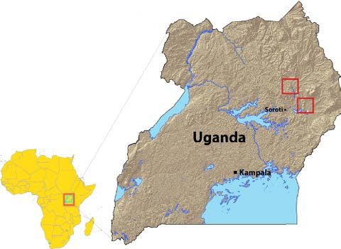
Figure 1
Map of Uganda; Kapelebyong and
the gauge are marked by the top red
square, and Magoro and Ngariam are
located at the bottom red square.
4Action-based flood forecasting for triggering humanitarian action
appeared in Hydrology and Earth System Sciences | 5 September 2016| |
https://www.hydrol-earth-syst-sci.net/20/3549/2016/
2. Context
2.1 Region
The Uganda Red Cross Society, with support from the German Red Cross and the Red
Cross Red Crescent Climate Centre, is implementing a forecast-based financing pilot in the
north-eastern part of the country. As part of this pilot, the German Red Cross established
a novel Preparedness Fund that can be disbursed to take predefined preparedness actions
when a triggering forecast is issued in this region. At the time of writing, there are more
than a dozen such forecast-based financing projects operational globally.
The Teso region of north-eastern Uganda is a swampy region, prone to river flooding
and waterlogging during the two rainy seasons centred in May and October. The Uganda
Red Cross Society project areas are in the sub-districts of Magoro and Ngariam in Katakwi
district on the Apapi River, and Kapelebyong in Amuria district on the Akokoro River (see
Fig. 1). Unfortunately, there is no calibrated hydrological model available for these rivers.
Both rivers drain into Lake Bisina and eventually into the Nile.
The Uganda Red Cross Society selected this pilot region based on vulnerability to
floods. As regional conflict subsided in the 1990s and 2000s, this region was gradually
resettled, and nowadays many of the current residents practice farming and raise
livestock. Since that time, several flood events have impacted the area. The floods
typically cause impassable roads, loss of crops, outbreaks of waterborne diseases, and
collapse of houses and latrines (OSSO and LA RED, 2009).
Whenever a flood is reported, the Uganda Red Cross Society has a mandate to assess
the situation and respond. In past events such as the 2007 floods, they have provided
postdisaster shelter and relief items to the affected population (Jongman et al., 2015). Both
the flood losses and the disaster response expenses could be reduced if anticipatory
measures were deployed before the flood, after unusual conditions are forecast. Based on
the methodology articulated in this paper, forecast-based financing thresholds were
operationalized in mid-2015, consisting of standard operating procedures for forecast-
based action. In November 2015, a “triggering” forecast successfully initiated action (Red
Cross Red Crescent Climate Centre, 2015). This was the first time the local branch had
used a preparedness fund to take action before flood disaster reports were issued, and
while the impacts are still being analysed, the region reported flooding after the trigger
had been reached in one of the project areas.
2.2 Actions
To set up the forecast-based financing system to initiate early action, the Uganda Red
Cross Society project team identified preparedness actions that could be taken prior to a
flood event, through consultations with people living in the affected areas as well as
internal discussions and two facilitated workshops. Participants in the workshops
included disaster managers, volunteers, the Uganda Meteorological Authority and district
officials (Jongman et al., 2015). In each of the workshops, the disaster managers from the
Uganda Red Cross Society discussed the quantitative and qualitative costs and losses
associated with three scenarios: (1) taking successful action, (2) failing to act before a
flood, and (3) acting “in vain”. For each action, they first answered questions individually
before discussing collectively. Lastly, disaster managers estimated their willingness to “act
in vain”, expressed as a number of times out of 10.
Ultimately, the team selected a set of actions that were seen as both impactful and
implementable by the Uganda Red Cross Society. One action (evacuation) was eliminated
because about one-quarter of the respondents indicated that they would not be willing to
act in vain at all. The political and reputational costs of evacuating in vain are
considerable. The remaining selected actions are specified in Table 1. For these three
actions, the disaster managers came to a consensus that they would be willing to act in
5Action-based flood forecasting for triggering humanitarian action
appeared in Hydrology and Earth System Sciences | 5 September 2016| |
https://www.hydrol-earth-syst-sci.net/20/3549/2016/
vain approximately 50% of the time. Here, we use this as the “tolerable” amount of acting
in vain to establish the forecast-based financing system for this set of actions. Later in the
paper, we estimate the probability that the GloFAS forecast triggers are an “intolerable”
system, or one that causes disaster managers to act “in vain” more than 50% of the time.
For each action, the Uganda Red Cross Society specified how many days would be
needed to carry out the action, which should correspond to the forecast lead time
(Jongman, 2015). The specified lead times are contingent on the assumption that several of
the procurement and volunteer training steps would be carried out at the beginning of the
flood season, to enable quick action based on a short-term forecast.
Secondly, they identified the “action lifetime”: the period of time after the action is
completed during which it offers preparedness or protection from the extreme event.
Traditional flood forecast evaluations are specific to the time period forecasted, evaluating
whether a single forecasted day did indeed flood. Humanitarians would count this as a
“hit” and, unlike forecasters, they would also consider it to be a “hit” if the flood instead
occurred 5 days after the forecasted date and the action lifetime was 30 days. In such a
case, the action would still be effective in reducing impacts, even though the flood
occurred slightly later than the forecasted date.
Therefore, the methodology detailed in this paper avoids re-triggering an action if the
“action lifetime” of a previous action is still ongoing. For example, after digging drainage,
the team would not re-trigger digging of trenches until the first set of trenches could be
assumed to have degraded, likely about 90 days after digging. While the end of the
“lifetime” is not a strict transition from useful to non-useful, it is an estimation of the date
at which the Uganda Red Cross Society would find it acceptable to re-trigger the action in
the region. We posit this constraint throughout the paper; an action cannot be re-triggered
until the action lifetime of the preceding action is over.
The selected actions are listed in Table 1 (note that this is a subset of all actions that
were originally considered).
2.3 Forecasts
This paper proposes a method for identifying a forecast that could trigger one or more of
these actions before a potential flood, given the constraint of acting in vain less than 50%
of the time. As mentioned earlier, there is no locally available flood forecasting system,
and there is only one river gauge with recorded discharge in the pilot area.
Unfortunately, the large upstream catchment area dictates that rainfall in a specific
village is not a useful proxy for flood risk in that village. Given these constraints, we
choose to examine whether river discharge forecasts from the Global Flood Awareness
System (GloFAS) can be used to trigger action in this data-scarce location in ways that
are compatible with stakeholder priorities. Probabilistic hydrometeorological forecasts
have been evaluated globally, and have been shown to have limited skill (e.g. Alfieri et al.,
2012; Li et al., 2008; Wu et al., 2014).
GloFAS is an operational global ensemble flood forecasting system developed in
partnership between ECMWF, the European Commission Joint Research Centre, and the
University of Reading (Alfieri et al., 2013). Currently in a preoperational development
phase, calibration of the model with river flow observations, where available, is being
carried out in a research mode. The model version used here is not calibrated for the
north-eastern Uganda catchments. GloFAS is run once a day to produce probabilistic
discharge estimates over the entire globe at a resolution of 0.1 (approximately 11 km at the
Equator). Here, we use daily historical GloFAS forecasts from 2009 to 2014, as well as gauge
data from the (only) local Akokoro gauge from 2009 to 2013, which overlap for 2014 days.
The gauge is located at approximately 1.86°N, 33.85 °E.
GloFAS is driven by the ECMWF ensemble forecasting system, with 51 ensemble
members at lead times of 0 to 45 days. The first 15 days include rainfall forecasts, and the
following days are river routing only. The probabilistic flood forecasts are available free of
charge on a password-protected website (http://www.globalfloods.eu/). GloFAS takes a
6Action-based flood forecasting for triggering humanitarian action
appeared in Hydrology and Earth System Sciences | 5 September 2016| |
https://www.hydrol-earth-syst-sci.net/20/3549/2016/
“model climatology” approach, aiming to forecast extremes or anomalies in river flow
relative to historical “climatology” runs of the model (Hirpa et al., 2016). This approach
addresses the problems of the lack of representation of local-scale channel geometry and
bias in the precipitation forcing. However, one of the major challenges is to link the model
climatology to the real world, focusing on the percentiles rather than absolute values of
the forecast.
3 Methods
To define a forecast probability that could be used to trigger early action in the Uganda
forecast-based financing system, we (1) estimate the quantity of discharge that represents
a flood and (2) identify the forecast probability that will make it worthwhile to take
preparedness actions (less than 50% chance of acting in vain).
3.1 What hydrometeorological “danger level” represents a flood?
While the relationship between water levels and flood risk will vary over time due to
trends in vulnerability and exposure, here we define a percentile of discharge that is
qualitatively associated with reported flood events of the past few years, when avoidable
losses were observed. For flood reports, we use two sources of information: humanitarian
records and media reports.
With regards to the humanitarian records, we combine records from the Desinventar
database (UNISDR, 2011) with an internal record system of disasters that are reported to
the Uganda Red Cross Society. Between the two humanitarian data sets, they contain
eight distinct records of floods in the Magoro area from 2009 to mid-2014; these floods
occurred in 2010, 2011, and 2012.
For the media analysis, we analysed two national Ugandan newspaper repositories:
Daily Monitor and New Vision. We filtered each repository with 40 flood-related
keywords.1.
Table 1 Actions selected for a forecast-based financing system.
See Jongman et al. (2015) for more information on the actions and their associated costs. Note that the implementation time of an
action should equal the lead time of the forecast selected to trigger that action.
Time required to complete the How long the action will benefit the community
Action action (implementation time) after it is completed (action lifetime)
Water storage and purification: distribute jerry cans, soap, 4 days to complete 30 days after completion
and a 30-day supply of chlorine tablets to vulnerable
households.
Water drainage: dig trenches around homes to divert water. 4 days to complete 90 days after completion
Food storage: bag vulnerable items and move to storage 7 days to complete 30 days after completion
facilities on high ground.
From Daily Monitor we downloaded a total of 2974 news articles between 2004 and
2015. From New Vision we downloaded 752 news articles between 2001 and 2015.
Unfortunately the database for New Vision could not be fully accessed, since the news
repository allows access to only the top 200 newspapers per query, without the possibility
for an advanced search.
1 The keywords are flood, floods, flooding, inundation, inundations, landslide, dam break, dam burst, dam bursting,
dam breached, dam fail, dam failed, dam failing, dam failure, dam broken, dam collapse, dyke break, dyke burst,
dyke bursting, dyke breached, dyke fail, dyke failed, dyke failing, dyke failure, dyke broken, dyke collapse,
embankment break, embankment burst, embankment bursting, embankment breached, embankment fail,
embankment failed, embankment failing, embankment failure, embankment broken, embankment collapse,
submerged, overflowed, breach, water-logging.
7Action-based flood forecasting for triggering humanitarian action
appeared in Hydrology and Earth System Sciences | 5 September 2016| |
https://www.hydrol-earth-syst-sci.net/20/3549/2016/
Within the database total of 3726 news articles, we clustered the sentences in the
articles using a K-means clustering algorithm (Hürriyetoglu, unpublished; Kaufman and
Rousseeuw, 1990). Next we annotated the clusters using four classes: 1. Current flood
event; 2. Past event or flood warning; 3. Mixed; and 4. Unrelated. After annotation we
found that a total of 1721 news articles held relevant flood information (annotated as class
1 or 2). To obtain geographical information, we filtered the sentences for any “marker”
terms that are often used when the writer specifies a location, and within this subset we
looked for mentions of district and sub-county names.2 As a result, for the district of
interest (Katakwi) we found a total of 27 news articles with flood sentences AND
geographical reference. Applying the same approach to all districts in Uganda we found a
total of 1173 of such articles (except in this case we did not only use the sentences
containing geographically related keywords).
With these results from the algorithm, we validated the result manually for the
districts of our interest by reading the articles. For 85% of the events we had found an
actual flood event described in the text, meaning that the flood event was
automatically detected for the correct month/year in the correct location(s).
Conversely, 15%were false positives, meaning the text was describing a non-flood
event. The result of this data mining of the news repositories is a historical flood
overview with dates of flood occurrences in Katakwi district (it can be accessed here:
https://www.floodtags.com/ historic-floodmap-uganda). There are 13 newspaper
reports of flooding within our time series.
While this accounts for many events, not all disasters are included in these databases,
and some of those included may have had less impact than others. The effect of this
underrepresentation is an overestimation of acting in vain, which renders our trigger
selection conservative. In addition, impact is not perfectly correlated with flood
magnitude, given that vulnerability can change over time. Therefore, we only attempt a
qualitative comparison of discharge and reported flood events, which adds additional
(unquantified) uncertainty to the calculation of false alarms in the following section.
As we do not have a gauge for the Apapai River, where Magoro and Ngariam sub-
counties are located, we use the daily ensemble median of GloFAS forecasts at a lead time
of 0 as a proxy for actual discharge and compare this with the above data sets of reported
disasters in those two locations. We qualitatively select a threshold percentile of discharge
to be considered the “danger level” or “flood” for this region, rather than an absolute value.
The exact percentile is a subjective selection to approximate the base rate of reported
floods, ideally including the maximum number of exceedances that were indeed followed
by a reported flood event.
3.2 What forecast probability should trigger action?
Using this selected “danger level” percentile as a proxy for the amount of discharge that
causes a flood, we calculate what probability of exceeding the danger level should trigger
action. Here, we calculate probabilities using the forecast ensemble, evaluating them
against the gauge discharge.
The forecast verification score of interest to humanitarian actors is the false alarm
ratio (FAR) (Hogan and Mason, 2012; Lopez et al., unpublished), defined as the number of
forecast-based actions that were not followed by a flood, divided by the total number of
actions that were triggered by the system. It thus represents the proportion of actions that
are taken “in vain”. Here, we take into account the action lifetime, so any action that was
followed by a flood during its lifetime is considered a “hit”, and only actions that have no
flooding at any point during their lifetime are “in vain”. Similarly, a second action is never
triggered during the lifetime of another action.
2 They are affected NOT not, hit NOT not, situation AND bad, situation AND worse, situation AND worst, cut off,
displaced, destroyed, submerged, collapsed
8Action-based flood forecasting for triggering humanitarian action
appeared in Hydrology and Earth System Sciences | 5 September 2016| |
https://www.hydrol-earth-syst-sci.net/20/3549/2016/
To estimate the FAR, we compare the nearest grid box of the GloFAS forecast with
the river gauge on the Akokoro River, for which we have an overlapping time period of
daily data from 10 January 2009 to 31 December 2014. The correlation of these two data
sets is 0.52. In the context of a forecast-based financing system, the Red Cross or other
humanitarian actors will take action when the forecast meets or exceeds a triggering
probability of flooding. The FAR is therefore calculated as follows: (1) any forecast
meeting or exceeding the trigger probability is considered an action; (2) any action
followed by a flood within the action lifetime of 30 days is counted as a “hit”, otherwise
an action “in vain”.
Our first goal is to estimate whether a forecast indicating a 50% chance of flooding
would indeed correspond to a 50% chance of flooding in the real world. We plot reliability
diagrams (Broecker, 2012) for the forecast at 4- and 7-day lead times at the gauge location,
as well as the Glo- FAS forecasts in the two non-gauge project locations, comparing 4-day
lead-time forecasts with the 0-day forecasts to approximate actual discharge. However, in
such a small sample, the incidence of forecasts of rare events is low, and therefore the
confidence intervals in these reliability diagrams are very wide.
Given such a small number of years to calculate the performance of forecasts with regards
to extreme events, however, we cannot be sure that the estimate of FAR in the sample is
representative of the true value. For example, if the estimate from our sample yields a FAR
of 30 %, it is still possible that the real value is actually greater than 50 %. This means
that, in reality, the selected trigger level for our forecastbased financing system would
cause the Uganda Red Cross Society to act “in vain” more than 50% of the time, which is
not considered “tolerable”. To estimate the risk of setting up an “intolerable” system, we
calculate confidence intervals around the FAR by using bootstrap resampling. To account
for the autocorrelation of the discharge time series, we use a 60-day fixed block bootstrap
to generate 10 000 samples by resampling with replacement the time series (n = 2014) of
forecast–observation pairs. Given a trigger forecast probability, for each sample we
calculate the FAR and generate a distribution of all the sample FARs. This is repeated for
each trigger probability, and we demonstrate results for three triggers: forecast
probabilities of 30, 50, and 70 %. Based on these results, we estimate the likelihood that
taking action when one of these forecast probabilities is exceeded will lead to a FAR above
50 %, which would fail to satisfy the decision-maker requirements for action “in vain”.
Figure 2
Forecasted discharge (circles) at
Magoro sub-county, Uganda,
represented by a GloFAS forecasts
ensemble median at lead time 0.
Dates of disasters in the regions
along the Apapai River are indicated
by dark blue vertical lines, as per the
databases of the Uganda Red Cross
Society and Desinventar. Newspaper
reports of flooding in the district of
Katakwi are indicated by light blue
vertical lines. Small tick marks on the
x axis correspond to months within a
year. The horizontal dashed red line
indicates the 95th percentile of
estimated discharge; dates with
discharge above this threshold are
coloured in red.
9Action-based flood forecasting for triggering humanitarian action
appeared in Hydrology and Earth System Sciences | 5 September 2016| |
https://www.hydrol-earth-syst-sci.net/20/3549/2016/
4 Results
4.1 What hydrometeorological danger level represents a flood?
To estimate the percentile of discharge that is associated with flooding in the project
region, we plot the historical median water levels forecasted at a lead time of 0 by the
GloFAS model. Here, we focus on the Apapi River, where two project districts are located
and several disaster records exist. Because Ngariam sub-county is directly upstream of
Magoro sub-county, we plot simulated discharge at Magoro and reported flood events in
both sub-counties (Fig. 2). Comparing this with historical floods (dark blue lines), and
media reports from the district (light blue lines), we qualitatively select the 95th percentile
(horizontal red line) as a proxy for disaster.
In the 6 years of 2009–2014, this danger level would have been exceeded in 2010, 2011,
and 2012 (see Fig. 2). In April 2010, reports indicate that 12 secondary schools and 7000
people were affected by flooding in the area, followed by crop losses due to waterlogging in
May 2010. Flooding continued to be reported through to September and October of that
year, affecting several regional roads. This corresponds well to the simulated discharge for
those years.
In 2011, simulated discharge again accords well with reported flooding that affected
both people and infrastructure in the area. In 2012, waterlogging reports to the Uganda
Red Cross Society arrived in August, which is substantially after the peak modelled
discharge, and the newspaper reports are concentrated in October and November. It is
possible that the peak discharge did correspond to the model data and was not reported,
or was reported at a later time. Our threshold was not crossed in 2013 and 2014, which
accords well with the lack of reported floods in those years.
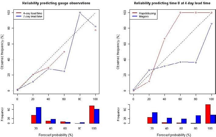
Figure 3
Reliability diagram for the gauge
location (left) and the two project
locations (right). This shows how
many times a flood occurred for each
forecast probability category. For the
gauge location, GloFAS forecasts at
two lead times on the Akokoro River
are compared with gauge discharge
(left). At the two project locations,
GloFAS 4-day lead-time forecasts are
compared with 0-day forecasts.
Seven-day forecasts are not shown
in the right panel, as results are very
similar to the 4-day plots. The
frequencies of forecast probabilities
of 0% are 1688, 1655, 1702, and
1658, for Gauge 4-day, Gauge 7-day,
Kapelebyong, and Magoro,
respectively. These are not plotted in
the frequency bar graph as they
would extend past the scale. Lastly,
due to sampling uncertainty, 95%
confidence intervals extend nearly
from 0 to 1, and are therefore not
plotted.
We begin to see other years (with no disasters) counted as “floods” if we lower the
danger level below 93 %, and if we raise it above the 99th percentile very few years exceed
the threshold. Therefore, we assume from the limited data available that discharge above
the 95th percentile is likely indicative of flood conditions in this location, and in the
following analysis, anything above the 95th percentile is defined as a “flood”. In
Kapelebyong sub-county, the other project location in this region, the only recorded
disasters are from the devastating floods of 2007, which are not available in Glo- FAS
reforecasts. Therefore, we also assume this percentile applies to Kapelebyong, as the
infrastructure and vulnerability are similar in the two areas.
10Action-based flood forecasting for triggering humanitarian action
appeared in Hydrology and Earth System Sciences | 5 September 2016| |
https://www.hydrol-earth-syst-sci.net/20/3549/2016/
4.2 What forecast probability should trigger action?
We consider forecasts of 4-day and 7-day lead times, aiming to identify a trigger that
corresponds to a FAR of 0.5 or less. If the forecast probability of exceeding the flood danger
level is 50 %, then the observed frequency of exceeding the flood threshold should be 50%
for a reliable forecast.
In Fig. 3, we plot the reliability of the forecast at both lead times when compared to
gauge discharge on the Akokoro River. In the project locations with no gauge, we also
examined the ability of GloFAS to forecast itself 4 days in advance (Fig. 3, right-hand
reliability diagram). In both cases, we are unable to establish the reliability with
confidence given the small sample size.
If we set the trigger given these limited data, how likely is it that we developed a
system that is “intolerable” to the Uganda Red Cross Society, actually leading disaster
managers to act “in vain” more than 50% of the time? Figure 4 shows the FAR from
Figure 4 10 000 resamples as a probability distribution function. This assumes that action is
Histogram of false alarm ratio
triggered when the forecast probability of flooding reaches or exceeds 30, 50, or 70 %, and
calculations from a block
bootstrapped resample of a time that there is a 30-day action lifetime.
series of 2014 days of forecast–
The bootstrapped results indicate a high chance of a “tolerable” system, especially at
observation pairs. The vertical axis
depicts probability density. Each higher forecast triggers. Only 24, 19, and 18% of all the bootstrapped samples returned an
sample is calculated for 4-day lead
“intolerable” system (grey bars) for a threshold of 30, 50, and 70 %, respectively. This is
times at different forecast trigger
values. The black bin contains the true for a sample size of 2014 days. This represents the chance that the system does not
value of FAR from the original time
pass the required specifications, and would cause humanitarian actors to act “in vain”
series, and bins exceeding a FAR of
0.5 are grey. All FAR calculations more than 50% of the time in the long run. While increasing the forecast trigger does
assume a 30-day action lifetime.
reduce this risk, the effect is not substantial given the small data set available.
11Action-based flood forecasting for triggering humanitarian action
appeared in Hydrology and Earth System Sciences | 5 September 2016| |
https://www.hydrol-earth-syst-sci.net/20/3549/2016/
5 Discussion
The calculations and estimations used here build on established forecast verification
methods, combining information on both actions and forecast skill to enable the use of
forecasts by the humanitarian community.Without incorporating information about the
action, it is unlikely that the humanitarian community would be willing or able to plan for
preparedness actions using existing seemingly arbitrary forecast verification measures.
As illustrated here, there are two major components of action-based forecasting.
Forecasters and disaster managers (1) select the appropriate danger level of a hazard that
causes avoidable losses and (2) calculate the FAR for specific trigger probabilities based on
willingness to act in vain.
These two components can be readily applied to most other forecastable natural
hazards. First, there are many possibilities for defining the “danger level” of river floods
both spatially and temporally; Stephens et al. (2015) have suggested several different
definitions of “floodiness” that could correspond to danger levels in varying river
situations. Outside of riverine flood hazards, “danger levels” of rainfall are available for
flash flood events (Bacchini and Zannoni, 2003; Yang et al., 2015). Beyond floods altogether,
heatwaves are an example of hazard where there are many epidemiological studies to
identify temperatures that are linked to increased morbidity and mortality (Hajat et al.,
2010; Knowlton et al., 2014b; WMO and WHO, 2015). The same applies to storm surge
heights, drought indices, wind speeds, etc. (MuirWood et al., 2005; Ross et al., 2009).
Although the methods for defining the “danger level” for each type of hazard can and
do differ, many do rely on reports of historical disaster events (Bacchini and Zannoni,
2003; Loughnan et al., 2010). The method of news repository data mining used here is a
scalable method to identify approximate dates of impacts. This can be enhanced by
improving the geocoding database (e.g. correcting errors in the Open- StreetMap database
for Uganda), improving the clustering methods (e.g. isolating different flood incidences
including blocked roads and improving geocoding) and negotiating access to more
newspapers (e.g. better access to the New Vision repository). Further qualitative research
on the news articles related to flooding in the region of interest can also help guide the
selection of what types of forecast-based action would be most appropriate for the region.
The second component of action-based forecasting is calculation of the FAR at the
specified danger level. Instead of static forecast verification metrics, the FAR for any
hazard forecast should be calculated according to these contextspecific parameters,
including the action lifetime. The World Meteorological Organization has issued guidance
on impactbased forecasting, which includes information on selecting threshold danger
levels that then can be forecasted for target recipients (WMO, 2015). This guidance does
not address probabilities using deterministic terminology such as “winds are expected”. It
does not include information on how to select trigger probabilities for a specific action,
and could therefore be complemented by the techniques described here.
Critical to selection of triggers based on the FAR results is the estimation of
willingness to act “in vain”. When it comes to the risk of an “intolerable” system that has
too many false alarms, donors will also need to consider the implications of such a risk for
their portfolio. In the Uganda example, disaster managers estimated that they would be
willing to act “in vain” 50% of the time. It should be noted that there is evidence that when
people are asked to express probabilities, their choice of 50% is often an expression of not
being sure as to the answer (Fischhoff and Bruine de Bruin, 1999; Tetlock and Gardner,
2015). While the 50% constraint from local stakeholders was respected in this study,
further research into decision science could improve how this answer is elicited. Such
research, in collaboration between forecasters, users, and behavioural scientists, could
identify any biases that humanitarian decision makers should actively avoid.
Almost all of the steps in this analysis contained unquantifiable uncertainties. On the
side of the forecasts, uncertainties can be reduced with longer reforecast time series for
each model update, as well as the implementation of local record-taking devices for
calibration. On the side of the actions, uncertainties are likely larger and much more
12Action-based flood forecasting for triggering humanitarian action
appeared in Hydrology and Earth System Sciences | 5 September 2016| |
https://www.hydrol-earth-syst-sci.net/20/3549/2016/
difficult to quantify. The lives and vulnerabilities of the people living in the target villages
are constantly evolving, as are the capabilities and priorities of the humanitarian sector.
While these are difficult to reduce, continual updates to danger levels and triggers as well
as simulations with all relevant actors can confirm that the critical values and
assumptions still hold.
6 Conclusion
Forecast-based financing aims to link forecasts to actions in advance of disasters. In this
applied research, we have illustrated the development of such a system in a vulnerable
context, where calibrated local forecasts do not exist to support such decision-making.
Examining the application of forecast-based financing in a data-scarce region of Uganda,
we have proposed an action-based forecasting methodology to answer two critical
questions to enable early action based on flood warnings.
1. Given limited observational data and forecast availability, how should the danger level
threshold be chosen that represents an impactful flood?
2. Given the limitations of assessing forecast skill using limited observational data, how
should the forecast probability of triggering early action be optimized to avoid
intolerable levels of false alarms?
Using this action-based forecasting methodology, we demonstrate that global flood
products can already trigger worthwhile actions, even in data-scarce locations. Assuming
that a specific extreme value of forecasted discharge is a valid proxy for a “danger level” in
an area with limited data records, the GloFAS model can be used to trigger timely
humanitarian action in advance of an extreme event. Not only is there early action that
can be justified based on the false alarm ratio of the GloFAS forecast in this area, the
probability of triggering an unacceptable level of false alarms is less than 25% in this
region. Part of the reason for such skill in the model is that the actions taken by
humanitarians have long “lifetimes”, and therefore are forgiving if the forecast is early and
the flood comes late.
It is encouraging that a global flood forecasting system has the potential to support
decisions, although this is not a replacement for better observational data or the
development of calibrated catchment-scale models. While this method can successfully
forecast many instances of extreme river flow, it is only able to trigger actions that can
in practice withstand a large number of false alarms. Indeed, better observational data
sets and catchment-scale models could enable us to estimate the hazard–damage curve
in a specific locality, modelling the precise level of discharge that causes inundation
and associated impact in specific areas. This type of modelling could allow for the
selection of more specific and targeted preparedness actions, including actions specific
to “small” floods that would no longer be useful in a major flood (e.g. storage of water,
which would not be useful if one needed to later evacuate). Similarly, forecast-based
actions could be crafted for different “types” of flooding, such as long-duration or single
high flows (Stephens et al., 2015). Data constraints are often cited as the barrier to
forecastbased action in rural areas of the world, and longer data sets over time will
indeed allow for more precise calculation of flood thresholds and the inclusion of
additional triggers for action.
Model changes are continually implemented in real-time forecasting systems, and the
experimental GloFAS model version used for this study has already been updated several
times. These dynamic changes to the forecasting system add additional uncertainty to the
implementation. In each model update, the danger level and triggers need to be
recalibrated with additional reforecasts, to assess how the danger level and FAR might
have increased or decreased in a given forecast-based financing project location. To partly
avoid this cumbersome requirement of constant reforecasts, forecasters developing an
13Action-based flood forecasting for triggering humanitarian action
appeared in Hydrology and Earth System Sciences | 5 September 2016| |
https://www.hydrol-earth-syst-sci.net/20/3549/2016/
operational product can consider forecast corrections to ensure that the climatology of the
model does not change with model updates. This will ensure that the danger level stays
constant even if the FAR does change.
However, “the perfect should not be the enemy of the good”. With relatively limited
local and global data available, effective humanitarian action can be triggered in
advance of potential flooding. Humanitarian actors have a mandate to serve vulnerable
people, and cannot wait to engage in flood preparedness measures until sufficient local
data are collected over the years to establish “conventional” predictive models, especially
when global models may give signals of likely extreme conditions in the foreseeable
future. Moreover, the forecast-based financing system based on this method of analysis
did indeed trigger action for the first time in Uganda in November 2015, when water
purification tablets, soap, shovels, and storage bags were distributed to the at-risk
population. Evaluation of the entire system, including the effectiveness and timeliness of
these actions, is ongoing.
This simple methodology can easily allow for improvement over time, adjusting
parameters such as danger levels or probability thresholds as experience reveals to
stakeholders’ the desirability of redefining parameters based on objective calculations or
valid subjective preferences. Additionally, this approach can be extended to other
locations and potentially scaled up to regional or national mechanisms that systematically
trigger early action to address flood risks among vulnerable people around the world. In
particular, the innovation of forecast-based financing can encourage the collaboration
between development and humanitarian actors to deliberate relevant forecast-based
actions; these can both promote and protect long-term development efforts.
In the long term, there are opportunities to reduce the lead time needed for
preparedness measures, to offer more choices of actions that can be taken in the window
of time between a forecast and the potential disaster. Such innovations include everything
from unmanned aerial vehicles to rapidly delivering health materials to rural locations
(Bamburry, 2015) to blockchain and smart contract technologies allowing instant transfers
of programmable money (Currion, 2015; Forte et al., 2015).
Operationalizing forecast-based financing systems is within reach. First, more
flexible humanitarian financing is needed that allows and incentivizes early action
despite the risk of acting in vain; this is currently being considered by various
humanitarian and development donors. Successful implementation of such funding
requires improved incentives towards early action and enabling an iterative learning
process toward more effective links between early warning and early action. To achieve
this, further investments are needed at the practitioner interface between scientific and
humanitarian organizations. Humanitarian actors need to identify risk reduction and
preparedness actions that can be taken before a potential flood, and agree on their level
of willingness to act “in vain” for each action. By the same token, natural scientists (e.g.
forecasters and flood modellers) need to continue deepening their engagement with
humanitarians and other stakeholders who can help turn scientific knowledge and skills
into societal benefits. A closer collaboration between these groups and the international
development community should ensure the relevance and success of forecast-based
actions. There is also a need for decision science expertise to advance the design of
processes that can help to better engage stakeholders in understanding and defining
thresholds. Further collaboration among researchers and practitioners on the
development of such systems can unlock the potential to greatly reduce the
consequences of recurrent disasters around the world.
14Action-based flood forecasting for triggering humanitarian action
appeared in Hydrology and Earth System Sciences | 5 September 2016| |
https://www.hydrol-earth-syst-sci.net/20/3549/2016/
Acknowledgements
The authors of this paper would like to extend their gratitude to the donors who have
made the forecast-based financing pilots possible. The pilot project in north-eastern
Uganda is funded by the German Federal Ministry for Economic Cooperation and
Development (BMZ). In addition, the German Federal Foreign Office has developed an
action plan for humanitarian adaptation to climate change (Rüth, 2015), and has invested
in forecast-based financing in several other countries in Africa and around the world.
We would also like to thank many who have contributed to this approach, including
Leo Mwebembezi of the Uganda Hydrological Department, the entire Uganda Red Cross
Society implementing team, the GloFAS team, and participants in the Forecast-based
Financing Dialogue Platform hosted biannually by IFRC in Geneva. E. Stephens’ time was
funded by Leverhulme Early Career fellowship ECF-2013-492.
Edited by: Giuliano Di Baldassarre
Reviewed by: M. Begovic and one anonymous referee
15Action-based flood forecasting for triggering humanitarian action
appeared in Hydrology and Earth System Sciences | 5 September 2016| |
https://www.hydrol-earth-syst-sci.net/20/3549/2016/
Références different approaches to identifying dangerously hot
days., Am. J. Public Health, 100, 1137–1144, doi:10.2105/
Alfieri, L., Salamon, P., Pappenberger, F., Wetterhall, F.,
AJPH.2009.169748, 2010.
and Thielen, J.: Operational early warning systems for
Harriman, L.: Cyclone Phailin in India: Early warning and
water- related hazards in Europe, Environ. Sci. Policy, 21,
timely actions saved lives, Environ. Dev., 9, 93–100,
35–49, doi:10.1016/j.envsci.2012.01.008, 2012.
doi:10.1016/j.envdev.2013.12.001, 2014.
Alfieri, L., Burek, P., Dutra, E., Krzeminski, B., Muraro, D.,
Hewitt, C., Mason, S., and Walland, D.: The Global
Thie- len, J., and Pappenberger, F.: GloFAS – global
Frame- work for Climate Services, Nat. Clim. Chang., 2,
ensemble stream- flow forecasting and flood early
831–832, doi:10.1038/nclimate1745, 2012.
warning, Hydrol. Earth Syst. Sci., 17, 1161–1175,
Hirpa, F. A., Salamon, P., Alfieri, L., Thielen-del Pozo, J.,
doi:10.5194/hess-17-1161-2013, 2013.
Zsoter, E., and Pappenberger, F.: The Effect of
Bacchini, M. and Zannoni, A.: Relations between rainfall
Reference Climatology on Global Flood Forecasting, J.
and triggering of debris-flow: case study of Cancia
Hydrometeorol., 1131–1145, doi:10.1175/
(Dolomites, Northeastern Italy), Nat. Hazards Earth
JHM-D-15-0044.1, 2016.
Syst. Sci., 3, 71–79, doi:10.5194/nhess-3-71-2003, 2003.
Historic Flood Events Uganda Floodtags: https://www.
Bamburry, D.: Drones: Designed for Product Delivery, Des.
floodtags.com/historic-floodmap-uganda/, 2016.
Manag. Rev., 26, 40–48, doi:10.1111/drev.10313, 2015.
Hogan, R. J. and Mason, I. B.: 3 Deterministic forecasts of
Bozkurt, M. and Duran, S.: Effects of natural disaster
binary events, edited by: Jolliffe, I. T. and Stephenson,
trends: a case study for expanding the pre-positioning
D. B., available at: https://eprint.iacr.org/2015/1164.pdf
network of CARE International., Int. J. Environ. Res.
(last access: 31 August 2016), 2012.
Health, 9, 2863–2874, doi:10.3390/ijerph9082863, 2012.
Houghton-Carr, H. and Fry, M.: The decline of
Bozorgi-Amiri, A., Jabalameli, M. S., and Mirzapour
hydrological data collection for development of
Al-e-Hashem, S. M. J.: A multi-objective robust
integrated water resource manage- ment tools in
stochastic programming model for disaster relief
Southern Africa, Clim. Var. Chang., 308 p. 51, 2006.
logistics under uncertainty, O. R. Spectr., 35, 905–933,
Hürriyetoglu, A.: [A Tool]: Finding and Labeling Relevant
doi:10.1007/s00291-011-0268-x, 2011.
Information in Tweet Collections, unpublished.
Broecker, J.: Probability forecasts, edited by: Jolliffe, I. T.
IFRC: World Disasters Report 2009: Focus on early warning,
and Stephenson, D. B., John Wiley & Sons, Ltd,
early action, available at: http://www.ifrc.org/Global/
Chichester, UK, doi:10.1002/9781119960003.ch7,
WDR2009-full.pdf (last access: 31 August 2016) 2009.
119–139, 2012.
IPCC: Managing the Risks of Extreme Events and Disasters to
Brown, M. E., Funk, C. C., Galu, G., and Choularton, R.:
Advance Climate Change Adaptation, edited by: Field, C.
Earlier Famine Warning Possible Using Remote
B., Barros, V., Stocker, T. F., and Dahe, Q., Cambridge
Sensing and Models, Eos, Trans. Am. Geophys. Union, 88,
University Press, Cambridge, 2012.
381–396, 2007.
Jongman, B., Coughlan de Perez, E., Nguyen, T.-B., and
Coughlan de Perez, E., van den Hurk, B., van Aalst, M. K.,
Mawanda, S.: Towards forecast-based humanitarian action
Jong- man, B., Klose, T., and Suarez, P.: Forecast-based
for floods in Uganda, VU University Amsterdam,
financing: an approach for catalyzing humanitarian
137–158, 2015.
action based on extreme weather and climate
Kaufman, L. and Rousseeuw, P. J.: Finding Groups in Data;
forecasts, Nat. Hazards Earth Syst. Sci., 15, 895–904,
An Introduction to Cluster Analysis, John Wiley & Sons,
doi:10.5194/nhess-15-895-2015, 2015.
Ltd., Hoboken, NJ, 1990.
Currion, P.: Leveraging blockchain tech to improve financial
Knowlton, K., Kulkarni, S. P., Azhar, G. S., Mavalankar, D.,
mechanisms in the aid sector, available at: http://www.
Jaiswal, A., Connolly, M., Nori-Sarma, A., Rajiva, A.,
start-network.org/news/, 2015.
Dutta, P., Deol, B., Sanchez, L., Khosla, R., Webster, P. J.,
Dale, M., Wicks, J., Mylne, K., Pappenberger, F., Laeger, S.,
Toma, V. E., Sheffield, P., and Hess, J. J.: Development
and Taylor, S.: Probabilistic flood forecasting and
and implementation of South Asia’s first heat-health
decision-making: an innovative risk-based approach,
action plan in Ahmedabad (Gujarat, India), Int. J.
Nat. Hazards, 70, 159–172, doi:10.1007/s11069-012-
Environ. Res. Health, 11, 3473–3492, doi:10.3390/
0483-z, 2012.
ijerph110403473, 2014a.
Ebi, K. L., Teisberg, T. J., Kalkstein, L. S., Robinson, L., and
Knowlton, K., Kulkarni, S. P., Azhar, G. S., Mavalankar, D.,
Wei- her, R. F.: Heat Watch/Warning Systems Save
Jaiswal, A., Connolly, M., Nori-Sarma, A., Rajiva, A.,
Lives: Estimated Costs and Benefits for Philadelphia
Dutta, P., Deol, B., Sanchez, L., Khosla, R., Webster, P. J.,
1995–98, B. Am. Meteor. Soc., 85, 1067–1073, doi:10.1175/
Toma, V. E., Sheffield, P., and Hess, J. J.: Development
BAMS-85-8-1067, 2004.
and implementation of South Asia’s first heat-health
Fischhoff, B. and Bruine de Bruin, W.: Fifty-Fifty 50 %?, J.
action plan in Ahmedabad (Gu- jarat, India), Int. J.
Behav. Decis. Mak., 12, 149–163, 1999.
Environ. Res. Public Health, 11, 3473–3492, doi:10.3390/
Forte, P., Romano, D., and Schmid, G.: Beyond Bitcoin – Part
ijerph110403473, 2014b.
I?: A critical look at blockchain-based systems, 1–34,
Krzysztofowicz, R.: The case for probabilistic forecasting
https://eprint. iacr.org/2015/1164.pdf (last access: 31
in hydrology, J. Hydrol., 249, 2–9, doi:10.1016/
August 2016), 2015.
S0022- 1694(01)00420-6, 2001.
Fouillet, A., Rey, G., Wagner, V., Laaidi, K., Empereur-
Li, L., Hong, Y., Wang, J., Adler, R. F., Policelli, F. S., Habib,
Bissonnet, P., Le Tertre, A., Frayssinet, P., Bessemoulin,
S., Irwn, D., Korme, T., and Okello, L.: Evaluation of the
P., Laurent, F., De Crouy-Chanel, P., Jougla, E., and
real- time TRMM-based multi-satellite precipitation
Hémon, D.: Has the impact of heat waves on mortality
analysis for an operational flood prediction system in
changed in France since the European heat wave of
Nzoia Basin, Lake Victo- ria, Africa, Nat. Hazards, 50,
summer 2003? A study of the 2006 heat wave., Int. J.
109–123, doi:10.1007/s11069-008- 9324-5, 2008.
Epidemiol., 37, 309–317, doi:10.1093/ije/dym253, 2008.
Lodree, E. J.: Pre-storm emergency supplies inventory
Galindo, G. and Batta, R.: Socio-Economic Planning
plan- ning, J. Humanit. Logist. Supply Chain Manag., 1,
Sciences Prepositioning of supplies in preparation for
50–77, doi:10.1108/20426741111122411, 2011.
a hurricane under potential destruction of
Lopez, A., Coughlan de Perez, E., Suarez, P., van den Hurk,
prepositioned supplies, Socioecon. Plan. Sci., 1–18, 2012.
B., and van Aalst, M.: Bridging forecast verification and
Alfieri, L., Burek, P., Dutra, E., Krzeminski, B., Muraro, D.,
humanitar- ian decisions: a valuation approach for
Thie- len, J., and Pappenberger, F.: Global Flood
setting up action-oriented early warning systems,
Awareness System River Discharge, http://www.
Weather Clim. Extrem., unpublished.
globalfloods.eu/, 2016.
Loughnan, M. E., Nicholls, N., and Tapper, N. J.: When the
Hajat, S., Sheridan, S. C., Allen, M. J., Pascal, M., Laaidi,
heat is on: Threshold temperatures for AMI
K., Yagouti, A., Bickis, U., Tobias, A., Bourque, D.,
admissions to hospital in Melbourne Australia, Appl.
Armstrong, B. G., and Kosatsky, T.: Heat-health warning
Geogr., 30, 63–69, doi:10.1016/j.apgeog.2009.08.003,
systems: a comparison of the predictive capacity of
2010.
16You can also read