ADMINISTERING YOUR ORACLE GEODATABASE - AMIT KESARWANI AND JIM MCABEE
←
→
Page content transcription
If your browser does not render page correctly, please read the page content below
Administering your Oracle Geodatabase
                    Amit Kesarwani and Jim McAbee
                    akesarwani@esri.com
                    jmcabee@esri.com

Esri UC 2014 | Technical Workshop |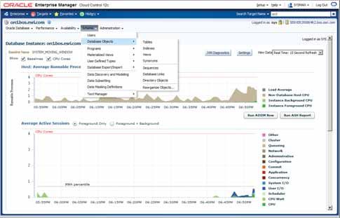
Agenda

                                      Requirements and Configuration

                                       Administration and Connections

                                            Backup and Upgrade

                                      Performance and Advanced Topics

Esri UC 2014 | Technical Workshop |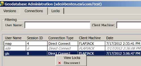
A few questions…

                      •   How many were at last years User Conference and attended this session?
                      •   How many using 10g, 11g, 12c?
                      •   How many installing arcsde and using application server – port 5151?
                      •   Who are you? DBA’s, GIS Manager’s
                      •   Experience – brand new?

Esri UC 2014 | Technical Workshop | Type Presentation Title Here
Some of Top Discussion Topics and Directions
              •   Performance
                    -   Analyze if lots of transactional editing workflows
                           -   Watch certain tables and their growth during the day – state_lineages, etc…

              •   Upgrades and Migrations
                    -   Clone vs. export/import
                           -   Check Geometry Storage type and consider migrating to default ST_Geometry spatial type.
                               Test first.
                    -   Direct Connect
              •   Deprecation of ArcSDE app server and command line tools @ 10.2.2
                    -   SDE installs (app server, command line tools) ending at 10.2.2, not present in 10.3
                    -   Direct Connect will be used 10.3 forward, SDE libraries still present
              •   Advanced Configurations and Topics
                    -   Exadata
                    -   Oracle RAC and Dataguard

Esri UC 2014 | Technical Workshop | Type Presentation Title Here
Agenda

                                      Requirements and Configuration

                                           Supported Versions

                                         Setup and Configuration

                                              Spatial Types

Esri UC 2014 | Technical Workshop |
Requirements @ 10.2.x : Oracle Versions and Supported OS
         tested and certified: verify at support.esri.com

         •   64-bit DBMS and OS only (10.1 and newer)
         •   Support begins at 10.2.1 for
               -   Oracle 12c and Multitenant – GDB can be in pluggable database not container
               -   Windows Server 2012 and Sun Solaris 11
         •   Windows Server 2003 and 2003R2 no longer supported at 10.2.2

                                             12.1.0.1
                                                                                      10.2.2, 10.2.1
                                             11.2.0.3       10.2.1                    10.2.2, 10.2.1
                                             11.2.0.1       10.2                      10.2.0
                                             11.1.0.7
                                                                                      10.2.0
                                             10.2.0.3
                                                                                      10.2.2, 10.2.1, 10.2.0

Esri UC 2014 | Technical Workshop |
Oracle 12c Multitenant
                 Pluggable databases

             •   Geodatabase can be in pluggable database not container
             •   Can provide
                   -   Rapid provisioning and cloning
                   -   Staging for patching and upgrades
                   -   Consolidation and unified management
             •   Does require additional licensing if
                 Container Database (CDB) contains more than two Pluggable Databases (PDB)
             •   Up to 252 PDB’s in a single CDB

             •   e.g. create pluggable database pdbgdb_clone from pdbgdb;

Esri UC 2014 | Technical Workshop | Type Presentation Title Here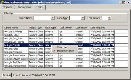
Setting up Oracle: Initialization Parameters
        •   Memory Parameters
              •   Adjust as little as possible, let Oracle manage
              •   SGA_TARGET – Automatic Shared Memory Management (ASMM)
                     •   multiple instances on same server – monitor
              •   PGA_AGGREGATE_TARGET, DB_CACHE_SIZE, SHARED_POOL,
                  LOG_BUFFER
        •   Optimizer Parameters
              •   OPTIMIZER_MODE – default “ALL ROWS”
        •   Other Parameters
              •   SESSIONS, PROCESSES and
                  GDB Connections – make sure they match
              •   UNDO_POOL enough for compress
        •   Cursor Configuration
              -   OPEN_CURSORS = 2000
              -   Tech Article #27024

Esri UC 2014 | Technical Workshop |
Setting up Oracle: Packages

                 •   Grant Execute to Public on
                      - DBMS_PIPE
                      - DBMS_LOCK
                      - DBMS_LOB
                      - DBMS_UTILITY
                      - DBMS_SQL         Default
                      - UTL_RAW

                 •   Grant Execute to SDE on
                      - DBMS_CRYPTO

                 •   After GDB creation or upgrade, privileges can be restricted

Esri UC 2014 | Technical Workshop |
Further Guidance Notes
• SGA must not swap
- enough physical memory for all instances
• Avoid excessive paging
- monitor
• Allocate enough virtual memory/paging file
- Oracle recommends swap space be at least 3 to 4 times
the size of your physical RAM.
• Use explicit quotas on tablespaces to avoid using up
available storage.
• sessions, processes and connections
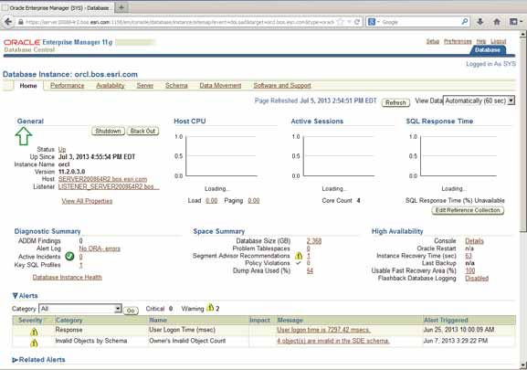
Esri UC 2014 | Technical Workshop |Checking Oracle Initialization Parameters
Enterprise Manager or SQL
Esri UC 2014 | Technical Workshop |Setup and Configuration:
Creating or Enabling via ArcGIS Desktop
Geodatabase
Schema Schema
Schema SDE
Esri UC 2014
014 | Technical Workshop |Geodatabase and Administrative Schema
ArcGIS Technology (Desktop, Server)
• Manage data through ArcGIS
- Load, edit, delete, etc..
• Manage through tool
that loads data. Geodatabase Administrative Behaviors
Schema Complex Features
Versioning
Distributed Data
Archiving
Database Spatial Type
Feature Cl
Class Transactions
(Data) Authorization/Security
Data Management
Backup
Esri UC 2014 | Technical Workshop |Controlling Storage
• Configuration keyword and parameters storage type, location, etc…
• adjust for backup requirements, activity, size of segment (table, index)
• To create a keyword:
- Export DBTUNE table to a file, edit it and import back
- sdedbtune –o export/import or alter
• VARCHAR vs. NVARCHAR
SDE.SDE_DBTUNE
• UNICODE_STRING table for storing keywords
and associated parameters
Esri UC 2014 | Technical Workshop |Geodatabase Configuration: Connections
sde.server_config table
• Geodatabase connections
• Oracle sessions
and processes
Esri UC 2014 | Technical Workshop |Geodatabase Architecture: Multiple Geodatabases
Multiple Geodatabase Configuration
• Multiple Geodatabases in Oracle
- Multiple instances on same server
- Multiple instances on different servers
- Project/Schema Geodatabase
• Reasons for multiple geodatabases
- Editing and publishing (web)
- Production and Staging
- Different application needs
- Separate version management
Production
Publishing
Esri UC 2014 | Technical Workshop |Geometry Storage
Spatial Types and Functions
• Creation of Features through SQL
• Analysis through SQL
Esri UC 2014 | Technicall Workshop
W or
orkks
ksho
ksh
hop |
hopGeometry Storage
Default Storage Type – ST_GEOMETRY
Other User Defined Spatial Types
• ST_Geometry – ESRI Spatial Type PostGIS Geometry
SDO_Geometry (Oracle)
• User Defined Type (UDT) used to store geographic features SDO_GeoRaster (Oracle)
Microsoft SQL Server Geometry
• Allows access to spatial data through SQL functions Microsoft SQL Server Geography
• Efficiency - Automatic geometry validation
• Conforms to ISO and OGC standards
• Available since ArcSDE 9.2, became default at 9.3
Esri UC 2014 | Technical Workshop |Spatial Type Functionality and Geodatabase Behavior
• External library (dll, so), Extproc set up for
- Executing SQL commands on a ST_GEOMETRY column
- For using ST_GEOMETRY operators
- Definition and label queries inside ArcMap
• Geodatabase behavior not supported through SQL
Geodatabase Administrative Behaviors
Schema Complex Features
Long Transactions
s ArcGIS
Archiving
Cross-RDBMS
Database Spatial Types
• ST_Geometry
SQL
• SDO_Geometry
Esri UC 2014 | Technical Workshop |ST_Geometry spatial type configuration
• st_shapelib library
• extproc.ora (11g) or listener.ora/tnsnames.ora configuration
Esri UC 2014 | Technical Workshop |Configure External Library – st_shapelib
• 11g use extproc.ora located in ORACLE_HOME\hs\admin directory
- EXTPROC_DLLS=ONLY:C:\\mylibraries\\st_shapelib.dll (Windows)
- EXTPROC_DLLS=ONLY:/user/esrilibs/libst_shapelib.so (Unix)
• 10g – Listener.ora and Tnsnames.ora
SID_LIST_LISTENER =
(SID_LIST =
(SID_DESC =
(SID_NAME = PLSExtProc)
(ORACLE_HOME = /servit/oracle/product/10.2.0/db_1)
(PROGRAM = extproc)
(ENVS="EXTPROC_DLLS=/servit/ArcSDE/sdeexe/lib/libst_shapelib.so")
)
Esri UC 2014 | Technical Workshop |Demo: Configuring
ST_Geometry for SQL Access
Amit Kesarwani
Esri
E sri UC
UC 2
2014
014
14 | T
Technical
ec cal
echnic al Workshop
W orksho
op |SDO_Geometry: native Oracle spatial type
• Locator or Spatial
• Validation is not the same between ArcGIS and SDO_Geometry
• Spatial reference metadata synchronization between SDE and
MDSYS administrative schemas
• SDO_ETYPE 0 data
• All data in column must be same coordinate system
• LRS implementations differ
• Modifications of complex features only through ArcGIS
• Test any custom programming carefully
Esri UC 2014 | Technical Workshop |SDO_Geometry prerequisites
• be owned by the user registering the table.
• have a single SDO_GEOMETRY column.
• have no other columns of a user-defined type.
• have a valid entry in the view USER_SDO_GEOM_METADATA.
• have a single type of geometry (points, lines, or polygons), can be
multipart.
• have an integer, unique, not-NULL column suitable as a registered row
ID column.
• should have a spatial index.
• should pass Oracle's geometry validation tests.
• All spatial records must have not-NULL valid number values in the
SDO_ORDINATES array.
Esri UC 2014 | Technical Workshop | Type Presentation Name HereAgenda
Requirements and Configuration
Administration and Connections
Backup and Upgrade
Performance and Advanced Topics
Esri UC 2014 | Technical Workshop | Administering your Oracle GeodatabaseAgenda
Requirements
Administrationand
andConfiguration
Connections
Administration and Connections
Administration Tools
Connections
User Permissions
Client Compatibility
Esri UC 2014 | Technical Workshop | Administering your Oracle GeodatabaseAdministration Tools
• Oracle and ArcGIS
• ArcSDE Command Line Tools
- Going away at 10.3, replaced
with new geoprocessing (GP)
tools
• ArcGIS Desktop and GP
- Python and Automation
Esri UC 2014 | Technical Workshop |Administrative Tools Esri UC 2014 | Technical Workshop |
Connection Architectures
                                      “Direct Connect” – recommended and only method post 10.2.2

                                                    ArcSDE     Oracle
                                                   libraries   Client              1521              Geodatabase

                                      “Application Server” – legacy connection method, 10.2.2 last release

                                                                               ArcSDE Libraries     Database Server

                                                                                   giomgr

                                                                        5151        gsrvr            Geodatabase

Esri UC 2014 | Technical Workshop |
Connections: New Approach at ArcGIS 10.1
• A new approach to connecting to databases:
- Connect to databases as well as Geodatabases, no SDE
administrative schema required.
- Setup database client libraries (32 bit for Desktop)
- Use a simplified connection dialog, Direct Connect
default 10.1
10.0
Esri UC 2014 | Technical Workshop |10.1 Oracle Instance Connection string
server name/service
e name (or ID) dbsrvr
vr/
r/orcl
IP address of server/service name (or ID) 10:10:10:10/
/orcl
serverr name:port
rtt/service name (or ID) dbsrvr:60000/
/orcl
IP
P ad
address
ddre off server:port
rtt/service name 10:10:10:10:60000/
/orcl or
(orr ID)
[65
6543:e04:0:1:f587:1249:12f9:w3u
54
43:e04:0
4:0
0:1:f
d]:60000/
/orcl
URL of server //dbsrvr:60000/
/orcl
server name only (if listenerr configured to point to default instance)
If instance not listening on default port number, must use connection syntax that includes port number.
Esri UC 2014 | Technical Workshop |User Privileges
SDE Administrative user
Data Owners
Editors
Roles
Viewers
ArcGIS Tools
Esri UC 2014 | Technical Workshop |Standard Privileges
Type of user Database privileges Dataset privileges
Data viewer CREATE SESSION SELECT on database objects
SELECT, INSERT, UPDATE, and
Data editor CREATE SESSION
DELETE on other users' datasets
CREATE SESSION
CREATE SEQUENCE
Data creator CREATE TRIGGER
CREATE VIEW
CREATE TABLE
CREATE SESSION
CREATE SEQUENCE
Geodatabase
CREATE TABLE
administrator
CREATE TRIGGER
CREATE PROCEDURE
Esri UC 2014 | Technical Workshop |Additional Privileges
• review online help – search “Oracle Privileges”
• SDE user
- to create GDB in SDE and upgrade master GDB
• Other users
- to create and upgrade user-schema GDB
• Optional Privileges to
- enable SQL tracing
- monitor Oracle and basic troubleshooting
- integrate with other non-spatial databases
- manage connections
Esri UC 2014 | Technical Workshop |Monitor Connections and Locks in ArcGIS
• “kill” connections
• Direct Connections and Application Server Conections
• check lock type
• introduced at 10.1
Esri UC 2014 | Technical Workshop |Client – Geodatabase Compatibility
• 10.x forwards and backwards compatibility
• Note: 10.2 will be last major release for:
- ArcSDE command line tools
- ArcSDE Application Server
- ArcSDE C and Java SDK
Esri UC 2014 | Technical Workshop |Demo: Installing the
Instant Client
Amit Kesarwani
Esri
E sri UC
UC 2
2014
014
14 | T
Technical
ec cal
echnic al Workshop
W orksho
op |Agenda
Requirements and Configuration
Administration and Connections
Backup and Upgrade
Performance and Advanced Topics
Esri UC 2014 | Technical Workshop | Administering your Oracle GeodatabaseAgenda
Requirements
Backup and
andUpgrade
Configuration
Administration
Recoveryand Connections
Models
Backup and Restore
Upgrades
Esri UC 2014 | Technical Workshop | Administering your Oracle GeodatabaseBackup Options
• Methods
• Recovery Manager (RMAN)
• User Managed Backups – 3rd party
• Data Pump Export/Import
• Backup all schemas, including SDE
• Test backup, use to refresh staging
• On restore, may have to compile SDE schema packages.
- DBMS_UTILITY.COMPILE_SCHEMA(‘SDE’)
Note: It is worthwhile to backup dbinit file and dbtune settings whenever
they change.
Esri UC 2014 | Technical Workshop |Upgrading the Geodatabase
• Test in a staging or test environment first
• New st_shapelib library
• Upgrade
- ArcGIS GP tool or Python script
• Backup configuration – dbinit.sde and dbtune.sde
- Server_config and dbtune tables in sde schema
- compare previous version to new
• Check geometry storage type, consider migration
• OS – Oracle – GDB – test between if possible
• Existing GDB check automatic
• Clean DBMS_PIPE - Values in the database
pipe can cause connection problems
Esri UC 2014 | Technical Workshop |Agenda
Requirements and Configuration
Administration and Connections
Backup and Upgrade
Performance and Advanced Topics
Esri UC 2014 | Technical Workshop | Administering your Oracle GeodatabaseAgenda
Performance
Requirements
and
and
Advanced
Configuration
Topics
Performance
Monitoring and Troubleshooting
Performance and Advanced
Advanced Topics Topics
Conclusion
Esri UC 2014 | Technical Workshop | Administering your Oracle GeodatabasePerformance and the Platform
Services Based
• Services
• Desktops
• Editing vs Viewing/Analysis
Esri UC 2014 | Technical Workshop | Type Presentation Title HerePerformance: Understand the Stack and Isolate
is the problem in the database?
Esri UC 2014 | Technical Workshop |Managing Performance in 11g : Statistics
• Table and Index statistics
- The distribution and contents of rows
- What the optimizer uses to make execution plans
- Information about the rows stored in IOTs, and
other index metadata
• System statistics
- Internal object statistics
• Update using Oracle or
ArcGIS
• Update after editing and
data loading
Esri UC 2014 | Technical Workshop |Oracle 11g – Automatic Maintenance
Optimizer Statistics Collection – statistics collection
Segment Advisor – segment reorganization
SQL Tuning Advisor – attempts to tune high-load SQL
• Tasks Automated at 11g
Esri UC 2014 | Technical Workshop |Geodatabase: Proper Maintenance = Performance
Geodatabase Reconcile
c
cile
Post
Compress
r
ress
I d Maintenance
Index
Database i (Analyze)
ics
Statistics
• Well designed automated maintenance
process - nightly, weekly, etc..
t
• Well designed and maintained Version and Replica architecture
• include Backup, ETL’s, Reporting, etc…
Esri UC 2014 | Technical Workshop |Monitoring: Why monitor?
• Establish performance benchmarks to measure impacts:
- upgrades and patches
- new applications or workflows
- new server resources or deployment patterns
• Assist in troubleshooting
- assist in isolating a problem when one takes place
Esri UC 2014 | Technical Workshop |Monitor Resources
Physical and Virtual Environments
• Be careful of any of the following thresholds:
- Processor utilization > 70%
- Memory utilization > 80% of physical
- Storage utilization > 80% of storage capacity
- Average Disk Seconds / Read > 10ms
- Average Disk Seconds / Write > 10ms
• If Cloud deployment
- different locations may have different
behavior (resources/equipment)
• Tools
- ESRI System Monitor
- 3rd Party Tools
- Windows Events
Esri UC 2014 | Technical Workshop |Diagnostic Files
• Oracle log files, contain DBMS logged information
- System alert log: alert_.log
- Background process logs
Esri UC 2014 | Technical Workshop |SDE Intercept
• A list of all calls between the SDE client and the SDE sever.
- If using DC, will have two files that mirror each other.
• To enable set:
- %SDEINTERCEPT% to the required values
- set SDEINTERCEPT=cwrfT
- %SDEINTERCEPTLOC% to the path name
- Files are named %SDEINTERCEPTLOC%.001, %SDEINTERCEPTLOC%.002…
Esri UC 2014 | Technical Workshop |Oracle SQL Trace
• Description of every SQL statement that was executed per session
- Use in analysis of slow running queries and operations, TKProf easier to read.
OVERALL TOTALS FOR ALL NON-RECURSIVE STATEMENTS
call count cpu elapsed disk query current rows
------- ------ -------- ---------- -------- ---------- ---------- -------
Parse 0 0.00 0.00 0 0 0 0
Execute 16 0.17 0.19 0 0 0 0
Fetch 189 2.96 3.53 0 1605 0 17820
------- ------ -------- ---------- ---------- ---------- --------- --------
205 3.14 3.72 0 1605 0 17820
Misses in library cache during parse: 0
Elapsed times include waiting on following events:
Event waited on Times Max. Wait Total Waited
---------------------------------------- Waited ---------- ------------
SQL*Net message to client 200 0.00 0.00
SQL*Net message from client 199 0.52 2.50
SQL*Net more data to client 923 0.00 0.09
direct path read 44 0.05 0.15
• Activate by altering session log file sync 12 0.00 0.00
- As DBA user: SQL> DBMS_SYSYEM.SET_ENV(, ,
10046, 12, ‘’)
Esri UC 2014 | Technical Workshop |Advanced Configuration Topics
• Some not formally supported – must test
• External Authentication – Direct Connect
- OS Authentication
- Advanced Security
- Encryption
- Must use Direct Connect
• Oracle RAC – clusters (High Availability – HA)
- Must use Direct Connect
• Oracle DataGuard – RDBMS Replication (Failover)
- Physical – “stand by”
- Logical
Esri UC 2014 | Technical Workshop | Administering your Oracle GeodatabaseOracle RAC
• See updated KB Article 42292 – “FAQ: Does ArcGIS support Oracle RAC and
TAF for highly available geodatabases?”
• Use Direct Connect architecture
• Extproc configuration for ST_Geometry spatial type
- Install on each node
- Windows ST_ShapeLib.dll is dependent on dlls found in the Visual C++
Redistribution Package.
- Installed by SDE setup program automatically, or can be installed using
redistribution package
• Cursors
- Cursors don’t failover, reconnect either must be done or takes place depending upon
application and configuration.
Esri UC 2014 | Technical Workshop |Oracle Dataguard
• Physical – standby database – commonly used
• Logical – RDBMS replication - rare in Geodatabase
configurations
- Users can connect to “standby” database, but should be treated
as “read-only”.
- Not supported, and configuration complex due to SQL exclusion
required.
Esri UC 2014 | Technical Workshop |Views, Spatial Views and Types
• Spatial Functions can be used in Spatial Views
- Can provide “dynamic” feature classes on map
CREATE VIEW san_berdoo_quakes_v AS SELECT a.objectid,
a.location, b.name FROM quakes4 a, st_counties b WHERE
b.name = 'San Bernardino' AND
sde.st_intersects(a.location,b.boundary);
• Also Materialized Views
• May require registration with ArcSDE and Geodatabase
- Depending upon creation method used
- sdetable –o create_view vs. SQL
- Depending upon intended use
- Display in arcmap or for sql query only, Query Layer (10.x)
Esri UC 2014 | Technical Workshop |Thank you for attending… Esri UC 2014 | Technical Workshop |
Esri UC 2014 | Technical Workshop | Type Presentation Title Here
You can also read