AMD Assessment and Restoration Plan for the Potts Run Watershed, Jordan & Knox Townships, Clearfield County, Pennsylvania - Prepared by Trout ...
←
→
Page content transcription
If your browser does not render page correctly, please read the page content below
AMD Assessment and Restoration Plan for the Potts Run Watershed,
   Jordan & Knox Townships, Clearfield County, Pennsylvania
                     Prepared by Trout Unlimited

                           December 2014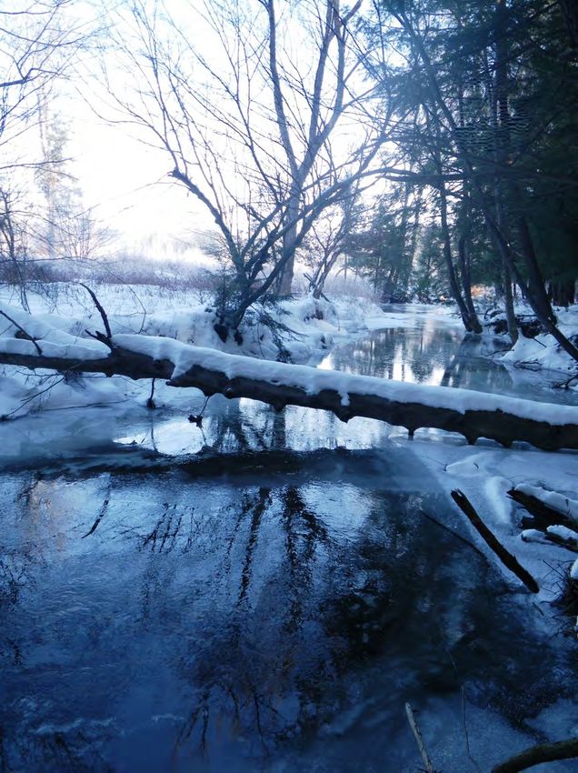
Potts Run AMD Assessment & Restoration Plan                                                  December 2014

Assessment Overview

The purpose of this watershed assessment was to investigate the abandoned mine drainage (AMD)
pollution that is influencing Potts Run, identify other factors that may be affecting the stream, and
develop a restoration plan for the watershed. This report builds off of the Coldwater Conservation Plan
for the Potts Run Watershed, Jordan & Knox Townships, Clearfield County, PA completed by Trout
Unlimited in the fall of 2013. It also includes data and recommendations that were developed by Hedin
Environmental as part of a mine drainage snapshot of Potts Run that was completed through Trout
Unlimited’s AMD Technical Assistance Program for the Knox Township supervisors and finalized in the
spring of 2014.

This watershed assessment was completed through a collaborative effort between Trout Unlimited (TU),
the Clearfield County Conservation District (CCCD) and Hedin Environmental (HE). Funding for the
project was provided by the Coldwater Heritage Partnership, Foundation for Pennsylvania Watersheds,
Growing Greener Grant Program (through the TU AMD Technical Assistance Grant Program), and the
R.K. Mellon Foundation. Additional support was provided by the Clearfield Creek Watershed
Association, DEP Moshannon District Mining Office, DEP Bureau of Abandoned Mine Reclamation, and
Pennsylvania Fish and Boat Commission. A special thank you goes to Carl Undercofler for his help with
all aspects of this project.

Watershed Background

General Information

The Potts Run watershed encompasses 14.5 square miles in Jordan and Knox Townships, Clearfield
County, Pennsylvania (Figure 1). From its source near the village of Ansonville, Potts Run flows
approximately 10.7 miles northeast to its confluence with Clearfield Creek, one mile east of the village of
Kellytown. Potts Run has fifteen miles of tributaries, including Little Potts Run and thirteen unnamed
tributaries. All of the streams within the Potts Run watershed are designated as coldwater fisheries
(CWF) according to PA Code, Title 25, Chapter 93 Water Quality Standards, however, 2.7 miles of Potts
Run and 0.7 miles of Little Potts Run are listed as impaired due to AMD in the DEP’s 2014 Pennsylvania
Integrated Water Quality Monitoring and Assessment Report. An additional 0.4-mile section of the
unnamed tributary numbered 26197 by the DEP is also impaired due to AMD, although for some reason
it is not currently on the impaired waters list. Detailed information about each tributary including the
results of water quality sampling and biological monitoring can be found in the aforementioned
coldwater conservation plan for Potts Run.

The majority of the Potts Run watershed is forested, with large areas of reclaimed and abandoned
surface mining, and a few small pockets of farm land. The area is very rural and contains only a few small
villages, including the former mining towns of Ansonsville, Carnwath, Boardman, and Kellytown.
According to the 2010 United States Census, the combined population of Jordan and Knox Townships is
only 1108, so the actual number of residents in the Potts Run watershed, is even fewer than this. The
watershed has a long and interesting history including being at the center of draft resistance and anti-
war sentiments in Clearfield County during the Civil War and providing coal to fuel industrial revolution
and both world wars (Hughes, 2014).

                                                                                                         1
Potts Run AMD Assessment & Restoration Plan                                                December 2014

Figure 1 Watershed Location Map

Mining Information

Deep mining for coal, and to a lesser extent clay, began in the watershed in the late 1800s with the
opening of mines in Kellytown, Boardman and Carnwath. By the mid-1950s, the last remaining deep
mine was closed and surface mining became the dominant form of natural resource extraction in the
watershed. Prior to the passage of the federal Surface Mining Control and Reclamation Act of 1977, it
was common practice to abandon mining operations once coal reserves were depleted or mining was no
longer economically feasible. This resulted in hundreds of acres of abandoned mine lands (AML) and
dozens of AMD discharges in the Potts Run watershed. While re-mining for coal in the upper and middle
watershed has led to the remediation of many land and water problems in the Potts Run watershed
(Bigatel, 2012), the lower watershed, particularly around the village of Boardman, is still plagued by
AMD discharges and dangerous AML features including mine openings, shafts, highwalls and water filled
pits. For this reason, much of the information in this report focuses on this area.

At the time of this report, there are no active mining activities taking place in the watershed and only
one mine drainage treatment system has been constructed in the watershed. According to the DEP, this
passive treatment system is located on a mine site that was last operated by Al Hamilton Contracting
and is known as the Carnwath Mine. The treatment system was constructed in 2008 using bond
forfeiture funds and consists of a baffled limestone ramp followed by a settling basin, but didn’t go

                                                                                                      2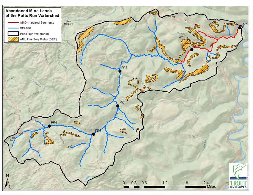
Potts Run AMD Assessment & Restoration Plan                                               December 2014

online until 2013 when a pipeline was extended from the source to the treatment system (Rosengrant,
2014). Historic mining permits, as well as, additional information about the Carnwath Mine treatment
system can be obtained by contacting the DEP’s Moshannon District Mining Office (MDMO).

Methods

Sample Sites

Sample sites were chosen after stream reconnaissance activities and consultation with the DEP’s
MDMO. Over a dozen AMD discharges were located in the watershed, however, only eight of these
were chosen for long-term study. The others were either very small or not flowing at the time of the
study or had marginal water chemistry and were deemed insignificant to the overall water quality of
Potts Run. Sample sites were given names/numbers that correspond to local landmarks or other means
of identifying them. From downstream to upstream they are Little Potts Beaver (LPB), Twin Pines 3
(TP3), Twin Pines 1 (TP1), Route 453 (453), Oak Twins (OT), Oak Join (OJ), Oak Iron (OI), and Potts Run
No. 3 Mine (No. 3). The coordinates and a description of each sampling station can be found in Table 1,
while Figure 2 shows their relative locations within the watershed.

Table 1 Potts Run AMD Discharge Sampling Locations
Sample ID Description                                   Latitude Longitude
LPB           Little Potts Run "Beaver Dam" discharge    40.89069 -78.46915
TP1           Twin Pines Camp discharge 1                40.87875 -78.45812
TP3           Twin Pines Camp discharge 3                40.87762 -78.46086
453           Discharge along SR 453 (Belsena Rd)        40.87624 -78.46218
OT            Oak Ridge Rd "Twin" discharge              40.87106 -78.47099
OJ            Oak Ridge Rd "Join" discharge              40.87165 -78.47217
OI            Oak Ridge Rd "Iron" discharge              40.87105 -78.47320
No. 3         Potts Run No. 3 Mine discharge             40.86975 -78.47440

                                                                                                     3
Potts Run AMD Assessment & Restoration Plan                                                      December 2014

Figure 2 Potts Run Sampling Locations

In addition to the mine discharges, six long-term sampling points were established along the main stem
of Potts Run with additional main stem locations selected for AMD-specific monitoring by Hedin
Environmental. The long-term sampling points are all located at or near stream crossings for ease of
access. The in-stream sampling points are numbered as follows from the mouth to the headwaters: PR1,
PR2, PR3, PR4, PR5, and PR6 (Figure 2). Table 2 provides a description of each main stem sampling
location and the types of monitoring that were completed at each site.

Table 2 Potts Run Main Stem Sampling Locations
                                                                           Water
Sample ID   Description                             Latitude   Longitude Chemistry   Bugs   Habitat   Fish
PR1         Potts Run mouth                         40.89152    -78.44282   X         X       X         X
PR2         Potts Run near Clark Road bridge        40.88215    -78.46947   X         X       X         X
PR3         Potts Run near Reas Lane bridge         40.87273    -78.50942   X         X       X         X
PR4         Potts Run near Fruit Hill Road bridge   40.85795    -78.51041   X         X       X         X
PR5         Potts Run near Brink Road bridge        40.84585    -78.52377   X         X       X         X
PR6         Potts Run near Lawyers Road culvert     40.84919    -78.54844   X                 X        X

                                                                                                             4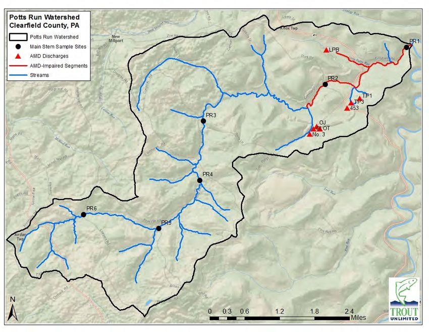
Potts Run AMD Assessment & Restoration Plan                                                  December 2014

Water Quality

Conductivity (umhos), pH (standard units), and water temperature (degrees Celsius) were measured in
the field during all sampling activities using an Oakton multi-parameter PCS Testr 35. The meter was
calibrated for each parameter and rinsed with distilled water prior to all measurements.

Grab samples were collected according to PA DEP protocols at each of the AMD discharges on a monthly
basis while in-stream samples were collected on a quarterly basis from October 2012 to December 2013,
with the exception of PR5 and PR6, which were sampled only twice. Additional grab samples were pulled
from the discharges and additional in-stream locations during both high and low flow conditions in 2012
and 2014 to assess mine influences near the village of Boardman (see Hedin report). Grab samples
consisted of a 500-mL bottle of raw water, one 250-mL bottle of water for metals analyses, and one 250-
ml bottle of water for dissolved metals analyses. The samples for dissolved metals analyses were filtered
through a 0.45 micrometer membrane using a Nalgene Mityvac hand-operated vacuum pump. All
samples for metals analyses were acidified to pH 2 or less with trace metal grade 1 N nitric acid. These
samples were submitted to Mahaffey Laboratory, LLC located in Curwensville, Pennsylvania for further
analysis. Mahaffey Laboratory, LLC is a DEP-certified laboratory and analyzed the grab samples for pH
(standard units), conductivity (umhos), alkalinity (mg/L), acidity (mg/L), total iron (mg/L), total
manganese (mg/L), total aluminum (mg/L), sulfates (mg/L), total dissolved solids (mg/L), and total
suspended solids (mg/L) using PA DEP standard methods. In addition, the in-stream samples were also
analyzed for dissolved iron (mg/L), dissolved aluminum (mg/L), dissolved manganese (mg/L), chloride
(mg/L), calcium (mg/L), and magnesium (mg/L).

A Swoffer Current Velocity Meter was used to measure stream flow according to DEP’s Standardized
Biological Field Collection and Laboratory Methods. Width, velocity at 6/10 depth of the water column,
and depth of water were measured at intervals across the stream so that not more than 1/10 of the
stream velocity was captured per interval. Stream discharge was later calculated by summing the
volume of water moving through each interval. Flows from the AMD discharges were measured using
standard methods including weirs, the timed-volume method (bucket and stop watch), and the above
mentioned velocity meter.

In-stream Habitat Evaluation

Habitat was evaluated for 100 meters at each of the in-stream sample sites using DEP’s Water Quality
Network Habitat Assessment form, which considers the following twelve parameters: in-stream cover,
epifaunal substrate, embeddedness, velocity/depth regimes, channel alteration, sediment deposition,
frequency of riffles, channel flow status, condition of banks, bank vegetative protection, grazing or other
disruptive pressure, and riparian vegetation zone width. These parameters are explained in Appendix A.
Each parameter is given a score (from 0 – 20) based on a visual survey of the sample site. The scores
from each parameter are summed to obtain an overall habitat score. The habitat scoring system is as
follows: the “optimal” category scores from 240 to 192, “suboptimal” from 180-132, “marginal” from
120 – 72, and “poor” is a site with a combined score less than 60. The gaps between these categories
are left to the discretion of the investigator’s best professional judgment. Habitat surveys completed
with this method are subjective to the observer. This bias was overcome by having the same person
perform all of the surveys. Therefore, the results of this study are comparable to one another, but not
necessarily comparable to other habitat surveys completed by different observers.

                                                                                                         5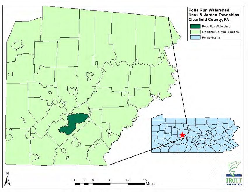
Potts Run AMD Assessment & Restoration Plan                                                  December 2014

Benthic Macroinvertebrates

Benthic macroinvertebrates were collected at five of the main stem sampling locations in November
2013. Benthic macroinvertebrate collections were performed according to the DEP’s Instream
Comprehensive Evaluation (ICE) protocol (specifically section C.1.b. Antidegradation Surveys). In short,
benthic macroinvertebrate samples consisted of a combination of six D-frame efforts in a 100-meter
stream section. These efforts were spread out so as to select the best riffle habitat areas with varying
depths. Each effort consisted of an area of one square meter to a depth of at least four inches as
substrate allowed and was conducted with a 500-micron mesh, 12-inch diameter D-frame kick net. The
six individual efforts were composited and preserved with ethanol for processing in the laboratory. In
samples with greater than 200 individuals, subsamples were taken. Individuals were identified by
taxonomists certified by the North American Benthological Society to genus or the next highest possible
taxonomic level. Samples containing 160 to 240 individuals were evaluated according to the six metrics
comprising the DEP’s Index of Biotic Integrity (IBI) (Total Taxa Richness, EPT Taxa Richness, Beck’s Index
V.3, Shannon Diversity, Hilsenhoff Biotic Index, and Percent Sensitive Individuals. Appendix B contains a
description of each of these six metrics. These metrics were standardized and used to determine if the
stream met the Aquatic Life Use (ALU) threshold for coldwater fishery (Figure 3).

Figure 3 ALU Attainment and Impairment Thresholds for Cold Water Fishes (CWF), Warm Water Fishes
(WWF), and Trout Stocked Fishes (TSF) Protected Uses (Department of Environmental Protection, 2009)

                                                                                                        6
Potts Run AMD Assessment & Restoration Plan                                                  December 2014

Fishery Surveys

Fishery surveys were completed at each of the in-stream sampling locations following PFBC Unassessed
Waters protocol. Surveys were conducted during summer low-flow conditions to minimize sampling bias
and allow for the capture of young-of-year trout. A sampling site approximately 100 meters in length
was selected that included the benthic macroinvertebrate collection site and contained habitat that was
representative of the stream. Each sample site ended at a natural impediment to upstream movement
to minimize sampling bias. A Smith-Root Model LR-24 backpack electro-fishing unit was used to conduct
each survey. Proper current and voltage settings were determined on-site following an evaluation of
conductivity. Single pass electrofishing surveys were completed at each site. All fish captured during the
electrofishing surveys were identified to species. Each species present for the sample site was given an
abundance rating according to the PFBC (< 2 individuals = rare; 2 – 8 individuals = present; 9 – 33
individuals = common; > 33 individuals = abundant). All salmonid species collected were held until the
survey was complete and then measured to the nearest millimeter (total length). Brook trout were also
categorized by size into 25 mm size classes.

Results/Discussion

Water Chemistry – AMD Discharges

As mentioned above, there are numerous AMD discharges in the Potts Run watershed, but only eight of
them were monitored long-term. Table 3 shows the average water chemistry for each of the monitored
discharges. The average water chemistry for all eight discharges exceeded Chapter 93 water quality
standards for one or more parameters. Chapter 93 Water Quality Standards can be found in Table 4.
Additional water chemistry data can be found in Appendix C. Overall, the No. 3 mine discharge
accounted for the greatest pollution loading to Potts Run with average loadings of 299 lbs/day acidity,
13.65 lbs/day iron, 6.83 lbs/day manganese, and 22.18 lbs/day aluminum. For this reason, the No. 3
discharge is the number one priority for restoration of Potts Run. Site LPB has the second highest iron
and manganese load in the watershed; however, the discharge is alkaline in nature and passes through a
natural wetland complex before entering Little Potts Run. Below the wetland, brook trout can be found
in Little Potts Run. The third highest loadings in the watershed come from the TP1 discharge; however,
this discharge is much smaller than the No. 3 mine discharge, which is located upstream. Treatment of
the No. 3 discharge should provide enough buffering capacity to counteract the negative influence of
TP1 on Potts Run. If treatment of the No. 3 discharge does not fully restore Potts Run as expected, then
the TP1 discharge should become the next priority for treatment. The OT and OJ discharges, though
much smaller than the No. 3 discharge, also contain relatively severe chemistry. Due to their close
proximity and interconnectedness to the No. 3 mine discharge, they should be treated in conjunction
with it, if possible. The other discharges in the watershed are not considered a priority at this time due
to the fact that they have relatively little impact on overall water quality in Potts Run, but could be
considered for treatment in the future if funding allows.

                                                                                                        7
Potts Run AMD Assessment & Restoration Plan December 2014
Table 3 Average Water Chemistry of AMD Discharges
Flow Field Lab Cond Alk Acid Acid Load Fe Fe Load Mn Mn Load Al Al Load SO4
Site ID (gpm) pH pH (uS) (mg/L) (mg/L) (lbs/day) (mg/L) (lbs/day) (mg/L) (lbs/day) (mg/L) (lbs/day) (mg/L)
LPB 145 5.66 6.46 528 48 -18 -34 8.80 16.18 4.98 7.71 0.10 0.21 185
TP3 14 5.97 6.26 307 15 5 1 1.23 0.19 0.81 0.13 0.08 0.03 110
TP1 44 3.17 3.76 789 0 46 25 2.15 1.29 6.04 3.13 3.51 1.85 330
453 10 4.69 5.15 610 6 24 2 0.77 0.06 8.26 0.76 0.50 0.06 229
OT 53 2.99 3.50 713 0 72 50 0.89 0.49 6.59 4.70 7.06 4.68 296
OJ 9 3.32 3.91 386 0 42 4 0.18 0.01 3.00 0.25 4.23 0.30 149
OI 3 5.26 6.04 648 16 34 1 18.60 0.42 4.49 0.11 0.26 0.01 253
No. 3 208 3.03 3.03 859 0 130 299 4.77 13.65 3.21 6.83 10.54 22.18 282
Results highlighted in yellow do no meet Chapter 93 water quality criteria.
Table 4 Chapter 93 Water Quality Standards
Parameter Criteria Value Notes
Alkalinity ≥20 mg/L
Aluminum (Al) ≤0.75 mg/L Total Recoverable
Chloride ≤250 mg/L
Iron (Fe) ≤1.5 mg/L Total Recoverable
Manganese (Mn) ≤1.0 mg/L Total Recoverable
pH 6.0-9.0 SU
Sulfate ≤250 mg/L
TDS ≤750 mg/L
Water Chemistry – Main Stem of Potts Run
Six in-stream sampling locations were established on the main stem of Potts Run. Table 5 shows the
average water chemistry at these locations. Average water quality at all six sites met Chapter 93 criteria
with the exception of PR5, which had slightly elevated sulfate levels. Average aluminum, iron, and
manganese concentrations are elevated at both in-stream locations below the No. 3 Mine discharge
(PR1 and PR2), but still fall within acceptable limits. Otherwise, the stream is net alkaline from
headwaters to mouth, and exhibits relatively good average water quality. Additional water chemistry
data for these sites can be found in Appendix D.
Table 5 Average In-stream Water Chemistry of Potts Run
Diss. Diss. Diss.
Site Flow Field Lab Cond Temp Alk Acid Acid Load Fe Fe Load Mn Mn Load Al Al Load SO4 TSS TDS Fe Al Mn Ca Mg Chloride
ID (gpm) pH pH (uS) (oC) (mg/L) (mg/L) (lbs/day) (mg/L) (lbs/day) (mg/L) (lbs/day) (mg/L) (lbs/day) (mg/L) (mg/L) (mg/L) (mg/L) (mg/L) (mg/L) (mg/L) (mg/L) (mg/L)
PR1 1864 6.69 7.0 486.3 7.6 46 -26 -340 0.37 10.10 0.43 10.02 0.32 10.19 175 BD 333 BD BD 0.34 58.82 19.49 10.6
PR2 1441 7.03 7.4 518 6.9 57 -38 -382 0.41 7.14 0.64 8.85 0.49 9.80 187 6.8 336 BD 0.18 0.61 66.88 19.88 10.5
PR3 981 7.30 7.6 643.3 7.0 93 -74 -512 0.24 2.20 0.07 0.74 0.07 0.82 221 6.0 430 BD BD 0.06 93.44 24.55 9.4
PR4 827 7.50 7.7 700.8 7.4 104 -88 -605 0.23 1.86 0.06 0.58 BD -- 242 BD 476 BD BD 0.05 105.22 27.23 9.0
PR5 517 7.81 8.2 875.5 8.2 138 -120 -777 0.19 1.13 0.09 0.51 BD -- 309 BD 623 0.07 BD 0.08 128.73 34.49 7.6
PR6 77 7.58 8.1 705.5 8.0 167 -152 -143 0.27 0.26 0.07 0.07 BD -- 175 BD 470 0.08 BD 0.07 102.43 27.46 12.8
Note: BD indicates parameter was below detection limit. Results highlighted in yellow do not meet Chapter 93 water quality
criteria.
Habitat
The results from the in-stream habitat assessments are provided in Table 6. Three of the six locations
that were evaluated for habitat received total scores in the optimal range, while the other three
8Potts Run AMD Assessment & Restoration Plan December 2014
received scores in the sub-optimal range indicating that habitat throughout the watershed is relatively
good. The PR1 sampling location received the highest habitat score, with all parameters scoring in the
optimal or sub-optimal range. The PR6 sampling location received the lowest habitat score, due to poor
scores for the in-stream cover, epifaunal substrate, velocity/depth regimes, and frequency of riffles
parameters. It should be noted that the stream at PR6 flows through a large beaver
impoundment/wetland complex that was breached sometime in the last few years. The stream is still
trying to establish a new channel through the wetland area, leading to many of the poor scores during
the habitat assessment. Only two sampling locations received poor scores for any parameter: PR3 for in-
stream cover and PR6 for the above mentioned parameters. All six sampling locations scored below
optimal in the embeddedness parameter, while three locations scored below optimal in the sediment
deposition parameter. Poor scores for these two parameters are of greater concern because of their
ability to influence in-stream benthic macroinvertebrate populations, and in turn, fish populations. See
Appendix 1 for a more thorough explanation of these parameters. Several likely sources of sediment to
Potts Run were identified during this assessment and development of the coldwater conservation plan
including streambank erosion, abandoned mine lands, dirt and gravel roads, and down-cutting of the
stream through sediments deposited in formerly impounded areas. Addressing these sources of
sediment will improve in-stream habitat in the watershed and should lead to increased populations of
macroinvertebrates and fish.
Table 6 Potts Run Habitat Assessment Results
Parameter PR1 PR2 PR3 PR4 PR5 PR6
Instream Cover (Fish)* 20 8 5 14 9 5
Epifaunal Substrate* 20 16 12 20 8 3
Embeddedness* 13 9 8 9 7 10
Velocity/Depth Regimes 14 17 9 18 7 4
Channel Alteration 20 15 20 18 20 17 Optimal
Sediment Deposition* 16 19 10 13 15 17 Suboptimal
Frequency of Riffles 17 19 9 17 8 2 Marginal
Channel Flow Status 16 18 13 13 20 20 Poor
Condition of Banks 20 19 19 17 20 14
Bank Vegetative Protection 20 20 20 20 20 20
Grazing or Other Disruptive Pressure 20 20 20 20 20 20
Riparian Vegetative Zone Width 20 20 20 20 19 16
Total Score 216 200 165 199 173 148
Macroinvertebrates
Benthic macroinvertebrates were collected at five of the six in-stream sampling sites as outlined in the
methods. A macroinvertebrate survey was not completed at PR6 due to the lack of appropriate habitat.
A full list of the taxa collected, their abundance, and the pollution tolerance value (PTV) (based on PA
DEP data) for each site is provided in Appendix E. Pollution tolerances of the taxa increase as the PTV
increases. For example, taxa with a PTV of 6 are more tolerant to anthropogenic pollution than taxa with
a PTV of 2. PTV values were developed by DEP using primarily organic sources of pollution and do not
reflect the tolerance of the organism to acid derived pollution. (I.e. in acidified streams, the IBI score
may be inflated due to the presence of acid tolerant genera that have a low PTV for organic pollution.)
9Potts Run AMD Assessment & Restoration Plan December 2014
Overall, the most abundant families in these samples were Elmidae (Order Coleoptera) Hydropsychidae
(Order Trichoptera) and Chironomidae (Order Diptera) (Appendix E). All three of these families are
relatively tolerant to anthropogenic pollution with PTVs of 5, 5, and 6, respectively.
The biological metrics calculated for each sample site are provided in Table 7. Detailed descriptions of
these metrics are provided in Appendix B. The PR1 and PR4 sampling locations both met attaining life
use criteria according to the ALU assessment decision tree found in the methods. PR1 had an IBI score of
65, automatically meeting the criteria for attaining ALU (IBI > 62). Although the IBI score for PR4 was
only 52.9, it contained a fairly high percentage of sensitive individuals which show that it is attaining its
designated ALU. The PR5 site was close to meeting the ALU criteria (IBI = 56.4) but did not meet the
conditions found in the decision tree to be considered as attaining its designated ALU. This stream
location should be re-evaluated in the future for ALU attainment, as continuing habitat improvements in
the upstream reaches containing the breached beaver impoundment may be enough to change its ALU
designation to attaining. One site (PR2) did not contain enough individuals in order for the IBI to be
calculated, and the remaining site, PR3, had an IBI score (33.6) that indicates that it is not meeting its
designated aquatic life use of CWF. Site PR2 is located directly downstream from the No. 3 mine
discharge and there is a great deal of aluminum precipitate on the substrate in this area that may be
affecting macroinvertebrates. Site PR3 is located just upstream of the Rea’s Lane bridge where the
stream is very low gradient and contains a long run and deep pool where sediment from upstream is
deposited.
Taxa richness varied among sites, ranging between 16 and 29 taxa. The PR5 sample site contained the
greatest number of taxa (29 taxa), followed by PR1 (26 taxa). The PR2 site had the fewest number of
taxa observed (16 taxa). The number of taxa belonging to the orders Ephemeroptera, Plecoptera, and
Trichoptera (EPT taxa) accounted for 41.2% of the total number of individual organisms collected
(Appendix E). The presence of EPT taxa in samples is generally an indicator of adequate water chemistry
and habitat availability for these organisms.
Table 7 Benthic macroinvertebrate biometric results. See Appendix B for detailed descriptions.
PR1 PR2 PR3 PR4 PR5
Total Taxa Richness 26 16 18 21 29
EPT Taxa Richness 12 6 1 6 8
Beck's Index V.3 20 10 4 11 13
Hilsenhoff Biotic Index 4.24 4.04 5.03 4.22 4.38
Shannon Diversity Index 2.32 2.21 1.91 2.43 2.44
Percent Sensitive Individuals 36.6 33.8 2.6 31.3 16.7
IBI Score 65 N/A 33.6 52.9 56.4
Note: N/A indicates that the IBI could not be calculated because the sample contained fewer than 200 +/- 40 individuals;
therefore the stream at this location does not meet the criteria for ALU attainment.
Fish
Fishery surveys were completed at all six in-stream sampling locations during August of 2013 and 2014.
The species and abundance of fish captured can be found in Table 8. Overall, the most abundant species
was the creek chub (Semotilus acromaculatus) followed by the blacknose dace (Rhynichthys atratulus).
Brook trout were found at only one main stem location, PR5, during this study. The size distribution for
the trout at this location can be found in Figure 4. However, it should be noted that during development
10Potts Run AMD Assessment & Restoration Plan December 2014
of the Potts Run Coldwater Conservation Plan, brook trout surveys were completed on all of the
tributaries to Potts Run, seven of which contained brook trout and are now awaiting final approval by
the PFBC for inclusion on the Wild Trout list. Young-of-year brook trout were collected at six of these
sites, confirming that reproduction is occurring in the watershed. Additionally, during angler surveys in
the spring of 2013 and 2014, numerous brook trout were caught by two different anglers in the section
of Potts Run between PR1 and PR2. One brook trout was caught on the main stem of Potts Run between
PR2 and PR3 during an unassessed waters survey in August 2012, and visual observations of brook trout
have occurred at various times of the year throughout the main stem of Potts Run.
Site PR5 had the highest species richness with six species present, followed by PR3 and PR1, each with
five species present. Site PR2 (downstream of the No. 3 mine discharge) had the lowest species richness
with only two species present.
Table 8 Fish Abundance and Species Richness at Potts Run Main Stem Sampling Sites
Common Name Species PR1 PR2 PR3 PR4 PR5 PR6
Blacknose Dace Rhinichthys atratulus 1 2 15 12 15
Brook Trout Salvelinus fontinalis 4
Creek Chub Semotilus atromaculatus 1 9 10 20 30+ 22
Green Sunfish Lepomis cyanellus
Longose Dace Rhinichthys cataractae 1
Margined Madtom Noturus insignis 2 1
Northern Hogsucker Hypentelium nigricans 1 4
Pumpkinseed Lepomis gibbosus 4 4 1
Rock Bass Ambloplites rupestris 2
Tesselated Darter Etheostoma olmstedi 1 2 1
White Sucker Catostomus commersonii 1
Species Richness 5 2 5 4 6 3
Figure 4: Brook Trout Size Distribution at Site PR5
11Potts Run AMD Assessment & Restoration Plan December 2014
AMD Restoration
As stated above, Hedin Environmental completed an AMD “snapshot” of the Potts Run watershed for
the Knox Township Supervisors through TU’s AMD Technical Assistance Program. A copy of this report
can be found in Appendix F. The findings of the snapshot report agree with the data collected during this
assessment and point to the Potts Run No. 3 deep mine discharge as the main contributor of acidity and
metal loadings to Potts Run. Treatment of the No. 3 deep mine will restore 0.4 miles of the unnamed
tributary (UNT26197) to which it flows, along with the entire 2.7-mile section of Potts Run that is
currently listed as impaired.
Water quality data indicates that the No. 3 discharge can be treated passively using a vertical flow pond
(VFP) system and wetlands/settling basins. Hedin Environmental proposes to build a collection system
that will gather the water from the No. 3, OT, and OJ discharges and pipe them to land on the northwest
side of Oak Ridge Road for treatment. This area is currently occupied by the No. 3 refuse pile, but it is
hoped that this pile can be removed/reclaimed and the area used for construction of the treatment
system to avoid disturbing additional ground and impacting wetlands. If this is not possible, the system
will be shifted slightly further to the northwest to an upland area that was previously disturbed by clear-
cut logging. Please see Figure 3 in the attached report (Appendix F) for a schematic of the proposed
treatment system.
Treatment of the No. 3 mine discharge will prevent an average of nearly 300 lbs/day acidity, 14 lbs/day
iron, 7 lbs/day manganese, and 22 lbs/day of aluminum from entering UNT26197 and Potts Run,
restoring water quality and further enhancing aquatic life in the stream. These improvements in water
quality will also aid in the biological recovery of the stream. Macroinvertebrate and fish populations that
are downstream of this discharge should begin to recover almost immediately once water quality is
improved. Future biological monitoring should show an increase in macroinvertebrate IBI scores, fish
abundance, and fish species richness. Please see Appendix F for the full report including cost estimates
for the proposed treatment system.
Abandoned Mine Land (AML) Inventory
In addition to the water quality sampling and biological monitoring that took place as part of this
assessment, an effort was made to investigate AML areas in the watershed (Figure 5) and determine
their reclamation status. Through these efforts, several AML features in the watershed, including
abandoned highwalls near the village of Boardman, have been upgraded from Priority 3 (P3) to Priority 2
(P2) status due to their near-vertical nature and close proximity to residences. TU worked with the
property owners (heirs of the Potts Run Coal Company) and DEP Bureau of Abandoned Mine
Reclamation (BAMR) officials to investigate these highwalls and adjacent coal refuse piles. A reclamation
plan for the area is now in the development stages and will complement any water quality
improvements that are made through remediation of the No 3. Mine discharge. In the middle and upper
portion of the watershed, it appears that several AML features have been reclaimed through remining
activities in the past decade or so. Additionally, during the course of this study, BAMR completed a
surface reclamation and stream reconstruction project on an abandoned mine site just south of the
village of Ansonville in Jordan Township, where the headwaters of Potts Run flowed through an
abandoned surface mine. In the future, efforts should be made to work with additional landowners and
BAMR, to reclaim additional priority AML areas in the watershed, further improving public safety and
enhancing the watershed.
12Potts Run AMD Assessment & Restoration Plan December 2014
Figure 5 AML Features in the Potts Run Watershed
Additional Recommendations
In addition to the AMD/AML restoration activities mentioned above, it is recommended that additional
work be completed that would enhance the in-stream and riparian habitat found within the Potts Run
watershed. Data gathered during this study and development of the coldwater conservation plan have
indicated that in addition to AMD, sedimentation and elevated summer water temperatures may be
contributing to the depressed macroinvertebrate and fish populations found at several of the Potts Run
sampling locations. It is recommended that additional projects such as riparian plantings, reclamation of
spoil and refuse piles, streambank stabilization projects, dirt and gravel road improvements, and fish
habitat enhancement projects be implemented to address these issues.
Also, at this time, there are no public lands located in the Potts Run watershed. The Pennsylvania Game
Commission is currently negotiating with a private landowner to acquire 1200 acres near the village of
Boardman that would provide access to several miles of Potts Run, as well as, frontage along Clearfield
Creek. It is recommended that other environmentally and/or recreationally significant areas be
identified in the watershed and a plan developed to provide public access and/or land protection to
these areas through easements or acquisitions.
13Potts Run AMD Assessment & Restoration Plan December 2014 APPENDIX A Description of Habitat Parameters Instream Fish Cover Evaluates the percent makeup of the substrate (boulders, cobble, other rock material) and submerged objects (logs, undercut banks) that provide refuge for fish. Epifaunal Substrate Evaluates riffle quality, i.e., areal extent relative to stream width and dominant substrate materials that are present. (In the absence of well-defined riffles, this parameter evaluates whatever substrate is available for aquatic invertebrate colonization.) Embeddedness Estimates the percent (vertical depth) of the substrate interstitial spaces filled with fine sediments. (Pool substrate characterization: evaluates the dominant type of substrate materials, i.e., gravel, mud, root mats, etc. that are more commonly found in glide/pool habitats.) Velocity/Depth Regime Evaluates the presence/absence of four velocity/depth regimes - fast-deep, fast-shallow, slow-deep and slow-shallow. (Generally, shallow is
Potts Run AMD Assessment & Restoration Plan                                                   December 2014

Grazing or Other Disruptive Pressures
Evaluates disruptions to surrounding land vegetation due to common human activities, such as crop
harvesting, lawn care, excavations, fill, construction projects and other intrusive activities.

Riparian Vegetative Zone Width
Estimates the width of protective buffer strips or riparian zones. This is a rating of the buffer strip with
the least width.

                                                                                                         15
Potts Run AMD Assessment & Restoration Plan December 2014
APPENDIX B Description of Biological Metrics
Total Abundance
The total abundance is the total number of organisms collected in a sample or sub-sample.
Dominant Taxa Abundance
This metric is the total number of individual organisms collected in a sample or sub-subsample that
belong to the taxa containing the greatest numbers of individuals.
Taxa Richness
This is a count of the total number of taxa in a sample or sub-sample. This metric is expected to
decrease with increasing anthropogenic stress to a stream ecosystem, reflecting loss of taxa and
increasing dominance of a few pollution-tolerant taxa.
% EPT Taxa
This metric is the percentage of the sample that is comprised of the number of taxa belonging to the
orders Ephemeroptera, Plecoptera, and Trichoptera (EPT). Common names for these orders are
mayflies, stoneflies, and caddisflies, respectively. The aquatic life stages of these three insect orders are
generally considered sensitive to, or intolerant of, pollution (Lenat and Penrose 1996). This metric is
expected to decrease in value with increasing anthropogenic stress to a stream ecosystem, reflecting
the loss of taxa from these largely pollution-sensitive orders.
Shannon Diversity Index
The Shannon Diversity Index is a community composition metric that takes into account both taxonomic
richness and evenness of individuals across taxa of a sample or sub-sample. In general, this metric is
expected to decrease in value with increasing anthropogenic stress to a stream ecosystem, reflecting
loss of pollution-sensitive taxa and increasing dominance of a few pollution-tolerant taxa.
Hilsenhoff Biotic Index
This community composition and tolerance metric is calculated as an average of the number of
individuals in a sample or sub-sample, weighted by pollution tolerance values. The Hilsenhoff Biotic
Index was developed by William Hilsenhoff (Hilsenhoff 1977, 1987; Klemm et al. 1990) and generally
increases with increasing ecosystem stress, reflecting dominance of pollution-tolerant organisms.
Pollution tolerance values used to calculate this metric are largely based on organic nutrient pollution.
Therefore, care should be given when interpreting this metric for stream ecosystems that are largely
impacted by acidic pollution from abandoned mine drainage or acid deposition.
Beck’s Biotic Index
This metric combines taxonomic richness and pollution tolerance. It is a weighted count of taxa with
PTVs of 0, 1, or 2. It is based on the work of William H. Beck in 1955. The metric is expected to decrease
in value with increasing anthropogenic stress to a stream ecosystem, reflecting the loss of pollution-
sensitive taxa.
Percent (%) Sensitive Individuals
This community composition and tolerance metric is the percentage of individuals with PTVs of 0 to 3 in
a sample or sub-sample and is expected to decrease in value with increasing anthropogenic stress to a
stream ecosystem, reflecting the loss of pollution-sensitive organisms
16Potts Run AMD Assessment & Restoration Plan December 2014
Appendix C Water Chemistry of Potts Run AMD Discharges
Site Flow Field Lab Cond Alk Acid Acid Load Fe Fe Load Mn Mn Load Al Al Load SO4 TSS TDS
ID Date (gpm) pH pH (uS) Temp (mg/L) (mg/L) (lbs/day) (mg/L) (lbs/day) (mg/L) (lbs/day) (mg/L) (lbs/day) (mg/L) (mg/L) (mg/L)
06/26/12 -- 5.78 6.5 607 -- 34 -15 -- 4.56 -- 5.94 -- 0.10 -- 244 8.0 426
12/18/12 -- 6.56 6.3 519 5.4 50 -18 -- 5.82 -- 5.27 -- 0.06 -- 191Potts Run AMD Assessment & Restoration Plan December 2014
Appendix C (Continued)
Site Flow Field Lab Cond Alk Acid Acid Load Fe Fe Load Mn Mn Load Al Al Load SO4 TSS TDS
ID Date (gpm) pH pH (uS) Temp (mg/L) (mg/L) (lbs/day) (mg/L) (lbs/day) (mg/L) (lbs/day) (mg/L) (lbs/day) (mg/L) (mg/L) (mg/L)
06/26/12 7 3.59 4.0 333 -- 0 32 3 0.06 0.01 2.52 0.21 2.70 0.23 121Potts Run AMD Assessment & Restoration Plan December 2014
Appendix D Water Chemistry of Potts Run In-stream Sampling Locations
Diss. Diss. Diss.
Site Flow Field Lab Cond Temp Alk Acid Acid Load Fe Fe Load Mn Mn Load Al Al Load SO4 TSS TDS Fe Al Mn Ca Mg Chloride
ID Date (gpm) pH pH (uS) (oC) (mg/L) (mg/L) (lbs/day) (mg/L) (lbs/day) (mg/L) (lbs/day) (mg/L) (lbs/day) (mg/L) (mg/L) (mg/L) (mg/L) (mg/L) (mg/L) (mg/L) (mg/L) (mg/L)
10/23/12 893 6.67 7.7 583 9.0 57 -41 -439Potts Run AMD Assessment & Restoration Plan December 2014
Appendix E Macroinvertebrate Data for the Potts Run Watershed
Order Family PA Taxon PA PTV PR1 PR2 PR3 PR4 PR5
Oligochaeta 10 2 2 3 1
Hydracarina 7 1 1 8 12 8
Coleoptera Elmidae Optioservus 4 7 7 84 53 88
Oulimnius 5 2 14 5
Stenelmis 5 1 2 12
Dubiraphia 6 3 1
Diptera Ceratopogonidae Ceratopogonidae 6 1 1
Dasyhelea 6 3
Chironomidae Chironomidae 6 65 26 46 36 15
Empididae Hemerodromia 6 8 8 6 6
Simuliidae Prosimulium 2 1 9 3
Tipulidae Dicranota 3 2 4
Hexatoma 2 3
Tipula 4 1 1
Antocha 3 2 4 7 4
Athericidae Atherix 2 1
Ephemeroptera Ameletidae Ameletus 0 1 1
Baetidae Baetis 6 8
Ephemerellidae Eurylophella 4 1 1
Heptageniidae Epeorus 0 1
Maccaffertium 3 7
Caenidae Caenis 7 1 1
Megaloptera Corydalidae Nigronia 2 1 2
Sialidae Sialis 6
Odonata Gomphidae Gomphidae 4 1 4 5
Calopterygidae Calopteryx 6 1
Aeschnidae Boyeria 2 1
Plecoptera Capniidae Allocapnia 3 21 2 3 2
Chloroperlidae Chloroperlidae 0 2
Sweltsa 0 1
Leuctridae Leuctra 0 2 4
Perlidae Acroneuria 0 2
Agnetina 2 4
Perlodidae Isoperla 2 9
Taeniopterygidae Taeniopteryx 2 36 5 38 5
Taeniopterygidae 2 3 3 12
Trichoptera Hydropsychidae Ceratopsyche 5 49 3 3 6 31
Cheumatopsyche 6 1 51 19 17
Diplectrona 0 2 6
Hydropsyche 5 4 2 10 2 7
Limnephilidae Limnephilidae 4 3
Philopotamidae Chimarra 4 2
Dolophilodes 0 7
Polycentropodidae Polycentropus 6 1
Psychomyiidae Psychomyia 2 1
Rhyacophilidae Rhyacophila 1 3 1
Glossosomatidae Glossosoma 0 1
Phryganeidae Oligostomis 5
Nematoda 9 3 1
Tetrastemmatidae Prostoma 6 1 2 2
238 68 234 233 239
20Potts Run AMD Assessment & Restoration Plan December 2014
Appendix F Potts Run AMD Snapshot Report by Hedin Environmental
21Potts Run AMD Assessment & Restoration Plan December 2014
Potts Run Restoration Plan, Existing AMD and Treatment Opportunities
Technical Report Provided by Hedin Environmental through the Trout Unlimited AMD
Technical Assistance Program
June 2014
Background
This Trout Unlimited (TU) Technical Assistance project addresses acid mine drainage (AMD) pollution
in the Potts Run watershed. Initially, the assistance involved the establishment of monitoring points in
the Potts Run watershed that would be sampled by TU staff. This work was completed in June 2012.
However, as TU investigated restoration options it became clear that both PA DEP and a private mining
company were planning to work in the watershed. For this reason, the scope of the project was
expanded to include technical assistance in coordinating an effort to consolidate and add urgency to the
various reclamation efforts. The monitoring effort was expanded to include a full round of sampling
under higher flow spring conditions and the preparation of a restoration plan. That plan is being
prepared by TU and will include the AMD assessment and treatment recommendations from this report.
Potts Run Watershed
Potts Run is a tributary to Clearfield Creek in southern Clearfield County (Figure 1). Designated a cold
water fishery, the lower 2.7 miles is listed as impaired due to AMD. Several abandoned unreclaimed
surface and deep mines in the Brookville, Clarion and Lower Kittanning coals exist in the watershed.
Recent observations have indicated that aquatic life is returning to the watershed but impairment
remains in the lower reach.
Figure 1. Potts Run Watershed
22Potts Run AMD Assessment & Restoration Plan December 2014
Water Quality Sampling Results
At least ten AMD discharges have been identified in the watershed. To determine the relative impact of
these discharges, Hedin Environmental (HE) staff assisted TU with the establishment of a monitoring
plan by performing a watershed snapshot on June 26, 2012, during low flow conditions. The snapshot
focused on the lower third of the watershed where there is visible impairment (staining) by AMD.
Following this snapshot, monitoring was conducted by Trout Unlimited and local watershed volunteers.
Then on April 2, 2014 a second snapshot was conducted under flow conditions. Figure 2 shows the
locations of the samples. Table 1 compares the flow conditions of the two snapshots.
Table 1. Comparison of snapshot flow conditions (gpm).
Sampling Point ID 6/26/12 4/2/14
Potts Run above Oak Ridge Tributary 1,198 11,025
Oak Twin Discharge 41 167
Oak Join Discharge 7 2.5
No. 3 Mine Discharge 278 743
Oak Ridge Tributary 350 1,331
Twin Pines 1 Discharge 52 64
453 Discharge 7 17
Potts Run Above Little Potts Run 1,481 12,350
Little Potts Run Mouth 171 968
In-stream water quality data show that Potts Run is net alkaline throughout the study area under both
low and high flow conditions (Table 2). The alkaline condition allows the stream to assimilate AMD
inputs but the presence of AMD in the watershed is evidenced by elevated sulfate and metal
concentrations. With circumneutral in-stream pH the iron and aluminum measured are likely particulate
(samples were not filtered before acidification) and not as directly toxic as occurs when these metals are
dissolved. The segment with the worst water quality is downstream of the Oak Ridge tributary. Despite
the AMD inputs, the alkaline water quality suggests that the stream is capable of recovery with only
moderate improvement.
Table 2. In-stream conditions during the two flow sampling event, June 26, 2012
Sample ID Flow pH Alk Acid Fe Mn Al SO4
gpm mg/L CaCO 3 ----- mg/L -----
Low Flow Event, June 26, 2012
Potts Run above Oak Ridge Tributary 1,198 7.7 78 -59 0.5 0.4 0.1 196
Potts Run below Oak Ridge Tributary 1,400 7.0 44 -22 1.2 1.1 1.8 206
Potts Run above Little Potts Run 1,481 7.4 38 -19 0.3 1.0 0.4 208
Little Potts Run Mouth 171 7.1 25 -6 0.1 0.1 0.0 197
High Flow Event, April 2, 2014
Potts Run above Oak Ridge Tributary 11,025 7.3 29 4 0.3 0.1 0.2 72
Potts Run below Oak Ridge Tributary 12,356 6.9 21 10 0.6 0.3 0.7 82
Potts Run above Little Potts Run 12,350 7.1 19 6 0.5 0.4 0.7 84
Little Potts Run Mouth 968 7.1 18 9 0.3 0.5 0.2 73
23Potts Run AMD Assessment & Restoration Plan December 2014
Figure 2. Sampling points in the Potts Run watershed.
24Potts Run AMD Assessment & Restoration Plan December 2014
Flow from the Oak Ridge tributary degrades a portion of Potts Run immediately below the confluence
where iron, aluminum and manganese all exceed in-stream limits. Table 3 shows the chemistry of Potts
Run and the AMD-polluted Oak Ridge tributary. The strongly alkaline condition of Potts Run above the
Oak Ridge tributary allows the pollution loading to be assimilated fairly quickly with iron and aluminum
falling to levels similar to the upstream condition at the Potts Run above Little Potts station. Likewise,
Little Potts Run was found to be net alkaline at the mouth but with slightly elevated metals
concentrations. Comparing water quality between high and low flow conditions shows that pH is
higher and acidity lower under low flow conditions but metals concentrations are higher. This is largely
due to a combination of higher upstream alkalinity concentration under low flow and the Potts Run
upstream to Oak Ridge tributary flow ratio which was 8:1 under high flow but only 3:1 under low flow.
Table 3. Snapshot in-stream water quality summary.
Site Potts Run Oak Ridge Potts Run Below Potts Run Above Little Potts
Upstream Trib Oak Ridge Trib Little Potts Run Run Mouth
Flow 11,025 1,198 1,331 350 12,350 1,400 12,350 1,481 968 171
pH 7.3 7.7 3.3 3.1 6.9 7.0 7.1 7.4 7.1 7.1
Alk. 29 78 0 0 21 44 19 38 18 25
Acid* -27 -76 61 95 -15 -30 -14 -33 -16 -25
Fe 0.3 0.5 2.9 4.0 0.6 1.2 0.5 0.3 0.3 0.1
Mn 0.1 0.4 2.0 3.9 0.3 1.1 0.4 1.0 0.5 0.1
Al 0.2 0.1 4.9 7.4 0.7 1.8 0.7 0.4 0.2 ND
SO4 72 196 176 231 82 206 84 208 73 197
*Acidity value calculated from pH, metals and alkalinity concentrations.
Units: flow gpm, pH S.U., all others mg/L. ND = below detection
Flow rates and concentrations were multiplied to calculate loadings for both days (Table 4). The Oak
Ridge tributary produced large loads of acidity and Al and lesser loads of Fe and Mn. Al and Fe form
solids in the alkaline circumneutral waters in Potts Run and their loadings are not conservative. Mn and
sulfate do not form solids under these conditions and their loadings are useful for tracking inputs to the
stream. Table 5 shows the summed loading of Potts Run upstream and the Oak Ridge tributary as a
percentage of the loading measured at Potts Run above Little Potts Run. Sulfate and manganese are
essentially fully accounted for (within the expected error of measurements) while iron and aluminum are
over accounted (i.e. >100% capture) as expected. These data indicate that there are no other significant
sources of AMD in the watershed other than the Oak Ridge tributary.
25Potts Run AMD Assessment & Restoration Plan December 2014
Table 4. Snapshot in-stream loading summary.
Site Potts Run Oak Ridge Potts Run Below Potts Run Above Little Potts
Upstream Trib Oak Ridge Trib Little Potts Run Run Mouth
Flow 11,025 1,198 1,331 350 12,350 1,400 12,350 1,481 968 171
Alk. 3,837 1,121 0 0 3,114 739 2,816 675 209 51
Acid* -3,621 -1,089 972 399 -2,283 -507 -2,021 -593 -183 -50
Fe 33.1 6.9 45.5 16.8 83.0 19.3 77.1 4.8 2.9 0.2
Mn 17.2 5.0 32.6 16.5 48.9 18.1 62.2 18.1 5.9 0.2
Al 22.5 2.0 77.6 31.0 106.8 29.6 97.8 7.5 1.7 0.0
SO4 9,526 2,818 2,811 970 12,158 3,461 12,449 3,697 848 404
*Acidity value calculated from pH, metals and alkalinity concentrations.
Units: flow gpm, all others are pounds per day
Table 5. Loadings as percentage of loading at Potts Run above Little Potts Run
Site Potts Run Upstream Oak Ridge Trib Potts Run Below
Date 04/02/14 06/26/12 04/02/14 06/26/12 04/02/14 06/26/12
Flow 89% 81% 11% 24% 100% 105%
Alkalinity 136% 166% 0% 0% 136% 166%
Acidity 179% 184% -48% -67% 131% 116%
Fe 43% 144% 59% 350% 102% 494%
Mn 28% 28% 52% 91% 80% 119%
Al 23% 27% 79% 415% 102% 442%
SO4 77% 76% 23% 26% 99% 102%
Oak Ridge Tributary
The Oak Ridge tributary accounts for nearly all of the AMD pollution in the lower part of the watershed.
The stream is shown as Coder Run in historic mine maps but this name is not shown on the USGS
Ramey, PA quadrangle. The PA DEP name for this stream is unnamed tributary (UNT) 26197. There
are two main AMD discharges in the Oak Ridge tributary watershed as well as several small seeps.
Both surface and deep mining on multiple seams are present in the watershed. The entry to the Potts
Run No. 3 deep mine in the Lower Kittanning is located along Oak Ridge Road (SR 2015) southwest of
the village of Boardman and the associated refuse pile can be found opposite the entry.
Data collected for the Oak Ridge tributary AMD sources during the two watershed snapshots are shown
in Table 6. All three discharges are acidic with depressed pH and elevated concentrations of manganese
and aluminum. Only the No. 3 Mine discharge contains significant iron concentrations.
26Potts Run AMD Assessment & Restoration Plan December 2014
Table 6. Flow and water chemistry for Oak Ridge Tributary (mouth) and three AMD
Discharges.
Site Oak Twin Discharge Oak Join Discharge No. 3 Mine Oak Ridge Trib
Date 04/02/14 06/26/12 04/02/14 06/26/12 04/02/14 06/26/12 04/02/14 06/26/12
Flow 167 41 3 7 743 278 1,331 350
pH 3.5 3.5 4.0 4.0 3.1 3.0 3.3 3.1
Alkalinity 0 0 0 0 0 0 0 0
Acidity* 59 71 17 25 102 112 61 95
Fe 0.5 0.9 0.1 0.1 6.5 4.7 2.9 4.0
Mn 5.6 8.7 1.7 2.5 2.5 2.8 2.0 3.9
Al 5.9 6.8 1.6 2.7 8.3 8.7 4.9 7.4
Sulfate 268 343 93 121 252 228 176 231
*Acidity value calculated from pH, metals and alkalinity concentrations.
Units: flow gpm, pH S.U., all others mg/L.
Contaminant loadings within the Oak Ridge tributary subwatershed were calculated to determine the
proportion that is accounted for by the three known discharges and to assess the potential for loading
reduction to the tributary and Potts Run (Table 7). The three identified AMD discharges account for all
of the acidity, sulfate, and metals measured at the tributary mouth. There are no unidentified significant
sources of AMD in the subwatershed.
Table 7. Flow (gpm) and loadings (lb/day) summaries for AMD sources in the
Oak Ridge tributary subwatershed. Capture calculated from Sum/Mouth.
Site Sum of Discharges Oak Ridge Trib mouth Capture
Date 04/02/14 06/26/12 04/02/14 06/26/12 04/02/14 06/26/12
Flow 913 326 1,331 350 69% 93%
Acidity* 1,030 410 972 399 106% 103%
Fe 58.9 16.1 46 17 129% 96%
Mn 33.7 13.7 33 16 103% 83%
Al 85.9 32.6 78 31 111% 105%
Sulfate 2,787 940 2,811 970 99% 97%
*Acidity value calculated from pH, metals and alkalinity concentrations.
Potts Run No. 3 Deep Mine
The snapshots revealed that the majority of the AMD impairment can be traced to a single discharge
from the Potts Run No. 3 deep mine. The Potts Run No. 3 deep mine worked the Lower Kittanning coal
on the southeast side of Oak Ridge Road. The mine entry and associated refuse pile are located along
Oak Ridge Road about half a mile southwest of SR 453. Subsequent surface mining has removed the
mine entry and much of the crop coal on the Lower Kittanning seam as well as the higher Clarion and
Brookville seams. It appears that the surface mining has obstructed the original drainage structures of
the deep mine and as a result the mine discharges primarily through a breakout in the roof of the mine.
Mine maps suggest the breakout is associated with a ventilation shaft but this is difficult to confirm due
27Potts Run AMD Assessment & Restoration Plan December 2014
to extensive surface disturbance. This flow of water has been identified as the “No. 3 Mine” discharge.
Two other discharges are located in the vicinity of the No. 3 Mine discharge. One, identified as the
“Oak Twin” discharge appears to discharge from open strip pits near the original No. 3 mine haulage
entry and may be related to the No. 3 mine discharge. The other is a small toe of spoil seepage along
Oak Ridge Road between the Oak Twin and No. 3 Mine discharges. In the past, the Oak Twin and Oak
Join discharges were monitored at a single point but recent monitoring separated the two in order to
determine if they are of similar chemistry. The water quality of these discharges is shown in table 8.
The dominance of the No. 3 discharge accounts for 77% of the flow and 88% of the acidity loading.
Figure 8. Average water quality of discharges from the Oak Ridge No. 3 deep mine (December 2012
to April 2014)
Sample ID Flow pH Alk Acid Fe Mn Al Sulfate Acidity
gpm mg/L CaCO 3 mg/L mg/L mg/L mg/L ppd
No. 3 Mine Discharge 321 3.0 0 131 7.1 3.2 10.3 281 512
PR-3 Discharge* 97 3.6 0 69 0.8 6.8 6.8 288 73
*Combined Oak Twin and Oak Join discharges
Table 9 shows the loading of Potts Run above the discharge, the No. 3 mine discharge, and Potts Run
above Little Potts Run. Also shown in table 9 is the proportion of the change in loading from upstream
to downstream that can be attributed to the No. 3 mine discharge. Although the water quality of the No.
3 mine discharge is not severe, it accounts for three quarters of the change in acidity observed at the
Potts Run above Little Potts Run site (about 1.7 miles downstream). Iron and aluminum precipitate in
the alkaline waters of Potts Run and settles as solids in the streambed. As a result, the sum of iron and
aluminum loading inputs is greater than the loading measured in-stream. Manganese and sulfate remain
largely in solution and are better indicators for quantifying inputs. The No. 3 mine discharge accounts
for much of the change in water quality between the two in-stream points.
Table 9. Contaminant loadings calculated from the June 26, 2012 (low flow) watershed snapshot
Description Flow Alk Acid Fe Mn Al SO4
gpm ppd ppd ppd ppd ppd ppd
Potts Run above 1,198 1,121 -848 7 5 2 2,818
No. 3 Mine Discharge 278 -387 387 16 9 29 761
SUM 1,476 734 -461 23 14 31 3,578
Potts Run above Little Potts Run 1,481 675 -338 5 18 8 3,697
% Capture 100% 109% 137% 469% 78% 413% 97%
Change upstream to downstream 283 -446 511 -2 13 6 879
No. 3 Mine Discharge contribution 98% 87% 76% -743% 70% 527% 87%
Restoration Potential
Potts Run impairment is entirely due to the inflow of AMD from the Oak Ridge tributary where the No.
3 Mine discharge is the primary source of contamination. Remediation of the No. 3 Mine discharge will
significantly improve water quality in the lower 2.7 miles of Potts Run. Completely eliminating the
deep mine through remining would be extremely expensive due to the high overburden to coal ratios.
Remining to remove a portion of the remaining coal and reclaim the land has been proposed but was
28Potts Run AMD Assessment & Restoration Plan December 2014
stalled in the permitting process. Reclamation of P2 features has been proposed and is being considered
by DEP’s Bureau of Abandoned Mine Reclamation (BAMR). Reclamation of the open strip mine pits
along the outcrop would be beneficial however, since the discharge emanates from a deep mine, surface
reclamation will not completely eliminate the discharge though it would likely reduce the volume of
flow and potentially improve the quality.
Regardless of the ultimate reclamation or remining actions, a discharge will persist at this site and will
require treatment for full restoration of Potts Run. Treatment of the discharge can be accomplished with
passive technology. Water chemistry determines treatment technology selection. The flow chart
attached to this report’s appendix was used as a guide. Loading calculations, combined with expected
contaminant removal rates, were used to calculate the sizes of treatment units. The site mapping
developed for the project was used to evaluate whether there was sufficient land for a passive option.
Because of their close proximity, the Oak Twin and Oak Join discharges should be combined with the
No. 3 Mine discharge for treatment. Historically, the Oak Twin and Oak Join discharges were
monitored at a single point (PR-3) but more recent monitoring separated them. The water quality is very
similar so to take advantage of the historical data, the recent monitoring data was recombined to a single
point. The average characteristics of the discharges are shown in Table 10 as well as the calculated
characteristics of the mixed discharges.
The discharge is acidic with moderate concentrations of Fe, Al, and Mn. The passive treatment
technology most appropriate for this chemistry is a vertical flow pond (VFP) system. A vertical flow
pond contains a 2-3 feet deep bed of limestone aggregate overlain with 1-2 feet of organic substrate that
is overlain by 1-3 feet of water. Water enters on the surface and flows downward to an underdrain that
discharges to a polishing pond or wetland. VFPs neutralize acidity and remove any dissolved Al and a
portion of the Fe. Subsequent ponds/wetlands precipitate the remaining Fe and a portion of the Mn.
The VFP technology has been utilized on dozens of sites in Pennsylvania. The Anna S passive
treatment system in Tioga County has successfully treated water with similar chemistry and loading for
nearly 10 years. Table 7 compares the Potts Run AMD mixture to the average Anna S treatment system
influent and effluent between 2004 and 2013.
Table 10. Comparison of the Potts Run AMD to Anna S passive system influent
Site flow pH Alk Acid Fe Mn Al Acid
gpm mg/L CaCO 3 ---- mg/L ---- ppd
PR-3* 97 3.6 0 69 0.8 6.8 6.8 73
No 3. Mine 321 3.0 0 131 7.1 3.2 10.3 512
Mixed** 418 3.2 0 112 5.4 4.2 9.2 587
Anna S passive system influent 263 3.1 0 140 4.8 6.1 8.6 445
Anna S passive system effluent na 7.4 134 -102You can also read