America's Most Endangered Rivers of 2023 - 10 RIVERS. 10 THREATS. 10 SOLUTIONS.
←
→
Page content transcription
If your browser does not render page correctly, please read the page content below
America’s Most
Endangered
Rivers of 2023
      ®

10 RIVERS. 10 THREATS. 10 SOLUTIONS.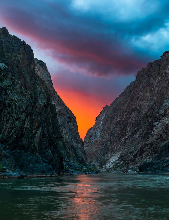
America’s Most
                 Endangered Rivers® of 2023

“This report sounds the alarm. It is a
national call to action to defend these
rivers and all of the life they support.”

                                                                                         COVER PHOTO: GRAND CANYON, ARIZONA
— Tom Kiernan, President                                                                                        AMY MARTIN

and CEO of American Rivers
                                                                                                              OHIO RIVER, OHIO
                                                                                                                 LORI COLEMAN

 Life Depends on Rivers SM.               the most threatened ecosystems on      As American Rivers marks 50 years
 Two-thirds of our water comes from       the planet. Meanwhile, climate         of conservation impact, we know we
 rivers. Rural and urban areas            change is fueling more severe floods   need to work shoulder to shoulder
 depend on rivers for clean drinking      and droughts — and unjust policies     with strong leaders and partners on
 water, food production, economic         put the burden of all these impacts    rivers all across the country. We are
 vitality, and cultural connection.       disproportionately on Communities      proud to join with partners like those
 Rivers provide natural habitat           of Color and Tribal Nations.           advocating for the future of
 indispensable to fish, birds, and        Healthy rivers are essential to        America’s Most Endangered Rivers®
 other aquatic and land animals. Like     human health and public safety.        of 2023. Together, we must defend
 the veins and arteries in our own        When rivers are sick, people and       these 10 rivers — and demand
 bodies, our health and our future are    nature suffer.                         greater protections for all 3 million
 directly linked to our rivers.                                                  miles of rivers across our country.
                                          In its 38th year, America’s Most
 But too many of our rivers are sick.     Endangered Rivers® amplifies the
 Forty-four percent of waterways in       voices of local leaders speaking up    Healthy rivers are essential to
 the United States are too polluted for   for rivers at risk. The 10 rivers on   human health and public
 fishing or swimming, according to        this year’s list underscore how
 the US Environmental Protection          health and safety are threatened by    safety. When rivers are sick,
 Agency. Freshwater species are           climate change, pollution, dams, and   people and nature suffer.
 going extinct faster than ocean or       other threats to rivers.
 land species, and rivers are among

                                                                                                                          2
8

                                             4                      5

                                                                                                                        7

                                6                                                                                 2

                                                                            9

                                                        1
                                                                                                      3           10

 1   Colorado River through the Grand Canyon, AZ ................. pg 4                             American Rivers reviews nominations for
                                                                                                    the America’s Most Endangered Rivers®
 2   Ohio River, IL, IN, KY, OH, PA, WV .................................... pg 7
                                                                                                    report from river groups and concerned
 3   Pearl River, LA, MS ............................................................. pg 9        citizens across the country. Rivers are
                                                                                                    selected based upon the following criteria:
 4   Snake River, ID, OR, WA .................................................... pg 11
                                                                                                    » A major decision that the public can
 5   Clark Fork River, MT ........................................................... pg 13            help influence in the coming year on
 6   Eel River, CA ....................................................................... pg 15      the proposed action.
                                                                                                    » The significance of the river to people
 7   Lehigh River, PA .................................................................. pg 17
                                                                                                       and nature.
 8   Chilkat and Klehini rivers, AK............................................... pg 19
                                                                                                    » The magnitude of threat to the river
 9   Rio Gallinas, NM ................................................................. pg 21          and its communities, especially in light of
                                                                                                       climate change and racial injustice.
10   Okefenokee Swamp, GA .................................................... pg 23

ABOUT AMERICAN RIVERS
American Rivers is championing a national effort to protect and restore all rivers, from remote mountain streams to urban
waterways. Healthy rivers provide people and nature with clean, abundant water and natural habitat. For 50 years,
American Rivers staff, supporters, and partners have shared a common belief: Life Depends on Rivers SM.

FOR MORE INFORMATION: A M E R I C A N R I V E R S . O R G

                                                                                                                                                     3
1
COLORADO RIVER
IN THE GRAND CANYON
THREAT: Climate change, outdated water management

STATE: Arizona

AT RISK: Ecosystem health,                                                          OHIO RIVER, OHIO
reliable water delivery, regional                                                                         PHOTO: LORI COLEMAN
economy

SUMMARY                                                                                                            SINJIN EBERLE

The Colorado River’s Grand
Canyon is one of our nation’s,         THE RIVER
and the world’s, greatest natural
treasures. A sacred place of
                                       The Colorado River flows nearly 1,500 miles from the Rocky Mountains to the sea in
deep cultural significance, it is      Mexico. Along its way, the river traverses some of the driest and hottest areas of the
also a beloved recreation and          country, providing drinking water to 40 million people, including some of the nation’s
travel destination, and home to        largest cities including Los Angeles, Phoenix, Las Vegas, and Denver, as well as 30
endangered plants and animals.         federally recognized Tribes including the Navajo, Ute, Havasupai, and many others.
But rising temperatures and severe     The Colorado River provides irrigation water for nearly six million acres of ranch and
drought driven by climate change,      farmland, including farms that grow 90 percent of this country’s winter vegetables.
combined with outdated river           The river is also the engine of a recreational economy dependent on adequate river
management and overallocation          flows and water supplies to operate. In all, the Basin feeds a $1.4 trillion economy
of limited water supplies put this     integrally connected to the broader national economy.
iconic river at serious risk. As it
makes critical decisions about water   The Grand Canyon is the iconic heart of the Colorado River. This 277-mile stretch of
management along the Colorado          river in Northern Arizona is unmatched in nature. Recognized as a World Heritage
River, the Bureau of Reclamation       Site, one of the Seven Natural Wonders of the World, and one of the most famous
must consider the environment a        landscapes on earth, the Grand Canyon is the foundation of the Colorado River
key component of public health and     Basin’s natural and cultural fabric, and the National Park draws millions of visitors
safety and prioritize the ecological   each year.
health of the Grand Canyon.
                                       The biodiversity of the Grand Canyon is astounding. From alpine meadows and
                                       soaring Douglas fir of the North Rim at over 8,000 feet to the stiff Blackbrush and
                                       fuchsia petals of the Pincushion cactus in a desert the same elevation as Tucson, the
                                       Grand Canyon is an ecological refuge. It is home to unique wildlife including bighorn
                                       sheep, mountain lion, elk, and beaver, as well as fish such as the endangered
                                       Humpback Chub and Colorado River Pikeminnow.
                                       The Grand Canyon is the lifeline between the Upper and Lower Colorado River
                                       Basins and is bookended from above and below by two massive dams, forming the
                                       two largest reservoirs in the country. The Grand Canyon National Park starts 16 miles
                                       below the tailwaters of Glen Canyon Dam located in Page, Arizona.

                                                                                                                            4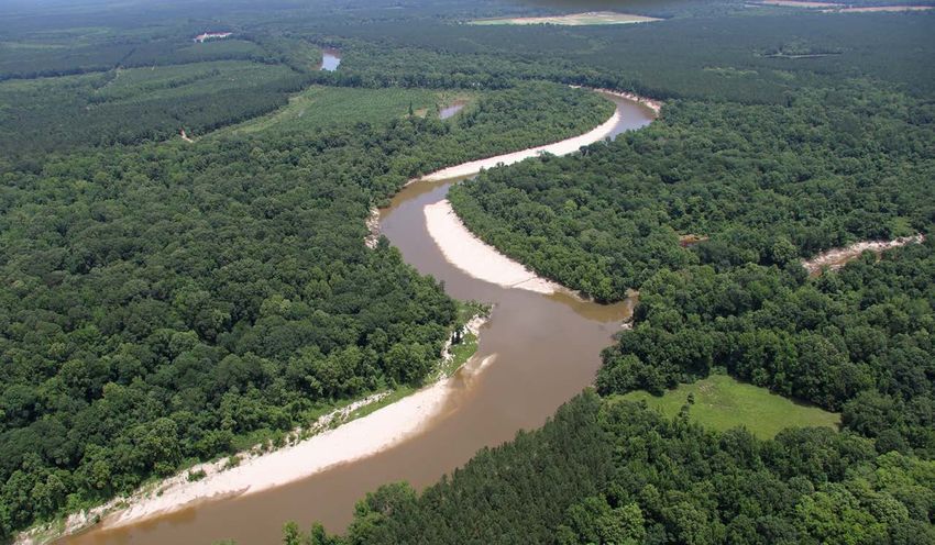
Construction on the dam was completed in 1963, and

 1                                                             waters began to back up behind the dam, flooding the
                                                               back country of Glen Canyon to create Lake Powell.
                                                               Hoover Dam in Nevada was completed in 1936 and backs

COLORADO
                                                               up water to form Lake Mead — the largest reservoir in the
                                                               US — backing up the river 65 miles at its longest reach to

RIVER IN THE
                                                               Pearce Ferry at the western end of Grand Canyon.

                                                               THE THREAT
GRAND CANYON                                                   The Colorado River is on the brink of collapse, and the
                                                               Grand Canyon is in the crosshairs as river managers
Continued                                                      make critical decisions about how to allocate dwindling
                                                               water supplies. While the river originally terminated in
                                                               Mexico’s Sea of Cortez, it has been so over-tapped since
                                                               the mid 1900s that it dries up 100 miles from its original
FOR MORE INFORMATION:
                                                               end point. Over the past 20+ years, river flows have
SINJIN EBERLE                                                  dropped precipitously, and water levels of Lake Powell
Southwest Communications Director                              and Lake Mead have fallen to historic lows, in large part
American Rivers
(720) 373-0864                              COLLEEN MINIUK
                                                               driven by climate change.
seberle@AmericanRivers.org
                                                               To protect critical infrastructure including dam integrity,
                                                               hydropower generation and the ability to deliver water
TAKE ACTION:                        through the Grand Canyon to Nevada, Arizona, California and Mexico, the federal
AMERICANRIVERS.ORG/                 government and the 7 basin states must continue to modify the amount and timing of
GRANDCANYON2023                     water allowed to flow through Glen Canyon Dam. The question before river
                                    managers is “will we attempt to solve the basin’s water challenges by sacrificing the
                                    health of the Grand Canyon, or will we pursue lasting solutions that balance water
                                    demands with environmental health and safety?”
                                    In response to more than two decades of dry years throughout the Colorado River
                                    basin, in 2022 the Bureau of Reclamation (BOR) took emergency actions to protect
                                    infrastructure at Lake Powell. Despite the prospect of an above average water year in
                                    2023, which may buy a little time for the basin, reducing water deliveries and
                                    resulting changes in flows through Glen Canyon Dam into the Grand Canyon in the
                                    coming years is inevitable.
                                    Altering flows from Glen Canyon Dam has significant impacts on the Grand Canyon.
                                    The prolonged drought and accelerating impacts from climate change triggering
                                    falling lake levels at Lake Powell has already caused significant harm to the canyon.
                                    If future flows are severely altered without consideration for the environment, it
                                    could further devastate the Grand Canyon’s irreplaceable natural, cultural, and
                                    recreational values.
                                    For many, the Grand Canyon and its surroundings are sacred. Reducing releases
                                    from the dam to turn the river into a mere trickle would not only impact native fish,
                                    plants, and wildlife, but also the health and well-being of those who are inextricably
                                    tied to this place. More than a dozen Native American Tribes and Pueblos revere the
                                    Canyon, and millions of people a year find awe, healing, and excitement by just being
                                    in and around this place. These challenges are serious threats to the health and
                                    well-being of both people and the environment, and if not solved, could do serious,
                                    lasting harm to arguably the most recognizable National Park in the country, and all
                                    people who love it.
                                    Furthermore, with the rapid and consistent decline of water elevations at Lake
                                    Powell, Colorado River flows from Glen Canyon dam are warming. That is, the
                                    warmer layer of water in the top of the reservoir’s water column has dropped to a
                                    level where that warm water is flowing through the dam’s hydropower tubes. This
                                    situation has allowed high-risk, non-native fish such as smallmouth bass to pass

                                                                                                                         5
through the dam into the Grand Canyon. Smallmouth bass

  1                                                                   are new to the Grand Canyon environment and biologists
                                                                      fear they will cause serious harm to both cold-water sport
                                                                      fish (rainbow and brown trout) and juvenile native and

COLORADO
                                                                      endangered fish such as the humpback chub. Without a
                                                                      mechanism to stop these and other types of non-native

RIVER IN THE
                                                                      fish from getting into the Grand Canyon, cold-water
                                                                      and native fish populations that have been supported
                                                                      through long-term investments of millions of dollars and
GRAND CANYON                                                          countless operational hours will once again be placed in
                                                                      serious jeopardy.
Continued
                                                                      WHAT MUST BE DONE
                                                                      We simply cannot allow the beloved Grand Canyon to
                                                                      become an ecological sacrifice zone as we work to solve
                                                                      the Colorado River basin’s ongoing water crisis. The BOR
                                                                      is currently considering two federal actions where the
                                                                      public can participate and encourage the development of
                                                                      flow regimes that will incorporate and consider ways to
                                                                      protect the ecological, cultural, and economic values of
                                                                      the Grand Canyon.
                                                                      Low flows in the river are creating a perception that we
                                                                      can no longer implement the types of flows needed to
                                                                      support environmental and natural resources in the Grand
                                                                      Canyon because there is not enough water. We can,
                                                                      however, both protect public health and safety and
                                                                      support the ecosystem by ensuring that water delivered
                                                                      through the Grand Canyon is released in a way that not
                                                                      only accounts for critical infrastructure and sustains the
                                                                      river’s essential connection to the Lower Basin States and
                                                                      Mexico, but also protects the canyon’s cultural heritage
                                                      AMY MARTIN
                                                                      and the natural environment from extinction.
                                                                   BOR is requesting public comments around a
Supplemental Environmental Impact Statement (SEIS) to temporarily amend a set of rules known as the 2007 Interim
Guidelines that could alter flows through Glen Canyon Dam in the short-term. BOR’s purpose for this action is to address the
immediate emergency to the Colorado River community’s water supply and public health and safety for the Basin. It is critical
that BOR recognize the environment as a key component of public health and safety.
The Grand Canyon’s ecological stability is at stake and must be part of the calculations for operating the Colorado River
system under the SEIS. That is, in determining the suitable range of flows to pass through Glen Canyon Dam in response to
the emergency conditions in Colorado River Basin, it will be imperative to identify and assess the critical resource needs within
the Canyon and the operational opportunities available to help sustain and improve physical conditions of the Colorado River
in Grand Canyon. Specifically, BOR should consider how it can best utilize and time the altered flow volumes from Glen
Canyon Dam to replicate natural flow dynamics through Grand Canyon.
Understanding the impacts from the range of possible flow options must be comprehensive to fully evaluate and prioritize the
tradeoffs to the array of physical, biological, and cultural values and what adaptation or resilience strategies will be needed to
protect and sustain these resources.
This future is not possible without leadership and representation of Colorado River Tribes. As sovereign nations, tribes must
have an equal role in the deployment and implementation of federal infrastructure dollars and all future Colorado River
management decisions. It is imperative that the seven Colorado River Basin states and the Biden administration establish a
way to formally engage with Tribal Nations to address this river emergency. They must act with urgency to invest and
implement equitable and proven solutions to reduce water risk in the Basin and build a stronger future centered around a
healthy Colorado River.

                                                                                                                                     6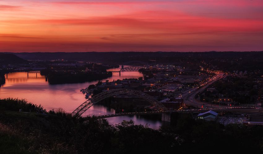
2
OHIO
RIVER
THREAT: Pollution, climate change

STATES: Pennsylvania, Ohio,
West Virginia, Kentucky, Indiana,
and Illinois
                                                                                       OHIO RIVER, OHIO
                                                                                                              PHOTO: LORI COLEMAN
AT RISK: Clean water for
over 5 million people
                                                                                                                        LORI COLEMAN

SUMMARY
The Ohio River unifies 30 million      THE RIVER
people across 15 states, from New
York to Mississippi. Protecting this
                                       The Ohio River begins at the confluence of the Allegheny and Monongahela rivers in
precious resource is essential to      Pittsburgh, Pennsylvania, flowing southwest and defining boundaries of Ohio, West
ensuring the endurance of cultural     Virginia, Kentucky, Indiana, and Illinois before flowing into the Mississippi River in
identity, historical significance,     Cairo, Illinois. The watershed covers more than 200,000 square miles and provides
biodiversity, vibrant river            drinking water for over five million people.
communities, and safe drinking
                                       The Ohio River is rich in Indigenous history and culture. The word “Ohio” comes from
water. But the upper river is
                                       the Seneca name for the river, Ohiyo, which means “it is beautiful.” Many ancestors of
threatened by industrialization and
                                       Native American descendants still living in Ohio today were forced to relocate. In
pollution, recently exemplified by
the East Palestine train derailment.   addition to Native American history, the river also holds deep significance in our
This ongoing chemical disaster         nation’s struggle for justice from an African American perspective. A sign in
underscores the vulnerability of the   Parkersburg, West Virginia reminds us that before emancipation, the Ohio River was
Ohio River and need for increased      the gateway to freedom for those enslaved south of the Ohio River. If you could cross
safeguards and durable funding         the Ohio River, you had reached freedom. The river remains a significant historic site
for additional and continuous          and a symbol of freedom.
monitoring. To protect the Ohio
                                       In addition to its cultural and historic importance, the river provides critical habitat for
River, Congress must designate
the river as a federally protected
                                       150 species of fish and the watershed protects endangered species such as the candy
water system and commit to             and diamond darter, several species of mussels, and crayfish. The rivers, streams and
significantly fund both the Ohio       lakes are a source of recreation for communities throughout the watershed.
River Restoration Plan and Ohio
River Valley Water Sanitation          THE THREAT
Commission’s technical upgrades.
                                       The Ohio River Basin drains areas affected by environmental pollution from heavy
                                       industrialization, including mining and resource extraction for energy development,
                                       chemical production, and durable goods manufacturing. This history has resulted in
                                       significant discharges of toxic chemicals, including both legacy chemicals (such as
                                       mercury, dieldrin, PCBs, and dioxins) and chemicals of emerging concern (especially
                                       PFAS and Gen-X chemicals). These discharges, with associated carbon and methane

                                                                                                                                  7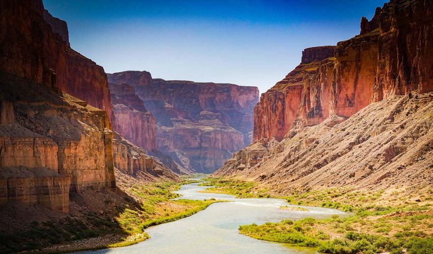
emissions, threaten human and

 2                                                                                      ecosystem health.
                                                                                        Pollution from disposal of coal ash
                                                                                        and acid mine drainage also impact

OHIO                                                                                    the watershed. Ongoing discharges
                                                                                        from industrial, municipal, and

RIVER                                                                                   agricultural sources remain a
                                                                                        challenge as a decades-long effort
                                                                                        to improve and sustain the river
Continued
                                                                                        system continue. Despite
                                                                                        measurable progress, two thirds of
                                                                                        the river is listed as impaired for
                                                                                        bacteria under the Clean Water Act.
                                                                                        High levels of nutrients present in
FOR MORE INFORMATION:                                                                   the river results in the formation of
                                                                                        toxic algae outbreaks. The
HEATHER TAYLOR-MIESLE
                                                                                        cumulative impact of all of this
American Rivers
(301) 957-1450                                                                          pollution threatens drinking water
htaylor-miesle@americanrivers.org                                BREWSTER RHOADS        and public health, while also putting
HEATHER SPROUSE                                                                         vulnerable communities at risk.
West Virginia Rivers Coalition
hsprouse@wvrivers.org
                                    One example of the continued challenges occurred on February 3, 2023 when a
                                    Norfolk Southern train carrying hazardous chemicals derailed in East Palestine, Ohio,
MELANIE HOUSTON                     16 miles from the Ohio River. This train was carrying at least five toxic chemicals. Of
Ohio Environmental Council
mhouston@theoec.org
                                    immediate concern was the vinyl chloride, a chemical used in plastic products. Fearing
                                    an uncontrolled explosion, Norfolk Southern chose to “vent” this chemical by burning
                                    the substance from 5 railcars. Additionally, butyl acrylate leaked into nearby streams
TAKE ACTION:                        that flow into the Ohio River. Soon after came reports of rashes and headaches, fish
AMERICANRIVERS.ORG/                 kills and animal deaths. Officials began tracking a plume of chemicals in the Ohio River
OHIORIVER2023                       in real time. ORSANCO, in conjunction and coordination with local and state
                                    emergency response officials and environmental agencies, stepped up to the plate to
                                    safeguard drinking water through monitoring and technical expertise. Unfortunately,
                                    ORSANCO is operating its staff and systems — including the organic detection system
                                    currently being used to navigate the East Palestine tragedy — on the same federal
                                    appropriation formula it received in 1972. Sustained increases in financial support for
                                    ORSANCO are needed to protect the communities and the environment in the Ohio
                                    River basin.

                                    WHAT MUST BE DONE
                                    This recent chemical tragedy underscores the precious value and vulnerability of the
                                    Ohio River. To protect the safety of drinking water for the 5 million people who depend
                                    on the river, ORSANCO requires robust, sustained funding to prevent disasters and
                                    pollution through immediate testing, long term monitoring, and technical expertise.
                                    Sustained funding is required for technical upgrades to their monitoring system and
                                    increases to staff capacity.
                                    The Ohio River Basin Alliance (ORBA), a multi-state effort in partnership with hundreds
                                    of stakeholders across the region, is drafting a basin-wide restoration plan. The Ohio
                                    River Restoration Plan is a collaborative effort modeled after successful restoration
                                    projects such as the Federal Great Lakes Restoration Initiative. This “blueprint”
                                    presents goals, objectives and actions for general improvements to safeguard drinking
                                    water, support the ecological well-being of the river, and invest in quality of life for
                                    communities along the river. Members of Congress from across the Ohio River
                                    watershed must support the plan to designate the Ohio River as a distinct water
                                    system worthy of substantial federal funding to support its recovery, protection, and
                                    future value.

                                                                                                                              8
3
PEARL
RIVER
THREAT: Dredging and dam construction

STATES: Louisiana, Mississippi

AT RISK: Clean drinking                                                              OHIO RIVER, OHIO
water, local and downstream                                                                                 PHOTO: LORI COLEMAN
communities, fish and
wildlife habitat
                                                                                                                 JENNIFER COULSON

SUMMARY
The Pearl River is one of the most      THE RIVER
biodiverse rivers in the U.S. and
the primary drinking water source
                                        From its headwaters on native Choctaw lands, the Pearl River flows nearly 500 miles
for Jackson, Mississippi. But this      through Mississippi and Louisiana to the Gulf of Mexico. The Pearl River provides
natural treasure is threatened by       habitat for more than 300 species of birds, fish, and wildlife, including the federally
a devastating private real estate       threatened Gulf sturgeon and ringed sawback turtle, and 125,000 acres of wetland
development scheme masquerading         and bottomland hardwood conservation lands. The Pearl supplies freshwater flows
as a flood control project. This        critical to the health of the Gulf of Mexico; the region’s oyster, crab, shrimp and
“One Lake” project would dredge         tourism industries; and hundreds of industrial and municipal users.
and dam the Pearl River to create
                                        The Pearl is the only public drinking water source for the city of Jackson, which
new waterfront property, destroying
vital fish and wildlife habitat,        includes 150,000 residents, 83 percent of whom are Black. The city has struggled for
worsening Jackson’s flooding and        decades to maintain basic water and sewer service and is currently under an
drinking water crisis, increasing       Environmental Protection Administration (EPA) consent decree to enforce established
toxic contamination, and reducing       rules and regulations due to sewage discharge violations in the billions of gallons
freshwater flows critical to the        annually. In 2022 the city’s residents were left without clean drinking water for months
region’s important seafood and          when one of the city’s two drinking water treatment plants failed.
tourism economies. The Biden
administration must stop this project   THE THREAT
and invest in environmentally-
sustainable flood relief for the        One Lake is a private real estate development scheme masquerading as a flood
predominantly Black community of        control project that threatens public health and safety, river and coastal ecosystems,
Jackson while protecting the Pearl      and regional economies. It will dredge 10-miles of the Pearl River, destroying 2,500
River and all the communities and       acres of mostly wetland habitat, disturbing eight highly contaminated toxic sites with
economies that rely on it.              no plan to protect public health, and causing a harmful rise in the river’s water
                                        temperature. A new dam will be constructed to contain the dredged 1,900-acre
                                        impoundment, and the dredged material will be used to build new waterfront property
                                        for real estate development putting more people in harm’s way.

                                                                                                                              9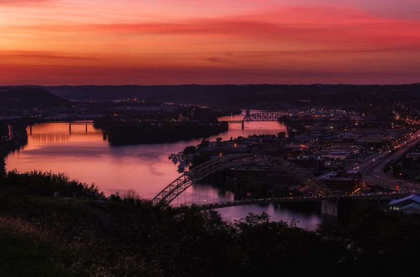
In addition to the massive loss of

 3                                                                                   floodplain, wetlands, and in-stream
                                                                                     habitats, One Lake will worsen
                                                                                     Jackson’s significant urban flash

PEARL RIVER                                                                          flooding and stormwater drainage
                                                                                     problems. One Lake will
                                                                                     permanently elevate water levels
Continued
                                                                                     in eight tributary creeks that flow
                                                                                     through primarily low-income
                                                                                     Black neighborhoods in Jackson.
FOR MORE INFORMATION:                                                                During the four years of project
OLIVIA DOROTHY                                                                       construction, Jackson will be
American Rivers                                                                      forced to somehow find an
(217) 390-3658                                                                       alternative water source for the
odorothy@americanrivers.org
                                                                                     one drinking water plant that was
JENNIFER COULSON, PH.D                                                               able to operate during the city’s
Orleans Audubon Society
(504) 717-3544                                                                       most recent drinking water crisis.
OrleansAudubon@aol.com                                                               One Lake will then add to the city’s
                                                                                     drinking water and water quality
ANDREW WHITEHURST                                              CHRIS LOCKHART
Healthy Gulf                                                                         problems, including by confining
(601) 954-7236                                                                       the rampant discharges of raw and
andrew@healthygulf.org          poorly treated sewage that has already closed the Pearl to public contact recreation
JILL MASTROTOTARO               in the Jackson area. The low-head dam will reduce and alter the delivery of
Audubon Delta                   freshwater flows and nutrients vital to a healthy river-Gulf ecosystem and the
(504) 481-3659                  communities and industries that rely on those flows.
jill.mastrototaro@audubon.org
                                Instead of subsidizing private real estate development, the federal government
LOUIE MILLER
MS Chapter of the Sierra Club
                                should invest in already identified flood relief solutions, including setting some levees
louie.miller@sierraclub.org     farther back from the river, investing in floodplain and wetland easements, targeted
                                elevations, and voluntary relocations of structures in flood-prone areas.
MELISSA SAMET
National Wildlife Federation
(415) 762-8264                  WHAT MUST BE DONE
sametm@nwf.org
                                One Lake is a federal civil works project that was rejected by the U.S. Army Corps
ABBY BRAMAN                     of Engineers multiple times in the past. This project has been revived by local
Pearl Riverkeeper               developers under a unique process that allows non-federal project sponsors to
pearlriverkeeper@gmail.com
                                study federal civil works projects. While the Army Corps is currently reviewing the
DEBRA HILL                      environmental documents developed by the private interests and has yet to decide
Lawrence County, MS             whether the project merits moving, the agency has already committed $221 million
dhill@co.lawrence.ms.us
                                from the Infrastructure Investment and Jobs Act to construct the project.
STACY ORTEGO
Louisiana Wildlife Federation
                                The incredibly destructive One Lake project will not protect communities from
(337) 351-3973                  flooding. Instead, it will result in more environmental injustice harm in metro
stacy@lawildlifefed.org         Jackson’s communities of color by worsening urban flooding, exacerbating the city’s
MAYOR MARTHA WATTS
                                long-standing drinking water crisis, and funneling critically needed investments and
Monticello, MS                  resources away from marginalized communities–all for the benefit of private real
(601) 320-0156                  estate developers.
mayor@monticello.ms.gov
                                The US Army Corps of Engineers, US Environmental Protection Agency, and US Fish
CHARLES PFEIFER                 and Wildlife Service must protect the Pearl River for people and wildlife by rejecting
Jackson Audubon Society
(504) 307-0187                  the One Lake project. These agencies should prioritize non-structural and natural
cptragopan@aol.com              infrastructure solutions to provide effective, environmentally sustainable flood relief
                                to Jackson while protecting the river’s unique ecology and wildlife.
TAKE ACTION:
AMERICANRIVERS.ORG/
PEARLRIVER2023

                                                                                                                      10
4
SNAKE
RIVER
THREAT: Four federal dams
STATES: Idaho, Oregon,
Washington
OHIO RIVER, OHIO
AT RISK: Tribal treaty rights and PHOTO: LORI COLEMAN
culture, endangered salmon runs,
rural and local communities
CARL ZOCH
SUMMARY
Salmon in the Columbia-Snake THE RIVER
River basin are on the brink of
extinction in large part due to four
The Snake River begins high in the mountains of Wyoming and flows for more than
dams on the lower Snake in eastern 1,000 miles before merging with the Columbia River at the Tri-Cities in eastern
Washington. Restoring salmon Washington. As the largest tributary of the Columbia, the Snake once produced 2-6
runs and honoring treaties and million fish annually, or 40 percent of the prized Chinook salmon and steelhead in the
responsibilities with Tribal Nations Columbia River Basin. Each year, fewer Snake River salmon complete the return trip
across the region requires removal from the ocean in what remains the longest distance, highest elevation salmon
of these four dams. Momentum migration on earth.
and support for this river restoration
Salmon are at the heart of the cultures of Northwest Tribal Nations — integral to
effort is growing, but it is critical
that the hydropower, transportation, religion, identity and physical sustenance. Historically, the region’s tribes were
and irrigation services of the wealthy people thanks in large part to a trade economy based on abundant salmon.
dams are replaced before dam Tribes have led regional salmon recovery efforts for decades. In recent years, the
removal can begin. The region’s lack of salmon has been devastating to communities across the region. Businesses
congressional delegation and the that depend upon the recreation and tourism dollars that salmon bring are suffering,
Biden administration must act with and commitments to Northwest Tribal Nations remain unfulfilled.
urgency to invest in infrastructure
so that the dams can be removed, THE THREAT
setting the Northwest on a course
to climate resilience, economic The four dams on the lower Snake River provide irrigation, transportation, and
strength, abundant salmon, and hydropower generation benefits to economies of the inland Northwest. Since
cultural revitalization. construction of the dams concluded in 1975, the four lower Snake River dams have
contributed to dramatic decreases in the basin’s salmon and steelhead populations.
All Snake Basin salmon and steelhead populations are now listed as threatened
under the Endangered Species Act.
In January 2023, the American Fisheries Society, the world’s oldest and largest
organization dedicated to strengthening the fisheries profession, advancing fisheries
science, and conserving fisheries resources, issued a position statement calling for
11the removal of the lower four
4 Snake River dams. The statement
reads in part; “(w)hen the body of
scientific evidence is considered, it
SNAKE is clear that breaching the four
lower Snake River dams is
RIVER
necessary to (1) substantially
improve the probability of
recovering these cultural and
Continued ecological keystone species to
healthy and harvestable
populations and (2) safeguard
those fishes from extinction.” It’s
clear that salmon cannot recover
FOR MORE INFORMATION: with the lower four Snake River
KYLE SMITH dams in place.
American Rivers
(541) 729-5830
The urgency of removing the lower
ksmith@americanrivers.org four Snake River dams has been
NEIL EVER OSBORNE increased by current and future
threats from climate change. The
TAKE ACTION: dams turned was once a free-
AMERICANRIVERS.ORG/ flowing river into a series of still-water reservoirs that act as a bathtub left in the sun,
SNAKERIVER2023 contributing to increased water temperatures and exacerbating climate change
through emissions of methane. Temperatures in the lower Snake now consistently
reach 70 degrees, a temperature which can be lethal for salmon and steelhead, in
July and remain high throughout summer months. Upstream from the four dams lies
some of the best cold-water fisheries habitat in the continental United States, with the
Salmon, Grande Ronde, Clearwater and other Snake tributaries projected to
represent over 65% of the nation’s coldwater fish habitat by the year 2080.
WHAT MUST BE DONE
Washington Governor Jay Inslee and Senator Patty Murray issued a report in late
2022 that showed that the services the dams provide can be replaced with new
infrastructure, and that these investments must be made before the dams can be
removed. Even the important, though modest, contributions of power to the
Northwest electrical grid can be replaced with a variety of new clean energy
resources. Nimiipuu Energy, a project led by the Nez Perce Tribe, is leading the way
in developing alternative energy resources, with the ultimate goal of producing
5,311MW of solar power- the amount BPA has stated is required to replace the power
generated by the lower four Snake River dams.
We need an action plan that identifies the additional strategies and development
needed to replace the services provided by the dams — irrigation, transportation, and
energy — with other forms of infrastructure that allow for local economies and
salmon to thrive in harmony, rather than in conflict. With Northwest Tribes leading the
way on renewable energy, Federal and Northwest State governments and agencies
should follow this lead and procure new clean energy resources and prioritize
investments in grid modernization and energy storage to set in motion this transition.
125
CLARK
FORK RIVER
THREAT: Pulp mill pollution
STATE: Montana
AT RISK: Public health, fish OHIO RIVER, OHIO
and wildlife PHOTO: LORI COLEMAN
SUMMARY
CLARK FORK COALITION
The Clark Fork is a regional
boating and angling destination
and supplies some of the richest THE RIVER
habitat in the lower 48. Throughout
European settlement and industrial
Rising out of mountains along the Continental Divide, the Clark Fork captures water
development, the Clark Fork from 28,000 miles of creeks and streams on its 320-mile journey to Lake Pend
was the backbone of large-scale Oreille. It supplies irrigation for farms and ranches throughout western Montana, and
enterprises that left a legacy of drinking water and hydropower for local communities. The river also provides food,
pollution and ecological damage. shelter, and vital pathways for wildlife and is a popular fishery, supporting westslope
Community members, advocates, cutthroat trout, threatened bull trout, and other game fish. The Confederated Salish
Tribes, and government officials and Kootenai Tribes, whose ancestral territories span the Clark Fork watershed, have
are among many who have been treaty rights to fish the river. The Clark Fork is a recreation destination for kayakers,
helping to heal the river, however, rafters, and recreational floaters and the river has become the primary driver of local
the shuttered Smurfit-Stone pulp outdoor economies.
mill threatens to reverse the gains
made. Sitting along four miles The Clark Fork River has faced a long legacy of industrial pollution, resulting in a
of the Clark Fork downstream of complex of Superfund sites in the river’s hard-working headwaters — several of
Missoula, Montana, Smurfit-Stone which have been successfully cleaned up, including the Milltown Reservoir and Dam
is poisoning the groundwater and that was removed in 2009. Cleanup work is making headway at these sites and the
river with dioxins and heavy metals. river is on the mend. The lack of action at Smurfit-Stone, however, puts these gains
These pollutants threaten fish and in jeopardy.
wildlife and put the health of tribal
subsistence fishers at risk. Through
THE THREAT
federal Superfund law, the polluters
are responsible for cleaning up In 1957, the Smurfit-Stone mill began producing pulp products on 3,200 acres
the site. adjacent to the Clark Fork. Initially, operators discharged wastewater directly into
the river causing fish kills and triggering public outcry. Later, the mill stored
wastewater in unlined settling ponds. Garbage and ash went into unlined,
unpermitted landfills perched on top of the aquifer. After the mill closed in 2010,
EPA placed Smurfit-Stone on its inventory of Superfund sites because of the high
volumes of toxic industrial chemicals.
13While the remaining mill buildings
5 are set back from the river, the
unlined sludge ponds and landfills
are located within or adjacent to
CLARK the river’s historic floodplain –
allowing dioxins, furans, and
FORK RIVER
heavy metals like manganese to
leak into the groundwater that
flows to the river. Even small
Continued amounts of these toxins can cause
reproductive and immune system
damage in fish and wildlife, and
these toxins increase as they
move up the food chain. Due to
FOR MORE INFORMATION: human health concerns, the
LISA RONALD Montana Department of Fish,
American Rivers Wildlife and Parks issued a
(406) 317-7757
warning to anglers against eating
lronald@americanrivers.org
any fish caught in the Clark Fork
CLARK FORK COALITION
KAREN KNUDSEN for 100 miles downstream of the
Executive Director
Clark Fork Coalition
mill. This legacy of pollution is in
(406) 542-0539 violation of the treaty rights held by the Confederated Salish and Kootenai Tribes
karen@clarkfork.org under the 1855 Hellgate Treaty.
Although an earthen berm separates the river from the mill, annual spring runoff and
TAKE ACTION: periodic flooding have eroded parts of the berm – which was never engineered or
AMERICANRIVERS.ORG/ licensed as a levee. Catastrophic flooding, like the Yellowstone River experienced in
CLARKFORKRIVER2023 summer 2022, threatens to fully erode the berm and wash tons of industrial pollutants
downstream. Missoula County’s floodplain regulations ban unlined ponds and
improperly engineered flood control structures.
For more than a decade, the EPA has failed to adequately address these threats,
and the polluters continue to resist taking responsibility for sufficient pollution
testing and cleanup.
WHAT MUST BE DONE
The EPA must compel the polluters, whose companies have morphed into
International Paper and Westrock, to eliminate the site’s immediate risk of
catastrophic flooding and its ongoing release of contaminants that pollute the
Clark Fork River. The place to start is by cleaning up approximately 140 acres of
toxic soil and industrial waste in the unlined sludge ponds and landfills near the
Clark Fork River. The EPA has authority through the Superfund process to order
cleanup actions on part of a site to reduce immediate risks to human health and the
environment while continuing to investigate pollution problems elsewhere at the site.
In addition to cleaning up the portion of the property that most threatens the Clark
Fork River and downstream communities, the EPA must compel the polluters to
undertake additional groundwater, soil, and wildlife exposure testing to better
understand sources and pathways of contamination. The EPA must compel
completion of tests the Missoula Water Quality District recommended in 2022.
146
EEL
RIVER
THREAT: Dams
STATE: California
AT RISK: Fish and wildlife; tribal OHIO RIVER, OHIO
culture and sustenance PHOTO: LORI COLEMAN
SUMMARY
M I C H A E L W I E R , C A LT R O U T
The Eel River once teemed with
abundant native fish and other
wildlife, supporting the Wiyot, THE RIVER
Sinkyone, Lassik, Nongatl, Yuki
and Wailaki peoples who have
The Eel River is the ancestral home of tribal groups including the Wiyot, Sinkyone,
lived along the river since time Lassik, Nongatl, Yuki and Wailaki peoples, and also now the home of other Tribes
immemorial. Today the river’s that were forcibly moved to the area in the early 20th Century. Many of these people
Chinook salmon, steelhead, and continue to live along and care for the river today.
Pacific lamprey are all headed The river is the third largest in California, with an area of 3,684 square miles. The
toward extinction in large part
mainstem Eel River’s headwaters are located in the Snow Mountain Wilderness in
because of two obsolete dams
Mendocino National Forest, where cold waters provide an ideal refuge for native fish
that make up Pacific Gas &
as the climate warms.
Electric’s (PG&E’s) Potter Valley
Hydroelectric Project. Together The Eel River was historically one of the most productive fisheries in the state,
the dams completely block salmon supporting a diverse array of native species, including four anadromous salmonid
migration and harm river habitat. species (Chinook and coho salmon, steelhead-rainbow trout, and coastal cutthroat
The license for the dams recently trout), two sturgeon species, and three lamprey species. The construction of
expired and PG&E no longer wants Cape Horn Dam in 1908 and Scott Dam in 1922 have severely impacted fisheries
to operate the facilities. Moreover,
in the river.
in a March 16, 2023 press release,
PG&E indicated that Scott Dam’s
seismic risks would result in a THE THREAT
20,000 acre foot reduction in the Two obsolete and unsafe dams on the Eel River, Scott and Cape Horn (part of the
project’s reservoir capacity. It’s up to Potter Valley Hydroelectric Project), are preventing recovery of critically endangered
federal regulators to require PG&E salmonids, including federally protected Chinook salmon and steelhead trout. The
to remove the dams as part of the
dams completely block access to high-quality habitat in the upper watershed for
decommissioning plan, expected
these fish and also prevent sediment from moving through the system, leading to
during the Fall of 2023.
habitat loss in the Eel River watershed. Once-prolific fish populations are no longer
able to access 89 miles of Chinook salmon spawning habitat and 288 miles of
steelhead habitat.
15The high elevation and cool
6 headwaters above the dams are
critical to the recovery of these
native fish in an era of climate
EEL change and are especially
important to rare summer
RIVER
steelhead, which are listed as
endangered under California’s
Endangered Species Act. Studies
Continued have shown that resident trout
living above the dams still carry
the genes for ocean migration,
suggesting that once the dams are
removed those fish may once
FOR MORE INFORMATION: again return to their ancestral
MEGHAN A. QUINN spawning grounds. Scott and
American Rivers Cape Horn Dams have caused
(530) 539-5530
immense harm to the Eel River
mquinn@americanrivers.org
M I C H A E L W I E R , C A LT R O U T
ecosystem and the communities
CHARLIE SCHNEIDER that depend on a healthy Eel River
California Trout, Inc.
(707) 217-0409
watershed. The dams adversely
cschneider@caltrout.org impact Tribal Nations and Indigenous people for whom the Eel River holds cultural
significance and who rely on it for sustenance. Loss of culturally and economically
ALICIA HAMANN
Friends of the Eel River
important fish runs, habitat loss and deterioration, and reductions in water quantity
(707) 798-6345 and quality are some of the negative impacts caused by the dams. Additionally, the
alicia@eelriver.org way the dams are managed causes fish to struggle at key moments in their life cycle
due to low water flows associated with out of basin diversions, inhospitable water
TAKE ACTION: temperatures caused by the reservoirs, water quality degradation including toxic
algae outbreaks, excessive predation at a poorly designed fishway, and the
AMERICANRIVERS.ORG/
proliferation of invasive species. In addition, PG&E recently admitted that Scott Dam,
EELRIVER2023
which impounds the Lake Pillsbury reservoir, presents unacceptable seismic risk
when the reservoir is at full capacity.
WHAT MUST BE DONE
PG&E’s decision to surrender their license to operate the dams and decommission
the project is an enormous opportunity to remove obsolete unsafe dams that
endanger downstream communities, facilitate salmon recovery, restore cultural
connections, revitalize an important commercial and recreational fishery, and
reconnect what would be California’s longest free flowing river.
PG&E must expedite the next step towards restoring this river and its communities by
removing both dams, repairing the damage they have caused, and ensuring the
safety of downstream communities. They must also take immediate steps to reduce
the impacts to already struggling fish populations caused by the current operation of
the dams. If PG&E isn’t willing to do this on their own, the federal agency that
oversees hydropower dams, the Federal Energy & Regulatory Commission (FERC),
should hold PG&E to account and require the full removal of Scott and Cape Horn
dams as a component of decommissioning. PG&E cannot be allowed to walk away
from these obsolete dams leaving a liability in place for current and future
generations to contend with.
167
LEHIGH
RIVER
THREAT: Poorly planned development
STATE: Pennsylvania
AT RISK: Clean water, fish and OHIO RIVER, OHIO
wildlife habitat, rural and local PHOTO: LORI COLEMAN
communities, open space
SUMMARY : TOM STORM
The Lehigh River, flowing out of the
Appalachian Mountains and through THE RIVER
the densely populated Lehigh
Valley region, is the “backyard
From its headwaters in the boreal forests of the Pocono Plateau, the Lehigh River
river” for half a million people, flows 109 miles to its confluence with the Delaware River in Easton, Pennsylvania.
and the keystone to Northeastern The river valley is the homeland of the Lenape people and includes present-day
Pennsylvania’s outdoor recreation cities of Allentown and Bethlehem.
industry. The areas that surround Part of the Lehigh River is designated as one of Pennsylvania’s Scenic Rivers, and
the river offer outdoor gathering
the headwaters are designated as Exceptional Value. The river’s name comes from
spaces and accessible recreation
the Lenape name for the river, Lechewuekink, which means “where there are forks”.
opportunities for people throughout
the watershed, but especially in The Lehigh is a whitewater river, and both new and experienced boaters enjoy its
the cities of Allentown, Easton, rapids. The river connects rural and urban communities, is a direct drinking water
and Bethlehem. But as the region source for hundreds of thousands of people, and as a tributary to the Delaware River,
becomes the logistics hub of the supports the drinking water supply of 15 million. Located in a region that has grown
eastern seaboard, with over four and contracted alongside the resource extraction industry, tourism to the Lehigh
square miles of warehouses and River has helped restore the region’s economies after the transition away from coal,
distribution centers built to date,
timber, and steel.
the river’s health is at risk. Unless
federal, state and local decision
makers act to improve protections THE THREAT
for local waterways, the area’s clean The region has become the logistics hub of the eastern seaboard, with warehouses
water and wildlife habitat could and logistics centers already covering more than four square miles of land within the
suffer irreversible harm. watershed. According to the Lehigh Valley Planning Commission, there’s another
square mile (approximately) of development in the pipeline. Currently, only California’s
Inland Empire can compare to the buildout happening in the Lehigh Valley.
Poorly planned, large-scale warehouse and distribution center development
threatens the Lehigh River by converting critical forest and wetlands to hard
surfaces—roofs and parking lots. These impervious surfaces prevent rainwater from
soaking into the ground. Instead, warm, salty, dirty water runs off the pavement
17directly into the river and its
7 tributaries. These impacts to
water quality, and the paving of
the remaining open space in the
LEHIGH urban stretches in the Lehigh
Valley, disproportionately impact
RIVER
downstream communities that
have already borne the brunt of
environmental degradation
Continued and pollution.
This development also accelerates
the impacts of climate change.
Based on calculations in a recent
FOR MORE INFORMATION: economic benefit report from Our
Pocono Waters, that acceleration
LIA MASTROPOLO will be costly. Watershed
American Rivers
(717) 763-0743
ecosystems provide numerous
lmastropolo@americanrivers.org services, like water purification, air
PHOTO: MICHAEL DONLIN
filtration, carbon storage, nutrient
DONNA KOHUT
PennFuture cycling, soil formation, erosion
(507) 778-3979 control, food, and recreational
kohut@pennfuture.org value. In the Delaware River Basin, riparian buffers provide about $11,000 per acre
through these services and $9,000 of carbon storage benefits per acre per year.
TAKE ACTION: The continued destruction of these buffers will increase carbon emissions and
the severity of flooding, and it will be costly for communities to replace the
AMERICANRIVERS.ORG/
services provided.
LEHIGHRIVER2023
Better planning and development regulations could help reduce the economic and
environmental impacts of development, but many local governments feel powerless.
Communities throughout the region have voiced concerns, but their capacity is
limited in the face of laws that fail to protect communities and the environment.
WHAT MUST BE DONE
The public can demand federal and state government decision-makers make crucial
funding and legislative decisions to protect water quality from land development
throughout the watershed.
Both the federal and state governments must provide their full, fair share of funding
to the Delaware River Basin Commission (DRBC). This regulatory agency oversees
a multi-state approach to water resource management that includes the Delaware
River and its tributaries, including the Lehigh River. Its programs address water
quality protections, flow management, and recreation, which is challenging to do
when chronically underfunded since 2014.
The Pennsylvania state legislature must pass what’s been known as the Riparian
Buffer Protection Act (previously known as HB 714). This bill would ensure that all
waterways across the state are guaranteed critical protective riparian buffers of at
least 100 feet. High Quality and Exceptional Value waterways would be provided
300-foot buffers, which would be an increase from the current 150 foot requirement.
Impaired waters would receive additional protection, as well, of 150 feet.
188
CHILKAT AND
KLEHINI RIVERS
THREAT: Mining
STATE: Alaska
AT RISK: Bald eagle, fish, and
wildlife habitat, Tribal culture and
sustenance
OHIO RIVER, OHIO
PHOTO: LORI COLEMAN
SUMMARY
Every year, hundreds of thousands
of salmon swim from the Pacific DEREK POINSETTE
Ocean into the Jilḵáat Aani Ḵa
Héeni (Chilkat River watershed) to
spawn. Alaska Natives and other THE RIVER
communities depend upon the river
and its abundance for their culture
The Klehini River is a main tributary to the Chilkat River. Together, the two rivers flow
and livelihood. But the Palmer through the Alaska Chilkat Bald Eagle Preserve, critical habitat for the largest
Project, a proposed copper and zinc congregation of eagles in the world. The watershed also supports five species of wild
mine, is about to move to the next salmon and a large brown bear population. Additionally, the ancient Tlingit Village of
stage of development that could Klukwan, ancestral and current home of the Chilkat Tlingits, and the town of Haines,
result in the release of hundreds
just downstream from the project, are totally dependent on these healthy and
of thousands of gallons per day of
toxic wastewater, contaminating productive waters for their food, economy, and culture. The land being developed by
nearby creeks that feed directly the mining consortium is currently controlled by the State of Alaska and the U.S.
into the Chilkat and Klehini rivers government, but it has been Tlingit land for thousands of years and was never ceded
and crippling the entire ecosystem to the State or federal government.
of the Chilkat Valley. This is in
addition to the already concerning
impacts of climate change, such as THE THREAT
rapid glacier melting and a historic The ongoing development of the Palmer Project is being pursued by a Canadian and
increase of rainfall. Congress
Japanese consortium: American Pacific Mining and Dowa Mining and Metals. The
and the Environmental Protection
Agency (EPA) must act now to next stage of development for the project is slated for the summer of 2023. The
ensure the fundamental protections developers want to dig a mile-long “exploratory” tunnel under the Saksaia Glacier,
guaranteed by the federal Clean directly above the Klehini River. The excavation will create huge waste storage piles
Water Act are not abandoned and and contaminated wastewater discharges in an area with extremely high levels of
a grave environmental injustice is sulfide deposits, rainfall, snowfall, and seismic activity. The acidic wastewater,
not allowed. EPA must intercede
contaminated with heavy metals, hydrocarbons from vehicles and drilling muds, and
immediately and direct the mining
consortium to apply for a standard explosive residues, will flow into the nearby creeks and the Chilkat and Klehini rivers.
surface water discharge permit that This development is extremely dangerous to the fragile ecosystem of the
will require meeting all applicable Chilkat Valley.
State and federal Water Quality
Standards. Mining industry supporters claim the demand for more electric cars is justification for
mining copper wherever it can be found, ignoring the potential for reclaiming copper
through recycling, as well as acknowledging the recklessness of mining new deposits
19located in critical salmon habitat,
8 especially habitat with the
worldwide ecological significance
of the nearby Alaska Chilkat Bald
CHILKAT AND Eagle Preserve.
Congress and the EPA have the
KLEHINI RIVERS ability to ensure that the Clean
Water Act is enforced. Public
support could also play a
Continued
significant role in convincing the
federal government to allow
co-management of the area by the
Tribal Council of the Village of
FOR MORE INFORMATION: Klukwan, whose people have been
DAVID MORYC living in, and protecting this
American Rivers ecosystem for thousands of years.
(503) 307-1137
dmoryc@americanrivers.org WHAT MUST BE DONE
GERSHON COHEN ANDY HEDDEN Congress and the EPA must act
ACWA (Alaska Clean Water Advocacy)
(907) 314-0028 now to ensure the fundamental
gershon@aptalaska.net protections guaranteed by the federal Clean Water Act are not abandoned
and a grave environmental injustice is not allowed. EPA must intercede
immediately and direct the mining consortium to apply for a standard surface
TAKE ACTION:
water discharge permit that will require meeting all applicable State and
AMERICANRIVERS.ORG/ federal Water Quality Standards.
C H I L K AT R I V E R 2 0 2 3
209
RIO
GALLINAS
THREAT: Climate change, outdated
forest and watershed management
STATE: New Mexico
AT RISK: Clean drinking water, OHIO RIVER, OHIO
farming, watershed functionality PHOTO: LORI COLEMAN
SUMMARY
J A C O B E R I C K S O N , H P WA P R D I R E C TO R
New Mexico’s waterways are
among the most vulnerable in the
United States. The Rio Gallinas THE RIVER
is the poster child for the adverse
impacts — both ecological and
The Rio Gallinas, flowing from the east side of the Sangre de Cristo Mountains, is a
cultural — of climate change critical tributary to the Pecos River. Approximately 13,000 people depend on the Rio
on Southwestern watersheds. Gallinas for drinking water. Traditional Hispanic acequia systems, with a 500-year
The river provides water for Las history on the landscape, also depend on the river to sustain agricultural and
Vegas, New Mexico, and for the ranching communities. A large amount of the river is diverted to Storrie Lake to meet
traditional acequia irrigation system. the needs of the Storrie Project Water Users Association. The Rio Gallinas watershed
Drinking water, farming, and is home to a rich and diverse array of wildlife, including threatened and endangered
overall watershed functionality are species. The watershed and river also support many recreational activities such as
all threatened by climate change hunting, fishing, and hiking.
and outdated forest management
practices. Furthermore, without a
good connection to its floodplain
THE THREAT
and a loss of wetlands, the Rio Over 20 years of drought, reduced snowpack, declining riparian health, high-intensity
Gallinas is less able to naturally wildfire, and increased human demands are threatening the existence of the Rio
store the water needed to maintain Gallinas. A long history of land uses that have channelized and degraded the river
flows during periods of drought. and its riparian area have made them less resilient to climate change. Infrastructure
In the aftermath of the largest fire in (e.g., homes, roads) located in the river’s floodplain further limits the ability of the Rio
New Mexico’s history, the multiple Gallinas to mitigate floods and fire. Most pressingly, outdated agency policy and
state and federal agencies charged protocols on forest management, prescribed burning, and watershed management
with managing the Rio Gallinas pose threats to local drinking water, traditional acequia agriculture, and the forest
watershed will determine the river’s products economy.
fate. It’s essential that their work
includes local communities’ input The Hermit’s Peak/Calf Canyon fire, a catastrophic wildfire event in Spring 2022, was
and updated forest management started by two USFS-prescribed burns that merged and became the largest wildfire in
protocols. New Mexico history. The fire devastated 341,735 acres and the majority of the upper
Rio Gallinas watershed. Over 900 structures were destroyed, including over 300
homes. The fire and ensuing floods contaminated water sources watershed-wide,
including the Rio Gallinas. Pollution of wells and the town’s reservoir caused drinking
21You can also read