Application for International Dark Sky Sanctuary Designation
←
→
Page content transcription
If your browser does not render page correctly, please read the page content below
“We Have Dark Skies and We Are Going to Keep Them!”

      Application for
  International Dark Sky
   Sanctuary Designation
Beaver Island Association & Beaver Island Chamber of Commerce

Beaver Island Dark Sky Sanctuary

             “There is more to dark skies than just looking at
               astronomical objects through a telescope. “
                           ~ Brian Vaeth, 2020
Contents
Introduction .................................................................................................................................... 1
   More about the Beaver Islands State Wildlife Research Area .................................................... 4
   Access to the Beaver Island Dark Sky Sanctuary ......................................................................... 4
The Certification Zone in Detail ...................................................................................................... 7
   Beaver Islands State Wildlife Research Area .............................................................................. 7
      Management Plan for State-owned Lands on Northern Lake Michigan Islands..................... 9
   Charlevoix County Beaver Head Light Park ............................................................................... 14
   Central Michigan University Miller’s Marsh Research Area ..................................................... 15
IDA Sanctuary Definition, Eligibility and Requirement Statements ............................................. 16
   Definition of an IDA International Dark Sky Sanctuary ............................................................. 16
   Eligibility for All Sanctuaries – BIDSS Statements ..................................................................... 16
   Minimum Requirements for All Sanctuaries – BIDSS Statements ............................................ 17
   Night Sky Preservation Guidance .............................................................................................. 19
Protection for Scientific, Natural, Educational, Cultural, and Public Enjoyment Values.............. 22
   Scientific .................................................................................................................................... 22
      Central Michigan University Biological Station ..................................................................... 22
      Nature Conservancy and Little Traverse Conservancy .......................................................... 23
   Statement of Mission from the Wildlife Division of the Michigan DNR ................................... 23
Cultural Values .............................................................................................................................. 24
      Teach your children well........................................................................................................ 25
      Anishinaabek Constellations.................................................................................................. 27
Public Enjoyment Values............................................................................................................... 27
   Dark Sky Interpretation and Education ..................................................................................... 27
BIDSS Night Sky Quality Sky Quality Meter (SQM -L) Readings .................................................... 30
   Threats to Dark Skies ................................................................................................................. 33
Light Inventory .............................................................................................................................. 34
   Lighting Management Plan ....................................................................................................... 34
International Dark Sky Sanctuary Nomination and Support Letters ............................................ 39
Educational/Interpretational/Media-related Examples ............................................................... 57
   Radio and other Media Promotions.......................................................................................... 61
   Raising Awareness through Event Promotion .......................................................................... 63

                                                                                                    ii | B I D S S A p p l i c a t i o n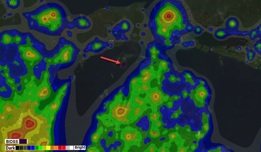
Public Outreach............................................................................................................................. 64
   Past Events ................................................................................................................................ 64
   Statewide Promotion ................................................................................................................ 65
   Future Outreach ........................................................................................................................ 65
   Other Media .............................................................................................................................. 67
References .................................................................................................................................... 68
Dedication ..................................................................................................................................... 69

Author and Project Manager Contact Information
Cynthia Johnson, Beaver Island Dark Sky Project Leader
Beaver Island Association & Beaver Island Chamber of Commerce
P.O. Box 295, Beaver Island, MI 49782 Ph: 231-350-8792
Email:cynthia.johnson@darkskyisland.org
Data collection credits: William Markey, Sky Quality Meter Readings
Images: Frank Solle, Cynthia Johnson, Libby Henderson, Taffy Raphael
Special Thanks: Beaver Island Dark Sky Committee and the Beaver Island Association

                                                                                                  iii | B I D S S A p p l i c a t i o n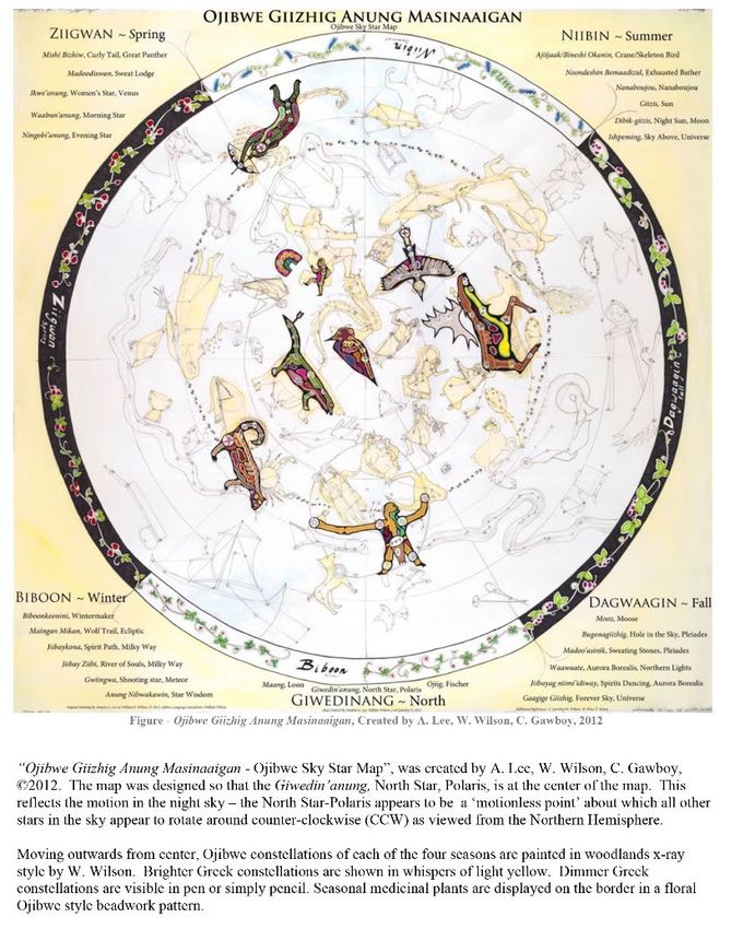
Introduction
Beaver Island is the largest island in the Beaver Island Archipelago in Northern Lake Michigan.
The proposed Dark Sky Sanctuary, located at the southern least populated area of the island, is
made up of (i) portions of the Beaver Island State Wildlife Research Area that include limited
access roads and trails, (ii) adjacent land owned by the County of Charlevoix that includes a
historic lighthouse and fog signal station as well as rustic camping facilities and (iii) an adjacent
research area owned by Central Michigan University that includes a marsh and hiking trails.
This isolated location features an unimpeded deep and dark night sky along with many other
unique features due to location and conservation efforts. Night sky quality is illustrated and
documented in this application with broad spectrum night sky photography, SQM readings, and
statements of support by expert star gazers, astro-photographers and telescope buffs.
When observing in Beaver Island's dark sky landscape, viewers are gifted with deep and vast
views of constellations, galaxies, nebulae, and the Milky Way, and with the phases of the moon
and the cycles of the planets; the Island provides excellent views of meteor showers, Northern
Lights, the occasional comet, and rare Zodiacal light. Members of the original Beaver Island
Astronomical Society, now the Beaver Island Dark Sky Project, have recorded SQM readings at
multiple Island-wide viewing areas including inside the proposed Sanctuary ranging to 21.86
and averaging 21.75 on the magnitudes per arcsecond squared scale. Even the skies above the
Harbor lights downtown hold a dark sky background of the Universe.
Beaver Island is in Lake Michigan in the U.S. state of Michigan. It is the only inhabited island in
the Beaver Island Archipelago
(pictured at left in Figure 1 with the
proposed sanctuary area shown in
red). At 55.8 sq mi (145 km2), it is
the largest island in Lake Michigan
and the third largest island in the
state of Michigan. The island is
located approximately 32 miles (51
km) from the city of Charlevoix.
Beaver Island had a total
population of 657 at the 2010
census. Travel to the island is only
possible via plane or boat. These
means of travel can be abruptly
halted due to snow, wind/ gales
and ice. Inaccessibility has
historically kept the island sparsely
populated, isolated and far from        Figure 1: Beaver Island Dark Sky Sanctuary Location Map (Google Maps)

any civilization marred by
illumination. Even in the age of advanced technology, Beaver Island has remained free of

                                                                          1|BIDSS Application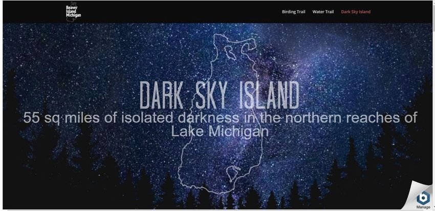
pollution except for nominal sky glow from the mainland, red and green lake channel markers
and two airport beams.
The isolated circumstances of the island attract residents and visitors that are generally intent
on preserving and enjoying its multiple natural resources. The island hosts a broad variety of
eco-systems representative of those found in the great lakes areas and, as a result, a large
portion of land is reserved for research purposes. The archipelago is designated as an
Important Birding Area, providing important nesting habitat for colonial waterbirds, and is
recognized for its significance to Neo-arctic-Neotropical migrants as a critical stop over,
refueling, and as nesting habitats which are important to the bird conservation. The
community recognizes that Beaver Island is a fragile ecosystem demanding constant vigilance in
protection measures against invasive species, erosion and now at the top of the list, harmful
light pollution that could damage our wild and human life.
The Beaver Island Dark Sky Sanctuary is a uniquely isolated location that also enjoys the support
infrastructure of a vacation destination. The Dark Sky Sites map below (Figure 2) shows its
location and ideal viewing conditions. Notably, the skies on the island are several degrees
darker than those in the nearby Headlands Dark Sky Park, which is recognized by the IDA.

                Figure 2: Dark Site Finder Location Map Overlay (darksitefinder.com)

                                                                   2|BIDSS Application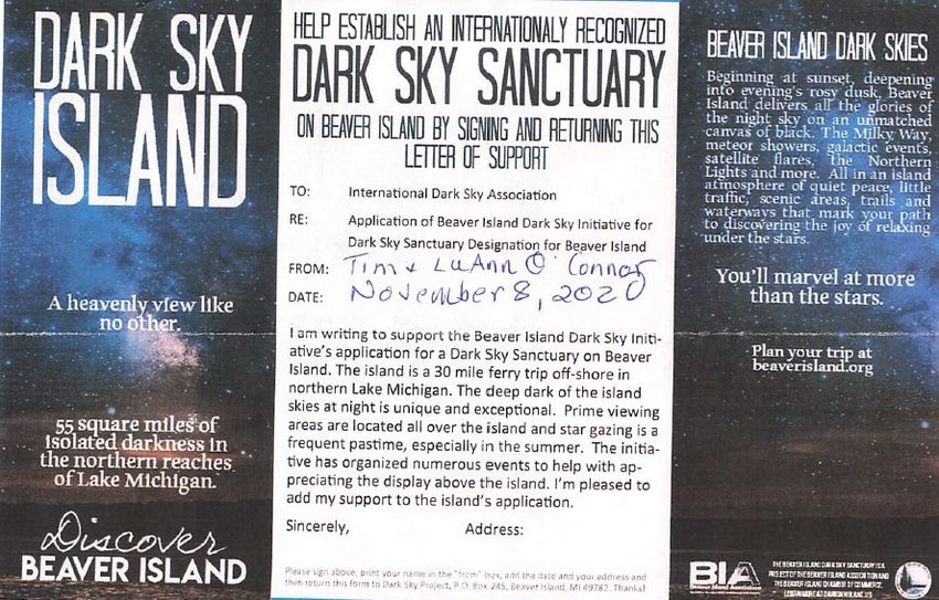
While the island is uniquely dark and remote, it is within easy travel distance in the Midwest.
Nearby mainland airports with commercial service from international carriers include Cherry
Capital Airport in Traverse City (about an hour drive south from Charlevoix) and Pellston
Regional Airport (about a 45 minute drive north). Indeed, as the next map (Figure 3) shows, it is
difficult to find an accessible location with darker skies in the whole of the eastern United
States.

                 Figure 3:Dark Site Finder Map of Eastern U.S. (darksitefinder.com)

                                                                   3|BIDSS Application
More about the Beaver Islands State Wildlife Research Area
The bulk of the Beaver Island Dark Sky
Sanctuary lies within the southeastern
boundaries of the Beaver Islands State Wildlife
Research Area, a networked set of insular
properties of the U.S. state of Michigan. This
section of the Research Area is approximately
12,000 acres in size. The entire research area is
shown shaded in green in the adjacent map. It
is overseen by the Michigan Department of
Natural Resources, Wildlife Division in Gaylord,
Michigan and, as is discussed in greater detail
elsewhere in the application, the DNR generally
manages the research area in accordance with
its name—as wilderness. Structures, roads and
other improvements beyond those in place are
prohibited. There is no artificial lighting, and
the management plan does not allow for it.
The Research Area includes other land on the
island as well as the outlying islands in the
archipelago. While the Beaver Island Dark Sky Sanctuary includes only those contiguous lands
shown in the Beaver Island Dark Sky Sanctuary map (and not the entire Wildlife Research Area,
it is important to note that the presence of those areas adjacent to the sanctuary area will help
preserve its dark sky status (because of the strict limitations on development on those lands). In
addition to the Wildlife Research areas, adjacent properties also include additional public lands
that are protected from developments as well as private lands that are subject to conservation
easements that limit development.

             Signage from the Little Traverse Conservancy shows adjacent private lands
                          being conserved and protected by that agency.

Access to the Beaver Island Dark Sky Sanctuary
To reach the BIDSS, go five miles south of the town of St. James, in Peaine Township, on East
Side Drive or King’s Highway, the one paved road on the island. King’s Highway turns to gravel
and several sections of the sanctuary are accessible by unmarked footpaths. At the end of

                                                                  4|BIDSS Application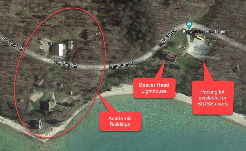
King’s Highway at Hannigan’s Road is a marked Birding Trail to enter. Along Hannigan’s Road to
the East and West are footpaths or two track drives interspersed between private property and
state land for entrance. There are Seasonal Road, Birding Trail or Walking Trail signs to indicate
entry points. Signs indicating the boundary of the sanctuary will be added to this signage. From
the shoreline, the Beaver Island Water Trail Signage leads visitors onto the island near trails to
access the sanctuary. Access points are also found on the Beaver Island Bike Trail.

              Beaver Island Birding Trail Signage is consistently dispersed throughout
             the sanctuary denoting access and entrance. BIDSS signage will be added.

The sanctuary is easily accessible at Bill Wagner Memorial Campground on East Side Drive. The
22-site campground is owned by the state with reservations available via Peaine Township.
Situated on the beach, this location offers views to the North, direct West and south.
The recommended and featured dark sky viewing areas inside the proposed Beaver Island Dark
Sky Sanctuary are both easily accessible from the West Side Road. The Big Field, as it's
traditionally called, is just north of Miller's Marsh and a quarter mile from the main road with
its own two-track entrance. The Camp #3 viewing area is a mile and a half south of the West
Side Road - Camp #3 Trail intersection with many views of the sky and multiple viewing areas.
Both have zero light sources and no horizon light domes to interfere with any dark sky
application from eyeball astronomy to astrophotography. Appropriate signage and directions
will be put in place after receiving Sanctuary designation.
Below Hannigan’s Road on the West Side is a seasonal road leading into the sanctuary, as well
as many other seasonal roads around the sanctuary. The Birding Trail map above is clearly
marked and many of these lead into the sanctuary. A good portion of the sanctuary simply has
no marked paths and one can wander in and out of the state land as designated and governed
by the DNR Wildlife division.

                                                                  5|BIDSS Application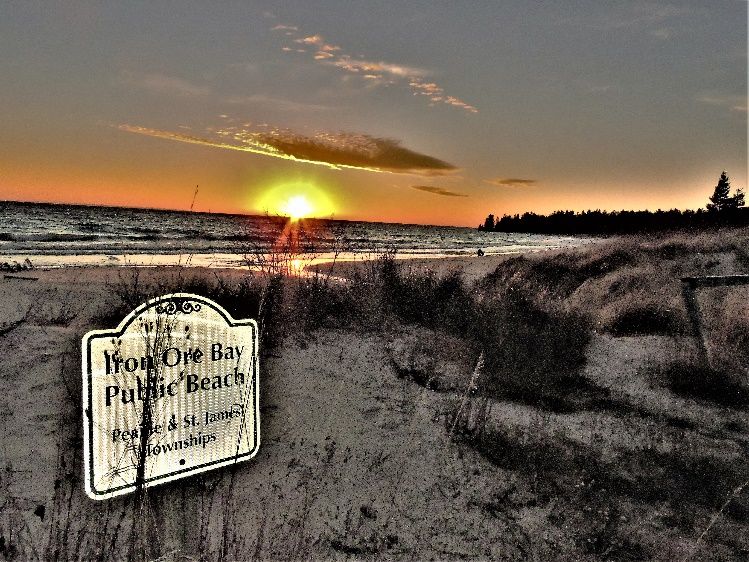
Figure 4: Beaver Island Birding Trail Map

                                      6|BIDSS Application
The Certification Zone in Detail
The proposed area for certification as the Beaver Island Dark Sky Sanctuary (“BIDSS”) includes
contiguous lands that are part of (i) the Beaver Islands State Wildlife Research Area (“State
Wildlife Research Area” or “SWRA”), (ii) the Charlevoix County Beaver Head Light Park
(“Beaver Head Light Park” or “BHLP”) and (iii) the Central Michigan University Miller’s Marsh
Research Area (“Miller’s Marsh”).

Beaver Islands State Wildlife Research Area
The State Wildlife Research Area 1 is primarily made up of lands that were either never patented
for settlement or were logged off and then allowed to revert to the state of Michigan in lieu of
unpaid property taxes. Approximately 55% of the Research Area by land extent (12,734 acres) is
located on the largest of the islands, Beaver Island. The remaining lands of the Research Area
are distributed among the other islands of northern Lake Michigan. The Research Area
cooperates with a federal unit, the Michigan Islands National Wildlife Refuge.
The Research Area is a place for the study of shoreline animal, bird, and plant life. The Michigan
DNR manages the northern four islands of the Research area, located in Charlevoix County,
from a full-time staffed office in Gaylord, Michigan. The proposed Beaver Island Dark Sky
Sanctuary resides under the management of this office.
The Research Area hosts field studies on biology and ecology. The area has been and continues
to be altered by human life and use. Hunting, fishing, boating, and camping are allowed subject
to state laws and regulations.

1
 The US Geological Survey description of the SWRA is available at tis link: https://www.topoquest.com/place-
detail.php?id=1625039

                                                                            7|BIDSS Application
Figure 5: Land Use Plan from Beaver Island Master Plan
8|BIDSS ApplicationManagement Plan for State-owned Lands on Northern Lake Michigan Islands
Beaver Island is the largest island in this group, and the most biologically diverse (biodiversity
score of 273, Henson et al. 2010). There are approximately 12,400 acres of state-owned land on
the island, or about one-third of the island, mostly located on the southern half of the island. It
is the only island with state ownership considered in this plan where DNR forest inventory has
been conducted. Major cover types on state land include northern hardwoods, lowland
deciduous forest, and lowland coniferous forests.
In addition, natural features surveys have identified numerous occurrences of threatened and
endangered species on the island (including designated critical habitat for piping plovers,
Federal Register 2001: 22938) and several high-quality natural communities (from all
ownerships), including open dunes, boreal forest, dry-mesic northern forest, mesic northern
forest, bog and poor fen. Descriptions of these high-quality natural communities can be found
in Cohen et al. (2015).
Beaver and the other islands in the group are significant from a cultural perspective because of
the history of indigenous peoples here. The oral tradition of the Odawa, who have resided on
the island for 350 years, says Native Americans began passing the islands 2,200 years ago, and
there is archaeological evidence of this presence. As is discussed later in this application, he
traditions of the Odawa and other indigenous peoples in the area respected the balance of
nature and stewardship of resources.
Beaver Island is the only island considered in this plan with scheduled commercial ferry and
airline service (two airports), and year-round residents Important management matters on
state lands, among others, include administration of an existing gravel pit, public access sites at
Lake Geneserath, Greene's Lake, and Bonner’s Landing, infrastructure at Martin’s Bluff,
historical and cultural sites like old homesteads and “Mormon fields,” hiking trails, old well
sites, bald eagle nesting territories, and Federally-designated Piping Plover critical habitat. See
Federal Register 2001: 22938.
Several land conservancy agencies and individual property owners listed below have
coordinated efforts to preserve and manage numerous sites on the island for use by the public
as natural, protected areas.
9|BIDSS ApplicationFigure 6: NLMIC Land Use Planning Map
10 | B I D S S A p p l i c a t i o nFigure 7: Recreational Facilities Map from Beaver Island Master Plan
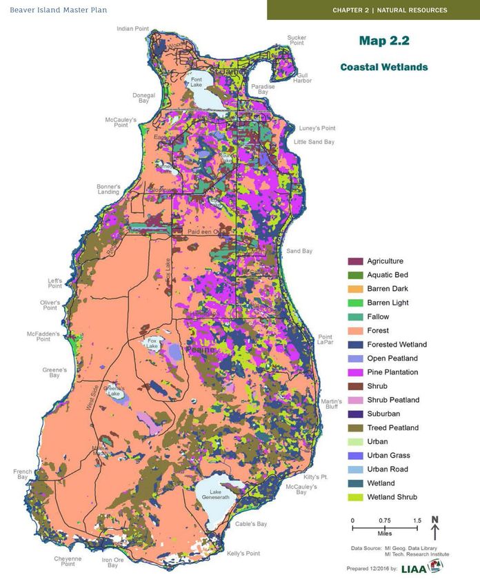
11 | B I D S S A p p l i c a t i o nFigure 8: Beaver Island Wetland Areas from Beaver Island Master Plan
Over the years, documents related to the northern Lake Michigan islands have been developed
by various organizations (e.g., Townships, County, State of Michigan, U.S. Fish & Wildlife
Service, U.S. Environmental Protection Agency, The Nature Conservancy, Michigan Natural
12 | B I D S S A p p l i c a t i o nFeatures Inventory, Little Traverse Conservancy, Little Traverse Bay Band of Odawa Indians.
John Woollam Foundation).
The documents listed below provide information on the biodiversity and integrity of native
plant and animal communities, migratory birds, fish, and threatened and endangered species,
and some reflection of the recreational and economic desires of island residents and visitors.
Many of these documents also reflect a desire to manage and maintain the natural resources
for the benefit of current and future generations. Related reports, plans or policies helped to
influence the content and direction of this plan and include:
1. Charlevoix County (2015). Charlevoix County Recreation Plan 2015 – 2019 as adopted by
Charlevoix County Board of Commissioners.
2. Charlevoix County (Update in Progress) Beaver Island Master Plan as adopted by Peaine
and St. James Townships.
3. Henson, B.L., et. al. 2010. Islands of life: a biodiversity and conservation atlas of the
Great Lakes islands. Nature Conservancy of Canada. Ontario, Canada.
4. LTBB NRD (2015) 1855 Reservation Islands – Blueprints for Biodiversity, Protection and
Restoration. Little Traverse Bay Bands of Odawa Indians Natural Resource Department.
GLRI Project Final Report Number 2015- IFWP-01.
5. MDNR (2013) Northern Lower Peninsula Regional State Forest Management Plan—
Great Lakes Islands Management Area.
6. NRESC (2013) Recommendations for Natural Resource Management in the Beaver Island
Archipelago. 7. Peaine Township (Draft) Recreation Plan 2013-2018 Peaine Township,
Beaver Island.
7. Pearsall, D., et. al. 2012. Michigami: Great Water. Strategies to Conserve the Biodiversity
of Lake Michigan. Technical Report. A joint publication of The Nature Conservancy and
Michigan Natural Features Inventory. with Appendices. Page | 3 Management Plan for
State-owned Lands on Northern Lake Michigan Islands February 2017
8. St. James Township (Draft) Recreation Plan 2012-2016 St. James Township, Beaver
Island.
9. Peaine Township (draft) Recreation Plan, Beaver Island.
10. U.S. Department of Interior, Fish & Wildlife Service (2013) Gravel Island, Green Bay,
Harbor Island, Huron, and Michigan Islands National Wildlife Refuges – Comprehensive
Conservation Plan. Region 3 (Midwest Region); Bloomington, MN. 320 pp.
11. Vigmostad, K., et al. (2007) Great Lakes islands: biodiversity elements and threats. A
final report to the Great Lakes National Program Office of the Environmental Protection
Agency.
12. West Michigan Shoreline Regional Development Commission (2014) Lake Michigan
Water Trail Plan, Phase I: Inventory and Analysis of Access Sites in Support of a Lake
Michigan Water Trail. DNR POLICIES & PROCEDURES 29.20-05 – Management of State-
owned island properties (ISSUED: 07/11/2005)
13 | B I D S S A p p l i c a t i o nCharlevoix County Beaver Head Light Park
Beaver Head Light Park is made up of three contiguous parcels of land including 1,400 feet of
Lake Michigan frontage at the south end of Beaver Island. Charlevoix County, the Michigan
county in which Beaver Island is located, owns BHLP. Most of the property is wooded and
undeveloped, but it features several historic buildings, including a lighthouse, a carriage house,
a fuel building, and a fog signal building. Academic
facilities are also located on the property, including a
school, commercial kitchen/cafeteria building, three
(3) bunk houses, and a maintenance building. The
property also features a former rustic campground,
including a well pump, two (2) outhouses and a
storage building.
The academic facilities were used for many years as an
alternative school operated by Networks Northwest in
Figure Beaver
9:Beaver
HeadHead Lighthouse
Lighthouse
an arrangement with the Charlevoix Public School
District, the prior owner of the property. The county
and community are investigating future uses for the academic facilities and the Beaver Island
Historical Society is leading community efforts to repair and restore the lighthouse in
cooperation with the county. Renovations at the site will include installation of compliant
lighting. It is envisioned that the facilities could be used in connection with educational
programs for the BIDSS.
The lighthouse is a beloved fixture on the island and is deeply intertwined in its history. It has
gone through two distinct
stages: in the nineteenth
century it was almost in a world
of its own because of the
difficulty of reaching it, but in
the twentieth a road linked it to
St. James and it became one of
the stretch points that
Figure
The fog 10:The fog signal
signal building building
has been has and
restored been hasrestored
potentialand hasaspotential
for use for
meeting and
expanded the scope of life on
use as meeting assembly facility. Itfacility.
and assembly is steps from Lake Michigan.
It is steps from Lake Michigan. Beaver Island. Its keepers gave
their names to such Island
features as Appleby's Point and Miller's Marsh, and Islanders like Owen McCauley, Dominick
Gallagher, Tom Bonner, and Bert McDonough served at the Island's far end. Over the years
docks and additional buildings were added and rebuilt. The oil light was replaced with an
electric arc in 1938, and in 1962 the Lighthouse was decommissioned. It was sold as surplus
and became a hunting club until it was acquired by the Charlevoix Public Schools in 1975.
14 | B I D S S A p p l i c a t i o nFigure 11: Developed area of Beaver Head Lighthouse Park
Central Michigan University Miller’s Marsh Research Area
The Miller’s Marsh Research Area is a 230-acre site owned by Central Michigan University
(“CMU”). It is used in conjunction with the CMU Biological Station on the east side of the
island. Miller’s Marsh is the largest and most diverse marsh
found on Beaver Island. This wetland’s diversity consists of a
combination of open shallow water, extensive sedge (to the
west), and sphagnum mats (to the east) surrounded by a vast
mature second growth beech-maple forest. It is home to
frogs, migratory birds, and waterfowl. The marsh is
biologically unique since it is the only site on Beaver Island
where blue-green algae can be found. Miller´s Marsh is an
ideal site for both aquatic and terrestrial biological research.
There is a marked nature trail that circles the marsh and that Figure 11: MMRA location on
includes several open areas that are good dark sky observation the island
sites including the “Big Field” mentioned elsewhere in this application. The trail starts and ends
at a small parking area. This area also marks the southern end of the island’s Doty’s Camp Trail.
Miller’s Marsh is named after former Beaver Head Lighthouse Keeper Harrison “Tip” Miller.
Purchased by the Little Traverse Conservancy in 1997, this property was conveyed to the
Central Michigan University Biological Station in 1998.
15 | B I D S S A p p l i c a t i o nIDA Sanctuary Definition, Eligibility and Requirement Statements
Definition of an IDA International Dark Sky Sanctuary
The BIDSS consists of mostly public land possessing an exceptional or distinguished quality of
starry nights and nocturnal environment, and is specifically protected for scientific, natural,
educational, cultural, and public enjoyment values. It differs from a Dark Sky Park or Reserve in
that it is situated in a very remote location with few nearby threats to the quality of its dark
night skies and does not otherwise fall into the category of Park or Reserve. The Beaver Island
Dark Sky Sanctuary chose the “Sanctuary” certification for the following reasons.
• The Wildlife management unit is not a “Park”. From a land manager’s perspective, this is
a specific State-managed Wildlife Research Area, accessible to the public. Management
objectives guide the promotion of sustainable ecotourism/astro-tourism.
• Management objectives guide to further the protection of nocturnal habitats, public
enjoyment of the night sky, the area’s cultural heritage, and identification of areas ideal
for professional and/or amateur astronomy.
• The BIDSS contains remote geographic locations within the area. The IDSS certification
could help increase awareness of fragile locations and help promote their long-term
conservation management.
• To encourage landowners/administrators, land managers in surrounding public lands,
communities, and private interests to identify dark skies as a valuable resource in need
of proactive conservation and preservation.
• To encourage other public land managers to become environmental leaders on dark sky
issues by communicating the importance of dark skies and by providing an example of
what is possible with proper stewardship.
Eligibility for All Sanctuaries – BIDSS Statements
The BIDSS:
1. Is publicly owned by State land agencies. The South End, Beaver Island Beaver Head
Lighthouse property is a publicly accessible property owned jointly by Charlevoix County and
Networks Northwest. All State land included in the sanctuary is legally protected for scientific,
natural, educational, cultural, heritage and/or public enjoyment purposes, and other wilderness
character qualities. Verbal permission has been granted from the co-owners of the Lighthouse
property, indicated in orange shading on the Beaver Island Map for access and use as a dark sky
viewing area.
2. Provides an opportunity for regular public nighttime access, with or without supervision.
Access is available any night. There is no need for a waiver concerning endangered wildlife,
archaeological sites, or other sensitive resources as they are already protected in this primitive
area.
3. Ensures public accessibility as all night sky viewing areas are accessible with or without
private land transit.
16 | B I D S S A p p l i c a t i o n4. Provides exceptional dark-sky resource where the night sky brightness at the zenith is
routinely equal to or darker than 21.5 magnitudes per square arc second in the visual band and
significant light domes are not present toward the local horizon in any direction. (Illustrations
below show light pollution levels for Beaver Island on the David Lorenz Light Pollution Atlas in
2006, and in 2016.
Figure 12:David Lorenz Light Pollution Atlas 2006
Figure 13:David Lorenz Light Pollution Atlas 2016
Minimum Requirements for All Sanctuaries – BIDSS Statements
1. A comprehensive Lighting Management Plan (LMP) is adopted by the Beaver Island Dark Sky
Sanctuary under the policies of the DNR Wildlife Division that holds title to and manages the
BIDSS land.
2. The BIDSS does not have or permit outdoor lighting, and we are committed to protecting this
primitive nature of the area as designated wilderness.
17 | B I D S S A p p l i c a t i o n3. Although the BIDSS does not have a lighting conformity schedule because there are no light
fixtures in the area, we are committed to keeping it that way via law, policy and guidance
related to the management of a state and federally designated wilderness area.
4. The DNR has established and will maintain a monitoring program that follows the evolution
of any light pollution in the BIDSS to ensure that the night sky quality does not degrade over
time. The Beaver Island Dark Sky Sanctuary and DNR will also consider the option of submitting
our light measurement needs as a citizen science volunteer opportunity.
5. See the section below titled “Threats to Dark Skies” for a description of current and potential
future threats to dark skies over the BIDSS. Any ecological threat to wildlife, environmental
changes, erosion, invasive species and more can threaten dark sky conditions.
6. The importance of dark skies/natural darkness is addressed in BIDSS external
communications. The dark skies theme is communicated through on-site interpretation, social
media (Beaver Island Dark Sky Project Facebook page, a Dark Sky website and other materials
for the public. As more visitors discover Beaver Island, the rich history and heritage and the
pristine lands available for exploration and dark sky viewing, these opportunities grow every
year.
7. Dark skies in the BIDSS area are acknowledged as an important scientific, natural, cultural,
and/or scenic resource value by jurisdictions higher than community level such as the, National
Forestry Service, the Fish & Wildlife Division of the DNR, EGLE, MNFI, Beaver Island Dark Sky
Sanctuary, State of Michigan, County and local governing agencies. Private investors and
conservationists recognize the value of preserving rare areas and have taken steps to install
policies that protect many areas. Examples include the recent downtown Marina acquisition
that includes a dark-sky lighting plan, recent real estate purchases of private land that have
incorporated the preservation in conjunction with said purchases and extreme efforts and
donations and preservations of tracts of land by private individuals. Sarah Martin Preserve-
2016: 150 Acres A list of donated and preserved land and nature reserves on Beaver Island can
be found at the DNR and Little Traverse Conservancy, plus the Nature Conservancy websites.
8. Once established, the BIDSS, in coordination with the DNR will erect and maintain
appropriate signage, indicating the International Dark Sky Sanctuary certification, in
appropriate locations. Beaver Island Dark Sky Sanctuary is the title currently under
consideration. BIDSS ENTRANCES, will be promoted at the local Chamber of Commerce, Library
and Community Center, referenced or indicated on existing preserves, nature parks, water trail,
bike trails, birding trails, as BIDSS entry point kiosks as approved by the IDA. Once the signs are
erected, a photograph documenting placements will be taken and sent to IDA for records, along
with a description of the locations.
9. Night sky quality has been established through:
• Measurements/calculations, maps, and photographs of possible areas within the
proposed zone that may be affected by sources of light pollution. See the section below
18 | B I D S S A p p l i c a t i o ntitled “Threats to Dark Skies” for a description of current and potential future threats to
dark skies over the BIDSS.
• A determination of whether the minimum sky quality standard has been met through
sky brightness measurements made via an IDA-approved data collection method.
Measurements were distributed over a sufficiently long enough period (summer, fall
and spring based on staff availability) in order to average out fluctuations over
timescales ranging from nights to seasons in length. The BIDSS believes that the BIDSS
management area meets the definition and eligibility requirements for certification as a
Dark Sky Sanctuary as specified in the IDA’s Dark Sky Sanctuary certification guidelines
and requirements.
Night Sky Preservation Guidance
The BIDSS is a management area within the Beaver Island State Wildlife Research Area and
legally protected for scientific, natural, educational, cultural/heritage resources and/or public
enjoyment purposes. Dark sky quality is part of that protected wilderness character fabric
already being preserved and monitored. To protect our dark skies is to add another layer of
protection for all life in these areas. To add this layer of protection, education and guidance is
the key to awareness and preservation of these skies.
The following list of natural communities was compiled by the Michigan Natural Features
Inventory (MNFI) scientists for the Michigan Department of Natural Resources during a survey
conducted in 2017. Protecting and managing representative natural communities is critical to
biodiversity conservation, since native organisms are best adapted to environmental and biotic
forces with which they have survived and evolved for over the millennia (Kost et al.2007, Cohen
et al.2015).
Figure 14: Beaver Island Archipelago Natural Communities
19 | B I D S S A p p l i c a t i o nBeaver Island’s natural resources define our community’s sense of place; we value them as a
source for beauty and spiritual well-being, economic activity and recreation, scientific
knowledge and cultural heritage, and because they provide food and fuel. Over the years, the
Archipelago has benefited from the decisions of people here and afar: decisions to protect the
Lake Michigan waterfront from rampant commercial development; to place outer islands in the
public trust for conservation; to use conservation easements and public land acquisition to
maintain natural beauty and environmental health; to develop land with environmentally
friendly practices; to monitor, enhance, and carefully manage wildlife-both plant and animal. All
of it relatively unspoiled and easily accessible to the public.
Beaver Island contains species of global significance, is listed as a high-value conservation area,
and is one of the highest ranked of 32,000 Great Lakes islands for its biodiversity. Designated as
an Important Birding Area, the Archipelago provides significant habitat for colonial water birds,
neo-tropical migratory songbirds, and rare plants, and serves as an important fish spawning and
nursery area. It’s easy to imagine that all of this will remain much as it has been without anyone
having to make an effort. It’s so vast and beautiful—what could go wrong? But we saw in the
last century, with the historic decline of fishing and the end of virgin timber logging, that this
uniqueness and abundance of natural resources can be seriously damaged when it is not
carefully maintained. By their nature, the islands of the Beaver Archipelago are more vulnerable
to external environmental threats than comparable mainland areas. For these reasons,
preservation of the living natural resources of the Beaver Archipelago requires our ongoing
monitoring and scrutiny. And now, the community embraces the idea of an IDA designation to
preserve and promote the dark sky philosophy.
Although it is a benefit being geographically isolated from the mainland's light pollution, threats
to the island's dark sky need to be mitigated and potential threats anticipated. The Beaver
Island community is known for its proactive efforts to preserve and promote the island's natural
assets. It has been a pioneer in invasive species control in the State of Michigan and serves as
an inspiration to other communities in the development of water and birding trails. As more
property is developed, best practices are being put in place to protect the very natural
experiences that have been enjoyed for generations on the island.
The International Dark Sky Sanctuary designation will ultimately enhance Beaver Island's dark
sky as owners engage in efforts to preserve its dark skies. As a point of pride for property
owners, it will serve as a model for those summer residents and visitors who hail from multiple
states across America. The island's environment will be preserved as homeowners alter their
lighting choices through information designed by the island's planning commissions and
encouraged through educational meetings with builders, real estate agents, and the Beaver
Island Association's outreach material. With engagement and encouragement from residents
and the business community along with readily available educational information, fostering
best lighting practices and nurturing residential stargazing along with neighborly good lighting,
20 | B I D S S A p p l i c a t i o nparticipation will increase. Ultimately, dark-sky friendly lighting practices will have a positive
effect on the Wildlife Research Area.
Figure 15: Depiction of 1978 land use from Beaver Island Master Plan. Not much has changed.
.
21 | B I D S S A p p l i c a t i o nProtection for Scientific, Natural, Educational, Cultural, and
Public Enjoyment Values
Scientific
The BIDSS, in conjunction with the DNR Wildlife Division recognizes that research is an
appropriate activity in the Wildlife Research Area. Any approved research project must be
conducted in a manner compatible with the preservation of wilderness values. Research
proposals are reviewed on a case-by-case basis by an interdisciplinary team. Decisions may be
based on, but not limited to, the following factors: meeting wilderness objectives; research that
is wilderness-dependent; proposed modes of travel; alternatives to proposed motorized or
mechanized equipment; and effects on wilderness values and the magnitude of the effects, as
governed by the DNR Wildlife division.
Central Michigan University Biological Station
At the Central Michigan University (“CMU”) Biological Station on Beaver Island (“CMUBS”)
biologists and students conduct many kinds of research in a variety of conditions, all at the
same time. The station boasts one of the Great Lakes basins few mesocosm facilities, where 12
water tanks simulate natural environments under controlled conditions. Current research at
the station includes studies of three wild species: bloody red shrimp, an invasive pest with a
foothold in the Great Lakes; lake whitefish, an important food source in decline; and island
chipmunks, which are more than just cute faces.
The Institute for Great Lakes Research (“IGLR”) at CMUBS takes a multidisciplinary approach to
understanding the complex environmental issues affecting the Great Lakes basin. This area
includes associated ecosystems such as tributaries, wetlands, and coastal regions, as well as the
lakes themselves. The IGLR is committed to promoting and facilitating collaborative research
and education on the Great Lakes. We partner with other institutions and agencies to leverage
our expertise and training. IGLR faculty members are nationally and internationally recognized
experts on coastal wetlands, conservation genetics, fisheries, invasive species, limnology,
aquatic population modeling, microbial ecology, landscape ecology, and geographic information
sciences. External agencies supporting research include the Environmental Protection Agency,
the U.S. Fish and Wildlife Service, the Michigan Department of Natural Resources and
Environment, and the Sea Grant.
CMUBS and IGKR have published numerous scientific articles based on research completed on
the island. Below are some examples:
https://www.cmich.edu/news/article/Pages/beaver-island-research.aspx
https://www.cmich.edu/search/Pages/default.aspx?k=beaver%20island%20research
https://www.fws.gov/uploadedFiles/TaylorHoffman2015cjz.pdf
22 | B I D S S A p p l i c a t i o nNature Conservancy and Little Traverse Conservancy
A biodiversity and conservation overview completed by David Ewert of The Nature Conservancy
clearly states the governing agencies plans to “maintain and monitor” a variety of natural
conditions on the island.2 All these plans would be enhanced and necessary to the
preservation of dark skies. See https://www.michigan.gov/documents/deq/SOLMII1030-
EwertL-MIIslandsBiodiversity_507258_7.pdf.
Statement of Mission from the Wildlife Division of the Michigan DNR
“Our Mission: To enhance, restore and conserve the State’s wildlife resources, natural
communities, and ecosystems for the benefit of Michigan’s citizens, visitors, and future
generations.
Our Principles: Public Service: The Wildlife Division believes it has the privilege and
responsibility to serve the public by managing wildlife populations and habitat for the
use and enjoyment by the citizens of Michigan and by communicating effectively and
helping ensure the public understands wildlife management.
Public Trust Responsibilities: The Wildlife Division believes in the public trust doctrine;
that wildlife resources are held in trust for the people of Michigan, and it is the privilege
and responsibility of the Division to manage those resources wisely.
Scientific Management of Wildlife Resources: The Wildlife Division believes in the
principles of scientific management of wildlife resources. Scientific management is in
the public interest, and sound science will be used to inform management decisions and
to evaluate the outcomes of those decisions.
Sustainability: The Wildlife Division believes it is our responsibility to facilitate the
resolution of wildlife issues in a fashion that conserves the long-term viability of
populations and the habitats upon which they depend.
Principles of Ecosystem Management: The Wildlife Division believes in a management
approach that integrates biological, social, and economic factors into a comprehensive
2 The overview notes that 46% of Lake Michigan island land area is protected by various conservation
organizations: Little Traverse Conservancy preserves (Beaver and St. Helena Islands) – Central Michigan University
(Beaver Island) – Michigan DNR (Beaver, High, S. and N. Fox, Garden, High, Whiskey and others) – Wisconsin DNR
(Rock Island, parts of other islands) – USFWS (Michigan Islands , Green Bay, Gravel Island National Wildlife
Refuges) • Hat, Gull, Pismire, Shoe Islands; Hog, Plum, Pilot, Rocky, St. Martin Islands; Gravel Island – Others (USFS;
Michigan Nature Association) • Protect/monitor threatened/endangered species – Piping Plover, colonial nesting
waterbirds – Pitcher's thistle, dwarf lake iris • Forest management – Maintain viable populations of all tree species
• Maintain viable populations of game, nongame species – Terrestrial and aquatic • ID, monitor, rapid response to
invasive species (10 focal species) – Common reed control (Phragmites) – Wash trucks before arriving on island –
Monitor sites most likely to receive invasive species – Quarantine hardwood logs, maybe hemlock • Improve
education, resource appreciation – Birding trail, festival (2014); bike trails – Beaver Island Water Trail.
23 | B I D S S A p p l i c a t i o nstrategy aimed at protecting and enhancing sustainability, diversity, and productivity of
wildlife resources.
Adaptive Management: The Wildlife Division recognizes that our understanding of many
ecosystem functions is incomplete and will improve with new information. Management
approaches will be viewed as hypotheses to be tested by research, monitoring, and
evaluation. This adaptive, empirical approach is useful and will be applied to processes
used by the Division whenever possible.
Trust and Credibility: The Wildlife Division believes that trust and credibility are possible
only when there is open and two-way communication.
Competence: The Wildlife Division believes that truly effective and efficient
management can be achieved when personnel are well-trained, objective, and
professional.3
These paragraphs above clearly states a policy to protect these lands within the BIDSS in
keeping with the same principles that protect dark skies.
Cultural Values
In the Odawa and Ojibwe oral tradition the Turtle Island refers to the continent of North
America. The name comes from various Indigenous oral histories that tell stories of a turtle that
holds the world on its back. For some Indigenous peoples, the turtle is therefore considered an
icon of life, and the story of Turtle Island consequently speaks to various spiritual and cultural
beliefs. In various Indigenous origin stories, the turtle is said to support the world, and is an icon
of life itself. Turtle Island therefore speaks to various spiritual beliefs about creation and for
some, the turtle is a marker of identity, culture, autonomy and a deeply-held respect for
the environment
Zooming in on the Beaver island Archipelago Dark Sky Zone is on north end of Lake Michigan
bordered by the Manitou islands to the south to the Straits of Mackinac to the north. The
archipelago is an extension of Waugoshance Point to the east. The subaerial ridges along the
cape rise approximately 13 ft (4.0 m) above lake level (an elevation of about 590 ft (180 m)
above sea level. Waugoshance Point is part of the Niagara Escarpment which originates at the
Niagara Falls in the east and extends to the north end of Lake Winnebago in Wisconsin in the
west.
Our island, situated in the remote blue waters in the great north woods, defines our heritage,
history and our connection to the water and the sky. To the Odawa Nation, who arrived on
Beaver island Archipelago 2200 years ago, the universe was created by Glitche Manitou
manifesting everything we know and those unseen things and then birth it into being. Each part
3 Available at: https://www.michigan.gov/documents/dnr/Wildlife_GPS_Strategic_Plan_434049_7.pdf.
24 | B I D S S A p p l i c a t i o nof Manitou’s creation supported the other and maintained balance: the four legged – the
animals, those beings. The Odawa indigenous astronomy reflects the connection with nature
and constitutes the difference between Western science and indigenous perspectives of the
natural world.
Teach your children well
To protect our Dark Sky, we must return to the teaching of Beaver Island Archipelago’s
indigenous ancestors, the Odawa of the Land of the Crooked Tree, that reflects the connection
and balance with nature. In the 21st Century the challenge is to define a place as a geological
location - the landscape of the Great Lakes region and especially Beaver Island with a mystical
connection with the indigenous ancestor’s myths and oral traditions.
The Loon and the North Star - Maang – Loon of the Ojibwa Constellation are present in the
summertime on Fox and Barney’s lakes on Beaver Island. The spirit of the Odawa Gizhebaa
Giizhig "Revolving Sky”’ is revealed in Beaver Island’s “Stone Circle”.
Thirty-nine stones forming a 397-foot circle were found of the western side of Beaver Island. As
the site was explored, Native American elders from the surrounding areas recalled stories of a
stone calendar located on Redding Trail, below Angeline Bluff, near Peshawbestown, which is a
historic Native American village. The site has a large stone with unknown markings in the center
of the site, with other stones seemingly arranged around it. The stones and boulder arranged
around it also have carving, which appear to be sheaths of feathers.
Research found that the stones connect to star positions and were aligned to the midsummer
solstice. The pattern of the stones is like that of a Native American medicine wheel. It is mostly
accepted that the site had a high significance and was used as an important, ceremonial site for
Native Americans who once inhabited Beaver Island.
The Northern Michigan mainland is in the remote north wood with beautiful lakes, streams,
and trails. But the sense of place and a feeling of connection on a Lake Michigan island is
different. The difference is its boundaries. On an island those boundaries open an awareness
and hone in on the individual ecosystems that comprise the whole of the island’s natural
environment. On the mainland you don’t have the same sense of the interconnection and
balance of nature
Beaver island is a magical place.
On Beaver island, in the early spring on the east side Wicklow Beach there are no buds on the
trees. Traveling south to Lake Geneserath the buds are becoming visible. Journeying past Iron
Ore Bay to Westside Drive where the western sky afternoon sunshine effects the more
pronounced budding of the beach trees. When you get to Millers Marsh, the buds on the maple
trees are almost blooming. The buds recede as you travel north and east past Fox Lake along
Hannigan’s Trail back to Wicklow beach.
25 | B I D S S A p p l i c a t i o nIn a less than eight-mile circular path, the island boundaries focus awareness and magnify your
senses, perceptions of the infinitesimal changes in nature around you. The boundaries create
an understanding microcosm of place.
You can closely follow the four seasons with the changes in colors, plants, and migration of the
waterfowl on Millers Marsh. You are in a place following the Gizhebaa Giizhig circular
movement of the sky throughout the year. The circular movement of the sun, moon, stars, and
seasons. On Beaver Island the sense of place accelerates your awareness of the seasonal and
the diurnal changes of the sun into dark sky with a connection to the Odawa indigenous
astronomy relationship with natural world.
A mystical magical Turtle Island, our island is a place that is separate from the 21st Century
advanced western world. These manitous do not exist in a hierarchy like European
gods/goddesses but are more akin to one part of the body interacting with another and the
spirit of everything; the collective is named Gitche Manitou or Skyfather
The sacred ground is where everything has its own manitou—every plant, every stone and since
their invention. These manitous do not exist in a hierarchy like European gods/goddesses but
are more akin to one part of the body interacting with another and the spirit of everything; the
collective is named Gitche Manitou or Skyfather
Manitou is one aspect of the interconnection and balance of nature. In simpler terms it can
refer to a spirit. This spirit is seen as a person as well as a concept. Everything has its own
manitou—every plant, every stone and, since their invention, even machines. These manitous
do not exist in a hierarchy like European gods/goddesses but are more akin to one part of the
body interacting with another and the spirit of everything; the collective is named Gitche
Manitou or Skyfather. The term refers to the tendency for worshipers to associate supreme
power with the sun, the sky, and/or "heaven."
Along with protecting the Dark Sky, the Manitou implores us to stop the onslaught of pollution
that is threatening the Archipelago. The Maang – Loon, Piping Plover, Bald Eagle, Common
Tern, Limestone oak fern, and Pitcher's thistle and many more Archipelago birds and plants are
endangered, threatened or species of concern.
Indigenous astronomy reflects the connection with nature and constitutes the difference
between Western science and indigenous perspectives of the natural world. All knowledge is
interconnected. The Anishinaabek (Odawa or Ojibway), keen observers of cosmological and
ecological relationships, evolved traditions, and ceremonies from this knowledge.
Understanding the synchronicity of natural and astronomical cycles is integral to Anishinaabe
cosmology and shows us how the Anishinaabe cultural worldview and philosophy are reflected
in their celestial knowledge and how indigenous knowledge relates natural phenomena to
everyday.
"Gizhebaa Giizhig," which means "Revolving Sky." The name, Gizhebaa Giizhig refers to the
circular movement of the sky throughout the year. It refers to the circular movement of the
sun, moon, stars, and seasons.
26 | B I D S S A p p l i c a t i o n"Gizhebaa" also refers to people dancing in a circular fashion around the drum arbor at
powwows. That mystical movement around a source of energy is reflected in the name of
Gizhebaa Giizhig.
This ancient knowledge of the Anishinaabe came from watching the stars move to different
regions in the night sky throughout the year and observing the relationship between seasonal
changes and stellar movement.
That feeling of "connection" constitutes the difference between western science and the
indigenous perspective of the natural world. The spiritual connection or kinship with the
natural world is what defined and sustained Native American communities for thousands of
years before the dawn of industrialized society.
The landscape of the Great Lakes region, weather patterns, sun and moon, revolving star
patterns, bird and animal migrations are affirmations of who we are, what we believe, why we
exist, and how we make sense of the world around us. Understanding the synchronicity of
these cycles, as well as the physical and metaphysical essences of creation, make up the
cosmology of the Anishinaabek.
Because stars move from east to west, the Anishinaabe believe that when we die, our spirits
travel to "Ningaabii'anong;" the Western sky. The Anishinaabek also believe that new life and
knowledge emerge from "Waabanong; " the eastern sky. Thus, many ceremonies and traditions
reflect these cardinal directions.
The constellations and star knowledge relate to seasonal changes, subsistence activities,
ceremonies, and storytelling of the Anishinaabek. Seasonal changes correlate with the
movement of stellar constellations, which, in turn, are reflected in tribal stories and
ceremonies.
Anishinaabek Constellations
The constellations and star knowledge relate to seasonal changes, subsistence activities,
ceremonies, and storytelling of the Anishinaabek. Seasonal changes correlate with the
movement of stellar constellations, which, in turn, are reflected in tribal stories and
ceremonies.
All knowledge is interconnected. The Anishinaabek, keen observers of cosmological and
ecological relationships, evolved traditions, and ceremonies from this knowledge.
Public Enjoyment Values
Dark Sky Interpretation and Education
The goal of the education program is, in a balanced and equitable way, to affect public
awareness of the purpose, values and appropriate uses of wilderness, the functioning of natural
ecosystems, and to promote the preservation of wilderness resources, especially as dark skies.
27 | B I D S S A p p l i c a t i o nYou can also read