2019 Air Quality Report for the Austin-Round Rock-Georgetown Metropolitan Statistical Area - CapCOG
←
→
Page content transcription
If your browser does not render page correctly, please read the page content below
2019 Air Quality Report for the Austin-
Round Rock-Georgetown Metropolitan
 Statistical Area
 Prepared by the Capital Area Council of Governments
 July 31, 2020

 The preparation of this report was financed through funding provided by local governments
 participating in the Central Texas Clean Air Coalition. The content, findings, opinions, and conclusions
are the work of the author(s) and do not necessarily represent findings, opinions, or conclusions of the
 individual members of the Coalition.
2019 Air Quality Report for the Austin-Round Rock-Georgetown MSA, July 31, 2020

Executive Summary
This is the annual air quality report for the Austin-Round Rock-Georgetown Metropolitan Statistical Area
(MSA) prepared by the Capital Area Council of Governments (CAPCOG) for the members of the Central
Texas Clean Air Coalition (CAC), the Texas Commission on Environmental Quality (TCEQ), and the U.S.
Environmental Protection Agency (EPA). This report serves as the region’s annual “check-in” with EPA as
part of the CAC’s participation in the Ozone (O3) Advance Program (OAP). The report covers January 1,
2019, through December 31, 2019. Under the most recent MSA definitions promulgated by the Office of
Management and Budget (OMB) in March 2020, the Austin-Round Rock-Georgetown MSA consists of
Bastrop, Caldwell, Hays, Travis, and Williamson Counties, which are the same five counties that have
been participating in regional air quality planning efforts since 2002. This is the first annual report
covering the region’s 2019-2023 Regional Air Quality Plan that was adopted in December 2018.
The report is intended to do the following:
 • Provide an update to EPA, TCEQ, and local stakeholders on the status of air quality in the Austin-
 Round Rock-Georgetown MSA through the end of 2019 (Section 1);
 • Provide an update on the latest understanding of the contribution of the region’s emissions to
 high O3 levels when they occur (Section 2);
 • Summarize the status of emission reduction measures implemented in the region in 2019
 (Section 3);
 • Detail ongoing planning activities in the region (Section 4); and
 • Identify new issues affecting air quality planning efforts in 2019 and beyond (Section 5).
Some of the highlights of the report are listed below:
 • The region’s 2019 air pollution levels continued to meet all federal air quality standards,
 although O3 levels were high enough to put the region at risk of violating the O3 standard for
 2019-2020 if O3 levels are higher in 2020;
 • There were a total of 3 days when monitored air pollution levels were considered “unhealthy for
 sensitive groups” and another 132 days when air pollution levels were considered “moderate,”
 according to EPA’s Air Quality Index (AQI);
 • PM2.5 levels measured within the region were high enough on one day to be considered
 “unhealthy for sensitive groups;”
 • While overall emissions of nitrogen oxides (NOX) continued to trend downward, emissions from
 regional power plants during the 2019 O3 season were higher than they were in 2018;
 • Emission reduction measures implemented by the state and local partners in 2019 continued to
 help significantly control regional O3 levels; and
 • CAPCOG is working with the CAC and CACAC to consider EPA’s recommendation that the region
 consider participating in EPA’s Advance Program.
This report includes information from 31 different CAC member organizations. Another eight CAC
member organizations did not provide reports this year. CAPCOG will provide an addendum to this
report to CAC members, TCEQ, and EPA, if these organizations provide reports or we receive any
updates from any other organization after this report has been submitted. A supplemental spreadsheet
provides details of each organization’s reported activities.

 Page 2 of 69

2019 Air Quality Report for the Austin-Round Rock-Georgetown MSA, July 31, 2020

Table of Contents
Executive Summary ....................................................................................................................................... 2
Table of Contents .......................................................................................................................................... 3
List of Acronyms ............................................................................................................................................ 6
1 Air Quality Status .................................................................................................................................. 7
 1.1 Compliance with the NAAQS ........................................................................................................ 8
 1.2 O3 Design Value Trend ................................................................................................................ 11
 1.3 Maximum Daily 8-Hour O3 Averages in the Region .................................................................... 13
 1.4 Daily Pollution Levels Compared to EPA’s AQI ........................................................................... 14
 High AQI Days by Pollutant ................................................................................................. 14
 High O3 AQI Days by Monitoring Station ............................................................................ 16
 High PM AQI Days by Monitoring Station ........................................................................... 16
 Distribution of “Moderate” or Worse AQI Days by Month ................................................ 17
 Seasonal O3 Exposure ......................................................................................................... 18
 1.5 Air Quality Forecasting ................................................................................................................ 19
 O3 Action Days..................................................................................................................... 19
 Daily Air Quality Forecasts .................................................................................................. 21
 Odor Complaints ................................................................................................................. 22
2 2019 Regional O3 Season Weekday NOX Emissions Profile................................................................. 23
 2.1 NOX Emissions by Source Type by County .................................................................................. 25
 2.2 On-Road Sources ......................................................................................................................... 25
 2.3 Non-Road Sources ....................................................................................................................... 26
 2.4 Point Sources .............................................................................................................................. 27
 2.5 Area Sources ............................................................................................................................... 31
3 Implementation of 2019-2023 Regional Air Quality Plan and Other Measures ................................. 32
 3.1 Regional and State-Supported Measures ................................................................................... 32
 Vehicle Emissions Inspection and Maintenance Program .................................................. 32
 Drive a Clean Machine Program ......................................................................................... 35
 Texas Emission Reduction Plan Grants ............................................................................... 37
 Texas Volkswagen Environmental Mitigation Program (TxVEMP) ..................................... 39
 Commute Solutions Program .............................................................................................. 40
 Clean Air Partners Program ................................................................................................ 45
 Outreach and Education Measures .................................................................................... 46
 PACE Program ..................................................................................................................... 54
 3.2 Organization-Specific Measures and Updates ............................................................................ 55
 Emission Reduction Measures ............................................................................................ 56
 Texas Lehigh Cement Company .......................................................................................... 57
 Idling Restrictions................................................................................................................ 58
 Other Notable Distinctions for Local Communities ............................................................ 59
4 Ongoing Planning Activities ................................................................................................................ 60
 4.1 Clean Air Coalition Meetings ....................................................................................................... 60
 4.2 LSCFA ........................................................................................................................................... 60
 4.3 Statewide Collaborative Initiatives ............................................................................................. 60
 Texas Clean Air Working Group .......................................................................................... 60
 4.4 Regional Air Quality Technical Research Activities ..................................................................... 61
 Technical Working Group for Mobile Source Emissions ..................................................... 61
 4.5 EPA Travel Efficiency Assessment Method Technical Assistance Project ................................... 61
 4.6 CapMetro Bus Electrification Initiative ....................................................................................... 62

 Page 3 of 69
2019 Air Quality Report for the Austin-Round Rock-Georgetown MSA, July 31, 2020

 4.7 2019 Commuter Survey .............................................................................................................. 62
5 Planning for the Future ....................................................................................................................... 63
 5.1 EPA Proposals to Retain Existing NAAQS for O3 and PM2.5 ......................................................... 63
 5.2 2020 Update to Austin Energy’s Generation Plan ...................................................................... 64
 5.3 State and Local Revenue Reductions and Limits......................................................................... 65
 5.4 Texas Emission Reduction Plan ................................................................................................... 66
 5.5 TxVEMP ....................................................................................................................................... 66
 5.6 Inspection and Maintenance Program Changes ......................................................................... 67
 5.7 Forthcoming MOVES 2020 Release............................................................................................. 67
 5.8 Relocation of Monitoring Stations .............................................................................................. 67
 5.9 Transition of Commute Solutions Program to CAMPO ............................................................... 68
 5.10 Rider 7 Local Air Quality Grant Program ..................................................................................... 68
 5.11 Air Quality Study Related to Transportation and COVID-19 ....................................................... 68
 5.12 Clean Air Coalition Consideration of Participation in PM Advance ............................................ 68
6 Conclusion ........................................................................................................................................... 69

Table 1-1. NAAQS Currently in Effect ............................................................................................................ 9
Table 1-2. Summary of Criteria Pollutant Measurement Periods at Federal Reference Method (FRM)
Monitors in the Austin-Round Rock-Georgetown MSA, 1/1/2017 – 12/31/2019 ...................................... 10
Table 1-3. Fourth-highest MDA8 Measurements at All O3 Monitoring Stations in the CAPCOG Region,
2017-2019 (ppb) ......................................................................................................................................... 13
Table 1-4. Summary of AQI for NO2, O3, PM2.5, and PM10 ........................................................................... 14
Table 1-5. OAD Dates and Dates when O3 Exceeded Level of NAAQS, 2017-2019 .................................... 20
Table 2-1. 2019 OSD Weekday NOX Emissions by Source Type and County (tons per day) ....................... 25
Table 2-2. 2019 Austin-Round Rock-Georgetown OSD Weekday NOX Emissions by Source Use Type (tpd)
 .................................................................................................................................................................... 26
Table 2-3. 2019 O3 Season Weekday Non-Road OSD Weekday NOX Emissions by County (tpd) ............... 26
Table 2-4. Estimated 2019 Point Source OSD NOX Emissions by County (tpd) ........................................... 27
Table 2-5. Estimated Average 2019 OSD Point Source Emissions in the Austin-Round Rock-Georgetown
MSA (tpd) .................................................................................................................................................... 28
Table 2-6. Area Source OSD Weekday NOX Emissions by County and Source Type (tpd) .......................... 31
Table 3-1. I-M Program Statistics for 2019 ................................................................................................. 33
Table 3-2. 2018 and 2019 I-M Program Waivers ........................................................................................ 35
Table 3-4. Quantified OSD Weekday NOX Emissions from TERP Grants by Program from Grants Awarded
through August 31, 2019 (tpd).................................................................................................................... 38
Table 3-5. TERP Grants Awarded in the Austin Area in FY 2019 ................................................................. 38
Table 3-6. TxVEMP Grant Funding for Austin Area as of 7/16/2019 .......................................................... 39
Table 3-7. Top 10 Commute Solutions Website Pages by Page Views, 2019 ............................................. 41
Table 3-8. Commute Solutions Facebook Metrics, 2019 ............................................................................ 42
Table 3-9. Commute Solutions Newsletters Campaign Summary, 2019 .................................................... 43
Table 3-10. myCommuteSolutions Data, 2019 ........................................................................................... 44
Table 3-11. Top 10 Air Central Texas Website Pages by Pageviews, 2019 ................................................. 48
Table 3-12. ACT Facebook Metrics, 2019.................................................................................................... 50
Table 4-1. EPA TEAM Analysis Results of Daily VMT (mi) and Emission (kg) Reductions by Scenario
Compared to the 2040 BAU ........................................................................................................................ 62
Table 5-1. Updated FY 2020-2021 Revenue Estimates for Texas Air Quality Accounts ............................. 66

 Page 4 of 69

2019 Air Quality Report for the Austin-Round Rock-Georgetown MSA, July 31, 2020

Figure 1-1. 2019 Air Quality Monitors in the Austin-Round Rock-Georgetown MSA and CAPCOG Counties
Cited in the Report ........................................................................................................................................ 8
Figure 1-2. Austin-Round Rock-Georgetown MSA Design Values as a percentage of Primary NAAQS ..... 11
Figure 1-3. Austin-Round Rock-Georgetown MSA 8-Hour O3 Design Value and 4th-Highest MDA O3 Trend
2010-2019 ................................................................................................................................................... 12
Figure 1-4. CAMS 3 4th-Highest MDA8 O3 Values, Trendline, and 95% Confidence Intervals, 2010-2019 13
Figure 1-5. Number of "Moderate" or ”Unhealthy for Sensitive Groups” Air Pollution Days in the CAPCOG
Region in 2019 by Pollutant ........................................................................................................................ 15
Figure 1-6. Days in 2019 When AQI Levels in the MSA Were "Moderate" or Worse ................................. 15
Figure 1-7. Number of Days when MDA8 O3 Pollution was "Moderate" or Worse by Monitoring Station,
2019 ............................................................................................................................................................ 16
Figure 1-8. Number of Days when PM2.5 Pollution was "Moderate" or Worse by Monitoring Station, 2019
 .................................................................................................................................................................... 17
Figure 1-9. Number of Days when Air Pollution was "Moderate" or Worse in the Austin-Round Rock-
Georgetown MSA by Month, 2019 ............................................................................................................. 18
Figure 1-10. Weighted Seasonal O3 Exposure by Monitoring Station and 3-month period, 2019 (W126
ppm-hrs)...................................................................................................................................................... 19
Figure 1-11. OAD Forecast Accuracy and Success, 2017-2019 ................................................................... 21
Figure 1-12. Accuracy and Success of AQI Forecasts for 2019 ................................................................... 22
Figure 1-13. 2019 Odor Complaints and # of Complaints Per 10,000 Residents by County....................... 22
Figure 1-14. Statewide and Austin-Round Rock-Georgetown MSA Odor Complaints per 10,000 Residents
2014 – 2019 ................................................................................................................................................ 23
Figure 2-1. Ozone Formation ...................................................................................................................... 24
Figure 2-2. 2019 O3 Season Weekday NOX Emissions for the Austin-Round Rock-Georgetown MSA (tpd)
 .................................................................................................................................................................... 25
Figure 2-3. Comparison of EGU NOX Emissions on Top 4 O3 Days at CAMS 3 Compared to Average Daily
NOX Emissions May 1 – September 30, 2019 .............................................................................................. 30
Figure 2-4. Average Daily May – September NOX Emissions from EGU Point Sources in Austin-Round
Rock-Georgetown MSA and Surrounding Counties, 2010-2019................................................................. 31
Figure 3-1. Trend in Emissions Inspections Compared to Population in Travis and Williamson Counties
2006-2019 ................................................................................................................................................... 34
Figure 3-2. Initial Emissions Inspection Failure Rate Trend 2006-2019 ...................................................... 34
Figure 3-3. 2019 Emission Test Failure Rate by Model Year ....................................................................... 35
Figure 3-4. DACM Repair and Replacement Voucher Trends 2009-2019 ................................................... 36
Figure 3-5. Commute Solutions Website Traffic, 2019 ............................................................................... 41
Figure 3-6. Commute Solutions Website Acquisition Method, 2019 ......................................................... 41
Figure 3-7. Commute Solution Facebook Post Example ............................................................................. 43
Figure 3-8. Example Commute Solutions Newsletter Article from the April 2019 Newsletter .................. 44
Figure 3-9. Air Central Texas Website Traffic, 2019.................................................................................... 47
Figure 3-10. Air Central Texas Website Acquisition Method, 2019 ............................................................ 47
Figure 3-11. Sample Newsletter Article from the March 2019 ACT Newsletter......................................... 50
Figure 3-12. Air Central Texas Facebook Post Example .............................................................................. 51
Figure 3-13. 2019 ACT Awards Graphic ...................................................................................................... 52
Figure 3-14. Vehicle Maintenance ACT Graphic ......................................................................................... 54
Figure 3-15. Hourly NOX Emissions at Texas Lehigh on OADs and Actual O3 Exceedance Days compared to
Other Days, 2019 ........................................................................................................................................ 58

 Page 5 of 69

2019 Air Quality Report for the Austin-Round Rock-Georgetown MSA, July 31, 2020

List of Acronyms
AACOG: Alamo Area Council of Governments MDA8: Maximum Daily 8-Hour Average
AFFP: Alternative Fueling Facilities Program µg/m3: Micrograms per cubic meter
AQI: Air Quality Index MOVES: Motor Vehicle Emissions Simulator
CAC: Clean Air Coalition MSA: Metropolitan Statistical Area
CACAC: Clean Air Coalition Advisory Committee NAAQS: National Ambient Air Quality Standards
CAMPO: Capital Area Metropolitan Planning NOX: Nitrogen oxides
Organization
 NO2: Nitrogen dioxide
CAPCOG: Capital Area Council of Governments
 NTIG: New Technology Implementation Grant
CapMetro: Capital Metropolitan Transit
 O3: Ozone
Authority
 OAD: Ozone Action Day
CAMS: Continuous Air Monitoring Station
 OAP: Ozone Advance Program
CAPP: Clean Air Partners Program
 PACE: Property-Assessed Clean Energy
CO: Carbon Monoxide
 Pb: Lead
CSB: Clean School Bus
 PM2.5: Particulate matter with a diameter of 2.5
CTRMA: Central Texas Regional Mobility
 microns or less
Authority
 PM10: Particulate matter with a diameter of 10
CTT: Clean Transportation Triangle
 microns or less
DACM: Drive a Clean Machine
 PPB: Parts per billion
DERI: Diesel Emission Reduction Incentive
 PPM: Parts per million
DFW: Dallas-Fort Worth
 SIP: State Implementation Plan
DTIP: Drayage Truck Incentive Program
 SO2: Sulfur dioxide
EAC: Early Action Compact
 TCEQ: Texas Commission on Environmental
EE/RE: Energy efficiency and renewable energy Quality
EPA: U.S. Environmental Protection Agency TDM: Travel Demand Management
ERIG: Emission Reduction Incentive Grant TERP: Texas Emission Reduction Plan
Program
 TCFP: Texas Clean Fleet Program
I/M: Inspection and maintenance
 TNGVGP: Texas Natural Gas Vehicle Grant
ILA: Inter-Local Agreement Program
LCRA: Lower Colorado River Authority TxDOT: Texas Department of Transportation
LSCFA: Lone Star Clean Fuels Alliance TexN: Texas NONROAD Model
LIP: Local Initiative Project VMT: Vehicle Miles Traveled
LIRAP: Low-Income Vehicle Repair, Retrofit, and VOC: Volatile Organic Compound
Accelerated Vehicle Retirement Program

 Page 6 of 69

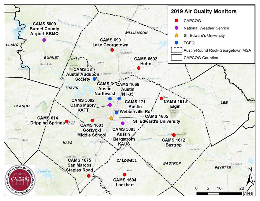
1 Air Quality Status
The following bullet points summarize the status of the Austin-Round Rock-Georgetown MSA’s air
quality status as of the end of 2019:
 • Air pollution levels throughout the metro area remained in compliance with all National
 Ambient Air Quality Standards (NAAQS), although the region’s 2017-2019 O3 levels were just 1%
 below the 2015 O3 NAAQS.
 • Through the end of 2019, City of Austin is the 2nd-largest in the U.S. with air pollution levels in
 compliance with all NAAQS, and is the largest city in the U.S. designated
 “attainment/unclassifiable” for all NAAQS (San Jose, which is the next-largest city, also attains all
 NAAQS, but Santa Clara County where it is located, is part of the San Francisco Bay O3
 nonattainment area).
 • All five of the counties in the Austin-Round Rock-Georgetown MSA remain designated as
 “attainment/unclassifiable” for the 2015 O3 NAAQS and all other NAAQS.
 • The region recorded two days when O3 levels were considered “unhealthy for sensitive groups,”
 as well as an additional 132 days when either O3 or PM2.5 levels were considered “moderate,”
 based on EPA’s AQI.
 • The region’s cumulative seasonal O3 levels were 55% below the levels that EPA considers
 harmful to vegetation.
 • TCEQ has not completed a new review of air toxics data collected at CAMS 171 since 2017,
 which reflected 2016 data. That review, however, found that all air toxics levels measured were
 below the levels that would be expected to cause adverse health or environmental impacts.
 • One out of five TCEQ Ozone Action Day (OAD) forecasts correctly predicted O3 levels > 70 ppb.
 • Overall, TCEQ’s daily AQI forecasts correctly predicted “moderate” or worse air quality 56% of
 the time, but they only were able to predict 45% of all days when the AQI levels were
 “moderate” or worse within the region.
 • There were a total of 870 odor complaints reported to the TCEQ from within the Austin-Round
 Rock-Georgetown MSA in 2019, up significantly from the 476 reported in 2018, and higher on a
 per-capita basis (3.91) that the number of complaints per capita statewide (3.15).

While the region was able to narrowly remain in compliance with the NAAQS through the end of 2019,
there were a total of two days when air pollution levels within the region was considered “unhealthy for
sensitive groups” for ground-level O3.
The following map shows the locations of all of the Continuous Air Monitoring Stations (CAMS) that
collect air pollution and meteorological data around the Austin-Round Rock-Georgetown MSA, including
the monitors operated by TCEQ, CAPCOG, St. Edward’s University, and the National Weather Service.

2019 Air Quality Report for the Austin-Round Rock-Georgetown MSA, July 31, 2020

Figure 1-1. 2019 Air Quality Monitors in the Austin-Round Rock-Georgetown MSA and CAPCOG Counties Cited in the Report

1.1 Compliance with the NAAQS
The Austin-Round Rock-Georgetown MSA’s 2019 design values for carbon monoxide (CO), nitrogen
dioxide (NO2), O3, particulate matter with diameters of 2.5 micrometers or less (PM2.5), particulate
matter with diameters of 10 micrometers or less (PM10), and sulfur dioxide (SO2) were all in compliance
with the applicable NAAQS. Lead (Pb) is not monitored within the region. Table 1-1 shows all of the
NAAQS currently in effect.

 Page 8 of 69
Table 1-1. NAAQS Currently in Effect

 Pollutant Standard Type Averaging Time Level Form Impacts of Violating the NAAQS
 9 parts per Not to be exceeded more than
 Primary 8 hours Neurological and cardiovascular impacts,
 million (ppm) once per year
 CO particularly for individuals who are
 Not to be exceeded more than
 Primary 1 hour 35 ppm exercising or under stress
 once per year
 Primarily neurological problems for
 0.15
 children and cardiovascular problems for
 Primary and Rolling 3-month micrograms
 Pb Not to be exceeded adults, but numerous other health impacts
 Secondary average per cubic
 as well; ecological damage from
 meter (µg/m3)
 deposition
 98th percentile of 1-hour daily Respiratory impacts to people with lung
 100 parts per
 Primary 1 hour maximum concentrations, disease such as asthma, children and
 billion (ppb)
 averaged over 3 years teens, older adults, and people who are
 NO2
 active outdoors; contributes to acid rain,
 Primary and
 1 year 53 ppb Annual mean visibility impairment, and nutrient
 Secondary
 pollution in coastal waters
 Annual fourth-highest daily Respiratory impacts to people with lung
 Primary and maximum 8-hour disease such as asthma, children and
 O3 8 hours 0.070
 Secondary concentration, averaged over teens, older adults, and people who are
 3 years active outdoors; impacts on plant growth
 Annual mean, averaged over 3
 Primary 1 year 12.0 µg/m3
 years
 PM2.5 Respiratory and cardiovascular impacts on
 3 Annual mean, averaged over 3
 Secondary 1 year 15.0 µg/m people with lung or heart disease
 years
 (respectively), older adults, children, and
 Not to be exceeded more than
 Primary and teenagers; visibility impairment
 PM10 24 hours 150 µg/m3 once per year on average over
 Secondary
 3 years
 99th percentile of 1-hour daily Respiratory impacts to people with lung
 Primary 1 hour 75 ppb maximum concentrations, disease such as asthma, children and
 SO2 averaged over 3 years teens, older adults, and people who are
 Not to be exceeded more than active outdoors; impacts plant growth and
 Secondary 3 hours 0.5 ppm
 once per year contributes to acid rain
There are four “regulatory” monitoring stations in the Austin-Round Rock-Georgetown MSA, all located
in Travis County, that reported data to EPA and were used for comparisons to the NAAQS. Table 1-2
summarizes the Federal Reference Method (FRM)/Federal Equivalent Method (FEM) monitors in the
region and the years for which data are available from 2017-2019. CAMS 1068 is the region’s designated
“near-road” monitor.
Table 1-2. Summary of Criteria Pollutant Measurement Periods at Federal Reference Method (FRM) Monitors in the Austin-Round
Rock-Georgetown MSA, 1/1/2017 – 12/31/2019

 CAMS 3 CAMS 38 CAMS 171 CAMS 1068
 Sampler (AQS Site (AQS Site (AQS Site (AQS Site
 Pollutant
 Type Number Number Number Number
 484530014) 484530020) 484530021) 484531068)
 Continuous, 1/1/2017 –
 CO n/a n/a n/a
 regulatory 12/31/2019
 Continuous, 1/1/2017 – 1/1/2017 –
 NO2 n/a n/a
 regulatory 12/31/2019 12/31/2019
 Continuous, 1/1/2017 – 1/1/2017 –
 O3 n/a n/a
 regulatory 12/31/2019 12/31/2019
 Continuous,
 1/1/2017 –
 PM2.5 non- n/a n/a n/a
 12/31/2019
 regulatory
 Continuous, 4/27/2017 – 10/25/2018 –
 PM2.5 n/a n/a
 regulatory 12/31/2019 12/31/2019
 Non-
 1/1/2017 – 1/1/2017 – 1/7/2017 –
 PM2.5 continuous, n/a
 2/6/2017 12/31/2019 11/22/2018
 regulatory
 Non- 1/1/2017 – 1/1/2017 –
 PM10 continuous, n/a 12/31/2019 12/31/2019 n/a
 regulatory
 Continuous, 1/1/2017 –
 SO2 n/a n/a n/a
 regulatory 12/31/2019
Figure 1-2 shows the metro area’s 2018 and 2019 design values compared to each primary NAAQS. The
2019 design value for 8-hour O3 was higher than 2018, also the design values for PM2.5 saw an increase
in 2019 compared to 2018.1

1
 Data for all pollutants other than PM10 obtained from EPA design value reports posted at:
https://www.epa.gov/air-trends/air-quality-design-values. PM10 figure calculated as 4th-highest recorded 24-hour
PM10 concentration over a 3-year period from data from TCEQ’s website.

 Page 10 of 69
Figure 1-2. Austin-Round Rock-Georgetown MSA Design Values as a percentage of Primary NAAQS

 99%
 97%
 82%
 82%

 66%
 63%

 47% 43%
 43%

 23% 31%
 20% 23%
 14%
 7% 7% 4% 4%

 CO 1-hr CO 8-hr NO2 NO2 1-hr O3 8-hr PM2.5 PM2.5 PM10 daily SO2 1-hr
 annual annual daily

 2018 2019

As part of its 2019-2023 Regional Air Quality Plan, the CAC defined “near-nonattainment” as having a
design value of at least 85% of any NAAQS. Based on this criteria, O3 remains the only pollutant for
which the Austin area is classified as “near-nonattainment”; although, the annual PM2.5 levels are close
to being within that range.

1.2 O3 Design Value Trend

Figure 1-3 below shows the trend in the Austin-Round Rock-Georgetown MSA’s 8-hour O3 design values
from 2010-2019 compared to the 2008 and 2015 8-hour O3 NAAQS, along with the 4th-highest Maximum
Daily 8-Hour Average (MDA8) O3 at each regulatory O3 station. MDA8 is the daily maximum 8-hour
concentration for a given calendar day that is the highest of the 24 possible 8-hour average
concentrations computed for that day.

 Page 11 of 69
Figure 1-3. Austin-Round Rock-Georgetown MSA 8-Hour O3 Design Value and 4th-Highest MDA O3 Trend 2010-2019

 78
 76
 8-Hour O3 Design Value (ppb)

 75
 74 74 74
 73
 72
 70
 69 69 69
 68 68 68
 66 66
 64
 62
 60

 C3 4th High C38 4th High 2008 Standard
 2015 Standard Design Value

After a 3 ppb increase in the design value from 2016 to 2017, the region experienced a 1 ppb decrease
from 2017 to 2018. While the 4th-highest MDA8 O3 at CAMS 3 (65 ppb) was much lower in 2019 than it
was in 2018, due to three-year averaging for the design value and the fact that the 4th-highest MDA8 O3
in 2019 was higher than it was in 2016 (64 ppb), the 2017-2019 design value was actually 1 ppb higher
than the 2016-2018 design value.2
Figure 1-4 below shows the 4th highest MDA8 O3 values at CAMS 3 since 2010 and compares these
values to the trendline and the 95% confidence range3. In 2019, the 4th-highest value was within the 95%
confidence range. This indicates that the region experienced a 4th-highest MDA8 O3 value at CAMS 3 that
was within expectations.

2
 Note that CAMS 3’s official 4th highest MDA8 in 2019 was 65 ppb due to EPA’s data-handling conventions that
allows 6-hour and 7-hour averages to be used if a full 8-hour average is not available, when resulted in the region’s
official design value being 69 ppb. However, TCEQ’s LEADS system appears to only include full 8-hour averages,
and the 4th-highest full MDA8 O3 at CAMS 3 was 63 ppb, which would have led to a 68 ppb design value as
suggested on TCEQ’s website. CAPCOG became aware of this discrepancy after EPA’s 2019 design value reports
were posted, and is therefore displaying the official data for 2019, but the 4th-highest data for 2010-2018 for now.
3
 95% confidence interval range is based on the standard deviation for the 3-year design value period associated
with that year. So, the standard deviation applicable to the 2019 data reflected 2017-2019 data.

 Page 12 of 69
Figure 1-4. CAMS 3 4th-Highest MDA8 O3 Values, Trendline, and 95% Confidence Intervals, 2010-2019

 80
 4th-Highest MDA8 O3 (ppb)

 75

 70

 65
 y = -0.4909x + 1059.2

 60
 2010 2011 2012 2013 2014 2015 2016 2017 2018 2019

 CAMS 3 4th-High Trendline Linear (Trendline)

1.3 Maximum Daily 8-Hour O3 Averages in the Region
While compliance with the O3 NAAQS is based on readings recorded at “regulatory” Federal Reference
Method (FRM) or Federal Equivalent Method (FEM) O3 samplers, there are also a number of non-
regulatory O3 monitoring stations in the region that can be used to understand regional O3 levels.
In addition to the two regulatory O3 monitors that TCEQ operates, CAPCOG collected O3 data at eight
monitoring stations and St. Edward’s University collected data at one additional O3 monitoring station
between 2017 and 2019. These monitoring stations use EPA-approved O3 sampling methods and data
collected during this period followed a Quality Assurance Project Plan (QAPP) approved by TCEQ.
However, these were not operated as FRM or FEM monitors, and they are not reported to EPA.

Table 1-3 summarizes the fourth-highest MDA8 O3 measurements collected at each monitoring station
in the CAPCOG region in 2017, 2018, and 2019, as well as the three-year average for each station. CAMS
3 and 38 are the “regulatory” monitoring stations operated by TCEQ, while CAMS 614, 690, 1603, 1604,
1612, 1613, 1675, and 6602 are research monitoring stations operated by CAPCOG. CAMS 1612 and
1613 are new sites for CAPCOG in 2019. CAMS 1605 is owned and operated by St. Edward’s University.
Reports documenting the quality-checks performed at CAPCOG’s sites can be found on CAPCOG’s
website at http://www.capcog.org/divisions/regional-services/aq-reports.

Table 1-3. Fourth-highest MDA8 Measurements at All O3 Monitoring Stations in the CAPCOG Region, 2017-2019 (ppb)

 AQS Site 2017-2019 2017-2019
 CAMS County 2017 2018 2019
 Number Average St. Dev.
 3 484530014 Travis 70 72 65 69 3.6
 38 484530020 Travis 67 70 63 66 3.5
 614 482090614 Hays 67 69 64 66 2.5

 Page 13 of 69
AQS Site 2017-2019 2017-2019
 CAMS County 2017 2018 2019
 Number Average St. Dev.
 690 484910690 Williamson 70 69 67 68 1.5
 1603 484531603 Travis 59 73 64 65 7.1
 1604 480551604 Caldwell 67 66 61 64 3.2
 1605 484531605 Travis 51 66 58 58 7.5
 1612 480211612 Bastrop n/a n/a 59 59 n/a
 1613 480211613 Bastrop n/a n/a 60 60 n/a
 1675 482091675 Hays 63 74 63 66 6.4
 6602 484916602 Williamson 65 68 60 64 4.0

These data generally show that the 2017-2019 three-year average of the fourth highest MDA8 values in
the region ranged from 58 ppb – 69 ppb, with CAMS 3 and CAMS 690 recording the highest of that
range.

1.4 Daily Pollution Levels Compared to EPA’s AQI
While regulatory compliance is an important indicator of a region’s air quality, it is possible for an area
to experience numerous NAAQS exceedances multiple times in a given year and still have a compliant
design value. A design value also does not directly indicate how frequently a region experienced high
pollution levels. Another indicator that can be used to characterize a region’s air quality is the number of
days a region experiences air pollution levels that fall within each of the AQI categories established by
EPA. Table 1-4 shows the concentrations of NO2, O3, and PM2.5 that correspond to each AQI level.
Table 1-4. Summary of AQI for NO2, O3, PM2.5, and PM10

 NO2 O3 PM2.5 PM10
 AQI
 AQI Level (1-Hr., (8-Hr., (24 hr., (24 hr.,
 Number
 ppb) ppb) µg/m3) µg/m3)
 Good 0-50 0-53 0-54 0.0-12.0 0-54
 Moderate 51-100 54-100 55-70 12.1-35.4 55-154
 Unhealthy for Sensitive
 101-150 101-360 71-85 35.5-55.4 155-254
 Groups
 Unhealthy 151-200 361-649 86-105 55.5-150.4 255-354
 Very Unhealthy 201-300 650-1249 106-200 150.5-250.4 355-424
 Hazardous 301-500 1250-2049 201-600 250.5-500 425-604
This report includes data from all of the air pollution monitoring stations in the region, not just the TCEQ
regulatory monitors that are used for formal AQI reporting to TCEQ. Therefore, the number of days in
the “moderate” and “unhealthy for sensitive groups” categories described below are higher than if only
the TCEQ regulatory monitors were used.

 High AQI Days by Pollutant
The following figures show the number of days in 2019 when PM2.5, PM10, or O3 concentrations
measured in the CAPCOG region were high enough to be considered “moderate” or “unhealthy for
sensitive groups.” Monitored pollution levels for CO, NO2, SO2, and PM10 all remained in the “good”
range throughout the year. In total, the region experienced moderate or worse air quality on 37% of

 Page 14 of 69
days in 2019, with 3 of those days reaching “unhealthy for sensitive groups” levels. Note that for PM10,
sampling only occurs once every six days. Therefore, while there were zero recorded “moderate” PM10
days in 2019, there could have been some days that were not “good.”
Figure 1-5. Number of "Moderate" or ”Unhealthy for Sensitive Groups” Air Pollution Days in the CAPCOG Region in 2019 by
Pollutant

 3

 1

 2 132
 87
 56
 0 0

 CO, NO2, and SO2 PM2.5 PM10 O3 Any Pollutant

 Moderate Unhealthy for Sensitive Groups

High levels of O3 were responsible for the majority of the days when the region experienced air pollution
levels considered “unhealthy for sensitive groups”. However, high levels of PM2.5 were responsible for a
majority of the days when air pollution levels were considered “moderate.” Figure 1-6 shows the
distribution of days when air pollution was considered at least “moderate” by pollutant.
Figure 1-6. Days in 2019 When AQI Levels in the MSA Were "Moderate" or Worse

 O3 and PM2.5
 8%

 PM2.5 Only
 57%
 O3 Only
 35%

 Page 15 of 69
High O3 AQI Days by Monitoring Station
The following figures show the number of days when O3 levels were considered “moderate” or
“unhealthy for sensitive groups” at each O3 monitoring station in the region in 2019. CAMS 38, CAMS
614, and CAMS 1603 recorded ozone levels that were “unhealthy for sensitive groups” on two days in
2019.
Figure 1-7. Number of Days when MDA8 O3 Pollution was "Moderate" or Worse by Monitoring Station, 2019

 1
 1 1

 38
 28 30 28
 26 27

 15 14
 12
 6 7

 Moderate Unhealthy for Sensitive Groups

 High PM AQI Days by Monitoring Station
Figure 1-8 shows the number of days when PM2.5 levels were considered “moderate” or “unhealthy for
sensitive groups” at each PM2.5 monitoring station in the region in 2019. These data are based on daily
average PM2.5 levels collected from continuous samplers at CAMS 3, CAMS 171, and CAMS 1068, which
are all located within the City of Austin.

 Page 16 of 69
Figure 1-8. Number of Days when PM2.5 Pollution was "Moderate" or Worse by Monitoring Station, 2019

 1

 85
 75

 25

 CAMS 3 (Austin NW) CAMS 171 (Webberville Rd) CAMS 1068 (IH 35)

 Moderate Unhealthy for Sensitive Groups

CAMS 171 recorded the highest number of “moderate” days for PM2.5 pollution. Whereas, CAMS 1068
recorded 10 less “moderate” days than CAMS 171, but CAMS 1068 recorded the only day in 2019 when
PM2.5 levels reached “unhealthy for sensitive groups.” January 1, 2019, was the day at CAMS 1068 that
recorded PM2.5 levels that were “unhealthy for sensitive groups,” and this was most likely due to New
Year’s Eve fireworks.

 Distribution of “Moderate” or Worse AQI Days by Month
Air pollution levels vary significantly by month in the CAPCOG region. Figure 1-9 shows the number of
days when air pollution levels were “moderate” or “unhealthy for sensitive groups” within the region by
month.

 Page 17 of 69
Figure 1-9. Number of Days when Air Pollution was "Moderate" or Worse in the Austin-Round Rock-Georgetown MSA by Month,
2019

 1

 17 17
 14 14 1 13
 1 12 12 12
 8
 4 4 5

 Jan. Feb. Mar. Apr. May Jun. Jul. Aug. Sep. Oct. Nov. Dec.

 Moderate Unhealthy for Sensitive Groups

For “unhealthy for sensitive groups,” the one day in January was due to PM2.5, whereas O3 caused the
other two days in the year.

 Seasonal O3 Exposure
While EPA set the 2015 secondary O3 standard identical to the 2015 primary O3 standard, the preamble
to the rulemaking states that, “the requisite protection will be provided by a standard that generally
limits cumulative seasonal exposure to 17 ppm-hours (ppm-hrs) or lower, in terms of a 3-year W126
index.”4 EPA did not set a separate secondary standard set to protect public welfare, as opposed to
public health, because, “such control of cumulative seasonal exposure will be achieved with a standard
set at a level of 0.070 ppm, and the same indicator, averaging time, and form as the current standard.”5
The region’s peak seasonal O3 exposure levels were 55-70% below the 17 ppm-hr levels EPA referenced
in the final 2015 O3 NAAQS rulemaking. Figure 1-10 shows the 3-month seasonal exposure levels at each
monitoring station.

4
 80 FR 65294
5
 Ibid.

 Page 18 of 69
Figure 1-10. Weighted Seasonal O3 Exposure by Monitoring Station and 3-month period, 2019 (W126 ppm-hrs)
 Seasonal O3 Exposure (ppm-hrs) 18
 16
 14
 12
 10
 8
 6
 4
 2
 0
 JAN- FEB- MAR- APR- MAY- JUN- JUL- AUG- SEP- OCT-
 MAR APR MAY JUN JUL AUG SEP OCT NOV DEC

 2015 Ozone NAAQS-Equivalent Level CAMS 3
 CAMS 38 CAMS 614
 CAMS 690 CAMS 1603
 CAMS 1604 CAMS 1605
 CAMS 1612 CAMS 1613
 CAMS 1675 CAMS 6602

1.5 Air Quality Forecasting
One of the factors that influences the risks associated with air pollution is the extent to which air
pollution can be accurately and successfully predicted. For the Austin area, there are two types of
forecasting tools that can be used to help reduce the exposure of sensitive populations to high air
pollution levels – OADs and daily Air Quality Forecasts.

 O3 Action Days
TCEQ issues OADs the afternoon before a day when it believes that O3 levels may exceed the level of the
NAAQS.
There are two ways CAPCOG measures the performance of OAD forecasting for the region over the past
several years – accuracy in correctly predicting an OAD, and success in predicting when actual
monitored O3 levels were high enough to be considered “unhealthy for sensitive groups.”
Using the AQI for O3, CAPCOG calculates these metrics as follows:
 ℎ 8 > 70
 =

 ℎ 8 > 70
 =
 ℎ 8 > 70

 Page 19 of 69
Using these metrics indicates that TCEQ’s OAD forecasting efforts for the region in 2019 were accurate
20% of the time. However, OAD forecasting missed 50% of the days (one out of two) when MDA8 O3
levels actually exceeded 70 ppb. These metrics are only accounting for days when either a forecast was
for a day >70 ppb or actual O3 was >70 ppb, and it does not account for the other days when TCEQ
correctly did not issue an OAD and O3 did not exceed 70 ppb.
From 2017-2019, TCEQ issued a total of 15 OAD alerts for the Austin-Round Rock-Georgetown area –
two in 2017, eight in 2018, and five in 2019. During this time frame, there were a total of 19 days when
O3 levels exceeded the level of the relevant O3 NAAQS: seven in 2017, ten in 2018, and two in 2019.
Table 1-5 lists each of these dates.
Table 1-5. OAD Dates and Dates when O3 Exceeded Level of NAAQS, 2017-2019

 Highest O3 MDA8 Station where
 OAD Issued for this O3 NAAQS Level
 Date Value Recorded in Highest O3 MDA8
 Date? in Effect
 MSA Value Recorded
 6/5/2017 No 70 ppb 73 ppb CAMS 690
 6/7/2017 No 70 ppb 74 ppb CAMS 1604
 6/8/2017 No 70 ppb 75 ppb CAMS 690
 5/5/2017 Yes 70 ppb 61 ppb CAMS 1604
 8/1/2017 No 70 ppb 72 ppb CAMS 614
 9/1/2017 No 70 ppb 71 ppb CAMS 3
 9/12/2017 Yes 70 ppb 74 ppb CAMS 1604
 9/13/2017 No 70 ppb 73 ppb CAMS 690
 4/28/2018 Yes 70 ppb 73 ppb CAMS 690
 5/7/2018 Yes 70 ppb 77 ppb CAMS 690
 5/28/2018 Yes 70 ppb 59 ppb CAMS 1675
 7/23/2018 No 70 ppb 72 ppb CAMS 1675
 7/25/2018 No 70 ppb 74 ppb CAMS 3 & 1603
 7/26/2018 Yes 70 ppb 74 ppb CAMS 1675
 7/27/2018 Yes 70 ppb 71 ppb CAMS 3
 7/31/2018 No 70 ppb 80 ppb CAMS 1603
 8/1/2018 Yes 70 ppb 84 ppb CAMS 1675
 8/2/2018 Yes 70 ppb 82 ppb CAMS 1675
 8/3/2018 Yes 70 ppb 75 ppb CAMS 601
 4/9/2019 Yes 70 ppb 67 ppb CAMS 614 & 690
 6/8/2019 Yes 70 ppb 63 ppb CAMS 1613
 7/25/2019 Yes 70 ppb 67 ppb CAMS 614
 7/26/2019 Yes 70 ppb 74 ppb CAMS 614
 7/27/2019 Yes 70 ppb 57 ppb CAMS 1675
 9/6/2019 No 70 ppb 74 ppb CAMS 38
Over the three-year period, nine of the fifteen OAD forecasts correctly predicted O3 levels over the
applicable NAAQS – an 60% accuracy rate. Conversely, there was a 47% “success rate” in predicting
actual MDA8 O3 levels over the applicable NAAQS from 2017-2019.

 Page 20 of 69
Figure 1-11. OAD Forecast Accuracy and Success, 2017-2019
 100%

 80% 6
 10

 60%

 40%
 9
 9
 20%

 0%
 OAD Days Days when MDA8 O3>70 ppb

 Forecast Correct Forecast Incorrect

 Daily Air Quality Forecasts
Unlike OADs, which only are issued for days when TCEQ believes O3 will reach levels considered
“unhealthy for sensitive groups,” daily air quality index forecasts include forecasts for “good” and
“moderate” air pollution levels, as well. Also, the forecast includes pollutants other than O3. The
performance of these forecasts can be measured using the same type of metrics used above for OADs –
accuracy and success. In this case, CAPCOG evaluated the accuracy and success rate in terms of the
number of days when air quality was forecast to be “moderate” or worse. The equations below explain
these terms in terms of the daily AQI forecast.

 ℎ
 =

 ℎ
 =
 ℎ
Since the daily AQI forecasts for the region included forecasts for both O3 and PM2.5, it is possible to
analyze these accuracy and success rates by pollutant, as well as for the overall AQI. Figure 1-12 shows
the results of this analysis for 2019.

 Page 21 of 69
Figure 1-12. Accuracy and Success of AQI Forecasts for 2019

 100%

 80% 47
 26 31 34 74
 59
 60%

 40%

 27 61
 20% 27 29 61
 29

 0%
 Moderate or Actual Ozone Moderate or Actual PM2.5 Moderate or Actual AQI
 Worse Ozone Levels Worse PM2.5 Levels Worse Overall Moderate or
 Forecast Moderate or Levels Forecast Moderate or AQI Forecast Worse
 Worse Worse

 Forecast Correct Forecast Incorrect

Overall, TCEQ’s forecasts for “moderate” or higher O3 levels were 51% accurate and 47% successful.
Whereas, forecasts for “moderate” or higher PM2.5 levels were 46% accurate and 33% successful. Overall
AQI forecasts were 56% accurate and 45% successful.

 Odor Complaints
The 2019-2023 Regional Air Quality Plan is intended to be a comprehensive regional air quality plan, and
along those lines, it included a section on nuisance odors, and data on the number of odor complaints
reported to TCEQ. This section of the annual report summarizes the odor compliant data from the
region in 2019 county-by-county and comparisons to prior years and to statewide trends for odor
complaints.
The table below summarizes the number of odor complaints filed from each county in 2019, along with
each county’s population, and the number of odor complaints per 1,000 residents.
Figure 1-13. 2019 Odor Complaints and # of Complaints Per 10,000 Residents by County

 Odor Complaints Per 10,000
 County Odor Complaints6 Population7
 Residents
 Bastrop 67 88,723 7.55
 Caldwell 22 43,664 5.04
 Hays 144 230,191 6.26

6
 Obtained by querying TCEQ’s odor complaint tracking website at:
https://www2.tceq.texas.gov/oce/waci/index.cfm
7
 U.S. Census Bureau Current Population Estimate, Vintage 2019 County-Level Population Estimates.

 Page 22 of 69
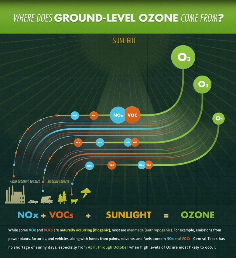
Odor Complaints Per 10,000
 County Odor Complaints6 Population7
 Residents
 Travis 486 1,273,954 3.81
 Williamson 151 590,551 2.56
 TOTAL 870 2,227,083 3.91

The total number of complaints in 2019 was much higher than the prior five years, when they ranged
from 371 – 476 per year. The number of complaints was sharply higher in Caldwell, Hays, Travis, and
Williamson Counties, ranging from 46% higher in Caldwell County to 140% higher in Hays County.
Bastrop County, on the other hand, had a 25% decrease in the number of odor complaints in 2019
compared to 2018, although it still has the highest number of complaints per capita – 93% higher than
the regional average. Overall, the increase in the number of complaints in 2019 pushed the region’s
number of complaints per 10,000 residents higher than the statewide average, as the figure below
shows.
Figure 1-14. Statewide and Austin-Round Rock-Georgetown MSA Odor Complaints per 10,000 Residents 2014 – 2019

 12
 Complaints Per 10,000 Residents

 10

 8

 6

 4

 2

 0
 2014 2015 2016 2017 2018 2019

 Bastrop Co. Caldwell Co.
 Hays Co. Travis Co.
 Williamson Co. Austin-Round Rock-Georgetown MSA
 Statewide

CAPCOG will discuss these trends with the CAC at its August 2020 meeting and seek direction on
whether they wish CAPCOG staff to spend any additional time further analyzing or investigating this
issue beyond summarizing these data in the annual report.

2 2019 Regional O3 Season Weekday NOX Emissions Profile
NOX emissions react with volatile organic compounds (VOC) in the presence of sunlight to form ground-
level O3. Depending on local conditions, an area’s O3 problems can be influenced more by NOX emissions
or VOC emissions. In the Austin metro area, NOX emissions account for about 99% of all locally-
generated O3. Therefore, understanding the contribution of different sources of NOX emissions to the
region’s typical daily NOX emissions during ozone season helps understand the relative importance of
these sources to O3 formation.

 Page 23 of 69
Figure 2-1. Ozone Formation

The following pie chart shows the estimated average 2019 O3 season weekday anthropogenic NOX
emissions in the region by major source type – on-road mobile, non-road mobile, point source, and area
source emissions.

 Page 24 of 69
Figure 2-2. 2019 O3 Season Weekday NOX Emissions for the Austin-Round Rock-Georgetown MSA (tpd)

 Total = 70.28 tpd NOX Emissions
 Area
 11.61
 17%
 On-Road
 24.38
 35%

 Point
 19.33
 27%

 Non-Road
 14.96
 21%

2.1 NOX Emissions by Source Type by County
Table 2-1 shows the break-down of the region’s ozone season day (OSD) weekday NOX emissions by
county and source type.
Table 2-1. 2019 OSD Weekday NOX Emissions by Source Type and County (tons per day)

 County On-Road Non-Road Point Area Total
 Bastrop 1.52 1.31 5.38 0.46 8.67
 Caldwell 0.86 1.04 0.94 1.89 4.73
 Hays 3.36 1.2 7.00 0.8 12.36
 Travis 13.14 7.69 5.84 6.47 33.14
 Williamson 5.5 3.74 0.17 1.99 11.40
 TOTAL 24.38 14.96 19.33 11.61 70.28

2.2 On-Road Sources
The on-road sector includes mobile sources that are registered to operate on public roads. On-road
vehicles remain the largest source of NOX emissions within the region, accounting for 24.38 tons per day
(tpd) of NOX emissions on a typical 2019 OSD weekday, based on TCEQ’s most recent “trends” emissions
inventories.8 Table 2-2 shows the typical 2019 O3 season weekday NOX emissions for the region by
source use type.

8
 Produced by TTI in August 2015. Available online at:
ftp://amdaftp.tceq.texas.gov/pub/EI/onroad/mvs14_trends/.

 Page 25 of 69
Table 2-2. 2019 Austin-Round Rock-Georgetown OSD Weekday NOX Emissions by Source Use Type (tpd)

 Source Use Type NOX
 Motorcycle 0.03
 Passenger Car 7.11
 Passenger Truck 4.99
 Light Commercial Truck 1.46
 Intercity Bus 0.14
 Transit Bus 0.20
 School Bus 0.39
 Refuse Truck 0.31
 Single-Unit Short-Haul Truck 1.54
 Single-Unit Long-Haul Truck 0.17
 Motor Home 0.16
 Combination Short-Haul Truck 2.98
 Combination Long-Haul Truck 4.90
 TOTAL 24.38

Passenger cars and passenger trucks combined to account for 12.10 tpd of NOX emissions, while heavy-
duty commercial trucking accounted for 9.91 tpd NOX emissions. The remaining sources accounted for
2.38 tpd NOX emissions, most of which come from light commercial trucks.

2.3 Non-Road Sources
The non-road sector consists of any mobile source that is not registered to be operated on a public road,
including sources such as agricultural equipment, construction and mining equipment, locomotives,
aircraft, and drill rigs. Non-road sources made up the 3rd-largest source of NOX emissions within the
region in 2019, accounting for 14.96 tpd of NOX emissions on a typical O3 season weekday. There are
four different types of non-road data sets: equipment modeled in the MOVES2014b and TexNv2 models,
locomotives/rail equipment, aircraft (including ground support equipment), and drill rigs.
Table 2-3. 2019 O3 Season Weekday Non-Road OSD Weekday NOX Emissions by County (tpd)

 County MOVES2014b Rail Aircraft Drill Rigs Total
 Bastrop 0.87 0.43 0.00 0.00 1.31
 Caldwell 0.54 0.46 0.02 0.02 1.04
 Hays 0.78 0.42 0.00 0.00 1.20
 Travis 4.88 0.43 2.38 0.00 7.69
 Williamson 3.19 0.52 0.02 0.00 3.74
 TOTAL 10.25 2.27 2.42 0.02 14.96

 • For MOVES2014b sources, CAPCOG used the 2017 OSD estimates prepared by TCEQ for the
 AERR,9 then adjusted the totals for each SCC and county based on the ratios between the 2019
 “Trends” inventory and the 2017 “Trends” inventory.10

9
 Available online here: ftp://amdaftp.tceq.texas.gov/pub/EI/nonroad/aerr/2017/for_EPA/
10
 Available online here: ftp://amdaftp.tceq.texas.gov/pub/EI/nonroad/trends/

 Page 26 of 69
You can also read