Applicazioni in campo geofisico per i dati acquisiti dal sensore iperspettrale ASI-PRISMA e analisi dei requisiti scientifici per le nuove ...
←
→
Page content transcription
If your browser does not render page correctly, please read the page content below
Applicazioni in campo geofisico per i dati acquisiti dal sensore
iperspettrale ASI-PRISMA e analisi dei requisiti scientifici per le
           nuove missioni ESA-SENTINEL e NASA-SBG

              Buongiorno M.F., Romaniello R., Silvestri M., Musacchio M., Spinetti C.

                    Istituto Nazionale di Geofisica e Vulcanologia, Roma, Italy

                                  Congresso Nazionale SIF 14-18 Settembre 2020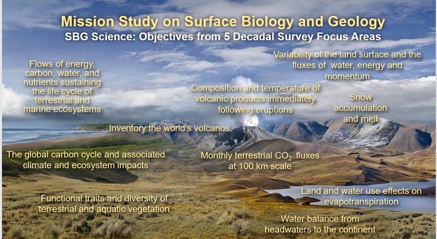
OVERVIEW
• ESA SENTINEL MISSIONS AND NEXT GENERATION
• ITALIAN CONTRIBUTE FOR OPTICAL MISSIONS
• INGV PRELIMINARY EVALUATION OF PRISMA DATA TO STUDY
  VOLCANIC PHENOMENA.
• ASI-JPL JOINT COOPERATION FOR THE NASA-SBG MISSION
• CONCLUSIONS

                     Congresso Nazionale SIF 14-18 Settembre 2020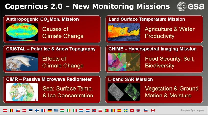
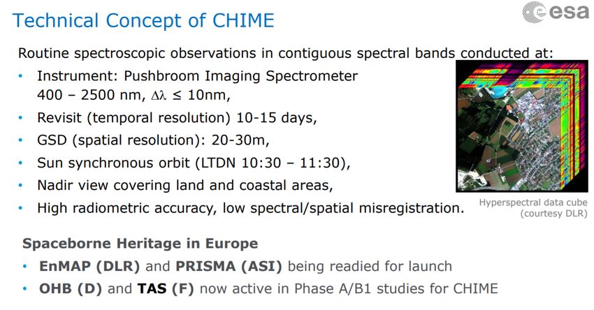
ESA NEW MISSIONS TO STUDY EARTH
In the last 2 decades a gigantic increase of space data have been acquired mostly at no cost for scientific
and applicative communities
ESA earth observation missions program and sentinels for eu-copernicus services are very successful example
6 new ESA monitoring missions are under study in esa ingv is currently working in the chime and land
surface temperature missions

                                         Congresso Nazionale SIF 14-18 Settembre 2020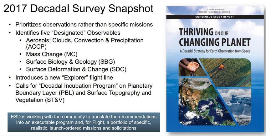
Congresso Nazionale SIF 14-18 Settembre 2020
MAIN CHARACTERISTICS FOR FUTURE THERMAL MISSIONS

                 Congresso Nazionale SIF 14-18 Settembre 2020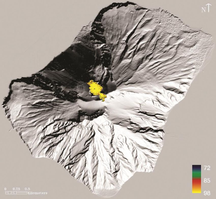
ITALIAN CONTRIBUTE TO NEW EO MISSIONS
       WITH OPTICAL INSTRUMENTS

  The Italian Space Agency is implementing an articulated plan to support
  new EO missions which includes: instruments, satellite platforms,
  launchers and ground segment.

  FOCUS ON OPTICAL MISSIONS
  • HYPERSPECTRAL MISSIONS
  • THERMAL INFRARED MISSIONS

                           Congresso Nazionale SIF 14-18 Settembre 2020
PRISMA: PRecursore IperSpettrale della Missione Applicativa
Messa in orbita il 22-Marzo-2019
National EO hyperspectral Mission fully funded by ASI.
Realized by Italian Industries Consortium led by OHB Italia,
Leonardo and Telespazio
Mission conceived as a Pre-operational and technology
Latitude 70°S ÷ 70°N
demonstrator, with focus on
Space qualification of PAN/HYP payload
Development of PAN/HYP products up to Level 2D (BOA
geocoded reflectance) Longitude 180°W ÷ 180°E
PRISMA sensor operates in Pushbroom scanning mode Primary mode – Manage user requests
• CALVAL sites (highest priority)
Records the radiation reflected from the Earth surface
• Nominal requests from all registered users, subject to
(spectral cubes) in 400nm – 2505nm spectral window
quota and a priority level (depends by the user type)
240 total bands in VNIR (#66, 400–1010 nm) & • Mission Manager can promote Nominal Requests already
SWIR (#174, 920–2505 nm), partial spectral Accepted to Very Urgent, for insertion in next day plan
overlap
Background mission – Optimize system resources usage
High spectral Resolution (better of 14 nm) • Generated to fill-up resources still available after planning
Medium spatial resolution (30m) and swath (30km) of users requests or for systematic acqusitions
PAN camera offers added capability with 5m resolution
7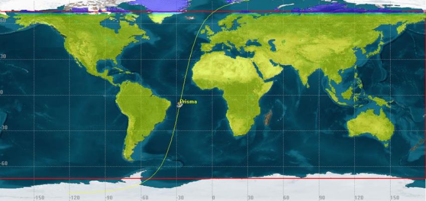
PRISMA MAIN CHARACTERISTICS

       Congresso Nazionale SIF 14-18 Settembre 2020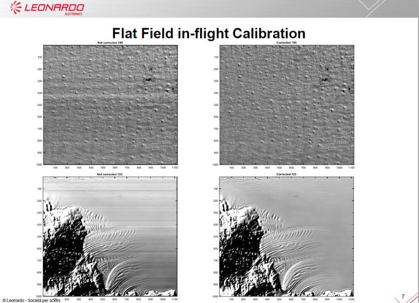
Radiometric Calibration

 Congresso Nazionale SIF 14-18 Settembre 2020
In-flight Flat field Calibration using PICS and Radiance

                   Congresso Nazionale SIF 14-18 Settembre 2020
PRISMA DATA INFORMATION AND ACCESS
https://www.asi.it/en/earth-science/prisma/
To access the data You need to create an account which permits to access
the PRISM archive and submit requests for new acquisitions
https://prisma.asi.it
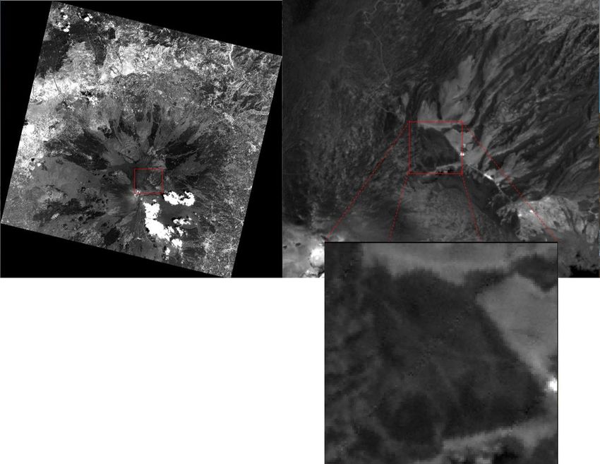
Congresso Nazionale SIF 14-18 Settembre 2020ANALYSIS OF PRISMA DATA OVER CAL/VAL SITES IN VOLCANIC AREAS
INGV IS PRT OF THE PRISMA ADVISORY BOARD (PAGE) AND STARTED TO EVALUATE THE DATA QUALITY AT THE
PRISMA image acquired sul piano
delle Concazze (Mt. Etna)
31 July 2019
Piano delle Concazze area is located
at 3000 m asl with a very homogenous surface
DEM
Congresso Nazionale SIF 14-18 Settembre 2020APPLAY ATTMOSPHERIC CORRECTION TO RETRIEVE GROUND
REFLECTANCE
A. The sun radiance that reaches directly the pixel
Retrieval of ground reflectance using atmospheric correction viewed by the sensor (target) and that is
directly reflected by the target to the sensor;
procedure based on S6 and MODTRAN B. The sun radiance that reaches directly the pixel
viewed by the sensor (target) and that is
reflected by the target to the sensor following a
multiple scattering path;
C. The sun radiance that reaches the target
following a multiple scattering path and that is
directly reflected by the target to the sensor;
D. The sun radiance that reaches the target
G A-B-C-D-E-F following a multiple scattering path and that is
reflected by the target to the sensor following a
multiple scattering path;
E. The sun radiance that directly reaches the
surface surrounding the target and that is
reflected by the surface to the sensor following
a multiple scattering path;
F. The sun radiance that reaches the surface
surrounding the target following a multiple
scattering path and that is reflected by the
surface to the sensor following a multiple
scattering path;
G. The sun radiance that is directly scattered by
the atmosphere to the sensor without reaching
the ground.
All of these terms, with the exception of G),
are also influenced by the orientation of the
surface with respect to the sun illumination
direction.
Congresso Nazionale SIF 14-18 Settembre 2020Piano delle Concazze has been used for CAL/VAL activities and INGV has a
reflectance history based over 10 years of Hyperion acquisitions
The maximum difference among the spectra is about 5%
The RED curve is the average of 9 years of sensed images obtained
collecting 120 pixels per image: about 2300 spectra
Band Number
Congresso Nazionale SIF 14-18 Settembre 2020Comparison of PRISMA/Hyperion reflectances and ground truth on
Piano delle Concazze
Intervallo Hyperion FieldSpec PRISMA FieldSpec
spettrale convolved on convolved on
(µm) Hyperion PRISMA
0.4 - 0.9 0.0376 0.0425 0.0492 0.0419
(VNIR)
1.0 - 1.3 0.0363 0.0379 0.0460 0.0378
(SWIR)
1.5 - 1.8 0.0400 0.0397 0.0519 0.0397
(SWIR)
2.0 - 2.4 0.0423 0.0453 0.0645 0.0454
(SWIR)
Congresso Nazionale SIF 14-18 Settembre 2020Volcanic CO2 mapping using SWIR channels
CO2 absorption lines are present in the spectral range of hyperspectral imaging
spectroradiometer VNIR-SWIR
weak absorption 1270 nm and 1610 nm
strong absorption 1950 nm and 2100 nm
Atmospheric transmisson
simulated using Modtran
with the only presence of CO2
in standard condition with 10
nm of spectral resolution
Congresso Nazionale SIF 14-18 Settembre 2020The CIBRW retrieval alghoritm
In order to retrieve the tropospheric volcanic plume Carbon Dioxide abundance, an inversion technique has
been developed for remote sensing hyperspectral data (Spinetti et al., 2008, RSE). The algorithm is based on
the assumption that there is a relationship between the dip in the atmospheric spectrum curve, due to the gas
absorption, and the gas concentration in the atmospheric column. The retrieval is based on solving the equation:
β(w)
CIBRW exp(α(w) CO )
2
- [CO2] is the unknown carbon dioxide columnar abundance (kg·m-2);
- e parameters related to the model variables, volcanic water vapor abundance and
volcanic aerosol presence;
- CIBR is given by the following ratio:
R
CIBR a
AR BR
1 2
- Ra is the radiance corresponding to
the minimum of absorption
- A and B are the weighting constants
- R1 and R2 are the radiances of the
continuum
Congresso Nazionale SIF 14-18 Settembre 2020AVIRIS (Airborne Map of CO2 abundance in the
Visible/InfraRed Pu’o’O Vent plume
Imaging Spectrometer)
NASA-JPL
DATA
Pu’o’O, Hawaii
FCO2 = 396±138 t d−1
Accordance with ground
sampling data
Image acquired
26-April-2000
Congresso Nazionale SIF 14-18 Settembre 2020Retrieval of Carbon Dioxide from Radiating source
CO2 map emitted by active summit craters obtained with CIBRW technique on airborne
hyperspectral images acquired on Stromboli in 1997.
CO2 map @ 3 m res
Flight level 11500 ft 3.5 km
Congresso Nazionale SIF 14-18 Settembre 2020FIRST EVALUATION USING PRISMA DATA FOR CO2
mapping using SWIR channels
PRISMA RADIANCE SPECTRUM TO EVALUATE CO2
DETECTION
Congresso Nazionale SIF 14-18 Settembre 2020NASA NEW SCIENTIFIC MISSIONS TO STUDY EARTH ARE BASED ON
THE LAST DECADEL SURVEY 2017
(https://essp.nasa.gov/essp/files/2018/02/2017-Earth-Science-Decadal-Survey.pdf)
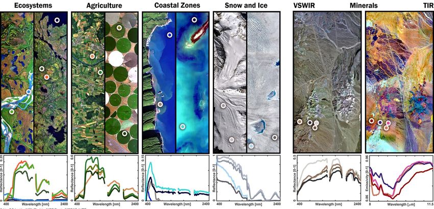
Congresso Nazionale SIF 14-18 Settembre 2020SBG Science across five focus area and two
critical spectral regions
Congresso Nazionale SIF 14-18 Settembre 2020THE MISSION SURFACE BIOLOGY AND GEOLOGY (SBG)
will respond to many Science Objectives
Congresso Nazionale SIF 14-18 Settembre 2020Joint ASI-NASA-JPL joint mission study for NASA-SBG mission
in July 2018, the Italian Space Agency (ASI) and NASA-Jet Propulsion Laboratory (JPL)
started a joint study to define a new TIR free-flyer mission concept.
ASI and JPL considered a number of previous studies performed in the past,
including the following: HyspIRI TIR free-flyer, MTISS (2011) and TMAX study EE9
2017.
The present mission study carried out by the Joint team of ASI, JPL, INGV, INAF
scientists has the aim to develop a very challenging space mission to respond to the
observation requirements expressed by a very large scientific community.
Congresso Nazionale SIF 14-18 Settembre 20206.5 hours per day of science data Congresso Nazionale SIF 14-18 Settembre 2020
Involvement of the Italian Scientific Community for mission
                        requirements

The contribute of the Italian Scientific Community is fundamental to:
• Acquire information on the application that requires MWIR-LWIR
  observations
• Support the correct development of the MWIR-LWIR mission
• Explore opportunities for the international cooperation
• Networking opportunities for the national scientific community in EO
  issues

During 2018-2019, ASI and INGV organized two workshops to involve the
Italian Scientific Community to acquire of the scientific and observation
requirements for a MWIR-LWIR space sensor Information and
presentation on the ASI-INGV workshops are available at
https://www.asi.it/event/mwir-lwir-mission-study/.
                            Congresso Nazionale SIF 14-18 Settembre 2020
The ASI-JPL mission study consider a SWIR-MWIR-LWIR sensor with 8 spectral
channels and 1 VNIR camera with 2 spectral channels (Baseline)
Congresso Nazionale SIF 14-18 Settembre 2020VNIR camera under study (INAF coordinator)
has 1 channel in the VIS and I channel in the NIR are selected in order to produce NDVI maps
for assessing vegetation coverage and characteristics
Hyperion spectral profile on vegetation
Congresso Nazionale SIF 14-18 Settembre 2020
and RF’s for testingSBG TIR mission study may contribute to measuring CO2
Emissions from point soureces using the absorption band at 4.8
µm
MWIR channels: estimate CO2 emissions
from fires, volcanoes and industrial
pants is of high interest, the 4.8 µm, in
the MWIR spectral range, has been
investigated by means of model
simulations to evaluate the radiometric
requirements to measure different
columnar concentration of CO2
Congresso Nazionale SIF 14-18 Settembre 2020Sensitivity to the CO2 concentration
EXP1 - EXP6: T=300 K; CO2 = 0-1000 ppm (step 200 ppm)
Congresso Nazionale SIF 14-18 Settembre 2020Channel sensitivity to CO2 concentration and surface temperature
First simulations analyses provide NEDT (K)
T=300 K T=400 K T=500 K T=600 K
required
information on NEDT required for For 10 ppm abv bkg < 0.046 < 0.095 < 0.150 < 0.211
the carbon dioxide retrieval by For 20 ppm abv bkg < 0.092 < 0.189 < 0.300 < 0.422
employing the 4.8 µm channel with For 30 ppm abv bkg < 0.139 < 0.283 < 0.450 < 0.632
a FWHM=0.15 µm For 40 ppm abv bkg < 0.185 < 0.377 < 0.600 < 0.842
For 50 ppm abv bkg < 0.230 < 0.471 < 0.750 < 1.052
For standard and intermediate temperatures
NEDT (K)
T=700 K T=800 K T=900 K T=1000 K
required
For 10 ppm abv bkg < 0.285 < 0.368 < 0.459 < 0.558
For 20 ppm abv bkg < 0.570 < 0.736 < 0.917 < 1.116
For 30 ppm abv bkg < 0.854 < 1.103 < 1.375 < 1.673
For 40 ppm abv bkg < 1.138 < 1.470 < 1.833 < 2.231
For 50 ppm abv bkg < 1.422 < 1.837 < 2.289 < 2.787
For high temperatures
Congresso Nazionale SIF 14-18 Settembre 2020CONCLUSIONS
• In the next decade new satellite optical mission will be available to
the scientific community
• Is very important to improve the capability to process large data
volume acquired by hyperspectral and TIR sensor on satellite and
consolidate retrieval algorithms to monitor Earth process and human
activities
• Is also important to promote the international collaboration to share
scientific goals and scientific and operational requirements for new
satellite missions.
• Finally the prepare and train the new generation of space scientists
Congresso Nazionale SIF 14-18 Settembre 2020Acknowledgements
• I would like to thank:
• all INGV collegues for their high quality research using hyperspectral
and thermal data.
• ASI and ESA for the support in the hyperspectral and TIR studies and
organization of thematic workshops
• NASA-JPL for the long collaboration in developing new missions
• and many other colleagues from Research Institutes, Universities and
Industries of the space sector
Congresso Nazionale SIF 14-18 Settembre 2020Congresso Nazionale SIF 14-18 Settembre 2020
You can also read