Assessing Late Antique Villa Transformation at Individual Sites: Towards a Spatial Approach
←
→
Page content transcription
If your browser does not render page correctly, please read the page content below

Dodd, J. 2021. Assessing Late Antique Villa Transformation
                                                              at Individual Sites: Towards a Spatial Approach. Theoretical
                                                              Roman Archaeology Journal, 4(1): 3, pp. 1–28. DOI: https://
                                                              doi.org/10.16995/traj.4336

Assessing Late Antique Villa Transformation at
Individual Sites: Towards a Spatial Approach
James Dodd, VU Amsterdam, NL, j.a.l.d.dodd@vu.nl

This paper builds on the methodology for assessing the transformation of Roman villas in Late
Antiquity. Previous studies have moved from simple identification towards a more holistic way of
spatially visualising transformation (for example, Chavarría 2007; Dodd 2019) however, none of
these previous attempts have led to a spatially comparable approach to site transformation across
different regions and individual settlements. This paper will lay out the problematic nature of spatially
illustrating villa transformation and address the development processes of prior studies. It will lay
out the conceptual framework for a new approach to addressing villa transformation based on three
spatial layers and demonstrate their applicability on two important villa complexes in Northern
Britain and the German Saarland.

Theoretical Roman Archaeology Journal is a peer-reviewed open access journal published by the Open Library of Humanities.
© 2021 The Author(s). This is an open-access article distributed under the terms of the Creative Commons Attribution 4.0
International License (CC-BY 4.0), which permits unrestricted use, distribution, and reproduction in any medium, provided
the original author and source are credited. See http://creativecommons.org/licenses/by/4.0/.
 OPEN ACCESS
2

    Introduction
    The transformation of the Roman villa during Late Antiquity has been a key focus of
    scholarship and remains an important aspect for understanding the transition from
    the Roman to the Early Medieval period. Between the third and sixth centuries AD, rural
    communities across the Western Roman Empire experienced widespread dislocation
    as social and economic patterns changed, and this shift is archaeologically visible in
    the development of new productive practices and habitational styles at individual villa
    complexes. This transformation has been investigated over the last two decades via new
    conceptual and theoretical approaches (Ripoll and Arce 2000; Lewit 2001; Chavarría
    2004, 2007; Christie 2004; Dodd 2019 to name a few), which carry an understanding
    that such villa transformation represents a structural change in the Roman rural
    landscape rather than a phase of little or no consequence.
       These theoretical approaches have been complemented by the collection of data
    from multiple sites in both a large-scale, non-systematic way, picking well-excavated
    or well-known sites from different diverse regions (Lewit 1991; Chavarría 2007), as
    well as on a systematic regional level (Van Ossel 1992; Gandini 2008; Dodd 2014;
    Dodd 2020), attempting to build detailed regional snapshots of villa transformation.
    In particular, there has been widespread regional analysis of the Iberian Peninsula,
    Northeastern Gaul, Britain, Southeast Gaul, and Italy (Van Ossel 1992; Réchin 2006;
    Heijmans and Guyon 2007; Schneider 2007; Brogiolo and Chavarría 2008; Castrorao
    Barba 2014; Dodd 2014; Raynaud 2018) and such data collection has expanded our
    understanding of rural change in the Latin West. We are now able to say that villa
    transformations occurred in every region of the Western Empire, with the possible
    exception of North Africa.
       This increased interest in Late Antiquity over the last three decades has sketched
    out the scope and shape of rural change and has identified it as a key element to the end
    of the Roman socio-economic structure in the countryside. Traditionally, this change
    was labelled ‘squatter occupation’ and dismissed as a phase of no consequence or as
    the product of barbarian groups unable to comprehend the correct use of Romanised
    features such as bathhouses (cf. Payne 1897: 69; García Gelabert and García Díez
    1997: 53; Lewit and Chavarría 2004: 3–4). This biased view has drastically restricted
    our understanding of change within villa complexes, and it is only since the 1970s
    that attitudes have begun to shift away from the simplistic narrative of ‘decline and
    fall’. This older narrative supported a pessimistic interpretation of transformational
    trajectories as the work of ‘squatter’ living in the ruins of the classical past (cf. Petts
    1997: 103–105; Lewit 2001: 261–262; Lewit 2005 251–252). The changing nature of the
    academic consensus away from the narrative of ‘decline and fall’ has shifted the study
3

of villa transformation from a dismissive one to a more nuanced view that sets villa
transformation contextually within a change of the Roman socio-economic milieu.
   Two concepts require definition for this paper: villa and villa transformation. Both
have been subjected to vast amounts of literature in the past 50 years and there are a
wide variety of views, opinions, and standpoints on both. This paper does not seek to
readdress these terms but rather introduce an effective methodology for assessing villa
complexes in their final occupation trajectories.
   The word ‘villa’, originating from the Latin moniker villa rustica, referred to any
rural residence and is poorly defined, even in ancient sources (for example, Cato, De
Agricultura 1.4.1; Varro, Res Rusticae 3.2.10; see also Rivet 1969: 178–179; Percival 1976:
14 –15 for modern perspectives). Over 150 years of excavation and analysis have further
confused and misrepresented this Latin word despite the large body of literature
dedicated to definitions and redefinitions, conceptual and theoretical approaches, and
practical discussions (Percival 1976: 14–15; Habermehl 2014: 17–18 to name a few). The
situation has been well summarised by Willems (1981: 112): ‘exactly what constitutes
a Roman villa is a subject that will probably be debated forever’. Archaeologically,
the term has been considered too important to reject outright and has subsequently
been broadly applied to many rural dwellings demonstrating some form of Romanised
occupation. Such an approach seeks to use the term ‘villa’ whilst ignoring the
significant literary issues/analogies present in the sources (Dark 2005) and represents
a solely morphological standpoint. Naturally, this has resulted in the term being
applied to any rectangular dwelling, especially in the northwest provinces (Percival
1976: 13; cf. Habermehl 2014: 17–18). Modern approaches to this have generally been
divided in two: a historical-interpretative model rooting villas in an ‘Italic model’ of
development (Rivet 1969: 178–182; Percival 1976:119 –144; cf. Slofstra and Brandt 1983:
87) and an archaeological model viewing villas from within a landscape-archaeological
perspective (cf. Hingley 1989: 3; Roymans and Derks 2011: 1–4). These perspectives have
spurred the development of socio-cultural definitions and abstract models (Hodder
and Millett 1980; Slofstra and Brandt 1983) that use these socio-economic associations
and presumptions as the defining characteristics of a villa.
   This paper will approach the term archaeologically, utilising a more practical
morphological framework, similar to previous studies examining villa transformation
(for example, Van Ossel 1992: 39–44; Lewit 2001: 260; Chavarría 2007: 32–36). The
defining characteristics of a villa complex are relatively simple. Architecturally, it
requires some degree of monumentalisation. Construction in stone is a primary
element, at least for the main house, and must be supplemented by non-functional
(by which is implied luxury elements) internal or external features. These features
4

    can include but are not necessarily limited to the hallmarks of Roman architecture
    and include hypocausts, baths, mosaics/tessellated pavements, and luxury decoration
    such as marble, statuary, fountains, or other ornamental features. This framework also
    assumes that these buildings were probably owned by the upper strata of rural society
    or, at the very least, their agents. In the majority of cases, these complexes comprised
    an estate centre with one or several monumentalising buildings and a series of ancillary
    production, storage, and processing structures. In short, the villa is being defined as
    the main house of an estate centre, of which one building or more must exhibit some
    form of luxury features indicating a degree of investment of surplus disposable capital
    into landed assets (Hingley 1989: 45–46).
       The second key concept revolves around the various activities grouped as ‘villa
    transformation’. Although all villas underwent a constant form of transformation
    (for example the early development explored in Habermehl 2014), when used in a Late
    Antique context it often refers to the archaeologically visible shift in production and
    habitation at Roman villas that appears between the third and sixth centuries AD (see
    Petts 1997: 102–103; Christie 2004: 8–27). As such, the term ‘villa transformation’
    represents a more nuanced and less biased approach than the previously used ‘squatter
    occupation’ (Gerrard 2013: 165). Archaeologically, it is physically represented by
    haphazard uses of living space as well as the use of buildings for mortuary purposes
    and productive zones (for example, Dodd 2021). This is often coupled with the radical
    reorganisation of sites: partial abandonments and conversions are key components
    of villa transformation. Newly built structures on such sites often disregarded the
    orientation of older buildings and have consequently been viewed as ‘messy’, reusing
    older building material as spolia or building in a perceived poor-style from new,
    perishable material such as wattle and daub or timber (Petts 1997: 103–105; Lewit 2001:
    261–262; Lewit 2003: 251–252). Within the framework of this paper, the larger unwieldy
    definition of villa transformation is broken down into smaller, more manageable
    classifications that allow for statistical comparisons. Since the early 1990s, varying
    classification systems have been applied to transforming villa complexes (Van Ossel
    1992: 127–142; Ripoll and Arce 2000: 70–95; Chavarría 2004: 76–85; Castrorao Barba
    2014: 261–262). This paper will utilise the system laid out in Dodd (2019) which divides
    transformation into five separate categories: habitational transformation, productive
    transformation, cultic transformation, funerary transformation, and fortification
    transformation (see Table 1).
       There are several further issues to consider. The use of surrounding space, such as
    courtyards or the periphery of buildings, is a difficult concept to identify spatially. These
    zones play an important role in the transformation of villa complexes as they are often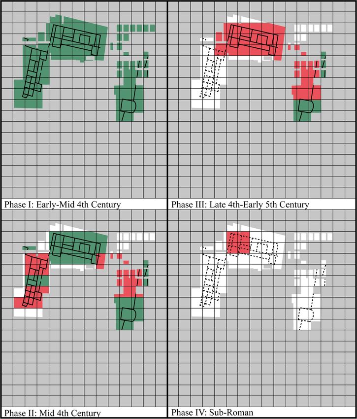
5
Class of Archaeological Features Material Culture
Transformation
Habitational postholes, pits, hearths, new floors, wood domestic pottery, refuge
constructions, subdividing walls, middens, and waste deposits, organic
huts, Grubenhäuser. material deposits.
Productive grain driers, threshing floors, metalworking Industrial quantities of
smelters, smithing hearths, oil/fish pro- pottery or industrial waste,
duction facilities, saltworks, water tanks, e.g. metalworking slag,
batteries of dolia, kilns. semi-finished products.
Funerary any form of burial, either individually or grave goods, human
grouped. remains.
Cultic chapels, oratories, and baptisteries. wall plaster with Christian
Often only discernable by overt Christian motifs, overt Christian
evidence. architectural elements.
Fortification burgi, defended enclosures, Speichertürme, N/A
fortified compounds.
Table 1: A breakdown of the applied transformation classification system and associated feature
types (after Dodd 2020: 36, Table 2.4).
utilised for the construction of new styles of occupation, for example, at Neerharen-
Rekem (De Boe 1982). Despite this important role, assessing them spatially has proven
difficult. This paper will assume that such zones remained in some form or use, either
for access or simply for dumping material and, thus, the methodology laid out here will
root outside spaces within the grid system in order to integrate the analysis of space
and time across the selected sites.
The key problem for making a tangible assessment of the impact of villa
transformation on both a comparative regional level and on the level of the individual
site is the lack of a cohesive and comparative framework for spatial analysis. Regional
studies incorporating multiple sites have demonstrated that comparisons between
sites, or groups of sites, based on common transformational characteristics yields
results on a large scale (Van Ossel 1992; Chavarría 2007; Dodd 2014). Despite this,
there has been little investigation into how individual sites can be compared within
a larger framework. There is no standardised methodology for the assessment of
transformation at individual sites, resulting in the application of various methods. The
approach laid out in this paper will develop a standard comparable method for assessing
change at different sites. This will both counterbalance the increasing push towards
the development of regional studies as well as complement it. Comparable site phasing
plans provide individual sites with a biography and development sequence beyond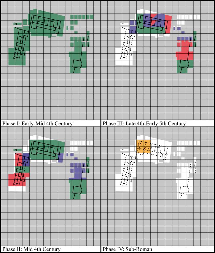
6

    simple classifications and creates a basis for statistical comparisons between multiple
    villa complexes based on a series of common variables. Equally, it is worth highlighting
    that the methods employed on villas in this paper could potentially be used at other
    classes of rural sites, such as farms and sanctuaries, and are not solely dependent on
    the classification of a site as a villa.

    Conceptual Framework and Previous Work
    Methodologically, this paper focuses on two main strands: the identification of
    transformational contexts and the breakdown of transformation into constituent classes
    and typologies. The identification of transformational contexts within villa complexes
    has a long history. The first recognition of the secondary use of features appears in
    the middle of the nineteenth century (for example Luard 1859) and scholarship is now
    relatively advanced in the identification of transformation at individual villa sites. There
    is now a corpus of good-quality evidence published from a range of villas across the
    Latin West and the transformation of the Roman villa is a key part of the archaeological
    narrative (for example, Pomarèdes, Barbaran, Maufras and Sauvage 2012; Blom van der
    Feijst, and Veldman 2013; Willis and Carne 2013; Henrich 2017). The second strand in
    the conceptual framework behind this study is the assessment of villa transformation
    by a classification system. Classification systems have been in place since the
    beginning of modern engagement with wider villa transformation in the early 1990s
    (Lewit 1991; Van Ossel 1992: 127–142) with regionally focused and underdeveloped
    conceptual approaches common (Ripoll and Arce 2000: 70–95; Chavarría 2004: 76–85;
    Castrorao Barba 2014: 261–262). Further developments have led to more complete and
    methodologically rigorous classification systems (Chavarría 2007: 163; Dodd 2019).
    Generally, these studies have tended to deconstruct transformation into several broad
    categories: productive, habitational, cultic, and funerary transformation (laid out
    in Table 1) and this study will work within this convention when spatially assessing
    change at Late Antique villas.
       Despite plenty of work directed towards the development of methodologies to
    classify transformation and to identify transformational deposits in the archaeological
    record, there has been little or no work towards developing a comparable spatial
    methodology for assessing change on individual sites at a comparable level. The spatial
    assessment of transformation on individual sites has long been problematic. Initially,
    excavation reports tended to describe change on a room-by-room basis, assigned by the
    presence of transformational contexts (for example, Payne 1897; O’Neill 1933; De Boe
    1974). Although somewhat effective in isolating change within buildings, this approach
    did not effectively assess zones outside buildings. Traditionally, archaeological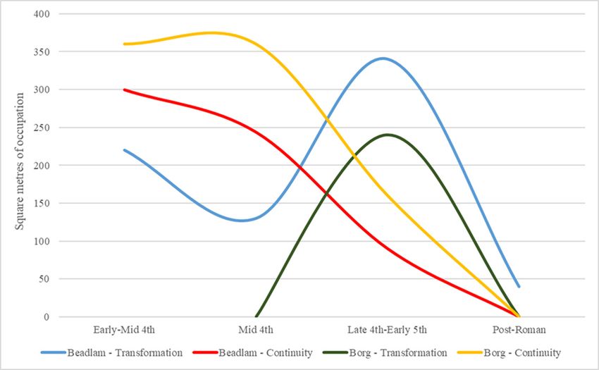
7

investigation of villas focused on the main building of a villa complex (Roymans and
Derks 2011: 9–11), an issue that adds another problematic layer to attempts to plot
transformation spatially at villas. This approach was prevalent in excavation reports
until the 1980s. From the mid-1990s onwards, there was a significant shift in this
approach. New studies, synthesising large amounts of data, began to present data along
with excavation plans (Lewit 1991; Van Ossel 1992). The inclusion of plans in regional
studies did not necessarily mean these plans were actively used in providing spatial
data on individual sites. The use of plans in this way appeared in the early 2000s when a
rudimentary system of spatial analysis was developed by highlighting zones of known
transformation on original site plans. This was undertaken both as part of large-scale
region studies (for example Chavarría 2007) and in more general syntheses (Ripoll and
Arce 2000; Lewit 2003, 2005). This new approach towards identifying transformation
(Figure 1a and 1b) was pioneered before the widespread adoption of digital illustration
techniques. This difficulty was supplemented by a distinct lack of phasing trajectories,
with illustrations of change at villa sites representing either multiple periods on one
plan or a singular point in the occupational trajectory at a site.
   Naturally, this presents a very one-dimensional picture of transformation at
selected sites. The natural progression of these representations was the development
of highly schematic plans, incorporating developed site phasing plans based on a
close reading of site reports (Dodd 2019: 39–40; Dodd 2020). These plans (Figure 1c)
utilised a colour scheme to isolate different forms of transformation for multi-regional
statistical analysis (laid out in Table 3) and represented a step in the right direction in
the comparison of transformational trajectories between varied sites. Despite this leap
forwards, significant issues remained with the new system. There was little attempt to
assess zones outside buildings and statistical comparisons between sites tend to rely
on transformation room totals rather than more holistic variables.
   The previous work laid out above represents the current state of spatial approaches
towards villa transformation. Secondary to this, all previous studies have failed to
develop spatial analysis systems that effectively integrate sectoral or zone abandonment
into plans. Abandonment is a key element in the transformation of villa settlements
across the Latin West and has a key role in the trajectories taken by individual
sites. However, the primary focus of the study of rural change has been to divorce
transformation from abandonment (Van Ossel 1992: 79–84; Christie 2004: 21–23).
The trend in Roman archaeology has been to repeatedly brush over the desertion of
sites, preferring to view abandonment as a linear process ending up in the complete
disuse of a site and its entry into the archaeological record (see Schiffer 1987: 89 for
the key definitions). Methodologically dividing transformation and abandonment is
8

    Figure 1: Three examples of previous attempts to display transformational data at villa complexes:
    a. El Ruedo (Lewit 2005: 252, Fig. 1, reproduced with permission of Cambridge University Press),
    b. Vilauba (Chavarría 2007: 171, Fig. 35, reproduced with kind permission of Quim Tremoleda
    Trilla), c. Beadlam (Dodd 2020).
9 no longer a useful concept. Unifying the two into an overarching framework would allow for the development of a more holistic understanding of purpose, activity, and trajectories at individual sites without assuming that abandoned zones were entering the archaeological record separately from utilised structures. Methodology The methodology proposed here presents an advance on previous attempts to represent villa transformation spatially. The method of analysis is relatively simple; however, its application across different sites will yield significant benefits in the statistical investigation of transforming villa settlements by providing a system that allows each site to be placed within a comparative framework. The new method proposes the creation of a scaled grid system for each site in order to provide a statistically accountable method for comparison. Quadratic grid systems are commonplace on modern archaeological plans and have long been used in survey archaeology (cf. Keller and Rupp 1983; Tartaron 2003), although this is not always the case and many published plans do not include a grid system. This method imposes grid systems on site plans, in increments of 10 metres; however, given the erratic nature of recording and planning, there will be significant variability in this from site to site. The use of 10 metre increments are key to establishing comparative parity and can be scaled up or down depending on the quality of the dataset, with the incremental scale allowing relative ease of comparison based on the multiples of the same number across different sites. This flexible system allows for both poor-quality and higher-quality data to be integrated into the analysis. This means that poorer-quality sites can be viewed at a lower resolution, yet still can provide important information on their spatial trajectories and, therefore, can be compared with other sites on a similar level. Although many excavations are of extremely poor quality, an incremental grid system, combined with a resolution system (Table 2) can be used to integrate these sites into larger statistical analysis, with the test example of Borg demonstrating that a re-examination of poor-quality data can yield results. Naturally, the creation of a site grid allows zones to be marked as ‘unknown’ (see Table 3), giving a degree of flexibility to plans and opening site plans up to the incorporation of future work or final publications. This grid system presents a basis for the application of a system of three thematic layers at individual sites: a macro-level view, a low-resolution view, and a high-resolution picture (Table 2). These three layers are expressed within the grid framework and are coupled with a temporal trajectory (cf. Dodd 2019: 39–40), dividing each site down into periodisations based upon shifting patterns in the trajectory of each site.
10
Thematic Layer Resolution Level Practical Application
Layer 1 Macro-level view Identification of site activity
Layer 2 Low-resolution Identification of transformation categories
transformation
Layer 3 High-resolution Identification of sub-types of transformation, features,
transformation and contexts (where applicable)
Table 2: The resolution system utilised in this methodology, laid out with the practical considera
tions in its construction (J. Dodd).
Transformation Type Colour Scheme
Habitational Red
Productive Blue
Funerary Orange
Cultic Yellow
Occupation without transformation Green
Non-Excavated Area Grey
Unknown Brown
No information available White
Abandoned Structure Dotted Line
Table 3: Breakdown of colour scheme used in this methodology (J. Dodd).
The first layer is a macro-scale picture of a site. This layer of analysis separates zones
of known activity on-site and illustrates the broad trajectory of changes experienced
in Late Antiquity at villa sites within the framework of an occupational trajectory.
It introduces a binary layer of activity at villa sites: transformation or continued
occupation in a more traditionally Romanised style. This layer also integrates options
to display the abandonment of specific features and buildings. It suggests the use of
dotted lines to demonstrate buildings ‘no longer in use’, but the overlying grid system
still allows for the utilisation of some of these buildings for secondary purposes, such
as waste dumping or stone robbing.
The second layer provides a more expansive examination of the transformational
trajectory of any given site. This low-resolution view of transformation utilises
the quadrants of the grid system to isolate and identify different classifications of
transformation on-site. This presents a useful way of spatially analysing different uses11 of sectors of the site. In some cases, for example, at Beadlam in Northern England (Neal 1996), multiple forms of transformation are present in one grid square (see Figure 4). In cases such as this, a low-resolution view of transformation will divide the grid square equally between the appropriate colours to represent multiple forms of transformation. This layer is an adapted form of phasing plan that has been trialled in previous studies and is employed in a large-scale study of villa transformation (Dodd 2020). The adapted form presented in this methodology provides a more comprehensive and statistically responsive way of measuring and comparing transformation. The final layer presents a high-resolution picture of transformation at a site and a detailed view of its transformational trajectory in Late Antiquity. This layer expands upon the low-resolution picture of transformation by sub-dividing the types of transformation laid out in Table 3 into further divisions based upon the types of activity within given classes; for example, metalworking or agricultural processing form elements of ‘productive transformation’. This presentation of specific sub-types of activity is laid out on the site plan on a zone-by-zone basis, disregarding the larger- resolution use of quadrants. Instead, it highlights change by the actual use of areas, based on the material culture and stratigraphy laid out in site reports, for example, highlighting rooms used for metal processing. In the case of some well-excavated sites, this layer of resolution may be displayed on the level of individual transformational features and deposits on a site, yet in the majority of cases, this will not be possible due to the nature of site recording processes. Naturally, the state of publication and the recording processes operating at each site influences the development of high-resolution pictures (layer 3) of transformation. In the majority of cases, it is difficult to reconstruct the top-tier resolution grids for sites. Despite this, the flexibility of this system enables most sites to be constructed at a low-resolution picture, allowing activities to be compared. Some sites may only be able to present layers 1 and 2, or in some cases, only layer 1. This versatility allows the system to act in a flexible manner to incorporate a wide variety of sites, all of which are excavated at different resolution levels. The most pressing problem of this method is the problematic role of transformation ‘intensity’. Measuring the intensity of transformational deposits has always been a key issue for developing coherent narratives of change for individual villa settlements and has resulted in a distinct lack of site trajectories. Problematic and highly diverse site excavation and recording means that developing a scale for measuring intensity similar in scope to systems utilised in survey archaeology is nearly impossible. Consequently, this methodology has somewhat sidestepped the issue, focusing on the spatial- temporal layout of transformation rather than the perceived intensity of occupation
12

     at individual sites. The methodology helps to create a comparable system of individual
     site resolution that can be utilised between sites. Assessing this kind of change is
     difficult and bringing together the study of transformation and abandonment into one
     framework helps to negate these issues and move towards a more holistic framework.

     Test Examples
     Utilising the methodology set out above, this study will conduct two tests to demonstrate
     its applicability. Two examples have been chosen for this: Beadlam in Northern
     England and Borg in the German Saarland. It will conclude with a demonstration of how
     comparisons between sites could work utilising this system. While further selections
     could be made these two sites were chosen as they demonstrate two different extremes
     of evidence. Beadlam provides a largely intact archaeological record and has been
     well published, allowing for all three layers of resolution to be applied to the site and
     reasonable conclusions made on the spatial trajectory of the individual site. Borg, on the
     other hand, provides an example of how this system can practically be applied to a site
     where there is little or no evidence for excavated zones, find-spots, or an established
     procedure for plotting transformation. This has proven problematic for regional
     studies that have incorporated Borg (Van Ossel 1992: 375; Dodd 2020). Borg, therefore,
     is representative of a wide range of poorly excavated/published sites and demonstrates
     that there is a place for them in spatial analysis.

     Beadlam
     The Roman villa at Beadlam was discovered in 1966 and subjected to on-off excavation
     from 1969 to 1978 with a further phase of targeted geophysics in 1994 (Neal 1996). The
     site likely developed from Iron Age and early Roman villas in the late second century
     AD (Neal 1996: 40–41). Three ranges of buildings around a central courtyard developed
     by the early fourth century when the complex was at its height. A bath block, dwelling
     house, and several ancillary structures were excavated, whilst a probable shrine or
     funerary enclosure was identified by geophysics. Occupation at the site underwent
     several different phases, culminating in the developed courtyard villa of the early
     fourth century AD (Figure 2).
        The site experienced widespread villa transformation from the early to mid-fourth
     century AD onwards, featuring a contraction of the site, and new building construction.
     Several formerly high-status rooms were converted to agricultural production or
     the processing of metalworking with two notable late fourth century AD tool hoards
     recovered from Building 1 (Neal 1996; 56, fig. 38). The villa was in occupation at least
     until the mid-fifth century AD and excavation recovered notable peaks of early fifth
13
century AD coinage, a rarity in Northern
Britannia (see Walton 2011: 201–202 for the
pattern; Neal 1996: 63–64 for the Beadlam
evidence). There are significant issues with
the data from Beadlam, primarily in the
loss of some archival material and a long
lag between excavation and publication.
Despite this, the site was investigated at
a level that allowed the construction of a
relatively secure chronology and provides
a demonstration of each of the three layers
of resolution laid out in this methodology.
Macro-level layer
At a macro-level, Beadlam illustrates
a slow trajectory of change across the
course of the fourth and early fifth
centuries AD (Figure 3). Transformation
initially appears in the east of the main
house (Building 1) and in the bath block
Figure 2: The development of the courtyard (Building 2) from the first half of the fourth
villa at Beadlam showing the excavated areas,
century AD onwards. Notably, building 1
building numbers mentioned in the text, and
the structural sequence until the early fourth and its important corridor-façade appear
century AD (J. Dodd). to continue in a Romanised style until the
late fourth century AD. This is suggestive
of a dynamic that prioritises outward display dynamics, allowing change to occur
without affecting the façade of the villa buildings. Indeed, the evidence from the site
suggests that the corridor and façade were not used for transformational activities at
all. Transformational activity at Beadlam consists of a broad and slow shift away from
Romanised styles in favour of transformational activities over the course of the fourth
century AD, rather than an intense burst of change in the second half of the fourth
century AD (Figure 9).
The initial contraction of Romanised settlement was followed by a late fourth and
early fifth century AD contraction of transformed space until the final abandonment
of the site and its use as a burial ground in the sub-Roman period. It is notable that
high-status buildings, including the apsidal Building 5 and Building 1 experience later
transformation or are abandoned without evidence of transformation.14
Figure 3: A macro-level view of different activity types at Beadlam (laid out in a 10 × 10 grid)
highlighting continued occupation (green), transformation (red), and areas with no information (white).
Low-resolution transformation
A low-resolution picture of transformation (Figure 4) builds upon the evidence laid out
in Figure 3 by dividing transformation (highlighted in red in Figure 3) into the different
categories laid out in Table 1. Transformational zones are dominated by productive
(highlighted in blue) and habitational (highlighted in red) change from the first half of
the fourth century AD onwards. There is some evidence of spatial distinction between
different types of activity. The first phase of fourth century AD transformation (Figure 4,
phase II) clearly divides productive transformation and habitational transformation;
the former is primarily located east of Building 1, whilst the latter is in Building 2. A
small amount of productive transformation in Building 2 can be attributed to low-level
grain processing. In the second phase of transformation (Phase III), it is notable that
this spatial distinction breaks down. Both productive and habitational transformation
are present in Building 1 in the late fourth century AD, despite the apparent maintenance
of the corridor-façade structure. This is also true of the poorly understood apsidal15 Figure 4: A low-resolution view of transformation at Beadlam, highlighting different types of transformational activity laid out in Table 1. structure (Building 5) which does not appear to undergo any transformation and may represent a different spatial use. The final use of the site (Phase IV) is spatially limited to Building 1 and perhaps represents the termination of activity at the site (for similar examples, see Dodd 2021). High-resolution transformation A spatial view of transformation at a high-resolution level is restricted to well- excavated and well-published sites. Naturally, this means that the majority of villa settlements can only be spatially investigated at a low-resolution view. Despite this, investigation of sites where there is enough evidence for the development of a high- resolution picture can yield important results and presents a further developed picture of change at individual sites. Within the context of these examples, the data is complete enough to develop a convincing picture of change at Beadlam.
16

         Figure 5 illustrates the breakdown of transformation at a high-resolution level at
     Beadlam. It demonstrates the increasing focus on productive capabilities at the site
     over the course of the fourth century and early fifth century AD. The most important
     demonstration of this is the clear evidence for the diversification of spatial uses on a site.
     From the mid-fourth century AD (Phase II) onwards, new ovoid or circular structures,
     related to agricultural processing (highlighted in dark blue) are constructed east of
     Building 1. This points towards a spatial division between habitational and productive
     change and zones where continuity is maintained. This spatial division breaks down in
     the late fourth century AD (Phase III), at which point Building 1 undergoes a period of
     widespread change. Habitational change (highlighted in red), agricultural processing
     (dark blue), represented by a grain drier cut through a mosaic, and metalworking
     activity (light blue) all occur concurrently in the structure. This develops in tandem
     with an increase in ovoid buildings on site. A new agricultural structure appears

     Figure 5: A high-resolution view of transformation at Beadlam, highlighting different types of
     transformational activity (red – habitational; dark blue – agricultural production; light blue –
     metalworking; yellow – funerary).
17 between Buildings 1 and 2 whilst a new ovoid habitational structure appears to the east of Building 1 (Neal 1996: 31). The final act on site, highlighted in Phase IV, was the use of rooms 6 and 7 for burial purposes. A single female burial was recovered from room 6 whilst there is evidence of at least three further burials in room 7 (Neal 1996; Dodd 2021). Borg The second test site is the villa at Borg. Borg has a complex history of investigation. The site was discovered in the early twentieth century and subjected to a poorly recorded excavation in 1900–1901 (Hettner 1901, 1902). Following this, the site was lost and only rediscovered during survey work prior to its inclusion in the Carte archéologique du Grand-Duché de Luxembourg (Folmer and Thill 1979). Trenching confirmed this in 1983, and between 1987 and 2000 the site was subjected to excavations which remain unpublished (Miron 1997; Birkenhagen 2011: 317–318). A large axially orientated compound has been investigated and much utilised as a type-site for villas in the civitas of the Treveri (Birkenhagen 2011; Roymans and Habermehl 2011). Some 17 structures have been identified via excavation, survey, or geophysics with an ornamental pool and a gatehouse recovered. The site developed from a post-built Late La Téne and Augustan period settlement. A timber portico building was dated to the Tiberian period. The main house underwent reconstruction in stone in the middle of the first century AD. This first stone phase consisted of three separate wings and the building was repeatedly augmented to form a large integrated building by the early third century AD, when occupation reached the zenith of its luxury and size (Birkenhagen 2011: 319–322 for a summary; Figure 6). There is a distinctly low clarity to the attested villa transformation present at Borg. Transformation is present in the evidence from the middle–late fourth century AD onwards with repeated evidence in the main building for habitational and productive transformation. The evidence from the pars rustica is largely unknown. Some zones underwent abandonment phases, whilst others continued in a Romanised style. The site was definitely abandoned at the beginning of the fifth century AD and there is little indication of either Merovingian occupation on the site or deliberate demolition. Macro-level layer Developing patterns for Late Antique occupation at Borg is hampered by the lack of coherent publication. Consequently, we have little or no understanding of transformational trajectories in the wider courtyard and axial buildings (highlighted in brown). Assessing this shift is difficult with the limited evidence available, but the
18

     Figure 6: The development of the axially orientated compound at Borg showing building
     numbers mentioned in the text and the structural sequence until the early third century AD. The
     sequencing of the pars rustica is somewhat tentative, given that much of the detail is based on
     geophysical survey (J. Dodd).

     site fits within a larger tradition of the appearance of transformational deposits inside
     main houses in the civitas of Treveri in the latter half of the fourth century AD (for
     comparative examples see Schindler 1961: 66–72 for the villa at Nennig and Reusch
     1969: 295–317 for Konz-Pffarkirche). Although the evidence is not currently available,
     it is possible that the ancillary buildings mostly fell out of use in the last quarter of the
     third or early fourth century AD, similar to the situation at a range of axially orientated
     villas including Bartringen-Burmicht (see Krier 2009). Naturally, this influences our
     understanding of the site. Macro-level analysis can still demonstrate broad patterns
     of change at the site (Figure 7). The evidence suggests that the site underwent a period
     of transformation in the late fourth century AD. The main building, Building 1, and the
     gatehouse experience widespread transformation and it is notable that the original
19 Figure 7: A macro-level view of different activity types at Borg (laid out in a 40 × 40 grid) highlighting continued occupation (green), transformation (red), unknown areas (brown), and areas with no information (white). dwelling building and its façade were not initially affected with transformation in the main building limited to the two wings (Birkenhagen 2011: 322–327). Poorly recorded evidence suggests the inner courtyard may have also undergone a transformational trajectory, with the ornamental pool blocked up and reutilised as a platform of sorts. Low-resolution transformation Figure 8 elaborates upon the initial spatial division laid out in Figure 7 and presents a more detailed picture of transformation at Borg. The evidence here points towards a spatial division of transformation classes. Habitational transformation (highlighted in red) is confined to the inner courtyard, Building 1, and the wings of the main building whilst productive transformation (highlighted in blue) is limited to the gatehouse and surrounding area, some distance from the main building. This may well point towards some use of the ancillary buildings for artisan purposes in Late Antiquity, although there is little published evidence for this beyond the gatehouse, which was utilised for a combination of metal and bone working. Despite a lack of clarity on the land use in the courtyard and ancillary structures, the indications are that during the late fourth century AD there was still a significant degree of distinction between transformed space at Borg with production and habitational zones somewhat separated.
20

     Figure 8: A low-resolution view of transformation at Borg, highlighting different types of
     transformational activity laid out in Table 1.

     Comparative Studies and Practical Considerations
     Assessing spatial change on the level of an individual site is the first step towards
     developing comparative spatial approaches between large groups of sites. This type
     of comparative spatial analysis primarily draws upon the ‘New Archaeology’ of the
     1960s and 1970s which argued that spatial approaches could yield benefits when
     establishing patterns and trends on a large scale through data complexity reduction
     and rationalisation (see Clarke 1977 for a summary; specific examples of this include
     Hodder and Hassall 1971; Schiffer 1972; Hodder and Orton 1976). This ‘processualist’
     viewpoint has been justifiably critiqued in the post-processual rejection of spatial
     methods (Hodder 1982; Miller and Tilley 1984; Spriggs 1984 for examples). From the late
     1970s, new approaches rooted in social approaches that placed more focus on pluralistic
     analysis have shifted the paradigm towards the discussion of less tangible elements
     such as agency and ideologies (Hodder 1984; Thomas 1993, 2001; Tilley 2004, 2008).
     Although this post-processual standpoint brought important conceptual frameworks
     and focused on neglected elements that spatial analysis could not identify, there are
     limitations to its application when assessing site dynamics, both on an individual site
     basis and in larger regional studies (cf. Verhagen and Whitley 2012; Verhagen 2017 for
     the case of GIS in this milieu).
21
The methodology laid out here argues that a hybridising approach can and should be
taken. Applying processual-style analysis to chart the reorganisation of space at villa
complexes should be taken in tandem with a post-processual framework. This approach
combines spatial analysis with an emphasis on interpreting the social, economic,
and cultural shifts that villa transformation represents. An integrated approach is
useful for collating, standardising, and analysing large amounts of data so that social
and economic changes can be examined across regions. This is key to furthering our
understanding of rural change on a large-scale. The creation of a critical mass of data
would allow this methodology to be applied on a regional level. Combining this with
post-processual theoretical approaches and bearing in mind the social implications of
villa transformations can serve to support new empirically based narratives of change.
A comparison between the two test sites demonstrates how this method can work
in practice. Based on the evidence from layer 1 (Table 2), the data, expressed in square
metres of transformational or continuity deposits, are indicative of changing patterns
at both sites. As the quadrants are incremental in multiples of 10, this allows the system
to demonstrate that Beadlam and Borg have different trajectories of transformation
(Figure 9). The use of square metres to determine transformation is a key part of the
long-term study of villa sites (for example, Lewit 1991). The evidence from Beadlam
indicates that there is a slow expansion of transformative zones with a fluctuating
level from the early fourth century AD onwards, perhaps indicative of larger trends
Figure 9: Practical applications of the data: different spatial trajectories of transformation and
continuity at the two example sites measured in square metres (m²). The data from Borg has
discounted evidence from unexcavated zones (J. Dodd).22
within the British provinces, which have suggested that transformation is a long-
term phenomenon experienced in pulses at many sites rather than a slow incremental
increase or a sudden explosion (Dodd 2020: 195, Fig. 6.4). Borg presents a trajectory
that experiences an apparently intense burst in the late fourth century AD, somewhat
in line with regional expectations in which many of the villas in the civitas of the Treveri
experienced sudden pulses of transformation in the late fourth century AD prior to
abandonment phases.
This brief demonstration facilitated here does not show the utility of the method
across multiple sites but rather demonstrates the use of the method. Further work
could illustrate whether these sites are indicative of their respective regions, Britannia
Secunda and Germania Prima, or whether each site displays highly variable trends and
patterns. Only a large-scale study incorporating a ‘big data’ approach will pay dividends
in terms of wider analysis of the transformation of the villa landscape.
Conclusions
The development of a new and innovative way of dealing with transformation on the
level of individual sites is sorely needed. This paper sets out a theoretical and practical
roadmap for establishing this and develops the architecture needed to build an empirical
and comparative system for engaging with Late Antique transformational trajectories
at villa sites in a statistical way. The establishment of three different resolution levels
allows almost all sites with an excavation plan and some descriptive analysis to be
incorporated into assessments of villa transformation, albeit at different levels. The
provision of this system then opens the door to a whole host of statistical and analytical
methods that can now be effectively employed to further our understanding of change
on both the level of the individual site and comparatively between groups of settlements.
The provision of a comparative system is key to furthering our understanding of
change at individual sites during Late Antiquity, and the integration of abandonment
and transformation into one spatial framework allows more holistic views on change
at individual sites to be developed. This system is an example of how individual site
biographies can be utilised to make conclusions on the development of specific aspects
of rural transformation. A secondary benefit of this new operating system for villa
transformation is that it is not limited to the study of villas. There is repeated evidence
from a wide range of sites that transformation in Late Antiquity is not just a phenomenon
at villa complexes. Sanctuaries, military sites, and perhaps agglomerations secondaires
also experienced change (Rahtz and Harris 1956; Wilmott 1997; Derks and De Fraiture
2015; Collins 2017). This system can be applied equally to each class of site to provide a
comprehensive picture of change across a range of rural and military settlements.23 Applying this system across multiple regions and multiple sites allows for a clarity of comparison which has been somewhat lacking from previous studies on the transformation of the Late Antique countryside. It allows an extra level of resolution that can be utilised to give regional studies a further data-driven and comparative-led focus and provide a basis for analysing site sizes and abandonment trajectories in a more empirical way, rather than utilising cruder estimations such as the distinction between major and minor sites and the comparison without an empirical base.
24

     Competing Interests
     The author has no competing interests to declare.

     References
     Ancient Sources
     Cato and Varro (Translated by W.D. Hooper 1934). Cato and Varro: On Agriculture. Harvard: Harvard
     University Press.
     Modern Sources
     Birkenhagen, B. 2011. The Roman villa at Borg: excavation and reconstruction. In: N. Roymans
     and T. Derks (eds) Villa Landscapes in the Roman North: Economy, Lifestyles and Culture. Amsterdam:
     Amsterdam University Press: 317–330. DOI: https://doi.org/10.1017/9789048514830.017
     Blom, E., van der Feijst, L.M.B., and Veldman, H.A.P. 2013. Villa in de weg: Een archeologische
     begeleiding met beperkingen bij de parkinrichting op Keizershoeve I, Ewijk (gemeente Beuningen).
     Amersfoort: ADC.
     Brogiolo, G.P. and Chavarría, A. 2008. El finalde las villas y las transformaciones del territorio rural
     en Occidente (siglos V–VIII). In: C. Fernández Ochoa, V. García Entero, and F. Gil Sendino (eds) Villas
     tardorromanas en el occidente del Imperio. Gijon: Trea: 93–214.
     Castrorao Barba, A. 2014. Continuità topografica in discontinuità funzionale: trasformazionie riusi
     delle ville romane in Italia tra III e VIII secolo. The European Journal of Post-Classical Archaeologies
     4: 259–296.
     Chavarría, A. 2004. Interpreting the transformation of Late Roman villas: the case of Hispania. In:
     N. Christie (ed.) Landscapes of Change: Rural Evolutions in Late Antiquity and the Early Middle Ages.
     Aldershot: Routledge: 67–102.
     Chavarría, A. 2007. El final de las villas en Hispania (siglos IV–VIII). Turnhout: Brepols.
     Christie, N. 2004. Landscapes of change in late antiquity and the early Middle Ages. In: N. Christie
     (ed.) Landscapes of Change: Rural Evolutions in Late Antiquity and the Early Middle Ages. Aldershot:
     Routledge: 1–38.
     Clarke, D.L. 1977. Spatial Archaeology. London: Academic Press.
     Collins, R. 2017. Decline, collapse, or transformation? The case for the northern frontier of Britannia.
     In: N. Roymans, S. Heeren, and W. De Clercq (eds) Social Dynamics in the Northwest Frontiers of the
     Late Roman Empire: Beyond Decline and Transformation. Amsterdam: Amsterdam University Press:
     323–248.
     Dark, K. 2005. The archaeological implications of fourth- and fifth-century descriptions of villas in
     the northwest provinces of the Roman Empire. Historia 54(3): 331–342.
     De Boe, G. 1974. Haccourt I: Vestiges d’habitat pré-romain et premières périodes de la villa romaine.
     Brussels: Nationale Dienst voor Opgravingen.
     De Boe, G. 1982. Meer dan 1500 jaar bewoning rond de romeinse villa te Neerharen-Rekem.
     Archaeologia Belgica 247: 70–74.
25 Derks, T. and De Fraiture, B. 2015. Een Romeins heiligdom en een vroegmiddeleeuws grafveld bij Buchten (L). Amersfoort: Rijksdienst voor Cultureel Erfgoed. Dodd, J. 2014. Squatting in the Shadows of Rome: A Preliminary Quantification of ‘Squatter’ Occupation in the Villas of Late Roman Britain. Unpublished thesis (MA), University of Newcastle-upon-Tyne. Dodd, J. 2019. A conceptual framework to approaching Late Antique villa transformation trajectories. Journal of Archaeology and Ancient History 6(1): 30–44. DOI: https://doi.org/10.14795/j.v6i1.359 Dodd, J. 2020. Villa Complexes in the Late Antique West: Case Studies of Transformation, Regionalisation and Migration, AD 250–650. Unpublished thesis (PhD), VU Amsterdam. Dodd, J. 2021. Transitional burials in Late Antique villas in the North-Western provinces: assessing distributions and characteristics. European Journal of Archaeology 24(1): 68–88. DOI: https://doi. org/10.1017/eaa.2020.37 Folmer, N. and Thill, G. 1979. Carte archéologique du Grand-Duché de Luxembourg. Feuille 30. Luxemburg: Centre national de recherche archéologique. Gandini, C. 2008. Des campagnes gauloises aux campagnes de l’Antiquité tardive: la dynamique de l’habitat rural dans la cité des Bituriges Cubi (IIe s. av. J.-C.-VIIe s. ap. J.-C.). Tours: FERCAF. García Gelabert, P. and García Díez, M. 1997. El asentamiento romano de Catarroja: aproximación a su estudio en Espacio, tiempo y forma. Historia Antigua 10: 351–374. DOI: https://doi.org/10.5944/ etfii.10.1997.4318 Gerrard, J. 2013. The Ruin of Roman Britain: An Archaeological Perspective. Cambridge: Cambridge University Press. DOI: https://doi.org/10.1017/CBO9781139839129 Habermehl, D. 2014. Settling in a Changing World: Villa Development in the North-West Provinces of the Roman Empire. Amsterdam: Amsterdam University Press. DOI: https://doi. org/10.1515/9789048518227 Heijmans, M. and Guyon, J. 2007. Antiquité Tardive, Haut Moyen Âge et Premiers Temps Chrétiens en Gaule Méridionale: Seconde Partie: Monde Rural, Échanges Et Consommation. Gallia 64: 5–10. DOI: https://doi.org/10.3406/galia.2007.3304 Henrich, P. 2017. Die befestigte Villa von Bodenbach (Landkreis Vulkaneifel) im Kontext spätantiker Befestigungen Nord-Galliens und Niedergermaniens. Trierer Zeitschrift 79/80: 231–283. Hettner, F. 1901. Museographie über das Jahr 1900 – Provinzialmuseum Trier. Westdeutsche Zeitschrift für Geschichte und Kunst 20: 362–367. Hettner, F. 1902. Museographie über das Jahr 1901 – Provinzialmuseum Trier. Westdeutsche Zeitschrift für Geschichte und Kunst 21: 439–443. Hingley, R. 1989. Rural Settlement in Roman Britain. London: B.A. Seaby. Hodder, I.R. 1982. Theoretical archaeology: a reactionary view. In: I.R. Hodder (ed.) Symbolic and Structural Archaeology. Cambridge: Cambridge University Press: 1–16. DOI: https://doi. org/10.1017/CBO9780511558252.002 Hodder, I.R. 1984. Survey 2: ideology and power, the archaeological debate. Environment and Planning D: Society and Space 2: 347–353. DOI: https://doi.org/10.1068/d020347
26

     Hodder, I.R. and Hassall, M.W.C. 1971. The non-random spacing of Romano-British walled towns.
     Man 6: 391–407. DOI: https://doi.org/10.2307/2799028
     Hodder, I.R. and Orton, C. 1976. Spatial Analysis in Archaeology. Cambridge: Cambridge University
     Press.
     Hodder, I.R. and Millett, M. 1980. Romano-British villas and towns: a systematic analysis. World
     Archaeology 12: 69–76. DOI: https://doi.org/10.1080/00438243.1980.9979781
     Keller, D.R. and Rupp, D.W. (eds) 1983. Archaeological Survey in the Mediterranean Area. Oxford:
     Archaeopress. DOI: https://doi.org/10.30861/9780860541974
     Krier, J. 2009. Die Ausgrabungen auf dem Gelände der römischen Palastvilla von Bartringen-
     ’Burmicht’. In: G. Kremer (ed.) Das frühkaiserzeitliche Mausoleum von Bartringen. Luxemburg: Dossiers
     d’archéologie du Musée national d’histoire et d’art: 13–30.
     Lewit, T. 1991. Agricultural Production in the Roman Economy, 200–400 AD. Oxford: Archaeopress.
     Lewit, T. 2001. Changing concepts of Late Antiquity: the decline and fall of Gibbonism. Bulletin de
     l’Antiquité Tardive 10: 33–37.
     Lewit, T. 2003. “Vanishing villas”: what happened to the elite rural habitations in the west in the
     5th–6th centuries? Journal of Roman Archaeology 16: 260–274. DOI: https://doi.org/10.1017/
     S104775940001309X
     Lewit, T. 2005. Bones in the bathhouse: re-evaluating squatter occupation at 5th to 6th century
     villas. In: G.P. Brogiolo, A. Chavarría, and M. Valenti (eds) Dopo la fine delle ville: le campagne dal VI al
     IX seco. Mantova: Società Archeologica Padana: 251–262.
     Lewit, T. and Chavarría, A. 2004. Recent archaeological research on the Late Antique countryside:
     a bibliographic essay. In: L. Lavan, L.W. Bowden, and C. Machado (eds) Recent Research on the Late
     Antique Countryside. Leiden: Brill: 1–51. DOI: https://doi.org/10.1163/22134522-90000020
     Luard, R.A. 1859. On the recent discoveries of Roman remains at Plaxtol, in Kent. Archaeologia
     Cantiana 2: 1–8.
     Miller, D. and Tilley, C. (ed.) 1984. Ideology, Power and Prehistory. Cambridge: Cambridge University
     Press. DOI: https://doi.org/10.1017/CBO9780511897443
     Miron, A. 1997. Das Badegebäude der römischen villa von Borg. Merzig: Kreis Merzig.
     Neal, D.S. 1996. Excavations on the Roman Villa at Beadlam. Leeds: Yorkshire Archaeological Society.
     O’Neill, B.H.S.J. 1933. The Roman villa at Magor Farm, near Camborne, Cornwall. Journal of the
     British Archaeological Association 39: 117–125. DOI: https://doi.org/10.1080/00681288.1933.11
     894364
     Payne, G. 1897. The Roman villa at Darenth. Archaeologia Cantiana 22: 49–84.
     Percival, J. 1976. The Roman Villa: A Historical Introduction. Manchester: Batesford. DOI: https://doi.
     org/10.1525/9780520346482
     Petts, D. 1997. Elite settlement in late Roman and sub-Roman Britain. In: K. Meadows, C.
     Lemke, and J. Heron (eds) TRAC 96: Proceedings of the Sixth Annual Theoretical Roman Archaeology
     Conference, Sheffield 1996. Oxford: Oxbow Books: 101–112. DOI: https://doi.org/10.16995/
     TRAC1996_101_112
You can also read