ARCHAEOLOGICAL REPORT HAVELOCK NORTH RESERVES: HAVELOCK NORTH - Hastings District Council
←
→
Page content transcription
If your browser does not render page correctly, please read the page content below

Archaeology Hawke’s Bay Ltd       HAVELOCK RESERVES ARCHAEOLOGICAL REPORT JULY 2021

                   ARCHAEOLOGICAL REPORT

  HAVELOCK NORTH RESERVES: HAVELOCK NORTH

               PREPARED FOR HASTINGS DISTRICT COUNCIL

               View from Tainui Reserve towards Te Matā... Te Mata te Tipuna

Prepared By:

                  Gaylynne Carter

                  Archaeologist & Heritage Consultant

                    www.archaeologyhb.nz | contact@archaeologyhb.nz

                                                                                      1
Archaeology Hawke’s Bay Ltd                             HAVELOCK RESERVES ARCHAEOLOGICAL REPORT JULY 2021

TABLE OF CONTENTS
INTRODUCTION .................................................................................................................................... 4

   PURPOSE OF REPORT ...................................................................................................................... 4
   SCOPE OF ARCHAEOLOGICAL REPORT ......................................................................................... 4
   KEY CONTRIBUTORS ........................................................................................................................ 8

HISTORICAL BACKGROUND................................................................................................................ 8
   POST-EUROPEAN CONTACT OCCUPATION ................................................................................. 9

DESCRIPTION ...................................................................................................................................... 12
   GEOLOGY & TOPOGRAPHY .......................................................................................................... 12

   VEGETATION & CLIMATE .............................................................................................................. 12
   CURRENT LAND-USE...................................................................................................................... 13
TAINUI RESERVE ................................................................................................................................. 13
   ARCHAEOLOGY ............................................................................................................................... 13
   CONDITION OF RECORDED ARCHAEOLOGICAL FEATURES .................................................... 15
   ACCESS, VISITOR FACILITIES AND INTERPRETATION ................................................................ 20

   ARCHAEOLOGICAL SIGNIFICANCE .............................................................................................. 21
TANNER, TAUROA & HIKANUI RESERVES....................................................................................... 22

   ARCHAEOLOGY ............................................................................................................................... 22
   ACCESS, VISITOR FACILITIES AND INTERPRETATION ................................................................ 23

   ARCHAEOLOGICAL SIGNIFICANCE .............................................................................................. 23
STATUTORY REQUIREMENTS ............................................................................................................ 24
   THE HERITAGE NEW ZEALAND POUHERE TAONGA ACT 2014 ............................................... 24
   PROTECTED OBJECTS ACT 1975 ................................................................................................... 25
   THE RESOURCE MANAGEMENT ACT 1991 ................................................................................. 26
   HASTINGS DISTRICT COUNCIL DISTRICT PLAN ......................................................................... 26

   OTHER LEGISLATION...................................................................................................................... 26
THREATS TO HERITAGE ..................................................................................................................... 27

   THREAT IDENTIFICATON & MITIGATION.................................................................................... 27
CONCLUSION AND RECOMENDATIONS ........................................................................................ 38

   CONCLUDING STATEMENT ........................................................................................................... 38
   OUTCOMES & OBJECTIVES ........................................................................................................... 40

                                                                                                                                                   2
Archaeology Hawke’s Bay Ltd                                  HAVELOCK RESERVES ARCHAEOLOGICAL REPORT JULY 2021

REFERENCES ........................................................................................................................................ 43

Figure 1 Indicative area of the Havelock Reserves within wider regional context (Source:
OpenStreetMap). .................................................................................................................................. 6

Figure 2 ‘Havelock Reserves’ as identified in Hastings District Plan: 1 = Tainui, 2 = Tanner; 3 =
Tauroa; 4 = Hikanui (Source: Hastings District Council Intramaps). .............................................. 7

Figure 3 Undated map of Havelock North township identifying several areas of reserve
(https://collection.mtghawkesbay.com/objects/56895/map-havelock-north-hill-sites). ......... 11

Figure 4 Currently recorded archaeological sites in vicinity of Reserves considered in this
report (ArchSite).................................................................................................................................. 14

Figure 5 Elizabeth Pishief's 1985 survey of Hikanui Pā (Source: SRF). ......................................... 15

Figure 6 Ben Thorne's ca. 2010 digital survey of Hikanui Pā (Source: Campbell Presentation).
.............................................................................................................................................................. 16

Figure 7 Interior of Hikanui Pā looking approximately northwest. .............................................. 17

Figure 8 Example of damage occurring to pā and potential associated public safety risks
through uncontrolled tree fall: scale (arrowed) = 1 m................................................................... 18

Figure 9 Interior of Hikanui Pā as viewed towards Hikanui Drive entrance with introduced
logs in foreground. ............................................................................................................................. 19

Figure 10 Surviving terrace recorded as V21/245 (arrowed). ....................................................... 20

Figure 11 Example of a 'failed' tree in Tauroa Reserve. ................................................................. 29

Figure 12 Example of informal track formation in Tauroa Reserve. ............................................. 32

Figure 13 Unauthorized jumps created at the Hikanui Drive entrance to Tainui Reserve. ....... 32

                                                                                                                                                               3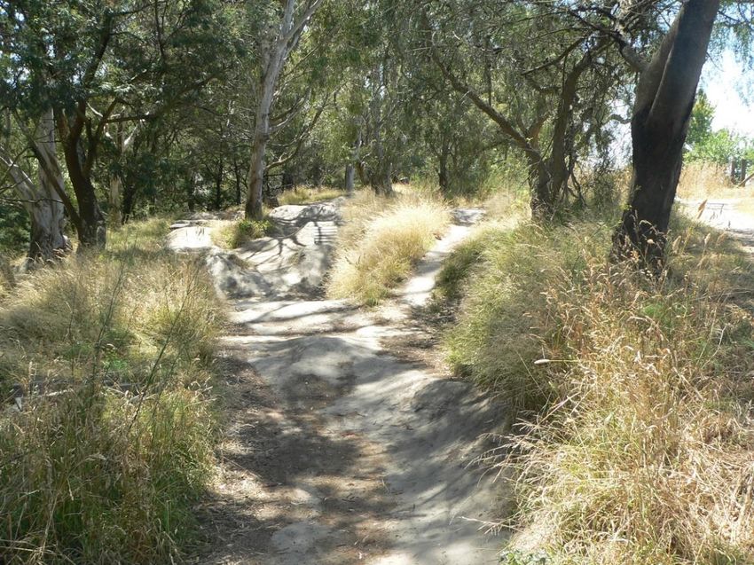
Archaeology Hawke’s Bay Ltd         HAVELOCK RESERVES ARCHAEOLOGICAL REPORT JULY 2021

INTRODUCTION

PURPOSE OF REPORT
Archaeology Hawke’s Bay Limited (AHB) has been commissioned by the Hastings District
Council (HDC) to provide an Archaeological Report to advise the upcoming Havelock North
Reserves Management Plan review. The Reserves considered herein are the Tainui, Tanner,
Tauroa and Hikanui Reserves, Havelock North; collectively identified as ‘Havelock Reserves’.
This document is intended to provide sufficient archaeological and historic background to
the area that its significance can be appropriately managed both in terms of recorded
archaeology and any potential unrecorded archaeology that may be present within the
Havelock Reserve boundaries. Whilst cultural considerations are beyond the remit of the
author, consultation with mana whenua has been integral to better understanding the
archaeological potential of this currently under-recorded area of the Havelock North hills
environs. Unfortunately, due to timing this aspect has not been as fully developed as had
been anticipated. However, collaboration and consultation with Te Taiwhenua o Heretaunga
and reporting partners has been undertaken, and a separate report has been prepared by
mana whenua for inclusion in the wider management plan review process. The briefing paper
from that report has been provided for consideration with respect to potential unrecorded
archaeological risk areas

It is appropriate to acknowledge from the outset the generosity of fellow contributors Te
Manaaki Taiao, Te Taiwhenua o Heretaunga and Richie Hill (Paper Street Tree Company) for
making available draft versions of their reports for consideration of their expert input.
Further, Dr Anthony Cole’s review of the oral narrative and background sections and
associated aspects of this report was greatly appreciated.

SCOPE OF ARCHAEOLOGICAL REPORT
This document considers the areas identified as the Tainui, Tanner, Tauroa and Hikanui
Reserves; Havelock North, Hawke’s Bay. The scope of work originally had five primary
components:

1/ identify currently or newly recorded archaeological sites in the area, accurately locate
them using GPS technology including surface plan of individual features where appropriate,
and the Site Record Numbers as allocated in ArchSite;

                                                                                               4
Archaeology Hawke’s Bay Ltd          HAVELOCK RESERVES ARCHAEOLOGICAL REPORT JULY 2021

2/ identify areas of potential archaeological risk that have no current surface expression via
desktop research and tangata whenua consultation;

3/ identify past, current and future damage or threats to the archaeological resource within
Tainui Reserve;

4/ provide guidance and recommendations for the long term management of the Tainui
Reserve as relates to the archaeological record;

5/ identify which sites may need to be classified as ‘confidential’ for District Plan purposes.

LOCATION AND LEGAL DESCRIPTION

TAINUI RESERVE

Physical address: Tainui Drive, Havelock North, 4130

Legal Description: SEC 2 SO 314654 LOT 35 DP 26487 LOTS 33 34 DP 28692 BLK IV TE MATA
SD PLANTATION RES TAINUI HERITAGE WALK

TANNER RESERVE

Physical address: Joll Road, Havelock North, 4130

Legal Description: LOT 38 DP 14421 RECREATION RESERVE

TAUROA RESERVE

Physical address: 43 Tauroa Road, Havelock North, 4130

Legal Description: LOT 79 DP11532

HIKANUI RESERVE

Physical address: 45 Hikanui Drive, Havelock North, 4130

Legal Description: LOT 27 Deposited Plan 26487

                                                                                                  5
Archaeology Hawke’s Bay Ltd         HAVELOCK RESERVES ARCHAEOLOGICAL REPORT JULY 2021

Figure 1 Indicative area of the Havelock Reserves within wider regional context (Source:

OpenStreetMap1).

1   https://www.openstreetmap.org/export#map=10/-39.7067/176.8133

                                                                                           6
Archaeology Hawke’s Bay Ltd          HAVELOCK RESERVES ARCHAEOLOGICAL REPORT JULY 2021

                                                             2

                                                   1
                                                                                  3

                                                                             4

Figure 2 ‘Havelock Reserves’ as identified in Hastings District Plan: 1 = Tainui, 2 = Tanner; 3 = Tauroa; 4 = Hikanui (Source: Hastings District Council

Intramaps2).

2   https://mapping.hdc.govt.nz/IntraMaps80/

                                                                                                                                                       7
Archaeology Hawke’s Bay Ltd            HAVELOCK RESERVES ARCHAEOLOGICAL REPORT JULY 2021

KEY CONTRIBUTORS
Hastings District Council have commissioned Archaeology Hawke’s Bay Ltd to prepare this
Conservation and Management Plan.

The key parties involved in the preparation of this document are:

    •   Te Taiwhenua o Heretaunga and mana whenua

    •   Hastings District Council – commissioning of the plan and governing body for
        location, responsible for day-to-day management

    •   Richie Hill – Consultant arborist (Paper Street Tree Company)

    •   Archaeology Hawke’s Bay Ltd – commissioned to prepare the plan

HISTORICAL BACKGROUND3

The focus of this section is the archaeological information and an overview of pertinent
publicly accessible published information. Detailed discussion of Māori tradition and
whakapapa will be left to those holding this knowledge.

The coastal areas of Hawke’s Bay are understood to have been widely occupied by Māori at
the time of Captain Cook’s arrival. One of the recorded names for the region (or parts
thereof) was Heretaunga-hauku-nui (Heretaunga of the heavy dew), and it was a place
renowned for being richly laden with resources (Salmond 1993: 139). The coastal plains,
fertile river valleys and deltas, bush clad hills and inland freshwater lakes and swamps
provided a resource base upon which to support intensive occupation.

Whilst the NZAA archaeological site record of Te Mata, Te Māta, Te Matā, Te Karanemanema
Te Mata o Rongokako, Te Mata o Rongokako4 and Havelock North is relatively scant in

comparison with other areas of Hawke’s Bay such as the coastal plains and coastal hills of
Tangoio, Poraiti and Waimarama, this is likely a reflection of recording and identification
biases rather than a genuine reflection of an absence of archaeological occupation evidence.
The current NZAA Site Record Database includes pits, pit clusters, terraces, garden sites,

3
 Taken from Carter 2019
4
  The naming convention adopted by Te Manaaki Taiao Te Taiwhenua o Heretaunga in association with Te Toi
Ōhanga (2018) is adopted here-in. For reporting purposes the term Te Matā … Te Mata te Tipuna is used
following the convention established in the aforementioned document.

                                                                                                           8
Archaeology Hawke’s Bay Ltd         HAVELOCK RESERVES ARCHAEOLOGICAL REPORT JULY 2021

house sites and pā. This is an archaeological reflection of the intensity of occupation and
range of activities that are understood from other sources such as the oral narratives to have
been occurring throughout the wider area.

There are a number of pā and papakāinga recorded both archaeologically and in oral
narratives in the nearby Te Matā... Te Mata te Tipuna environs including Takoremu / Rimirapa
/ Hikanui, Tawekanui, Iwipo and Ngaruahikapuu. The Tukituki Awa was a main means of
transport inland, whilst the ridgelines formed foot tracks through the landscape (Te Manaaki
Taiao et al 2018). The western side of Te Matā... Te Mata te Tipuna, including Havelock North
and its surrounding hills are less well understood in terms of the current publicly available
knowledge. However, there is work currently being undertaken by Te Manaaki Taiao Te
Taiwhenua o Heretaunga to improve this situation and record the surviving oral narratives as
relate to this area in a similar manner as has already been undertaken for the eastern side of
Te Matā... Te Mata te Tipuna. Whilst this remains a work in progress, a limited amount of
information was able to be shared via the Cultural Aspirations for the Karanema Reserve
Briefing Paper (Te Manaaki Taiao Te Taiwhenua o Heretaunga 2021)

POST-EUROPEAN CONTACT OCCUPATION

FIRST CONTACT

The first documented encounter between Hawke’s Bay Māori and Europeans occurred at Te
Matau-a-Māui, when several fishing waka approached the Endeavour and several attempts at
trade were undertaken. During these negotiations it is recorded that Tayeto (Tupaia’s boy)
was seized, however, he managed to escape back to the Endeavour. This incident gave rise
to the name associated with the area by many to the present day, Cape Kidnappers
(Salmond 1993).

EARLY EUROPEAN INFLUENCES

By the 1820s, due to passing English and American vessels, Māori were aware of the array of
new goods on offer, including muskets, animals and plants. By the 1830s potatoes and pigs
were firmly established within Māori communities, and metal tools adopted. Musket warfare
too had taken its toll (WAI0201: 3.6).

                                                                                                9
Archaeology Hawke’s Bay Ltd         HAVELOCK RESERVES ARCHAEOLOGICAL REPORT JULY 2021

Throughout the mid-1820s – 1840s the Heretaunga Plains was largely deserted by Māori
because of the musket massacre at Te Pakake in 1824. It was during this time that several
whaling stations established throughout the area. These included two operated by William
Morris: Ranga Ika and Kidnappers (MacKay 1939). Throughout the wider region, particularly
around Ahuriri, traders and missionaries were also establishing themselves.

TAINUI, TANNER, TAUROA & HIKANUI RESERVES

The township of Havelock North, within which the Havelock Reserves are located was
founded on the Karanema Block. A brief history of this Block has been presented in the
Cultural Aspirations for the Karanema Reserve Briefing Paper which should be referred to
along with the information presented herein. According to Wright (1996) the Karanema Block
land had been separated out of the Te Mata Block to aid in settling disputes.

According to Wright’s (1996) sources, the site of Havelock North was ‘little used by Māori’,
but that there were villages and other settlements nearby, and the Tukituki River valley was
recognized as an important route inland. The presence of Hikanui Pā along with the
extensive oral narratives indicates that the sources used by Wright may be inaccurate or
misinterpreted. Rather the observations may have reflected a level or pattern of occupation
at a specific point in time (mid 1800s) rather than an accurate reflection of a more ‘normal’
level of occupancy and land-use. It is hoped that further information relating to the Māori
occupation and land-use of this area may become available through the wider Management
Plan process and be able to be incorporated into both the archaeological and cultural values
and ongoing management.

The land currently referred to as the Havelock Reserves (Tainui, Tanner, Tauroa and Hikanui)
were part of a very large land block purchased in 1839 by William Barnard Rhodes that
encompassed much of the region including Te Matā... Te Mata te Tipuna (Wright 1996). The
‘Te Mata Block’ was sold again in 1855 as part of a formal land purchasing policy, negotiated
by Donald McLean (ibid: 13). However, in this sale both Karenema’s Reserve and Kahuranaki
were excluded. By 1858 a sale of Karenema’s Reserve had been negotiated by the Crown and
settler applications for the new block were being made. It is noted that Karenema’s Reserve
remains the subject of Treaty of Waitangi Claims and Wright’s 1996 information is likely to
be inaccurate in some respects.

                                                                                                10
Archaeology Hawke’s Bay Ltd HAVELOCK RESERVES ARCHAEOLOGICAL REPORT JULY 2021
At the time of sale, Karenema’s Reserve was highly desirable as a rural service centre, being
located on a major coastal to inland trade route, and surrounded by large runholders
including Chambers, Couper, Williams, Rhodes, Tanner and Ormond. Early maps and town
plans identify several ‘Reserves’ within its boundaries (Figure 3)
Figure 3 Undated map of Havelock North township identifying several areas of reserve
(https://collection.mtghawkesbay.com/objects/56895/map-havelock-north-hill-sites).
11Archaeology Hawke’s Bay Ltd HAVELOCK RESERVES ARCHAEOLOGICAL REPORT JULY 2021
DESCRIPTION5
GEOLOGY & TOPOGRAPHY
The Havelock North Reserves environs is one of moderate to steep slopes which drop into a
series of gullies. To the east lies Te Matā... Te Mata te Tipuna range, the Tukituki River and
the coast, while to the north lies Karamū Stream and associated tributaries. It should be
noted that the current alignment and size of the Karamū Stream does not accurately reflect
the former river corridors which were much broader, more braided and flood prone prior to
19th and 20th Century modifications. The town of Havelock North extends primarily to the
north of the Havelock Reserves, Te Matā... Te Mata te Tipuna Range lies to the southeast with
the ‘Havelock Hills’ extending to the south and east. To the north and west lie the extensive
river-braided Heretaunga Plains. The soils of the Havelock North area are defined as brown
and gley types and are described as deep and poorly - imperfectly drained with moderate to
high soil moisture profiles (S-Maps Online; Manaaki Whenua6).
VEGETATION & CLIMATE
The Havelock Reserves sit within an urban residential environment which is undergoing
accelerated expansion and development. Historically, it is likely that the vegetation was akin
to that of nearby Te Matā... Te Mata te Tipuna, likely including Kahikatea, Pukatea, Tawa
forest with pockets of Kauri / Taraire and Kohekohe-Tawa forest (Te Matā... Te Mata te
Tipuna vegetation data taken from Te Manaaki Taiao et al 2019: Figure 9). It has been
identified by Dr Anthony Cole (pers comm) that there are several active puna (springs) within
the Reserves and that water retention in the gullies was likely significantly better in the past
than at present.
Currently, the vegetation in these four Reserves is highly variable and includes both native
and exotic species of varying maturity, often dominated by mature pine, gum and
Macrocarpa. In the Tainui and Tauroa Reserves there has been considerable planting of
native species. Hikanui Reserve is largely open grass space with small clusters of exotic and
fruit bearing trees interspersed with natives. Tanner Reserve is a mixture of grass and exotic
trees, with some more recent native planting.
5 Taken in part from Carter 2019
6 https://smap.landcareresearch.co.nz/app
12Archaeology Hawke’s Bay Ltd HAVELOCK RESERVES ARCHAEOLOGICAL REPORT JULY 2021
Present day Hawke’s Bay has typically hot dry summers and mild winters with moderate
rainfall suited to the production of a range of exotic crops including grapes, stone-fruits and
pip-fruits. Historic records and surviving trees suggest that the climate has been amenable to
similar species since at least their introduction to the region. However, the extent to which
this climatic status reflects the longer term history of the region or is linked to more recent
(post Industrial Revolution) climatic changes is not explored herein.
CURRENT LAND-USE
The predominant land use surrounding the Havelock Reserves is suburban residential. The
Reserves are managed by HDC as recreational environments and feature numerous walking
and cycling tracks both formally constructed and informally created. All four reserves are
popular with walkers, runners and off-road cyclists, and are highly valued as green-spaces by
the local community.
TAINUI RESERVE
ARCHAEOLOGY
The Tainui Reserve currently has two recorded archaeological sites: Hikanui Pā (V21/171) and
terraces (V21/245) (Figure 4).
HIKANUI PĀ V21/171
Archaeological features evident within Hikanui Pā (V21/171) as defined in the New Zealand
Archaeological Association Site Record Form (NZAA SRF) include pits, terraces and remnant
evidence of a defensive ditch and bank. The pā as defined in the NZAA SRF is an arbitrary
and artificially defined space. Activities and occupation associated with the pā are likely to
have extended some distance from the pā boundaries as defined in the SRF. Hikanui Pā is
located on the end of a ridge and drops steeply into the surrounding gullies on three sides.
Its interior is approximately 90 m long, dropping steeply after ca. 60 m. It seems unlikely that
directly associated features extended far beyond the break of slope due to its steepness,
although current walking tracks around the upper edge may have modified or destroyed
former palisade terraces. The terrain to the east, beyond the remnant ditch (towards Hikanui
Drive) is gentler and potentially more amenable to activities directly associated with the pā.
13Archaeology Hawke’s Bay Ltd HAVELOCK RESERVES ARCHAEOLOGICAL REPORT JULY 2021
To date no archaeological features or materials have been reported in this surrounding area,
despite the presence of both formal and informal walking tracks and cycle paths.
TERRACE V21/245
The terraces of V21/245 were not clearly located according to the NZAA SRF at the
commencement of this work. The site has now been located, however only one of the two
reported terraces can be clearly identified. It is possible that the second is too eroded to be
recognized or has been lost due to ground slippage since its original recording. These
terraces would have had line of sight to Hikanui Pā, vegetation allowing, and across to Te
Matā... Te Mata te Tipuna and the Heretaunga Plains more broadly. Although not a direct
component of the pā, they likely formed part of a contiguous and contemporaneous
landscape of occupation and activity. The term ‘Terrace’ is generically applied to any area of
artificially flattened or stepped ground. Depending upon size, shape, location, aspect etc
these could variously be interpreted as areas of gardens, occupation or other activity.
Figure 4 Currently recorded archaeological sites in vicinity of Reserves considered in this report
(ArchSite).
14Archaeology Hawke’s Bay Ltd HAVELOCK RESERVES ARCHAEOLOGICAL REPORT JULY 2021
CONDITION OF RECORDED ARCHAEOLOGICAL FEATURES
HIKANUI PĀ (V21/171)
Hikanui Pā has been surveyed on two previous occassions, initially by Elizabeth Pishief
(1985), and more recently the pā and the Tainui Reserve more broadly were subject to an
Archaeological Assessment and Conservation Plan (draft) (Campbell, ca. 2010: Unpublished
Report for HDC). Between these two surveys the site was visited by A. Walton and the
conditions and identifiability of the features reported in the SRF. As part of Campbell’s
assessment the surviving features were digitally surveyed by Ben Thorne and Colin
Sutherland, and the location of mature trees within the pā recorded. The level of detail
provided in this work makes it unnecessary to re-survey the site. Rather the Pishief and
Thorne surveys (Figures 5 & 6) provide a very useful basemap upon which to monitor and
record change in condition. It is apparent that several of the terraces identified by Pishief in
1985 were not able to be relocated by Thorne in 2010.
Figure 5 Elizabeth Pishief's 1985 survey of Hikanui Pā (Source: SRF).
15Archaeology Hawke’s Bay Ltd HAVELOCK RESERVES ARCHAEOLOGICAL REPORT JULY 2021
Figure 6 Ben Thorne's ca. 2010 digital survey of Hikanui Pā (Source: Campbell Presentation).
Several inspections of the pā site have been undertaken in the course of this and associated
work relating to the short-term management of ‘at-risk’ trees within the pā and terrace
environs. Several of these visits have been in the company of representatives of HDC,
arboreal specialists and mana whenua. These site visits have provided multiple opportunities
to view the surviving above ground features, search for eroding evidence of subsurface
features and to assess both the current condition and the apparent impact of current
management and public activity on the physical integrity of the pā site, and to a lesser extent
the terrace site.
It is apparent that the surface visibility of many of the internal features of the pā have
deteriorated even since the survey undertaken in 2010. Although most of the features could
be relocated, without the aid of the pre-existing surveys a number of these would have been
difficult to identify. Several walking paths, both formal and informal bisect the site interior,
including crossing the ditch and bank, and skirt around the edges of the ridge spur. In the
past cyclists have also used these paths, although a ‘kissing’ gate has been installed at the
east entrance to the pā to deter cyclists from entering the main pā area. The main walking
16Archaeology Hawke’s Bay Ltd HAVELOCK RESERVES ARCHAEOLOGICAL REPORT JULY 2021
path at the time of this assessment is a broad (2m +) bare earth linear running the length of
the pā before it becomes a narrower made track winding down the ridge to the gully below.
It continues to cross the ditch and bank causing damage (Figure 7). According to the SRF this
track in the past has been gravelled, though little or no evidence of this surface now remains.
In addition to the formal tracks there appear to be a number of well-established informal
tracks directly affecting the pā that are in regular use by reserve users.
Figure 7 Interior of Hikanui Pā looking approximately northwest.
As with the wider Tainui Reserve, the pā area is heavily vegetated with a mixture of mature
exotic pine, gum and Macracarpa trees, along with semi and immature trees of these species.
These trees currently pose a significant risk to both the surface and subsurface physical
integrity of the pā. There is evidence of both historic and recent tree-fall events that have
resulted in significnt disturbance to the ground surface from dislodged root balls (Figure 8).
The extensive root systems of these trees are also likely disturbing, modifying or destroying
subsurface features such as hearths, postholes and pits. Ephemeral features that may be of
significance in understanding the internal organisation and activities of the pā such as
stakeholes and working areas will be largely destroyed by root action on the scale observed.
17Archaeology Hawke’s Bay Ltd HAVELOCK RESERVES ARCHAEOLOGICAL REPORT JULY 2021
Burnt stone was noted eroding from the walking path at the western end of the site in the
vicinity of an exposed root system. Whilst unclear if the burnt stone represents an in-situ
hearth that is being damaged by path users, or is root – disturbed remnant is unclear. The
presence of burnt stone eroding from the surfaces has been recorded since Pishief’s 1985
observations.
Figure 8 Example of damage occurring to pā and potential associated public safety risks
through uncontrolled tree fall: scale (arrowed) = 1 m.
In addition to the vegetation and path usage, it is also evident that historically and more
recently Reserve users have acted independently of HDC and undertaken activities that have
potentially affected the physical integrity of the site. These include the repositioning of three
large logs in a tringle arrangement within the pā (Figure 9) and bike jumps at the Hikanui
Drive entrance to the Reserve.
18Archaeology Hawke’s Bay Ltd HAVELOCK RESERVES ARCHAEOLOGICAL REPORT JULY 2021
Figure 9 Interior of Hikanui Pā as viewed towards Hikanui Drive entrance with introduced logs
in foreground.
TERRACE SITE V21/245
Terrace site V21/245 is in a similarly precarious condition. A large pine tree is immediately
adjacent the one remaining (identifiable) terrace (Figure 10). Should this tree fail it would
likely cause significant damage to the terrace. The second terrace could not be conclusively
identified. There are several potential remnants, but given the vegetation history of the
Reserve these could equally be natural features such as eroded tree boles. It is more likely
that the surface visible elements of the second terrace have been lost to erosion.
19Archaeology Hawke’s Bay Ltd HAVELOCK RESERVES ARCHAEOLOGICAL REPORT JULY 2021
Figure 10 Surviving terrace recorded as V21/245 (arrowed).
ACCESS, VISITOR FACILITIES AND INTERPRETATION
There are five access points into Tainui Reserve: Awarua Crescent, Keirunga Rd, Hikanui Drive
(x 2) and Tainui Drive. The primary Reserve users are pedestrian (walkers, joggers) and
cyclists, and there are a number of formal tracks throughout the Reserve accomodating
those activities. Pedestrian tracks and shared cycle / walking tracks are managed by HDC,
and used for a wide variety of purposes including:
• recreational walking, both with and without dogs;
• joggers / runners with and without dogs;
• recreational cyclists;
• and school and other larger parties.
These tracks range from broad gravelled pathways to narrow exposed earth tracks cut into
the side of ridges.
The Mountain Bike track is understood to be managed by the Hawke’s Bay Mountain Bike
Club and is a narrow steep downhill track following natural contours of ridge tops and
20Archaeology Hawke’s Bay Ltd HAVELOCK RESERVES ARCHAEOLOGICAL REPORT JULY 2021
slopes. This track is clearly identified via signage as cycle-only. In addition to the formal
managed tracks there is evidence throughout the Reserve of informal track creation. Whilst
for safety reasons the the Mountain Bike track was not walked, there is clear evidence on the
pedestrian tracks of shortcuts and it is assumed that to some extent the same applies on the
Mountain Bike track, although possibly to a lesser extent given the already steep nature of
many of the routes.
Signage at the entry to the Reserve and variously located throughout the track system
identifies the routes and their designated user status: pedestrian only, cycle only or shared.
However, the location of neither Hikanui Pā nor terrace site V21/245 is identified on the
current signage. Nor is there any information relating to the Reserve or its recorded and oral
narratives. Hikanui Pā is only identified on the ground by a small rusted sign ‘Hikanui Pā’.
There is no interpretative information, nor are there any explanations or guidelines for the
public around the legal protection afforded to archaeological sites. The terrace site is
currently completely unmarked or protected from inadvertant damage.
ARCHAEOLOGICAL SIGNIFICANCE
Tainui Reserve includes two recorded archaeological sites and although no additional
archaeological features have been identified via site visits and other research, it is likely that
there are additional unrecorded features present within the Reserve boundaries. Work
undertaken by Dr Anthony Cole, in association with Te Manaaki Taiao, Te Taiwhenua o
Heretaunga has revealed that Tainui Reserve is likely a surviving remnant of the original
forest vegetation of the region. Whilst the current and recent historic (latter 1800s to present
day) vegetation is dominated by exotic tree and weed species, there is potential for a unique
link to the vegetational past via seed bank preservation. From an archaeological perspective,
understanding the ecological setting within which Hikanui Pā was located would be of
immense value in better understanding the wider landscape and predicting possible
locations for currently unrecorded archaeology both within the Reserve and more broadly.
The location of Hikanui Pā and terrace site V21/245 within an essentially urban / residential
environment with easy pedestrian access makes it somewhat unique and potentially offers
significant opportunities for education and awareness. Hikanui Pā itself is of considerable
significance to mana whenua. Whilst this is not adressed directly herein, it is essential that
21Archaeology Hawke’s Bay Ltd HAVELOCK RESERVES ARCHAEOLOGICAL REPORT JULY 2021
the cultural values expressed through reports being prepared by mana whenua be included
in considering the significance of Hikanui Pā specifically and Tainui Reserve in general.
Whilst the recorded sites are noted in the District Plan, there are no other sites of
significance listed either within the District Plan or Rārangi Kōrero (HNZPT ‘The List’) for
Tainui Reserve,
TANNER, TAUROA & HIKANUI RESERVES
ARCHAEOLOGY
There are no currently recorded archaeological sites within the Tanner, Tauroa or Hikanui
Reserves, nor were any indications of unrecorded archaeological sites noted during the site
visits or desk-based research. However, it is possible that subsurface unrecorded
archaeology may be present. Particularly as many of these areas were already tree-covered
at the time of the best available aerial imagery (ca 1950). Several possible now destroyed
(developed residential areas) pit sites can be seen in the 1950s aerials in the general vicinity
of these Reserves. This further reinforces that the low number of recorded sites is a
preservation and recording bias rather than an accurate reflection of past occupation and
activity.
It has been identified via the draft Briefing Paper: Cultural Aspirations for the Karanema
Reserve (Te Manaaki Taiao, Te Taiwhenua o Heretaunga 2021) that there is an oral history of
a pā site associated with Tauroa Reserve and the stream. This area was walked on receipt of
this information and whilst no physical evidence was noted, the possibility of archaeology in
this area requires further consideration should invasive earthwork be proposed. Activities
such as track maintenance or vegetation clearance may encounter features or materials in
the future and therefore this possibility needs to be accommodated in ongoing management
plans for these Reserves.
At the time of writing there are no sites of significance listed either within the Hastings
District Plan or Rārangi Kōrero (HNZPT ‘The List’) for any of these Reserves.
22Archaeology Hawke’s Bay Ltd HAVELOCK RESERVES ARCHAEOLOGICAL REPORT JULY 2021
ACCESS, VISITOR FACILITIES AND INTERPRETATION
There are multiple access points into these Reserves. As with Tainui Reserve users include
pedestrian (walkers, joggers) and cyclists, and there are a number of formal tracks
throughout the Reserves accommodating those activities. Pedestrian tracks, managed by
HDC, are used for a wide variety of purposes including:
• recreational walking, both with and without dogs;
• joggers / runners with and without dogs;
• recreational cyclists;
• and school and other larger parties.
These tracks range from broad gravelled pathways to narrow exposed earth tracks cut into
the side of ridges. It is unclear if the Mountain Bike tracks, where present, are managed by
the Hawke’s Bay Mountain Bike Club or HDC in these Reserves. These tracks are clearly
identified via signage as cycle-only tracks. In addition to the formal managed tracks there is
evidence throughout the Reserves of informal track creation. There is clear evidence on some
pedestrian tracks of shortcuts and it is assumed that to some extent the same applies on the
cycle tracks, although possibly to a lesser extent given the already steep nature of many of
these routes.
Signage for these Reserves is similarly largely limited to track routes with little if any
emphasis on the cultural, archaeological or historic values or importance of the Reserves.
ARCHAEOLOGICAL SIGNIFICANCE
Although there are currently no recorded archaeological sites within these reserves, it is
possible that currently unrecorded sites could be encountered during routine maintenence
or new facility construction. These Reserves form part of a wider archaeological and cultural
landscape and as such require consideration within that broader framework.
23Archaeology Hawke’s Bay Ltd HAVELOCK RESERVES ARCHAEOLOGICAL REPORT JULY 2021
STATUTORY REQUIREMENTS
THE HERITAGE NEW ZEALAND POUHERE TAONGA ACT 2014
The purpose of the HNZPTA is to promote the identification, protection, preservation, and
conservation of the historical and cultural heritage of New Zealand (HNZPTA section 3),
which places emphasis on avoiding effects on heritage, including archaeological sites.
The HNZPTA provides blanket protection to all archaeological sites whether they are
recorded or not. Protection and management of sites is managed by the archaeological
authority process, administered by HNZPT. It is illegal to modify or destroy archaeological
sites without an authority to do so from HNZPT.
The HNZPTA contains a consent (authority) process for any work affecting archaeological
sites, where an archaeological site is defined as:
a. Any place in New Zealand including any building or structure (or part of
a building or structure) that:
i. was associated with human activity that occurred before 1900 or is the
site of the wreck of any vessel where that wreck occurred before 1900;
and
ii.provides, or may provide through investigation by archaeological
methods, evidence relating to the history of New Zealand (HNZPTA
Section 6); and
b. Includes a site for which a declaration is made under Section 43(1) of
the Act (such declarations are rare and usually pertain to important post-
1900 remains with archaeological values).
Any person who intends to carry out work that may modify or destroy an archaeological site,
or to investigate a site using invasive archaeological techniques, must first obtain an
authority from Heritage NZ. The process applies to sites on land of all tenure including
public, private and designated land. The HNZPTA contains penalties for unauthorised site
damage or destruction. For places in which Māori have a particular historical interest,
applications for an authority require records of appropriate tangata whenua consultation.
The archaeological authority process applies to all sites that fit the HNZPTA definition,
regardless of whether:
24Archaeology Hawke’s Bay Ltd HAVELOCK RESERVES ARCHAEOLOGICAL REPORT JULY 2021
• The site is recorded in the NZ Archaeological Association (NZAA) Site Recording Scheme
or registered by Heritage NZ;
• The site only becomes known as a result of ground disturbance; and/or,
• The activity is permitted under a district or regional plan, or a resource or building
consent has been granted.
Heritage NZ also maintains the List/Rārangi Korero (formerly the Register), which maintains a
record of Historic Places, Historic Areas, Wahi Tapu, Wahi Tapu Areas and Wahi Tupuna. The
List/Rārangi Korero can include archaeological sites. The purpose of The List/Rārangi Korero
is to inform members of the public about such places and to assist with their protection
under the RMA.
In considering any application for an authority, Heritage New Zealand Pouhere Taonga may
grant fully, or in part, or decline any application. The Act allows for up to 2 months for the
Trust to process an authority after the application has been formally lodged although, except
in special cases, the time allowed is 20 working days. There is a 15-working-day appeal
period if an authority application is granted or declined.
PROTECTED OBJECTS ACT 1975
The Protected Objects Act 1975 is administered by the Ministry for Culture and Heritage and
regulates:
• the export of protected New Zealand objects;
• the illegal export and import of protected New Zealand and foreign objects;
• the sale, trade and ownership of taonga turutu.
There are nine categories of protected objects; of relevance to the reserve are taonga turutu
(50+ year old objects related to Maori culture and society) and New Zealand archaeological
objects (materials removed from a New Zealand archaeological site).
Any newly found taonga tuturu are in the first instance Crown owned unless and until a
determination on ownership is made by the Maori Land Court. In the interim, the Ministry is
legally responsible for recording, custody, facilitating claims for ownership and any
conservation treatment for taonga tuturu. Any finds must be taken to the closest museum,
which will notify the Ministry.
25Archaeology Hawke’s Bay Ltd HAVELOCK RESERVES ARCHAEOLOGICAL REPORT JULY 2021
THE RESOURCE MANAGEMENT ACT 1991
The Resource Management Act 1991 (RMA) provides guidelines and regulations for the
sustainable management and protection of the natural and cultural environment. Section 6(f)
of the RMA recognises ‘historic heritage’ as a matter of national significance, and identifies
the need for protection of historic heritage from inappropriate subdivision, development and
use.
The definition of ‘historic heritage’ (RMA s2) refers to those natural and physical resources
that contribute to an understanding and appreciation of New Zealand’s history and cultures,
and includes historic sites, structures, places and areas, archaeological sites, and sites of
significance to Māori.
HASTINGS DISTRICT COUNCIL DISTRICT PLAN
The operative and proposed Hastings District Council District Plan (HDCDP7) recognizes that
heritage can be expressed through inherited assets that include, amongst others:
archaeological sites and sites of significance to Tangata Whenua. It further recognizes that
earthworks activities can compromise historic heritage and cultural heritage features
including archaeological sites (Objective EM05; Policy EMP148), and that any such activity is
subject to HNZPTA 2014.
OTHER LEGISLATION
It must be noted that in the event that koiwi tangata (human remains) are identified that the
relevant processes are enacted, including compliance with the Burials and Cremations Act
1964.
Further, whilst outside the remit of the author to discuss, expectations and requirements
under both Te Tiriti o Waitangi (The Treaty of Waitangi) and any relevant Treaty Settlements
must also be included in the on-going management of the Havelock Reserves.
7 https://eplan.hdc.govt.nz/eplan/
8 https://eplan.hdc.govt.nz/eplan/
26Archaeology Hawke’s Bay Ltd HAVELOCK RESERVES ARCHAEOLOGICAL REPORT JULY 2021
THREATS TO HERITAGE
THREAT IDENTIFICATON & MITIGATION
Key aspects of the proposed Havelock Reserves Management Plan are to: 1/ identify current
risks to the heritage places included within the Reserves; and 2/ implement appropriate
actions to remove or mitigate actual or potential damage.
As there are currently no recorded archaeological sites in Tanner, Tauroa or Hikanui
Reserves, the impact of these threats is largely limited to Tainui Reserve. However, should
archaeology be encountered in the future in these other Reserves the same considerations
would apply. Noting that in the case of Tauroa Reserve recently shared oral history
information suggests a pā site in association with the stream.
The primary threats identified within the Reserves are:
• Natural processes including vegetation and weather
• Visitor activities
• Loss of integrity
• Loss of information
These threats are specifically addressed below.
NATURAL PROCESSES INCLUDING VEGETATION AND WEATHER
Threats
Aside from Hikanui Reserve, which is currently a largely grassed environment with a limited
number of smaller trees, all three other Reserves are dominated by mature exotic tree
species including pine, gum and Macrocarpa. In many cases these trees have been subject to
limited maintenance or control and therefore a number are increasingly at risk of partial or
complete failure (Figure 11). This poses risks relating to damage caused to archaeological
sites or features through the fall impact, and damage caused by the uprooted root ball.
Where these trees are directly growing on or near archaeological features they are also
potentially damaging or destroying sub-surface features via root action.
The state of the vegetation and track network is in large part the result of the natural reserve
status of Tainui Reserve in particular. The tree stock has been largely left to nature, with the
27Archaeology Hawke’s Bay Ltd HAVELOCK RESERVES ARCHAEOLOGICAL REPORT JULY 2021
result that not only are the species inappropriate for archaeological site management, but
they have been left to grow and fail largely unchecked except where public safety becomes a
concern.
Tainui Reserve features numerous steep sided gullies, including those directly associated
with Hikanui Pā and terrace site V21/245. There is abundant evidence in the form of recent
and historic slips that these slopes are unstable, and weak areas are likely to subside during
heavy rain events. Similarly, ‘at risk’ trees are at increased risk of failure during heavy rain or
wind events. Hill (2021) notes in his arboriculture report that the western slope of the pā
seems particularly prone to wind related tree throw damage and shows signs of ground
movement.
Whilst the current tree cover is in many respects inappropriate and posing a threat, it is also
serving to break the intensity of rainfall striking the ground and thus reducing the erosive
forces of heavy rain events. Further, the existing tree cover has established with the
prevailing wind conditions. Removal of some trees will inevitably affect the wind dynamic
affecting those left standing, potentially leading to failure in trees that were otherwise stable
(Richie Hill, pers comm & Hill, 2021).
Once toppled or felled current practice in Tainui Reserve often seems to be the removal of
the stem, potentially involving dragging downslope to a suitable processing area. This action
further increases the risk of damage to archaeological features in sensitive areas.
28Archaeology Hawke’s Bay Ltd HAVELOCK RESERVES ARCHAEOLOGICAL REPORT JULY 2021
Figure 11 Example of a 'failed' tree in Tauroa Reserve.
Mitigation or Actions
Curbing of the damage currently being caused by the inappropriate vegetation and
condition of the trees is imperative for the long-term preservation of Hikanui Pā. This has
been recognized by HDC and specialist advice has been sought regarding the condition of
the trees and how they might best be dealt with. Whilst outright removal of the trees may
seem the most appropriate action to curb root damage, as discussed above this action may
have more damaging consequences.
The report prepared by Richie Hill (2021) discusses these issues in some depth. Whilst the
trees do need to be managed and ultimately removed or prevented from causing further
damage, achieving this will require a long term and staged approach to removal and
replacement with suitable ground stabilizing cover species. This approach will require input
from specialist fields including but not limited to archaeology, arboriculture, ecology and
mana whenua. Commissioning and actioning this long-term management approach should
be a key outcome of the proposed Havelock Reserves Management Plan.
29Archaeology Hawke’s Bay Ltd HAVELOCK RESERVES ARCHAEOLOGICAL REPORT JULY 2021
Mitigating additional damage caused by removal of stems also needs to be considered.
Ideally, stems could remain in-situ, left to rot naturally rather than be mechanically removed
by dragging. If this is not possible or is unsafe, measures such as reducing the stems into
shorter more manageable sections may prove less damaging, or processing into firewood
rings in-situ which may be more labour intensive but less destructive. Using a corduroy /
mattress technique to protect the ground surface is recommended, and where suitable
natural material is not available, machine tracking mats have proven effective at reducing
both fall impact and drag impact. It is anticipated that this approach will only be required
within the immediate vicinity of the archaeological sites not necessarily Reserve-wide. The
‘Caring for Archaeological Sites’ report (Jones 2007) remains the current ‘go to’ document
guiding tree removal and suitable replanting species for situations like this and should be
utilized by all contributing specialists during the Management Planning process, and by HDC
more broadly.
VISITOR ACTIVITIES
Threats
The primary activities in these Reserves centres around walking / jogging / recreational
cycling and mountain biking. For the most part these activities are kept separate by means of
dedicated tracks.
Pedestrians
Pedestrian impacts can be categorized as relating to foot traffic on the official track network
and the impacts of unofficial tracks. At present there are several pedestrian tracks within, and
in the immediate vicinity of, Hikanui Pā This includes a wide swathe of exposed ground
running through the interior of the pā and across the bank and ditch. Several narrow tracks
run around the immediate edges of the pā partially cut into the ridge slope. It is unclear if
these tracks follow some form of pre-existing terracing or if they have been entirely cut into
previously unmodified slope. Archaeological materials (burnt stone) can be observed eroding
out of the bare ground in several places.
Elsewhere throughout the Reserves it is evident that unofficial tracks and shortcuts are being
utilised (Figure 12). These activities are resulting in uncontrolled and unmitigated erosion in
numerous locations throughout the reserve. Should currently unrecorded archaeology be
30Archaeology Hawke’s Bay Ltd HAVELOCK RESERVES ARCHAEOLOGICAL REPORT JULY 2021
exposed in these areas it is likely to be substantially damaged before it is noticed and
reported.
Cyclists
There are multiple dedicated and shared cycle tracks throughout the Reserves, usually one of
each type per Reserve. Whilst none currently run in the immediate environs of Hikanui Pā,
the dedicated downhill track’s start point is within 100 m of the site, utilising the same
shared access as pedestrians. Although designated as walking track access, it is understood
that in the past the pits and other features within the pā have been used as jumps (cf
Campbell 2010). This behaviour seems to have been significantly reduced by the installation
of the kissing gates and provision of a dedicated down-hill cycle track.
Downhill cycling, by its nature, can be highly erosive to the ground surfaces in localised areas
– tight turns, braking points. If unrecorded archaeology is present albeit subsurface even
post track construction, it will inevitably become exposed and damaged. As these tracks are
not available for pedestrian access any such exposure would need to be identified and
reported by a member of the user group.
Unauthorised activities
In addition to these track related threats from visitor use, two notable examples of non-
authorised behaviour are currently affecting or potentially affecting Hikanui Pā. Firstly, the
construction of cycle jumps at the Hikanui Drive entrance to the Reserve (Figure 13), and
secondly the introduction of seating onto the site via the re-positioning of three large logs.
The cycle jumps are understood to be created by local children and have been
decommissioned by HDC on several occasions and later reconstructed by or for the children.
This activity is occurring within the wider area of Hikanui Pā and any invasive digging in this
locale should have been assessed for risk by a suitably qualified archaeologist regarding the
requirement for an Archaeological Authority.
The logs are sitting on the ground surface within the pā, repositioned into a triangle
formation. It is likely that this involved dragging and rolling of the logs along the ground
surface which had the potential to disturb underlying features. The primary ongoing risk
posed is to the ground surface around these logs where people will be drawn to use them
potentially causing localised surface erosion issues.
31Archaeology Hawke’s Bay Ltd HAVELOCK RESERVES ARCHAEOLOGICAL REPORT JULY 2021
Figure 12 Example of informal track formation in Tauroa Reserve.
Figure 13 Unauthorized jumps created at the Hikanui Drive entrance to Tainui Reserve.
32Archaeology Hawke’s Bay Ltd HAVELOCK RESERVES ARCHAEOLOGICAL REPORT JULY 2021
Mitigation or Actions
The primary threat to the recorded archaeology is inappropriate or uncontrolled access
through sensitive locations causing erosion damage. By extension currently unrecorded sites
or features would be similarly affected were they to be exposed. At present the primary
concern is the immediate area of Hikanui Pā. The main pedestrian access through the pā is a
wide swathe of bare ground through which burnt stone, indicative of underlying hearth type
features is eroding. This track also directly crosses the ditch and bank feature. There are also
a small number of activities that are not HDC approved but are impacting the archaeological
sites.
Hikanui Pā Pedestrian Access Management
There is currently no attempt to manage pedestrian access within the pā environment to
protect the visible features such as the ditch and bank, pits and terraces. Part of the purpose
of the proposed management plan is to better manage and protect Hikanui Pā, and by
extension terrace V21/245 and any future identified archaeological sites within the reserve
boundaries. This will need to include measures that better control access through and
around the archaeological sites and measures that protect the sites from erosion damage
caused by visitor usage. Options to consider could include raised walkways either structural
or ‘made’ ground, including potentially ‘sky walks’ utilizing existing trees that might be
determined better left in-situ than removed. Strategic and carefully designed and selected
planting could provide a means to guide traffic through the pā in a culturally and
archaeologically ‘safe’ manner.
De-commissioning of the narrow tracks around the edge of the pā site is necessary as these
tracks are potentially destroying or modifying archaeological features associated with the pā.
Further their ‘narrowness’ and the steep nature of the drop to the gully in some places
encourages users to make use of vegetation on the banks for stability. Finally, they are
potentially contributing to creating an unstable slope, which should it collapse will
potentially take with it and destroy any archaeological features or materials that might be
present. The stability, long-term impacts and appropriateness of all the tracks, formal and
informal, around the pā should be assessed as part of the long-term pā management plan.
Remediation of the track cuts should be discussed with suitably qualified experts. It may be
that exclusion and stabilisation is better achieved via biocoir and appropriate plantings.
33You can also read