BASELINE TRANSPORT REVIEW - London Borough of Enfield - Enfield Council
←
→
Page content transcription
If your browser does not render page correctly, please read the page content below

London Borough of Enfield

BASELINE TRANSPORT REVIEW

JUNE 2021                   PUBLIC

London Borough of Enfield

BASELINE TRANSPORT REVIEW

TYPE OF DOCUMENT (VERSION) PUBLIC

PROJECT NO. 70081462

DATE: JUNE 2021

WSP
WSP House
70 Chancery Lane
London
WC2A 1AF
Phone: +44 20 7314 5000
Fax: +44 20 7314 5111
WSP.com

                                    PUBLIC
QUALITY CONTROL

Issue/revision     First issue      Revision 1       Revision 2   Revision 3

Remarks            DRAFT            Final
Date               20/04/2021       17/06/2021
Prepared by        Louise Murray-   Louise Murray-
                   Bruce            Bruce
Signature

Checked by         Rea Turohan      Rea Turohan
Signature

Authorised by      Alex Andrews     Alex Andrews

Signature

Project number     70081462         70081462

Report number
File reference

Baseline TRANSPORT REVIEW                                           PUBLIC | WSP
Project No.: 70081462                                                  June 2021
London Borough of Enfield
CONTENTS

      EXECUTIVE SUMMARY

1     INTRODUCTION                                    1

1.1   OVERVIEW                                        1
1.2   STAGE 2                                         1
1.3   STUDY AREA                                      2

2     METHODOLOGY                                     4

2.1   INTRODUCTION                                    4
2.2   PLANNING POLICY DOCUMENTS                       4
2.3   REVIEW OF EXISTING DOCUMENTS                   12

3     EXISTING CONDITIONS                            19

3.1   INTRODUCTION                                   19
3.2   ACTIVE TRAVEL ANALYSIS                         19
3.3   HIGHWAY MODEL BASE YEAR ANALYSIS               21
3.4   PUBLIC TRANSPORT BASE YEAR ANALYSIS            32

4     CONCLUSIONS                                    52

4.1   CONCLUSION                                     52

      Baseline TRANSPORT REVIEW             PUBLIC | WSP
      Project No.: 70081462                    June 2021
      London Borough of Enfield
TABLES
Table 2-1 - Summary of relevant documents reviewed                   16
Table 4-1 - Summary of Active Travel findings                        52
Table 4-2 - Summary of existing Highway Network                      53
Table 4-3 - Summary of existing bus network                          54
Table 4-4 - Summary of existing rail network                         54

FIGURES
Figure 1-1 - Proposed Study Area - Highway Model                      2
Figure 1-2 - Proposed Study Area - Public Transport Model             3
Figure 2-1 – The 10 Healthy Streets Indicators                       13
Figure 3-1 - Existing Cycle Network                                  19
Figure 3-2 - Walking neighbourhoods                                  20
Figure 3-3 - Actual Flows - AM Peak                                  21
Figure 3-4 - Actual Flow - PM Peak                                   22
Figure 3-5 - Actual vs Demand Flows - AM Peak                        23
Figure 3-6 - Actual vs Demand Flows - PM Peak                        23
Figure 3-7 - Delay - AM Peak                                         24
Figure 3-8 - Delay PM Peak                                           25
Figure 3-9 - Free Flow speed - AM Peak                               26
Figure 3-10 - Free Flow speed- PM Peak                               26
Figure 3-11 - Volume/Capacity - AM Peak                              27
Figure 3-12 - Volume/Capacity - PM Peak                              28
Figure 3-13 - Origin and Destination Trip Ends AM Peak               29
Figure 3-14 - Origin and Destination Trip Ends PM Peak               29
Figure 3-15 - Number of Trips within Enfield AM Peak                 30
Figure 3-16 - Number of trips within Enfield PM peak                 31

Baseline TRANSPORT REVIEW                                   PUBLIC | WSP
Project No.: 70081462                                          June 2021
London Borough of Enfield

Figure 3-17 – Total number of bus passengers alighting AM Peak             32
Figure 3-18 – Total number of bus passengers alighting PM peak             33
Figure 3-19 – Total number of rail passengers alighting AM Peak            34
Figure 3-20 – Total number of rail passengers alighting PM peak            35
Figure 3-21 – Total number of bus passengers boarding AM peak              36
Figure 3-22 – Total number of bus passengers boarding PM peak              37
Figure 3-23 – Total number of rail passengers boarding AM peak             38
Figure 3-24 – Total number of rail passengers boarding PM peak             39
Figure 3-25 - Bus passenger flows AM peak                                  40
Figure 3-26 - Bus passenger flows PM peak                                  41
Figure 3-27 - Rail passenger flows AM peak                                 42
Figure 3-28 - Rail passenger flows PM peak                                 43
Figure 3-29 - Crowding on Rail services AM peak                            44
Figure 3-30 - Crowding on Rail Services PM peak                            45
Figure 3-31 - Transfer passengers alighting AM peak                        46
Figure 3-32 - Transfer passengers alighting PM peak                        47
Figure 3-33 – Transfer passengers boarding AM peak                         48
Figure 3-34 - Transfer passengers boarding PM peak                         49
Figure 3-35 – All public transport Trips AM peak                           50
Figure 3-36 – All public transport trips PM peak                           51

APPENDICES

BASE MODEL OUTPUTS

EVIDENCE BASE RESULTS

Baseline TRANSPORT REVIEW                                         PUBLIC | WSP
Project No.: 70081462                                                June 2021
London Borough of Enfield

EXECUTIVE SUMMARY

WSP has been appointed by the London Borough of Enfield to prepare its transport evidence base
and supporting transport assessment for the new Local Plan. This work will be undertaken over a
number of months until completion of the Local Plan process. This initial baseline report has been
compiled using evidence provided by Enfield Council, TFL modelling suite and other documents and
information provided by statutory stakeholders.

Baseline TRANSPORT REVIEW                                                           PUBLIC | WSP
Project No.: 70081462                                                                  June 2021
London Borough of Enfield

1        INTRODUCTION

1.1      OVERVIEW
1.1.1.   WSP has been appointed by London Borough of Enfield (LBE) to support the preparation of a new
         Local Plan for the Borough.
1.1.2.   This report seeks to assess the existing transport network in Enfield which forms the baseline
         conditions for Enfield before the proposed or planned growth in the Borough.
1.1.3.   WSP will be using the 2016 base year Transport for London’s (TfL’s) models to produce a set of
         outputs which will demonstrate the current conditions in Enfield. These outputs will cover the
         Highway, Rail, Underground and Bus networks as well as the existing cycling and walking network.
1.1.4.   In conjunction with the baseline outputs, we have reviewed a list of documents which contain
         previous studies undertaken for the Borough. The studies will typically have been produced for
         specific briefs and are reflective of the assumptions at the time (be it growth, infrastructure or
         modelling approach). These documents include the following:
         ¡   Mayor’s Transport Strategy (MTS) supporting evidence
         ¡   London Plan Evidence Base
         ¡   Updated Upper Lee Valley Opportunity Area Planning Framework transport study
         ¡   Enfield Rapid Transit Study
         ¡   Meridian Water planning applications
         ¡   Northern Gateway Access Package (NGAP)
         ¡   Crews Hill Whitewebbs (CHWW)
         ¡   North London Sub Regional Plan
         ¡   Anglia Route Study
         ¡   LBE Infrastructure Delivery Plan
         ¡   LBE Transport Plan (Local Implementation Plan)
1.1.5.   In particular this study report has regard to the relevant MTS outcomes and policies as agreed by
         TfL and the GLA, and is prepared in accordance with other relevant national, regional and local
         policy guidance.
1.1.6.   The results of this desktop review will demonstrate an understanding of the current baseline
         conditions on the public transport and highway networks highlighting the constraints, challenges and
         opportunities.
1.1.7.   The initial findings have been shared with the key stakeholders as part of the Regulation 18
         consultation process.

1.2      STAGE 2
1.2.1.   The overall transport study is outlined in the following stages:
         ¡   Stage 1: Inception
         ¡   Stage 2: Current Baseline
         ¡   Stage 3: Model Validation
         ¡   Stage 4: Future Baseline
         ¡   Stage 5: Land Use Scenarios

         Baseline TRANSPORT REVIEW                                                                PUBLIC | WSP
         Project No.: 70081462                                                                        June 2021
         London Borough of Enfield                                                                  Page 1 of 54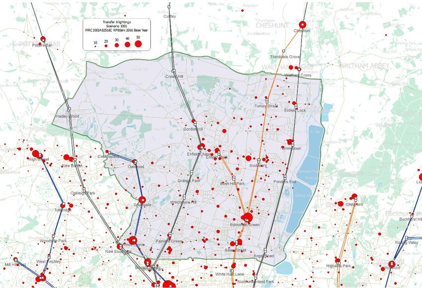
¡ Stage 6: Transport Mitigations
1.2.2.   This report forms part of stage 2 (Current Baseline).

1.3      STUDY AREA
1.3.1.   Figure 1-1 shows the extent of the Enfield borough including a 2 km buffer around for the proposed
         study area for the highway assessment of links. Figure 1-2 shows the extent of the public transport
         assessment which includes all stations and lines (both bus and rail) that are situated within LBE as
         marked by the red boundary line. These two Figures form the extent of the study area for the
         assessments undertaken.
1.3.2.   The study area encompasses the national strategic road and rail links including the M25, A1055,
         A10 and A406 as well as the proposed Crossrail 2 service.

         Figure 1-1 - Proposed Study Area - Highway Model

         Baseline TRANSPORT REVIEW                                                              PUBLIC | WSP
         Project No.: 70081462                                                                      June 2021
         London Borough of Enfield                                                                Page 2 of 54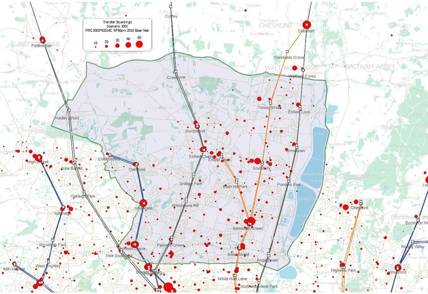
Figure 1-2 - Proposed Study Area - Public Transport Model

Baseline TRANSPORT REVIEW                                   PUBLIC | WSP
Project No.: 70081462                                           June 2021
London Borough of Enfield                                     Page 3 of 54
2        METHODOLOGY

2.1      INTRODUCTION
2.1.1.   This section details the planning policy objectives, highlighting relevant objectives that would impact
         the assessment of the baseline conditions and potential opportunities for improvements.

2.2      PLANNING POLICY DOCUMENTS
2.2.1.   The relevant planning policy documents that are reviewed include the following:
         ¡   The National Planning Policy Framework (NPPF) 2019
         ¡   The Mayor’s London Plan 2021
         ¡   The Broxbourne Local Plan June 2020
         ¡   Hertfordshire’s Local Plan 2018-2031
         ¡   Haringay’s Local Plan: Strategic Policies 2013- 2026
         ¡   Barnet’s Draft Local Plan (Regulation 18) January 2020
         ¡   Waltham Forest Local Plan (LP1) 2020-2035
         ¡   Essex County Council Local Transport Plan
         ¡   Lee Valley Regional Park Authority, Park Development Framework Strategic Policies
         ¡   Enfield Core Strategy
         ¡   North East Enfield APP
         ¡   North Circular AAP
         ¡   Edmonton Leeside AAP
         ¡   Development Management Documents (DMD)
         THE NATIONAL PLANNING POLICY FRAMEWORK
2.2.2.   The National Planning Policy Framework (NPPF), published by the Ministry of Housing, Communities
         and Local Government (MHCLG) in February 2019, sets out the Government’s planning policies for
         England and how they should be applied. At the heart of the NPPF is the presumption in favour of
         sustainable development which needs to be applied in plan-making and decision-taking. The NPFF
         recognises that there are three separate, but inter-linked, pillars to sustainability – economic, social
         and environmental.
2.2.3.   The NPPF recognises the role of planning in contributing to building a strong, responsive and
         competitive economy by identifying and coordinating development, including the provision of
         infrastructure.
2.2.4.   The policies within the NPPF aim to deliver new homes, support economic growth whilst emphasising
         the role that town centres play at the heart of local communities. This community-centric approach
         includes polices to create healthy, inclusive and safe places that encourage active and sustainable
         travel. The NPPF makes it clear that significant development needs to be focussed in locations that
         offer a genuine choice of transport modes to help reduce congestion, emissions and improve air
         quality, public health and support the transition to a low carbon future.

         Baseline TRANSPORT REVIEW                                                                PUBLIC | WSP
         Project No.: 70081462                                                                        June 2021
         London Borough of Enfield                                                                  Page 4 of 54
2.2.5. The NPPF highlights the great importance of protecting Green Belt land through it’s Green Belt policy.
It suggests that any proposals for new Green Belt should be able to demonstrate the necessity for the
Green Belt and its consistency with strategic policies for adjoining areas. This document provides
room for exceptional circumstances to justify changes to Green Belt boundaries and suggests that
“Where it has been concluded that it is necessary to release Green Belt land for development, plans
should give first consideration to land which has been previously developed and/or is well-served by
public transport. They should also set out ways in which the impact of removing land from the Green
Belt can be offset through compensatory improvements to the environmental quality and accessibility
of remaining Green Belt land”.
THE MAYOR’S LONDON PLAN 2021
2.2.6. The Mayor’s London Plan 2021 has been developed to set out objectives for the Greater London
Authority which are:
¡ Promote economic development and wealth creation in Greater London
¡ Promote social development in Greater London and
¡ Promote the improvement of the environment in Greater London
2.2.7. The London Plan aims to accommodate the majority of London’s growth within its boundaries as set
out in Policy D3 through investment in strategic infrastructure to support housing and business
development in particular in growth locations to meet need and secure mutual benefits for London.
2.2.8. As part of Policy H1 “Increasing housing supply”, The London plan refers to the London-wide
Strategic Housing Market Assessment (SHMA) that has identified the need for 66,000 additional
homes per year and covers the overall housing need for specific requirements. The document sets
out the ten-year targets for new housing completions and recognises the need for the Boroughs to
prepare delivery-focused Development plans which enable the delivery of housing capacity
identified in Opportunity Areas, while working closely with the GLA.
2.2.9. This document outlines its’ strategic approach to transport in Policy T1, which includes:
¡ Development Plans should support, and Development Proposals should facilitate the delivery of
the Mayor’s strategic target of 80% of all trips in London to be made by foot, cycle or public
transport by 2041.
¡ All developments should make the most effective use of land, reflecting its connectivity and
accessibility by existing and future public transport, walking and cycling routes, and ensure that
any impact on London’s transport networks and supporting infrastructure are mitigated
2.2.10. Under Policy T2 Healthy Streets, this document outlines that development proposals should:
¡ Demonstrate how they will deliver improvement that support the ten Healthy Streets Indicators
(as set out in the Mayor’s Transport Strategy)
¡ Reduce the dominance of vehicles on London’s streets
¡ Be permeable by foot and cycle and connect to local walking and cycling networks as well as
public transports
2.2.11. Furthermore, this Policy T2 recognises that to support growth in Opportunity Areas, there is a need
to provide new and improved walking, cycling and public transport networks to encourage a mode
shift towards active travel and public transport.
Baseline TRANSPORT REVIEW PUBLIC | WSP
Project No.: 70081462 June 2021
London Borough of Enfield Page 5 of 542.2.12. The document recognises that if London is to meet the challenges of the future, especially outer
London where the suburban pattern of development has significant potential for additional housing,
change will need to embraced and managed. These key areas identified for significant change are
known as Opportunity Areas and this document provides support for the collaborative preparation
and implementation of planning frameworks.
2.2.13. As part of Policy T3 Transport capacity, connectivity and safeguarding the London plan indicates
that development plans and decisions should support the current and expanded public and active
travel system by safeguarding London’s walking and cycling networks, safeguarding the relevant
sites for public transport/active travel and identifying new route alignments to provide improved local
connectivity by public transport, walking, cycling as well as sustainable deliveries and servicing.
2.2.14. The London Plan identifies under Policy G2 that London’s Green Belt should be protected from
inappropriate development, however exceptional circumstances will be reviewed under the
preparation of a local plan. The document outlines that the Mayor will work with boroughs and
strategic partners to enhance access to the Green Belt and improve quality of such areas that is
appropriate within the Green Belt.
HARINGAY’S LOCAL PLAN: STRATEGIC POLICIES 2013- 2026
2.2.15. Haringay’s Local Plan strategic policies document, referred to as the Local Plan sets out a vision for
how the Council will address local and strategic development needs. The strategic policies adopted
by this Local Plan are underpinned by the number of changes in the overarching planning
framework at both National and Regional level.
2.2.16. This Local Plan recognises there will be significant growth in population for London particularly
within the London-Stansted-Cambridge-Peterborough region (North London), which Haringay is
strategically located, and subsequently adequate policies have been set out to meet this future
demand in the borough.
2.2.17. As part of this Local Plan, the Council recognises people at the heart of change, creating an
environmentally sustainable future and ensuring economic vitality for Haringay’s economy.
2.2.18. As set out in the Strategic Policy 7, the Council agrees to work with its partners to promote key
infrastructure proposals to support Haringey’s regeneration and local/strategic access to London,
employment areas and local service. This policy commits to promoting sustainable transport and
tackling climate change whilst providing improved connectivity to key employment areas and
services with neighbouring boroughs.
2.2.19. This Local Plan also recognises the importance of the Upper Lee Valley Opportunity Areas and
references the need of delivering transport infrastructure to support the growth in this area as
outlined in a separate Upper Lee Valley Opportunity Area Transport study.
BARNET’S DRAFT LOCAL PLAN (REGULATION 18) JANUARY 2020
2.2.20. The Council is in the process of updating the Borough’s planning policies and a Draft Local Plan
document was prepared to set out the Council’s preferred policy approach for the next 15 years.
Public Consultation on the Draft Local Plan took place in between January and March 2020 and an
updated version will be published following the consultation.
Baseline TRANSPORT REVIEW PUBLIC | WSP
Project No.: 70081462 June 2021
London Borough of Enfield Page 6 of 542.2.21. This document provides a strategy for delivering the Council’s priorities through sustainable
development. It identifies areas for housing and employment growth and reflect the benefits of
Crossrail 2 infrastructure investment
2.2.22. This document has set out a series of core objectives to deliver the Local Plan and some of which
are highlighted below:
¡ To manage housing growth to meet housing aspirations
¡ To meet social infrastructure needs
¡ To promote Barnet as a place of economic growth and prosperity
¡ To improve orbital connectivity and sustainable travel including walking and cycling
¡ To improve access to, and enhance the contribution of the green belt and natural open spaces
2.2.23. This Local Plan recognises the importance of improving transport infrastructure, particularly the
need to reduction in car use as part of an overall transport strategy as part of its Policy TRC01. To
improve connectivity, this document priorities to provide the following:
¡ Investing in infrastructure
¡ Ensuring efficient use of the local road network
¡ Delivery of High quality transport systems in growth areas
THE BROXBOURNE LOCAL PLAN JUNE 2020
2.2.24. Broxbourne’s Local Plan covers the period 2018-2033 and sets outs a vision for the Council to make
Broxbourne a more desirable and prosperous place to live, work and visit.
2.2.25. The Local Plan consists of a number of key objectives which include:
¡ Economy: Strengthen the local economy through employment
¡ Housing: Provide a range of housing affordability and to meet all needs
¡ Town Centres, Shopping and Leisure
¡ Sustainable Neighbourhoods: Ensure that growth and regeneration to improve the physical
quality and social and economic prosperity of neighbourhoods for residents, businesses, workers
and visitors
¡ Transport: Ensure growth and regeneration can be safely accommodated by local roads, the A10
and the West Anglia Mainline and ensure that it encourages PT journeys and active travel
alternative to driving.
2.2.26. This Local Plan recognises the need to improve its transport networks to ensure that regeneration
growth can be appropriately accommodated in the borough. This document also recognises the
need to improve sustainable transport modes and ensure they are safe, secure, direct, frequent and
affordable to enable people choose more sustainable modes.
WALTHAM FOREST LOCAL PLAN (LP1) 2020-2035 – PROPOSED SUBMISSION
DOCUMENT
2.2.27. This Local Plan sets out the Waltham Forest’s planning policy Framework that seeks to meet the
rising level of growth including the number of homes and employment provision. It is set to replace
the Core Strategy (2012) and has undergone the final stage of public consultation between 26
October and 14 December 2020. Policies in this Local Plan have been informed by the outcome of
the previous public consultations.
Baseline TRANSPORT REVIEW PUBLIC | WSP
Project No.: 70081462 June 2021
London Borough of Enfield Page 7 of 542.2.28. This document sets outs the strategic priorities for development and sustainable growth of the
borough over the next 15 years, these include:
¡ Ensuring growth is sustainable and supported by infrastructure
¡ Promoting the economy
¡ Increasing housing and affordable housing
¡ Protecting and enhancing the natural environment
2.2.29. This Local Plan recognises the importance of connectivity to the increased growth in Waltham
Forest and has set out a vision to improve its public transport network and has an overall aim to
achieve an 80% mode share for active and sustainable travel by 2041. As part of its Policy 62- to
promote sustainable travel, it seeks to ensure neighbourhoods have good connections to public
transport including increasing capacity and comfort of existing public transport infrastructure and to
improve local connections to increase active travel.
HERTFORDSHIRE’S LOCAL TRANSPORT PLAN 2018-2031
2.2.30. Hertfordshire’s LTP4 sets out how HCC will enhance transport provision within the county to meet
future needs. Previous versions of the LTP have been traditionally focused on car-based schemes,
but the approach is changing to reflect societal needs and a change in overarching national policy.
2.2.31. The overall approach of Hertfordshire’s LTP4 is more balanced, focusing on all forms of transport and
aims to encourage a modal shift away from private car to more sustainable alternatives. It recognises
that comprehensive packages are required which manage demand and encourage people to change
their travel behaviour.
2.2.32. HCC recognises that there will be increased demand for travel in the coming years due to population
and employment growth.
2.2.33. Hertfordshire’s LTP4 also recognises that addressing the challenge of increased future travel demand
will require significantly stronger support for walking, cycling, passenger transport and traffic demand
management measures. The strategy set out in the Hertfordshire’s LTP4 is based on a set of nine
objectives, focused on the themes of prosperity, people and place:
¡ improve access to international gateways and regional centres outside Hertfordshire;
¡ enhance connectivity between urban centres in Hertfordshire;
¡ improve accessibility between employers and their labour markets;
¡ enhance journey reliability and network resilience across Hertfordshire;
¡ enhance the quality and vitality of town centres;
¡ preserve the character and quality of the Hertfordshire environment;
¡ reduce carbon emissions;
¡ make journeys and their impact safer and healthier; and
¡ improve access and enable participation in everyday life through transport.
2.2.34. These objectives and themes can help to realise some transformative opportunities for Hertfordshire,
such as supporting economic growth and regeneration through enhanced connectivity and tackling
health issues such as obesity and air pollution.
ESSEX COUNTY COUNCIL LOCAL TRANSPORT PLAN
2.2.35. Essex County Council published in 2011 their Local Transport Plan, the document is set into two
parts, the Transport Strategy and the Implementation Plan. The document recognises West Essex
Baseline TRANSPORT REVIEW PUBLIC | WSP
Project No.: 70081462 June 2021
London Borough of Enfield Page 8 of 54as a busy area including areas of employment in research and development, Standstead airport and
locat towns such as Epping which are affected by congestion during peak times of travel. The good
access to the London Underground Central Line is also recignised from Loughton and Epping
athough growing congestion and acces to the stations is an area of concern.
2.2.36. To benchmark the Transport Strategy success five outcomes have been set alongside the
challenges to deliver these:
¡ Provide connectivity for Essex communities and international gateways to support sustainable
economic growth and regeneration.
¡ Reduce carbon dioxide emissions and improve air quality through lifestyle changes, innovation
and technology.
¡ Improve safety on the transport network and enhance and promote a safe travelling environment
¡ Secure and maintain all transport assets to an appropriate standard and ensure that the network
is available for use.
¡ Provide sustainable access and travel choice for Essex residents to help create sustainable
communities
LEE VALLEY REGIONAL PARK AUTHORITY, PARK DEVELOPMENT FRAMEWORK
STRATEGIC POLICIES
2.2.37. Set alongside the river Lea, the Lee Valley Regional Park is a long linear park stretching between
Essex, Hertfordshire and the London bororugh’s of Enfield, Waltham Foreast, Haringey, Hackney,
Tower Hamlets and Newham. The park is manged by the L.V. Park Authority and presents a unique
scenario of open spaces, wetland, basins, canals and river and post industrial areas as it
approaches London. There are numerous sport facitlties and the park is accessed alongside the
eastern edge of the LB Enfield.
2.2.38. The L.V. Park Authority has published a Development Framework setting out the vision and
objectives for different areas of the park. Proposal Areas 4 and 5 are within Enfield covering the zrea
between Banbury Reservoir and the M25, these proposal areas are part of the ‘Waterlands’
character area which recongises the significance of the water basins and their role in supporting
birds. The Park also hosts recreational facitlties including a golf course, a cinema complex and an
althletic centre.
2.2.39. The walking and cycling connectivity is good in a north-south direction however the east-west
connections need to be imporved. Other proposals include exploring use of the Banbury Reservoir
for water sports such as sailing and paddle boarding, improving the areas to open space provide
child play and outdoor gym and fitness trails and provide new 5-a side sport pitches..
ENFIELD CORE STRATEGY
2.2.40. The adopted 2010-2025 Core Startegy document sets the spatial planning framework for
development of the borough over the next 10 to 20 years. It is a strategic document providing the
broad strategy for the scale and distribution of development and the provision of supporting
infrastructure. It contains core policies for guiding patterns of development.
2.2.41. The core policies are developed around seven themes: housing and services, economic
development and enterprise, delivery of physical infrastructure, environmental protection and green
infrastructure and placemaking. The Core Strategy is compelemented by area specific Area Action
Plans and Development Management Documents.
Baseline TRANSPORT REVIEW PUBLIC | WSP
Project No.: 70081462 June 2021
London Borough of Enfield Page 9 of 54NORTH EAST ENFIELD APP
2.2.42. The North East Enfield (NEE) AAP was adopted in 2016, it covers the area stretching from the M25
southwards to Ponders End. It includes Enfield Lock, Enfield Highway, Ponders End, Turkey Street
and Southbury. Enfield's adopted Core Strategy (2010) identifies the North East of the borough as a
strategic growth area with a focus on change and regeneration.
2.2.43. The North East Enfield AAP area is defined by very different urban character areas, ranging from
industrial to village and local centre. The area is segmented north-south by transport routes:
¡ the Great Cambridge Road (A10) forms the westernboundary to the AAP. It is a very busy road
that is difficult for pedestrians and cyclists to cross, and so forms a strong ‘edge’ and barrier to
the area.
¡ the western rail corridor, serving Southbury and Turkey Street Stations.
¡ Hertford Road (A1010) is the main community spine in the area, where local centres and
concentrations of activity are located surrounded by built up neighbourhoods. There are confl icts
along this corridor between the quality of the centres and the volumes of traffic along it.
¡ the eastern rail corridor, serving Ponders End, Brimsdown and Enfield Lock Stations. This forms
a major barrier to movement due to the restricted crossings along its length.
2.2.44. Transport imporvements are identified in the NEEAAP including a package (NGAP) of measures to
limit general traffic, improve acces to transit stations, improve bus routes, upgrade the West Anglia
Main Line and future-prrof for Crossrail 2 and highway imporvements to address congestion and
poor air quality.
NORTH CIRCULAR AAP
2.2.45. The North Circular (NC) AAP was adopted in 2014, it covers the urban area surrounding the A406
North Circulat from New Southgate station to the west to the A105 Green Lanes. Three
neighbourhoods are identified within this AAP, the Arnos Grove/ New Southgate neighbourhood, the
Bowes Road neighbourhood and the Green Lanes neighbourhood.
2.2.46. The vision for the ‘Movement’ is to improve ‘the quality and attractiveness of the movement network
/ infrastructure and encourage the use of sustainable modes of transport, particularly walking and
cycling by improving local routes and connections’.
2.2.47. The NCAAP acknowledges the improvements delivered thorugh the TfL safety and environment
scheme along the North Circular Road which has delivered improved facilities for pedestrians,
cyclists, and introduced bus priority measures. Further greening is considered in addition to this
scheme.
2.2.48. The NCAAP treats numerous infill and small-medium sized densification opportunites through site-
specific policies. Transport-wise a priority is given to ensuring siotable walking and cycling links.
EDMONTON LEESIDE AAP
2.2.49. The Edmonton Leeside AAP was adopte din 2020, it covers six area specific development
frameworks:
¡ Meridian Water - comprises one of the largest areas of underused and brownfield regeneration
land in London, with large areas of derelict land alongside industrial accommodation of varying
age and quality. It also contains a significant scale of retail, including IKEAand Tesco stores. The
scale is such that the area is to determine its own character and density, whilst securing good
Baseline TRANSPORT REVIEW PUBLIC | WSP
Project No.: 70081462 June 2021
London Borough of Enfield Page 10 of 54quality residential environments and public realm. Meridian Water will bring forward retail and
leisure uses, and provide new educational, health and community facilities.
¡ Edmonton Leeside Employment and Industrial Estates – the objective ef this area policy is to
facilitate economic growth and improving the industrial estates in Edmonton Leeside. Existing
businesses will benefit from the regeneration and redevelopment opportunities to intensify and
¡ redevelop existing sites for modern industries, meeting business needs for a broader range of
employment activity, including high-tech manufacturing, and green and environmental industries
¡ Angel Road Retail Park – is relatively isolated and consists of three large ‘big box’ retail blocks.
Improvements to contribute to a net overall increase in jobs and improve training and skills
opportunities as well as improving the public realm of Eley’s Estate so to create an employment
gateway to the rest of the industrial estate are targeted for this area.
¡ Edmonton EcoPArk – this site manages the municipal and commercial waste collected across
several north London boroughs, development on the Edmonton EcoPark should improve the
appearance of the site and facilitate the wider regeneration of the area through the use of more
sustainable waste management technologies
¡ Deephams Sewage Treatements Works – is benchmarked for upgrades to the plant which will
increase treatment capacity to cater for population growth
¡ Picketts Lock - is identified to deliver a large significant new development that will provide a
destination attraction for Edmonton Leeside and beyond
ENFIELD’S NEW LOCAL PLAN 2036– PUBLIC CONSULTATION REGULATION 18
2.2.50. Enfield’s new local plan 2036 once adopted will replace the existing Core Strategy (2010) and the
Development Management Document (2013) in a single Local document. This document serves as
a prompt to have a conversation in form of a consultation to ensure residents have an opportunity to
decide on the preferred growth option for Enfield, based on the issues and options for growth set out
in this draft plan.
2.2.51. This document recognises that London’s population has grown tremendously and continues to grow
as the Mayor’s draft new Local Plan (2017) proposes substantial increases, a target which is
equivalent to 1,876 dwellings per annum from 2019/20 until 2028/29. In addition, the draft new
London Plan identifies the borough as a key location for Strategic Industrial Land (SIL) provision,
which needs to retain its current stock of industrial land and provide further additional industrial
capacity to support London’s Industrial economy.
2.2.52. With increasing growth targets, this document suggests Enfield’s population is likely to rise to
around 390,000 and to accommodate this will require new homes, jobs and associated
improvements to community and physical infrastructure to meet the existing and new resident’s
needs.
2.2.53. This document highlights some key options that would accommodate for the growth strategy that is
focused on the themes of prosperity, people and place. These options include:
¡ Main town centres around all stations
¡ Transport corridors
¡ Existing estate renewal and regeneration programmes
¡ Eastern corridor and low-density industrial areas
¡ Future Crossrail 2 Growth Corridor
¡ The New Southgate and Upper Lee Valley Opportunity Areas
Baseline TRANSPORT REVIEW PUBLIC | WSP
Project No.: 70081462 June 2021
London Borough of Enfield Page 11 of 54¡ Strategic plan-led approach to Green Belt.
2.2.54. This document identifies the opportunities and challenges for expanding growth in each of the areas
listed above due to the current growth strategy
2.2.55. Enfield’s draft new Local Plan also recognises the importance of sustainable movement and
transport modes to reduce health inequalities, improve the wellbeing of residents and to tackle poor
air quality and climate change. There is a drive to promote more sustainable modes such as cycling
and walking and the reduction in use of cars. In order to achieve this, this document sets out the
following ambitions:
¡ Make public transport more accessible
¡ Reduce the impact of private vehicles on streets
¡ Make active travel the natural choice
2.3 REVIEW OF EXISTING DOCUMENTS
2.3.1. In support of the Baseline outputs, we have reviewed the following documents and are aware that
the findings from some of these studies have not been published but have provided sufficient
context to understand some of the current constraints and future constraints due to proposed
developments.
2.3.2. A summary of the overarching documents is discussed below and Table 2-1 presents an overall
summary for each of these documents reviewed as well as stating its’ relevance to this baseline
study.
THE MAYOR’S TRANSPORT STRATEGY (MTS) 2018
2.3.3. The MTS is a statutory guidance document published by the Mayor of London and contains the
transport strategy for London that encourages more people to walk, cycle and use public transport
under it’s Healthy Streets Approach. This document sets out a Healthy Streets Approach which
provides a framework for putting human health at the heart of planning the city. It uses ten indicators
shown in Figure 2-1.
Baseline TRANSPORT REVIEW PUBLIC | WSP
Project No.: 70081462 June 2021
London Borough of Enfield Page 12 of 54Source: Mayor’s Transport Strategy- Healthy Streets Indicators
Figure 2-1 – The 10 Healthy Streets Indicators
2.3.4. This document is relevant to Enfield because it sets out a strategy to reduce car dependency in
outer London Boroughs by creating a more pleasant local environment to promote improved cycling,
walking routes and public transport. The MTS aims that by 2041, the outer London boroughs should
have 30% trips made by walking cycling and public transport and 70% trips by car/taxi.
2.3.5. This transport strategy is set out for both people and goods which includes freight and servicing. As
part of the Healthy Streets Approach, the MTS has set out ten outcomes which describe how the
strategy meet its overarching objective of reducing car trips. These key outcomes of the MTS
include:
¡ Healthy Streets and Healthy People
- Active London’s streets will be healthy, and more Londoner’s will travel
- Safe London’s transport system will be safe & secure
- Efficient London’s streets will be used more efficiently & have less traffic
- Green London’s streets will be clean and green
Baseline TRANSPORT REVIEW PUBLIC | WSP
Project No.: 70081462 June 2021
London Borough of Enfield Page 13 of 54¡ A good public transport experience
- Connected More people will travel on an expanded public transport network
- Accessible public transport will be affordable and accessible to all
- Quality Journeys by public transport will be pleasant, fast and reliable
¡ New Homes & Jobs
- Good Growth Sustainable travel will be the best option in new developments
- Unlocking Transport investment will unlock the delivery of new homes & jobs
LONDON PLAN 2021 EVIDENCE BASE
2.3.6. The London Plan 2021 is produced for Greater London by the Greater London Authority (GLA). It
sets out the framework for how London will develop over the next 20-25 years and the Mayor’s
vision for Good growth. The plan is part of the statutory development plan for London.
2.3.7. The Evidence Base documents provides support to the MTS outlining policies, Enfield Borough-
specific issues and opportunities. The following evidence base documents were reviewed:
¡ Strategic Transport Modelling
¡ MTS: Supporting Outcomes Summary Report
¡ MTS Outcomes Summary Report Addendum
¡ MTS Transport Strategy Supporting Evidence- Challenges & Opportunities for London’s
Transport Network to 2041
UPDATED UPPER LEE VALLEY OPPORTUNITY AREA PLANNING FRAMEWORK
(OAPF) TRANSPORT STUDY
2.3.8. The OAPF was adopted in July 2013 and it sets out the overarching framework for the development
of the Opportunity Area in north London that includes a wide range of existing uses and assts. This
document is relevant because the Upper Lee Valley covers the part of the Enfield borough,
Haringey, Waltham Forest and Hackney.
UPPER LEE VALLEY OAPF BUS STUDY 2017
2.3.9. A Bus Study was carried out in 2017 in occasion of the updated ULV OAPF transport review. The
Bus Study is relevant because it reports on short, medium and long term opportunites and
constraints related to the bus network planning, operations and demand within the ULV and LB
Enfield.
ENFIELD RAPID TRANSIT CORRIDOR STUDY
2.3.10. This document is a Draft Technical Study that outlines two potential east-west transit corridors within
the London Borough of Enfield. This Study outlines how each of the preferred alignment meets the
strategic objectives based on policy at a local, regional and national scale.
2.3.11. The Study was undertaken to assess the projected population and employment growth forecasted to
take place in Enfield and the additional pressure this will have on the existing highway and public
transport network.
MERIDIAN WATER PLANNING APPLICATIONS
2.3.12. The Meridian Water Planning Applications (Phase 1 & 2) includes the Transport Assessments and
Travel Plans for the proposed Master Plan which outlines the opportunities and concerns of the
impact of the proposed growth on the highway and public transport network.
Baseline TRANSPORT REVIEW PUBLIC | WSP
Project No.: 70081462 June 2021
London Borough of Enfield Page 14 of 542.3.13. These documents outline the measures to promote the use of sustainable travel throughout the
development through wayfinding, cycle training, marketing and awareness raising of the alternative
modes available such as walking and public transport.
NORTHERN GATEWAY ACCESS PACKAGE (NGAP)
2.3.14. NGAP is a Technical Study undertaken by AECOM to assess the NGAP options. NGAP is a
strategic highways model which was developed to assess present and future traffic conditions, with
and without key elements of the NGAP package.
2.3.15. Its final report assessed the current and future traffic impacts within Enfield with the proposed
improvements to M25 J25. A particular focus was made to the impacts along the A10 south of the
M25 J25 and A1055 Bullsmoor Lane. The report covers a short, medium and long term strategy.
CREWS HILL WHITEWEBBS (CHWW)
2.3.16. The CHWW has a number of technical studies that include Enfield Rapid Transit Study, CHWW
Highways Technical Note and Whitewebbs Western Connection documents were reviewed. These
documents examine the existing conditions of the proposed connections to the proposed
Whitewebbs development.
2.3.17. The Technical Notes identified a number of issues with provision of a link to J25 of the M25 and
examined the feasibility of accessing the site from J24, via the A1005 The Ridgeway, East Lodge
Road, Cattlegate Road and Theobalds Park Road.
2.3.18. The studies examined the existing capacity of the M25 J24 and proposed mitigations to create
additional capacity to support the increased growth by the Whitewebbs development.
NORTH LONDON SUB REGIONAL PLAN 2016
2.3.19. This document was first developed in 2010 by TfL and it outlines the transport schemes that have
been implemented and infrastructure that is needed for future schemes within North London.
2.3.20. This document is relevant to the Borough of Enfield as we are able to extract some of the current
transport conditions surrounding the use of public transport and cars within Enfield. It also examines
the predicted impact of the proposed growth on the highway and public transport network.
ANGLIA ROUTE STUDY MARCH 2016
2.3.21. This Transport Study was undertaken as a desktop study in 2016 by Network Rail and it contains
detailed information on rail issues and opportunities. However, more up to date passenger crowding
information has been released by Network Rail since this report was issued.
THE LBE INFRASTRUCTURE DELIVERY PLAN 2019/2020
2.3.22. This document seeks to identify what additional infrastructure is required to support the planned
increase in new homes and jobs, and the project population growth within the Borough up to 2026.
The planned infrastructure schemes outlined is based on the latest planning assumptions.
2.3.23. This document is relevant because it includes a review of existing provision for transport
infrastructure and green infrastructure such as parks and open spaces. The plan provides an
analysis of the nature of the future infrastructure provision, and where known, where it will be
provided, when it will be provided, how it will be funded and who will be responsible for the delivery.
Baseline TRANSPORT REVIEW PUBLIC | WSP
Project No.: 70081462 June 2021
London Borough of Enfield Page 15 of 54THE LBE TRANSPORT PLAN 2019
2.3.24. The LBE Transport Plan forms the basis for Enfield’s third Local Implementation Plan (LIP), a
statutory document, prepared by the GLA. The Transport Plan guides transport priorities and
projects and outlines a three-year programme of investment (2019/20 to 2021/22).
2.3.25. This document sets out seven key objectives of the LIP that are in line with MTS and includes the
following:
¡ Deliver Cycle Enfield and supporting measures which encourage more cycling and walking in the
borough
¡ Promote safe, active and sustainable transport to and from schools
¡ Monitor air quality and develop and deliver interventions which address local issues
¡ Manage growing demand for on-street parking
¡ Focus on and improve priority locations making them safer for vulnerable road users
¡ Improve local reliability of and accessibility to the public transport network
¡ Maintain and improve the transport network in Enfield including developing potential interventions
Table 2-1 - Summary of relevant documents reviewed
Overarching Report Title Author Published Relevance
Study
Mayor’s The Mayor’s Transport TfL Mar-18 Sets out the Mayor’s policies,
Transport Strategy proposals to reshape transport in
Strategy (MTS) (MTS) London over the next
supporting two decades and highlights the
evidence Healthy Streets Approach.
Opportunities such as Crossrail
2 are set out in the report but not
specific to Enfield
London Plan Strategic Transport TfL Dec-17 Sets out the strategic modelling
Evidence Base Modelling - that has been carried out to
Part of the London assess the effectiveness of the
Plan MTS scenario in accommodating
Evidence Base new London Plan growth
projections, with an increase in
sustainable, active and efficient
travel. It also includes the MTS
mode share target of 80% trips
made by active travel and 20%
by car. The assessment isn't
specific to Enfield
MTS: Supporting TfL Jul-17 Sets out the options analysis
Evidence - and strategic modelling that has
Outcomes Summary been carried out to inform the
Report strategy development and
assess the effectiveness of the
strategy. This document is not
specific to Enfield.
Baseline TRANSPORT REVIEW PUBLIC | WSP
Project No.: 70081462 June 2021
London Borough of Enfield Page 16 of 54Overarching Report Title Author Published Relevance
Study
MTS Outcomes TfL Jul-05 Sets out the updatedstrategic
SummaryReport modelling that has been carried
Addendum out by TfL CityPlanning to
assess the impact and
effectiveness of thefinal Mayor's
Transport Strategy. This
document examines future
crowding on the Rail service with
the London planned growth.
Again, the results are not
specific to Enfield but can be
inferred from the overall London
study
MTS Transport TfL Jul-17 Sets out key challenges and
Strategy: opportunities facing London's
Supporting Evidence - transport network over the next
Challenges & 25 years. It provides details of
Opportunities for constraints and issues but not
London's Transport broken down into corridors, so
Network to it's not specific to Enfield. The
2041 MTS sustainable mode share is
highlighted for Outer London
Boroughs.
Updated Upper BPN03 - Bus Arup Mar-18 Relevant to LBE as it presents
Lee Valley Performance and short, medium and long term
Opportunity Area Challenges: Summary opportunites and constraints and
Planning and suggested network planning and
Framework Recommendations operational improvments within
transport study Enfield and the wider ULV.
Meridian Water Meridian Water Phase Arup/LBE Mar-16 Relevant because it reports on
planning 1 application – delivery of new railway station
applications Transport Assessment (Meridian Water)
Meridian Water Phase Arup/LBE Jun-19 Relevant because it reports on
2 Transport highway and public transport
Assessment improvements to support
Meridian Water Phase 2
Meridian Water Arup/LBE Jun-19 Relevant because it describes
Strategic infrastructure imporvments to
Infrastructure unable Meridian Water
Masterplan site.
Northern NGAP - Assessment AECOM Jan-17 Recommendations set out to
Gateway Access of OptionsReport consideradditional highway
Package (NGAP) capacity between theMeridian
Water and Ponders
Enddevelopment to the strategic
networkeffectively and for the
closure of railcrossings should
be further explored as itprovides
a significant positive on
futurenetwork operations
Baseline TRANSPORT REVIEW PUBLIC | WSP
Project No.: 70081462 June 2021
London Borough of Enfield Page 17 of 54Overarching Report Title Author Published Relevance
Study
North London North London Sub TfL 2016 Sets out high level issues and
Sub regional Plan regional Plan opportunities relating to public
transport usage and car usage
within Enfield
Anglia Route Anglia Route Study Network Mar-16 Identifies options for
Study Rail development of the
train service and railway
infrastructure to continue to
support the increased growth, in
response to the range of
conditional outputs relevant to
Anglia outlined in the
Market Studies. This document
is relevant because it examines
the West Anglia Main Line and
it's intersection with Crossrail 2
LBE LBE Infrastructure LBE 2019/2020 Sets out the planned
Infrastructure Delivery Plan infrastructure and theissues and
Delivery Plan opportunities for LBE for all
modes of travel
Review of Review of Potential Atkins Apr-16 This report covers engineering
Potential M25 M25 J24-J26 Access feasibility for M25 J25
J24-J26 Access Options
Options
London Borough London Borough of LBE 2019 Sets out key transport objectives
of Enfield Enfield Transport Plan for Enfield in line with the MTS
Transport Plan objectives: Healthy Streets
Approach, good growth and
good public transport
experience. It also examines the
base conditions on the highway
and public transport network
identifying challenges and sets
out a delivery plan to achieve the
transport objectives for the
Borough
Baseline TRANSPORT REVIEW PUBLIC | WSP
Project No.: 70081462 June 2021
London Borough of Enfield Page 18 of 543 EXISTING CONDITIONS
3.1 INTRODUCTION
3.1.1. This Chapter examines the existing situation within the study area examining the current provision
for sustainable travel and highlighting the challenges and opportunities for improvements based on
the base model outputs from the highway and public transport model. It also sets out the current
travel patterns and levels of service provided by the existing transport networks.
3.2 ACTIVE TRAVEL ANALYSIS
3.2.1. Figure 3-1 below shows the existing cycle network within the study area. The National Cycle
Network provides on road cycle routes and off-road traffic free routes. As shown in Figure 3-1 one of
the traffic free routes connect The Ridgeway road in Botany Bay to Enfield Lock. At Enfield Lock, the
National Cycle Network provides another off-road traffic free route along the River Lea, to Upper
Edmonton.
3.2.2. The Cycleway routes within the borough boundary is shown along the A105 and A1010. The off-
carriageway cycle routes within Enfield are shown along the A10 and A1055, thus connecting the
North to South of the borough. Along the A110 an off-carriageway route provides a connection from
the town centre to west of the Borough.
3.2.3. The Mini-Holland scheme recently implemented provides an upgrade to the A105, A1010 and A110.
As part of this scheme, cycle hubs are introduced at Enfield Town and Edmonton Green Station,
which provides additional support for residents who want to take up cycling, with free bike loans and
residential cycle parking.
Figure 3-1 - Existing Cycle Network
Baseline TRANSPORT REVIEW PUBLIC | WSP
Project No.: 70081462 June 2021
London Borough of Enfield Page 19 of 54Figure 3-2 - Walking neighbourhoods (source: LBE Green and Blue infrastructure strategy)
3.2.4. Figure 3-2 shows the walking neighbourhoods network within the study area as well as the open
park spaces shown in the Green Belt area. The major town centre within the Enfield borough is
shown as Enfield’s Town centre and the district town centres include Angel Edmonton, Edmonton
Green, Palmers Green and Southgate. Figure 3-2 shows there is an extensive walking network for
pedestrians to access these town centres.
Baseline TRANSPORT REVIEW PUBLIC | WSP
Project No.: 70081462 June 2021
London Borough of Enfield Page 20 of 543.3 HIGHWAY MODEL BASE YEAR ANALYSIS
3.3.1. Figure 3-3 and Figure 3-4below show the actual flows for AM and PM peak within the study area as
per the 2016 base year model. The plots do not appear to have differences between the AM and PM
peak.
3.3.2. As expected, the plots show that the largest flows are evident along the M25, A10, A406 and A1055
corridors. Minor roads within the LBE have minimal traffic flows of less than 500 PCUs. However,
there are a high traffic flows on the southern approach to M25 junction 24 which includes: The
Ridgeway, Stagg Hill appear to have significant traffic flows of over 1000 PCU’s. Similarly,
Cattlegate Road and the A110 which provides an East- West link within Enfield have actual flows
over 1000 PCU’s in both the AM and PM peak.
Figure 3-3 - Actual Flows - AM Peak
Baseline TRANSPORT REVIEW PUBLIC | WSP
Project No.: 70081462 June 2021
London Borough of Enfield Page 21 of 54Figure 3-4 - Actual Flow - PM Peak
3.3.3. Figure 3-5 and Figure 3-6 below show the traffic flow difference between the demand (‘assigned’
flows o flows which are attributed by the model to a link/road) and actual flows (‘simulated’ flows o
flows which make use of a link/road during the model simulation period) in both the AM and PM
peak. The plots only show the observed differences that are over 30 PCUs within the study area.
3.3.4. The flow differences appear to be consistent between the AM and PM peak plots. As expected, the
largest flow differences are observed along the M25, A10 and A406 corridors. Significant differences
are also observed on the approach to the M25 junction 24 along Cockfosters road between Hadley
Road and Bramley Road.
Baseline TRANSPORT REVIEW PUBLIC | WSP
Project No.: 70081462 June 2021
London Borough of Enfield Page 22 of 54Figure 3-5 - Actual vs Demand Flows - AM Peak Figure 3-6 - Actual vs Demand Flows - PM Peak Baseline TRANSPORT REVIEW PUBLIC | WSP Project No.: 70081462 June 2021 London Borough of Enfield Page 23 of 54
3.3.5.   Figure 3-7 and Figure 3-8below show the observed delays in the AM and PM peak, using a
         threshold of over 30 PCUs.
3.3.6.   The plots show significant delays at the M25 junction 24 travelling North along the A111 with over 25
         seconds delay in the PM peak and over 50 seconds delay in the AM peak. M25 junction 25 show
         there are significant delays at this junction along each arm of the junction. It should be noted J25
         has a committed scheme to be delivered by Highway England imminently.
3.3.7.   Further significant delays are observed along the A110 and A1010 south of Southbury. The base
         model also shows significant delays along Bullsmore Lane and Meridian Way in both the AM and
         PM peak with over 50 seconds delay.

         Figure 3-7 - Delay - AM Peak

         Baseline TRANSPORT REVIEW                                                              PUBLIC | WSP
         Project No.: 70081462                                                                      June 2021
         London Borough of Enfield                                                               Page 24 of 54
Figure 3-8 - Delay PM Peak
3.3.8. Figure 3-9 and Figure 3-10 show the free flow speeds within the study area for both the AM and PM
peak. The plots show that the Free flow speed in the AM and PM peak are relatively the same with
little to no variation observed within the study area.
3.3.9. As expected, the major strategic roads have a Free Flow speed of over 48kph which include the
M25, A406 and A10. The A111 shows the speed is over 48kph on the approach and exit of the M25
at junction 24. The minor roads within Enfield are mostly consistently under 30kph and the east to
west route along the A110 ranges from less than 30 kph to 48 kph.
Baseline TRANSPORT REVIEW PUBLIC | WSP
Project No.: 70081462 June 2021
London Borough of Enfield Page 25 of 54Figure 3-9 - Free Flow speed - AM Peak Figure 3-10 - Free Flow speed- PM Peak Baseline TRANSPORT REVIEW PUBLIC | WSP Project No.: 70081462 June 2021 London Borough of Enfield Page 26 of 54
3.3.10. Figure 3-11 and Figure 3-12 show the Volume vs Capacity (V/C) ratio in the AM and PM peak
        respectively with a threshold of over 70%. The plots show that the V/C ratio are consistent between
        the AM and PM peak.
3.3.11. There is significant V/C ratio of over 100% along the northern entry and exit of the M25 junction 24
        and along each arm of M25 Junction 25. Similarly, the V/C ratio observed along Meridian Way is
        over 100% in the AM and PM peak which is consistent with the significant delays observed in Figure
        3-7 and Figure 3-8
3.3.12. Significant V/C ratio of over 100% is observed along the A406 particularly at Great Cambridge
        roundabout on each entry/exit arm. Similarly, along Hadley Wood road link to the A1005 shows
        significant V/C ratio of over 100% in the AM and between 90%-100% in the PM peak.

        Figure 3-11 - Volume/Capacity - AM Peak

        Baseline TRANSPORT REVIEW                                                             PUBLIC | WSP
        Project No.: 70081462                                                                     June 2021
        London Borough of Enfield                                                              Page 27 of 54
Figure 3-12 - Volume/Capacity - PM Peak
3.3.13. Figure 3-13 and Figure 3-14 show the Origin and Destination Trip Ends within the study area for
both the AM and PM peak with a threshold of 250PCUs.
3.3.14. The AM peak plot shows that there are more trips made to the Enfield Town Centre as a destination.
The north west region (Upper Lee Valley area) shows significant number of trips that are originated
in this area and significant number of trips originated from the east of the Borough towards Meridian
Way.
Baseline TRANSPORT REVIEW PUBLIC | WSP
Project No.: 70081462 June 2021
London Borough of Enfield Page 28 of 54You can also read