Bodrum-Kos (Turkey-Greece) Mw 6.6 earthquake and tsunami of 20 July 2017: a test for the Mediterranean tsunami warning system - Geoscience Letters
←
→
Page content transcription
If your browser does not render page correctly, please read the page content below
Heidarzadeh et al. Geosci. Lett. (2017) 4:31
https://doi.org/10.1186/s40562-017-0097-0

 RESEARCH LETTER                                                                                                                              Open Access

Bodrum–Kos (Turkey–Greece) Mw 6.6
earthquake and tsunami of 20 July 2017: a test
for the Mediterranean tsunami warning system
Mohammad Heidarzadeh1* , Ocal Necmioglu2 , Takeo Ishibe3                                           and Ahmet C. Yalciner4

  Abstract
  Various Tsunami Service Providers (TSPs) within the Mediterranean Basin supply tsunami warnings including CAT-INGV
  (Italy), KOERI-RETMC (Turkey), and NOA/HL-NTWC (Greece). The 20 July 2017 Bodrum–Kos (Turkey–Greece) earth-
  quake (Mw 6.6) and tsunami provided an opportunity to assess the response from these TSPs. Although the Bodrum–
  Kos tsunami was moderate (e.g., runup of 1.9 m) with little damage to properties, it was the first noticeable tsunami in
  the Mediterranean Basin since the 21 May 2003 western Mediterranean tsunami. Tsunami waveform analysis revealed
  that the trough-to-crest height was 34.1 cm at the near-field tide gauge station of Bodrum (Turkey). Tsunami period
  band was 2–30 min with peak periods at 7–13 min. We proposed a source fault model for this tsunami with the length
  and width of 25 and 15 km and uniform slip of 0.4 m. Tsunami simulations using both nodal planes produced almost
  same results in terms of agreement between tsunami observations and simulations. Different TSPs provided tsunami
  warnings at 10 min (CAT-INGV), 19 min (KOERI-RETMC), and 18 min (NOA/HL-NTWC) after the earthquake origin time.
  Apart from CAT-INGV, whose initial Mw estimation differed 0.2 units with respect to the final value, the response from
  the other two TSPs came relatively late compared to the desired warning time of ~ 10 min, given the difficulties for
  timely and accurate calculation of earthquake magnitude and tsunami impact assessment. It is argued that even if a
  warning time of ~ 10 min was achieved, it might not have been sufficient for addressing near-field tsunami hazards.
  Despite considerable progress and achievements made within the upstream components of NEAMTWS (North East
  Atlantic, Mediterranean and Connected seas Tsunami Warning System), the experience from this moderate tsunami
  may highlight the need for improving operational capabilities of TSPs, but more importantly for effectively integrating
  civil protection authorities into NEAMTWS and strengthening tsunami education programs.
  Keywords: Mediterranean sea, Tsunami, Earthquake, Tsunami service providers, Tsunami early warning, Bodrum, Kos

Background                                                                           of the event from the European-Mediterranean Seis-
Turkey–Greece border in the Mediterranean Sea rup-                                   mological Center (EMSC) were as follows: epicenter,
tured to a strong earthquake on July 20, 2017. According                             36.96°N and 27.45°E; origin time, 22:31:11 UTC; moment
to the US Geological Survey (USGS), the epicenter was                                magnitude, 6.6; and focal depth, 2 km. The duration
at 36.929°N and 27.414°E located 12 km to Kos in Greece                              of the earthquake was ~ 16 s (Saltogianni et al. 2017).
and 13 km to Bodrum in Turkey (Fig. 1). This earthquake,                             Two deaths were reported following the earthquake
registering a moment magnitude (Mw) of 6.6, occurred                                 along with around 500 injured. The earthquake received
at the depth of 7 km with an origin time at 22:31:11 UTC                             intense local/regional media attention as it occurred in a
according to the USGS. The seismological parameters                                  touristic place where many tourists, mainly from Europe,
                                                                                     were spending their summer vacation. This earthquake
                                                                                     was preceded by the M 3.1 foreshock, which occurred
*Correspondence: mohammad.heidarzadeh@brunel.ac.uk                                   nearby the mainshock’s epicenter at ~ 20 min before the
1
  Department of Civil and Environmental Engineering, Brunel University
London, Uxbridge UB8 3PH, UK                                                         mainshock, and by subsequent three M ≥ 1 earthquakes.
Full list of author information is available at the end of the article

                                        © The Author(s) 2017. This article is distributed under the terms of the Creative Commons Attribution 4.0 International License
                                        (http://creativecommons.org/licenses/by/4.0/), which permits unrestricted use, distribution, and reproduction in any medium,
                                        provided you give appropriate credit to the original author(s) and the source, provide a link to the Creative Commons license,
                                        and indicate if changes were made.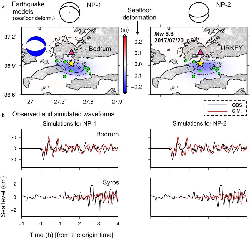
Heidarzadeh et al. Geosci. Lett. (2017) 4:31 Page 2 of 11
near-field around the city of Bodrum which flooded many
nearshore restaurants and damaged boats mainly in the
Gumbet bay (Yalçiner et al. 2017). A maximum runup of
1.5 m was observed in Kos Island (Yalçiner et al. 2017).
No death was reported due to the tsunami. Details of the
tsunami field survey are available in Yalçiner et al. (2017).
Tsunami warnings were disseminated by the Tsunami
Service Providers (TSPs) within the Intergovernmental
Coordination Group, North East Atlantic, Mediterranean
and Connected seas Tsunami Warning System (ICG/
NEAMTWS). The EMSC disseminated a twitter message
advising local people to avoid beaches, despite having no
mandate for disseminating such a message and being out
of their area of competence.
The epicentral region is an active seismic zone due to
the presence of three main tectonic plate borders: Afri-
can, Arabian, and Anatolian plates (Fig. 1). To the south
of the epicenter, the Hellenic subduction zone is sub-
ducting beneath the Anatolian microplate; to the east,
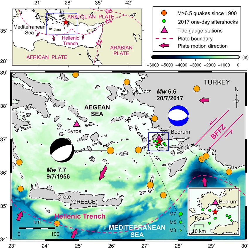
Fig. 1 Location map showing the epicenter (red star) and mecha-
the Anatolian microplate is in strike-slip motions along
nism of the 20 July 2017 Bodrum–Kos earthquake. Locations of two
tide gauges (Bodrum and Syros) are shown by pink triangles. Green its northeast and southeast boundaries with the Eura-
circles show 1-day aftershocks (M ≥ 4) from the USGS catalog. The sian and Arabian plates, respectively. As shown in Fig. 1,
mechanism for the 2017 event is taken from the USGS catalog. the 2017 Mw 6.6 event occurred as an intraplate earth-
Orange circles are M ≥ 6.5 earthquakes since 1900 AD obtained quake in the Aegean Sea region within the Anatolian
from the USGS catalog. The magnitude and mechanism of the 1956
microplate which is part of the Eurasian Plate. According
event is obtained from USGS and Okal et al. (2009), respectively. Plate
motion direction arrows and fault zones shown in this figure are to Kurt et al. (1999), the epicentral area is under a N–S
based on those in Ozel et al. (2011) and Ebeling et al. (2012). BFFZ extensional tectonic regime (35–40 mm/year according
Burdur–Fethiye fault zone to Ebeling et al. 2012) which is most probably attributed
to the westerly escape of the Anatolian plate in response
to the collision of the African, Eurasian, and Arab plates.
Following the 20 July 2017 earthquake, two major seis- At least 14M ≥ 6.5 earthquakes occurred in the region
mic clusters (clusters A and B, Fig. 2a) were triggered and since 1900 AD based on the USGS catalog (https://earth-
many aftershocks were generated in the source region quake.usgs.gov/earthquakes/search/). Among these large
(Fig. 2a). Approximately 1500 aftershocks with M ≥ 2.0 earthquakes, the largest one is the 9 July 1956 Amorgos
were observed on August 11, 2017 (Fig. 2b). The trig- event (M 7.7) (Fig. 1) which caused a death toll of 53 from
gered seismic cluster A was located approximately 30 km both earthquake and tsunami, and the observed tsu-
northeast of the mainshock which started on July 24, nami runup was up to 30 m (Ambraseys 1960; Okal et al.
2017 and included approximately 60M ≥ 2.0 earthquakes 2009). The most recent tsunami in the Mediterranean
(Fig. 2c). Cluster B was located at the northeastern edge basin occurred on March 21, 2003 produced by an Mw
of the source region which was typically activated on 7 6.9 earthquake onshore Algeria, causing runup of ~ 2 m
August and followed by the largest aftershock (Mw 5.1) and moderate damage (Alasset et al. 2006; Sahal et al.
in this sequence (as of August 11, 2017). Possible mech- 2009; Heidarzadeh and Satake 2013a).
anisms for the triggering of these seismic clusters are The July 2017 Bodrum–Kos earthquake and tsunami is
static stress changes imparted by the mainshock (e.g., analyzed in this study to add insights into tsunami haz-
Ishibe et al. 2015), the dynamic stress changes due to the ards in the Mediterranean basin by providing a source
passage of seismic waves (e.g., Hill et al. 1993), and/or model and conducting waveform and spectral analyses
decreases in failure strength due to increases in pore fluid as well as aftershock analysis. Although powerful tsuna-
pressure (e.g., Hubbert and Rubey 1959). mis from M > 8 earthquakes occur almost annually in
Based on the field surveys by Yalçiner et al. (2017), a the Pacific Ocean (e.g., Synolakis et al. 2002; Fritz et al.
moderate tsunami was generated following the earth- 2012; Suppasri et al. 2013; Satake 2014; Heidarzadeh
quake reaching a maximum runup of 1.9 m along a et al. 2016a; Shimozono and Sato 2016; Saito 2017; Ishibe
dry stream at Gumbet bay (West of Bodrum, Tur- et al. 2017), such events are less frequent in the Mediter-
key) and producing an average runup of ~ 0.6 m in the ranean Sea. Therefore, analysis of this moderate tsunami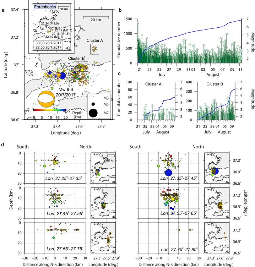
Heidarzadeh et al. Geosci. Lett. (2017) 4:31                                                                                               Page 3 of 11

  Fig. 2 Aftershock analysis for the 20 July 2017 Bodrum–Kos earthquake in Turkey. a Distribution of aftershocks (M ≥ 2.0, depth ≤ 100 km) from the
  catalog provided by AFAD (Disaster and Emergency Management Authority, Earthquake Department, Turkey). The color map of the circles shows
  the hypocentral depth. The inset shows the hypocenter distribution of foreshocks on the day of the 2017 Bodrum–Kos earthquake. b, c Cumulative
  frequency curve (blue) and magnitude–time diagram (green) for the entire region and for two seismic clusters of A and B, respectively. d Cross sec-
  tions of aftershock hypocenters at various longitude ranges (left panels) and their epicentral projections (right panels)

contributes toward tsunami assessment and awareness in                        tsunami phase velocity equation (Equation 5 in Heidar-
this enclosed basin and tests the functional performance                      zadeh and Satake 2015b). Information from aftershock
of TSPs in the NEAMTWS region. Here, we first report                          analysis and tsunami spectral analysis leads to effective
tide gauge records of the tsunami; second, conduct spec-                      tsunami simulations. We also discuss the response from
tral analyses to reveal spectral content of the tsunami;                      the operational national and regional tsunami warning
and third, perform numerical modeling of tsunami and                          systems in the Mediterranean Basin to this tsunami.
aftershock analysis to provide insights on the tsunami
source. Aftershock analysis helps to identify the loca-                       Data and methods
tion of the fault plane (e.g., 1-day aftershocks). It is widely               Two tide gauge records of the tsunami were used in
accepted to place the fault plane on the area around the                      this study at Bodrum (Turkey) and Syros (Greece)
epicenter where most of the aftershocks occurred (Satake                      located at distances of 13 and 230 km from the epi-
et al. 2013). Spectral analysis helps to estimate the dimen-                  center, respectively (see Fig. 1 for locations and Fig. 3
sions of the fault plane (length and width) using the                         for the waveforms). The Bodrum and Syros records have
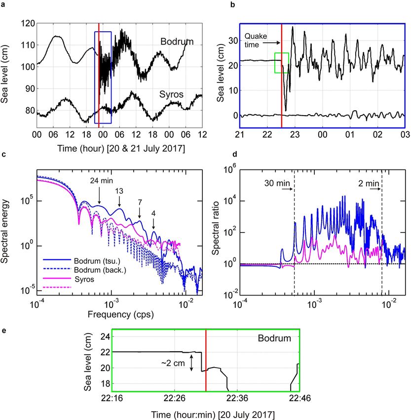
Heidarzadeh et al. Geosci. Lett. (2017) 4:31                                                                                                  Page 4 of 11

  Fig. 3 Original records a and de-tided waveforms b of the 20 July 2017 Bodrum–Kos tsunami in Bodrum (Turkey) and Syros (Greece). c, d Spectra
  and spectral ratios at these two stations. tsu and back represent tsunami and background signals, respectively. e The enlarged view of the green
  rectangle shown in (b). In (e), the seafloor uplift of ~ 2 cm looks occurring 30 s before the earthquake time. Obviously, the uplift occurred simultane-
  ously at the earthquake origin time (red vertical line); the 30 s shift can be attributed to the temporal resolution of the instrument

sampling intervals of 0.5 and 1 min, respectively. Tidal                        Satake 2014, 2015a, b; and Heidarzadeh et al. 2016a). For
signals were removed from the original records by fil-                          spectral ratio analysis, we applied the original tsunami
tering the time-series applying the Butterworth Infi-                           records rather than the filtered waveforms. The length
nite Impulse Response digital filters in Matlab with the                        of the background signal was the same as that of the tsu-
transfer coefficients of 5th-order and cutoff period of                         nami signal at each station. Waveform segments of 8 and
90 min (Mathworks 2017). For Fourier analysis, which                            3 h were used for the spectral ratio analyses at Bodrum
is a time-independent analysis, the Welch’s (1967) aver-                        and Syros stations, respectively.
aged modified-periodogram technique was applied using                             The tsunami numerical package of Satake (1995) was
time-series windows with length of 90 min and 50% of                            used here for tsunami simulations on the GEBCO-2014
overlaps. We also applied the spectral ratio concept of                         digital bathymetry with the resolution of 30 arc-seconds
Rabinovich (1997) to separate tsunami spectral con-                             (Weatherall et al. 2015). Time step was 1.0 s for linear
tent from non-tsunami sources by dividing the spectral                          simulations. As inundation on dryland was not included
powers of tsunami part of the waveforms to that of the                          in our simulations, such a bathymetry is adequate (e.g.,
background part (i.e., before tsunami arrival) (Vich and                        Heidarzadeh et al. 2016a). According to Heidarzadeh
Monserrat 2009; Rabinovich et al. 2013; Heidarzadeh and                         et al. (2016b), linear and non-linear tsunami simulations
Heidarzadeh et al. Geosci. Lett. (2017) 4:31                                                                                    Page 5 of 11

give similar results as long as the waves are prevented         Table 1 Earthquake fault parameters issued in the tsu-
from inundation on dryland. Initial coseismic seafloor          nami messages by various ICG/NEAMTWS TSPs operating
deformation was calculated using the Okada (1985) dis-          in the eastern Mediterranean Basin for the 20 July 2017
location model. Fault parameters of strike, dip, and rake       Bodrum–Kos earthquake
angles were based on the W-phase focal mechanism solu-                            CAT-INGV KOERI-         NOA/HL-       EMSC        USGS
tion of the USGS. Other fault parameters (length, width)                                   RETMC          NTWC
were calculated using empirical equations of Wells and          Origin time       22:31        22:31      22:31         22:31:11 22:31:11
Coppersmith (1994). Tsunami simulations were con-                (UTC)
ducted for seafloor deformation from both nodal planes          Magnitude         Mw 6.8       Mw 6.6     ML 6.4a       Mw 6.6b Mw 6.6
(NP) consisting of strike, dip, and rake angles of 285°, 39°,   Depth (km)        10           11         10            2           7
and − 73°, respectively, for NP-1 and respective values of      Lat (°N)          36.90        36.96      36.95c        36.96       36.929e
84°, 53°, and − 103° for NP-2. Length and width of the          Lon (°E)          27.46E       27.51      27.42   d
                                                                                                                        27.45       27.414
fault were fixed at 25 and 15 km and the slip value was         For comparison, revised parameters from EMSC and USGS are also provided
determined by using a trial-and-error approach and by           a
                                                                    Local magnitude
changing the slip value in the range of 0.3‒0.8 m, with the     b
                                                                    Initial value was 6.7
increment of 0.1 m, in order to match the observed and          c
                                                                    Initial value was 36.96
simulated tsunami records in the near-field (i.e., Bod-         d
                                                                    Initial value was 27.59
rum tide gauge). The quality of match between observa-          e
                                                                    Initial value was 36.925
tion and simulations was judged based on visual looks
at the simulated and observed waveforms. Top depth of
the source fault was taken as 7 km because a hypocen-           (Heidarzadeh et al. 2015c, 2016a). Such strong attenua-
tral depth of 2–11 km was reported by various agencies          tion of the tsunami amplitudes can be attributed to the
(Table 1). The fault planes NP-1 and NP-2 included the          numerous bathymetric features and islands existing in
epicenter. Locations of aftershocks guided the fault loca-      the region. Duration of tsunami oscillations is around
tion. The fault plane was placed on the area around the         1 day at the Bodrum station (Fig. 3a).
epicenter where most of the aftershocks occurred. We              Fourier analysis for both tsunami and background
acknowledge that the location of aftershocks can be asso-       signals reveals multiple peak periods at 24, 13, 7, and
ciated with some errors because we did not relocate the         4 min (Fig. 3c). Tsunami signals show significant larger
aftershocks for this study. The source model that we cal-       spectral energy levels at the aforesaid periods than the
culate here has a focal mechanism based on the USGS’s           background signals at both stations. By producing spec-
W-phase, is guided by the aftershock locations, and is          tral ratio plots (Fig. 3d), it is demonstrated that tsunami
confirmed with the tsunami tide gauge records.                  period band is 2–30 min. For comparison, tsunami wave
                                                                periods can be up to around 60 min for large tsunamis
Tsunami waveforms and physical properties                       such as the 2011 off-Tohoku (Japan) event (Heidarza-
Figure 3 presents the original tsunami records (Fig. 3a)        deh and Satake 2013b). It is worth noting that the value
and de-tided waveforms (Fig. 3b). The de-tided wave-            of spectral ratio is around one for the period > 30 min
forms reveal that the Bodrum tide gauge station was             indicating a classic case for tsunami spectral ratio stud-
uplifted ~ 2 cm due to the earthquake and thus the tide         ies. The value of tsunami spectral ratio is normally one
gauge record at Bodrum shows an immediate decrease of           for non-tsunami period bands (i.e., period > 30 min and
~ 2 cm (Fig. 3e). Such coseismic uplift of a tide gauge sta-    < 2 min). The multiple peaks and troughs existing in the
tion also was observed during the 2016 Kaikoura (New            background spectra and the spectral ratios are due to
Zealand) earthquake (Heidarzadeh and Satake 2017).              the stepwise nature of the background signals caused
Tsunami arrival is clear at the Bodrum station by initial       by rounding the tide gauge recordings to two decimal
depression wave, while it is not clear at the Syros sta-        places; they do not affect the overall results though they
tion. The maximum trough-to-crest tsunami amplitudes            affect the appearance of the plots. It can be inferred
are 34.1 and 3.3 cm at these two stations, respectively,        from Fig. 3d that the dominating tsunami period band is
indicating 20 times attenuation of tsunami amplitude            7–13 min because the maximum spectral energy is seen
for traveling 230 km from the epicenter to the Syros sta-       within this period band at both stations. Dominating tsu-
tion. Far-field tsunami propagation is a function of water      nami period band is referred to as the period band that
depth at the tide gauge location, source directivity, and       contains the maximum spectral energy as shown in tsu-
wave reflection and refraction along the tsunami path           nami spectra and spectral ratio plots (Fig. 3c, d).
Heidarzadeh et al. Geosci. Lett. (2017) 4:31 Page 6 of 11 Source model both NP-1 and NP-2. In general, both tsunami observa- Tsunami simulations and comparison with observed tions at Bodrum and Syros are fairly reproduced given waveforms are presented in Fig. 4 for both nodal planes the moderate size of the tsunami. At Bodrum, the tsu- NP-1 and NP-2 and for the slip value of 0.4 m. Slip nami period is reproduced well. Although the maxi- value of 0.4 m was determined after several simulations mum simulated depression amplitude is slightly smaller using slip range of 0.3‒0.8 m; this optimum slip value than that of observation, and the maximum simulated (i.e., 0.4 m) produced the best fit with the near-field elevation amplitude is slightly larger, the simulated tsunami observation at south of Bodrum peninsula trough-to-crest height is same as that of observation. both in terms of maximum depression and elevation Snapshots of tsunami propagation at different times waves. Best model means a source model that produces (Fig. 5) reveal strong scattering and reflections of the the closest match between tsunami observations and waves due to the bathymetric features which contrib- simulations both in terms of wave amplitudes and peri- ute to rapid dissipation of wave energy and amplitudes. ods. Assuming a rigidity of 3 × 10¹¹ dyne/cm2 such a This is possibly the reason for strong tsunami ampli- fault results in a seismic moment and a moment mag- tude attenuation in Syros at the distance of 230 km nitude of 4.5 × 1025 dyne-cm and 6.3, respectively. from the source. Calculated seafloor deformation (Fig. 4a) confirms The simulated waveforms from both NPs look similar 1–2 cm of coseismic uplift at the Bodrum station for which can be attributed to the small difference between Fig. 4 a Seafloor deformation from source models based on nodal planes 1 (left) and 2 (right) for slip values of 0.4 m for the 20 July 2017 Bodrum– Kos tsunami. Green circles show 1-day aftershocks (M ≥ 4) from the USGS catalog. b Comparison of observations (black) and simulations (red) for NP-1 (left) and NP-2 (right)
Heidarzadeh et al. Geosci. Lett. (2017) 4:31 Page 7 of 11
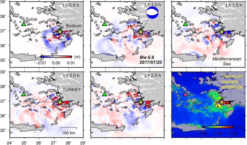
Fig. 5 Simulated snapshots at different times (the first five panels) and the maximum tsunami amplitude (the panel at bottom-right) for the 20 July
2017 Bodrum–Kos tsunami. These results are based on NP-1
coseismic seafloor deformation patterns obtained for and the preparedness of the general public and to pro-
the two NPs. Overall, tsunami simulations may indicate mote a better cooperation with the civil protection
that a fault with length, width, and slip of 25 km, 15 km, authorities (CPA). Regular communication tests and
and 0.4 m, respectively, was responsible for the July 2017 tsunami exercises, such as NEAMWAVE12 (http://
Bodrum–Kos tsunami. The current results are not capa- unesdoc.unesco.org/images/0021/002189/218990e.
ble of providing strong clues about which fault plane was pdf ), NEAMWAVE14 (http://unesdoc.unesco.org/
the actual plane of the earthquake source (either north- images/0023/002301/230172e.pdf ), and the most
erly or southerly dipping). Seismological studies includ- recent NEAMWAVE17 (http://unesdoc.unesco.org/
ing our aftershock-hypocenter analysis (Fig. 2d) and the images/0025/002591/259196E.pdf ) (November 2017)
finite-fault model by Saltogianni et al. (2017) also have enabled the incorporation of the derived improvements
not been able to resolve the fault plane. into strategic planning for the future of NEAMTWS.
Despite some limitations due to physical constraints, at
Response from tsunami warning systems the present time, a strong know-how and demonstrated
and discussions capabilities of upstream components of tsunami warning
Since the establishment of the ICG/NEAMTWS system exist within the NEAMTWS.
more than 10 years ago, steady progress has been During the 20 July 2017 tsunami event, all ICG/NEA-
achieved towards the provision of tsunami watch ser- MTWS tsunami service providers (TSPs), operating in
vices in the NEAM region (http://unesdoc.unesco.org/ the Eastern Mediterranean Basin, issued tsunami Watch/
images/0024/002473/247393m.pdf ). As of December Advisory, Ongoing, and End messages to their subscrib-
2017, France, Greece, Italy, and Turkey have National ers and national CPAs. TSP messages are not designated
Tsunami Warning Centers (NTWC) and act as TSPs. to be publicly available. To receive them, official request
Portugal is on the verge of similar capability. Spain has should be made by designated authorities of ICG/NEA-
established its NTWC, and Israel is expected to fol- MTWS member states through the IOC Secretariat. It
low in the near future. A Tsunami Information Centre is the designated national authority’s responsibility to
for the NEAM region (NEAMTIC) has been set-up to implement relevant systems and adopt corresponding
provide tools and products to increase the awareness standard operational procedures to further communicateHeidarzadeh et al. Geosci. Lett. (2017) 4:31 Page 8 of 11
the warnings to the public. TSPs that disseminated Warn- the potential for a tsunami where the expected wave
ing/Watch messages during the 20 July 2017 event were height at the coastline and/or tsunami runup are greater
CAT-INGV: Centro Allerta Tsunami Istituto Nazion- than 0.5 and 1 m, respectively (Interim Operational Users
ale di Geofisica e Vulcanologia (Italy); KOERI-RETMC: Guide of NEAMTWS: http://ioc-unesco.org/index.
Kandilli Observatory and Earthquake Research Institute- php?option=com_oe&task=viewDocumentRecord&docI
Regional Earthquake and Tsunami Monitoring Center D=8129). As for KOERI-RETMC and NOA/HL-NTWC,
(Turkey); and NOA/HL-NTWC: National Observatory the first warning messages were considerably delayed (19
of Athens-Hellenic National Tsunami Warning Cen- and 18 min after the origin time, respectively, Table 2).
tre (Greece). To define the alert levels, TSPs refer to the The alert levels of KOERI-RETMC and NOA/HL-NTWC
Decision Matrices (DM) embedded into their standard were same as CAT-INGV. Based on the observed tsu-
operational procedures. A DM is a set of empirical rules nami phenomena, we conclude that this alert level was
dealing with the possibility for tsunami generation based appropriate. Nevertheless, even if the desirable time limit
on the location of the epicenter, focal depth, and magni- of ~ 10 min was achieved by KOERI-RETMC and NOA/
tude (Interim Operational Users Guide of NEAMTWS: HL-NTWC for the issuance of the initial warning mes-
http://ioc-unesco.org/index.php?option=com_oe&ta sages, the other challenge would be the timely transfer
sk=viewDocumentRecord&docID=8129; Ozel et al. of the message to the public at risk through the CPAs. It
2011; Tinti et al. 2012; Papadopoulos 2015). While NOA/ should be further noted that timely and reliable warning
HL-NTWC utilizes the DM for the Mediterranean pro- messages require stable moment magnitude calculations
posed by the ICG/NEAMTWS in 2010, CAT-INGV and as well as quick expert assessment on the ground.
KOERI-RETMC use a modified and less conservative DM For most of the Eastern Mediterranean, tsunami hazard
in accordance with the recommendation of ICG/NEA- is a local (near-field) phenomenon and while the interna-
MTWS in 2016 to determine the threat level information tional and intergovernmental tsunami warning system
based on their best practices including scenario-based (i.e., NEAMTWS) addresses the requirements for basin-
tsunami databases. During the 2017 Bodrum–Kos event, wide tsunami threats, special focus is necessary for near-
the earthquake parameters calculated and reported by field tsunami threat due to its short arrival time (e.g.,
these warning centers are provided in Table 1 and issue Synolakis and Kong 2006; Synolakis and Bernard 2006;
times of these messages are given in Table 2. Papadopoulos and Fokaefs 2013). The near-field tsu-
The waves from the 20 July 2017 Bodrum–Kos tsu- nami threats are a challenge for tsunami warning systems
nami first receded around 5 min after the earthquake and around the world because of the short tsunami travel
then the first elevation wave arrived 12–13 min after the times (e.g., 15‒20 min) and incapability of the current
earthquake causing 60 m of inundation from the shore- technologies to accurately estimate earthquake magni-
line (Yalçıner et al. 2017). This is also confirmed by our tudes in such a short time (e.g., Ozaki 2011). It is believed
numerical simulations (Fig. 4b). The earliest warning was that the earthquake ground shaking is the first warning
a Watch message for local area (< 100 km distances) pro- message for the coastal communities in the area empha-
vided by CAT-INGV after 10 min from the origin time sizing the importance of tsunami awareness and educa-
(Table 2), whose initial Mw estimation differed 0.2 units tion for coastal communities (e.g., Synolakis and Okal
with respect to the final value. A Watch message indicates 2005; Satake 2014). The components of tsunami warning
systems in the near-field conditions of the Mediterranean
Basin have been discussed by a number of authors among
Table 2 Tsunami warning types and issue times of mes- which are Ozel et al. (2011), Papadopoulos and Fokaefs
sages disseminated by ICG/NEAMTWS TSPs operating (2013), and Necmioglu (2016).
in the Eastern Mediterranean Basin for the 20 July 2017
The Bodrum–Kos tsunami showed that it is neces-
Bodrum–Kos tsunami
sary to increase the number of tidal gauge stations and
Various TSPs CAT-INGV KOERI-RETMC NOA/HL-NTWC to establish offshore buoy measurement systems in the
within ICG/NEAMTWS
Mediterranean basin because very few tsunami measure-
WATCH Message time (h: 22:41 22:50 22:49 ment data are available for this event due to the sparse
min, UTC) distribution of the sea level stations. Moreover, there
Time interval after the 10 19 18 have been recent improvements in tsunami warning
origin time (min)
system technologies which may help to directly use the
ONGOING message time 01:02 23:32 01:53
(h: min, UTC)
tsunami measurements for efficient tsunami warnings
END message time (h: 01:46 01:30 02:37
in the near-field, e.g., tsunami assimilations (Gusman
min, UTC) et al. 2016). The implementation of such systems would
Earthquake origin time was July 20, 2017 at 22:31 UTC according to USGS
require strong collaboration between NEAMTWS TSPsHeidarzadeh et al. Geosci. Lett. (2017) 4:31 Page 9 of 11
at international level and all end users and local stake- CAT-INGV (Italy) at 10 min; KOERI-RETMC (Tur-
holders at national level. The recent 20 July 2017 Bod- key) at 19 min; and NOA/HL-NTWC (Greece) at
rum–Kos earthquake and tsunami has indicated one 18 min. Apart from CAT-INGV, the response from
more time that, regardless of the structure and capabili- the other two TSPs came relatively late (compared to
ties of tsunami warning systems, the effectiveness of any the desired time of ~ 10 min), given the complexities
near-field tsunami early warning depends on the aware- of real-time earthquake analysis for reliable deter-
ness, education, preparedness, and risk perception of the mination of Mw. It is argued that even if the warn-
general public in the coastal communities. Therefore, we ing time of ~ 10 min was achieved, it might not be
conclude that there is a need to focus on local tsunami sufficient in addressing near-field tsunami hazards.
early warning as part of the community programs sup- Despite considerable accomplishments of NEA-
ported by TSPs and other relevant stakeholders, such as MTWS since its establishment more than a decade
municipalities and local disaster and CPAs. This high- ago, the experience from this short arrival-time tsu-
lights the need for further efforts to effectively integrate nami highlights the need for further integration of
the downstream components of a tsunami warning sys- CPAs and promoting education and preparedness
tem, such as sirens of other means for disseminating programs for the people at risk as the tsunami hazard
tsunami alerts to the population by the CPAs. The pro- for the Mediterranean region is a near-field hazard.
cedures for evacuation planning and the need for CPAs In this regard, it would be advisable to identify these
to demonstrate and maintain the capability to effectively issues as strategic priorities for the development of
respond to a rare (but possibly devastating) event by NEAMTWS.
carrying out regular drills and exercises should be fur-
ther promoted within national programs. In this con-
Abbreviations
text, individual nations participating in the framework AFAD: Disaster and Emergency Management Authority, Earthquake Depart-
of ICG/NEAMTWS should also investigate the feasibil- ment, Government of Turkey; DM: decision matrices; EMSC: European-
ity of adopting education and preparedness programs Mediterranean Seismological Center; ICG/NEAMTWS: Intergovernmental
Coordination Group for the Tsunami Early Warning and Mitigation System in
such as the US National Weather Service TsunamiReady the Northeastern Atlantic; CAT-INGV: Centro Allerta Tsunami Istituto Nazionale
program (https://www.weather.gov/tsunamiready/) in di Geofisica e Vulcanologia (Italy); KOERI-RETMC: Kandilli Observatory and
NEAMTWS. Earthquake Research Institute- Regional Earthquake and Tsunami Monitor-
ing Center (Turkey); NOA/HL-NTWC: National Observatory of Athens-Hellenic
National Tsunami Warning Center (Greece); TSPs: Tsunami Service Providers.
Conclusions
The 20 July 2017 Bodrum–Kos earthquake (Mw 6.6) and Authors’ contributions
MH prepared the initial draft, conducted tsunami simulations and spectral
tsunami and the response from various Tsunami Service analysis, and produced relevant figures and texts. ON critically analyzed the
Providers in the NEAMTWS region were studied. The response from various Tsunami Service Providers (TSPs), prepared the two
main findings and concluding remarks are: tables, and wrote “Response from tsunami warning systems and discussions”.
TI performed aftershocks analysis, produced Fig. 2, and wrote the relevant
texts. ACY provided critical insights for the tsunami source, peak tsunami
1. The tsunami recorded a maximum trough-to-crest coastal amplitudes, wave motions, and the performance of the TSPs. All
height of 34.1 and 3.3 cm at the two tide gauge sta- authors read and approved the final manuscript.
tions of Bodrum (12 km from the epicenter) and Author details
Syros (230 km from the epicenter), respectively. The 1
Department of Civil and Environmental Engineering, Brunel University Lon-
maximum runup was 1.9 m in Bodrum. Duration of don, Uxbridge UB8 3PH, UK. 2 Kandilli Observatory and Earthquake Research
Institute, Bogazici University, Istanbul, Turkey. 3 Association for the Develop-
tsunami oscillations was around 1 day at the Bodrum ment of Earthquake Prediction, Tokyo, Japan. 4 Department of Civil Engineer-
station. Tsunami period band was 2–30 min with ing, Ocean Engineering Research Center, Middle East Technical University,
peak periods at 7–13 min. Ankara, Turkey.
2. Tsunami simulations using a fault model having Acknowledgements
length and width of 25 and 15 km, respectively, slip of The manuscript benefited from constructive comments by Prof. Kenji Satake
0.4 m, and fault parameters from both nodal planes (Editor-in-Chief ) before submission for which we are sincerely grateful. MH
thanks Dr. Gerassimos A. Papadopoulos (National Observatory of Athens,
(NP-1: strike, 285°; dip, 39°; and rake, − 73° and Greece) for fruitful discussions on this event during the 2017 International Tsu-
respective values of 84°, 53°, and − 103° for NP-2) nami Symposium in Bali, Indonesia. The authors would also like to thank all of
almost equally reproduced the tsunami observations. the organizations mentioned in the “Availability of data and materials” section,
which provided the data and information used in this study. The manuscript
Tsunami simulation was unable to resolve the fault benefited from review comments made by three reviewers appointed by the
plane; our aftershock-hypocenter analysis also failed journal (Dr. Stefano Lorito and two anonymous reviewers) for which we are
to do so. sincerely grateful.
3. Three ICG/NEAMTWS TSPs supplied tsunami Competing interests
warnings following this event at different times: The authors declare that they have no competing interests.Heidarzadeh et al. Geosci. Lett. (2017) 4:31 Page 10 of 11
Availability of data and materials Heidarzadeh M, Murotani S, Satake K, Ishibe T, Gusman AR (2016b) Source
IOC sea level monitoring facility (http://www.ioc-sealevelmonitoring.org/) model of the 16 September 2015 Illapel, Chile Mw 8.4 earthquake based
was used for the tide gauge records. Data providers are General Command on teleseismic and tsunami data. Geophys Res Lett 43(2):643–650
of Mapping for Bodrum (Turkey) and Hellenic Navy Hydrographic Service for Hill DP, Reasenberg PA, Michael A, Arabaz WJ, Beroza G, Brumbaugh D, Brune
Syros (Greece) tide gauge stations. Aftershocks data are from the catalog pro- JN, Castro R, Davis S, dePolo D, Ellsworth WL, Gomberg J, Harmsen S,
vided by AFAD (Disaster and Emergency Management Authority, Earthquake House L, Jackson SM, Johnston MJS, Jones L, Keller R, Malone S, Munguia
Department, Government of Turkey) (https://www.afad.gov.tr/en/). We also L, Nava S, Pechmann JC, Sanford A, Simpson RW, Smith RB, Stark M, Stick-
used Generic Mapping Tools (Wessel and Smith 1998) for drawing figures ney M, Vidal A, Walter S, Wong V, Zollweg J (1993) Seismicity remotely
(http://gmt.soest.hawaii.edu/). triggered by the magnitude 7.3 Landers, California, earthquake. Science
260:1617–1623
Ethics approval and consent to participate Hubbert MK, Rubey WW (1959) Role of fluid pressure in mechanics of over-
Not applicable. thrust faulting, 1. Mechanics of fluid-filled porous solids and its applica-
tion to overthrust faulting. Geol Soc Am Bull 70:115–166
Funding Ishibe T, Satake K, Sakai S, Shimazaki K, Tsuruoka H, Yokota Y, Nakagawa S,
MH is grateful to the Brunel University London for the funding provided Hirata N (2015) Correlation between Coulomb stress imparted by the
through the Brunel Research Initiative and Enterprise Fund 2017/18 (BUL 2011 Tohoku-oki earthquake and seismicity rate change in Kanto, Japan.
BRIEF). Geophys J Int 201:112–134
Ishibe T, Ogata Y, Tsuruoka H, Satake K (2017) Testing the Coulomb stress
triggering hypothesis for three recent megathrust earthquakes. Geosci
Publisher’s Note Lett 4:5
Springer Nature remains neutral with regard to jurisdictional claims in pub- Kurt H, Demirbağ E, Kuşçu İ (1999) Investigation of the submarine active tec-
lished maps and institutional affiliations. tonism in the Gulf of Gökova, southwest Anatolia–southeast Aegean Sea,
by multi-channel seismic reflection data. Tectonophysics 305(4):477–496
Received: 7 September 2017 Accepted: 6 December 2017 Mathworks (2017) MATLAB user manual. The Math Works Inc., MA, p 282
Necmioğlu Ö (2016) Design and challenges for a tsunami early warning
system in the Marmara Sea. Earth Planets Space 68:13. https://doi.
org/10.1186/s40623-016-0388-2
Okada Y (1985) Surface deformation due to shear and tensile faults in a half-
space. Bul Seismol Soc Am 75:1135–1154
References
Okal EA, Synolakis CE, Uslu B, Kalligeris N, Voukouvalas E (2009) The 1956 earth-
Alasset PJ, Hébert H, Maouche S, Calbini V, Meghraoui M (2006) The tsunami
quake and tsunami in Amorgos, Greece. Geophys J Int 178(3):1533–1554
induced by the 2003 Zemmouri earthquake (Mw = 6.9, Algeria): model-
Ozaki T (2011) Outline of the 2011 off the Pacific coast of Tohoku Earthquake
ling and results. Geophys J Int 166:213–226
(Mw 9.0). Earth Planets Space 63(7):57
Ambraseys NN (1960) The seismic sea wave of July 9, 1956 in the Greek archi-
Ozel NM, Necmioglu O, Yalciner AC, Kalafat D, Erdik M (2011) Tsunami hazard
pelago. J Geophys Res 65:1257–1265
in the eastern Mediterranean and its connected seas: toward a tsunami
Ebeling CW, Okal EA, Kalligeris N, Synolakis CE (2012) Modern seismological
warning center in Turkey. Soil Dyn Earthq Eng 31(4):598–610
reassessment and tsunami simulation of historical Hellenic Arc earth-
Papadopoulos GA (2015) Tsunamis in the European-Mediterranean region:
quakes. Tectonophysics 530:225–239
from historical record to risk mitigation. Elsevier, Amsterdam, p 290. ISBN
Fritz HM, Phillips DA, Okayasu A, Shimozono T, Liu H, Mohammed F, Skanavis V,
978-0-12-420224-5
Synolakis CE, Takahashi T (2012) The 2011 Japan tsunami current velocity
Papadopoulos GA, Fokaefs A (2013) Near-field tsunami early warning and
measurements from survivor videos at Kesennuma Bay using LiDAR.
emergency planning in the Mediterranean Sea. Res Geophys 3:24–31
Geophys Res Lett. https://doi.org/10.1029/2011GL050686
Rabinovich AB (1997) Spectral analysis of tsunami waves: separation of source
Gusman AR, Sheehan AF, Satake K, Heidarzadeh M, Mulia IE, Maeda T
and topography effects. J Geophys Res 102(C6):12663–12676
(2016) Tsunami data assimilation of Cascadia seafloor pressure gauge
Rabinovich AB, Candella RN, Thomson RE (2013) The open ocean energy decay
records from the 2012 Haida Gwaii earthquake. Geophys Res Lett
of three recent trans-Pacific tsunamis. Geophys Res Lett 40:3157–3162
43(9):4189–4196
Sahal A, Roger J, Allgeyer S, Lemaire B, Hébert H, Schindelé F, Lavigne F (2009)
Heidarzadeh M, Satake K (2013a) The 21 May 2003 tsunami in the western
The tsunami triggered by the 21 May 2003 Boumerdes–Zemmouri (Alge-
Mediterranean Sea: statistical and wavelet analyses. Pure Appl Geophys
ria) earthquake: field investigations on the French Mediterranean coast
170(9):1449–1462
and tsunami modelling. Nat Haz Earth Sys Sci 9(6):1823
Heidarzadeh M, Satake K (2013b) Waveform and spectral analyses of the 2011
Saito T (2017) Tsunami generation: validity and limitations of conventional
Japan tsunami records on tide gauge and DART stations across the
theories. Geophys J Int 210(23):1888–1900
Pacific Ocean. Pure Appl Geophys 170(6):1275–1293
Saltogianni V, Taymaz T, Yolsal-Çevikbilen S, Eken T, Gianniou M, Öcalan T,
Heidarzadeh M, Satake K (2014) Excitation of basin-wide modes of the Pacific
Pytharouli S, Stiros S (2017) Fault-model of the 2017 Kos-Bodrum (east
Ocean following the March 2011 Tohoku tsunami. Pure Appl Geophys
Aegean Sea) Mw 6.6 earthquake from inversion of seismological and
171(12):3405–3419
GPS data—preliminary report. http://web.itu.edu.tr/~taymaz/docs/2017-
Heidarzadeh M, Satake K (2015a) Source properties of the 17 July 1998
SALTOGIANNI-TAYMAZ-ETAL-KOS-BODRUM-EARTHQUAKE-PRELIMINARY-
Papua New Guinea tsunami based on tide gauge records. Geophys J Int
REPORT.pdf. Accessed on 4 Dec 2017
202(1):361–369
Satake K (1995) Linear and nonlinear computations of the 1992 Nicaragua
Heidarzadeh M, Satake K (2015b) New insights into the source of the Makran
earthquake tsunami. Pure Appl Geophys 144:455–470
tsunami of 27 November 1945 from tsunami waveforms and coastal
Satake K (2014) Advances in earthquake and tsunami sciences and disaster risk
deformation data. Pure Appl Geophys 172(3–4):621–640
reduction since the 2004 Indian ocean tsunami. Geosc Lett 1(1):15
Heidarzadeh M, Satake K (2017) Possible dual earthquake-landslide source
Satake K, Fujii Y, Harada T, Namegaya Y (2013) Time and space distribution of
of the 13 November 2016 Kaikoura, New Zealand Tsunami. Pure Appl
coseismic slip of the 2011 Tohoku earthquake as inferred from tsunami
Geophys 174(10):3737–3749
waveform data. Bull Seismol Soc Am 103(2B):1473–1492
Heidarzadeh M, Satake K, Murotani S, Gusman AR, Watada S (2015) Deep-
Shimozono T, Sato S (2016) Coastal vulnerability analysis during tsunami-
water characteristics of the trans-Pacific tsunami from the 1 April 2014
induced levee overflow and breaching by a high-resolution flood model.
Mw 8.2 Iquique, Chile earthquake. Pure Appl Geophys 172(3):719–730
Coastal Eng 107:116–126
Heidarzadeh M, Harada T, Satake K, Ishibe T, Gusman AR (2016a) Comparative
Suppasri A, Shuto N, Imamura F, Koshimura S, Mas E, Yalciner AC (2013) Les-
study of two tsunamigenic earthquakes in the Solomon Islands: 2015 Mw
sons learned from the 2011 Great East Japan tsunami: performance of
7.0 normal-fault and 2013 Santa Cruz Mw 8.0 megathrust earthquakes.
tsunami countermeasures, coastal buildings, and tsunami evacuation in
Geophys Res Lett 43(9):4340–4349
Japan. Pure Appl Geophys 170(6–8):993–1018Heidarzadeh et al. Geosci. Lett. (2017) 4:31 Page 11 of 11
Synolakis CE, Bernard EN (2006) Tsunami science before and beyond Boxing model of the world’s oceans. Earth Space Sci 2:331–345. https://doi.
Day 2004. Phil Trans R Soc Lon A 364(1845):2231–2265 org/10.1002/2015EA000107
Synolakis CE, Kong L (2006) Runup measurements of the December 2004 Welch P (1967) The use of fast Fourier transform for the estimation of power
Indian Ocean tsunami. Earthq Spectra 22(S3):67–91 spectra: a method based on time averaging over short, modified peri-
Synolakis CE, Okal EA (2005) 1992–2002: Perspective on a decade of post- odograms. IEEE Trans Audio Electroacoust 15:70–73
tsunami surveys. In: Satake K (ed) Tsunamis: case studies and recent Wells DL, Coppersmith KJ (1994) New empirical relationships among magni-
developments, 23rd edn., pp 1–30 tude, rupture length, rupture width, rupture area, and surface displace-
Synolakis CE, Bardet JP, Borrero JC, Davies HL, Okal EA, Silver EA, Sweet S, Tap- ment. Bull Seismol Soc Am 84(4):974–1002
pin DR (2002) The slump origin of the 1998 Papua New Guinea tsunami. Wessel P, Smith WHF (1998) New, improved version of generic mapping tools
Proc R Soc Lon A 458(2020):763–789 released. EOS Trans AGU 79(47):579. https://doi.org/10.1029/98EO00426
Tinti S, Graziani L, Brizuela B, Maramai A, Gallazzi S (2012) Applicability of the Yalçıner AC, Annunziato A, Papadopoulos G, Dogan GG, Guler HG, Cakir TE,
decision matrix of North Eastern Atlantic, Mediterranean and connected Sozdinler CO, Ulutas E, Arikawa T, Suzen L, Kanoglu U, Guler I, Probst P,
seas Tsunami Warning System to the Italian tsunamis. Nat Hazards Earth Synolakis C (2017) The 20th July 2017 (22:31 UTC) Bodrum/Kos earth-
Sys Sci 12:843–857 quake and tsunami; post tsunami field survey report. http://users.metu.
Vich MM, Monserrat S (2009) Source spectrum for the Algerian tsunami of edu.tr/yalciner/july-21-2017-tsunami-report/Report-Field-Survey-of-July-
21 May 2003 estimated from coastal tide gauge data. Geophys Res Lett 20-2017-Bodrum-Kos-Tsunami.pdf. Accessed on 4 Dec 2017
36:L20610
Weatherall P, Marks KM, Jakobsson M, Schmitt T, Tani S, Arndt JE, Rovere
M, Chayes D, Ferrini V, Wigley R (2015) A new digital bathymetricYou can also read