Cape York cassowaries: traditional owners recording populations and addressing threats to habitat
←
→
Page content transcription
If your browser does not render page correctly, please read the page content below
CSIRO LAND AND WATER

Cape York cassowaries: traditional owners recording
populations and addressing threats to habitat

Matt Bradford1, Naomi Hobson3, Eldine Creek3, Tim Jaffer3, Justin Perry2, David Westcott1

1
 CSIRO Land and Water, Atherton, QLD
2
 CSIRO Land and Water, Townsville, QLD
3
 Kalan Enterprises, Coen, Cape York, QLD
24th August 2018
Project report to the Australian Department of Environment and Energy (TSRF–EC‐03)

2 | Bradford et al. Cape York cassowaries
Citation
Bradford M, Hobson N, Creek E, Jaffer T, Perry J and Westcott D (2018) Cape York cassowaries:
traditional owners recording populations and addressing threats to habitat. Project report to the
Australian Department of Environment and Energy. CSIRO, Australia.

Copyright
© Commonwealth Scientific and Industrial Research Organisation 2018. To the extent permitted
by law, all rights are reserved and no part of this publication covered by copyright may be
reproduced or copied in any form or by any means except with the written permission of CSIRO.

Important disclaimer
CSIRO advises that the information contained in this publication comprises general statements
based on scientific research. The reader is advised and needs to be aware that such information
may be incomplete or unable to be used in any specific situation. No reliance or actions must
therefore be made on that information without seeking prior expert professional, scientific and
technical advice. To the extent permitted by law, CSIRO (including its employees and consultants)
excludes all liability to any person for any consequences, including but not limited to all losses,
damages, costs, expenses and any other compensation, arising directly or indirectly from using this
publication (in part or in whole) and any information or material contained in it.
CSIRO is committed to providing web accessible content wherever possible. If you are having
difficulties with accessing this document please contact csiroenquiries@csiro.au.

                                                                       Bradford et al. Cape York cassowaries | 3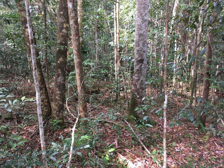
Contents

List of figures         ............................................................................................................................... 5
List of tables          ............................................................................................................................... 5
Acknowledgements ......................................................................................................................... 5

1          Introduction ........................................................................................................................ 6
2          Methodology ....................................................................... Error! Bookmark not defined.
           2.1         The southern cassowary and study site ................................................................ 8
           2.3         Field surveys .......................................................................................................... 9
           2.4         Habitat use and preference ................................................................................. 10
           2.5         Resource availability ............................................................................................ 10
3          Results ............................................................................................................................. 12
           3.1         Field surveys ........................................................................................................ 12
           3.2         Habitat use and preference ................................................................................. 12
           3.3         Resource availabilty ............................................................................................. 14
           3.4         Threats ................................................................................................................. 15
4          Discussion ......................................................................................................................... 16
           4.1         Cassowary distribution and population health ................................................... 16
           4.2         Habitat preference .............................................................................................. 16
           4.3         Threats ................................................................................................................. 17
           4.4         Implications ......................................................................................................... 17
Appendix A             Broad habitat type descriptions .......................................................................... 19
References              ........................................................................................................................... 244

4 | Bradford et al. Cape York cassowaries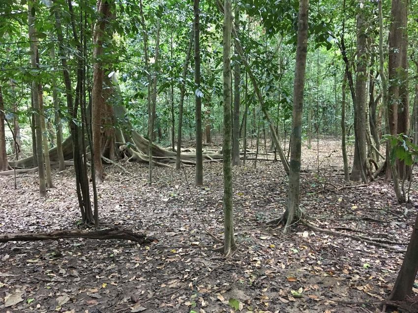
Figures
Figure 1 The McIlwraith Range showing land tenure. .................................................................... 7
Figure 2 The ten search areas on the McIlwraith Range showing the survey tracks. .................... 9
Figure 3 The probability of cassowary presence in each broad habitat type based on numbers of
signs encountered and length of track walked in each habitat type……………………………………………13
Figure 4a The relationship between the fleshy fruit richness and the number of recent
cassowary signs (r2 = 0.34, P = 0.10). ............................................................................................ 14
Figure 4b The relationship between fleshy fruit abundance and the number of recent cassowary
signs (r2 = 0.44, P = 0.05). .............................................................................................................. 15
Apx Figure A.1 An example of woodland habitat ......................................................................... 19
Apx Figure A.2 An example of vine thicket habitat...................... Error! Bookmark not defined.20
Apx Figure A.3 An example of gallery rainforest habitat ............. Error! Bookmark not defined.21
Apx Figure A.4 An example of moist rainforest habitat ............................................................... 22
Apx Figure A.5 An example of wet rainforest habitat ................. Error! Bookmark not defined.23

Tables
Table 1 The 10 areas surveyed for cassowary sign ....................................................................... 10
Table 2 The number of cassowary signs encountered in the 10 search areas ............................. 12
Table 3 Fleshy fruit richness and abundance in each survey area ................. Error! Bookmark not
defined.14

Acknowledgments
This study was undertaken on land belonging to the Kaantju and Lama Lama people. A large
number of Kalan rangers and members of the Coen community conducted the surveys: Dylan
Creek, Terry Creek, Sebastian Creek, Louican Creek, Dallas Harold, Walter Peter, Isaac Rokeby,
Francis Creek, Puchaanu Creek, Anita Platt. Thanks to Allan Creek Snr., James Creek and Jenny
Creek for guidance on country. We thank Brian Ross for logistical support. The study was carried
out for the Department of Environment and Energy with funding from the Threatened Species
Recovery Fund.

                                                                                                         Bradford et al. Cape York cassowaries | 5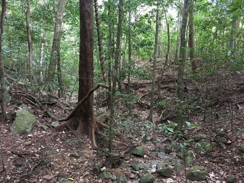
1                Introduction

Areas of continuous rainforest on Cape York Peninsula large enough to support cassowary
populations are limited to the Iron and McIlwraith Ranges, Jardine River National Park near
Heathlands, and north of Bamaga on the far northern peninsula. These areas are of small extent
relative to suitable habitat in Papua New Guinea to the north and the Wet Tropics bioregion to the
south and are highly naturally fragmented. Moreover, Cape York has a seasonal climate which
results in a distinctive flora and an annual resource bottleneck. For resident cassowaries this is
likely to result in a unique diet, habitat use and population density.
This study focuses on the cassowary population on the McIlwraith Range of eastern central Cape
York. The McIlwraith Range is included in the KULLA Land Trust and forms part of traditional lands
of the Kaantju, Umpila, Lama Lama and Ayapathu people (figure 1). Traditional Owners are aware
of a significant population of cassowaries on the Range and have a connection to the bird as a
totem animal represented in stories and art. Little is known about current Cape York cassowary
populations and threats to their survival. This study aims to build capacity amongst Traditional
Owner groups of the McIlwraith Range to document cassowary populations on their country by
developing a scientifically based survey methodology leading to cassowary knowledge being
explicitly considered in land management programs.
The study specifically aims to a) provide an overview of cassowary population health, b) determine
the current distribution and identify key habitat types, and c) identify current and future threats.
This is achieved through the marriage of traditional owner knowledge and resources, and the
latest scientific methodology and technology. The study addresses a number of Cassowary
Recovery Plan actions (Latch 2007), specifically (1.2) Identify and prioritise areas of essential
habitat for protection and management, (3.3) Assess potential impacts of pigs on cassowaries,
(3.4) Support existing planning and management strategies that target pests and weeds in
cassowary habitat, (5.2) Establish and implement a monitoring protocol in key habitat areas, (5.3)
Assess the size of Wet Tropics and Cape York populations and develop population viability models,
(7.3) Ensure aboriginal communities participate in all aspects of the recovery process, (7.4)
Document traditional cultural knowledge of cassowaries.

6 | Bradford et al. Cape York cassowaries
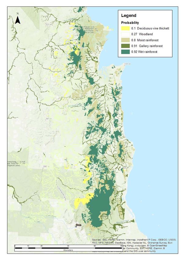
Figure 1. The McIlwraith Range showing the KULLA Land Trust and KULLA National Park as the major land
tenures of the area.

                                                                          Bradford et al. Cape York cassowaries | 7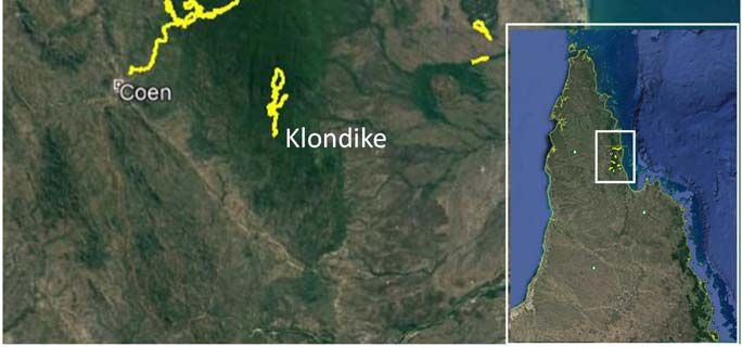
2                Methodology

2.1              The southern cassowary and study site
The southern cassowary has a range from New Guinea in the north to the Wet Tropics region of
Queensland in the south. Areas of continuous rainforest in New Guinea and to a lesser extent in
the Wet Tropics of Queensland are extensive and support a large and healthy population of
cassowaries. Westcott et al. (2014) estimated a stable population of approximately 4400
individuals in the Wet Tropics region. The cassowary population on Cape York Peninsula has
received little attention and population numbers are unknown. Our study area is the McIlwraith
Range and associated coastal plains which we define as ranging from the Stewart River in the
south (14.10S) to the headwaters of the Archer River in the north (13.50S). To the south of the
McIlwraith Range there is no suitable cassowary habitat for 200 km until Cooktown. To the north
there is a mosaic of continuous suitable habitat for at least 100 km.
The McIlwraith Range rises to 810 m asl and has extensive areas of evergreen, semi deciduous and
deciduous rainforest on granite, metamorphic, beach sand and alluvium (Queensland Government
2017). Areas of rainforest are highly fragmented by woodland due to the topography and resulting
climate. For this study the vegetation is classified into five broad habitat types; woodland, vine
thicket, gallery rainforest, moist rainforest and wet rainforest (Appendix 1). Across the study area
there are extensive areas of woodland featuring both advanced and recent encroachment of
rainforest.

8 | Bradford et al. Cape York cassowaries
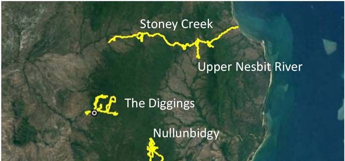
Figure 2. The ten search areas on the McIlwraith Range showing the survey tracks.

2.2         Field surveys
Surveys were conducted in areas distributed across the McIlwraith Range area in or adjacent to
rainforest (figure 2). Search areas were chosen to sample the habitat type and altitudinal range of
the study area while incorporating areas of cultural significance. The track length within search
areas ranged from 18 km to 87 km (table 1) with a mean of 42 km. Surveys were conducted by
two to four people either walking along existing tracks, following compass bearings or walking
along watercourses. The average search width is estimated at two metres either side of the track.
On sections of the Stoney Creek and Upper Peach Creek area, the track was traversed either by
four wheeler or car. In these cases one or more passengers scanned the track and its verge while
the vehicle moved at speeds
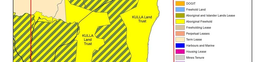
Table 1. The areas surveyed for cassowary sign.
                                                          Track
                                                         length   Western   Eastern   Northern   Southern
          Area                          Date surveyed     (km)    extent    extent     extent     extent
 Lankelly Creek                    October 2013            41     143.24    143.31     ‐13.87      ‐13.9
 The Diggings                      August/October 2014     43     143.25    143.31     ‐13.47     ‐13.50
 Stoney Creek                      October 2014            46     143.35    143.54     ‐13.36     ‐13.39
 Peach Creek                       July 2015               18     143.27    143.37     ‐13.70     ‐13.74
 Klondike                          October 2015            25     143.33    143.34     ‐13.93     ‐13.99
 Rocky River                       October 2015            87     143.44    143.52     ‐13.80     ‐13.93
 Upper Peach Creek                 October 2017            31     143.33    143.38     ‐13.73     ‐13.76
 Upper Nesbit River                November 2017           49     143.43    143.49     ‐13.37     ‐13.40
 Nullunbidgy                       January 2018            43     143.37    143.39     ‐13.55     ‐13.58
 Lower Leo Creek                   May 2018                38     143.37    143.41     ‐13.56     ‐13.62

As tracks were traversed, the following forms of cassowary sign were searched for; 1) sightings of
birds, 2) vocalisations, 3) feathers, 4) footprints, 5) fresh dung (estimated to be 1 month old). When a sign was detected it was recorded along with a GPS
coordinate, date and time. Additional information for sightings included the number and age of
the birds where possible. Motion activated cameras with colourful plastic lures (McLean et al.
2017) were positioned on the Upper Nesbit River area between October 2017 and May 2018 for a
total of 1140 camera days.
Traditional Owner rangers were trained with cassowary sign identification and data recording and
mapping tools including Cape York NRM’s Fulcrum Fire Management Application. At each search
area rangers qualitatively recorded threatening processes, notably weed, pig and cattle numbers
and damage. Discussions were also held with rangers and elders as to what they perceived as the
main threats to cassowaries both at the present and in the future. This was combined with counts
from camera images to identify threats to cassowaries and their habitat.

2.3              Habitat use and preference
To determine habitat use and preference by the cassowary the position of each cassowary sign
was assigned to one of the five broad habitat types when in the field. The surveyed tracks were
then overlayed on Google Earth and the length of track occurring in each broad habitat was
measured. To calculate habitat preference, the track length in each habitat type was recorded to
the nearest km and associated with cassowary sightings. Sections of track were broken into 1km
blocks and number of sightings per 1km block were derived. Cassowary sign was regressed against
1km blocks in each habitat type to record a probability of cassowary sign for each habitat type. An
inverse logit function was applied to the coefficients to get a probability value for each habitat
type. Camera images were not considered in this analysis due to biased placement in habitat and
survey area.

2.4              Resource availability
The majority of the cassowary’s diet is comprised of fruit, supplemented with fungi, flowers,
vertebrates and invertebrates (Bradford et al. 2008). To estimate resource availability for
cassowaries a list of fruiting species was compiled at each search area from observations and

10 | Bradford et al. Cape York cassowaries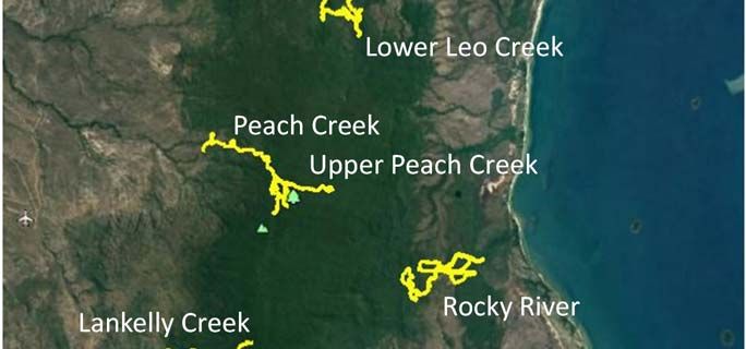
identifiable fruit in fresh dung. For each fleshy fruited species a relative abundance across the
landscape was recorded; a score of one was given to a species with one to a few fruit and a score
of ten given to a species with millions of fruit present across the landscape. Within a search area
the species scores were added to derive an abundance score. Fruit was not recorded at Lankelly
Creek. To explore the relationship between fruit availability and cassowary sign the fruiting
richness and abundance was compared to the density of cassowary signs in each search area. Only
recent signs (fresh dung, footprints, sightings and vocalisations) in primary habitat (gallery, moist
and wet rainforest) were included.

                                                                        Bradford et al. Cape York cassowaries | 11
3 Results
3.1 Field surveys
A total of 169 cassowary signs were encountered over 421 km of tracks across the 10 search areas
(table 2). This sign comprised of 40 fresh dungs, 77 old dungs, 42 sets of tracks, 9 individuals
sighted, 1 vocalisation and 0 feathers. Cassowary sign was encountered in all search areas except
Lankelly Creek. In 2018 a cassowary was sighted in woodland to the west of the Lankelly Creek
search area and was included in the study. The motion activated cameras captured four adult
cassowaries.
Table 2. The number of cassowary signs encountered in the 10 search areas.
fresh old Signs per km of
Transect dungs dungs tracks sightings vocalisations track
Lankelly Creek 0 0 0 1 0 0.02
The Diggings 2 1 4 0 0 0.16
Stoney Creek 0 5 2 0 0 0.15
Peach Creek 0 16 1 0 0 0.94
Klondike 2 8 3 2 0 0.60
Rocky River 22 18 13 5 0 0.67
Upper Peach Creek 4 10 11 0 0 0.81
Upper Nesbit River 4 8 0 0 0 0.24
Nullunbidgey 3 11 2 1 1 0.42
Lower Leo Creek 0 4 5 0 0 0.24
3.2 Habitat use and preference
While cassowary sign was encountered in all five habitat types, higher probabilities of
encountering sign were calculated for gallery (probability = 0.91 ± 0.76SE), moist (0.80 ± 0.76) and
wet rainforest (0.92 ± 0.78). Consequently, wet, moist and gallery rainforest are considered
primary cassowary habitat while vine thicket (probability = 0.10 ± 0.74SE) and woodland (0.27 ±
0.98) are considered secondary habitat, see Department of Environment and Resource
Management (2009). The probability value for each habitat type was applied to all regional
ecosystems (Queensland Government 2017) within that habitat type (appendix A) to produce
Figure 3.
12 | Bradford et al. Cape York cassowariesFigure 3. The probability of cassowary presence in each broad habitat type based on numbers of signs
encountered and length of track walked in each habitat type. The map is extended north to the Iron Range
to demonstrate the connectivity of primary habitat.
Bradford et al. Cape York cassowaries | 133.3 Resource availability
Fleshy fruiting species were recorded in all survey areas however the number and abundance
scores varied greatly due to the particular year, the season and the dominant habitat (table 3).
There was a weak positive relationship between both fruiting richness and abundance and the
number of recent cassowary signs (figure 4a,b), driven largely by high numbers of cassowary sign
and high fruit abundance at Klondike and Rocky River, areas which were surveyed one week apart.
The relationship was weakened by high fruit abundance and low numbers of cassowary sign at
Stoney Creek.
Table 3. Fleshy fruit richness and abundance in each survey area.
Number of fleshy fruiting Sum of fruit abundance
Survey area species scores
Lankelly Creek NA NA
The Diggings 10 27
Stoney Creek 18 48
Peach Creek 6 14
Klondike 23 59
Rocky River 20 65
Upper Peach Creek 6 18
Upper Nesbit River 9 23
Nullunbidgy 6 11
Lower Leo Creek 5 11
0.8
Recent cassowary signs per km
0.6
0.4
0.2
0.0
0 5 10 15 20
Number of fruiting species
Figure 4a. The relationship between the number of fleshy fruit species and number of recent cassowary
signs per km of track (r2 = 0.34, P = 0.10).
14 | Bradford et al. Cape York cassowariesRecent cassowary signs per km 0.8
0.6
0.4
0.2
0.0
0 10 20 30 40 50 60 70
Fruit abundance score
Figure 4b. Relationship between fleshy fruit abundance and number of recent cassowary signs per km of
track (r2 = 0.44, P = 0.05).
3.4 Threats
Feral pigs were sighted in all 10 survey areas. Pig rooting was seen in all areas and was present in
all broad habitat types, although most commonly observed in gallery rainforest. The motion
activated cameras captured 512 pigs (0.45/day) including 64 piglets. Feral cattle were seen in all
10 survey areas. The motion activated cameras captured 388 cattle (0.34/day). Rangers and elders
considered feral pigs and cattle to be the biggest threat to cassowaries and cassowary habitat on
the McIlwraith Range.
Exotic plant species observed in survey areas were Knobweed (Hyptis capitata), Giant rat‐tail grass
(Sporobolus spp.), Lantana (Lantana camara), Grader grass (Heteropogon quadrivalvis),
Snakeweed (Stachytarpheta spp.) and Mango (Mangifera indica). No weed species were common
under the closed canopy of the rainforest. Myrtle rust was observed on Tristaniopsis exiliflora and
Gossia grayi at Upper Peach Creek in wet rainforest although infestations were localised and
minor.
Bradford et al. Cape York cassowaries | 154 Discussion 4.1 Cassowary distribution and population health Our surveys found evidence of cassowaries across the extent of the McIlwraith Range. The failure to find cassowary sign in the Lankelly Creek area despite a reasonable search effort does not indicate an absence of cassowaries. Sign was common in the nearby Klondike area and a bird was sighted near Lankelly Creek in 2018 indicating that cassowaries are present in the southern section of the range. We found signs of cassowaries from near sea level to 720 m altitude. The McIlwraith Range has extensive areas of continuous primary and secondary habitat extending from upland wet rainforest to the ocean through numerous corridors of gallery forest on the coastal plains. Given the seasonal nature of resource availability, the difference in floristics between the highlands and lowlands, and a 15 km distance from the highest peak to lowland forest it is reasonable to assume that cassowaries regularly undertake altitudinal movements following resources. Immediately to the north of the McIlwraith Range, lies a vegetation mosaic containing suitable rainforest habitat extending approximately 100 km to the Iron Range. Cassowaries are commonly seen in the Iron Range area and Traditional Owners report that they have always been common south through to the McIlwraith Range. Therefore, it is reasonable to presume that the latitudinal movement of cassowaries is commonplace. To the south of the McIlwraith Range there are numerous linear riverine rainforest corridors and patches of vine thicket (including one >800 ha), however, it is highly unlikely that there is enough suitable habitat for cassowaries to disperse to the next nearest southerly population near Cooktown. While a population estimate for the McIlwraith Range is outside the scope of this study, there are a number reasons why we assume that the current population density is lower than that in the Wet Tropics of Queensland. Firstly, our encounter rate of one sign per 2.6 km of track is much lower than that of one per 1.3 km recorded by Westcott (2014) in the Wet Tropics. Secondly, areas of primary habitat on the McIlwraith Range are highly fragmented by extensive areas of secondary habitat. Thirdly, a more seasonal climate on Cape York results in a lengthy resource bottleneck in most years. Finally, the number of fleshy large‐fruited plant species in the rainforests of Cape York is considerably less that the Wet Tropics (Centre for Australian National Biodiversity Research 2018). Large‐fruited species are preferred by cassowaries (Bradford et al. 2008) as they provide a high energy return for effort. We also assume that the cassowary population on the McIlwraith Range is currently in reasonable health. Of our 169 instances of cassowary sign, 2.9% were sightings which compares favourably to 2.3% reported by Westcott et al. (2014) in the Wet Tropics. Of the nine individuals sighted, three were chicks and one was a juvenile indicating a current breeding population. 4.2 Habitat preference We found the habitat types with the highest probability of encountering cassowary sign were the evergreen gallery, moist and wet rainforests that produce a relatively abundant and reliable supply of fruit. Gallery rainforests generally occur in more seasonal areas but their proximity to water and nutrient rich soils allows a number of fleshy fruited species to produce large and 16 | Bradford et al. Cape York cassowaries
reliable crops (for example, Chionanthus ramiflora, Terminalia spp, Cryptocarya obtusifolia,
Syzygium bamagense, Ficus spp.). Moreover, gallery forests often serve as corridors through
secondary and unsuitable habitat. Wet rainforests have lower seasonality and a diverse flora
providing cassowaries with a shorter resource bottleneck and a more diverse diet. Ranking slightly
below these are the moist rainforest which are less species rich and sometimes dominated by
woody‐fruited species. The habitats with the lowest estimated probability of cassowary sign are
vine thicket and woodland. It is likely that cassowaries are using these habitats to move between
primary habitats or to occasionally target large cropped fleshy‐fruited species such as Pleiogynon
timorense and Ficus spp.

4.3         Threats
The field surveys and discussions with traditional owners revealed that feral pigs and cattle pose
the most immediate threat to cassowaries and their habitat on the McIlwraith Range. Pig diggings
are highly visible throughout the rainforest reaching their greatest severity in gallery forest where
vast areas of soil are regularly turned over negatively impacting seedling establishment. Pigs also
directly compete with cassowaries for fleshy fruit and are known to predate cassowary eggs.
Cattle are arguably a lesser direct threat to the cassowary but have an impact on habitat by
initiating erosion through walking pads, trampling and eating seedlings and saplings, and
spreading weed seed in dung.
None of the exotic weeds encountered on the surveys have the potential to become problematic
under the closed canopy of rainforest. However, rainforests must be regularly monitored for
escaped ornamental species that thrive in shaded environments such as Miconia (Miconia
calvescens) and Clidemia (Clidemia hirtus) that have become established in the rainforests of the
Wet Tropics bioregion.
Myrtle rust has been present in Australia since 2010 (Makinson 2018) and in north Queensland
since at least 2012. Myrtle rust has the potential to infect 43 fleshy fruited rainforest species on
Cape York in the family Myrtaceae (Centre for Australian National Biodiversity Research 2018)
including important food species such as Syzygium bamagense which is abundant in gallery forests
and produces a large annual crop. The long term effect of myrtle rust on Cape York is difficult to
predict as to date the impact has been relatively minor. However, regular monitoring and
reporting of the pathogen must occur.

4.4         Implications and applications
Our work shows that a ground based survey incorporating traditional owner knowledge and
scientific methodology is an effective way of recording cassowary populations and assessing
threats in remote areas. The collaboration in this study has yielded a number of management
recommendations and contributed considerably to reinstating the cassowary in the local culture.
Firstly, we have highlighted the relationship between rainforest habitat and cassowary densities.
Maintaining the quality of habitat is fundamental to ensuring healthy population numbers. The
McIlwraith Range is in a fortunate position in that the impact of humans has been minimal and to
date no cassowary habitat has been lost. In fact, to the contrary, rainforest encroachment into
woodland and grassland is resulting in a substantial expansion of habitat. By far the most
concerning threat to cassowaries and cassowary habitat comes from feral pigs and cattle. We
recommend that appropriate resources are made available so that control plans can be
implemented by local communities particularly in the preferred habitats of gallery and wet

                                                                         Bradford et al. Cape York cassowaries | 17
rainforest. Further to this we recommend limiting the construction of fences to maintain habitat connectivity and safeguard the latitudinal and altitudinal movement of cassowaries. Secondly, from a cultural perspective, the survey engaged 15 traditional owner rangers. Time spent on country in combination with knowledge transfer from traditional elders has gone a long way to restore the connection between community and cassowary. With this connection the cassowary can now be explicitly considered in the planning of land management programs. Finally, the study has given the local traditional owners the capacity to regularly monitor the cassowary population and threats to habitat. While indications are that the current population is healthy, the species is still of conservation concern and monitoring must become part of our approach to management. We recommend monitoring population health at a maximum interval of 10 years and monitoring threats to habitat from myrtle rust and weeds on an ongoing basis. 18 | Bradford et al. Cape York cassowaries
Appendix A Broad habitat type descriptions
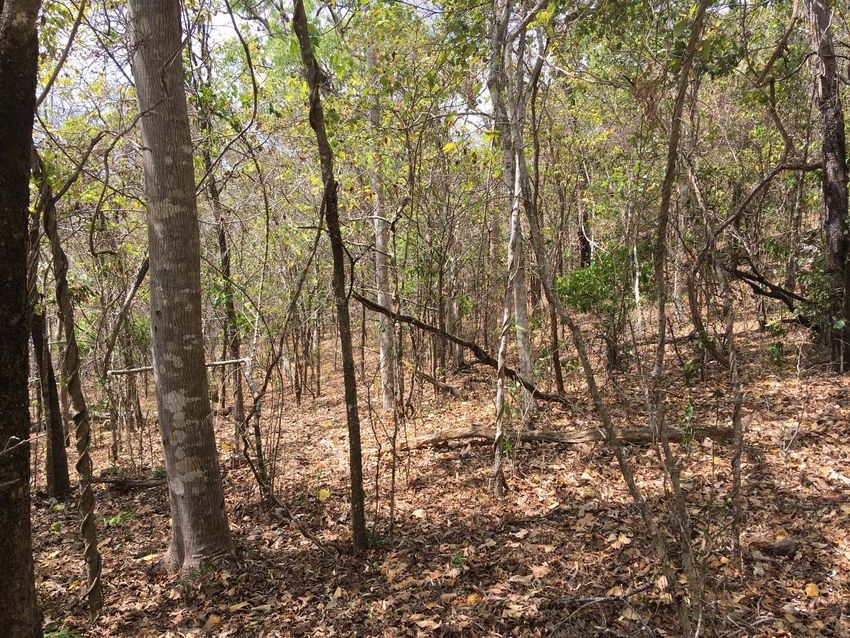
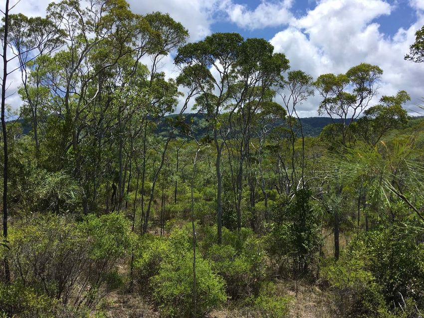
A.1 Woodland
Medium to tall open canopy forest with a canopy dominated by sclerophyll species and a ground
layer dominated by grass and sedge. Generally in areas of more seasonal rainfall, low fertility or
frequently burnt by fire. In areas close to rainforest, woodland can have varying degrees of
rainforest in the understory from very scattered pioneer species to a well developed rainforest
understory where fire is completely excluded. In the latter case the boundary between woodland
and rainforest habitat types is arbitrary.
Common tree species include: Corymbia clarksoniana (Clarksons bloodwood), C. tesselaris
(Carbeen), Eucalyptus crebra (Narrow leafed ironbark), E. tetradonta (Darwin stringybark),
Lophostemon suaveolens (Swamp Box), Melaleuca viridiflora (Broad leafed tea‐tree) and M.
stenostachya (Fibre barked tea‐tree).
Regional Ecosystems (Queensland Government 2007) that are well represented on the McIlwraith
Range: 3.3.8/22/31/42, 3.11.8/15, 3.12.7/8/9/10/18/42/45
Figure A.1. An example of woodland habitat.
Bradford et al. Cape York cassowaries | 19A.2 Vine thicket Low to medium closed canopy forest with deciduous to semi‐deciduous species in the canopy and subcanopy. Generally occurs on metamorphic or igneous substrate in areas with more seasonal rainfall. Can contain woodland species in the canopy as a result of rainforest invasion over the last 100 years or due to opportunistic establishment under the seasonally absent canopy. Common species include: Acacia spp., Aluerites moluccana (Candlenut), Buchanania arborescens (Green plum), Canarium australianum (Island white beech), Euroschinus falcata (Cudgerie), Dinosperma erythrococcum (Tingletongue), Pleiogynum timorense (Burdekin Plum), Psydrax odorata (Shiny‐leafed canthium), Ziziphus oenopolia (Wine jujube). Equivalent Regional Ecosystems (Queensland Government 2007): 3.11.21, 3.12.21abx1 Figure A.2. An example of vine thicket habitat. A.3 Gallery rainforest Tall closed canopy evergreen to semi‐deciduous forest on alluvial soil along rivers and larger creeks and some swamps. Forests on alluvial plains adjoining slow moving rivers and creeks can be extensive. Areas on rivers and creeks flowing through more seasonal country are generally confined to a thin strip (10‐30 m) on either side of the watercourse becoming more extensive on the inside of bends. Soils are generally deep, sandy to loamy and nutrient rich. These forests flood seasonally. Gallery forest can occur in association with moist rainforest, vine thicket, woodland and occasionally wet rainforest. Common tree species include: Castanospermum australe (Black bean), Beilschmiedia obtusifolia (Blush walnut), Buchanania arborescens (Green plum), Ficus nodosa (Cape fig), Ficus albipila (Abby 20 | Bradford et al. Cape York cassowaries
tree), Nauclea orientalis (Leichardt tree), Syzygium bamagense (Bamaga satinash), (Syzygium
pseudofastigatum (Claudie satinash) and Tetrameles nudiflora (Kajoolaboo).
Equivalent Regional Ecosystems (Queensland Government 2007): 3.3.1ax1, 3.3.4, 3.3.5a, 3.3.6

Figure A.3. An example of gallery rainforest habitat.

A.4        Moist rainforest
Medium to tall closed canopy evergreen to semi‐deciduous forest of high rainfall but more
seasonal areas. Generally occurs below 400 m asl although can occur to higher altitudes along
ridges and where the rainfall is more seasonal. May have Aurucaria cunninghamii (Hoop pine) as
an emergent. Often has Acacia spp. on exposed ridges. Can occur in areas mixed with wet forest
depending on slope position and aspect. Includes rainforest occurring on sand. Often contains
woodland species in the canopy as a result of rainforest invasion over the last 100 years.
Common tree species include: Acacia polystachya (a wattle), Aleurites moluccana (Candlenut),
Argyrodendron polyandrum (Brown tulip oak), Beilschmiedia obtusifolia (Blush walnut),
Blepherocarya involugrigula (Rose butternut), Cryptocarya hypospodia (White sycamore) and
Elaeocarpus arnhemicus (Blue plum).
Equivalent Regional Ecosystems (Queensland Government 2007): 3.11.1x1, 3.11.3, 3.12.2,
3.12.3bc, 3.2.11

                                                                     Bradford et al. Cape York cassowaries | 21
Figure A.4. An example of moist rainforest habitat. A.5 Wet rainforest Medium to tall closed canopy evergreen forest of high rainfall, less seasonal areas. Generally occurs above 400 m asl although can occur to lower altitudes along drainage lines. May have Aurucaria cunninghamii (Hoop pine) as an emergent. Often has Acacia spp. thickets on exposed ridges. Can occur in areas mixed with moist forest depending on slope position and aspect. Common tree species include: Acacia midgleyi (Cape York salwood), Alstonia scholaris (Milky pine), Calophyllum australianum (Blush touriga), Cryptocarya vulgaris (Northern laural), Garcinia warrenii (Native mangosteen), Podocarpus grayae (Brown pine), Syzygium hemilamprum (Cassowary gum) and Xanthostemon chrysanthes (Golden penda), Equivalent Regional Ecosystem (Queensland Government 2007): 3.12.3a 22 | Bradford et al. Cape York cassowaries
Figure A.5. An example of wet rainforest habitat.

                                                    Bradford et al. Cape York cassowaries | 23
References
Bradford, M. G., A. J. Dennis, and D. A. Westcott. 2008. Diet and dietary preferences of the Southern
Cassowary (Casuarius casuarius) in North Queensland, Australia. Biotropica 40:338‐343.
Centre for Australian National Biodiversity Research. 2018. Australian Tropical Rainforest Plants Edition 7
[online version]. Pages http://www.anbg.gov.au/cpbr/cd‐keys/rfk/.
Department of Environment and Resource Management. 2009. Distribution of cassowary habitat in the
Wet Tropics bioregion, Queensland (3rd Edition). DERM, Queensland.
Latch, P. 2007. National recovery plan for the southern cassowary Casuarius casuarius johnsonii. Report to
the Department of Environment, Water, Heritage and the Arts., Canberra.
Makinson, R. O. 2018. Myrtle rust reviewed: the impacts of the invasive pathogen Austropuccinia psidii on
the Australian environment. Plant Biosecurity Cooperative Research Centre, Canberra.
McLean, W. R., R. L. Goldingay, and D. A. Westcott. 2017. Visual lures increase camera‐trap detection of the
southern cassowary (Casuarius casuarius johnsonii). Wildlife Research 44:230‐237.
Queensland Government. 2017. https://environment.ehp.qld.gov.au/regional‐ecosystems/.
Westcott, D. A., S. Metcalfe, D. Jones, M. Bradford, A. Mckeown, and A. Ford. 2014. Estimation of the
population size and distribution of the southern cassowary, Casuarius casuarius, in the Wet Tropics
Region of Australia. Cairns.
CONTACT US FOR FURTHER INFORMATION
t 1300 363 400 Insert Business Unit name
+61 3 9545 2176 Insert contact name
e csiroenquiries@csiro.au t +61 0 0000 0000
w www.csiro.au e first.last@csiro.au
w www.csiro.au/businessunit
AT CSIRO, WE DO THE Insert Business Unit name
EXTRAORDINARY EVERY DAY Insert contact name
We innovate for tomorrow and help t +61 0 0000 0000
improve today – for our customers, all e first.last@csiro.au
Australians and the world. w www.csiro.au/businessunit
Our innovations contribute billions of
dollars to the Australian economy Insert Business Unit name
every year. As the largest patent holder Insert contact name
in the nation, our vast wealth of t +61 0 0000 0000
intellectual property has led to more e first.last@csiro.au
than 150 spin‐off companies. w www.csiro.au/businessunit
With more than 5,000 experts and a
burning desire to get things done, we are
Australia’s catalyst for innovation.
CSIRO. WE IMAGINE. WE COLLABORATE.
WE INNOVATE.
24 | Bradford et al. Cape York cassowariesYou can also read