Challenges and Opportunities for Autonomous Vehicle Query Systems
←
→
Page content transcription
If your browser does not render page correctly, please read the page content below
Challenges and Opportunities for Autonomous Vehicle
                        Query Systems

                           Fiodar Kazhamiaka∗, Matei Zaharia, and Peter Bailis
                                                           Stanford University

ABSTRACT
Autonomous vehicles (AVs) collect and process rich visual
and dimensional data as they operate. Across a fleet of AVs,
the collective data forms an up-to-date partial snapshot of
the physical world. The ability to query this data has many
use-cases, from finding open parking spots and checking the
line outside a coffee shop, to monitoring the usage of urban
spaces and road conditions. Managing AV data has unique
challenges with respect to data volume, bias, and privacy
issues. In this paper, we take steps to describe the design and
research opportunities for a new class of data management
systems: AV query systems.                                                    Figure 1: AV camera image with vehicle bounding-boxes [40]

1      Introduction
                                                                             space is used, or what kind of vehicles are using a particular
Several generations of sensing devices – from smartphones                    road segment over the past year; delivery truck drivers want
to UAVs and inexpensive satellites – have unlocked new op-                   to know about open parking spots closest to their destination;
portunities for querying the world with data. Smartphones                    investors look for creative “alternative data” queries to gain
revolutionized the mobile sensing landscape with their ubiq-                 insight into investment opportunities.
uity, array of sensors, and processing power. However, despite                  We believe that autonomous vehicles (AVs), with their
their pervasiveness, smartphone sensor data provides limited                 array of visual and laser sensors, powerful onboard computing
insight into the state of the surrounding world. Camera and                  hardware, and mobile coverage, will bring about the next
microphone sensors, which could theoretically be leveraged                   revolution in both the quantity and quality of data obtained
to provide observations of the local environment, are kept off               on the outside world by leveraging their hardware to form
per the user’s expectation of privacy. Instead, visual sensor                a mobile sensory and computing network. This is made
networks in the form of static camera networks, satellites,                  possible by the ongoing proliferation of sweep sensors on
and camera-mounted drones are deployed to let users query                    cars, and by advances in computer vision algorithms for
a wide variety of physical phenomena, such as monitoring                     physical object detection through video and other sensors;
traffic [6] and store parking lots [39], streaming wave cameras              crucially, these algorithms are already deployed as part of
for surfing [15], and detecting events such as oil spills [14].              the car’s driving task.
   However, there are many more examples of useful queries                      Contemporary cars with self-driving systems, such as
about the physical world that cannot be answered by existing                 Tesla’s Autopilot [16] and Cadillac’s Super Cruise [8], cap-
approaches. This is especially true for queries requiring high-              ture high-resolution visual and structural data of the world
resolution sensing, wide coverage, and real-time response.                   they navigate. This data is processed to mark location, class,
A commuter might want to know how many people are                            and velocity of objects such as pedestrians and vehicles, as
currently in line at every coffee shop on their way to the                   in Figure 1. Consider the data collected and processed by
office; road-way patrols want to monitor road conditions in                  a fleet of several hundred vehicles driving through a city;
real-time; a city planner could ask how a particular public                  at any moment in time, the combined data forms a par-
∗
    Correponding Author: fiodar@stanford.edu                                 tial present-state snapshot of that city. This data can be
                                                                             processed on-board, and/or transferred to one of a network
                                                                             of local data warehouses that answer queries, as shown in
                                                                             Figure 2. In its most ambitious form, data will be collected
                                                                             across millions of cars from around the world, providing
                                                                             unprecedented coverage and detail of physical space.
This article is published under a Creative Commons Attribution License          In this paper, we argue that realizing the opportunity for
(http://creativecommons.org/licenses/by/3.0/), which permits distribution    large-scale analysis and storage of AV fleet data will require
and reproduction in any medium as well allowing derivative works, pro-       a new class of data management systems: AV query sys-
vided that you attribute the original work to the author(s) and CIDR 2021.
11th Annual Conference on Innovative Data Systems Research (CIDR ‘21)        tems. AV query systems must tackle several challenges that
January 10-13, 2021, Chaminade, USA.                                         differentiate them from existing data management systems: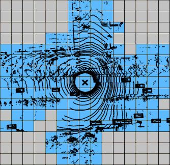
Data volume. AV sensors generate terabytes of data per                                       Geo-distributed                 Nation/State-scale
                                                                    Users                    queries                         Cloud Database
hour. A fleet of AVs generates several orders of magnitude
more data than any existing widely-deployed sensor network.                                   Results
This volume is both a blessing and a curse. The data pro-
vides a detailed view of the physical world surrounding the                    Localized   Results                   Data    Intermediate
                                                                                queries                           requests   results
AV; however, it is impractical to upload and store in en-
tirety across a large fleet of AVs. Classic techniques such         City-scale                                                              Storage
as sampling every nth frame and inter-frame compression             Cloud Servers &
                                                                    Data Warehouses                                                     Processors
algorithms are insufficient, and the vast majority of sensor
data will have to be discarded. This leads to several research
questions: How should the system balance data storage and                                    Data              Data
                                                                                           upload              requests
transmission costs with the querying power that is lost when                 Cameras
data is discarded? How can the system be designed to sup-           AVs                                                              Processors
                                                                                LIDAR
port different query modes, for example, real-time queries,               Localization                                               Storage
historical queries, and queries on arbitrary data?                                                                                   Neural
                                                                                                                                     Accelerators
Sampling bias. Unlike most sweep-sensor networks, AVs
are mobile, and the collected data is tied to when and where                       Figure 2: AV query system architecture
their passengers need to travel. This results in a sampling
bias that affects queries on statistics related to transient
events, for example, a query to identify the road segment           removal. Existing sensor systems, such as camera networks
with the heaviest bike traffic within a city. How can AV data       and satellites, are unable to monitor the road with enough
be de-biased to provide accurate query answers?                     coverage and detail to detect debris.
Privacy. The data collected across a fleet of AVs can ex-           Q3: What percentage of the time between 8 am and
pose both AV owners and observed individuals to privacy             8 pm is there a cyclist on the road near a particular
intrusions. If not handled carefully, the data may be used          intersection over the past year? This query could be
for invasive purposes such as tracking individuals. How can         asked by urban planners who are looking for data on urban
AV data be made queryable while preserving the privacy of           space usage and traffic calming measures – in this case tar-
the car owner and observed persons?                                 geting streets with high cyclist traffic for a new development
  In the rest of the paper, we describe our vision for AV query     of cyclist-friendly lanes. This query requires observations
systems, discuss several emergent technical research problems,      made of the target intersection over the past year. Existing
and introduce a proposed system architecture (Figure 2). We         approaches to answering such queries involve physically mon-
present empirical evidence from existing AV datasets, propose       itoring the road, or setting up cameras to monitor specific
initial directions for several of these problems, and discuss       parts of the road, which is tedious and delays the collection
design trade-offs meriting further investigation by the data        of statistics.
management community.
                                                                    Q4: How many people are currently in line at a
2    Motivating Queries                                             store’s locations? This query may be asked by the general
Queries about the physical world are typically spatio-temporal,     public to check on wait-times, or by stock traders as a proxy
meaning that a target geographical location and time are            for estimating sales before they occur. The query could
specified or are part of the result. The queried subject is         be formally specified by first identifying the areas in which
an object such as a vehicle, a geographical location, a time        people might line up around every store that is visible from a
range, or a set of these. Below, we list four examples of           road (e.g., Tartine bakery in San Francisco), and counting the
queries that an AV query system could answer.                       number of stationary people observed within; more complex
                                                                    execution strategies can cross-correlate lines observed across
Q1: Where are the 3 closest currently-open parking
                                                                    similar stores. While smartphone location data could be used
spots to a particular location? This query can come
                                                                    to estimate this query, many people keep location tracking
from anybody looking to park their car, and is especially use-
                                                                    off by default on their personal device.
ful as a tool for ”last-mile” logistics, where parking a delivery
vehicle is a major hindrance to efficient delivery [2]. Camera         In summary, AV query systems have the promise to an-
networks and satellites cannot answer this query for arbitrary      swer these queries using data that is collected and processed
locations; both systems are limited by their coverage, and          as a byproduct of AV driving, which allows results to be
satellite imagery is not updated frequently enough to provide       obtained efficiently and at scale compared to existing ap-
useful results. AV data can identify locations where cars are       proaches. Other queries may require additional processing,
often parked, and the recent observations of each spot reveal       for example classifying a vehicle’s make and model to es-
their availability. Alternatively, if the query is performed        timate demographics [30]. In such cases, the accuracy of
ad-hoc (e.g., by an app that finds parking for its users) it        downstream classification models can be improved by us-
can be executed by directly querying the status of known            ing data from multiple sensors, such as camera and LIDAR
parking spots.                                                      [42]. The key challenges lie in the efficient, accurate, and
                                                                    privacy-preserving execution of these AV queries.
Q2: Which locations currently contain debris on the
road? This query is useful for roadway patrols, who cur-            3     Challenge: Data Volume
rently rely on drivers that can safely phone in to report
debris [3]. AVs can detect debris and upload its location and       Data volume represents a major challenge in AV query sys-
image, and a stream query allows for prompt response and            tems. Each AV is expected to generate 3-6 TB of raw data
Table 1: Pedestrian and Vehicle Observations in AV Data
per hour of operation1 depending on the sensors installed.
We focus primarily on visual data in the form of video frames Dataset (Camera FPS) NuScenes (2) Lyft (5)
collected by upwards of six high-resolution (2K) and high- Location Singapore Boston Palo Alto
frequency (at least 30fps) cameras, and comprises the major- Images Analyzed 92,184 112,710 136,080
ity of this volume. In this section, we discuss the problem of Instance Annotations 261,756 623,264 637,993
managing this data, the implications on the queries that can Avg. Instances/Image 2.84 5.53 4.69
be supported by the system, and how data volume can be Unique Instances 14,567 32,791 17,190
reduced. Avg. Unique Instances 1.89/sec. 3.49/sec. 3.82/sec.
3.1 Keeping the Data in Entirety is Impractical Sampled images, Alg 1 5,432 9,754 12,052
Consider an AV that drives an hour a day generating data
at a rate of 5 TB/hour, and assume that the data is down- Expressivity: Pre-specified versus Ad-hoc. The sys-
sampled from 30 Hz to 2 Hz and compressed by a factor tem can mandate that queries must be submitted before any
of 10×, down to 33 GB/hour. Uploading this volume of relevant data is collected. To support pre-specified queries,
data is impractical across a fleet of vehicles; 5G networks only the data required by each query needs to be collected.
are expected to support up to 10 Gbps (4.5 TB/hour) rates Any real-time query is inherently pre-specified, while queries
in ideal conditions, but in practice, speeds are much lower on past observations, such as Q3, would have to be specified
[41]. Even if transmission bandwidth is not a concern, the “over the next year” and then wait while data is gathered.
cost of uploading data at $0.05/GB [5] is $12.50/hour, and Ad-hoc queries, including those on past observations, are the
storing an hour of data in Amazon Glacier at $0.004/GB per most challenging to support. They require the collection of
month [7] costs $1.6 over a year. The resulting yearly data all data that might be touched by a query, which is impracti-
volume is 12 TB, which costs $1200 to upload and store for cal given the volume of AV data and the diversity of possible
a year, and presents a significant cost burden when scaled queries. A best-effort approach is needed to filter out data
to hundreds of thousands of vehicles. This problem requires that is less likely to be useful. In particular, data featuring
algorithms that reduce the raw data volume by an order of dynamic objects, such as pedestrians, vehicles, and animals
104 ×, which will impact both the cost and querying power could be collected more often than data featuring objects
of the system. whose state changes very slowly, such as building facades.
There are many approaches to reducing data volume. In
the following, we discuss how data can be reduced to support 3.3 Content-Driven Data Selection
specific AV query modes, content-driven data selection, and Several promising approaches for reducing data volume are
efficient data formats. summarized by the following two principles: 1) Additional
observations of an object add a diminishing amount of new
3.2 Query Modes
information, 2) An object’s state can often be represented in
Ideally, only the data that will be used to answer queries a low-volume data format.
should be stored; this context-aware data reduction would Intuitively, static objects will not change much across con-
minimize transmission and storage costs without sacrificing secutive observations, and additional image frames are often
querying power. To explore this idea further, we discuss redundant and may be discarded without loss of informa-
different query modes that can be supported by the system: tion. For example, a parked car may require only a single
real-time, historical, pre-specified, and arbitrary queries, and image along with a set of annotations marking every time
their implications on data volume. that particular car is observed to be in the same parking
spot. For dynamic objects such as pedestrians, a passing AV
Query scope: Historical versus Real-Time. Queries
collects and processes video and LIDAR data to estimate
can pertain to present (real-time) or past (historical) states
their velocity and location. The velocity and location of the
of the physical world. For real-time queries, only the required
pedestrian can be described using several bytes of data, and
data needs to be uploaded. Data can be discarded after
captures much of their state without requiring the entire
the query result is obtained to avoid the accumulation of
video clip encoded in millions of bytes. Ideally, the image
storage costs over time. Queries on the present state often
corresponding to each object is chosen in a way that sup-
require low latency, implying that AVs must upload their
ports further object classification. After reduction, the visual
observations in real-time over a potentially expensive channel.
data uploaded by an AV over the course of a trip no longer
The latency of a real-time query is most affected by how
resembles a smooth video stream, but rather an album of
long it takes for AVs to pass by the target locations, and
images featuring observed dynamic objects.
on processing time; contemporary computer vision models
process an image in tens of milliseconds on a server-side 3.3.1 Empirical Study of AV Data Content
GPU [17] and sub-second on mobile phone-level hardware
To better understand the information density of AV data, we
[37]. Historical queries require data to be collected and stored.
analyze the dynamic objects observed in real driving scenes
The relevant data be uploaded opportunistically, for example
from the NuScenes [24] and Lyft Perception [40] datasets,
over WiFi + fiber rather than a cellular data connection.
which sample AV sensors at 2 Hz and 5 Hz, respectively. We
However, AV on-board storage is limited, and data should
focus on the visual data samples, which are composed of
be off-loaded when possible to avoid being over-written.
6 images coming from 6 cameras that provide 360◦ visual
1
For example, consider a 30 fps 2K video camera, where each coverage. The data is organized in 1080 separate 20-25
frame consists of 2048×1080 pixels across 3 channels with second-long scenes located in Boston, MA, Palo Alto, CA,
16-bit precision, for a total of 12.65 MB per frame, or ≈ 1.3 and Singapore, and is indicative of city driving scenarios.
TB/h per camera. Each sample is annotated with the location of objects such1.0
Cumulative Fraction of Samples Singapore
Algorithm 1: MIN-FRAME
median:14 Result: Set of points S that covers all intervals
0.8 Palo Alto
median: 29 N intervals [xi ,yi ], sorted by finish time y
0.6 Boston S, M ← {}
median:30
for i ← 1 to N do
0.4
if i 6∈ M then
0.2 S ← S ∪ yi
M ← M ∪{j : xj ≤ yi }
0.0 end
0 20 40 60 80 100 120
Vehicles and Pedestrians Observed per Sample end
Figure 3: Distribution of observed vehicles and pedestrians.
XN: object N with a 10:1 intra-frame compression ratio, the volume is re-
`marked’ frames enters view duced by 670-2570× to 1.9-7.5 GB/h, or $69-$274 in storage
YN: object N
and transmission costs per year for the example given in
leaves view Section 3.1.
However, this approach is a simplification of the setting.
…
In reality, the quality of a sample with respect to an object
object 4
object 3
changes over its interval of observation. For example, a
object 2
object 1 sample that captures several objects at a short distance
without any obstructions is more useful for downstream
Time
processing than a sample where those same objects are distant
Figure 4: Visualizing objects entering and leaving an AV’s and/or obstructed. Balancing sample quality with sample
view. Dashed lines represent frames chosen by the min-frame volume is an interesting optimization problem that warrants
algorithm. further study.
Scenarios where multiple AVs simultaneously observe the
same object can lead to redundancies in the union of their
as pedestrians, vehicles, and various driving-related obstacles collected data. If the data is being uploaded to a cen-
and signage, and object instances are tracked across samples. tral database, then redundant transmissions can be avoided
Table 1 shows the observation statistics for dynamic ob- through a simple protocol that, before sending expensive
jects, specifically pedestrians and vehicles. Each image con- image frames, checks for existing observations with matching
tains an average of 4-5 objects, and the rate of objects that features and location. We are not aware of existing datasets
come into view is roughly 2-4 per second. If a single unique featuring this scenario, and are currently developing one us-
image for each observed pedestrian and vehicle is kept, then ing Carla [28], an AV driving simulator. This effort is similar
the total reduction in data volume, assuming 6 cameras in spirit to the Visual Road benchmark [32] for static camera
recording at 30 fps, is between 47-95× before any inter-frame data that is built using the same simulator.
image compression is applied.
3.4 Efficient Data Formats
The distribution of dynamic object density across all sam-
ples is shown in Figure 3; at least 50% of samples have 14 Selective image compression can be used to reduce the size
or more instance observations across 6 cameras, the exact of image segments that hold less information [10, 20]. For
number varying with location. Capturing multiple objects example, the image in Figure 1 can be compressed with
within a single sample can reduce the number of samples lossy algorithms in sections outside of object bounding boxes,
needed to capture all objects. such as the road surface, trees, and sky. However, high-
resolution images are important for object detection and
3.3.2 Algorithms for Frame Selection
classification accuracy [57], and backgrounds can provide
It is helpful to first consider a simpler form of the problem. important context for some queries (eg. on the presence of
Sample selection can be framed as an interval coverage prob- dangerous black ice on road surfaces.) Hence, it’s preferable
lem: given a set of one-dimensional intervals, representing to explore data formats where these features are preserved.
the times at which object enters and leaves an AV’s view, Embedding networks provide opportunities to extract fea-
we seek a minimal set of points (samples) that covers all tures from high-resolution data, and offer an alternative,
intervals. Figure 4 visualizes this in one dimension. A mini- lower-volume data representation. An embedding network
mal set can be obtained using Algorithm 1, where intervals can be used to convert an image into a condensed set of
are ‘marked’ whenever a point in the interval is added to image features, which can be processed during query time
the set; points are considered in ascending order, and are by a model trained on those features. The challenge in this
added when a hitherto unmarked interval ends. The proof approach lies in creating an embedding that captures the
of optimality for this algorithm is provided in the appendix. large state space of AV data. Recent work in this space in-
The last row of Table 1 records the number of images cludes spatio-temporal scene tagging [51] using a “universal”
needed to capture all unique vehicle and pedestrian instances embedding network trained alongside a large set of attribute
in each dataset using the min-frame algorithm. The sam- embeddings. This work presumes an exhaustive list of scene
pling rate, compared to an initial rate of 180 images per attributes that might be queried. Extending universal em-
second (30fps, 6 cameras) drops to 0.7 for Singapore, 1 for beddings with additional attributes that weren’t initially
Boston, and 2.7 for Palo Alto, a 67-257× reduction. Coupled considered in order to support queries on ad-hoc attributesis an interesting research direction.
4.0
3.5 Summary of Data Volume Challenge
3.5
In summary, AVs produce data in volumes that can’t be 3.0
stored or transmitted at scale. and we discussed three ways
2.5
in which this data can be reduced while minimizing infor-
mation loss. First, data can be filtered to match specific 2.0
classes of queries, especially when queries are assumed to 1.5
be pre-specified. Second, interesting objects and events are 1.0
not evenly distributed across frames, and algorithms for bal- 0.5
ancing frame quality and data volume are needed. Third,
0.0
alternative formats, such as embeddings, could store image
features rather than pixels, and the creation of a universal (a) Town rendering (b) Bike location (%)
and extensible embedding to capture the large AV data state
space is a promising direction. 2.5 0.200
0.175
4 Challenge: Data Bias 2.0
0.150
AVs collect data opportunistically as a byproduct of their 0.125
1.5
transportation task. Due to the spatial and temporal pat- 0.100
terns that naturally occur in traffic, the data has both spatial 1.0
0.075
and temporal bias. This bias is a problem for queries about
stochastic phenomena. For example, consider Q3 from Sec- 0.5
0.050
tion 2 on the frequency of observing cyclists in a particular 0.025
intersection during the daytime. AVs are more likely to drive 0.0 0.000
through the intersection during commuting hours, which may
be correlated with the presence of cyclists. Naively averaging (c) AV location observations (%) (d) AV bike observations (%)
the number of cyclists seen across the collected frames would Figure 5: Carla simulation with one AV and 17 bikes over 48
give an incorrect result when the frames are saved only if hours. 5b shows the percentage of time a bike is within each
they contain something of interest. 5×5m cell, 5c shows the percentage of time each location
In this section, we discuss how to account for biased data is observed by an AV, and 5d shows how often a bike is
using importance sampling, how to estimate the sampling dis- observed by an AV.
tribution, and the caveats of applying importance sampling
to AV data.
saved camera frame. The results grossly overestimated the
4.1 Importance Sampling presence of bicycles in the majority of locations. This is
Importance sampling is a general technique for estimating the expected, as the sampling distribution reflects observations
properties of a distribution (eg. bicycles in the intersection) only in the presence of dynamic objects, which naturally
using samples generated from a different distribution (eg. skews the query result to over-estimating the likelihood of
AV traffic patterns). At a high level, importance sampling is object presence.
the use of the sampling distribution to adjust an observed 4.2 Estimating the Sampling Distribution
statistic. For example, to execute Q3, the number of bikes
observed in a particular location should be normalized by To serve arbitrary location queries, each AV must upload
the frequency with which the location was observed. As both an observation record describing the time and location of
observations and bike frequency depend on the time of day, all observations. We propose a segmentation abstraction
adjustment should be done over short time intervals and then for tracking observations, where location is discretized for
aggregated to produce the final result. However, importance tractability. Observed segments are identified through GPS,
sampling requires knowledge of the sampling distribution; LIDAR, and supporting localization sensors. Figure 7 il-
for Q3, this equates to tracking AV observations of the lustrates this concept in 2D; a LIDAR sweep, shown as a
intersection. Restated, it is not enough to track only bike point cloud, is superimposed onto a color-coded grid that
observations; all observations of intersection must be known. segments the physical world and indicates which locations
This is problematic for data from mobile sweep sensors in are observed. Using a 3D discretization allows for physical
an environment with many line-of-sight obstacles and where locations to be queryable in three dimensions, although many
the vast majority of data is discarded. use-cases can be satisfied with 2D. Each segment corresponds
To demonstrate the error of an incorrect sampling distri- to an observation record consisting of three items: an ID
bution in a realistic setting, we ran an experiment in Carla that uniquely identifies the segment, and two timestamps
where an AV drives around a small town and tracks dynamic marking when the segment was in view. Returning to Q3,
objects (cars, bicycles, and pedestrians) encountered within a the sampling distribution is characterized by the records of
20-meter radius over 48 hours. The AV keeps video frames if segments composing the target intersection.
they contained a dynamic object. Some of the data generated This approach is not perfect, as segments may be observed
from this experiment is summarized in Figure 5. We then without LIDAR detecting them. For example, many concrete
queried every 5×5-meter cell containing a roadway, scaling freeway dividers block sight of the roadway, but vehicles are
the frequency of bike observations (Figure 5d) by the inverse still visible. In this case, the sampling distribution of the road
of the frequency with which each location is captured in a is skewed to observations involving vehicles. Furthermore,cumulative fraction 1.0 cars, cyclists, and pedestrians that join it at the intersection,
and that would otherwise have been missed if the traffic light
0.8 was green. It then continues to drive among the group of
vehicles that built up while the light was red, resulting in
0.6
objects being present in the data with a higher frequency
0.4 than they occur. We have observed the relationship between
using naive sampling dist., sampling and object presence to be common in our initial
μerr = 1.91
0.2 experiments in Carla. When we use importance sampling
using sampling dist. based on
car location, μerr = 1.29 with the better sampling distribution obtained using the
0.0
technique described earlier, the errors are lower but still
−5.0 −2.5 0.0 2.5 5.0 7.5 10.0 12.5 15.0 heavily skew towards over-estimating Q3 (Figure 6. This can
error be partially attributed to the synchronization of AV and bike
traffic. How to adjust for this behavior is an open question.
Figure 6: Distribution of the magnitude of error in estimating
the percentage of time each road segment contains a bike. 4.4 Summary of Bias Challenges
Using an accurate sampling distribution reduces the error, In summary, we discuss two challenges to dealing with AV
although it does not fully eliminate it. data bias. First, tracking observed locations to estimate the
sampling distribution allows us to use importance sampling,
with opportunities to reduce the overhead in managing this
data over large areas and at high resolution. Second, the
distributions of samples and of observed phenomenon may
not be independent and can skew query results.
5 Challenge: Privacy
Privacy is of primary importance for AV query systems. AV
data can be used to infringe on personal privacy rights of
the observed as well as the observers (AV owners). Most
people experience “overwhelming discomfort” at the idea AV
(a) 15m × 15m segments (b) 5m × 5m segments data being used to identify and track individuals [22]; on
Figure 7: Aerial view of a LIDAR point cloud, from [40]. ”X” the other hand, most reported feeling comfortable sharing
marks the location of the LIDAR sensor, and rectangles mark anonymized data collected by their car [26] [46], especially if
the location of observed vehicles. Smaller segments offer higher benefiting from the features it enables. We discuss privacy
specificity of which areas are observed (blue), providing a more implications using Google’s StreetView as a case study, and
accurate sampling distribution estimate for each location. how privacy concerns may differ depending on the use-case.
5.1 StreetView Case-Study
the right granularity of the segmentation is not obvious
and presents a trade-off between query accuracy and data StreetView, which launched in 2007, challenged pre-existing
management. Smaller segments allow the system to query notions of privacy. A prevalent concern is public access to
very specific locations at the cost of having to manage many photos of individuals who may be engaging in activities that
records, while large segments lose specificity but reduce the they would not wish to be published online [49]. As a result,
overhead of managing records. For example, in a city the some countries are sparsely covered by StreetView outside of
size of San Francisco (120 km2 ) with 25% visibility from a major cities [4], while others prohibit it entirely over security
roadway, a 5m×5m segmentation as in Figure 7b creates 144 concerns [1].
million segments. Segment sizes do not need to be identical AV query systems exacerbate the issues faced by StreetView.
across all physical locations; there may be a greater benefit to For example, StreetView blurs faces and license plates in
smaller segments in information-dense urban landscapes, and their images to preserve privacy. In an AV query system,
larger ones along rural roads and expressways. A technique there may be multiple images of an individual over time. It
for context-aware segmentation that considers both overhead takes as little as four spatiotemporal data-points to distin-
and sampling estimation error is needed here. guish a particular individual from over a million others with
high accuracy [27]; blurring the face or license plate does
4.3 Where Importance Sampling Can Fail little to preserve the privacy of the individual, who could
In AV data, there is no guarantee that observed phenomena be tracked across multiple observations by their clothing or
are independent of the sampling distribution. Consider an other features. Advanced forms of data redaction, such as
AV that is always chased by a dog as it drives by a particular silhouette redaction via image segmentation [45], are needed.
house; the data would suggest that a dog can always be The owner of an AV that uploads data is also suscepti-
found on the stretch of road near the house, though in ble to privacy violations. While this could be solved by
reality this occurs only in the presence of AVs. Covariance removing any associations of the observing AV from their
between sampling distribution and observations can skew data, it poses a problem for systems which compensate AVs
query results. in proportion to the value realized through their data. In
The example with the dog is not as pathological as one this case, the problem could be ameliorated by periodically
might expect. A moderate form of this phenomenon occurs refreshing an AV’s identifying tag, as done in contact tracing
through traffic lights, which synchronize traffic patterns. The apps [25]. However, images can sometimes be attributed to
longer an AV is stopped, the more likely it is to observe other a specific camera by analyzing digital camera noise “finger-prints” [29]. Approaches to mitigate these issues, for example limit data movement, and partially process wide-scale loca-
by introducing obfuscating noise, need to be explored. tion queries that are submitted to by higher-level servers.
Figure 2 shows a hierarchy with two levels, city-scale servers
5.2 Privacy by Use-Case
and nation/state-scale servers; additional levels can be added
Different use-cases of AV-query systems have varied notions to support wider-scale queries.
of privacy. In some cases, a car owner may wish to opt
Active data collection. AV’s could collect data for answer-
into sharing sensitive data. For example, consider a child
ing queries passively, as a byproduct of driving. However,
abduction alert that is broadcast to every AV with informa-
AV’s could be encouraged to drive past locations featured
tion on the make, model, and license plate number of the
in existing un-served queries, or which haven’t had recent
suspected kidnapper’s vehicle. The user could be prompted
observations uploaded. Query-aware navigation has a place
to temporarily allow for the detection of the specific car,
in a framework that compensates AV owners proportionally
and flag its location to the police. This capability would
for data that is used to answer queries.
require judicious use and oversight, and should be designed
to minimize privacy invasions. For example, rather turning 6.2 Design Trade-Offs
off redaction for all image uploads, the car could download Selecting the optimal design for each query mode requires a
and run a light-weight model designed to detect the target cost model that considers many factors in addition to what we
vehicle. discussed in Section 6.1 that are presently unknown, such as
query workload, availability of AV on-board processing, and
6 Implications for System Design query service monetization. Here, we sketch three potential
To illustrate the design space for an AV query system, we AV query system designs, each supporting a different set of
present a system architecture for physical components and query modes.
data flow in Figure 2. Users represent individuals send- A: Pre-specified + real-time query design
ing queries through a web portal, or applications that send
Queries are broadcast to AVs in the region of interest. The
queries to the servers through an API. AVs and cloud servers
server specifies the required data, and provides the com-
are entities within the system that are equipped with com-
puter vision models for processing the data at the edge. For
puting hardware and storage, and data flows between them.
real-time queries, the data is uploaded to a regional server
Submitted queries are answered using data from AV sensor,
for timely processing, while other queries are processed op-
including cameras, LIDAR, RADAR, and sensors that help
portunistically at the edge and partial results are uploaded
with localization. AVs can be made aware of queries, and
to the server for aggregation. AV owners are compensated
send their observations to a data warehouse.
by clients in proportion to their contribution to the query
The choice of query modes has many implications on sys- result, and the AV navigation system takes into account the
tem design. Real-time queries require timely data uploads expected revenue from various travel routes. This design es-
and processing, and historical queries require vast amounts pecially favors electric AVs that spend a long time connected
of storage. Supporting only pre-specified queries minimizes to a power source. In this design, AVs comprise a virtual
data volume, while supporting arbitrary queries on historical distributed computing and sensing platform for answering
data requires vast amounts of data. In this section, we cover real-time queries.
system design variables that are mostly unaffected by query
mode, and propose three designs that navigate the design B: Arbitrary historical query design
space while supporting different query modes. Data is opportunistically uploaded to a regional warehouse,
where it is used to answer historical queries. Some basic
6.1 Design space processing such as redaction and volume reduction happens
Here, we discuss the design space with respect to where at the edge. The AV is made aware of pre-specified queries
queries are processed, system scaling, and active data collec- and ensures that any relevant observations are uploaded,
tion. but makes no guarantees on the latency. A hierarchical
server setup is used to support queries distributed over wide
Edge vs. central processing. Queries could be processed geographic areas.
on a mix of central server and AV hardware. Driving is a
compute-intensive task, and hence any secondary applica- C: Arbitrary historical + real-time query design
tions should be designed with minimal reliance on the AV’s Real-time queries are pushed to AVs, which upload relevant
processing power while driving. However, when parked, it’s data upon collection. AVs compress and opportunistically
computational resources can be leveraged to process queries. upload data that was not requested in real-time to a re-
Privacy, a major factor in system design, and is best sup- gional data warehouse for answering historical queries. A
ported when minimal sensor data leaves the AV, and sufficient hierarchical server setup is used.
resources are available for privacy-preserving anonymization
algorithms. Predicate pushdown (i.e, query processing at the 7 Related Work
edge), also reduces the amount of raw data that needs to be AV query systems stand to benefit from a broad set of related
uploaded [37]. However, when edge resources are not avail- literature spanning video analytics, sensor networking, and
able, the data required for delay-sensitive real-time queries databases for the physical world.
should be uploaded for central processing. Video Analytics
Hierarchical system scaling. To effectively support widely Recent video analytics frameworks and database manage-
geographically-distributed queries at scale, the system for ment systems, such as BlazeIt [38], Scanner [47], Focus [34],
storing data and serving queries should be hierarchical. Servers VisualWorldDB [31], and ExSample [43], have made signifi-
placed in cities can answer narrow-scale location queries to cant progress in query latency over large video datasets. Forexample, ExSample reduces the number of processed frames 8 Conclusion and Future Work
with a probabilistic approach to adapting frame sampling
AVs have the sensory and processing capability to make
for a given query, and Focus builds an approximate index of
detailed observations on the world they drive through. We
frame contents at ingest time to improve video query latency.
believe that these capabilities should be leveraged across
These systems are designed to operate on video streams;
large fleets of AVs to form a mobile sensor network, whose
in contrast, the reduced format of uploaded AV data for a
data would offer the most complete and current view of the
given location would more so resemble a collection of images
physical world. To facilitate the querying of this data, we
from sporadic angles and times, and violates temporal and
propose a new class of data management systems: AV-based
spatial data continuity assumptions used by these systems.
query systems. We characterize a number of challenges
Nevertheless, similar optimizations can be applied to image
around data volume, bias, and privacy, and offered basic
collections. In particular, the Vroom system prototype [44]
solutions to some of these.
proposes several strategies for ad-hoc queries over AV data
Looking forward, we intend to develop benchmark datasets
streams, including spatial/chronological storage clustering
to enable innovation and development of AV query systems
and memoization, that can support historical queries run
using the Carla, an AV-driving simulator, to create realistic
over the centralized aV data warehouses.
driving scenarios not captured by existing datasets. such as
Sensor Network Platforms and Crowdsensing multiple AVs driving simultaneously.
Querying the world through visual data is possible through Acknowledgments
satellite imagery [13], aerial drone video (eg. [21], and static
camera networks [58, 35]. Queries on satellite imagery are We thank Deepak Narayanan, Cody Coleman, Sahaana Suri,
restricted by cloud obstruction and image clarity, in which Sudeep Pillai, and Srinivasan Keshav, as well as the CIDR
objects of interest are represented by a handful of pixels, reviewers, for their insightful feedback. Fiodar Kazhamiaka
while drones lack the convenience and coverage provided by is supported by an NSERC Postdoctoral Fellowship. This re-
cars. Surveillance cameras can offer higher clarity, but have search was supported in part by affiliate members and other
low coverage and hardware constraints that limits the edge supporters of the Stanford DAWN project—Ant Financial,
processing available to support a scalable query system [58, Facebook, Google, Infosys, NEC, and VMware—as well as
35]. Toyota Research Institute, Northrop Grumman, Cisco, SAP,
and the NSF under CAREER grant CNS-1651570. Any opin-
Cars have a history as a platform for collecting data on the ions, findings, and conclusions or recommendations expressed
state of the physical world at scale. CarTel [36] is perhaps in this material are those of the authors and do not necessarily
the most notable system designed to collect and analyze data reflect the views of the National Science Foundation.
from sensor-mounted vehicles. We share the broad vision of
CarTel: cars could be used to sense the physical world at a 9 References
larger scale than ever before. However, incorporating the past
decade’s technological advances in sensory and algorithmic [1] Google’s street view turned down by india.
capabilities to detect and identify physical objects presents https://indianexpress.com/article/technology/
a different set of opportunities and challenges. tech-news-technology/
More recently, research on vehicular fog computing and googles-street-view-turned-down-by-india-2843618/,
crowdsensing [33, 48, 54, 18] has looked at using vehicles for 2016.
sensory tasks such as road debris detection, or as passive data [2] Mit ecommerce spurs innnovations in last-mile logistics.
mules for low-power remote sensors. Existing work looks at http://news.mit.edu/2018/
the problems of private data transfer [54, 53], vehicle recruit- mit-e-commerce-spurs-innovations-last-mile-logistics-0904,
ment [56], reliability [23], and incentives for participation 2018.
[55]; this work is complementary to the development of AV [3] Arizona road debris cause 1000 crashes yearly.
query systems. https://www.abc15.com/news/operation-safe-roads/
secure-your-load-az-road-debris-causes-1-000-crashes-yearly,
Physical World Databases 2019.
AV literature considers maintaining detailed dynamic maps [4] Why germany is a blank spot on google’s street view.
of the physical world (see Reference [12] for an overview). https:
Live crowdsourced mapping has been the focus of several //bigthink.com/strange-maps/germany-street-view,
AV technology companies [11, 9]. The maps focus on data 2019.
specifically related to AV driving, such as vehicle location [5] Amazon s3 pricing.
and road conditions, and do not consider users submitting https://aws.amazon.com/s3/pricing/, 2020.
queries within their ecosystem. [6] Arizona traffic cameras. https://www.az511.gov/cctv,
Existing approaches to street-level visual databases, such 2020.
as OpenStreetCam and Google’s StreetView [19], have some [7] Aws glacier storage pricing.
limited use-cases, such as demographics estimation [30], lo- https://aws.amazon.com/glacier/pricing/, 2020.
calization [52], and virtual tours. These databases are infre- [8] Cadillac super cruise. https://www.cadillac.com/
quently updated and lack image content annotations that world-of-cadillac/innovation/super-cruise, 2020.
would support efficient querying. For indoor spaces, the [9] Deepmap. https://www.deepmap.ai, 2020.
concept of a “Marauders map”, featuring the location and [10] Fujitsu streamlines ai video recognition with
identity of people and IoT devices such as cameras and smart high-quality compression technology.
appliances, has similar privacy challenges [50]. https://www.fujitsu.com/global/about/resources/news/press-releases/2020/0305-01.html, 2020. Letters, 126:86–91, 2019.
[11] Mobileye. https://www.mobileye.com, 2020. [30] T. Gebru, J. Krause, Y. Wang, D. Chen, J. Deng, E. L.
[12] Operational behavior of a high definition map Aiden, and L. Fei-Fei. Using deep learning and google
application. https://aecc.org/resources/publications/, street view to estimate the demographic makeup of
2020. neighborhoods across the united states. Proceedings of
[13] Planet labs inc. https://www.planet.com/, 2020. the National Academy of Sciences,
[14] Satellite imagery case studies. 114(50):13108–13113, 2017.
https://geocento.com/satellite-imagery-case-studies/, [31] B. Haynes, M. Daum, A. Mazumdar, M. Balazinska,
2020. A. Cheung, and L. Ceze. Visualworlddb: A dbms for
[15] Surf cams. https://www.surfline.com, 2020. the visual world. In Proceedings of CIDR, 2020.
[16] Tesla autopilot. https://www.tesla.com/autopilot, 2020. [32] B. Haynes, A. Mazumdar, M. Balazinska, L. Ceze, and
[17] Yolov5. https://github.com/ultralytics/yolov5, 2020. A. Cheung. Visual road: A video data management
benchmark. In Proceedings of the 2019 International
[18] D. Agarwal, S. Iyengar, M. Swaminathan, E. Sharma,
Conference on Management of Data, pages 972–987,
A. Raj, and A. Hatwar. Modulo: Drive-by sensing at
2019.
city-scale on the cheap. In Proceedings of the 3rd ACM
SIGCAS Conference on Computing and Sustainable [33] X. Hou, Y. Li, M. Chen, D. Wu, D. Jin, and S. Chen.
Societies, pages 187–197, 2020. Vehicular fog computing: A viewpoint of vehicles as the
infrastructures. IEEE Transactions on Vehicular
[19] D. Anguelov, C. Dulong, D. Filip, C. Frueh, S. Lafon,
Technology, 65(6):3860–3873, 2016.
R. Lyon, A. Ogale, L. Vincent, and J. Weaver. Google
street view: Capturing the world at street level. [34] K. Hsieh, G. Ananthanarayanan, P. Bodik,
Computer, 43(6):32–38, 2010. S. Venkataraman, P. Bahl, M. Philipose, P. B. Gibbons,
and O. Mutlu. Focus: Querying large video datasets
[20] X. Bao, T. Narayan, A. A. Sani, W. Richter, R. R.
with low latency and low cost. In 13th {USENIX}
Choudhury, L. Zhong, and M. Satyanarayanan. The
Symposium on Operating Systems Design and
case for context-aware compression. In Proceedings of
Implementation ({OSDI} 18), pages 269–286, 2018.
the 12th Workshop on Mobile Computing Systems and
Applications, pages 77–82, 2011. [35] W. Hu, B. Amos, Z. Chen, K. Ha, W. Richter, P. Pillai,
B. Gilbert, J. Harkes, and M. Satyanarayanan. The
[21] F. Bastani, S. He, S. Abbar, M. Alizadeh,
case for offload shaping. In Proceedings of the 16th
H. Balakrishnan, S. Chawla, S. Madden, and
International Workshop on Mobile Computing Systems
D. DeWitt. Roadtracer: Automatic extraction of road
and Applications, pages 51–56, 2015.
networks from aerial images. In Proceedings of the
IEEE CVPR, pages 4720–4728, 2018. [36] B. Hull, V. Bychkovsky, Y. Zhang, K. Chen,
M. Goraczko, A. Miu, E. Shih, H. Balakrishnan, and
[22] C. Bloom, J. Tan, J. Ramjohn, and L. Bauer.
S. Madden. Cartel: a distributed mobile sensor
Self-driving cars and data collection: Privacy
computing system. In Proceedings of the 4th
perceptions of networked autonomous vehicles. In
international conference on Embedded networked sensor
Thirteenth Symposium on Usable Privacy and Security
systems, pages 125–138, 2006.
({SOUPS} 2017), pages 357–375, 2017.
[37] L. N. Huynh, Y. Lee, and R. K. Balan. Deepmon:
[23] A. Boukerche, B. Kantarci, and C. Kaptan. Towards
Mobile gpu-based deep learning framework for
ensuring the reliability and dependability of vehicular
continuous vision applications. In Proceedings of the
crowd-sensing data in gps-less location tracking.
15th MobiSys, pages 82–95, 2017.
Pervasive and Mobile Computing, page 101248, 2020.
[38] D. Kang, P. Bailis, and M. Zaharia. Blazeit: optimizing
[24] H. Caesar, V. Bankiti, A. H. Lang, S. Vora, V. E.
declarative aggregation and limit queries for neural
Liong, Q. Xu, A. Krishnan, Y. Pan, G. Baldan, and
network-based video analytics. arXiv preprint
O. Beijbom. nuscenes: A multimodal dataset for
arXiv:1805.01046, 2018.
autonomous driving. In Proceedings of the IEEE/CVF
CVPR, pages 11621–11631, 2020. [39] Z. Katona, M. Painter, P. N. Patatoukas, and J. Zeng.
On the capital market consequences of alternative data:
[25] H. Cho, D. Ippolito, and Y. W. Yu. Contact tracing
Evidence from outer space. In 9th Miami Behavioral
mobile apps for covid-19: Privacy considerations and
Finance Conference, 2018.
related trade-offs. arXiv preprint arXiv:2003.11511,
2020. [40] R. Kesten, M. Usman, J. Houston, T. Pandya,
K. Nadhamuni, A. Ferreira, M. Yuan, B. Low, A. Jain,
[26] F. I. de l’Automobile. What europeans think about
P. Ondruska, S. Omari, S. Shah, A. Kulkarni,
connected cars, 2017.
A. Kazakova, C. Tao, L. Platinsky, W. Jiang, and
[27] Y.-A. De Montjoye, C. A. Hidalgo, M. Verleysen, and V. Shet. Lyft level 5 perception dataset 2020.
V. D. Blondel. Unique in the crowd: The privacy https://level5.lyft.com/dataset/, 2019.
bounds of human mobility. Scientific reports, 3:1376,
[41] S. Li, L. Da Xu, and S. Zhao. 5g internet of things: A
2013.
survey. Journal of Industrial Information Integration,
[28] A. Dosovitskiy, G. Ros, F. Codevilla, A. Lopez, and 10:1–9, 2018.
V. Koltun. Carla: An open urban driving simulator.
[42] D. Maturana and S. Scherer. Voxnet: A 3d
arXiv preprint arXiv:1711.03938, 2017.
convolutional neural network for real-time object
[29] D. Freire-Obregón, F. Narducci, S. Barra, and recognition. In 2015 IEEE/RSJ IROS, pages 922–928,
M. Castrillón-Santana. Deep learning for source camera
2015.
identification on mobile devices. Pattern Recognition
[43] O. Moll, F. Bastani, S. Madden, M. Stonebraker,V. Gadepally, and T. Kraska. Exsample: Efficient 21st Annual International Conference on Mobile
searches on video repositories through adaptive Computing and Networking, pages 426–438, 2015.
sampling. arXiv preprint arXiv:2005.09141, 2020.
[44] O. Moll, A. Zalewski, S. Pillai, S. Madden, APPENDIX
M. Stonebraker, and V. Gadepally. Exploring big A Min-frame Algorithm Optimality
volume sensor data with vroom. Proceedings of the
VLDB Endowment, 10(12):1973–1976, 2017. We offer a proof of optimality for Algorithm 1. In partic-
[45] T. Orekondy, M. Fritz, and B. Schiele. Connecting ular, given a set of intervals {[xi , yi ]}, the set of points S
pixels to privacy and utility: Automatic redaction of constructed by the algorithm meets the condition that each
private information in images. In Proceedings of the interval contains at least one of the points in S and is of
IEEE CVPR, pages 8466–8475, 2018. minimal size. We use the fact that by sorting the intervals in
ascending order of y, the problem can be viewed as a series of
[46] Otonomo and E. Research. What american drivers
sub-problems in which we wish to select a point that covers
think about connected car data and privacy. https:
the maximum number of intervals while also covering the
//info.otonomo.io/connected-car-survey-edison-lp,
first, and then similarly for the first of the intervals that are
2019.
not covered by the first point, and so on.
[47] A. Poms, W. Crichton, P. Hanrahan, and
K. Fatahalian. Scanner: Efficient video analysis at scale. Proof. The first point chosen by the algorithm is y1 , since
ACM Transactions on Graphics, 37(4):1–13, 2018. the intervals are numbered in ascending order of y, and the
[48] L. Pu, X. Chen, G. Mao, Q. Xie, and J. Xu. Chimera: first interval must be covered. y1 covers the maximum num-
An energy-efficient and deadline-aware hybrid edge ber of intervals that intersect with the first interval. Then,
computing framework for vehicular crowdsensing either y1 covers all intervals and the algorithm terminates
applications. IEEE Internet of Things Journal, with the minimal |S| = 1, or there exists [xj , yj ] where
6(1):84–99, 2018. xj > y1 , implying that the minimal |S| > 1, as intervals
1 and j cannot be covered by a single point. In the latter
[49] L. H. Rakower. Blurred line: zooming in on google
case, the intervals [xi , yi ]: xi ≤ yi are covered and removed
street view and the global right to privacy. Brook. J.
from consideration. By applying induction on [xj , yj ] as the
Int’l L., 37:317, 2011.
first of remaining unmarked intervals {[xi ,yi ]: xi > y1 }, and
[50] E. M. Schooler, D. Zage, H. Moustafa, and J. Sedayao.
the algorithm selecting yj as the next point, we see that the
A marauder’s map for the iot edge. In 2019 IEEE 5th
algorithm terminates with a minimal |S|.
International Conference on Collaboration and Internet
Computing (CIC), pages 236–245. IEEE, 2019.
[51] S. Segal, E. Kee, W. Luo, A. Sadat, E. Yumer, and
R. Urtasun. Universal embeddings for spatio-temporal
tagging of self-driving logs. Conference on Robot
Learning, 2020.
[52] A. Taneja, L. Ballan, and M. Pollefeys. Never get lost
again: Vision based navigation using streetview images.
In Asian Conference on Computer Vision, pages
99–114, 2014.
[53] B. Wang, Z. Chang, Z. Zhou, and T. Ristaniemi.
Reliable and privacy-preserving task recomposition for
crowdsensing in vehicular fog computing. In 2018 IEEE
87th Vehicular Technology Conference (VTC Spring),
pages 1–6. IEEE, 2018.
[54] J. Wei, X. Wang, N. Li, G. Yang, and Y. Mu. A
privacy-preserving fog computing framework for
vehicular crowdsensing networks. IEEE Access,
6:43776–43784, 2018.
[55] S. Xu, X. Chen, X. Pi, C. Joe-Wong, P. Zhang, and
H. Y. Noh. ilocus: Incentivizing vehicle mobility to
optimize sensing distribution in crowd sensing. IEEE
Transactions on Mobile Computing, 2019.
[56] T.-Y. Yu, X. Zhu, and H. Chen. Gosense: Efficient
vehicle selection for user defined vehicular crowdsensing.
In 2017 IEEE 85th Vehicular Technology Conference
(VTC Spring), pages 1–5. IEEE, 2017.
[57] Y. Zeng, P. Zhang, J. Zhang, Z. Lin, and H. Lu.
Towards high-resolution salient object detection. In
Proceedings of the IEEE International Conference on
Computer Vision, pages 7234–7243, 2019.
[58] T. Zhang, A. Chowdhery, P. Bahl, K. Jamieson, and
S. Banerjee. The design and implementation of a
wireless video surveillance system. In Proceedings of theYou can also read