Changes in Forest Connectivity from Beech Bark Disease in Pictured Rocks National Lakeshore in the Upper Peninsula of Michigan
←
→
Page content transcription
If your browser does not render page correctly, please read the page content below

Prepared in cooperation with the National Park Service

Changes in Forest Connectivity from Beech Bark Disease in
Pictured Rocks National Lakeshore in the Upper Peninsula
of Michigan

Open-File Report 2021–1069

U.S. Department of the Interior
U.S. Geological Survey
Front cover. Hardwood forest where forest canopy gaps are forming in Pictured Rocks National Lakeshore in the
Upper Peninsula of Michigan. These canopy gaps are created by Fagus grandifolia Ehrh. (American beech) dying from
beech bark disease. Photograph by the National Park Service.
Changes in Forest Connectivity
from Beech Bark Disease in
Pictured Rocks National Lakeshore in
the Upper Peninsula of Michigan

By Stephanie R. Sattler

Prepared in cooperation with the National Park Service

Open-File Report 2021–1069

U.S. Department of the Interior
U.S. Geological Survey
U.S. Geological Survey, Reston, Virginia: 2021

For more information on the USGS—the Federal source for science about the Earth, its natural and living resources,
natural hazards, and the environment—visit https://www.usgs.gov or call 1–888–ASK–USGS.
For an overview of USGS information products, including maps, imagery, and publications, visit
https://store.usgs.gov/.

Any use of trade, firm, or product names is for descriptive purposes only and does not imply endorsement by
the U.S. Government.
Although this information product, for the most part, is in the public domain, it also may contain copyrighted materials
as noted in the text. Permission to reproduce copyrighted items must be secured from the copyright owner.

Suggested citation:
Sattler, S.R., 2021, Changes in forest connectivity from beech bark disease in Pictured Rocks National Lakeshore
in the Upper Peninsula of Michigan: U.S. Geological Survey Open-File Report 2021–1069, 12 p.,
https://doi.org/10.3133/ofr20211069.

Associated data:
Sattler, S.R., 2020, Effects of beech bark disease on forest connectivity in Pictured Rocks National Lakeshore from
2005 to 2018: U.S. Geological Survey data release, https://doi.org/10.5066/P9EZEAYD.

ISSN 2331-1258 (online)
iii

Acknowledgments
Cindy Heyd of the National Park Service is thanked for helping initiate this project and for
feedback and support through the project. Also, thanks are extended to Alan Kirschbaum of
the National Park Service for support, including providing reviews for the proposal and
the initial datasets.

Andrew Strassman and Travis Harrison of the U.S. Geological Survey are thanked for sup-
port and advice throughout this project. This project was funded by the Natural Resources
Preservation Program, a U.S. Geological Survey program that supports priority research issues
identified by the National Park Service.
v

Contents
Acknowledgments����������������������������������������������������������������������������������������������������������������������������������������iii
Abstract�����������������������������������������������������������������������������������������������������������������������������������������������������������1
Introduction����������������������������������������������������������������������������������������������������������������������������������������������������1
Study Area������������������������������������������������������������������������������������������������������������������������������������������������������2
Methods����������������������������������������������������������������������������������������������������������������������������������������������������������2
     Locating Forest Canopy Gaps Using the eCognition Software�����������������������������������������������������2
     Developing Forest Canopy Gaps and Forest Connectivity Datasets��������������������������������������������2
     Time Change Analysis��������������������������������������������������������������������������������������������������������������������������7
Discussion and Conclusions������������������������������������������������������������������������������������������������������������������������8
     Interpretation of Time Change Analysis��������������������������������������������������������������������������������������������8
     Dataset Inaccuracies���������������������������������������������������������������������������������������������������������������������������8
     Suggestions for Future Studies��������������������������������������������������������������������������������������������������������10
Summary�������������������������������������������������������������������������������������������������������������������������������������������������������12
References Cited�����������������������������������������������������������������������������������������������������������������������������������������12

Figures
         1.     Map showing the location of the study area in the Upper Peninsula of Michigan�����������3
         2.     Map showing the 2005 segmentation output���������������������������������������������������������������������������4
         3.     Map showing the 2018 segmentation output���������������������������������������������������������������������������5
         4.     Map showing time change analysis in Pictured Rocks National Lakeshore���������������������9
         5.     Map showing three canopy gaps that could potentially be merged together by
                using an adjacency rule in a future project���������������������������������������������������������������������������11

Tables
         1.     Spectral value threshold ranges used to locate dark areas (canopy gaps)����������������������6
         2.     Map classes used to identify true forest canopy gaps and create the forest
                connectivity layer�������������������������������������������������������������������������������������������������������������������������6
         3.     Attribute names and descriptions added to the forest canopy gap shapefile�������������������7
         4.     Raster cell value definitions and explanations on the time change analysis��������������������8
         5.     Acres and hectares for each change scenario in the time change analysis������������������10
         6.     Summary of map classes that contain Fagus grandifolia Ehrh. (American
                beech) in formed forest canopy gaps�������������������������������������������������������������������������������������10
vi
Conversion Factors
U.S. customary units to International System of Units
Multiply By To obtain
Area
acre 0.4047 hectare (ha)
International System of Units to U.S. customary units
Multiply By To obtain
Length
meter (m) 3.281 foot (ft)
Area
hectare (ha) 2.471 acre
Abbreviations
BBD beech bark disease
OBIA object-based image analysis
PIRO Pictured Rocks National LakeshoreChanges in Forest Connectivity from Beech Bark
Disease in Pictured Rocks National Lakeshore in
the Upper Peninsula of Michigan
By Stephanie R. Sattler
sap, then the fungal species enter and infect the tree through
Abstract the hole left by the beech scale insect. BBD was first discov-
ered in Pictured Rocks National Lakeshore (PIRO) in 2001.
Within the forests of Pictured Rocks National Lakeshore, Scale insects are shield-like shaped and feed on the sap in
biologists are trying to understand the effects beech bark trees or other plants. It is estimated that 80–90 percent of the
disease has on wildlife species, especially species that need mature beech trees in PIRO will not survive because of BBD
forest connectivity to thrive. This project used aerial imagery (National Park Service, 2019). Once a tree is infected, it may
collected in 2005, shortly after beech bark disease infestation, take only a few years for that tree to die. Shortly after the
and satellite imagery from 2018. The 2018 imagery represents infected tree dies, it will fall to the ground creating a canopy
present day conditions and was used to locate forest canopy gap. The loss of the closed canopy forest and nest trees and a
gaps through object-based image analysis. Forest canopy gaps near complete loss of beechnuts (nuts of the only hard mast in
were identified using the multiresolution segmentation algo- PIRO) will have far-reaching effects on wildlife species that
rithm within Trimble’s eCognition software. A time change scientists are only beginning to understand (National Park
analysis was completed to understand how the forest canopy Service, 2019). By analyzing forest connectivity at different
had changed from 2005 to 2018. The analysis showed areas periods during the BBD infestation, managers can have a bet-
that had maintained forest canopy, maintained a forest canopy ter understanding of how forest cover and composition have
gap, created a new canopy gap (closed forest canopy in 2005 changed, model how wildlife species are responding to the
but open canopy gap in 2018), or created new forest canopy forest changes, better understand how to manage for certain
(open canopy gap in 2005 but closed forest canopy in 2018). species, and begin to plan for forest restoration.
There were 9,127 acres of forest canopy lost, and 72.8 percent PIRO is located in the Upper Peninsula of Michigan and
of that lost canopy occurred in a forest type where Fagus is home to many wildlife species that depend on forest canopy
grandifolia Ehrh. (American beech) is a common tree spe- connectivity to thrive. The National Park Service and others
cies. The datasets developed through this project can enhance are interested to learn how recent forest canopy loss caused by
knowledge of where canopy gaps exist and help place focus BBD is affecting these wildlife species. In addition, wild-
on certain areas for wildlife studies. In addition, these datasets life species such as Ursus americanus Pallas (black bears),
can be used in future studies to monitor the health of the forest Odocoileus virginianus (white-tail deer), and a variety of
and conduct additional change analyses. birds can be studied to understand how their diets are chang-
ing because of the decrease in beechnut production. To begin
observing and collecting data on these species, it is important
Introduction to know where forest canopy gaps exist and to identify where
the greatest canopy connectivity loss has occurred. This proj-
Beech bark disease (BBD) is caused by the combination ect uses R scripting and object-based image analysis (OBIA)
of Cryptococcus fagisuga (beech scale insect) and two fungal to produce forest canopy gap geospatial layers and a time
species, Neonectria faginata and Neonectria ditissima. The change analysis for PIRO to help understand the changes in
beech scale insect pierces the tree’s bark and sucks out the forest connectivity.2 Changes in Forest Connectivity from Beech Bark Disease
Study Area an image are combined on the basis of their spectral similar-
ity or, in some cases, in relation to an external variable (for
The study area coincides with the study area boundary example, land ownership) not obtained from the image. In
from the vegetation mapping project completed by Hop and this process, color (the spectral values) and shape proper-
others (2010) (fig. 1). The study area is located in the Upper ties (smoothness and compactness) are used to describe the
Peninsula of Michigan, specifically along the shores of Lake homogeneity criterion: the similarity between adjacent objects
Superior northeast of Munising, Mich. According to Hop and in the image. The pair of objects that show the least increase
others (2010), the study area contains 70,610 acres of forest in homogeneity criterion is merged until this increase exceeds
and woodland, which accounts for 84.61 percent of the total a user-defined threshold, known as the scale parameter. The
area mapped. Fagus grandifolia Ehrh. (American beech) is higher the scale parameter, the more merging takes place,
one of the common tree species found in the Maple-Yellow resulting in the formation of larger objects” (Nyamgeroh and
Birch Northern Hardwoods Forest (map class FMB), which others, 2018, p. 633). The OBIA settings put forth in the study
was identified to be 51.3 percent of the forested area in PIRO by Nyamgeroh and others (2018) were used as a starting point
(Hop and others, 2010). for determining the settings for the multiresolution segmen-
tation for this project. Several iterations were completed to
determine which settings were most effective in separating
dark (canopy gaps) and light areas (tree canopy). Each itera-
Methods tion produced a polygon layer that was visually compared to
canopy gaps seen in the imagery. After a visual comparison,
Originally, the project was going to use the National another iteration with a different setting (for example, lower-
Aeronautics and Space Administration’s stereo pipeline (Beyer ing the scale parameter) would be processed to compare the
and others, 2018) to create a digital surface model that would two outputs. The iterations that appeared to reliably identify
be subtracted from a digital terrain model to develop a canopy canopy gaps were layer weights given a value of one (except
height model. It was determined that the 2005 aerial imagery for the green band which was given a value of two), scale
(Hop and others, 2010) did not have adequate camera infor- parameter given a value of 50, shape given a value of 0.1, and
mation for the stereo pipeline to produce an accurate digital compactness given a value of 0.5 (figs. 2 and 3).
surface model. Therefore, a new method using OBIA was In order to classify objects as canopy gaps, several
identified and tested to ensure a high-quality, accurate, forest spectral (color) value thresholds were applied to separate dark
canopy gap dataset could be produced from the 2005 aerial areas (gaps) from bright areas (tree canopy) (table 1). In the
imagery (Hop and others, 2010). After testing multiple imag- 2005 aerial imagery, there were two smaller areas that differed
ery datasets, the 2018 National Agriculture Imagery Program in spectral values from the rest of the imagery dataset. The
imagery appeared to be accurate, consistent, and reliable at threshold values were fine-tuned by increasing or decreasing
locating dark areas, which represent forest gaps, within the the upper threshold value to produce a polygon output from
forest canopy using OBIA. the multiresolution segmentation algorithm that was similar to
the rest of the study area.
Locating Forest Canopy Gaps Using
the eCognition Software Developing Forest Canopy Gaps and
Forest Connectivity Datasets
Because of the size of the study area, the aerial and satel-
lite imagery was clipped down into manageable file sizes for The objects classified as forest canopy gaps are all areas
processing: 6 areas for the 2005 imagery and 3 areas for the that appeared as dark areas in the imagery. To ensure qual-
2018 imagery. Because the goal of the study was to conduct ity control of eCognition classified forest canopy gaps, the
a time change analysis, the imagery needed to have the same 2005 vegetation map produced by Hop and others (2010)
imagery resolution. The 2005 aerial imagery had a resolution was used to remove areas of misclassified canopy gaps found
of 0.18 meter, whereas the 2018 National Agriculture Imagery outside forested areas. This was done by selecting all forest
Program imagery had a 0.6-meter resolution; therefore, the map classes in the vegetation map (table 2) and eliminating all
2005 aerial imagery was resampled using the Erdas software misclassified canopy gaps that were not found adjacent to a
at 0.6 meter. forest type.
Forest canopy gaps were identified using the multireso- The R Project for Statistical Computing 4.0.3 (R Core
lution segmentation algorithm in the eCognition software Team, 2019) was used to merge all adjacent forest canopy gap
using methods described by Nyamgeroh and others (2018). polygons and calculate the area, in hectares, of the canopy
“In object-based image analysis (OBIA), individual pixels in gaps. Then, in Esri’s ArcMap 10.6, all polygons that were less86°40' 86°20' 86°0'
Lake Superior
46°40'
46°30'
0 5 10 MILES
Munising
0 5 10 KILOMETERS
Methods 3
Service layer credits: Source: Esri, DigitalGlobe, GeoEye, Earthstar Geographics, CNES/Airbus DS, USDA, USGS, AeroGRID, IGN, and the GIS user community
Figure 1. Map showing the location of the study area in the Upper Peninsula of Michigan.4 Changes in Forest Connectivity from Beech Bark Disease
86°9'58" 86°9'56" 86°9'54" 86°9'52"
LAKE SUPERIOR
2005 segmentation
area
Upper Peninsula
of Michigan
Munising
46°37'16"
EXPLANATION
2005 segmentation output
Tree canopy
Canopy gap
46°37'14"
0 0.01 0.02 MILE
0 0.01 0.02 KILOMETER
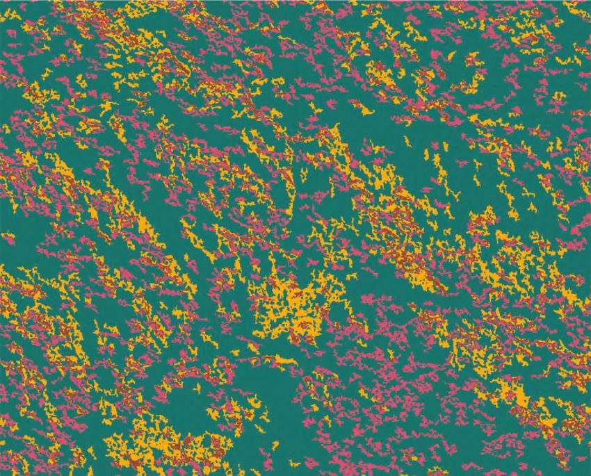
Figure 2. Map showing the 2005 segmentation output. Yellow lines illustrate how the multiresolution segmentation grouped together similar spectral values based off
the aerial imagery in 2005. The darker areas of the image represent gaps; the lighter areas represent forest.
ind21-0012_fig0286°9'58" 86°9'56" 86°9'54" 86°9'52"
LAKE SUPERIOR
2018 segmentation
area
Upper Peninsula
of Michigan
Munising
46°37'16"
EXPLANATION
2018 segmentation output
Tree canopy
Canopy gap
46°37'14"
0 0.01 0.02 MILE
0 0.01 0.02 KILOMETER
Methods 5
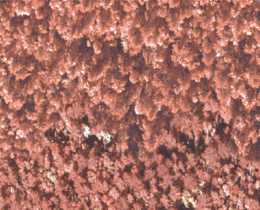
Figure 3. Map showing the 2018 segmentation output. Yellow lines illustrate how the multiresolution segmentation grouped together similar spectral values based off
the aerial imagery in 2018. The darker areas of the image represent gaps; the lighter areas represent forest.
ind21-0012_fig036 Changes in Forest Connectivity from Beech Bark Disease
Table 1. Spectral value threshold ranges used to locate dark areas (canopy gaps).
[NAIP, National Agriculture Imagery Program; n.d., no data]
2005 aerial imagery 2018 NAIP imagery
Threshold value Lower threshold Upper threshold Lower threshold Upper threshold
Brightness n.d. 85 (106) 45 85
Mean layer 1 n.d. n.d. 35 65
Mean layer 2 n.d. n.d. 35 80
Mean layer 3 n.d. 70 (80) 40 60
Mean layer 4 n.d. n.d. 65 145
Maximum difference n.d. 1.2 (1, 1.5) 0.3 1.3
Table 2. Map classes used to identify true forest canopy gaps and create the forest connectivity layer.
Map class code Map class name
FBA Black Ash-Mixed Hardwood Swamp
FBS Black Spruce/Feathermoss Forest
FCA White-cedar-Black Ash Swamp
FCC, FCM White-cedar-Boreal Conifer Mesic Forest
FCP Spruce-Fir-Aspen Forest
FCS White-cedar-(Mixed Conifer)/Alder Swamp
FCX Conifer Ruderal Forest
FDX Hardwood Ruderal Forest
FFB Balsam Fir-Paper Birch Forest
FGF Paper Birch/Fir Forest
FHB Great Lakes Hemlock-Beech-Hardwood Forest
FHC Hemlock Mesic Forest
FHM North-Central Hemlock-Hardwood Forest
FHS Hemlock-Yellow Birch Swamp Wet-Mesic Forest
FJB Jack Pine/Blueberry/Feathermoss Forest
FJF Jack Pine/Balsam Fir Forest
FJM Jack Pine-Aspen/Bush-honeysuckle Forest
FLD Black Ash-Mixed Hardwood Forest
FMB, FMF, FMM, FMY Maple-Yellow Birch Northern Hardwoods Forest
FMX Conifer-Hardwood Ruderal Forest
FPB White Pine-Mixed Deciduous/Bracken Barren Forest and Scrub
FPD Great Lakes Dune Pine Forest
FPE Conifer Plantation
FRA Red Pine-Aspen-Birch Forest
FRP Red Pine/Blueberry Dry Forest
FSF Spruce-Fir/Mountain Maple Forest
FSS, FTS Black Spruce-Tamarack/Labrador-tea Poor Swamp
FWA White Pine-Aspen - Birch Forest
FWH Great Lakes White Pine-Hemlock Forest
FWM, FWW White Pine-Red Maple Swamp
FWO White Pine-Red Oak Forest
FWP White Pine/Blueberry Dry-Mesic Forest
HPB, HPW Great Lakes Coast Pine Barrens
SSS White Pine-Mixed Deciduous/Bracken Barren Forest and ScrubMethods 7
than the minimum mapping unit, 0.026 hectares, were deleted Time Change Analysis
from the dataset. This is the minimum mapping unit used to
create the forest canopy gaps along the Mississippi and Illinois To better understand how forest connectivity has changed
River bottomland forests (Sattler and Hoy, 2020). over time because of BBD, a time change analysis was
Several attributes pertaining to the canopy gap and sur- completed. By using the Union tool in ArcMap, a polygon
rounding area of the canopy gap were applied to each canopy shapefile was created showing both forest connectivity and
gap (table 3) to help inform biologists and managers in canopy gaps for each period. A raster was created from each
making decisions based on the forest canopy gaps. Using the shapefile at a resolution of 1 meter where canopy gaps were
forest canopy gap dataset produced by Sattler and Hoy (2020), given a cell value of one and forest connectivity was given
attributes that were deemed useful were applied to each cell values of zero. The Reclassify tool was executed on each
canopy gap using the Forest Canopy Gap Locator R Script raster to allow for four values to represent each of the differ-
(Sattler, 2020a). Datasets supporting this project are available ent scenarios that could have occurred to the forest over time:
in Sattler (2020b). maintained forest canopy (forest canopy in 2005 and 2018),
To create the forest connectivity layers, the forest poly- maintained forest canopy gap (forest canopy gap in 2005 and
gons (table 2) were merged to create a forest connectivity 2018), closed forest canopy gap (forest canopy gap in 2005
layer. By using Esri’s Erase tool, the forest canopy gaps were but forest canopy in 2018), and formed forest canopy gap (for-
used to create a hole (representing the canopy gap) within est canopy in 2005 but a forest canopy gap in 2018) (table 4).
the forest canopy. The forest connectivity layer would then Then, the Raster Calculator was used to complete the time
resemble how the forest canopy would appear from a bird’s- change analysis by adding the 2018 raster to the 2005 raster.
eye view.
Table 3. Attribute names and descriptions added to the forest canopy gap shapefile.
[lidar, light detection and ranging]
Attribute name Description
G_Area Area of the canopy gap in acres
G_Perim Perimeter of the canopy gap in meters
G_APR Canopy gap area/perimeter ratio
G_Dom Dominant vegetation map class within the canopy gap taken from the vegetation map classes
in the 2005 vegetation map1
Dom_Name Map class name of the map class code in G_Dom from the 2005 vegetation map1
G_AvgHt Average height of the 2015 lidar2 returns from within the canopy gap
G_MinHt Minimum height of the 2015 lidar2 returns from within the canopy gap
G_MaxHt Maximum height of the 2015 lidar2 returns from within the canopy gap
G_NFP Percentage of the canopy gap perimeter that is nonforest
S_MjFCT Vegetation map class majority forest type (as defined in table 2) within a 150-meter buffer
of the canopy gap
MjFCT_Name Map class name of the map class code in S_MjFCT from the 2005 vegetation map1
S_PFA Percentage of the 150-meter buffer area surrounding the canopy gap that is classified as forest
in the 2005 vegetation map1
S_PWA Percentage of the 150-meter buffer area surrounding the canopy gap that is classified as water
in the 2005 vegetation map1
S_PNwNf Percentage of the 150-meter buffer area surrounding the canopy gap that is classified as neither forest
nor water in the 2005 vegetation map1
1The vegetation map used was produced by Hop and others, 2010.
2The lidar dataset used was produced by USGS, 2017.8 Changes in Forest Connectivity from Beech Bark Disease
Table 4. Raster cell value definitions and explanations on the time change analysis.
Raster cell value Definition Explanation
6 Forest canopy gap closed Identified as a canopy gap in 2005 but no longer exists in 2018
8 Forest canopy gap maintained Identified as a canopy gap in 2005 and in 2018
9 Forest canopy maintained Identified as a forest canopy in 2005 and 2018
11 Forest canopy gap formed Identified as a forest in 2005 but was identified as a canopy gap in 2018
Discussion and Conclusions the majority of new canopy gaps could be because of a single
mature canopy tree dying, possibly an American beech dying
The objective of this project was to produce multiple from BBD. Interestingly, the same map class that had the most
geospatial layers of PIRO forest connectivity to reveal the forest canopy convert to a canopy gap was the same map class
effects of BBD. By analyzing the produced forest connectivity that had the most canopy gaps close to create a forest canopy
layers at different periods during the BBD infestation, manag- at 35.23 percent. This could indicate the gap was created in
ers can have a better understanding of how forest cover and the early stages of the BBD infestation (2001), or it was there
composition have changed. PIRO managers can also model prior to the BBD infestation. There were 2.97 percent of forest
how wildlife species are responding to the forest changes, bet- canopy gaps in 2005 that remained in 2018. These gaps would
ter understand how to manage for certain species, and begin be of interest for further investigation if they are true gaps and
to plan for forest restoration. The final geospatial layers, or if they are, determining what factors are inhibiting new trees
datasets (Sattler, 2020b), illustrate a change in forest canopy from growing to fill the canopy gap could be investigated.
from 2005 to 2018. Canopy gaps, canopy gaps that formed after the 2005
The settings used in eCognition, specifically for the imagery, and maintained canopy gaps from 2005 totaled
multiresolution segmentation algorithm, detected small 11,210 acres, 15.93 percent of the forested area analyzed. The
canopy gaps but not many large canopy gaps. In addition, the average canopy gap size when combining these two scenarios
threshold spectral value ranges of dark areas (canopy gaps) was 0.03 acre, which does not meet the minimum mapping
varied within the same imagery set making it more difficult to unit of this project. This would indicate that the canopy gaps
determine a value range for forest canopy gaps to be correctly identified through the time change analysis may not be true
identified. There are also some tree canopies that had darker canopy gaps.
values than others, which led to a falsely identified forest
canopy gap. Upon visual inspection, it appears that the algo- Dataset Inaccuracies
rithm and spectral threshold values located forest canopy gaps
reliably, but it was also apparent that there were many canopy Unfortunately, this project did not collect field data to
gaps unclassified. corroborate the accuracy of the identified forest canopy gaps.
Initially, a different method utilizing the National Aeronautics
and Space Administration’s stereo pipeline (Beyer and oth-
Interpretation of Time Change Analysis ers, 2018) and Forest Canopy Gap Locator R Script (Sattler,
The time change analysis demonstrates the changes 2020a) had field data validating the accuracy of identified
the forest has undergone from 2005 to 2018 (fig. 4). Over canopy gaps. That method was determined to be incompatible
the 13-year period, 72.11 percent of the forest remained as with the 2005 aerial imagery because of insufficient camera
an intact closed canopy, where 54.11 percent of the canopy information for the imagery. Therefore, when OBIA was
remained within the FMB map class (Maple-Yellow Birch identified as the new method to identify canopy gaps, field
Northern Hardwoods Forest). From 2005 to 2018, 12.96 per- data collection was beyond the scope of the project to test how
cent (9,127 acres) of the forest in PIRO converted from a accurate the eCognition and OBIA process was at locating
forest canopy to a canopy gap (table 5). The map class that canopy gaps.
saw the most forest canopy change to a canopy gap was the Further investigation could be made with regard to the
FMB map class (Maple-Yellow Birch Northern Hardwoods eCognition settings, specifically the multiresolution segmen-
Forest) at 55.41 percent. When analyzing map classes where tation algorithm and threshold values. This may reduce the
American beech commonly grows (FHB, FHM, FMB, FMF, number of identified canopy gaps classified as either shadows
FMM, FMY, and FWO), 72.80 percent of the new canopy or dark tree canopy upon visual inspection. Some of the set-
gaps occurred in one of those forest types (table 6). The aver- tings that could be tested include lowering the scale parameter,
age size of these gaps was 0.05 acre, which could indicate that changing value threshold ranges, and conducting multiple
multiresolution segmentations.86°25'30" 86°25'0"
46°29'40" LAKE SUPERIOR
Change
detection area
Upper Peninsula
of Michigan
Munising
EXPLANATION
Change detection
Forest canopy gap closed
Forest canopy gap maintained
Forest canopy maintained
46°29'20"
Forest canopy gap formed
Discussion and Conclusions 9
0 0.125 0.250 MILE
0 0.125 0.250 KILOMETER
Figure 4. Map showing time change analysis in Pictured Rocks National Lakeshore.
ind21-0012_fig0410 Changes in Forest Connectivity from Beech Bark Disease
Table 5. Acres and hectares for each change scenario in the time change analysis.
Change scenario Acres Hectares Percentage of forest
Forest canopy gap closed 8,426 3,410 11.96
Forest canopy gap maintained 2,090 845.7 2.97
Forest canopy maintained 50,800 20,560 72.12
Forest canopy gap formed 9,127 3,694 12.96
Total 70,440 28,510 100
Table 6. Summary of map classes that contain Fagus grandifolia Ehrh. (American beech) in formed forest canopy gaps.
Map class code-name Acres Hectares Percentage of formed canopy gaps
FHB: Great Lakes Hemlock-Beech-Hardwood Forest 425.1 172.0 4.66
FHM: North-Central Hemlock-Hardwood Forest 274.6 111.1 3.01
FMB: Maple-Yellow Birch Northern Hardwoods Forest 5057 2047 55.41
FMF: Maple-Yellow Birch Northern Hardwoods Forest 119.6 48.40 1.31
FMM: Maple-Yellow Birch Northern Hardwoods Forest 621.3 251.4 6.81
FMY: Maple-Yellow Birch Northern Hardwoods Forest 141.2 57.14 1.55
FWO: White Pine-Red Oak Forest 7.32 2.96 0.08
Total 6,646 2690 72.83
Suggestions for Future Studies A comparison between two methods of identifying forest
canopy gaps would provide insight on which method is more
This study is the first step in providing biologists and accurate in locating canopy gaps within the PIRO boundary.
managers at PIRO with useful information on forest canopy The 2015 lidar dataset (U.S. Geological Survey, 2017) could
gap locations to complete wildlife studies and inform manage- be used in the Forest Canopy Gap Locator R Script (Sattler,
rial decisions. These datasets (Sattler, 2020b) provide input 2020a), and that output could be compared with the 2018 data-
on the change the forest canopy has endured during the BBD set produced in this study.
infestation. Further analysis may enhance the effectiveness Beech bark disease is still prevalent in PIRO, and likely
of the datasets created and potentially help answer questions will not be the only pest that alters tree composition in the
about forest connectivity and how wildlife species are adapt- forest. It would be beneficial to conduct future time change
ing to their changing environment. analyses to monitor forest connectivity and provide additional
To better understand the quality and accuracy of the information on the condition of the forest canopy.
OBIA method for locating forest canopy gaps, field data col- Because American beech is a common tree species in
lection would be beneficial. As stated in the previous section, several U.S. National Vegetation Classification (United States
there are inaccuracies in these datasets, and conducting an National Vegetation Classification [USNVC], 2019) forest
accuracy assessment on the 2018 imagery identified forest classification types found throughout PIRO, a future study
canopy gaps could allow the OBIA process to be updated and could focus on visiting forest canopy gaps to identify the pres-
provide a forest canopy gap dataset with lower uncertainty. ent USNVC classification. Because the USNVC classification
Further investigation into different multiresolution segmenta- was used to create the map classes in the 2005 PIRO veg-
tion settings in eCognition could also be tested to identify the etation map (for example, Tsuga canadensis - Fagus gran-
best settings (for example, scale parameter at 30 instead of difolia - (Acer saccharum) Great Lakes Forest Association
50) for locating forest canopy gaps with the provided imagery (CEGL005042) was placed in the FHB map class), a compari-
in PIRO. In addition, putting in place a proximity rule would son can be completed to gain a better understanding of how
combine smaller canopy gaps that were identified as separate the forest types are changing because of American beech loss.
gaps into one larger gap (fig. 5).86°5'35" 86°5'30"
LAKE SUPERIOR
Map area
46°37'48"
Munising Upper Peninsula
of Michigan
EXPLANATION
Polygons to be
merged together
2005 forest canopy gaps
46°37'46"
46°37'44"
Discussion and Conclusions 11
0 0.025 0.050 MILE
0 0.025 0.050 KILOMETER
Figure 5. Map showing three canopy gaps that could potentially be merged together by using an adjacency rule in a future project.
ind21-0012_fig0512 Changes in Forest Connectivity from Beech Bark Disease
Summary Nyamgeroh, B.B., Groen, T.A., Weir, J.C.M., Dimov, P., and
Zlatanov, T., 2018, Detection of forest canopy gaps from
Since the introduction of beech bark disease in Pictured very high resolution aerial images: Ecological Indicators,
Rocks National Lakeshore in 2001, the forest canopy and v. 95, part 1, p. 629–636, accessed March 3, 2020, at
composition have been changing and affecting the wildlife https://doi.org/10.1016/j.ecolind.2018.08.011.
inhabitants. It is estimated that most of the mature beech trees R Core Team, 2019, The R Project for statistical computing:
will not survive the beech bark disease, so conducting time Vienna, Austria, R Foundation for Statistical Computing.
change analyses shows how the forest canopy is changing. [Also available at https://www.R-project.org/.]
This study showed that since 2005, 9,127 acres have been con-
verted from a closed canopy to a canopy gap. Of those acres, Sattler, S.R, 2020a, Forest Canopy Gap Locator R Script:
72 percent occur in a forest type where Fagus grandifolia U.S. Geological Survey code release, https://doi.org/
Ehrh. (American beech) is a common tree species. 10.5066/P9YONHY2.
The datasets developed from this project can aide biolo-
gists and managers in quantitively understanding the eco- Sattler, S.R., 2020b, Effects of beech bark disease on for-
logical effect the beech bark disease has had on the forests est connectivity in Pictured Rocks National Lakeshore
within Pictured Rocks National Lakeshore by giving them the from 2005 to 2018: U.S. Geological Survey data release,
first quantitative measure of canopy gaps in Pictured Rocks https://doi.org/10.5066/P9EZEAYD.
National Lakeshore. Sattler, S.R., and Hoy, E.E., 2020, Forest canopy gaps identi-
fied by lidar for portions of the Mississippi and Illinois
River: U.S. Geological Survey data release, https://doi.org/
References Cited 10.5066/P9BLTSTZ.
U.S. Geological Survey, 2017, USGS Lidar Point Cloud MI
Beyer, R.A., Alexandrov, O., and McMichael, S., 2018, Ames AlgerCo 2015 LAS 2017: U.S. Geological Survey National
Stereo Pipeline: Documentation-Release 2.7.0., accessed Land Cover Database, accessed January 15, 2020, at
November 31, 2019, at https://ti.arc.nasa.gov/tech/asr/ https://viewer.nationalmap.gov/basic/.
groups/intelligent-robotics/ngt/stereo/.
United States National Vegetation Classification [USNVC],
Hop, K., Menard, S., Drake, J., Lubinski, S., and Dieck, 2019, United States National Vegetation Classification
J., 2010, National Park Service Vegetation Inventory Database, V2.03: Washington D.C., Federal Geographic
Program—Pictured Rocks National Lakeshore: Fort Collins, Data Committee, Vegetation Subcommittee, accessed
Colo., National Park Service, Natural Resource Report January 14, 2021, at https://gcc02.safelinks.pro
NPS/GLKN/NRR—2010/201, accessed November 3, tection.outlook.com/?url=http%3A%2F%2Fwww.usnvc.or
2020, at https://irma.nps.gov/DataStore/Reference/ g%2F&data=04%7C01%7Cssattler%40usgs.gov%7C7
Profile/2124843. dc620aa4ab84ec4351c08d8fea369fe%7C0693b5
ba4b184d7b9341f32f400a5494%7C0%7C0%7C637
National Park Service, 2019, Beech bark disease: National 539325093145612%7CUnknown%7CTWFpbGZsb3d8
Park Service web page, accessed January 14, 2021, at eyJWIjoiMC4wLjAwMDAiLCJQIjoiV2luMzIiLCJB
https://www.nps.gov/piro/learn/nature/beechbarkdise TiI6Ik1haWwiLCJXVCI6Mn0%3D%7C1000&sdata=
ase.htm#:~:text=Beech%20bark%20disease%20is%20th pwTFGnCSdYLQzGhat07LNkqRz9%2FOGU3f229f
e%20result%20of%20a,sharp%20mouth%20parts%20a 5AGKzE8%3D&reserved=0.
nd%20sucking%20out%20the%20sap.For additional information contact: Director, Upper Midwest Environmental Sciences Center U.S. Geological Survey 2630 Fanta Reed Road La Crosse, WI 54603 Publishing support provided by the Indianapolis Publishing Service Center
Sattler—Changes in Forest Connectivity from Beech Bark Disease—OFR 2021–1069
https://doi.org/10.3133/ofr1069
ISSN 2331-1258 (online)You can also read