Climate Change Scenario Planning to Guide Research and Resource Management at White Sands National Park - Natural Resource Report ...
←
→
Page content transcription
If your browser does not render page correctly, please read the page content below
National Park Service
U.S. Department of the Interior

Natural Resource Stewardship and Science

Climate Change Scenario Planning to Guide Research
and Resource Management at White Sands National
Park
Natural Resource Report NPS/WHSA/NRR—2021/2261
ON THE COVER
Photograph of sunset over the dune field at White Sands National Park.
Credit: NPS
Climate Change Scenario Planning to Guide Research
and Resource Management at White Sands National
Park
Natural Resource Report NPS/WHSA/NRR—2021/2261

Pamela Benjamin,1 Gregor W. Schuurman,2 David Bustos,3 M. Hildegard Reiser,4 Tom Olliff,5
Amber Runyon2
1
 National Park Service
Region 6/7/8
Landscape Conservation & Climate Change Program
Lakewood, CO
2
 National Park Service
Climate Change Response Program
Fort Collins, CO
3
National Park Service
White Sands National Park
Resource Management Program
Holloman AFB, NM
4
 National Park Service
Inventory and Monitoring Network
Chihuahuan Desert Network
New Mexico State University
Las Cruces, NM (retired)
5
 National Park Service
Region 6/7/8
Landscape Conservation & Climate Change Program
Bozeman, MT

June 2021

U.S. Department of the Interior
National Park Service
Natural Resource Stewardship and Science
Fort Collins, Colorado
The National Park Service, Natural Resource Stewardship and Science office in Fort Collins,
Colorado, publishes a range of reports that address natural resource topics. These reports are of
interest and applicability to a broad audience in the National Park Service and others in natural
resource management, including scientists, conservation and environmental constituencies, and the
public.

The Natural Resource Report Series is used to disseminate comprehensive information and analysis
about natural resources and related topics concerning lands managed by the National Park Service.
The series supports the advancement of science, informed decision-making, and the achievement of
the National Park Service mission. The series also provides a forum for presenting more lengthy
results that may not be accepted by publications with page limitations.

All manuscripts in the series receive the appropriate level of peer review to ensure that the
information is scientifically credible, technically accurate, appropriately written for the intended
audience, and designed and published in a professional manner.

This report received formal peer review by subject-matter experts who were not directly involved in
the collection, analysis, or reporting of the data, and whose background and expertise put them on par
technically and scientifically with the authors of the information.

Views, statements, findings, conclusions, recommendations, and data in this report do not necessarily
reflect views and policies of the National Park Service, U.S. Department of the Interior. Mention of
trade names or commercial products does not constitute endorsement or recommendation for use by
the U.S. Government.

This report is available in digital format from the Natural Resource Publications Management
website. If you have difficulty accessing information in this publication, particularly if using assistive
technology, please email irma@nps.gov.

Please cite this publication as:

Benjamin, P., G. W. Schuurman, D. Bustos, M. H. Reiser, T. Olliff, and A. Runyon. 2021. Climate
change scenario planning to guide research and resource management at White Sands National Park.
Natural Resource Report NPS/WHSA/NRR—2021/2261. National Park Service, Fort Collins,
Colorado. https://doi.org/10.36967/nrr-2286585.

NPS 142/175482, June 2021
                                                    ii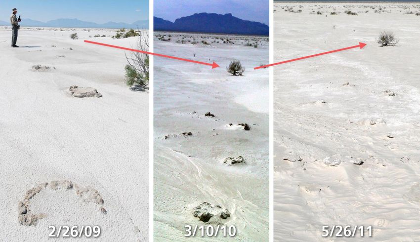
Contents
                                                                                                                                                      Page

Figures................................................................................................................................................... iv

Tables .................................................................................................................................................... vi

Appendices............................................................................................................................................ vi

Executive Summary ............................................................................................................................. vii

Acknowledgements ............................................................................................................................... ix

Workshop Purpose and Need ................................................................................................................. 1

Introduction to Scenario Planning.......................................................................................................... 2

Biophysical Systems and Climate Drivers for White Sands National Park ........................................... 4

       Biophysical Systems Drivers........................................................................................................ 11

       White Sands National Park Dune System Model ......................................................................... 13

       Key Degradation Processes for Resources at White Sands National Park ................................... 15

Climate Change Scenarios for White Sands National Park ................................................................. 16

       Climate Futures for White Sands National Park .......................................................................... 17

       White Sands National Park Climate Futures (2025–2055) – Synopses ....................................... 19

Climate Change Scenario Planning Implications for Future Research ................................................ 23

Understanding Resource Vulnerabilities and Identifying Key Research Next Steps to
Support Climate Change Adaptation at White Sands National Park ................................................... 27

Adaptation and Next Steps................................................................................................................... 30

       Post Workshop Accomplishments................................................................................................ 31

Literature Cited .................................................................................................................................... 34

                                                                             iii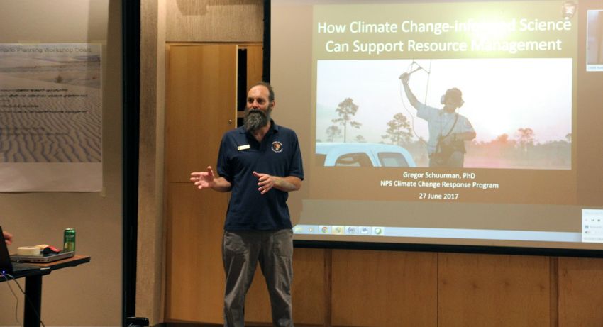
Figures
                                                                                                                                                  Page

Figure 1. Five-step scenario planning process. ..................................................................................... 2

Figure 2. Forecast-based approaches to planning (left) use predictions of a single future. .................. 3

Figure 3. WHSA, located in southern New Mexico’s Tularosa Basin, protects 40% of the
world’s largest gypsum dune field. ........................................................................................................ 4

Figure 4. Locations of major dune types at WHSA. ............................................................................. 5

Figure 5. National Aeronautics and Space Administration (NASA) image showing
gypsum-sediment particles from the White Sands dune field (center left) blowing into the
panhandles of Texas and Oklahoma, February 28, 2012. ...................................................................... 6

Figure 6. Euxoa lafantainei is one of 60 endemic moth species found at WHSA. ............................... 8

Figure 7. The endemic bleached earless lizard (Holbrookia maculate ruthveni). ................................ 8

Figure 8. Time series photographs showing the rapid erosion of fossil footprints. .............................. 9

Figure 9. Documenting and masking ice age animal and human prints before they are
lost to erosion. ...................................................................................................................................... 10

Figure 10. Conceptual model showing relationship between groundwater and moisture
wicked up in dune sand by capillary forces. ........................................................................................ 12

Figure 11. Ecosystem characterization model for the CHDN dune ecosystem. ................................. 14

Figure 12. Map of WHSA and surrounding area. ............................................................................... 16

Figure 13. The three climate futures (i.e., GCM-RCP combinations) for WHSA, chosen
to maximize divergence in terms of change in annual precipitation and annual average
temperature for the 30-year period centered on 2040, relative to the historical period
(1950–1999). ........................................................................................................................................ 18

Figure 14. Comparison of average total days/year >100°F based on historical conditions
(1950–1999) and for 2025–2055 under three selected climate futures developed for
WHSA. ................................................................................................................................................. 20

Figure 15. Comparison of average total days/year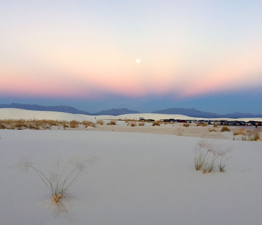
Figures (continued)
                                                                                                                                                     Page

Figure 17. Comparison of annual climatic water deficit for WHSA for the historical
period (1950–1999) and for 2025–2055 under the three climate futures developed for
WHSA. ................................................................................................................................................. 21

Figure 18. Gregor Schuurman, NPS Climate Change Ecologist, facilitated the WHSA
Scenario Planning Workshop. .............................................................................................................. 23

Figure 19. Workshop participants fill out worksheets. ....................................................................... 24

Figure 20. Workshop participants discuss potential resource impacts under three climate
futures. ................................................................................................................................................. 24

Figure 21. Female bleached earless lizards (Holbrookia maculate ruthveni) occur in
WHSA and are bright pink and orange during breeding season. ......................................................... 26

Figure 22. Key components of vulnerability, illustrating the relationship among
exposure, sensitivity, and adaptive capacity. ....................................................................................... 27

Figure 23. WHSA Scenario Planning Workshop. ............................................................................... 28

Figure 24. Adaptation framework by Stein et al. 2014. ...................................................................... 31

Figure 25. Schematic of WHSA real-time hydrology monitoring network. ....................................... 32

Figure 26. Example of real-time groundwater data taken at WHSA from late November
2018 through February 2019. ............................................................................................................... 33

Figure 27. Example of real-time sediment monitoring (sediment moisture, salinity, and
temperature) at WHSA from September 2018 through early February 2019. ..................................... 33

                                                                             v
Tables
                                                                                                                                                   Page

Table 1. Key degradation processes in the dune ecosystem, stressors, and impacts
associated with these processes, and potential measures to characterize these processes
and effects. ........................................................................................................................................... 15

Table 2. Hypothesized resource responses to climate futures for WHSA. ......................................... 25

Table 3. Examples of some workshop participant-identified research needed to better
understand resource vulnerabilities at WHSA. .................................................................................... 29

Appendices
                                                                                                                                                   Page

Appendix A. White Sands National Park Scenario Planning Workshop – List of
Participants........................................................................................................................................... 38

Appendix B. Water Balance Modeling Details.................................................................................... 40

Appendix C. Expert Worksheets for Target Resources Based on Scenarios ....................................... 43

Appendix D. Expert Opinions on the Hypothesized Resource Response to Projected
Changes in Climate for White Sands National Park ............................................................................ 45

Appendix E. Workshop Participant-Identified Research Needed to Better Understand
Climate Driven Vulnerabilities for Resources at White Sands National Park ..................................... 48

Appendix F. Accessible Table 2 .......................................................................................................... 51

                                                                            vi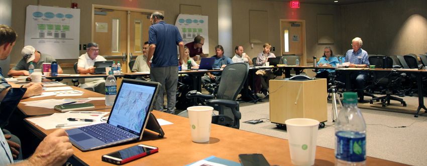
Executive Summary
White Sands National Park (WHSA), located in the northern portion of the Chihuahuan Desert,
protects 40 percent (115 square miles [mi2]) of the 275-mi2 White Sands dune field (Kocurek et al.
2006)—the world’s largest gypsum dune field. The dune field is classified as a wet aeolian system
that is intricately tied to both surface and groundwater hydrological processes. Wet sediments are
found just below dune surfaces, and groundwater typically occurs at a depth of just a few feet below
the base of the dunes. This unique system supports a diverse array of plants and wildlife, including
many endemic species. Primary ecosystem drivers for the dune field include precipitation,
groundwater hydrology, winds, floods, and droughts.

Alterations in temperatures and precipitation, as are expected with ongoing change in climatic
conditions, can significantly alter geologic and biological systems in the park. Most climate models
project a temperature increase in the southwestern US, whereas projected precipitation changes
among models include both decreases and increases. An on-site weather station in the park shows an
overall precipitation increase since 1950. The challenge for the park is how best to 1) steward park
resources in an era of rapid, directional change in fundamental drivers of ecological condition, and 2)
encourage research approaches that support and enhance understanding of key vulnerabilities.

To better inform both short- and long-term resource management and research activities, the park,
the region, the National Park Service (NPS) Chihuahuan Desert Inventory and Monitoring Network
(CHDN), the New Mexico State Climatologist’s Office, several academic institutions, and the NPS
Climate Change Response Program worked together to design and conduct the White Sands Scenario
Planning Workshop in June 2017. Workshop participants included a range of experts on climate,
hydrology, and ecology from several academic institutions, as well as the park, New Mexico State
Climatologist’s Office, and the Chihuahuan Desert Inventory and Monitoring Network. The WHSA
workshop used a refined, qualitative climate change scenario planning approach focused on expert
opinion and synthesis of pre-existing science, and solicited expert opinion from the group via a
structured process to identify and/or hypothesize impacts to resources under three divergent but
plausible climate futures: 1) Warm/No Precipitation Change, 2) Hot and Wet and 3) Hot and Dry
This process of identifying resource vulnerabilities under each climate future not only developed a
set of robust climate-resource scenarios to help guide management, but also identified key potential
vulnerabilities that need to be better understood. Specifically, wherever participants identified a
potential adverse impact to a resource under a given scenario (see Table 2) but indicated low
certainty about that resource’s vulnerability, a potential resource-specific research need has been
identified.

Participants also identified the following general research-related actions as important to better
understand climate change vulnerabilities and impacts on WHSA resources:
  ●   Integrate research among different disciplines.
  ●   Have more frequent collaborative meetings among researchers.

                                                   vii
● Enhance science communication and translation so that there is ever-improving linkage
between the information needs of the park’s decision makers and the priority science activities
to address those needs.
● Enhance baseline inventories for lesser-understood species/ecosystem components and enhance
research to meet data/information gaps.
● Enhance existing and find new funding sources to continue priority research.
Improved, scenario-based, understanding of resource vulnerabilities arising from integrated,
collaborative, priority research efforts will ultimately empower WHSA to develop adaptation
strategies to effectively steward park resources under a range of potential future climate conditions.
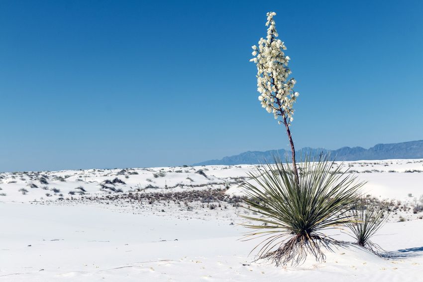
Soap tree yucca (Yucca elata) in the dunes at White Sands National Park (NPS)
viiiAcknowledgements
The authors would like to thank the NPS Climate Change Response Program for support in planning
and implementing the WHSA Scenario Planning Workshop and for providing funding for the final
publication of the technical report. Brendan Moynahan (Rocky Mountain Cooperative Ecosystems
Studies Unit) proved invaluable as peer review manager, providing oversight and guidance in
finalizing this document. We would also like to thank Don Weeks (NPS Intermountain Regional
Office) and Brian W. Miller (US Geological Survey [USGS], North Central Climate Adaptation
Science Center) for their detailed review of the technical report. Most of all, we would like to thank
the many researchers and workshop participants for their technical expertise and enthusiasm that
made the workshop highly successful.
ixWorkshop Purpose and Need
This report summarizes discussions and outcomes from a one-day climate change scenario planning
workshop for White Sands National Park (WHSA). WHSA is located southwest of Alamogordo,
New Mexico, in the Tularosa Basin, and consists of the southern part of the 275-mi2 White Sands
dune field, the largest gypsum dune field in the world.
The entire dune field is held together by sediment moisture, a biocrust, and a high-water table at the
base of the dunes (the water table occurs only a few feet below the base of the dunes). The system is
in a fragile balance because tons of gypsum are lost every year as dust, and simultaneously
replenished from new gypsum crystals resulting from large precipitation (flooding) and drying events
often associated with La Niña and El Niño.
Although a great deal of scientific investigation has taken place at the park, scientists are just
beginning to understand the complex relationships between sediment moisture in the dunes,
groundwater, and regional aquifer that sustain the unique ecology of WHSA.
The overarching goal for the workshop was to synthesize existing scientific knowledge to 1) support
climate-informed resource management in the park and 2) help guide climate-related research in the
park. To support this goal, the workshop convened a diverse group of researchers in the Tularosa
Basin who are closely associated with the park to
1.) share information about ongoing studies and explore opportunities for further research and
collaboration,
2.) explore current climate science and plausible climate futures for the region, and
3.) harness participant expertise in a process to develop climate-resource scenarios that can
inform resource management and identify critical uncertainties that require research.
To better inform both short- and long-term resource management and research activities, the park,
region, National Park Service (NPS) Chihuahuan Desert Inventory and Monitoring Network
(CHDN), New Mexico State Climatologist’s Office, several academic institutions, and the NPS
Climate Change Response Program collaborated to design and conduct the White Sands Scenario
Planning Workshop in June 2017 (see Appendix A). Workshop participants included experts on
WHSA climate, hydrology, and on the unique ecology (both biological and physical resources) of the
park.
Scenario-based understanding and actions developed by the workshop will help WHSA steward
its resources through “an era of continuous change that is not fully understood” (NPSAB 2012)
by 1) identifying key adaptation strategies that address the range of potential future climate
conditions and 2) guiding and coordinating research to strategically improve our understanding
of park resource vulnerabilities.
1Introduction to Scenario Planning
Managers cannot predict precisely how climate change will affect national parks and protected areas;
however, protected area managers can apply the most current information on climate change, work
with irreducible uncertainties, develop strategies to guard against future risk, and identify indicators
that allow them to recognize changes early. Such actions may allow managers to react to future
challenges with speed and confidence. The accelerated rate in the production of scientific
information that must be understood and conveyed challenges careful stewardship of natural and
cultural resources. Successful action in the face of climate change requires not only greater
understanding of scientific data, but also using this understanding to adaptively manage park
operations, facility management, and communications.
Figure 1. Five-step scenario planning process (©GLOBAL BUSINESS NETWORK 2010) (NPS 2013).
The National Park Service uses scenarios as an effective method to achieve these objectives (NPS
2013; Star et al. 2016; Runyon et al. 2020). A scenario is essentially a plausible, internally consistent
story about the future that challenges us to consider how we would operate under novel conditions.
Scenario work explores and describes characteristics of several plausible futures, enabling managers
to consider how to define and meet goals (desired conditions) under new and changing
2circumstances. The scenario-building process involves one or more workshops organized by a core
group of individuals and attended by key stakeholders. In advance of the WHSA Scenario Planning
Workshop, core team members interviewed workshop participants and stakeholders to understand the
assumptions, perspectives, and important management challenges associated with climate change.
The participants and core team then identified specific questions or issues to explore using scenarios.
Figure 2. Forecast-based approaches to planning (left) use predictions of a single future. Scenario
planning (right) works with a set of plausible future conditions and provides a framework to support
decisions under conditions that are uncertain and uncontrollable (NPS).
By building scenarios based on projected future climate trends and effects and their associated degree
of certainty, managers can assess relative risk, test important decisions, develop strategies or
contingency actions, and identify key indicators that can assist in signaling key changes in an
ecosystem.
The WHSA Scenario Planning Workshop provided researchers and park partners the opportunity to
identify and/or hypothesize impacts to resources in an open and integrated fashion. By using the
climate futures identified for WHSA, the scenario planning process helps focus research to support
forward-looking, climate-informed resource management.
3Biophysical Systems and Climate Drivers for White Sands
National Park
WHSA is part of the Chihuahuan Desert Ecoregion in south-central New Mexico and includes
144,000 acres of bajadas (a series of fan-shaped deposits from the deposition of sediment along a
mountain front), alkali flats, playas (areas of flat land that can temporarily hold water, but that dry up
quickly with evapotranspiration), and 40% of the world’s largest gypsum dune field (Nadeau et al.
2017). The elevation in the park ranges from 3,891 feet [ft] at Lake Lucero to 4,114 ft in the foothills
of the San Andreas Mountains on the west side of the park. Average annual precipitation is
approximately 8 inches [in] (CHDN 2017) (Figure 3).
Figure 3. WHSA, located in southern New Mexico’s Tularosa Basin, protects 40% of the world’s largest
gypsum dune field (NPS).
The unique snow-white environment that makes up WHSA is only 10,000 years old but supports a
host of remarkable and unique organisms endemic to the profoundly “white” environment of the park
(Rosenblum 2006). In addition, the dunes and gypsum-rich sediments preserve thousands of
archeological sites and globally unique late-Pleistocene human and giant megafauna fossils (Bustos
et al. 2018). At the western edge of the dune field is a large playa that is as unique as the dune field
itself. The playa is much older than the dune field and is the origin for the gypsum crystals that break
4into the fine sands that constitute the dune field. The gypsum-rich sediment of the playa also
preserves fossil human and megafauna footprints that are older than the dunes (Bustos et al. 2018). In
order to meet stewardship responsibilities, understanding which areas of the system are most
susceptible to the stresses of climate change is critical to focus research and monitoring efforts and
develop new questions and a deeper understanding of the system.
Nadeau et al. (2017) describe the WHSA dune system as being composed of four dune types,
classified according to shape: dome, barchan, transverse, and parabolic (McKee 1966; Fryberger
2001). Dome dunes represent the youngest of the dune formations and occur only on the upwind
edge of the dune field. Dome dunes are composed of fine sand, reaching only 3 to 6 ft in height, and
lacking a steep face. Dome dunes typically transition to barchan (crescent-shaped) or transverse
(straight-lined sand ridges perpendicular to the dominant wind direction) dunes. Transverse barchan
dunes occur where the dune formations align together a plane perpendicular to the wind. Parabolic
dunes are U-shaped and are formed when the centers of the dunes migrate faster than the horn or
arms of the dune (Nadeau et al. 2017). Parabolic dunes are typically older, with vegetation covering a
large portion of the sand sheet. When vegetation is destabilized, the unidirectional winds will erode
part of the dune, pushing the destabilized section leeward and creating the typical U-shape.
Figure 4 identifies the approximate locations of the four dune formation types found at WHSA. The
area identified as the “Zone of Cooperative Use” is land within the park that is also used by the
neighboring White Sands Missile Range and does not have public access.
Figure 4. Locations of major dune types at WHSA (NPS).
5The White Sands dune field is classified as a wet aeolian system, meaning that the water table depth
controls accumulation and migration or erosion of sand material (Fryberger 2001; Kocurek et al.
2007; Nadeau et al. 2017). The water table is typically sufficiently shallow to allow moisture to seep
to the surface and stabilize dune sands against wind erosion (Nadeau et al. 2017). When the dunes
dry, the gypsum sand may move exponentially (both in amount and the distance transported) with an
increase in the wind, creating dramatic dust storms (Figure 5). As local demand for groundwater
grows and the impacts of climate change increase, the shallow groundwater table that sustains the
dune field and the associated unique biological, paleontological, and archeological assemblages are
likely to become increasingly jeopardized.
Figure 5. National Aeronautics and Space Administration (NASA) image showing gypsum-sediment
particles from the White Sands dune field (center left) blowing into the panhandles of Texas and
Oklahoma, February 28, 2012. Predominant prevailing winds across the dune field are southwest-to-
northeast like this.
The landscape at WHSA is highly dynamic due to changes in sediment moisture and resulting gain of
sand through formation of new crystals and wind-driven loss of dust and sand from the basin.
Attributing current changes in the dune system to specific factors (such as climate change or external
6groundwater withdrawals) relies on understanding the driving factors and the natural range of
variability in these processes over past decades. Rachal and Dugas (2009) describe highly variable
patterns in the dune field over a 60-year period (1944–2005) suggesting, but not confirming, a trend
toward a state of disorganization. A dune modeling protocol developed by Rachal and Dugas (2009)
demonstrated that measured parameters, such as dune spacing, do change on decadal time scales,
likely in response to external factors such as precipitation and evapotranspiration. Additionally,
researchers developed a groundwater model (tied to an existing regional groundwater model) to
better understand the effects of groundwater withdrawals versus those of climate change over the
next 50 years (Newton and Allen 2014; Bourret 2015). The model showed that regional groundwater,
which likely enters the shallow system from the east, is the dominant component in the shallow dune
groundwater system. This regional groundwater component has a distinct geochemical signature and
is more than 10,000 years old. Increased pumping in Alamogordo, based on this model, will result in
water-level decline of up to 4.92 ft for the regional groundwater system near WHSA due to a change
in the evapotranspiration rate with continued climatic shifts (Newton and Allen 2014; Bourret 2015).
A significant decrease in groundwater levels in the dune aquifer system would likely make much of
the existing accumulated sand more available for transport by wind, significantly changing dune
dynamics as well as local ecosystems and habitats (Newton and Allen 2014).
Additionally, dynamics intrinsic to the dune field formation itself, such as dune-to-dune interactions,
are very common in younger dunes, which tend to show a higher degree of dune migration. In
general, dune “pattern” development (i.e., the transition of younger dune types to older dune types) is
thought to improve with development time. However, Ewing and Kocurek (2010) noted that there are
numerous boundary conditions within each of the differing dune formations in the dune field that
control how the dune organizational processes occur over time. For example, pattern organization at
WHSA may be complicated by the multiple paleo-shorelines (from Pleistocene Lake Otero), which
appear to exert a significant, if not primary, control on these patterns (Ewing and Kocurek 2010).
LiDAR surveys and detailed image analyses completed by Kocurek et al. (2012) support the
influence of boundary conditions on dune organizational patterns.
The interdunal areas (lower elevation areas between sand dunes) and the older dune formations
support most of the vegetation and wildlife found at WHSA. Dominant vegetation communities
found at WHSA include desert, semi-desert grasslands, desert scrub, and woodlands (Nadeau et al.
2017). The unique microenvironments created by the various dune formations support a rich
diversity of biological organisms. The WHSA natural resource condition assessment report (Nadeau
et al. 2017) notes that the national park is home to 289 plant species from 51 families. Vertebrates in
WHSA include 1 species of fish, 38 species of reptiles and amphibians, 52 species of mammals, and
238 species of birds. Many plant and animal species have developed highly specialized means of
surviving in this area of cold winters and hot summers, with very little surface water and highly
mineralized and brackish groundwater. Plants must also be able to withstand the climatic conditions
of the Chihuahuan Desert and successfully find sources of fresh water. They have adapted to a
constantly shifting landscape by growing fast, reproducing, and sending a new generation forward
before they are covered by a passing dune.
7The unique white gypsum environment at WHSA has given rise to many endemic species. At the top
of the lists are 60 endemic species of moths (Figure 6). According to Metzler (2014, p. 83), “The
number of endemic species of moths to White Sands National Park compared to all of North America
is the highest for a single location.”
Figure 6. Euxoa lafantainei is one of 60 endemic moth species found at WHSA (NPS).
Although the reptiles found at WHSA are typical of the Chihuahuan Desert ecoregion, this unique
white ecosystem provides habitat for numerous desert reptile species, including one endemic species,
the bleached earless lizard (Holbrookia maculate ruthveni) (Figure 7).
Figure 7. The endemic bleached earless lizard (Holbrookia maculate ruthveni) (NPS).
Additionally, WHSA has one of the world’s largest concentrations of Ice Age fossils of human and
megafauna footprints, which are unique in showing human and megafauna interactions and behavior.
For the archeological community, these provided a new form of data not previously available. Fossil
8prints also occur in the Ice Age Lake Otero, an ephemeral lake that drains a large area on the
Sacramento Mountains. Thousands of these prints have been lost to soil erosion as the lake margins
continue to dry. Lowering of the water table or soil moisture at WHSA would similarly rapidly
accelerate the erosion of these globally significant fossil footprints and associated evidence for
human and Pleistocene megafauna interactions (Figures 8 and 9).
Figure 8. Time series photographs showing the rapid erosion of fossil footprints (NPS).
9Figure 9. Documenting and masking ice age animal and human prints before they are lost to erosion
(NPS).
10Biophysical Systems Drivers
Reiser and Bustos (2014) and the Chihuahuan Desert Inventory and Monitoring Network (Nadeaus et
al. 2017) summarized information regarding biophysical drivers at WHSA. Key ecosystem drivers
derived from Reiser and Bustros (2014) are provided below.
Precipitation has an indirect influence on dunes through the recharge of groundwater, which in turn
is a key driver of dune dynamics (described below). Precipitation also enhances dune moisture,
which indurates (hardens/stabilizes) dune sediments and limits the sediment available for wind
transport. Precipitation in the dune fields is generally low (8–12 inches), and highly variable in
amount and timing among years and seasons. Recharge generally occurs during spring storms and in
late summer and early fall with the monsoonal storms (Crabaugh 1994; Langford et al. 2009).
Precipitation influences the depth to groundwater and salinity, both of which influence dune stability.
In years with high rainfall, dilution of otherwise saline groundwater may partially stabilize active
dunes. Periods of high precipitation and recurrent flooding can cause eolian aggradation of the
interdunes (Kocurek et al. 2007).
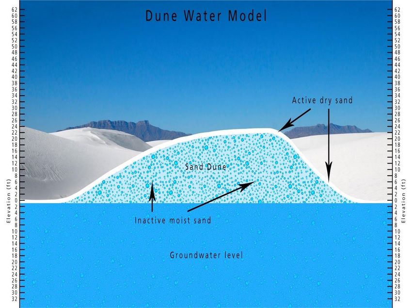
Groundwater hydrology is a key element in creating and maintaining the gypsum dune field in
WHSA (Figure 10). Groundwater brines leaching from bedded evaporites are likely an important
source of gypsum (McLean 1970; Allmendinger et al. 1973; McLean 1975; Myers 1983; Cruz 1985;
Myers and Pinckley 1987; Myers and Sharp 1989, 1992; Basabilvazo et al. 1994; Langford 2003).
Evaporation at the surface drives wicking of saline water from the shallow water table, 3–9 ft below
the surface (Allmendinger et.al. 1973). Gypsum crystallizes as a powdery efflorescence on the
surface and as small crystals at and below the surface but above the water table (Allmendinger et al.
1973). The gypsum, which constitutes the bulk of the extant dunes, was derived from deflationary
episodes when large areas of the present-day salt flats were excavated by wind during prolonged
droughts. High groundwater salinity decreases dune stability by inhibiting vegetation growth
(Langford et al. 2009). Older dunes are vegetated and stable, and portions of WHSA dunes are
estimated to have been stable for at least 3,400 years (Langford et al. 2009).
11Figure 10. Conceptual model showing relationship between groundwater and moisture wicked up in dune
sand by capillary forces (NPS).
More recently, work by Newton and Allen (2014) helped to clarify the role of the local hydrology
and dune dynamics, and demonstrated clear linkages between the shallow groundwater table,
precipitation, and nearby adjacent systems (specifically Lost River, an ephemeral stream that drains a
large area on the Sacramento Mountains). Within the dune field, depth to water in interdunal areas
ranges from 1 ft to 3 ft below the surface. Known as a wet dune system, the shallow groundwater
beneath this type of dune field directly affects dune processes. Here, groundwater effectively
stabilizes sand that has accumulated for thousands of years. At WHSA, up to 30 ft of gypsum sand is
stored below interdunal areas. A significant decrease in groundwater levels in the dune aquifer
system would likely make much of this accumulated sand more available for transport by wind,
significantly changing dune dynamics as well as local ecosystems and habitats (Newton and Allen
2014).
Winds determine the movement of sand across the dune fields (Fryberger and Dean 1979; Frank and
Kocurek 1994, 1996; Fryberger 2001). At WHSA, dominant winds from the west-southwest
transport sand to the northeast across the dune field. Frank (1994) and Frank and Kocurek (1994,
1996) examined local sand transport and wind velocities across dune elevations and found that sand
12transport was highest at the tops of the dunes. The parabolic dunes and active dune sand areas
migrate on a continuous basis, and extreme wind events accelerate their movement. The parabolic
interdunes and vegetated dune areas are stable and sufficiently vegetated such that extreme wind
events result in little to no dune movement.
Floods and droughts can dramatically change dunes. If floodwaters remain fresh or brackish, they
may result in expansion of vegetation within interdunes and the stabilization of migrating dunes
(Langford et al. 2009). On the other hand, if the fresh water mixes with saline groundwater and
becomes toxic for the local vegetation, then vegetation may be lost and dunes may migrate (Langford
et al. 2009). Extended droughts may have the most significant impacts. The geologic record shows
that the various parts of the dune field formed rapidly during short hyper-arid events. A prolonged
and significant drop and subsequent loss of available water may result in mobilization of the
parabolic interdunes and other areas that are currently stable in the park.
At WHSA, Quaternary and Holocene landforms are responsible for the current distribution of dunes
(Fryberger 2001). The older dunes currently occupy a topographic high point that was an island in a
lake that covered the landscape between 38,000 and 12,000 years ago (Seager et al. 1987; Fryberger
2001). The main dune field now occupies what was the lake floor at that time. This pluvial lake (i.e.,
a basin in which drought periods exceed wet periods), Lake Otero, formed under a cooler and wetter
climate where inflow from the surrounding mountains exceeded outflow to the groundwater. The
dune fields of WHSA currently migrate across a stepped landscape, where ancient shorelines mark
the steps. These steps also mark changes in groundwater salinity (Langford et al. 2009), sulfur
isotopes (Szynkiewicz et al. 2009), and dune morphology (Kocurek et al. 2007; Langford et al 2009).
White Sands National Park Dune System Model
Several models depict various drivers, influences, and potential response affecting the dune systems
of WHSA. Developed for the Chihuahuan Desert Inventory and Monitoring Network, the Dune
Ecosystem Characterization Model (Figure 11) provided a framework for workshop participants to
consider potential system changes and vulnerabilities.
13Figure 11. Ecosystem characterization model for the CHDN dune ecosystem. Solid ovals are drivers and interactive controls. Solid rectangles are
system components that are interactive controls. Dashed rectangles are stressors, and dotted rectangles with blue text are key degradation
processes associated with each stressor (NPS 2010).
14Key Degradation Processes for Resources at White Sands National Park
The unique biophysical systems at WHSA are highly sensitive to change. Four key degradation
processes are projected to negatively impact dune ecosystems at WHSA (Table 1) (Reiser and Bustos
2014). Climate change, groundwater withdrawal on adjacent lands, and exotic plants will increase the
salinity and change depth of groundwater. Temperature and moisture-induced stress under climatic
shifts may lead to higher plant mortality in this xeric system. Climate change will intensify these
degradation processes with the potential to significantly affect stability of the dune systems found in
the park.
Table 1. Key degradation processes in the dune ecosystem, stressors, and impacts associated with
these processes, and potential measures to characterize these processes and effects (Reiser and Bustos
2014).
Degradation Process Stressor Impacts Potential Measures
Groundwater quantity and
Climate change, exotic quality measures, land use
Altered soil-water
Increase depth to plant invasion, related to water extraction
dynamics leading to
groundwater groundwater withdrawn on on adjacent lands,
decrease in dune stability
adjacent lands abundance of exotic
species, climatic elements
Groundwater quantity and
Climate change, exotic quality measures, land use
Altered soil-water
Increase salinity of plant invasion, related to water extraction
dynamics leading to
groundwater groundwater withdrawn on on adjacent lands,
decrease in dune stability
adjacent lands abundance of exotic
species, climatic elements
Altered soil-water
dynamics leading to
decrease in dune stability, Vegetation composition
Exotic species invasion
Exotic plant invasion increase in dune stability and structure, climatic and
(plants)
where water table is atmospheric elements
unaffected, shift in
functional-group structure
Altered soil stabilization
properties leading to Vegetation composition
Climate change, air
Decrease in plant cover decrease in dune stability, and structure, climatic and
pollution
altered biotic integrity with atmospheric elements
decrease in plant cover
15Climate Change Scenarios for White Sands National Park
Management-relevant climate-resource scenarios use projected changes in resource-relevant aspects
of climate, assess projected changes against historical climate and weather events, and describe
potential consequences of plausible future climates for focal resources in the context of other
stressors. The WHSA workshop used a refined, qualitative scenario planning approach focused on
expert opinion and synthesis of pre-existing science.
The yellow square in Figure 12 is the downscaled Coupled Model Intercomparison Project phase 5
(CMIP5) (Taylor et al. 2012) grid cell used for analysis of climate at WHSA. The Coupled Model
Intercomparison Project is a collaborative framework designed to improve knowledge of climate
change. CMIP5 is a completed phase of the CMIP project (2010–2014) that improves understanding
of climate and provides estimates of future climate change. Input data included daily 1/8-degree (~8-
mi) gridded climate data, downscaled using bias-corrected constructed analog (BCCA) process
originally developed by the US Bureau of Reclamation (2013). This analysis used forty global
climate models (GCMs) for each of two greenhouse gas emission pathways (known as representative
concentration pathways [RCPs])—RCP 4.5 and RCP 8.5. Emissions in RCP 4.5 peak around 2040
and then decline. Emissions in RCP 8.5 continue to rise throughout the 21st century.
Figure 12. Map of WHSA and surrounding area. The yellow square is the downscaled Coupled Model
Intercomparison Project phase 5 (CMIP5) grid cell used for this analysis of climate, which includes the
park’s centroid.
16Climate Futures for White Sands National Park
Our exploration of the projections focused on comparisons of means calculated from future (2025–
2055) and historical (1950–1999) periods for each metric. Three plausible, divergent climate futures
were developed specifically for WHSA (and the associated Tularosa Basin). A climate future is a
summary of output from a single projection (i.e., a single GCM run for a given representative
concentration pathway) and is therefore temporally and physically coherent and plausible. The
climate futures focus on climate metrics that are relevant to park resources and to which people can
easily relate. Three climate futures were sufficient to bound the range of ways that climate could
change in this area. This suite of climate futures represents scientifically plausible alternative climate
pathways that could occur in the coming decades. Climate futures establish the fundamental structure
of climate-resource scenarios (Runyon et al. 2020) and must illustrate four key characteristics of
useful scenarios for resource management: plausibility, relevance, and divergence sufficient to
challenge existing assumptions about the way in which the future may unfold. This sets the
foundation to guide forward-looking resource management (NPS 2013). The climate futures were
defined based on projected changes in average annual temperature and total annual precipitation
(Figure 13), aspects of climate to which WHSA resources are sensitive. Potential future conditions
are characterized in terms of change relative to the historical period of 1950–1999.
17Figure 13. The three climate futures (i.e., GCM-RCP combinations) for WHSA (blue circle: MRI-
CGCM3.1.rcp85, green circle: canesm2.5.rcp85, red circle: IPSL-CM5A-MR.1.rcp85), chosen to
maximize divergence in terms of change in annual precipitation and annual average temperature for the
30-year period centered on 2040, relative to the historical period (1950–1999). Data are from two
simulations each of 40 downscaled CMIP5 GCMs for WHSA. Each model was run with a moderate (RCP
4.5) and high greenhouse gas emissions pathway (RCP 8.5) most consistent with current trends. Dashed
lines indicate the median value for each axis and the box indicates a central tendency, which is those
models inside of the 25th and 75th percentiles for each of the axes. Grey GCM/RCP combinations are
projections that were not considered for climate future selection. Colored GCM/RCP combinations are
projections selected for climate futures. The specific GCM projections chosen for climate futures are MRI-
CGCM3.1.rcp45 1, CanESM2.5.rcp85 2, and IPSL-CM5A-MR.1_rcp85 3. Circle color corresponds with the
color of the climate futures and scenarios used throughout this document.
1 The name “MRI-CGCM3.1.rcp45” is shown highlighted in blue just before the footnote marker. This note is provided to help
people with low vision, or that otherwise cannot read the word with that background color behind it, read that sentence properly.
2The name “CanESM2.5rcp85” is shown highlighted in green just before the footnote marker. This note is provided to help
people with low vision, or that otherwise cannot read the word with that background color behind it, read that sentence properly.
3The name “IPSL-CM5A-MR.1_rcp85” is shown highlighted in red just before the footnote marker. This note is provided to
help people with low vision, or that otherwise cannot read the word with that background color behind it, read that sentence
properly.
18White Sands National Park Climate Futures (2025–2055) – Synopses
● Climate Future 1 – Warm/No Precipitation Change 4
o Warming low (average annual temperature increases 1.5 degrees Fahrenheit [°F])
o >100°F 26 days/year (6-day increase)
o Annual precipitation: no change
o Water balance: annual climatic deficit (potential evapotranspiration [PET] minus actual
evaporation [AET]) increases by 7.5%
● Climate Future 2 – Hot and Wet 5
o Warming severe (average annual temperature increases 4.1°F)
o >100°F 36 days/year (16-day increase)
o Annual precipitation: 2-in increase (27%); change concentrated in July and August
o Water balance: annual climatic deficit (potential evapotranspiration minus actual
evaporation) increases 12.7%
● Climate Future 3 – Hot and Dry 6
o Warming severe (average annual temperature increases 4.1°F)
o >100°F 42 days/year (22-day increase)
o Annual precipitation: 1.5-in decrease (−17%); change distributed evenly June–December
o Water balance: Annual climatic deficit (PET-AET) increases by 26.5%
Figures 14 through 17 provide graphical representation of these three climate futures compared to
historical conditions. Factors common to all three of these climate futures include warming in all
seasons, a roughly 50% decline in daysFigure 14. Comparison of average total days/year >100°F based on historical conditions (1950–1999) and for 2025–2055 under three selected climate futures developed for WHSA. Figure 15. Comparison of average total days/year
Figure 16. Long-term average monthly precipitation for the historical period (1950–1999) and for 2025–
2055 under the three climate futures developed for WHSA.

Figure 17. Comparison of annual climatic water deficit for WHSA for the historical period (1950–1999)
and for 2025–2055 under the three climate futures developed for WHSA. Water balance model courtesy
of David Thoma (NPS).

                                                  21
Figure 14 shows a comparison of average total days/year >100°F based on historical conditions (1950–1999) and under the three selected climate futures (2025–2055) for WHSA. Compared to the historical average of 20 days/year above 100°F, the park could experience a 30% to 110% increase. Figure 15 provides a comparison of the average total days/year
Climate Change Scenario Planning Implications for Future
Research
The 1-day scenario planning workshop focused on a researcher audience because their knowledge
was critical both for developing climate futures into climate-resource scenarios that could guide
resource management and for identifying critical uncertainties regarding resource vulnerabilities.
Presentations on key scientific topics and management issues were provided to give context and
baseline information for the workshop participants. The workshop began with a brief presentation by
Davis Bustos (WHSA Resource Management Chief) to provide an (1) introduction to WHSA, (2)
update on the development of the park’s research corridor, and (3) overview of the structure and
goals for the climate change scenario planning workshop. Cheryl Mcintyre (NPS, CHDN Ecologist)
presented information on the conceptual Dune Ecosystem Model (Figure 10, NPS 2010) developed
by the NPS Chihuahuan Desert Inventory and Monitoring Network. Dave Dubois (New Mexico State
Climatologist) provided an overview on climate and climate trends for the Tularosa Basin. Gregor
Schuurman (NPS, Climate Change Response Program [CCRP] Ecologist; Figure 18) served as the
facilitator for the workshop and provided presentations on (1) how climate change-informed science
can support resource management and (2) climate change projections and implications for the
Tularosa Basin, including methods used to develop the three climate futures for use by workshop
participants to identify vulnerabilities and potential impacts to key park resources. Appendix A lists
all workshop participants and their respective affiliations.

Figure 18. Gregor Schuurman, NPS Climate Change Ecologist, facilitated the WHSA Scenario Planning
Workshop (NPS).

                                                 23
Working individually for approximately 15 minutes using pre-printed worksheets (Figure 19),
participants examined the implications of each climate future on resources represented by their own
area of expertise. For each of the three climate scenarios, the worksheet specifically asked each
technical expert to (a) identify the specific ecosystem component for which he/she possessed relevant
expertise, (b) characterize the likely resource response to the scenario, (c) define the mechanism
behind the expected resource response, (d) determine the level of certainty about the expected
resource response, and (e) identify source(s) of uncertainty regarding resource response(s). An
example of the pre-printed worksheets is provided in Appendix C.
Figure 19. Workshop participants fill out worksheets (NPS).
After participants completed initial responses to the requested worksheet information, each provided
a short presentation on hypothesized resource responses, coupled with a group discussion to further
flesh out details (Figure 20). Table 2 presents a brief overview of the hypothesized ecosystem
component responses to each of the three climate futures for WHSA, with a more detailed summary
of expert thoughts on resource responses shown in Appendix D.
Figure 20. Workshop participants discuss potential resource impacts under three climate futures (NPS).
24Table 2. Hypothesized resource responses to climate futures for WHSA.* Table F-1 is a more accessible
version of this same table that is designed specifically to be easier to read by screen reading software for
people with certain visual and cognitive impairments; or with low vision, various types of color-blindness,
or cannot read the text against some of the table cell background colors used.
Warm and
Ecosystem Component No Precipitation Change Hot and Wet Hot and Dry
Geomorphic &
Hydrological Systems
Dust Emissions
Playa Sand Source
Biocrust – Coarse
Resolution
Gypsum-Endemic Plants
Endothermic Vertebrates
Desert Bighorn Sheep
Lepidoptera spp.
Arthropods
Nematodes
* Horizontal arrows identify no change or minimal change from current condition, Down arrows identify negative
response, and up arrows identify positive response. Empty, dashed circle identifies uncertain or unknown. Blue
arrows represent a LOW level of certainty; Yellow arrows represent a MEDIUM level of certainty; Red arrows
represents a HIGH level of certainty.
All three of the climate futures would involve some level of change to at least half of the resources
examined, based on current information available and the professional opinion of subject-matter
experts present at the workshop (nearly all resources would be impacted under the two warmer
25climate futures). The least amount of potential negative/adverse impact to resources would likely
occur under the “Warm and No Precipitation Change” climate future (closest to current climatic
conditions), but the levels of certainty identified by subject experts were predominantly low or
medium due to identified needs for additional research/information. Certainty levels for resource
responses were more mixed under the “Hot and Wet” and “Hot and Dry” climate futures. These two
climate futures represent significant deviations from current/historical conditions, which allowed
experts to feel more confident about their identified potential resource impacts, again with the caveat
that additional research would better inform potential resource responses. Even though there could be
some positive (i.e., desirable) responses by some taxa under the “Hot and Wet” climate future,
experts noted that there would likely be changes in the actual species composition compared to the
current conditions. Similarly, the “Hot and Wet” climate future could also assist to minimize
excessive dust emissions. The “Hot and Dry” climate future would likely create the most significant
level of change and would represent the greatest adverse responses to all resources examined,
including unique endemic species to the park (Figure 21).
Figure 21. Female bleached earless lizards (Holbrookia maculate ruthveni) occur in WHSA and are bright
pink and orange during breeding season (NPS).
26Understanding Resource Vulnerabilities and Identifying Key
Research Next Steps to Support Climate Change Adaptation
at White Sands National Park
Understanding and responding to resource vulnerabilities in the face of uncertain change will be
critical for effective management of resources at WHSA. Specifically, increasing the park’s
understanding of (1) “which species or systems are likely to be most affected by projected changes”
and (2) “why these key resources are likely vulnerable” (see Glick et al. 2011) will help identify
appropriate adaptation strategies and actions. Glick et al. (2011) identified the key components of
vulnerability (Figure 22).
Figure 22. Key components of vulnerability, illustrating the relationship among exposure, sensitivity, and
adaptive capacity (Glick et al. 2011).
The three climatic futures presented to workshop participants provided a preliminary step to begin to
understand possible exposure scenarios for park resources. Through expert opinions and knowledge
of existing science, participants assessed the likely sensitivity and adaptive capacity of the discussed
resources (i.e., how vulnerable would resources be under the conditions of each of the three
identified futures?). Workshop participants identified the level of certainty they had in defining their
postulated resource impacts.
Based on the three climate futures examined for WHSA (higher temperatures with precipitation
conditions that will not overcome expected levels of temperature increase), participants concluded
that temperatures and climatic water deficit will likely increase at WHSA. These changes, in
combination with expected increases in evaporation rates, have the potential to significantly affect
soil moisture levels. Even if annual precipitation levels continue to increase, alteration to the timing
and/or intensity (i.e., extreme rain events) of precipitation events intermixed with prolonged periods
of drought may result in a drop in the water table and associated dune moisture levels. This could
27You can also read