Commercial Devices for a Quick and Non-Invasive 3D Survey and Geometrical Monitoring of Buildings
←
→
Page content transcription
If your browser does not render page correctly, please read the page content below
Commercial Devices for a Quick and Non-Invasive 3D Survey and
                      Geometrical Monitoring of Buildings

        Rossi PAOLO, Parente LUIGI, Mancini FRANCESCO, Grassi FRANCESCA,
       Castagnetti CRISTINA, Capra ALESSANDRO, University of Modena and Reggio
                                     Emilia, Italy

   Key words: 3D survey, mobile devices

   SUMMARY

   Modern technologies and approaches changed the way we document the real world, leading to
   an increasing demand for 3D data. The fields of application range from land, water, and
   resource management, building maintenance, to interior, mechanical and civil design. In this
   work we will mainly focus on modern strategies available for the surveying and monitoring of
   buildings. Laser scanning technology and UAV/terrestrial photogrammetry are well suited for
   a range of applications and largely used to acquire 3D datasets. Recent technological
   advances in 3D sensors and they deployment in common mobile devices, have opened the
   way to low-cost methodologies for 3D reconstruction, suitable for non-expert users and useful
   in multiple applications. The LiDAR sensors, implemented in the latest generation iPhone and
   iPad, allows to calibrate the data acquired by these devices and make it usable for 3D
   reconstruction processes. In this paper the workflows proposed by the CANVAS
   (https://canvas.io/) and PIX4D Catch (https://www.pix4d.com/product/pix4dcatch)
   applications will be assessed. The functioning of proposed methodologies will be briefly
   described, and the obtained products will be presented. Also, the relevance of proposed
   methodologies will be discussed in specific fields.

Commercial Devices for a Quick and Non-Invasive 3D Survey and Geometrical Monitoring of Buildings (11011)
Paolo Rossi, Luigi Parente, Francesco Mancini, Francesca Grassi, Cristina Castagnetti (Italy) and Alessandro Capra
FIG e-Working Week 2021
Smart Surveyors for Land and Water Management - Challenges in a New Reality
Virtually in the Netherlands, 21–25 June 2021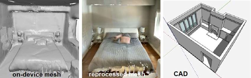
Commercial Devices for a Quick and Non-Invasive 3D Survey and
                      Geometrical Monitoring of Buildings

        Rossi PAOLO, Parente LUIGI, Mancini FRANCESCO, Grassi FRANCESCA,
       Castagnetti CRISTINA, Capra ALESSANDRO, University of Modena and Reggio
                                     Emilia, Italy

       1. INTRODUCTION

   Laser scanning technology and UAV/terrestrial photogrammetric surveys are largely used to
   acquire 3D datasets to record and document buildings conditions and can provide data for
   further design activities or maintenance planning (Alshawabkeh et al., 2020; Farahani et al.,
   2020; Boché et al., 2015; Santoso et al., 2015). These methods guarantee excellent
   performance in terms of accuracy and resolution of the result, when a remote and non-
   destructive investigation is required (Castagnetti et al., 2016), and offers many advantages
   over approaches traditionally employed for the geometrical monitoring of building such as
   contact sensors (e.g., crack meters, piezometers, etc.) and pointwise surveying techniques
   (e.g., total stations, GNSS). They can be cost and time ineffective if the monitoring of
   multiple small scale and localized damage phenomena is required (e.g., rooms, small
   excavations). Generation of 3D datasets in the form of point clouds and meshes is a critical
   requirement for numerous projects aiming at assessing and monitoring structural health
   conditions (Torok et al, 2014; Galantucci and Fatiguso, 2019).
   The potential of laser scanning systems in three-dimensional reconstruction is widely
   recognized and they have become the main solution for surveying buildings and construction
   sites (Mukupa et al., 2017). There are different models available on the market depending on
   the range, accuracy and resolution required; the laser scanner can work in static or dynamic
   configuration. Laser scanner systems can be carried by hand, mounted on tripods, trolleys,
   cars or drones. These numerous solutions make laser scanning a suitable methodology for
   multiple applications and fields of use (Kaartinen et al., 2008; Lindenbergh and Pietrzyk,
   2015). However, specific software and trained operators are required in the processing of the
   acquired data and the design of the survey.
   Image-based modelling techniques such as Structure from Motion and Multi View Stereo
   (SfM-MVS) has acquired a growing interest in the last decade due to the growing number of
   research works highlighting the quality of the generated outputs and the multiple potential
   applications (Eltner and Sofia, 2020). Main advantages of a SfM-MVS approach include area-
   based measurement, generation of both, geometry and texture coloured of the observed
   surface, flexible scale and logistically and cost-effective equipment. The main limitation of
   photogrammetric approaches when compared to active sensors are the unfeasibility to work
   with insufficient light, the need of ground measurements, the planning of specific acquisition
   patterns and the high images redundancy required.
   In order to generate a 3D model, the typical photogrammetric workflow is composed of a
   series of steps which can be summarized in four main phases including image acquisition,
   camera calibration, pre-processing of images (optional) and processing of images in dedicated

Commercial Devices for a Quick and Non-Invasive 3D Survey and Geometrical Monitoring of Buildings (11011)
Paolo Rossi, Luigi Parente, Francesco Mancini, Francesca Grassi, Cristina Castagnetti (Italy) and Alessandro Capra
FIG e-Working Week 2021
Smart Surveyors for Land and Water Management - Challenges in a New Reality
Virtually in the Netherlands, 21–25 June 2021
commercial or open-source photogrammetric software (e.g., Metashape, Pix4D, Zephyr,
   PhotoModeler, MicMac, etc.). There are many factors that may influence the quality of a 3D
   reconstruction including camera system selection, calibration, network configuration,
   acquisition procedure and survey scale, software used and external factors (e.g., site
   characteristics, weather, and light conditions, etc.) (Niederheiser et al., 2016; Mosbrucker et
   al. 2017; Parente et al., 2019; Parente et al., 2020). Despite its apparent simplicity, image
   acquisition is the first critical steps to which the quality of the final outputs depends on.
   Guidelines and strategical protocols have been described in past literature (Hiremagalur et al.,
   2007; Mosbruck et al., 2017) to achieve optimal acquisition geometry and coverage which can
   be quite misleading for unexperienced operators. Recent technological developments in
   consumer-grade devices (such as iPhones and iPads) and their LiDAR sensors, allow to ease
   the generation of 3D products. This paper is a first attempt to critically describes these
   technologies, highlighting advantages and limitations and comparing them with more-
   established techniques used for 3D survey of buildings. Two dedicated mobile apps, able to
   provide quality 3D products and a proper image pattern for photogrammetric reconstructions,
   will be discussed.

       2. MOBILE DEVICES AND APPS

            2.1.LIDAR sensor

   LiDAR scanners measure the distance from the sensor and surrounding objects and works at
   both, day and night. It is therefore a time-of-flight technology that fires low-power lasers into
   an environment. Using reflections, the system calculates the distance from objects and points
   in the environment and creates a 3D depth map.
   The use of LiDAR technology in mobile Apple devices is a bit different when compared to
   traditional laser scanning instrumentations. The basic principle is the same: bouncing light to
   determine distance but applied on a smaller scale. The LiDAR scanner in the iPhone 12 Pro
   and iPad Pro has an effective range of around 5 meters. The miniaturized LiDAR scanner uses
   a direct time of flight to measure reflected light, both indoors and outdoors. It works at the
   photon level, operates at nanosecond speeds. The depth framework combines the depth
   measurements performed by LiDAR with data from motion sensors and cameras to increase
   the accuracy and the overall quality of 3D experience.
   The primary purpose of LiDAR in Apple devices is to improve augmented reality (AR)
   implementation. It will give apps more useful and accurate information about their
   surroundings, for smoother, more reliable AR. The LiDAR Scanner also improves measure
   apps, letting users more quickly and accurately measure objects. The on-board LiDAR
   scanner takes advantage of ARKit 3.5 to allow a better understanding of external
   environments. ARKit uses the LiDAR Scanner to create a polygonal model of the physical
   environment. The LiDAR Scanner quickly retrieves depth information from a wide area in
   front of the user, so ARKit can estimate the shape of the real world without requiring the user
   to move. ARKit converts the depth information into a series of vertices that connect to form a
   mesh. The depth points measured by the LiDAR Scanner and data collected using cameras
   and motion sensors are combined and enhanced by computer vision algorithms on the A12Z

Commercial Devices for a Quick and Non-Invasive 3D Survey and Geometrical Monitoring of Buildings (11011)
Paolo Rossi, Luigi Parente, Francesco Mancini, Francesca Grassi, Cristina Castagnetti (Italy) and Alessandro Capra
FIG e-Working Week 2021
Smart Surveyors for Land and Water Management - Challenges in a New Reality
Virtually in the Netherlands, 21–25 June 2021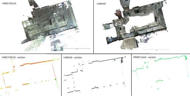
Bionic for a more detailed understanding of a scene. The tight integration of these elements
allows having a complete visualization of surrounding in 3D with an overlap of augmented
reality data (see Fig.1).
Figure 1. Functioning of LIDAR sensors, ARKit and RealityKit tools. Image credit: Apple
Several 3D apps have been implemented to use this technology and improve the quality of the
reconstruction. Some of these, go beyond a recreational use and are addressed to professional
users. Canvas by Occipital and Pix4D Catch are two examples described in more details in the
next sections.
2.2.Canvas app
Canvas is an app developed by Occipital, the company already known for the Structure
Sensor (https://structure.io/). Canvas is available for free and allows owners of LIDAR
enabled devices to obtain 3D reconstructions. Given the characteristics of the on-board
LIDAR, the system is recommended for indoor environments. By framing the walls and
moving the system into the rooms of interest (see www.canvas.io for more details about data
acquisition) a 3D mesh can be easily obtained.
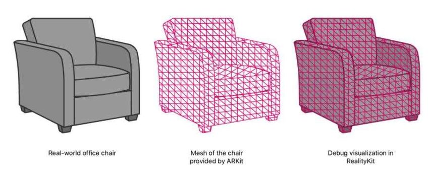
With Canvas a “digital twin” of a space of interest can be quickly created and used for
revisiting, share projects, document, perform measurements and reimagine interiors. Every
dimension and measure are detected, so revisiting and mistakes reviewing costs can be
avoided. A project with a texture less mesh is automatically stored in the device, the mesh can
be exported for free in standard format (such .ply file) for further analyses. Occipital offers
reprocessing and CAD creation services (see Fig. 2); these services require a payment of a
single fee or annual subscription. The reprocessing of the on-device mesh is performed
through more powerful algorithms than those run in real-time. During this step texture is
added to the mesh, the space can be better visualized, and the acquisition of measurements
become easier. Scan to CAD is a semi-automated service that converts reprocessed meshes
into editable CAD files (such as 2D plans, Revit or SketchUp file, …).
Commercial Devices for a Quick and Non-Invasive 3D Survey and Geometrical Monitoring of Buildings (11011)
Paolo Rossi, Luigi Parente, Francesco Mancini, Francesca Grassi, Cristina Castagnetti (Italy) and Alessandro Capra
FIG e-Working Week 2021
Smart Surveyors for Land and Water Management - Challenges in a New Reality
Virtually in the Netherlands, 21–25 June 2021Figure 2. Example of products generated by Canvas app and reprocessing services (Canvas webpage).
Canvas is optimized for residential environments. It can be successfully used also in different
spaces (for example commercial, industrial, archaeological, etc), but certain limitation factors
may influence the final result including scanning range (max of 5 m), number of scans,
presence of highly reflective, transparent, or dark surfaces, and not suitable lighting
conditions. In residential environments it is recommended to scan each room separately,
scanning through doors may increase errors. Different scans can be merged, if an overlap
between them is given, and the scan to CAD service will provide a single CAD file on the
entire home.
The accuracy of 3D scanning with mobile devices depends on the user and the environment
(enclosed spaces have a minor absolute error than large areas). If a 3D reconstruction is
required for construction purposes traditional methodologies should be used, otherwise the
need to verify Canvas model with manual measurements is critical. Experiences made by
Canvas community show a mean discrepancy of 1-2% between the final CAD and manual
measurements. If higher accuracies are required, few manual measurements can be acquired
and integrated with the 3D model when generating CAD outputs.
2.3.Pix4D Catch – an acquisition app.
In June 2020, Pix4D (a well-known company providing photogrammetry software
technology) released ‘Pix4Dcatch’ a simple and free to use mobile application for quick
acquisition of digital imagery for creating photogrammetric reconstructions. The app can be
freely downloaded for use on recent compatible iOS and Android devices. However, it is
currently optimised for the newest iPad Pro and iPhone 12 Pro and Pro Max with LiDAR
sensors. The use of the cited devices allows to provide the user with scene completion
feedback though the use of AR. The use of this app offers the opportunity to easily implement
terrestrial image acquisition with no expertise required. Also, it allows to potentially operate
in a range of different site conditions in a comprehensible and manageable way. Once the app
is up and running, the user only needs to walk around the area of interest in a recording video
mode. The app can carry out a real-time overlap calculation which allow to automatically
extract from the video the exact number of frames needed to achieve a full coverage of the
Commercial Devices for a Quick and Non-Invasive 3D Survey and Geometrical Monitoring of Buildings (11011)
Paolo Rossi, Luigi Parente, Francesco Mancini, Francesca Grassi, Cristina Castagnetti (Italy) and Alessandro Capra
FIG e-Working Week 2021
Smart Surveyors for Land and Water Management - Challenges in a New Reality
Virtually in the Netherlands, 21–25 June 2021site. Thanks to the AR, the user can easily recognise on the device’s screen the portion of the
site that still needs to be acquired or where more pictures are needed (see Fig. 3). Each
extracted frame is geotagged (GPS and IMU data from the device are collected during the
acquisition) allowing to create a georeferenced 3D model.
For the 3D reconstructions and downloading of outputs, it is critical to own a licence with
other products offered by Pix4D such as Pix4Dcloud and Pix4Dmapper which offer to store
the captured images and create the 3D models. Alternatively, pictures can even be stored on
the storage available on the device and can be later exported and used by a more experienced
user for 3D generation in the desktop software.
Figure 3. Pix4D catch during the acquisition of images. The purple area, enclosed in the black line, indicates to the user
which portion of the site was already correctly acquired.
3. PRACTICAL TEST
The above-mentioned mobile apps were tested for the 3D reconstruction of an office room of
about 100 m2 (see Fig.4). The 3D survey was performed by:
-terrestrial laser scanning (Faro Focus 3D), used as reference data.
-iPAD Pro – Canvas system.
-iPAD Pro – Pix4D Catch system.
In the investigated area, some targets were positioned to register the generated 3D models and
allow an evaluation of accuracies.
3.1 Results
Fig. 4 shows the results generated by Faro Focus, Canvas and Pix4D Catch (this last without
the processing of acquired images). The 3D mesh automatically provided by Pix4D Catch, is
used here (note that the mesh lacks in texture and is only shown as horizontal section).
Commercial Devices for a Quick and Non-Invasive 3D Survey and Geometrical Monitoring of Buildings (11011)
Paolo Rossi, Luigi Parente, Francesco Mancini, Francesca Grassi, Cristina Castagnetti (Italy) and Alessandro Capra
FIG e-Working Week 2021
Smart Surveyors for Land and Water Management - Challenges in a New Reality
Virtually in the Netherlands, 21–25 June 2021Figure 4. Generated 3D models, units: meters. Top: view of the point cloud generated by Faro Focus; textured mesh
generated by Canvas. Bottom: views of horizontal sections (some centimetres of thickness) of 3D models generated by Faro
Focus, Canvas and Pix4D Catch
The 3D point cloud generated by Faro Focus has a resolution of 6 mm at 10 m and each point
is coloured according to images acquired by the laser scanner. The scanning time was about 7
minutes, and 26100000 points were acquired (about 872 MB).
The reconstruction performed with Canvas App, after the reprocessing is a 3D textured mesh.
The acquisition required 5-10 minutes, the operator moved the iPAD within the room (as
suggested by Occipital) and a model constituted by 600000 triangles (41 MB) was obtained.
The 3D mesh showed in Fig. 4 is the results of the post-processing service provided by
Occipital with 3$ fee. The original Canvas project needs to be shared with the company, and
within one working day they send back the reprocessed model. The reprocessing is an
automatic procedure that involves all the data acquired by the device (LiDAR data, images,
and other sensors) to provide an optimized and texturized 3D mesh. Central portions of floor
and ceiling are missing in Canvas result because an acquisition focused on walls and corners
is recommended to thin the acquisition and reduce noise.
Pix4D Catch required 10-15 minutes for the survey of investigated room, an amount of about
200 images and 132 MB. The project is constituted by a log file, a GNSS file, a mesh, the
automatically acquired images, location and orientation values for each acquired images,
confidence and depth maps. In this paper only the automatically generated mesh file is shown,
the photogrammetric processing in Pix4D cloud or mapper will be addressed in future
activities of the research group.
The 3D products generated by Faro Focus and Canvas were registered to compare obtained
results. The registration was performed in Cloud Compare and resulted in an RMS of 0.11 m
Commercial Devices for a Quick and Non-Invasive 3D Survey and Geometrical Monitoring of Buildings (11011)
Paolo Rossi, Luigi Parente, Francesco Mancini, Francesca Grassi, Cristina Castagnetti (Italy) and Alessandro Capra
FIG e-Working Week 2021
Smart Surveyors for Land and Water Management - Challenges in a New Reality
Virtually in the Netherlands, 21–25 June 2021with a theoretical overlap of 75%. A view of horizontal sections extracted by Canvas (mesh)
and Faro (point cloud) is shown in Figure 5 (with red and grey lines, respectively).
Figure 5. Focus of extracted horizontal sections. Red line: Canvas mesh; grey line: Faro point cloud
4. DISCUSSIONS
All the proposed methodologies allow to obtain a complete 3D model of the investigated
room. In this discussion the results obtained with Pix4D Catch are not considered because it is
a preliminary mesh as the image processing have not been carried out yet.
The use of mobile devices allows to reduce the occlusions caused by the viewing geometry;
some parts of the adjacent rooms have also been rebuilt (see Fig.4).
Extracted sections show that the results obtained with iPAD and Canvas app are less accurate
in the definition of sharp geometries than the reference dataset, the edges are smoothed, and
the complex geometries are simplified and smoothed (see Fig. 4 and 5). A misalignment of
some portions of Canvas mesh is pointed out in Fig. 5, and a 10 centimetres rms error of the
registration between Faro point cloud and Canvas mesh was detected. We think that a deeper
investigation on detected misalignments is necessary to evaluate whether they are related to
differences in the definition of sharp geometries or to local or extensive distortions of the
Canvas’ 3D model.
The resolutions and quality of the products are very different from the reference. Canvas
methodology is well suited for surveying small areas (one room at a time) if geometric details
or high accuracy measurements are not required. If more rooms need to be surveyed, more
canvas projects need to be created. Also, an overlapping area between projects is necessary
for the subsequent merge of the products and it is strongly suggested to provide Occipital
services with some manual measurements to “constraint” and adjust the result.
These mobile 3D systems have the potential to address fields of applications different from
traditional ones, that require results (both in terms of accuracy, areal extension, and frequency
Commercial Devices for a Quick and Non-Invasive 3D Survey and Geometrical Monitoring of Buildings (11011)
Paolo Rossi, Luigi Parente, Francesco Mancini, Francesca Grassi, Cristina Castagnetti (Italy) and Alessandro Capra
FIG e-Working Week 2021
Smart Surveyors for Land and Water Management - Challenges in a New Reality
Virtually in the Netherlands, 21–25 June 2021of use) different from those provided by traditional laser scanning systems. The application of
photogrammetric techniques for the reconstruction of indoor environments is not the ideal
approach. Even using an application that controls the acquisition, difficulties in framing the
exact area of interest were experienced. Also, the need to capture a huge number of images
(200 for a single room modestly sized) slows down both, the acquisition step and the
following image processing.
5. CONCLUSION
The ease of use of the presented apps and the new chances offered by consumer grade devices
are a powerful tool for all levels of users, which enables quick data collection and 3D
reconstruction for a range of applications (e.g., building health condition assessment,
construction management, indoor crime/fire scene reconstruction, inspection of boiler room or
similar facilities, etc.). Furthermore, while on the site, an operator can easily carry out
measurements of scanned objects, add annotations and share them with other users which can
remotely access the datasets in real-time. The use of these quickly acquired datasets can offer
promising solutions for the integration of 3D information derived from different sensors also.
Quick and automated data collection can represent a suitable solution even for more expert
users to achieve good results in a time efficiency manner. Commercially available
photogrammetric software can be costly and difficult to use without proper training. The
solution offered by Pix4D catch, to automatically generate 3D models from a set of redundant
and well distributed images appears extremely significant for many fields of applications.
The purchase of a laser scanning system requires a considerable investment, including
equipment, software and staff training. For occasional use or small interventions, the choice
of simple, commercial solutions with subscription services can help calibrate the investment
according to the needs.
Despite all the advantages of using such technologies, there are several key aspects that
require further investigations. The authors are undertaking further tests and new acquisitions
in order to define repeatability (ability to generate the same outputs under similar conditions)
and accuracy (comparison with independent reference coordinates) of the two pocket-sized
solutions described in this paper.
REFERENCES
Alshawabkeh, Y., El-Khalili, M., Almasri, E., Bala’awi, F., Al-Massarweh, A. (2020).
Heritage documentation using laser scanner and photogrammetry. The case study of Qasr Al-
Abidit, Jordan. Digital Applications in Archaeology and Cultural Heritage, 16, e00133.
Bosché, F., Ahmed, M., Turkan, Y., Haas, C. T., & Haas, R. (2015). The value of integrating
Scan-to-BIM and Scan-vs-BIM techniques for construction monitoring using laser scanning
and BIM: The case of cylindrical MEP components. Automation in Construction, 49, 201-
213.
Castagnetti, C., Mancini, F., Rivola, R., Rossi, P., Oppici, S., Albano, V., & Fiorentini, M.
(2016). POTENTIALITY OF THE NEW WEARABLE SYSTEMS FOR 3D SCANNING
Commercial Devices for a Quick and Non-Invasive 3D Survey and Geometrical Monitoring of Buildings (11011)
Paolo Rossi, Luigi Parente, Francesco Mancini, Francesca Grassi, Cristina Castagnetti (Italy) and Alessandro Capra
FIG e-Working Week 2021
Smart Surveyors for Land and Water Management - Challenges in a New Reality
Virtually in the Netherlands, 21–25 June 2021AN EXPERIMENTATION OF PEGASUS BACKPACK BY LEICAGEOSYSTEMS PRESSO AT THE DUCAL PALACE OF MODENA. Archeomatica,4(2016), pp. 34-37 Eltner, A., & Sofia, G. (2020). Structure from motion photogrammetric technique. Tarolli, P., Mudd, S.M. (Eds.), Developments in Earth Surface Processes, Elsevier, 23, 1-24. Farahani, B. V., Barros, F., Sousa, P. J., Tavares, P. J., & Moreira, P. M. (2020). A railway tunnel structural monitoring methodology proposal for predictive maintenance. Structural Control and Health Monitoring, 27(8), e2587. Galantucci, R. A., & Fatiguso, F. (2019). Advanced damage detection techniques in historical buildings using digital photogrammetry and 3D surface analysis. Journal of Cultural Heritage, 36, 51-62. Hiremagalur, J., Yen, K. S., Akin, K., Bui, T., Lasky, T. A., & Ravani, B. (2007). Creating standards and specifications for the use of laser scanning in caltrans projects (No. CA07- 0964). Kaartinen, H., Hyyppä, J., Kukko, A., Jaakkola, A., & Hyyppä, H. (2012). Benchmarking the performance of mobile laser scanning systems using a permanent test field. Sensors, 12(9), 12814-12835. Lindenbergh, R., & Pietrzyk, P. (2015). Change detection and deformation analysis using static and mobile laser scanning. Applied Geomatics, 7(2), 65-74. Mohan, A., Poobal, S. (2018) Crack detection using image processing: A critical review and analysis. Alexandria Engineering Journal, 57, 787 – 798. Mosbrucker, A. R., Major, J. J., Spicer, K. R., and Pitlick, J. (2017). Camera system considerations for geomorphic applications of SfM photogrammetry. Earth Surface Processes and Landforms 42, 969–986. Mukupa, W., Roberts, G. W., Hancock, C. M., & Al-Manasir, K. (2017). A review of the use of terrestrial laser scanning application for change detection and deformation monitoring of structures. Survey review, 49(353), 99-116. Niederheiser, R., Lange, J., Petschko, H., Elberink, S.O. (2016). Deriving 3D point clouds from terrestrial photographs. Int. Arch. Photogramm. Remote Sens. Spat. Inf. Sci. XLI-B5, 12–19. Parente, L., Chandler, J. H., and Dixon, N. (2019). Optimising the quality of an SfM-MVS slope monitoring system using fixed cameras. The Photogrammetric Record, 34(168), 408– 427. Parente, L., Chandler, J. H., and Dixon, N. (2020). Automated registration of SfM‐MVS multitemporal datasets using terrestrial and oblique aerial images. Early View in The Photogrammetric Record. Santoso, F., Garratt, M. A., Pickering, M. R., & Asikuzzaman, M. (2015). 3D mapping for visualization of rigid structures: A review and comparative study. IEEE Sensors Journal, 16(6), 1484-1507. Torok, M. M., Golparvar-Fard, M., and Kochersberger, K. (2014). Post-disaster robotic building assessment: Automated 3D crack detection from image-based reconstructions. Journal of Computing in Civil Engineering, 28(5), A4014004. Commercial Devices for a Quick and Non-Invasive 3D Survey and Geometrical Monitoring of Buildings (11011) Paolo Rossi, Luigi Parente, Francesco Mancini, Francesca Grassi, Cristina Castagnetti (Italy) and Alessandro Capra FIG e-Working Week 2021 Smart Surveyors for Land and Water Management - Challenges in a New Reality Virtually in the Netherlands, 21–25 June 2021
CONTACTS

   Paolo Rossi
   University of Modena and Reggio Emilia
   Via Pietro Vivarelli 10
   Modena
   ITALY
   Tel. +39 0592056297
   Email: paolo.rossi@unimore.it
   Web site: www.geomatica.unimore.it/

   Luigi Parente
   University of Modena and Reggio Emilia
   Via Pietro Vivarelli 10
   Modena
   ITALY
   Tel. +39 0592056297
   Email: luigi.parente@unimore.it
   Web site: www.geomatica.unimore.it/

Commercial Devices for a Quick and Non-Invasive 3D Survey and Geometrical Monitoring of Buildings (11011)
Paolo Rossi, Luigi Parente, Francesco Mancini, Francesca Grassi, Cristina Castagnetti (Italy) and Alessandro Capra
FIG e-Working Week 2021
Smart Surveyors for Land and Water Management - Challenges in a New Reality
Virtually in the Netherlands, 21–25 June 2021
You can also read