CONGO, DEMOCRATIC REPUBLIC - CLIMATE RISK COUNTRY PROFILE
←
→
Page content transcription
If your browser does not render page correctly, please read the page content below
CLIMATE RISK COUNTRY PROFILE

 CONGO, DEMOCRATIC
     REPUBLIC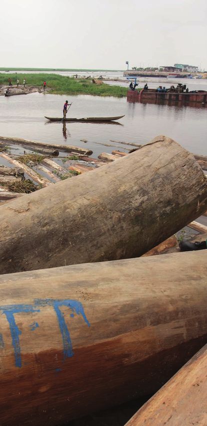
COPYRIGHT
© 2021 by the World Bank Group
1818 H Street NW, Washington, DC 20433
Telephone: 202-473-1000; Internet: www.worldbank.org

This work is a product of the staff of the World Bank Group (WBG) and with external contributions. The opinions, findings,
interpretations, and conclusions expressed in this work are those of the authors and do not necessarily reflect the views or the
official policy or position of the WBG, its Board of Executive Directors, or the governments it represents.

The WBG does not guarantee the accuracy of the data included in this work and do not make any warranty, express or implied,
nor assume any liability or responsibility for any consequence of their use. This publication follows the WBG’s practice in
references to member designations, borders, and maps. The boundaries, colors, denominations, and other information shown
on any map in this work, or the use of the term “country” do not imply any judgment on the part of the WBG, its Boards, or the
governments it represents, concerning the legal status of any territory or geographic area or the endorsement or acceptance
of such boundaries.

The mention of any specific companies or products of manufacturers does not imply that they are endorsed or recommended
by the WBG in preference to others of a similar nature that are not mentioned.

RIGHTS AND PERMISSIONS
The material in this work is subject to copyright. Because the WBG encourages dissemination of its knowledge, this work may
be reproduced, in whole or in part, for noncommercial purposes as long as full attribution to this work is given.

Please cite the work as follows: Climate Risk Profile: Congo, Democratic Republic (2021): The World Bank Group.

Any queries on rights and licenses, including subsidiary rights, should be addressed to World Bank Publications, The World Bank
Group, 1818 H Street NW, Washington, DC 20433, USA; fax: 202-522-2625; e-mail: pubrights@worldbank.org.

Cover Photos: © Flor de Preneuf/World Bank, “Timber floating on Congo River” May 18, 2013 via Flickr, Creative Commons CC
BY-NC-ND 2.0. © Vincent Tremeau/World Bank, “Aerial view of Beni, North Kivu region” January 17, 2019 via Flickr, Creative
Commons CC BY-NC-ND 2.0.

Graphic Design: Circle Graphics, Reisterstown, MD.

CLIMATE RISK COUNTRY PROFILE: CONGO, DEMOCRATIC REPUBLIC                                                                      ii
ACKNOWLEDGEMENTS
This profile is part of a series of Climate Risk Country Profiles developed by the World Bank Group (WBG). The country profile
synthesizes most relevant data and information on climate change, disaster risk reduction, and adaptation actions and policies
at the country level. The country profile series are designed as a quick reference source for development practitioners to better
integrate climate resilience in development planning and policy making. This effort is managed and led by Veronique Morin
(Senior Climate Change Specialist, WBG) and Ana E. Bucher (Senior Climate Change Specialist, WBG).

This profile was written by MacKenzie Dove (Senior Climate Change Consultant, WBG). Additional support was provided by
Yunziyi Lang (Climate Change Analyst, WBG), Fernanda Zermoglio (Senior Climate Change Consultant, WBG) and Jason
Johnston (Operations Analyst, WBG).

Climate and climate-related information is largely drawn from the Climate Change Knowledge Portal (CCKP), a WBG online
platform with available global climate data and analysis based on the latest Intergovernmental Panel on Climate Change (IPCC)
reports and datasets. The team is grateful for all comments and suggestions received from the sector, regional, and country
development specialists, as well as climate research scientists and institutions for their advice and guidance on use of climate
related datasets.

CLIMATE RISK COUNTRY PROFILE: CONGO, DEMOCRATIC REPUBLIC                                                                      iii
CONTENTS

FOREWORD  .  .  .  .  .  .  .  .  .  .  .  .  .  .  .  .  .  .  .  .  .  .  .  .  .  .  .  .  .  .  .  .  .  .  .  . 1

COUNTRY OVERVIEW .   .   .   .   .   .   .   .   .   .   .   .   .   .   .   .   .   .   .   .   .   .   .   .   .   .   .   .   .   .   .  2

CLIMATOLOGY  .   .   .   .   .   .   .   .   .   .   .   .   .   .   .   .   .   .   .   .   .   .   .   .   .   .   .   .   .   .   .   .   .   .   4
   Climate Baseline .  .  .  .  .  .  .  .  .  .  .  .  .  .  .  .  .  .  .  .  .  .  .  .  .  .  .  .  .  .  .  .  .  .  .  .  .  .  .  .           4
      Overview  .  .  .  .  .  .  .  .  .  .  .  .  .  .  .  .  .  .  .  .  .  .  .  .  .  .  .  .  .  .  .  .  .  .  .  .  .  .  .  .  .  .         4
      Key Trends .  .  .  .  .  .  .  .  .  .  .  .  .  .  .  .  .  .  .  .  .  .  .  .  .  .  .  .  .  .  .  .  .  .  .  .  .  .  .  .  .           6
   Climate Future .  .  .  .  .  .  .  .  .  .  .  .  .  .  .  .  .  .  .  .  .  .  .  .  .  .  .  .  .  .  .  .  .  .  .  .  .  .  .  .  .          7
      Overview  .  .  .  .  .  .  .  .  .  .  .  .  .  .  .  .  .  .  .  .  .  .  .  .  .  .  .  .  .  .  .  .  .  .  .  .  .  .  .  .  .  .         7
      Key Trends .  .  .  .  .  .  .  .  .  .  .  .  .  .  .  .  .  .  .  .  .  .  .  .  .  .  .  .  .  .  .  .  .  .  .  .  .  .  .  .  .           9

CLIMATE RELATED NATURAL HAZARDS .   .   .   .   .   .   .   .   .   .   .   .   .   .   .   .   .   .   .   .   .   . 10
   Overview .  .  .  .  .  .  .  .  .  .  .  .  .  .  .  .  .  .  .  .  .  .  .  .  .  .  .  .  .  .  .  .  .  .  .  .  .  .  .  .  .  .  . 10
   Key Trends .  .  .  .  .  .  .  .  .  .  .  .  .  .  .  .  .  .  .  .  .  .  .  .  .  .  .  .  .  .  .  .  .  .  .  .  .  .  .  .  .  . 12
   Implications for DRM .  .  .  .  .  .  .  .  .  .  .  .  .  .  .  .  .  .  .  .  .  .  .  .  .  .  .  .  .  .  .  .  .  .  .  .  .  . 13

CLIMATE CHANGE IMPACTS TO KEY SECTORS .   .   .   .   .   .   .   .   .   .   .   .   .   .   .   .   .   .   . 13
   Agriculture  .  .  .  .  .  .  .  .  .  .  .  .  .  .  .  .  .  .  .  .  .  .  .  .  .  .  .  .  .  .  .  .  .  .  .  .  .  .  .  .  .  . 14
   Water  .  .  .  .  .  .  .  .  .  .  .  .  .  .  .  .  .  .  .  .  .  .  .  .  .  .  .  .  .  .  .  .  .  .  .  .  .  .  .  .  .  .  .  . 17
   Forestry  .  .  .  .  .  .  .  .  .  .  .  .  .  .  .  .  .  .  .  .  .  .  .  .  .  .  .  .  .  .  .  .  .  .  .  .  .  .  .  .  .  .  . 19
   Energy  .  .  .  .  .  .  .  .  .  .  .  .  .  .  .  .  .  .  .  .  .  .  .  .  .  .  .  .  .  .  .  .  .  .  .  .  .  .  .  .  .  .  .  . 20
   Health .  .  .  .  .  .  .  .  .  .  .  .  .  .  .  .  .  .  .  .  .  .  .  .  .  .  .  .  .  .  .  .  .  .  .  .  .  .  .  .  .  .  .  . 22

ADAPTATION .   .   .   .   .   .   .   .   .   .   .   .   .   .   .   .   .   .   .   .   .   .   .   .   .   .   .   .   .   .   .   .   .   .   . 25
   Institutional Framework for Adaptation .  .  .  .  .  .  .  .  .  .  .  .  .  .  .  .  .  .  .  .  .  .  .  .  .  .  .  .  . 25
   Policy Framework for Adaptation  .  .  .  .  .  .  .  .  .  .  .  .  .  .  .  .  .  .  .  .  .  .  .  .  .  .  .  .  .  .  .  . 25
   Recommendations .  .  .  .  .  .  .  .  .  .  .  .  .  .  .  .  .  .  .  .  .  .  .  .  .  .  .  .  .  .  .  .  .  .  .  .  .  . 26
      Research Gaps .  .  .  .  .  .  .  .  .  .  .  .  .  .  .  .  .  .  .  .  .  .  .  .  .  .  .  .  .  .  .  .  .  .  .  .  .  .  . 26
      Data and Information Gaps .  .  .  .  .  .  .  .  .  .  .  .  .  .  .  .  .  .  .  .  .  .  .  .  .  .  .  .  .  .  .  .  . 26
      Institutional Gaps  .  .  .  .  .  .  .  .  .  .  .  .  .  .  .  .  .  .  .  .  .  .  .  .  .  .  .  .  .  .  .  .  .  .  .  .  .  . 27

CLIMATE RISK COUNTRY PROFILE: CONGO, DEMOCRATIC REPUBLIC                                                                                             iv
FOREWORD

Climate change is a major risk to good development outcomes, and the World Bank Group is committed to playing
an important role in helping countries integrate climate action into their core development agendas. The World
Bank Group is committed to supporting client countries to invest in and build a low-carbon, climate-resilient future,
helping them to be better prepared to adapt to current and future climate impacts.

The World Bank Group is investing in incorporating and systematically managing climate risks in development
operations through its individual corporate commitments.

A key aspect of the World Bank Group’s Action Plan on Adaptation and Resilience (2019) is to help countries
shift from addressing adaptation as an incremental cost and isolated investment to systematically incorporating
climate risks and opportunities at every phase of policy planning, investment design, implementation and evaluation
of development outcomes. For all IDA and IBRD operations, climate and disaster risk screening is one of the
mandatory corporate climate commitments. This is supported by the Bank Group’s Climate and Disaster Risk
Screening Tool which enables all Bank staff to assess short- and long-term climate and disaster risks in operations
and national or sectoral planning processes. This screening tool draws up-to-date and relevant information from
the World Bank’s Climate Change Knowledge Portal, a comprehensive online ‘one-stop shop’ for global, regional,
and country data related to climate change and development.

Recognizing the value of consistent, easy-to-use technical resources for client countries as well as to support
respective internal climate risk assessment and adaptation planning processes, the World Bank Group’s Climate
Change Group has developed this content. Standardizing and pooling expertise facilitates the World Bank Group in
conducting initial assessments of climate risks and opportunities across sectors within a country, within institutional
portfolios across regions, and acts as a global resource for development practitioners.

For developing countries, the climate risk profiles are intended to serve as public goods to facilitate upstream
country diagnostics, policy dialogue, and strategic planning by providing comprehensive overviews of trends
and projected changes in key climate parameters, sector-specific implications, relevant policies and programs,
adaptation priorities and opportunities for further actions.

It is my hope that these efforts will spur deepening of long-term risk management in developing countries and our
engagement in supporting climate change adaptation planning at operational levels.

Bernice Van Bronkhorst
Global Director
Climate Change Group (CCG)
The World Bank Group (WBG)

CLIMATE RISK COUNTRY PROFILE: CONGO, DEMOCRATIC REPUBLIC                                                             1
COUNTRY OVERVIEW
T
he Democratic Republic of the Congo, herein referred to as the DRC, is located in central sub-Saharan
Africa, within the Congo Basin. The DRC’s territory straddles the Equator, with one-third of its land area
to the north and two-thirds to the south. It is the second largest country in Africa, with a total land area
of 2,345,408 km2. The DRC shares borders with the Republic of Congo to the northwest, the Central African
Republic to the north, South Sudan to the northeast, Uganda, Rwanda, Burundi and Tanzania (Lake Tanganyika)
to the east, Zambia to the southeast and Angola to the west. The DRC has a largely equatorial climate; however,
this varies across the country’s extensive land area. Generally, the country is hot and humid in the north and
west, an area located within a significant portion
of the Congo River Basin. The southern, central
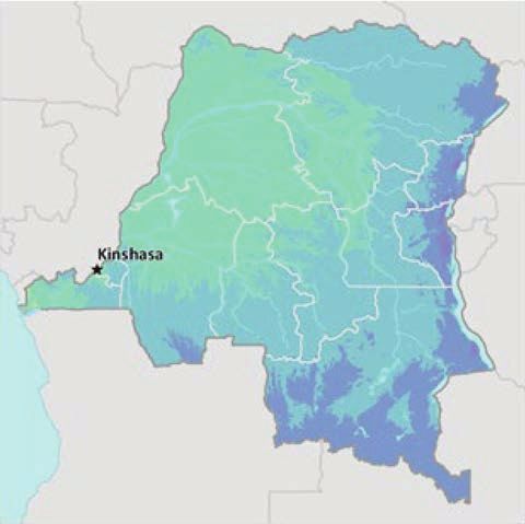
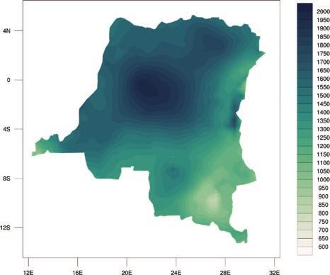
and eastern areas are generally cooler and drier.1 FIGURE 1. Topography and elevation of the DRC5
The DRC is home to an exceptionally high degree
of diversity biomes, ecosystems, and habitats,
notably dry rainforests (Muhulu), open woodland
forests (Miombo), savannahs, as well as cloud and
gallery forests. A large network of protected areas,
safeguarding this diversity, covers approximately
8% of the national territory. The majority of the land
area of the DRC is within the world’s second largest
area of tropical rainforest, which is documented to
store 8% of global forest carbon stocks.2 It is
also characterized by mountain terraces, plateaus,
savannahs, grasslands and mountains (Figure 1).3
The DRC has over 80 million hectares of arable
land and over 1,100 listed minerals and precious
metals.4 The country has a significant natural
resource base of timber, energy, minerals and
gemstones.
The DRC is endowed with exceptional natural resources, including minerals such as cobalt and copper, hydropower
potential, significant arable land, and immense biodiversity. However, the country currently has the third largest
population of poor globally. Poverty in DRC is high, remains widespread and pervasive, and is increasing due to
impacts from COVID-19. It is ranked 175 out of 189 countries on the UNDP’s Human Development Index (2020).6
The country’s extensive history of conflict, poor governance, and weak institutions pose significant development
1
Adaptation Partnership (2012). Democratic Republic of the Congo. Review of Current and Planned Adaptation Action: Middle Africa.
URL: https://www.preventionweb.net/files/25686_democraticrepublicofthecongo.pdf
2
UNDP (2019). Climate Change Adaptation – Democratic Republic of the Congo. URL: https://www.adaptation-undp.org/explore/
middle-africa/democratic-republic-congo
3
UNDP (2019). Climate Change Adaptation – Democratic Republic of the Congo. URL: https://www.adaptation-undp.org/explore/
middle-africa/democratic-republic-congo
4
World Bank (2021). DRC – Overview. URL: https://www.worldbank.org/en/country/drc/overview#1
5
World Bank (2019). Internal Climate Migration Profile – DRC.
6
UNDP (2019). Human Development Reports – Human Development Index. URL: http://hdr.undp.org/en/data
CLIMATE RISK COUNTRY PROFILE: CONGO, DEMOCRATIC REPUBLIC 2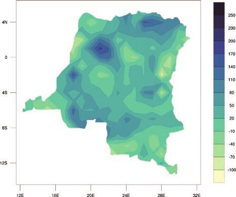
challenges. The DRC has a population of more than 86.7 million people (2019) with an annual population growth
rate of 3.2%,7 and a Gross Domestic Product (GDP) of $50.4 billion (2019) with a current annual growth rate of
4.41% (Table 1). DRC’s economic growth decelerated from its pre-COVID level of 4.4% in 2019, to an estimated
0.8% in 2020.8 Approximately 44.5% of the country’s population currently lives in urban areas. This is projected
to increase to 52% and 64% of the population by 2030 and 2050, respectively.9 The economy is largely driven
by the extractives industry and a global demand for mined products. The country’s recent economic growth (2005
to 2012) was associated with a moderate reduction in poverty. During this time, the poverty rate fell 5.3% from
69.3% in 2005 to 64% in 2012. The most recent World Bank Group estimates put the extreme poverty rate
(
The DRC submitted its Nationally-Determined Contribution to the UNFCCC in 2016, which outlines the country’s
environmental goals and its sustainable development agenda. It published its Third National Communication to the
UNFCCC in 2015. With respect to anticipated climate change impacts, the DRC’s primary adaptation efforts are
focused on the country’s most vulnerable sectors: water resources, agriculture, land use and forestry, sanitation,
health, and energy.13

Green, Inclusive and Resilient Recovery
The coronavirus disease (COVID-19) pandemic has led to unprecedented adverse social and economic impacts.
Further, the pandemic has demonstrated the compounding impacts of adding yet another shock on top of the multiple
challenges that vulnerable populations already face in day-to-day life, with the potential to create devastating health,
social, economic and environmental crises that can leave a deep, long-lasting mark. However, as governments
take urgent action and lay the foundations for their financial, economic, and social recovery, they have a unique
opportunity to create economies that are more sustainable, inclusive and resilient. Short and long-term recovery
efforts should prioritize investments that boost jobs and economic activity; have positive impacts on human, social
and natural capital; protect biodiversity and ecosystems services; boost resilience; and advance the decarbonization
of economies.

CLIMATOLOGY

Climate Baseline
Overview
The seasonal migration across the equator of the Intertropical Convergence Zone (ITCZ) drives the country’s
climate. In the equatorial climate zone, located near the Equator, temperatures are high (annual average for
Yangambi 24.6°C), humidity is high and rains fall throughout the year averaging between 1,600 mm and 2,000 mm
annually. The country’s tropical climate zones in the north and south of the equatorial zone experience more
seasonal variability, with distinct dry (April to October) and rainy (November to March) seasons that are driven by
the annual cycle of the ITCZ. Along the west coast is a small zone characterized by an oceanic climate due to the
cold Benguela Current. Here, precipitation is approximately 800 mm per year, which, along with temperatures, are
significantly lower than in the rest of the country. The highlands in the east of the country lie outside the path of
the ITCZ and are subject to the influence of the southeastern trade winds, snow commonly occurs in the highest

13
     Ministry of Environment, Nature Conservation and Tourism (2016). DRC – Nationally-Determined Contribution. URL: https://
     www4.unfccc.int/sites/ndcstaging/PublishedDocuments/Democratic%20Republic%20of%20the%20Congo%20First/CPDN%20-
     %20R%C3%A9p%20D%C3%A9m%20du%20Congo.pdf

CLIMATE RISK COUNTRY PROFILE: CONGO, DEMOCRATIC REPUBLIC                                                                        4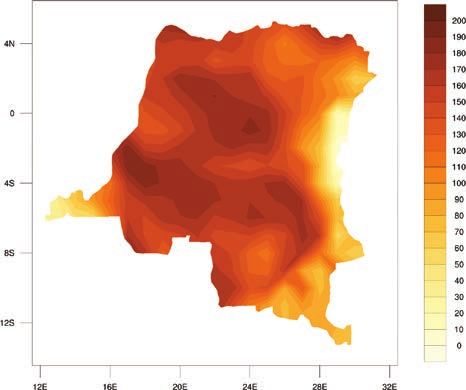
altitudes. Climate variability and change are likely to exacerbate existing vulnerabilities, political instability and
 conflict, food insecurity and the existing high poverty rates. Food security is of primary concern as the majority of
 the country’s agriculture is primarily rainfed and conducted by small-holder farmers.14

 Analysis of data from the World Bank Group’s Climate Change Knowledge Portal (CCKP) (Table 2) shows historical
 climate information for the period between 1901–2020. Mean annual mean temperature for the DRC are 24.1°C,
 with average monthly temperatures ranging between 24.6°C (March) and 22.9°C (July). Mean annual precipitation
 is 1,508.3 mm. with rain falling throughout the year, as shown in the latest climatology, 1991–2020 (Figure 3).15
 More rainfall is received in the east of the country and is fairly constant along the equator.16 Figure 4 shows the
 spatial representation of the average annual precipitation and temperature across the DRC.

 TABLE 2.  Data snapshot: Summary statistics

        Climate Variables                                                                    1901–2020
        Mean Annual Temperature (°C)                                                             24.1°C
        Mean Annual Precipitation (mm)                                                       1,508.3 mm
        Mean Maximum Annual Temperature (°C)                                                     29.7°C
        Mean Minimum Annual Temperature (°C)                                                     18.5°C

 FIGURE 3.  Average monthly temperature and rainfall of DRC for 1991–202017
                    25.6                                                                                   240
Temperature (°C)

                    24.8                                                                                   160
                                                                                                                 Rainfall (mm)

                      24                                                                                   80

                    23.2                                                                                   0
                           Jan    Feb   Mar    Apr    May   Jun    Jul    Aug   Sep    Oct    Nov   Dec

                                                     Rainfall        Temperature

 14
                   Climate Services Center Germany (2016). Climate Fact Sheet – Democratic Republic of the Congo.
 15
                   WBG Climate Change Knowledge Portal (CCKP, 2021). DRC. URL: https://climateknowledgeportal.worldbank.org/country/congo-
                   democratic-republic/climate-data-historical
 16
                   Ministry of Foreign Affairs (2018). Climate Change Profile – Democratic Republic of the Congo. URL: https://reliefweb.int/sites/
                   reliefweb.int/files/resources/DRC%2B%28east%29.pdf
 17
                   WBG Climate Change Knowledge Portal (CCKP, 2021). DRC URL: https://climateknowledgeportal.worldbank.org/country/congo-
                   democratic-republic/climate-data-historical

 CLIMATE RISK COUNTRY PROFILE: CONGO, DEMOCRATIC REPUBLIC                                                                                             5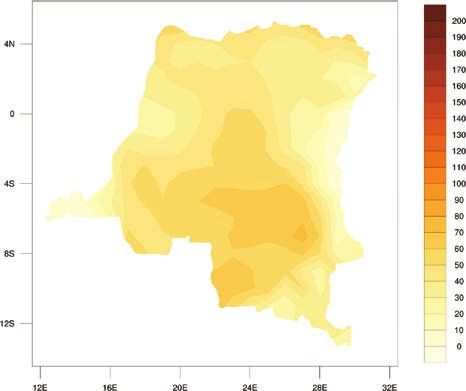
FIGURE 4.  Map of average annual temperature (°C) (left); annual precipitation (mm) (right) for the
 DRC, 1991–202018

 Key Trends
 Temperature
 In the northern and central to southwestern areas, near the capitol city of Kinshasa, temperature is relatively stable
 ranging between 24–25°C (Figure 5). The subtropical savannahs in the south and southeast experience slightly
 lower average temperatures of 22–23°C. Between 1901 and 2013 a small increase in temperature (0.05°C per
 decade) was observed, which was stronger over the last 30 years (0.17°C per decade). Additionally, the temperature
 of deep lake waters of Lake Tanganyika has increased by 0.2°C to 0.7°C since the 1960s.19

 FIGURE 5.  Observed temperature for the DRC, 1901–202020
                       25
                    24.75
Temperature (°C)

                     24.5
                    24.25
                       24
                    23.75
                     23.5
                       1901       1911       1921      1931      1941      1951      1961       1971      1981      1991      2001      2011      2020
                               Annual mean           Smoothed

 18
                   WBG Climate Change Knowledge Portal (CCKP, 2021). DRC, Historical Climate. URL: https://climateknowledgeportal.worldbank.org/
                   country/congo-democratic-republic/climate-data-historical
 19
                   USAID (2018). Climate Risk Profile - DRC. URL: https://www.climatelinks.org/resources/climate-risk-profile-democratic-republic-congo
 20
                   WB Climate Change Knowledge Portal (CCKP, 2021). DRC URL: https://climateknowledgeportal.worldbank.org/country/
                   congo-democratic-republic/climate-data-historical

 CLIMATE RISK COUNTRY PROFILE: CONGO, DEMOCRATIC REPUBLIC                                                                                             6
Precipitation
The northern areas of the country, dominated by tropical forests along the Congo River are characterized by two
rainy seasons (March to May and September to December). The Central and southeastern areas, which include
mountain terraces and grasslands, have one rainy season (July to August), while the subtropical savannahs also
have a single season, which occurs between December and February. Rainfall is highly variable across the country
and since the 1960s no substantial overall changes in rainfall are observed.21
Climate Future
Overview
The main data source for World Bank Group’s Climate Change Knowledge Portal (CCKP) is the CMIP5 (Coupled
Inter-comparison Project No.5) data ensemble, which builds the database for the global climate change projections
presented in the Fifth Assessment Report (AR5) of the Intergovernmental Panel on Climate Change (IPCC). Four
Representative Concentration Pathways (i.e. RCP2.6, RCP4.5, RCP6.0, and RCP8.5) were selected and defined by
their total radiative forcing (cumulative measure of GHG emissions from all sources) pathway and level by 2100. The
RCP2.6 for example represents a very strong mitigation scenario, whereas the RCP8.5 assumes business-as-usual
scenario. For more information, please refer to the RCP Database. For simplification, these scenarios are referred to as
a low (RCP2.6); a medium (RCP4.5) and a high (RCP8.5) emission scenario in this profile. Table 3 provides CMIP5
projections for essential climate variables under high emission scenario (RCP 8.5) over 4 different time horizons.
Figure 6 presents the multi-model (CMIP5) ensemble of 32 Global Circulation Models (GCMs) showing the projected
changes in annual precipitation and temperature for the periods 2040–2059 and 2080–2099.
TABLE 3. Data snapshot: CMIP5 ensemble projections
Cmip5 Ensemble Projection 2020–2039 2040–2059 2060–2079 2080–2099
Annual Temperature Anomaly (°C) +0.5 to +1.4 +1.2 to +2.4 +2.0 to +3.7 +2.7 to +5.1
(+1.0°C) (+1.7°C) (+2.5°C) (+3.5°C)
Annual Precipitation Anomaly (mm) -13.7 to +21.6 -17.1 to +25.2 -17.0 to +34.0 -17.8 to +44.0
(2.6 mm) (3.5 mm) (6.7 mm) (10.5 mm)
Note: The table shows CMIP5 ensemble projection under RCP8.5. Bold value is the range (10th–90th Percentile) and values in parentheses
show the median (or 50th Percentile).
21
Climate Services Center Germany (2016). Climate Fact Sheet – Democratic Republic of the Congo
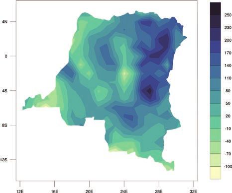
CLIMATE RISK COUNTRY PROFILE: CONGO, DEMOCRATIC REPUBLIC 7FIGURE 6. CMIP5 ensemble projected change (32 GCMs) in annual temperature (top) and
precipitation (bottom) by 2040–2059 (left) and by 2080–2099 (right), relative to 1986–2005
baseline under RCP8.522
22
WBG Climate Change Knowledge Portal (CCKP, 2021). DRC Projected Future Climate. URL: https://climateknowledgeportal.
worldbank.org/country/congo-democratic-republic/climate-data-projections
CLIMATE RISK COUNTRY PROFILE: CONGO, DEMOCRATIC REPUBLIC 8Key Trends
Temperature
Annual temperatures in DRC are projected to increase, between +1.7°C to +4.5°C by end of the century. Heat
waves are projected to become more common and longer-lasting.23 Hot days and nights are projected to increase
13–58% and 33–86%, respectively. Additionally, cold days and nights are projected to decrease by 6–10% by
the end of the century.24
Across all emission scenarios, temperatures will continue to rise across the DRC through the end of the century
(Figure 7). Under a high-emission scenario (RCP 8.5), average temperatures will rise rapidly by mid-century. The
highest rise in temperature is projected for the period between October to March (Figure 8). Rising heat and more
frequent and intense extreme heat conditions will result in significant implications for human and animal health,
agriculture, water resources, and ecosystems.
FIGURE 7. Historical and projected average FIGURE 8. Projected change in summer days
temperature for the DRC from 1986 to 2099 (Tmax >25°C) (RCP8.5, Reference Period,
(Reference Period, 1986–2005)25 1986–2005)26
30 2.5
29 2.0
28 1.5
Temperature (°C)
27
1.0
Days
26
0.5
25
0
24
–0.5
23
1980 2000 2020 2040 2060 2080 2100 –1.0
Year Jan Feb Mar Apr May Jun Jul Aug Sep Oct Nov Dec
Historical RCP 2.6 RCP 4.5 RCP 6.0 RCP 8.5
23
Climate Services Center Germany (2016). Climate Fact Sheet – Democratic Republic of the Congo
24
Ministry of Foreign Affairs (2018). Climate Change Profile – Democratic Republic of the Congo. URL: https://reliefweb.int/sites/
reliefweb.int/files/resources/DRC%2B%28east%29.pdf
25
WBG Climate Change Knowledge Portal (CCKP, 2021). Interactive Climate Indicator Dashboard - Agriculture. DRC. URL https://
climatedata.worldbank.org/CRMePortal/web/agriculture/crops-and-land-management?country=COD&period=2080-2099
26
WBG Climate Change Knowledge Portal (CCKP, 2021). Interactive Climate Indicator Dashboard - Agriculture. DRC. URL https://
climatedata.worldbank.org/CRMePortal/web/agriculture/crops-and-land-management?country=COD&period=2080-2099
CLIMATE RISK COUNTRY PROFILE: CONGO, DEMOCRATIC REPUBLIC 9Precipitation
The meteorological network and record of observations
across DRC is scarce, posing a challenge for FIGURE 9. Projected changes in average
projections of future rainfall. While projections point annual across the DRC for the period between
to no significant changes in annual precipitation 1986 to 2099 (Reference Period, 1986–2005)31
(Figure 9),27 rainfall is projected to become substantially 2600
more variable, with a likely increase in frequency and 2400
intensity of extreme rainfall events. This is expected 2200
Precipitation (mm)
to have a negative impact on agriculture, water, energy, 2000
forestry, and health, as well as on available agricultural 1800
land, freshwater resources and ecosystems.28 The 1600
rainfall intensity of heavy rain events is likely to 1400
increase by as much as 27%.29 Seasonally, more
1200
rainfall is expected to fall during the already wet 1980 2000 2020 2040 2060 2080 2100
Year
season that occurs between October and April. This Historical RCP 2.6 RCP 4.5 RCP 6.0 RCP 8.5
is likely to translate into longer lasting dry spells.
Impacts will be most pronounced via changes in the
country’s water balance and are likely to increase the incidence of floods.30 Natural disasters driven by more
frequent and more intense floods and droughts are projected to increase in number.
CLIMATE RELATED NATURAL HAZARDS
Overview
The DRC is at risk for many natural hazards, including volcanic eruptions, earthquakes, floods, and droughts.
Vulnerability to these hazards is exacerbated by poverty and political insecurity. Since 1997, millions of people
entered conditions of acute vulnerability due to displacement, loss of economic livelihoods, and a fraying social
fabric. Two volcanoes of the Virunga volcanic chain are some of the most active volcanoes in the world and pose a
direct threat to more than one million inhabitants in the city of Goma and surroundings areas. In 2002, a volcanic
eruption covered 13% of the city’s surface area, destroying 80% of the local economy. The DRC also experiences
extreme weather and climate variability, resulting in a high exposure to floods and droughts, which are projected
to increase in frequency and severity due to climate change.32 The most common natural disasters are floods and
27
WBG Climate Change Knowledge Portal (CCKP, 2021). DRC Water Dashboard. Data Description. URL: https://climateknowledgeportal.
worldbank.org/country/congo-democratic-republic/climate-sector-water
28
Climate Services Center Germany (2016). Climate Fact Sheet – Democratic Republic of the Congo
29
Ministry of Foreign Affairs (2018). Climate Change Profile – Democratic Republic of the Congo. URL: https://reliefweb.int/sites/
reliefweb.int/files/resources/DRC%2B%28east%29.pdf
30
Climate Services Center Germany (2016). Climate Fact Sheet – Democratic Republic of the Congo
31
WBG Climate Change Knowledge Portal (CCKP, 2021). Climate Data-Projections. DRC. URL: https://climateknowledgeportal.
worldbank.org/country/congo-democratic-republic/climate-sector-water
32
GFDRR (2019). Overview – Congo, Democratic Republic. URL: https://www.gfdrr.org/en/congo-democratic-republic
CLIMATE RISK COUNTRY PROFILE: CONGO, DEMOCRATIC REPUBLIC 10heavy rainfall events and droughts. Excess rainfall is projected to be strongest in the central areas of the country,
with increased aridity and droughts forecast for the southern zones. Heavy rainfall is also projected to result in
flooding, causing river bank erosion and/ or overflows, landslides and waterlogging of agricultural fields, leading
to likely crop failures.33 The most impactful natural disasters in the DRC have been floods and epidemics which
accounted for 27% and 58% of all disasters, respectively.34 Lower-income populations tend to reside in more
hazard prone locations, with high potential for significantly increased exposure of already vulnerable populations.35
Food security will be affected by land and infrastructure degradation due to erosion/landslides, a rise in livestock
and crop diseases due to temperature increases, direct crop failure due to floods and heavy rains, and possible
nutrient leaching and fungal growth due to high humidity. Water availability will be affected by possible periods
of drought in the southern zones, but no serious water stress is projected for agriculture areas in the east of the
country. In urban areas, increasing population density combined with erratic rainfall may lead to water stress as
lifeline services fail to keep up with demand. Vulnerability from these hazards pose major challenges for economic
and political stability and the longer-term fiscal sustainability of the DRC.
Data from the Emergency Event Database: EM-Dat database,36 presented in Table 4, shows the country has
endured various natural hazards, including floods, landslides, wildfires, and storms.
TABLE 4. Natural disasters in the DRC, 1900–2020
Natural Hazard Events Total Total Damage
1900–2020 Subtype Count Deaths Total Affected (’000 USD)
Drought Drought 2 0 800,000 0
Earthquake Ground Movement 5 53 23,161 7,200
Bacterial Disease 43 5,834 193,396 0
Epidemic
Viral Disease 28 11,731 801,845 0
Flash Flood 4 206 95,385 15,000
Flood
Riverine Flood 19 245 547,598 0
Landslide Landslide 8 434 2,543 0
Convective Storm 3 24 75,147 0
Storm
Tropical Cyclone 1 17 22,500 0
Volcanic Activity Ash Fall 3 347 170,400 9,000
Wildfire Land Fire (brush, 3 11 59,898 0
bush, pasture)
33
Ministry of Foreign Affairs (2018). Climate Change Profile – Democratic Republic of the Congo. URL: https://reliefweb.int/sites/
reliefweb.int/files/resources/DRC%2B%28east%29.pdf
34
IUCN (2016). Regional assessment of Ecosystem-based Disaster Risk Reduction and Biodiversity in West and Central Africa.
URL: https://portals.iucn.org/library/sites/library/files/documents/2016-082.pdf
35
Ministry of Foreign Affairs (2018). Climate Change Profile – Democratic Republic of the Congo. URL: https://reliefweb.int/sites/
reliefweb.int/files/resources/DRC%2B%28east%29.pdf
36
EM-DAT: The Emergency Events Database - Universite catholique de Louvain (UCL) - CRED, D. Guha-Sapir, Brussels, Belgium.
URL: http://emdat.be/emdat_db/
CLIMATE RISK COUNTRY PROFILE: CONGO, DEMOCRATIC REPUBLIC 11Key Trends
Climate change is projected to increase the risk and intensity of floods, as more rainfall will be received during heavy
rainfall events. The likelihood of mudslides and landslides, particularly in the country’s mountainous areas is likely to
increase. As rainfall becomes more intense, soil erosion and waterlogging of fields could translate into decreased
yields and increase food insecurity. Rising temperatures are also likely to extend periods of aridity, especially in the
vulnerable south. Importantly, higher temperatures and drought will negatively impact water storage capacity, which
could in significant economic losses, damage to agricultural lands and infrastructure as well as human casualties.
Land degradation and soil erosion, exacerbated by recurrent floods, adversely impact agricultural production,
disproportionately affecting the livelihoods of the rural poor. The country’s recurrent political instability and poverty
will further exacerbate these issues with potential to also exacerbate potential for violence and conflict.37 Figure 10
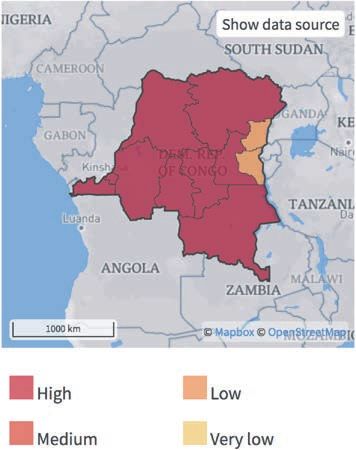
show the risks of flooding and other natural disaster risks, such as wildfires, across the country.
FIGURE 10. Risk of river flood (left)38; risk of wildfire (right)39
Deforestation, watershed degradation, land use changes, urbanization and poor management of growing settlements
have exacerbated the impact from floods and droughts. These conditions also contribute to water scarcity and pollution,
limiting water for drinking, agriculture, and other uses. Heavy rainfall can also trigger riverine, coastal and flash floods.
Heavy rainfall and flash floods are common in the country’s mountain areas and can also trigger landslides and
mudslides. Increasing urbanization, into flood plains and/or low-lying areas also has increased flood risk, as functioning
37
Ministry of Foreign Affairs (2018). Climate Change Profile – Democratic Republic of the Congo. URL: https://reliefweb.int/sites/
reliefweb.int/files/resources/DRC%2B%28east%29.pdf.
38
ThinkHazard! (2019). DRC River Flood. URL: http://thinkhazard.org/en/report/68-democratic-republic-of-the-congo/FL
39
ThinkHazard! (2019). DRC Urban Flood. URL: http://thinkhazard.org/en/report/68-democratic-republic-of-the-congo/WF
CLIMATE RISK COUNTRY PROFILE: CONGO, DEMOCRATIC REPUBLIC 12water drainage systems are nearly non-existent. Water stress may be further exacerbated with competing demands
between household consumption and agriculture, which may necessitate the building of dams and irrigation networks.
Increased heat will further strain water resources and impacts from changing rainfall patterns.40
Implications for DRM
The government of the DRC is currently working with the United Nations Development Program to develop the
country’s first disaster risk reduction policy and to strengthen its disaster risk management capabilities. The country’s
latest National Strategic Development Plan (Plan National Stratégique de Développement) (2019–2023)
includes climate adaptation and disaster risk management (DRM) as a core pillar. However, limited tracking of the
government’s budget for disaster risk reduction poses a challenge. Priorities for the country’s DRM agenda include:
(i) improving national capacity to monitor and forecast hazards and transfer this information into decision making
and planning;
(ii) strengthening early warning systems and contingency planning; and,
(iii) strengthening national institutional capacity for DRM.
At the national level, training programs are ongoing to support institutional capacity to prepare for, manage, and
respond to key natural disasters, primarily those related to volcanic activities in the Goma region. The DRC would
also greatly benefit from investments in hydro-meteorological observations and related services, which can increase
the accuracy and quality of forecasted natural disaster events.41
CLIMATE CHANGE IMPACTS TO KEY SECTORS
T
he DRC is highly vulnerable to seasonal variability as well as long-term climate change. As vulnerability
rises, so will the political, security, social, economic and environmental cumulative impacts. Droughts and
floods in particular are likely to have significant consequences on the environment, society, the food security
situation, and the wider economy. Significant impacts are projected for the country’s water resources, agriculture,
health, and forestry sectors. Additionally, heavy rains, floods, drought, and soil erosion places urban and rural
infrastructure at risk, particularly those serving the poor and vulnerable groups. Environmental degradation, changes
in water resources, and loss of biodiversity and ecosystem services constitute serious obstacles to the country’s
continued development. Changes in precipitation patterns can have far-reaching consequences for ecosystems and
biodiversity, food production, the water industry and rivers.42 Climate variability and change are likely to exacerbate
40
Ministry of Foreign Affairs (2018). Climate Change Profile – Democratic Republic of the Congo. URL: https://reliefweb.int/sites/
reliefweb.int/files/resources/DRC%2B%28east%29.pdf
41
GFDRR (2019). Overview – Congo, Democratic Republic. URL: https://www.gfdrr.org/en/congo-democratic-republic
42
Ministry of Environment, Nature Conservation and Tourism (2016). DRC – Nationally-Determined Contribution. URL: https://
www4.unfccc.int/sites/ndcstaging/PublishedDocuments/Democratic%20Republic%20of%20the%20Congo%20First/CPDN%20-
%20R%C3%A9p%20D%C3%A9m%20du%20Congo.pdf
CLIMATE RISK COUNTRY PROFILE: CONGO, DEMOCRATIC REPUBLIC 13these concerns, as the majority of agricultural production is rainfed, providing livelihoods for a large part of the
population. Rising temperatures and more variable rainfall will also impact the country’s forests, which are critical
to rural livelihoods, and the ecosystem services they provide, which are already under threat from land use changes
and a growing demand for charcoal and tropical forest products. More extreme weather events such as intense
rainfall after prolonged dry spells can lead to erosion and flash flooding, damage roads and infrastructure, wipe out
crops and put additional lives at risk.43
Gender
An increasing body of research has shown that climate-related disasters have impacted human populations in many
areas including agricultural production, food security, water management and public health. The level of impacts
and coping strategies of populations depends heavily on their socio-economic status, socio-cultural norms, access
to resources, poverty as well as gender. Research has also provided more evidence that the effects are not gender
neutral, as women and children are among the highest risk groups. Key factors that account for the differences
between women’s and men’s vulnerability to climate change risks include: gender-based differences in time use;
access to assets and credit, treatment by formal institutions, which can constrain women’s opportunities, limited
access to policy discussions and decision making, and a lack of sex-disaggregated data for policy change.44
Agriculture
Overview
The agricultural sector is critical to the DRC’s economy and food security and is considered one of the most
vulnerable to projected climate changes. The agricultural sector accounts for 40% of the national GDP, employs
70% of the country’s population, and is the primary source of income for the majority of Congolese.45 The sector
plays a critical role in reducing food insecurity, malnutrition and rural poverty and combines farming, hunting,
small animal husbandry, supplemented with fishing in communities close to lakes and streams. Crop production
varies by region, but maize and cassava are major staples, and most areas support livestock. Other staple crops
include cassava, plantains, maize, sweet potato, beans, groundnut, and mangoes. Only 10 million hectares of the
approximately 80 million hectares of DRC’s arable land is currently cultivated; the majority of which is concentrated
in the plateaus of the Katanga region.46 Promoting agricultural development is the cornerstone of the country’s
national economic development plan, which aims to improve productivity, as well as the technical and organizational
capacities of producers and private institutions to support production.
43
USAID (2018). Climate Risk Profile - DRC. URL: https://www.climatelinks.org/resources/climate-risk-profile-democratic-republic-congo
44
World Bank Group (2016). Gender Equality, Poverty Reduction, and Inclusive Growth. URL: http://documents1.worldbank.org/
curated/en/820851467992505410/pdf/102114-REVISED-PUBLIC-WBG-Gender-Strategy.pdf
45
USAID (2018). Climate Risk Profile - DRC. URL: https://www.climatelinks.org/resources/climate-risk-profile-democratic-republic-congo
46
Democratic Republic of the Congo (2009). Second National Communication to the UNFCCC. URL: https://unfccc.int/sites/default/
files/resource/Executive%20Summary.pdf
CLIMATE RISK COUNTRY PROFILE: CONGO, DEMOCRATIC REPUBLIC 14Climate Change Impacts
More intense rainfall and rising temperatures are likely to significantly hamper development goals, as they will likely
impact crop productivity and necessitate significant changes to current farming practices. The projected change
in rainfall intensity will undoubtedly continue to damage crops and erode fertile soils, potentially leading to of the
introduction of novel crop diseases and the intensification of others. Prolonged dry spells and rising temperatures will
stress plants and reduce yields, putting pressure on farmers to expand their cropland into forests.47 While potatoes
and maize have a high tolerance to a range of weather conditions, pests and diseases, dry beans are sensitive to heat
stress, and farmers have an extremely low capacity to address climate-sensitive diseases, such as bean root rot, which
impact productivity. Additionally, rising temperatures are likely to adversely impact yields and quality of plantains, soy,
dry beans, and coffee. Rising temperatures will also alter pest and pathogen dynamics, particularly for diseases such
as cassava mosaic virus and coffee rust.48 In contrast, rice yields in the Kivu regions could increase. In addition to
threatening yields, prolonged dry spells could also lead to significant losses of livestock and/ or spoilage of livestock
products.49 Heavy rainfall and floods may force shifts in the timing of the planting and harvesting seasons. Additionally,
heavy rains and floods will continue to damage road
networks, decreasing access to markets and isolating
rural communities.50 Figure 11 shows the projected FIGURE 11. Average daily max temperature
change in daily max-temperature across the year by for the DRC (RCP8.5, Reference Period,
the 2090s under a high emission scenario (RCP 8.5). 1986–2005)51
These higher temperatures have implications for 7.0
impacts to soil moisture and crop growth, which 6.5
6.0
are projected to have impacts throughout the year. 5.5
Temperature (°C)
Figure 12 presents the spatial variation of the 5.0
projected changes in the number of hot days with 4.5
4.0
temperatures over 35°C for the 2050s and 2090s,
3.5
under the emissions scenario, RCP8.5. The change in 3.0
high-heat days has implications for agriculture crops 2.5
2.0
and livestock, as well as human health. Jan Feb Mar Apr May Jun Jul Aug Sep Oct Nov Dec
47
USAID (2017). Climate Risks in Food for Peace Geographies – Democratic Republic of the Congo. URL: https://www.climatelinks.
org/sites/default/files/asset/document/20170222_USAID%20ATLAS_DRC%20Food%20Security%20Climate%20Screening.pdf
48
Ministry of Environment, Nature Conservation and Tourism (2016). DRC – Nationally-Determined Contribution. URL: https://
www4.unfccc.int/sites/ndcstaging/PublishedDocuments/Democratic%20Republic%20of%20the%20Congo%20First/CPDN%20-
%20R%C3%A9p%20D%C3%A9m%20du%20Congo.pdf
49
USAID (2017). Climate Risks in Food for Peace Geographies – Democratic Republic of the Congo. URL: https://www.climatelinks.
org/sites/default/files/asset/document/20170222_USAID%20ATLAS_DRC%20Food%20Security%20Climate%20Screening.pdf
50
USAID (2018). Climate Risk Profile - DRC. URL: https://www.climatelinks.org/resources/climate-risk-profile-democratic-republic-congo
51
WBG Climate Change Knowledge Portal (CCKP, 2020). The DRC Agriculture. Dashboard URL: https://climatedata.worldbank.org/
CRMePortal/web/agriculture/crops-and-land-management?country=COD&period=2080-2099
CLIMATE RISK COUNTRY PROFILE: CONGO, DEMOCRATIC REPUBLIC 15FIGURE 12. Maps showing spatial variation of the change in the number of heat days (>35°C) by
2040–2059 (left) and by 2080–2099 (right), relative to the 1986–2005 baseline under RCP8.552
Adaptation Options
Both the sensitivity of the agricultural sector to climate and its high reliance on rainfall and water resources have
important implications for the DRC’s farmers, livestock owners, fisher-folk, and the wider economy. The sector
would benefit from targeted research to increase knowledge on specific climate change related impacts to the
agriculture sector. Improved access to seasonal information is necessary to better inform the timing of planting. The
sector should target the conservation of surrounding natural ecosystems to safeguard critical agricultural systems,
such as those related to soil fertility and conservation. The DRC is currently working on a land use zoning plan, in
order to limit the areas to be allocated specifically to agricultural activities; and link these to reforestation programs
in deforested areas. Training and awareness raising on the impacts of climate on productivity can inform on farm
management strategies and reinforced agricultural extension programs. Involving local communities, including
farmers, in the improved management of local forest ecosystems will be critical. Improved roads and transport
networks can safeguard market access.53 To further strengthen adaptive capacities of the agricultural sector, the
use of high-yield crop varieties could be introduced with improved post-harvest techniques. Funding could also be
increased to strengthen the agricultural research and extension system so that technologies can be tested and
adapted to the local environment and the resulting knowledge shared with farmers.54
52
WBG Climate Change Knowledge Portal (CCKP, 2020). The DRC Agriculture. Dashboard URL: https://climatedata.worldbank.org/
CRMePortal/web/agriculture/crops-and-land-management?country=COD&period=2080-2099
53
Ministry of Environment, Nature Conservation and Tourism (2016). DRC – Nationally-Determined Contribution. URL: https://
www4.unfccc.int/sites/ndcstaging/PublishedDocuments/Democratic%20Republic%20of%20the%20Congo%20First/CPDN%20-
%20R%C3%A9p%20D%C3%A9m%20du%20Congo.pdf
54
FPRI (2012). East African agriculture and climate change: A comprehensive analysis - Democratic Republic of the Congo.
URL: https://hdl.handle.net/10568/42040
CLIMATE RISK COUNTRY PROFILE: CONGO, DEMOCRATIC REPUBLIC 16Water
Overview
DRC contains 62% of the Congo Basin and the country has one of the highest volumes of freshwater in the African
continent. Surface water and groundwater sources are critical to food security and health throughout the country.
While the future of rainfall in the region remains somewhat uncertain, it is clear that single rain events will become
more intense, likely impacting water resource availability and quality at more localized scales. The rivers and lakes
of the DRC comprise a large source of freshwater and contain arteries linking the country’s economy through a
roughly 12,000 km network of navigable water. However, access to safe water remains a critical issue for rural
populations due in large part to lack of investment in service provision.55
Climate Change Impacts
There is mounting evidence that the Congo Basin rainforest is essential to national and regional rainfall patterns:
air produces twice as much rain after passing over land with extensive tropical vegetation.56 Water quality and
availability will be a significant challenge in and around major urban areas, as rainfall becomes more intense, and
floods more frequent. Rising temperatures will also further impact storage, infiltration, and increase the risk from
contaminants. Already, intense rainfall events push rivers and streams beyond their banks, disrupting transportation
and damaging critical infrastructure. More intense and frequent rainfall can increase the risk of flooding in rivers,
streams and drainage ditches, which in turn impacts water quality, especially in urban areas where open sewage,
rubbish can periodically contaminate water sources and increase sedimentation. For the eastern and southern areas
of the country, a decrease in dry-season rainfall will likely necessitate improvements to water infrastructure.57 Basic
clean water and sanitation services are limited throughout the country, with an estimated 50 million Congolese
lacking access to safe water and 80–90% of the population lacking access to improved sanitation. While this is
largely due to damages that infrastructure suffered during the prolonged conflicts of the 1990s and 2000s, climate
changes could exacerbate the situation by reducing water quality and increasing the incidence of floods, which
continue to damages available infrastructure.58
Changes in precipitation patterns, including more frequent heavy rainfall events will impact river flows, water
management and floods. Transport networks are also impacted by rainfall intensity and flood events. These
disruptions increase public transit headways and transit re-routing, decreases travel speed and results in time
delays.59 As temperatures rise, evaporation rates will increase, negatively impacting infiltration and the recharge
55
USAID (2017). Climate Risks in Food for Peace Geographies – Democratic Republic of the Congo. URL: https://www.climatelinks.
org/sites/default/files/asset/document/20170222_USAID%20ATLAS_DRC%20Food%20Security%20Climate%20Screening.pdf
56
Spracklen, D. V., Arnold, S. R., & Taylor, C. M. (2012). Observations of increased tropical rainfall preceded by air passage over forests.
Nature, 489(7415), 282–285. https://doi.org/10.1038/nature11390
57
Democratic Republic of the Congo (2009). Second National Communication to the UNFCCC. URL: https://unfccc.int/sites/default/
files/resource/Executive%20Summary.pdf
58
USAID (2017). Climate Risks in Food for Peace Geographies – Democratic Republic of the Congo. URL: https://www.climatelinks.
org/sites/default/files/asset/document/20170222_USAID%20ATLAS_DRC%20Food%20Security%20Climate%20Screening.pdf
59
He, Y., Thies, S. Avner, P. and Rentschler, J. (2020). The Impact of Flooding on Urban Transit and Accessibility. A Case Study of
Kinshasa. URL: http://documents1.worldbank.org/curated/en/807121608236985691/pdf/The-Impact-of-Flooding-on-Urban-
Transit-and-Accessibility-A-Case-Study-of-Kinshasa.pdf
CLIMATE RISK COUNTRY PROFILE: CONGO, DEMOCRATIC REPUBLIC 17rates for groundwater. Low-water storage capacity
makes the country vulnerable to unreliable rainfall FIGURE 13. Annual SPEI Drought Index in the
patterns. This has the potential to further decrease DRC for the period, 1986 to 2099 (Reference
the reliability of unimproved groundwater sources and Period, 1986–2005)60
surface water sources during droughts or prolonged 1.5
dry periods. These can increase strain on pumping 1.0
mechanisms, leading to breakdowns if maintenance 0.5
is neglected. Additionally, rising temperatures could
0
Index
increase soil moisture deficits even under conditions
–0.5
of increasing rainfall. The Standardized Precipitation
–1.0
Evapotranspiration Index (SPEI) is an index which
represents the measure of the given water deficit –1.5
in a specific location, accounting for contributions –2.0
Historical RCP 2.6 RCP 4.5 RCP 6.0 RCP 8.5
of temperature-dependent evapotranspiration and
providing insight into increasing or decreasing
pressure on water resources. Negative values for SPEI represent dry conditions, with values below −2 indicating
severe drought conditions, likewise positive values indicate increased wet conditions. This is an important
understanding for the water sector in regard to quantity and quality of supply for human consumption and agriculture
use as well as for the energy sector as reductions in water availability impacts river flow and the hydropower
generating capabilities. The DRC is projected to experience significantly heightened dry conditions and significant
drought severity, which will likely increase pressure on water resources for the country and region by mid-century
and by end of the century (Figure 13).
Adaptation Options
Improving water use efficiencies across the sector is key to safeguarding the ecological and physical functions of
water bodies in the near to long term. The country’s water management plans should take into account the sector’s
current and future vulnerabilities, and develop fit for purpose actions to manage water sources, in addition to
addressing the geo-political issues surrounding the Congo River Basin writ large. Targeted research should identify
water resource challenges and geographic hotspots of risk at community and regional levels. This information can
be used to inform adaptation efforts. The lack of hydrological data across the Congo River system needs to be
addressed and studies should focus on understanding the quality of surface and underground water resources.
Water infrastructure should be targeted at increasing resilience. Investments made to water management will have
multiple benefits across sectors: agriculture, health, food security, disaster management, among these. As water
use efficiency is promoted, households and communities in urban areas will likely also benefit.61
60
WBG Climate Change Knowledge Portal (CCKP, 2020). DRC Water Portlet. URL: https://climatedata.worldbank.org/CRMePortal/
web/water/land-use-/-watershed-management?country=COD&period=2080-2099
61
Democratic Republic of the Congo (2009). Second National Communication to the UNFCCC. URL: https://unfccc.int/sites/default/
files/resource/Executive%20Summary.pdf
CLIMATE RISK COUNTRY PROFILE: CONGO, DEMOCRATIC REPUBLIC 18Forestry
Overview
The DRC’s forests are part of the greater Congo Basin, which makes up 18% of the world’s tropical forests. The
DRC houses the world’s second largest area of tropical rainforest, which covers 59% of its territory and stores
approximately 8% of global forest carbon.62 Forests are a valuable natural resource for the DRC, as source of
extracted products (timber, charcoal, palm oil), as well as habitat for wildlife that draw tourists, and the services
these forests provide (carbon sinks, erosion control, water filtering and flow regulation).
Climate Change Impacts
Deforestation within the Congo Basin has been linked to a potential drying over the basin as well as changes
in precipitation over the Sahel, Ethiopian highlands and Guinean coast.63 Since 2010, deforestation in DRC has
increased significantly and was second highest in deforestation only to Brazil in 2020.64
The release of greenhouse gases due to deforestation and forest degradation are the country’s principal emissions
source. The primary drivers for deforestation and forest degradation in the country are subsistence agriculture,
fuelwood production (providing 90% of the country’s energy needs) and logging, , as well as road and urban
infrastructure which continues to expand into forest areas.65 Weak governance and weak or limited institutional
capacity and mechanisms to limit deforestation and enforce regulations remains a challenge.66
While human activity is certainly a threat to the country’s forests, rising temperatures could alter the forest species
composition. Current model outputs suggest a likely north and southward expansion of tropical evergreen forests,
an eastern shift in seasonal forest through the end of the century, and a decline in grassland in the northeast.67
Prolonged dry-spells are likely to lead to biodiversity loss, as climate-sensitive plant and animal species fail to adapt
in a timely manner. More frequent extreme weather events and heavy rainfall are projected to result in the shift or
loss of habitats for protected areas, such as Virunga National Park. This will put endangered species and wildlife at
risk, potentially increasing their exposure and contact with human settlements,68 negatively impact local livelihoods
dependent on tourism revenue.
62
Democratic Republic of the Congo (2015). REDD+ Investment Plan 2015–2020. URL: http://www.fonaredd-rdc.org/wp-content/
uploads/2017/06/REDD-Investment-Plan_English.pdf
63
USAID (2018). Climate Risk Profile - DRC. URL: https://www.climatelinks.org/resources/climate-risk-profile-democratic-republic-congo
64
Weisse, M. and Goldman, L. (2021). Primary Rainforest Destruction Increased 12% from 2019 to 2020. Global Forest Watch.
[31 March, 2021]. URL: https://blog.globalforestwatch.org/data-and-research/global-tree-cover-loss-data-2020/
65
World Bank (2013). Deforestation Trends in the Congo Basin – Reconciling Economic Growth and Forest Protection. URL: https://
openknowledge.worldbank.org/bitstream/handle/10986/12477/9780821397428.pdf?sequence=1&isAllowed=y
66
Climate Investment Funds (2011). Investment Plan- Democratic Republic of the Congo. URL: https://www.climateinvestmentfunds.
org/sites/cif_enc/files/FIP%204%20DCR%20IP_0.pdf
67
USAID (2017). Climate Risks in Food for Peace Geographies – Democratic Republic of the Congo. URL: https://www.climatelinks.
org/sites/default/files/asset/document/20170222_USAID%20ATLAS_DRC%20Food%20Security%20Climate%20Screening.pdf
68
USAID (2018). Climate Risk Profile - DRC. URL: https://www.climatelinks.org/resources/climate-risk-profile-democratic-republic-congo
CLIMATE RISK COUNTRY PROFILE: CONGO, DEMOCRATIC REPUBLIC 19You can also read