Critical Tectonic Limits for Geothermal Aquifer Use: Case Study from the East Slovakian Basin Rim - MDPI
←
→
Page content transcription
If your browser does not render page correctly, please read the page content below
resources
Article
Critical Tectonic Limits for Geothermal Aquifer Use:
Case Study from the East Slovakian Basin Rim
Stanislav Jacko *, Roman Farkašovský, Igor Ďuriška, Barbora Ščerbáková and Kristína Bátorová

                                           Institute of Geosciences, Faculty BERG, Technical University of Košice, 04001 Košice, Slovakia;
                                           roman.farkasovsky@tuke.sk (R.F.); igor.duriska@tuke.sk (I.Ď.); barbora.scerbakova@tuke.sk (B.Š.);
                                           batorova.kristina@gmail.com (K.B.)
                                           * Correspondence: stanislav.jacko@tuke.sk; Tel.: +42-155-602-31-35

                                           Abstract: The Pannonian basin is a major geothermal heat system in Central Europe. Its peripheral
                                           basin, the East Slovakian basin, is an example of a geothermal structure with a linear, directed heat
                                           flow ranging from 90 to 100 mW/m2 from west to east. However, the use of the geothermal source is
                                           limited by several critical tectono-geologic factors: (a) Tectonics, and the associated disintegration of
                                           the aquifer block by multiple deformations during the pre-Paleogene, mainly Miocene, period. The
                                           main discontinuities of NW-SE and N-S direction negatively affect the permeability of the aquifer
                                           environment. For utilization, minor NE-SW dilatation open fractures are important, which have
                                           been developed by sinistral transtension on N–S faults and accelerated normal movements to the
                                           southeast. (b) Hydrogeologically, the geothermal structure is accommodated by three water types,
                                           namely, Na-HCO3 with 10.9 g·L−1 mineralization (in the north), the Ca-Mg-HCO3 with 0.5–4.5 g·L−1
                                           mineralization (in the west), and Na-Cl water type containing 26.8–33.4 g·L−1 mineralization (in the
                                 southwest). The chemical composition of the water is influenced by the Middle Triassic dolomite
                                    aquifer, as well as by infiltration of saline solutions and meteoric waters along with open frac-
Citation: Jacko, S.; Farkašovský, R.;      tures/faults. (c) Geothermally anomalous heat flow of 123–129 ◦ C with 170 L/s total flow near the
Ďuriška, I.; Ščerbáková, B.; Bátorová,   Slanské vchy volcanic chain seems to be the perspective for heat production.
K. Critical Tectonic Limits for
Geothermal Aquifer Use: Case Study         Keywords: geotherm; heat flow; permeability; structural modeling; seismic; resources; renewable;
from the East Slovakian Basin Rim.         utilization; Pannonian basin; East Slovakian basin
Resources 2021, 10, 31. https://
doi.org/10.3390/resources10040031

Academic Editor: Michela Costa             1. Introduction
                                                Geothermal energy represents a very attractive, economic, and ecologic energy source.
Received: 2 March 2021
Accepted: 31 March 2021
                                           The utilization of geothermal energy for commercial purposes, which is mainly a result
Published: 2 April 2021
                                           of the increase of world fuel prices, as well as new technologies, proved to be an essential
                                           action for the realization of programs benefiting from this heat source. The necessity of
Publisher’s Note: MDPI stays neutral
                                           the use of renewable energy resources (including geothermal energy) in Slovakia stems
with regard to jurisdictional claims in
                                           from both international trends, above all the countries of European communities, and
published maps and institutional affil-    from the increase of fuel prices on the world markets. The increased interest in renewable
iations.                                   resources stems from the high priority in the human environment. All these factors caused
                                           that the topic of renewable energy is an important agenda not only for scientists, but also
                                           for politicians and business activities. As the socio-political pressure increases towards
                                           the transition to low global carbon and sustainable future, the role of geothermal energy
Copyright: © 2021 by the authors.
                                           usage worldwide intensifies [1]. In 2020, there are records quantified records of direct
Licensee MDPI, Basel, Switzerland.
                                           geothermal utilization worldwide in 88 countries [2]. This is an increase in direct utilization
This article is an open access article
                                           from 82 countries reported in 2015 [3], 78 countries reported in 2010 [4], 72 countries
distributed under the terms and            reported in 2005 [5], and 58 countries reported in the year 2000 [6]. Around 283.58 Terawatt-
conditions of the Creative Commons         hours (TWh) of geothermal heat are being used worldwide each year. An estimation of
Attribution (CC BY) license (https://      the worldwide installed thermal power at the end of 2019 is 107.7 GW which is a 52%
creativecommons.org/licenses/by/           increase from 2015. Moreover, the thermal energy used increased from 2015 by 72.3% to
4.0/).                                     1,020,887 TJ/year [2]. The distribution of the used geothermal energy used by category is

Resources 2021, 10, 31. https://doi.org/10.3390/resources10040031                                             https://www.mdpi.com/journal/resources
Resources 2021, 10, x FOR PEER REVIEW 2 of 15
Resources 2021, 10, 31 2 of 15
2015 by 72.3% to 1,020,887 TJ/year [2]. The distribution of the used geothermal energy
used by category
approximately is approximately
58.8% for ground-source 58.8% heat
for ground-source
pumps, 18.0% heat pumps,and
for bathing 18.0% for bath-
swimming,
16.0% for space heating (of which 91.0 % is for district heating), 3.5% for greenhouse3.5%
ing and swimming, 16.0% for space heating (of which 91.0 % is for district heating), and
for
opengreenhouse
ground heating, and open1.6%ground heating,
for industrial 1.6% for
process industrial
heating, 1.3% forprocess heating,pond
aquaculture 1.3%and for
aquaculture
raceway heating, pond 0.4%and raceway heating,drying,
for agricultural 0.4% for0.2% agricultural
for snow drying,
melting0.2%
and forcooling,
snow melt-
and
ing
0.2%and cooling,
for other and 0.2%(desalination,
applications for other applications (desalination,
bottle washing, bottle washing,
animal farming, animal
etc.) [7]. For the
farming, etc.) [7].
last five years, theFor the last
number five years,
of wells drilledthe
was number
2647; theof wells
combined drilled wasof2647;
effort the com-
professionals
bined effort
working of professionals
on geothermal energy working on geothermal
was 34,500 person-years, energy
andwas the 34,500 person-years,
total worth and
invested into
projects
the total was
worth 22.262 billion
invested US$
into [2]. The
projects wasproduction
22.262 billioncost for
US$geothermal heating iscost
[2]. The production highly
for
variable. The
geothermal cost is is
heating highly
highly dependent
variable. Theon the
costquality of the
is highly geothermal
dependent resource
on the qualityandof the
investment needed
geothermal resourcefor and recovery, especially
the investment the number
needed and depth
for recovery, of wells
especially therequired
number and
the distance
depth of wellsfrom the wells
required and tothe
the distance
point of use.
fromGeothermal
the wells toheat the could
point beof transported
use. Geothermal over
a considerable
heat distance from
could be transported overthe source to consumers.
a considerable The longest
distance from single
the source geothermal The
to consumers. hot
water
longestpipeline in the worldhot
single geothermal is water
locatedpipeline
in Iceland (62world
in the km) [8].is located in Iceland (62 km) [8].
The Pannonian
The Pannonian basin basin is is one
one of of the
the most
most significant
significant geological
geological structures
structures in in Central
Central
Europe. The basin evolution is related to thermal impact when crustal fragments have
Europe. The basin evolution is related to thermal impact when crustal fragments have
been directly
been directly subjected
subjected to to crustal
crustal melting
melting in in the
the Carpathian
Carpathian embayment
embayment [9]. [9]. Heat
Heat flow
flow
distribution in 2 [9–12].
distribution in the
thePannnoanian
Pannnoanianbasin basinshows
shows values
valuesranging
ranging from 50 to
from 50130 mW/m
to 130 mW/m 2 [9–
The
12]. The average heat flow is considerably higher in the Great Hungarian Plain, thanthe
average heat flow is considerably higher in the Great Hungarian Plain, than in in
Carpathians.
the Carpathians. Especially
Especially in in
thethe East
EastSlovakian
Slovakianbasin basin[13–15]
[13–15]are areheat
heatflow
flowvalues
values above
above
100 2 (Figure 1).
100 mW/m
mW/m2 (Figure 1).
Figure 1.
Figure 1. The
The heat
heat flow
flowdistribution
distributionininthe
thePannonian
Pannonianbasin
basinand
andtheir peripheral
their areas
peripheral (values
areas (valuesin in
mW/m 2). The
mW/m EastEast
2 ). The Slo-
vakian basin is an integral part of the major heat flow system in Central Europe (modified after [9,10]).
Slovakian basin is an integral part of the major heat flow system in Central Europe (modified after [9,10]).
The
The East
East Slovakian
Slovakian Basin
Basin is
is part
part of
of the
the extensive
extensive Pannonian basin that
Pannonian basin that formed during
formed during
the Miocene. The basin is divided
divided by
by the
the Slanské
Slanské vrchy
vrchy neovolcanic
neovolcanic chain into the eastern,
eastern,
i.e., the Trebišov
Trebišovdepression,
depression,and
andthe
the western,
western, thethe Košice
Košice depression.
depression. TheThe Košice
Košice depres-
depression
sion
is theis area
the area
withwith
the the highest
highest potential
potential forfor geothermaluse,
geothermal use,including
includingthe
thegeneration
generation of
electricity in Slovakia. In general, geothermal
geothermal sources in the Slovakia territory and their
utilization
utilization are influenced by two two “unknown”
“unknown” basic basic parameters:
parameters: Geothermal fluids and
temperature.
The main sources of geothermal water in the Western Carpathians are usually linked
with the Middle-Upper Triassic dolomites. Geological processes during the closure of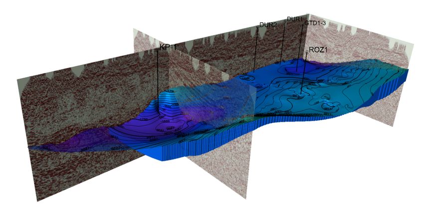
es 2021, 10, x FOR PEER REVIEW 3 of 15
Resources 2021, 10, 31 3 of 15
The main sources of geothermal water in the Western Carpathians are usually linked
with the Middle-Upper Triassic dolomites. Geological processes during the closure of the
Carpathian orogeny uplifted [16],
the Carpathian and eroded
orogeny upliftedthe overlying
[16], and erodedsedimentary rocks sedimentary
the overlying of the Up- rocks of the
per Triassic toUpper Triassic
Cretaceous to Cretaceous
age. They were age. They
eroded towere eroded tolevel.
the dolomite the dolomite
Subsequent level. Subsequent
karstification ofkarstification
the dolomites of the dolomites
created created
the ideal the ideal
aquifer in theaquifer
region.inThe
the region.
heat flow Theisheat
re- flow is related
to the evolution of the Pannonian basin [17–19]. During
lated to the evolution of the Pannonian basin [17–19]. During the Miocene, basin subsid- the Miocene, basin subsidence
accelerated, due to the ascent of asthenolite. The result was
ence accelerated, due to the ascent of asthenolite. The result was earth crust thinning, rift- earth crust thinning, rifting, as
wellformation
ing, as well as the as the formation of the peripheral
of the peripheral basins
basins [20], at the[20], at the northern
northern edge of the edge of the Pannonian
Pan-
basin.individualized
nonian basin. These These individualized sedimentary
sedimentary basins arebasins are considered
considered the most theimportant
most important and the
most suitable
and the most suitable geothermal
geothermal areas inareas in Slovakia
Slovakia with a relatively
with a relatively high heat high heat
flow. flow. Geothermal
Geo-
thermal water in the wells was found at depths ranging from 92 m to 3616 m. Free outflow outflow in the
water in the wells was found at depths ranging from 92 m to 3616 m. Free
wellsfrom
in the wells ranged ranged from
0.1 up to 0.1
100up l/s.toNa-HCO
100 l/s. 3Na-HCO 3 -Cl, Ca-Mg-HCO
-Cl, Ca-Mg-HCO 3, and Na-Cl 3 , and Na-Cl chemical type
chemical
of waters with the TDS value of 0.4–90.0 g · L −1 prevail. The temperatures vary from 20
type of waters with the TDS value of 0.4–90.0 g·L prevail. The temperatures vary from
−1
to 74 ◦ C in 1000 m depth, with an average value of 45 ◦ C. Overall in Slovakia 230.3 MW
20 to 74 °C in 1000 m depth, with an average value of 45 °C. Overall in Slovakia 230.3 MW
and are
and 2000.9 TJ/year 2000.9 TJ/year
utilized [21].are utilized [21].
Geothermal energyGeothermal
for heating energy for heating
is registered in 68islo-
registered in 68
calities (Figure 2a), 39 localities are useable for swimming and bathing, 11 for drying, 6 for11 for drying, 6
localities (Figure 2a), 39 localities are useable for swimming and bathing,
commercial use, for4 commercial
localities foruse, 4 localities
district heating,foranddistrict heating,
only one andfor
locality only
fishone locality for fish farming.
farming.
(a) (b)
Figure 2. geological
Figure 2. Simplified Simplified maps
geological maps (a) Utilization
(a) Utilization of the geothermal
of the geothermal sources in
sources in Slovakia is Slovakia
localizedismainly
local- on the west
ized mainly
side of the territory. on the west
Producing wellsside of the territory.
are situated Producing
in the same aquiferwells
as in are
the situated in the same(b)
Košice depression. aquifer
Košiceasdepression
in lies
the Košice depression. (b) Košice depression lies in the west part of the East Slovakian basin. In
in the west part of the East Slovakian basin. In the geological map are important wells and deep 2D seismic cross-sections
the geological map are important wells and deep 2D seismic cross-sections localization use in the
localization use in the article faults (modified after [21–23]).
article faults (modified after [21–23]).
The article aims to analyze additional parameters, such as tectono-geological limits
The articleinaims to analyzegeothermal
the potential additional area.
parameters, such asof
The processes tectono-geological limits that modified
multiple deformations
in the potentialtectonic
geothermal area. The processes of multiple deformations that modified
and sedimentary structures, had a limiting effect on aquifer spatial distribution,
tectonic and sedimentary
the chemistrystructures,
of fluids had a limiting
(open effect hydraulic
dislocations), on aquiferparameters
spatial distribution,
(subsidence/uplift), the
the chemistry of fluids (open dislocations), hydraulic parameters (subsidence/uplift),
temperature (thermolift), lithology and wells construction. Parameters theof each thermal
temperature (thermolift), lithology and wells construction. Parameters of each thermal
resource have an impact on total initial cost and confirmation of economic re- and technical
source have anfeasibility.
impact on total initial cost and confirmation of economic and technical
feasibility.
2. Materials and Methods
The data set consisted of several types of technical data, which were used to create a
structural model and a 3D model of the aquifers. The 3D model of the southeastern part
of the Kosice basin displays a spatial distribution of the aquifers and overlying Neogene
insulators and spatial thickness transition of the aquifers and their relations to tectonic
structures. Data processing [24], correlation of 2D seismic profiles vs. well data, and
interpretation (Figure 3) have been realized in the Petrel software. The modeling workflow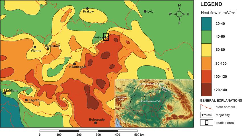
2. Materials and Methods
The data set consisted of several types of technical data, which were used to create a
structural model and a 3D model of the aquifers. The 3D model of the southeastern part
of the Kosice basin displays a spatial distribution of the aquifers and overlying Neogene
Resources 2021, 10, 31 4 of 15
insulators and spatial thickness transition of the aquifers and their relations to tectonic
structures. Data processing [24], correlation of 2D seismic profiles vs. well data, and inter-
pretation (Figure 3) have been realized in the Petrel software. The modeling workflow
includes
includes depth
depth conversion,
conversion, establishing
establishing horizons,
horizons, volume
volumecalculation,
calculation,andandgeometrical
geometrical
modeling.
modeling. Data from the wells that that were
were used
used inin the
the model
model cancan be
be divided
divided into
intothree
three
groups
groups [25–27]. Thefirst
[25–27]. The firstgroup
groupofofwells:
wells:Structural
Structural KP-1,
KP-1, DUR-1,
DUR-1, DUR
DUR -2,-2, ROZ-1,
ROZ-1, andandge-
geothermal key wells, GTD-1, GTD-2, and GTD-3, are situated in the
othermal key wells, GTD-1, GTD-2, and GTD-3, are situated in the Košice depression. TheKošice depression.
The second
second group
group of of wells:
wells: Kosice
Kosice KM-4,Kosice
KM-4, KosiceG5, G5,Kosice
Kosice KM-9,
KM-9, Drienov-2, Bankov-15,
Bankov-15,
Bankov-17
Bankov-17are arelocalized
localized at at
thethe
west edge
west of the
edge of Košice depression.
the Košice The third
depression. The group of wells
third group of
iswells
situated in the in
is situated south Gemeric
the south unit. They
Gemeric are without
unit. They carbonates
are without and dolomites
carbonates and dolomitesin the in
subsurface: Bociar-1,
the subsurface: Cana-6,
Bociar-1, Komarovce-1.
Cana-6, Komarovce-1. Structural andand
Structural lithostratigraphic
lithostratigraphic interpreta-
interpre-
tions come
tations comeoutout
from
from2D2Dseismic cross-sections
seismic cross-sectionsNo.No.700/92, 702/92,
700/92, 702/92, 703/92,
703/92,704/92,
704/92,705/92,
705/92,
and
and 706/92 (Figures 2b and 4). Based on these results, it was possible to distinguishfive
706/92 (Figures 2b and 4). Based on these results, it was possible to distinguish five
following
followingreliably
reliablyindicative
indicativelithostratigraphic
lithostratigraphic interfaces.
interfaces.They
Theyseparate rock
separate complexes
rock complexes of
the different evolution stages of the area:
of the different evolution stages of the area:
1. the basal plane of Mesozoic sequences
1. the basal plane of Mesozoic sequences
2. the interface of Mesozoic top/Karpatian formations
2. the interface of Mesozoic top/Karpatian formations
3. the interface between Karpathian/Early-Middle Badenian formations
3. the interface between Karpathian/Early-Middle Badenian formations
4. Early-Middle Badenian/Late Badenian formations boundary
4. Early-Middle Badenian/Late Badenian formations boundary
5. Late Badenian/Sarmatian formations boundary
5. Late Badenian/Sarmatian formations boundary
Figure3.3.Integrated
Figure Integratedworkflow
workflowdiagram
diagramdivided
dividedinto
intothree
threegroups:
groups:Data
Datacollection
collection(yellow),
(yellow), inter-
interpre-
pretation (orange), and modeling (green).
tation (orange), and modeling (green).
Faultinterpretations
Fault interpretations dodonot
notfall
fallinto
intothe
theimportant
importanttasks
tasksofofgeological
geologicalmodeling.
modeling.At At
thispoint,
this point,wewehave
haveto
toemphasize
emphasizethatthatavailable
availableseismic
seismicdata
databelongs
belongstoto2D2Dand
andnot
notto
toaa3D
3D
category,i.e.,
category, i.e.,they
theyprovide
provideonly
onlylimited
limitedpossibilities
possibilitiesfor
forprecise
precise3D
3Dmodeling.
modeling.TheTheproblem
problem
isis moreover
moreover caused by byrelatively
relativelylarge
large(ca.,
(ca.,5–7 km)
5–7 distances
km) between
distances betweenthe the
2D seismic pro-
2D seismic
profiles. Individual
files. Individual faults
faults could
could changetheir
change theirlength,
length,depth,
depth,and
and direction
direction in the profile,
profile, or
or
they could completely disappear, and new faults could emerge. For the above-mentioned
reasons, the final 3D tectonic model presents a simplified structure of a lesser section of the
area only. Due to the insufficient seismic data quality, fault tectonics is not included in the
rest of the area. The 3D grid processed at the mentioned principles is ready for final 3D
model elaboration and following interpretation steps. For the more precise demonstration
of spatial distribution and changes in the thickness of the model’s interior geostructural
components, the model is sliced.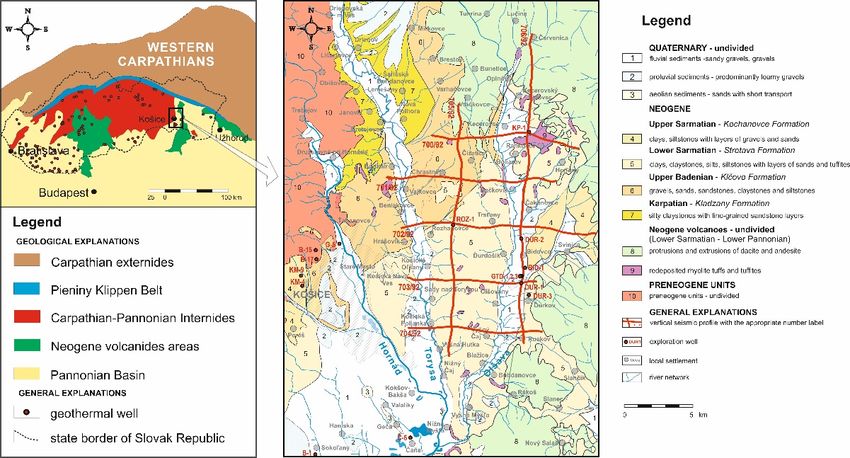
reasons, the final 3D tectonic model presents a simplified structure of a lesser section of
the area only. Due to the insufficient seismic data quality, fault tectonics is not included
in the rest of the area. The 3D grid processed at the mentioned principles is ready for final
3D model elaboration and following interpretation steps. For the more precise demonstra-
Resources 2021, 10, 31 tion of spatial distribution and changes in the thickness of the model’s interior geostruc-
5 of 15
tural components, the model is sliced.
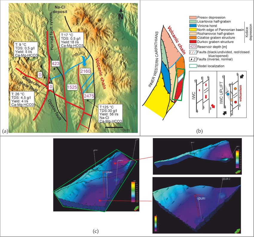
Figure 4. Deep seismic cross-section no. 706/92 oriented in a north–south direction. In the section are interpreted basic
Figure 4. Deep seismic cross-section no. 706/92 oriented in a north–south direction. In the section are interpreted basic
sedimentary formations
sedimentary formations and
and andesite
andesite volcanic
volcanic rocks.
rocks. A
Asignificant
significant antiform
antiform (approximately
(approximately inin the
the middle
middle part)
part) represents
represents
the structural
the structuralboundary
boundarybetween
betweenČižatice
Čižatice and
and Durkov
Durkov depressions.
depressions. TheyThey
are are tectonically
tectonically limited
limited by NE–SW
by NE–SW trending
trending nor-
normal
mal faults
faults (modified
(modified afterafter [28]).
[28]).
3.
3.Results
Results
3.1.Geology
3.1. Geologyand
andHydrogeological
HydrogeologicalConditions
Conditions
TheEast
The EastSlovakian
Slovakianbasin
basinis is filled
filled byby Karpathian/Pannonian
Karpathian/Pannonian volcano-sedimentary
volcano-sedimentary for-
formations
mations andand Quaternary
Quaternary deposits
deposits (Figure
(Figure 5).5).They
Theysubstantially
substantiallydifferdifferinintheir
theirbasement
basement
nature which
nature which hashas aadirect
directconsequence
consequenceonon hydrogeologic
hydrogeologic conditions
conditions of the depressions
of the [29].
depressions
The base of the Košice depression Neogene formations exclusively
[29]. The base of the Košice depression Neogene formations exclusively comprises the In- comprises the Inner West
Carpathian
ner rock complexes.
West Carpathian The footwall
rock complexes. Theof its northern,
footwall of its i.e., the Prešov
northern, part,
i.e., the is formed
Prešov part, by
is
formed by Paleogene sandstone/shale formations. Pre-Tertiary rock sequences of Mts.
Paleogene sandstone/shale formations. Pre-Tertiary rock sequences of the Čierna hora the
(mainlyhora
Čierna Triassic
Mts.dolomites and Paleozoic
(mainly Triassic dolomites cover/crystalline
and Paleozoiccomplexes) are elevated
cover/crystalline at the
complexes)
western margin of the depression [30]. They submerge below the
are elevated at the western margin of the depression [30]. They submerge below the largerlarger part of the Neogene
fill ofofthe
part thedepression.
Neogene fillEspecially a thick dolomite
of the depression. Especially layer posses
a thick very good
dolomite conditions
layer posses very for
water infiltration and groundwater circulation. Paleozoic rock complexes
good conditions for water infiltration and groundwater circulation. Paleozoic rock com- (mostly phyllites)
of the Gemeric
plexes unit [31] form
(mostly phyllites) of thethe main part
Gemeric unitof[31]
the form
depression
the main footwall
part of onthe
thedepression
southwest.
Their low water-saturation capacity is largely restricted to surface
footwall on the southwest. Their low water-saturation capacity is largely restricted to sur- joints and weathering
zone.
face Theand
joints Triassic carbonates
weathering zone.ofThethe Triassic
Čierna hora Mts. Underlying
carbonates of the Čierna thehora
depression on the
Mts. Underly-
western border are located at the geothermally less perspective area. Following actual
ing the depression on the western border are located at the geothermally less perspective
exploration, the most promising part for the economic utilization of geothermal energy
area. Following actual exploration, the most promising part for the economic utilization
seems to be the southeastern part of the depression. In this area, 20 km distant eastward of
of geothermal energy seems to be the southeastern part of the depression. In this area, 20
Košice town, is the most potential Cizatice/Durkov area, where three positive geothermal
km distant eastward of Košice town, is the most potential Cizatice/Durkov area, where
wells, GTD-1, GTD-2, and GTD-3, have been drilled. The wells transected reservoir rocks
three positive geothermal wells, GTD-1, GTD-2, and GTD-3, have been drilled. The wells
(e.g., the Čierna hora Mts. Triassic dolomites) at 2850–3150 m depths. At the GTD-1 well,
transected reservoir rocks (e.g., the Čierna hora Mts. Triassic dolomites) at 2850–3150 m
the water temperature reached 125 ◦ C having 56 L.s−1 discharge overflow.−1 The water
depths. At the GTD-1 well, the water temperature reached 125 °C having 56 L.s discharge
mineralization didn’t exceed 30 g·L−1 containing 96% of CO2 . The water of the GTD-2
overflow. The water mineralization didn’t exceed 30 g·L−1 containing 96% of CO2. The wa-
well, located westwardly from the previous one, achieved 124 ◦ C and the discharge of
ter of the GTD-2 well, located westwardly from the previous one, achieved 124 °C and the
70 Ls−1 . The mineralization doesn´t exceed 28 g·L−1 and 98% CO2 content. The water of
discharge of 70 Ls . The mineralization doesn´t
−1 exceed 28 g·L and 98% CO2 content. The
−1
the geothermal well GTD-3 has reached 126 ◦ C temperature and 150 Ls−1 discharge.
water of the geothermal well GTD-3 has reached 126 °C temperature and 150 Ls−1 dis-
charge.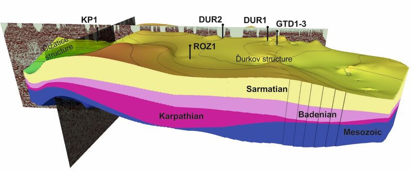
Resources 2021, 10, 31 6 of 15
Resources 2021, 10, x FOR PEER REVIEW 6 of 15
Resources 2021, 10, x FOR PEER REVIEW 6 of 15
Figure
Figure 5.
5. Structural
Structural deep
deep wells
wells with
with representative
representative lithology
lithology and
and stratigraphy
stratigraphy log
log in
in the
the Košice
Košice Depression.
Depression. The
The wells
wells are
are
Figure 5. from
arranged
arranged Structural
fromwest deep
westto wells
toeast.
east. with
InInthe
the representative
same
same direction,
direction, lithologyactivity
geothermal
geothermal and stratigraphy
activity logand
increase,
increase, and in the
the theKošice Depression.
dolomite
dolomite aquifer
aquifer The wells
rapidly
rapidly drops are
drops
down
arranged
down from from
the west to (0
surface east.
m)In to the sameofdirection,
a depth geothermal
2000 m. The activity
aquifer is increase,into
disintegrated andtectonic
the dolomite
blocks aquifer rapidly drops
on the Miocene/Qua-
from the surface (0 m) to a depth of 2000 m. The aquifer is disintegrated into tectonic blocks on the Miocene/Quaternary
down from
ternary the surface
Hornád (0 m)of
fault system toN–S
a depth of 2000
direction m. normal
with The aquifer
fault is disintegrated
activity into
(modified tectonic
after blocks on the Miocene/Qua-
[32–34]).
Hornád fault system of N–S direction with normal fault activity (modified after [32–34]).
ternary Hornád fault system of N–S direction with normal fault activity (modified after [32–34]).
3.2. Structural Model
3.2. Structural
3.2. Structural Model
Model
The spatial and depth extent of the geothermal aquifer in the Košice Basin is limited
The spatial
The spatial and
and depth
depth extent
extent of
of the
the geothermal
geothermal aquifer in
aquifer in the
the Košice
Košice Basin
Basin is
is limited
limited
by the tectonic structure. The basin structure was developed by multiple deformations
by
by the
the tectonic
tectonic structure.
structure. The
The basin
basin structure
structure was
was developed
developed by
by multiple
multiple deformations
deformations
(Figure 6) of the basement underlier and sedimentary filling of the Neogene basin.
(Figure 6)
(Figure 6) of
of the
the basement
basement underlier
underlier and
and sedimentary
sedimentary filling
filling of
of the
the Neogene
Neogene basin.
basin.
Figure 6. Paleostress orientation (red/tension; black/compression arrows) during the East Slovakian basin evolution. De-
Figure 6. Paleostress
formation Paleostress orientation
phases activate
orientation (red/tension;
fault sets
(red/tension;black/compression
with one major system (green arrows)
black/compression row). during
Distinct
arrows) the the
Eastcontrol
tectonic
during Slovakian
East basin
is visible
Slovakian evolution.
on seismic
basin De-
pro-
evolution.
formation
files,
Deformation phases
well cores, activate
and
phases fault
outcrops.
activate setssets
Their
fault with oneon
impact
with major
one system
basin
major (green
basement,
system row). Distinct
subsidence,
(green row). and tectonic
present
Distinct control is visible
morphology
tectonic control on seismic
isisvisible
significant pro-
(mod-
on seismic
files, after
ified wellwell
profiles, cores,
[35]). andand
cores, outcrops. TheirTheir
outcrops. impact on basin
impact basement,
on basin subsidence,
basement, and present
subsidence, morphology
and present is significant
morphology (mod-
is significant
ified after [35]).
(modified after [35]).
As a result of these processes, the aquifer is divided into segments, which run from
As
As aatoresult
the west result of these
the east,
of these processes,
creating a system
processes, theofaquifer
the aquifer is divided
individual
is divided into blocks
structural
into segments,
segments, which
withwhich runverti-
different
run from
from
the
cal west to the
thedepositional
west to the east,
east, creating
depths (Figure
creating aasystem
system
7). At of ofindividual
the individual
same time, structural
individual
structural blocks withdifferent
measurements
blocks with different
also verti-
show
vertical
cal depositional
different depths
permeability
depositional depths of(Figure7).7).
the fault
(Figure Atthe
thesame
system,
At same
which time, individual
affects
time, measurements
the flowmeasurements
individual also show
of thermal groundwater.
also show
different
In
different permeability
the Košice Depression,
permeability of
of the
wefault
the system,
can localize
fault which
system,threewhich affects
affects the
differently flow
flow of
theorientedof thermal
fault groundwater.
systems
thermal NW-SE,
groundwater.
In the Košice Depression, we
N-S, and NE-SW, which differ in age can localize three
of origin,
localize differently
threetheir oriented
activity, impact on
differently fault systems
thesystems
fault NW-SE,
main dolomite
NW-SE,
N-S, and NE-SW, which differ in age of origin,
geothermal aquifer, and impact on underlier morphology. their activity, impact on the main dolomite
geothermal aquifer, and impact on underlier morphology. morphology.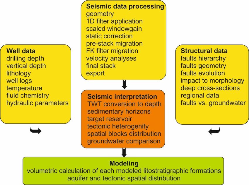
Resources 2021, 10, 31 7 of 15
Resources 2021, 10, x FOR PEER REVIEW 7 of 15
Figure
Figure 7.
7. Block
Blockstructure
structuredistribution
distributionbounded
bounded by by
three basic
three systems
basic of NW–SE,
systems of NW–SE, N–S,N–S,
and NE–SW
and NE–SWdirected faults in
directed the
faults
territory of the Košice depression. (a) Interaction between morphology and tectonics is largely
in the territory of the Košice depression. (a) Interaction between morphology and tectonics is largely influenced by influenced by Mio-
cene/Quaternary tectonics. The depth of the aquifer gradually increases from west to east to a depth of 2475 m at a distance
Miocene/Quaternary tectonics. The depth of the aquifer gradually increases from west to east to a depth of 2475 m at
of 20 km. (b) Sketch of two important deformation stages of tectonic structure development. The period of Upper Badenian
a distance of 20 km. (b) Sketch of two important deformation stages of tectonic structure development. The period of
was characterized by the delimitation of crust and its disintegration on N–S trending faults, while their asymmetric sub-
Upper Badenian
sidence caused the was characterized
formation by thedips
of sinistral delimitation of crust and
with subsequent its disintegration
formation on N–S trending
of individualized faults,
shear basins. Thewhile their
Miocene
asymmetric subsidence caused the formation of sinistral dips with subsequent formation of individualized
uplift of the Inner Western Carpathians (IWC) was compensated at the edge with the East Slovakian basin by forming shear basins.
The Mioceneshear
asymmetric upliftbends,
of the Inner
whileWestern Carpathians
externally from this (IWC)
zone, was
this compensated at the edge with
uplift was compensated the East
by oblique Slovakian
drops on thebasin by
SE. (c)
Block
formingmodels of the Middle
asymmetric Triassic
shear bends, dolomites
while underlying
externally from thisthe Košice
zone, Basin was
this uplift indicate significantbyirregularity
compensated andon
oblique drops very
thesig-
SE.
nificant
(c) Blocktectonic
modelslimitation. Tectonic
of the Middle boundaries
Triassic dolomites have differentthe
underlying properties from indicate
Košice Basin the viewpoint of permeability
significant irregularity(modified
and very
after [23]). tectonic limitation. Tectonic boundaries have different properties from the viewpoint of permeability (modified
significant
after [23]).
NW–SE fault system is parallel with the direction of major tectonic units of the West-
ern Carpathians.
NW–SE fault Margecany
system is shear zone
parallel is a the
with pre-Mesozoic tectonic
direction of major structure that tectoni-
tectonic units of the
cally divides
Western the Gemeric
Carpathians. unit (phyllites/low
Margecany shear zonepermeability) and the
is a pre-Mesozoic Veporic
tectonic unit (dolo-
structure that
mites/high
tectonicallypermeability). The morphology
divides the Gemeric and the fault
unit (phyllites/low rocks of theand
permeability) zone areVeporic
the on the unit
sur-
(dolomites/high
face permeability).
best visible between The and
the Košice morphology and thetowns.
the Margecany fault rocks of the zone
The activity of theare on
zone
the surface
has bestcharacter
polystage visible between
and wastheformed
Košice and the Margecany
during the Alpine towns. The activity
Cretaceous of the
North–South
zone has polystage
shortening character
of the Central and was
Western formed during
Carpathians. The the Alpine
zone Cretaceous several
was reactivated North–South
times
during the Cretaceous-Neogene period. The zone is tens of meters wide on the surface.
Resources 2021, 10, 31                                                                                              8 of 15

                         shortening of the Central Western Carpathians. The zone was reactivated several times
                         during the Cretaceous-Neogene period. The zone is tens of meters wide on the surface.
                         Towards the depth, the zone is lesser inclined to a subhorizontal position. Shear zone
                         segments rocks of the crystalline complexes, as well as the rocks of the cover formations.
                         Typical fault rocks are mylonites of the crystalline gneisses, mylonites of the Carboniferous
                         and Permian meta-sediments, and mylonites of the Triassic quartzites. Mylonites have
                         strong foliation and penetrative subhorizontal stretching lineation of the NW–SE direction.
                         There are also occurring rauwackes of the Mesozoic carbonates. Therefore, this zone
                         is the so-called “main limiting parameter”, which tectonically delimits the potentially
                         usable area from the south. Parallel with this shear zone, the dislocations of the lower
                         level were developed. Their multi-deformation history points out the structural diversity
                         depending on paleo-stress conditions. The sigmoidal transpress bend of the Vinicna horst
                         was developed at these fractures. Positive structures and local declines compensate the
                         Miocene subsidence of the basin, e.g., subsidence of the Košice depression, rating from
                         –285 m to –310 m during the post-Middle Miocene to Holocene period [29].
                              The N-S trending Hornád fault zone controls geomorphology of the depression. Dur-
                         ing the Paleogene/Quaternary period, the faults of the zone divided the Košice depression
                         into individual sub-depressions with huge tectonic subsiding from west to east. Mostly
                         eastwards (60–85◦ ) inclined faults, forming 3 to 5 km wide zone, practically check the
                         shape and filling of the depression, including geothermal carbonate reservoir and their
                         underlying rock complexes. A relatively massive normal faulting represented a total rate
                         of subsidence 2100 m at a distance of 20 km. The faults substantially influence the current
                         submersion depth of these initially slowly eastwards inclined Miocene also formations. The
                         polystage history of the fault is closely related to ESB opening during the Miocene period.
                         According to structural research, it is possible to track deformation stages on the fault.
                              Huge subsidence of the ESB during the Early Miocene created a system of N–S de-
                         pressions. Middle Miocene core delamination had an impact on the fault too. Asymmetric
                         subsidence and plate rotation effect [36,37] caused sinistral shear movements with high
                         intensity at the west ESB rim [38]. The basin breakdown is possible to correlate with
                         horizons in the seismic cross-sections (Figures 4 and 5) and with subdivision into blocks,
                         horsts, and depressions. The fault is filled with cataclastic surrounding sediments (mainly
                         shales) with limited permeability.
                              Moderately (45–60◦ ) mostly to the SE dipped NE-SW faults, are related with depres-
                         sion forming in the transtensional tectonic regime. The faults separate the depression
                         basement into individual blocks. Tension tectonic has a positive impact on permeability
                         and fluid flow. The same structure separates the northern Čižatice depression from the
                         southern Ďurkov depression. Groundwater migration from the center of the basin towards
                         the western edge at the contact with the Hornád fault system in the Košice area is likely
                         occurring at these faults. As a result, disproportionally high groundwater temperatures are
                         observed towards the western edge of the basin. Therefore, these are “key fault structures”
                         that enabled the flow of overheated groundwater in the Košice Depression (Table 1).

                         Table 1. Basic fault parameters with different impacts on permeability and surface morphology.

                               Faults            Rank                 Sense             Permeability      Morphology
                               NW-SE             I., III.     Inverse, shear, normal       closed         asymmetric
                                N-S                 II.           shear, normal,           closed       horst/depressions
                               NE-SW             III., IV.           Normal                opened               -

                              Based on the results of the structural model in the southeastern part of Košice Depres-
                         sion, the so-called Ďurkov/Čižatice geothermal area, the thickness, and distribution of
                         sedimentary packets, which are also considered as potential aquifers, has been modeled.
                         The 3 D model is bounded on the east by the Sarmatian neovolcanic of Slanské vrchy Mts.,
                         which in places laterally extend into the filling of the sedimentary basin. The western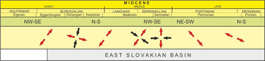
Resources 2021, 10, x FOR PEER REVIEW 9 of 15
Resources 2021, 10, 31 9 of 15
boundary of the model is represented by the N-S fault line, which is part of the Hornád
fault zone. At these faults, the depth of the underlier reaches the greatest depths in the
boundary of the model is represented by the N-S fault line, which is part of the Hornád
Košice Depression, which was verified by several wells. The Margecany shear zone bor-
fault zone. At these faults, the depth of the underlier reaches the greatest depths in the
ders the model from the south and the NE-SW fault from the north.
Košice Depression, which was verified by several wells. The Margecany shear zone borders
In the seismic profiles, five lithostratigraphic boundaries are interpreted. Seismic re-
the model from the south and the NE-SW fault from the north.
flexes of the middle part of the profile indicate a pronounced pre-tertiary basement eleva-
In the seismic profiles, five lithostratigraphic boundaries are interpreted. Seismic
tion, reflecting probably an uplift effect of the Sarmatian neovolcanites. Steeply dipped
reflexes of the middle part of the profile indicate a pronounced pre-tertiary basement
normal faults and/or oblique-slip faults detected within the profile reduce the Miocene
elevation, reflecting probably an uplift effect of the Sarmatian neovolcanites. Steeply
sequences
dipped and markedly
normal cut the
faults and/or Mesozoicfaults
oblique-slip formations.
detectedIn within
the longtheaxis of the
profile model
reduce theis
possible to identify flexural bend separating Čižatice and Ďurkov structure.
Miocene sequences and markedly cut the Mesozoic formations. In the long axis of the More infor-
mationisabout
model the to
possible Miocene
identifybasement composition
flexural bend andČižatice
separating deformation nature structure.
and Ďurkov provide the KP-
More
1, DUR-1, and DUR-2 wells. The last well penetrate heavily crushed
information about the Miocene basement composition and deformation nature provide Middle/Late Triassic
dolomites
the [39]. Penetrating
KP-1, DUR-1, and DUR-2 of the The
wells. Late/Middle Triassic carbonates
last well penetrate in theMiddle/Late
heavily crushed DUR-1 well
ceased at
Triassic 3200 m depth.
dolomites The top section
[39]. Penetrating ofLate/Middle
of the the carbonates, whichcarbonates
Triassic are underlying
in thethe Neo-
DUR-1
gene successions, comprises light grey compact dolomite shales containing
well ceased at 3200 m depth. The top section of the carbonates, which are underlying the dynamo-met-
amorphicsuccessions,
Neogene exsolutions comprises
of calcite veins. Darkcompact
light grey grey clay/shale
dolomitelayers
shalesamong dolomites
containing dynamo-ap-
pear, namely, at 2682–2753 m depth interval. From ca. 2750 m depth dolomites
metamorphic exsolutions of calcite veins. Dark grey clay/shale layers among dolomites containing
an increased
appear, namely, CaCO 3 (up to 45%)
at 2682–2753 [40].interval. From ca. 2750 m depth dolomites containing
m depth
The modeling
an increased CaCO3 of evaluated
(up seismic/well data allows specifying four lithostructural
to 45%) [40].
geothermal water aquifers
The modeling (Figure
of evaluated 8) limited by
seismic/well theallows
data over/underlying
specifying bedding planes.
four lithostructural
geothermal water aquifers (Figure 8) limited by the over/underlying bedding planes.
Figure
Figure8. 3D geothermal
8. 3D geothermalmodel
modelofofthe the major
major lithological
lithological formations
formations participated
participated in Košice
in the the Košice Depression
Depression geological
geological struc-
structure. The dolomites (blue) represent the main aquifer of the geothermal structure,
ture. The dolomites (blue) represent the main aquifer of the geothermal structure, which has an which has an asymmetric shape
shape ininits
its
N–Sdirection.
N–S direction.InInthe
themodel
modelis is a nice
a nice visible
visible flexural
flexural boundary
boundary between
between Čizatice
Čizatice and Ďurkov
and Ďurkov structures
structures (modified
(modified after
after [29]).
[29]).
The first aquifer (AQ1) body forms the Mesozoic sequence of the Čierna hora Mts.
VeporicTheunit.
firstThe deepest
aquifer partbody
(AQ1) of theforms
Mesozoic pile, i. e. the
the Mesozoic basal aquifer
sequence of the plane
Čierna(marked in
hora Mts.
violet
Veporiccolor in Figure
unit. 8), reaches
The deepest part depth
of the 2000 m to 2600
Mesozoic pile, m,i. e.while a depth
the basal of itsplane
aquifer overlying pre-
(marked
Neogene interface
in violet color varies8),
in Figure from 1250 m
reaches to 1380
depth 2000m.mThe aquifer
to 2600 sole depth
m, while a depthdifferences proba-
of its overlying
bly indicate topographical
pre-Neogene interface varieseffects
fromof pre-Neogene
1250 m to 1380 denudation and/orsole
m. The aquifer syn-postsedimentary
depth differences
tectonic
probably processes. At the central part
indicate topographical of the
effects modeled section,
of pre-Neogene an outstanding
denudation and/or (blue-colored
syn-postsedi-
at Figure 9) elevation extends. The elevation separates the Ďurkov
mentary tectonic processes. At the central part of the modeled section, an outstanding area depression of the
SE edge of the section from the Čižatice graben structure developed
(blue-colored at Figure 9) elevation extends. The elevation separates the Ďurkov area de-at the western section
margin.
pressionBoth
of theof SE
theedge
graben structures
of the section are
fromreflecting probably
the Čižatice NE-SW
graben normal
structure faulting.atThe
developed the
Ďurkov graben structure is not as large as the previous surface,
western section margin. Both of the graben structures are reflecting probably NE-SW but the depression in nor-
the
Čižatice area isThe
mal faulting. stillĎurkov
very outstanding. It is because
graben structure is not of
as the
largeincreasing activity surface,
as the previous of the Miocene
but the
N-S or NE-SW faults. These two surfaces delimitate Triassic carbonate
depression in the Čižatice area is still very outstanding. It is because of the increasingrocks, and variability
in topography and thickness can be assumed. Only two wells from the plotted ones, i.e.,
KP-1 and ROZ-1, penetrate the Mesozoic pile sole. The overlying plane of the aquiferactivity of the Miocene N-S or NE-SW faults. These two surfaces delimitate Triassic car-
Resources 2021, 10, 31
bonate rocks, and variability in topography and thickness can be assumed. Only two wells 10 of 15
from the plotted ones, i.e., KP-1 and ROZ-1, penetrate the Mesozoic pile sole. The overly-
ing plane of the aquifer elevation shows an uneven topography. Its deepest level reaches
from 1800 m to ca. 2270 m, while the highest one from 800 m to 85 m only. Larger altitude
elevation shows
differences, an unevento
in comparison topography. Its deepest
the Mesozoic levelaquifer
formations reachessole,
fromseemingly
1800 m to reflect
ca. 2270 m,
the
while the highest
post-Sarmatian one
fault from 800
activity andmdistinctly
to 85 m only. Larger
higher altitudecompetencies
deformation differences, inofcomparison
overlying
to the Mesozoic
Neogene formations
formations as well.aquifer sole, seemingly reflect the post-Sarmatian fault activity
and distinctly higher deformation competencies of overlying Neogene formations as well.
Figure 9. 3D model of the Middle Triassic buried dolomites under Košice depression. The thickness and inclination changes
Figure 9. 3D model
are influenced of thetectonics,
by fracture Middle Triassic
which isburied dolomites
an important under phenomenon
structural Košice depression. The thickness
underlying the aquifer.and inclination
changes are influenced by fracture tectonics, which is an important structural phenomenon underlying the aquifer.
The second (AQ2) aquifer body form Karpathian clastic sediments (mainly conglom-
The
erates andsecond (AQ2) aquifer
sandstones). body form
This Neogene basalKarpathian
formationclastic sediments
lies directly on the (mainly
Mesozoic conglom-
aquifer,
erates and sandstones). This Neogene basal formation lies directly
following in this manner topography of Mesozoic formations. The Karpathian deposits on the Mesozoic aqui-
fer, following in this manner topography of Mesozoic formations.
are conformably overlain by Lower/Middle Badenian fine-grained clastic sediments and The Karpathian depos-
its are conformably
evaporite sediments.overlain by Lower/Middle
The topography Badenian fine-grained
of this lithostratigraphic interface is clastic
not assediments
rugged as
and evaporite
in the previouslysediments.
discussed The topography
cases. of thisinlithostratigraphic
The variation depth shows ca. interface is not as220
260 ms (approx. rug-
m).
ged
Theassurface
in the previously
deepest part discussed
reaches cases.
1550 msThe(ca.variation
1850 m), in depth
and the shows ca. 260
top-level ms (approx.
reaches 600 ms
220 m). The
(approx. 570surface
m). The deepest partofreaches
intensity 1550decreases,
N-S faults ms (ca. 1850 m),NE-SW
while and thefaults
top-level reaches
are still very
600 ms (approx. 570 m). The intensity of N-S faults decreases, while NE-SW faults are still
outstanding.
very outstanding.
The third (AQ3) aquifer body is sandwiched between the Lower/Middle Badenian
andTheUpper Badenian
third boundaries.
(AQ3) aquifer bodyItishas a moderatebetween
sandwiched topography, but a distinct depression
the Lower/Middle Badenian
in the
and western
Upper part ofboundaries.
Badenian the section surface
It has aachieves
moderate 1080 m amplitude.
topography, but aThe maximal
distinct depth of
depression
inthe
thedepression
western part reaches
of theca.1530
section m,surface
while its top point
achieves is located
1080 at ca. 450
m amplitude. The m maximal
depth. Whereas,
depth
ofanthe
activity of the NE-SW
depression reaches faults
ca.1530fades
m, out
whilein the depression,
its top point is normal
locatedfaulting
at ca. 450at the NW-SE
m depth.
faults is still
Whereas, progressive.
an activity of the NE-SW faults fades out in the depression, normal faulting at
the NW-SE faultsBadenian/Sarmatian
The Upper is still progressive. bedding plane terminates the fourth (AQ4) aquifer
body.TheIt Upper
forms the top surface of the model
Badenian/Sarmatian bedding with
planea moderate
terminates topography
the fourthof(AQ4)the boundary
aquifer
planeItorforms
body. its outstanding depression
the top surface of thereaching
model with ca. 910 m depth.topography
a moderate The Sarmatian volcanoclastic
of the boundary
sediments
plane of the modeled
or its outstanding area outcrops
depression to the
reaching ca. surface.
910 m depth. The Sarmatian volcanoclas-
tic sediments of the modeled area outcrops to the surface.calculation (the model comes out
The following indicative/proportional volumetric
fromThe2D)following
of the individual lithostratigraphic
indicative/proportional horizons of
volumetric the Košice(the
calculation depression
model comes formsoutone
of the modeled outputs (Table 2). As it results from the cubature
from 2D) of the individual lithostratigraphic horizons of the Košice depression forms one of the formations, the
Karpathian aquifer possesses the highest capacity for geothermal
of the modeled outputs (Table 2). As it results from the cubature of the formations, the water accumulations.
Regarding volumetrically
Karpathian aquifer possesses the second aquifer,
the highest it is necessary
capacity to mention,
for geothermal water that only Mesozoic
accumulations.
sequences volumetrically
comprising ca. 40.6 3
km of calculated
Regarding the second aquifer, it volume, couldtobemention,
is necessary effectivethat
for the
only discussed
Meso-
purposes. Such volumes are not present throughout the Košice depression.
zoic sequences comprising ca. 40.6 km of calculated volume, could be effective for the
3 The thicknesses
of dolomites in the Ďurkov/Čižatice area are many times thicker, which is related to their
tectonic accumulation (duplexes) as a consequence of the uplift and unroofing of Čierna
Hora Mts.Resources 2021, 10, 31 11 of 15
Table 2. Results of volumetric calculation of each modeled lithostratigraphic formation.
Bulk Volume Percentage
Body
(km3 ) (%)
Sarmatian 73,457 35.8
Badenian 34,674 16.9
Karpathian 56,285 27.5
Mesozoic 40,618 19.8
4. Discussion
The creation of economically perspective geothermal water reservoirs at geological
conditions of the East Slovakian basin (ESB) closely depends on a sufficient geothermal
flow and a presence of compositionally/volumetrically adequate aquifers. Both are present
in the western part of the ESB, especially the southeastern section of the Košice subbasin,
more precisely in the Čižatice/Ďurkov structure.
Presented values reflect main rock formations data collected largely from the south-
eastern margin of the Košice depression. They could be significantly influenced by initial
compositional irregularities and the tectonic impact as well. The dolomitic aquifer (AQ1) of
the Middle Triassic Period with underlying Verfenian shales, ± quartzites, Permian cover
formation, and crystalline basement rocks (as has been confirmed by mentioned KP-1 well)
belongs to the Čierna hora Veporic unit [41]. The dolomitic complex shows the variable
thickness and lateral development throughout the unit [42]. The thickness irregularities
are related to duplexes of the Triassic dolomites observed in the surface and also in drill
cores. At such conditions, a vertical duplication of the dolomitic sequences is multiplying
their reservoir capacity. The thickness of the dolomite aquifer is variable. In the western
edge at the contact with the basement, the Middle Traissic dolomite complex thickness is
185 m, towards to east it grows up to 1060 m.
The thickness of sedimentary layers is a key factor in terms of total groundwater
reserves, but also for the calculation of the thermal gradient.
An average thermal gradient of the depression sedimentary fill varies from 36.5 to
50.3 ◦ C/km or between 25.0–32.3 ◦ C/km in pre–Tertiary rock formations, respectively [43].
The relatively high thermal gradient in the Neogene sequences relates to their lower
thermal conductivity. The geothermal gradient generally increases towards the Pannonian
basin (i.e., in the south direction), due to a substantially larger overheating of the thinning
Earth crust. A tectonic brecciation and the hot water inflow at the faults are the other
reasons for higher geothermal gradient raising within the Neogene sequences. At depths
of 500–4000 m, i.e., at the depths of a presumable geothermal water aquifers location, the
temperature ranges from 27–182 ◦ C [44]. Thermal conductivity of particular lithotypes
recorded regional and vertical characteristics of horizons. Thermal conductivity varies from
1.6 (W/mK) for coarse-grained formations and evaporites, 1.8 (W/mK) for fine-grained
lithotypes, and 3.1 (W/mK) for carbonates in the Western Carpathians. The andesites
observed in the SE part of the structure have defined thermal conductivity of 2.1 (W/mK).
Hereby, mean geothermal values are used, and the possible impact of horizon thickness
and depth of its top is limited to a minimum. Analysis of the sedimentary fill in the wells
confirms a rather smaller thermal conductivity growth in the depth. While Sarmatian
(AQ4) sediments show lower (i.e., 2.10 W/mK) thermal conductivity, the conductivity of
Badenian and Karpatian (AQ3,AQ2) sediments is somewhat higher, i.e., 2.09 W/mK to
2.19 W/mK, respectively. The conductivity of Paleogene sandy/clay sediments shows a
characteristic value of 2.31 W/mK. An average thermal conductivity of the Tertiary rocks
varies about 2.05 ± 0.25 W/mK (Table 3), while constant Mesozoic carbonate rocks display
3.62 W/mK [39]. The highest thermal flow values (i.e., 100–110 mW/m2 ) of the area have
been detected at the foothills of the Slanské vrchy Mts. neovolcanic territory. In the central
part of the Košice depression, typical values range between 85–95 mW/m2 , while in itsResources 2021, 10, 31 12 of 15
western part, they vary at the 80–85 mW/m2 interval. The average value of the Košice
depression thermal flow reaches 94.9 ± 10.5 mW/m2 .
Table 3. Geothermal data summary.
Thermal
Thermal Conductivity
Stratigraphy Lithology Gradient
◦ C/km W/mK
claystones
Sarmatian 2.10
sandstones
NEOGENE av.
Badenian claystones 38.1–51.4 2.10 2.05 ± 0.25
(23–2.5 Ma)
Karpathian conglomerates 2.19
dolomites
MESOZOIC (251–66 Ma) 22.4–30.6 3.62
limestones
The groundwater geochemical analyzes from Košice depression show significant
differences. Waters of the Ca-Mg-HCO3 type with a hydrochemical coefficient Cl/Na = 0.75
predominate. These waters have origin in the dolomites of the Mesozoic unit of Čierna
Hora Mts. The structure of Čižatice/Ďurkov is dominated by groundwater with NaCl
content with a low proportion of Na-HCO3 . From the origin point of view, these waters
formed by the infiltration of probably meteoric/marine (subsequently marinogenic) water
through Neogene formations (also salt marine sediments of Karpathian) into the Mesozoic
collector [45,46]. By dissolving salts from salt formations, the waters contain small amounts
of Br and have a Cl/Br ratio greater than 1000. It is a specific-polygenic type of geothermal
water created when sea (marinogenic) water dissolves saline formations of the Karpathian.
Their origin is probably in the area north of the Čižatice structure at the northern edge of
the Košice Basin. The source may be in the evaporites of the Sol’ná Baňa Formation. The
water solutions from them infiltrate through the NE-SW faults towards the south. On the
contrary, their lateral distribution is limited by the sealing properties of the N-S Hornád
fault system, and therefore, this type of water reaches the western edge of the basin.
The exploitation of geothermal energy in practice is primarily a source of possibilities.
Even if a hyperthermal structure is missing slightly lower tempered geothermal water
of this area is technologically utilizable for power generation and/or heating of Kosice
town [39], as it is known from other world countries. For example, ORC binary power
plants are designed for temperatures ranging from 45 ◦ C (Alaska) to 225 ◦ C (Hawaii) and
are built in a variety of sizes [47–49]. For comparison, the Turkey government in 2015
build a low-temperature geothermal powerplant Tosunlar 1, with an output steam/brine
of 105 ◦ C and gross electrical generation of 3878 kW [50]. Residual heat can be used for
secondary purposes, e.g., for tourism development, agricultural or industrial production.
5. Conclusions
Geothermal waters in the western edge of the East Slovakian basin saturate the
Mesozoic karstified limestones and dolomites with fissure and karstic permeability.
The thickness of the Mesozoic aquifer is increasing from the west (185 m) to the east
(1060 m or more). The changes of thickness relate to the tectonic thickening of layers
as a consequence of the uplift of the basement units on the western edge of the East
Slovakian basin.
The aquifer depth increase significantly from the west (0 m) to the east (2475 m) on a
short distance of 20 km. The entire original horizon is subdivided into tectonic blocks
with individual depth and lateral rate by the “domino” effect. The vertical subsidence
of the tectonic blocks reaches 1200 m.
The process of individualization of the tectonic blocks was successive. First, existing
NW-SE and N-S pre-Miocene structures were preferred. Later, evolutionary younger
dislocations and joints of NE-SW direction were active.You can also read