CULTURAL HERITAGE ASSESSMENT REPORT - 292 Dundas Street East, Waterdown (Maple Lawn) City of Hamilton
←
→
Page content transcription
If your browser does not render page correctly, please read the page content below
CULTURAL HERITAGE ASSESSMENT REPORT

      292 Dundas Street East, Waterdown
                (Maple Lawn)
              City of Hamilton

Prepared by Lisa Oversby, Assistant Cultural Heritage Planner
       and Miranda Brunton, Cultural Heritage Planner
with assistance from Alissa Golden, Heritage Project Specialist

     Development Planning, Heritage and Design Section
                      Planning Division
      Planning and Economic Development Department
                       City of Hamilton
           July 16, 2020 (DRAFT FOR COMMENT)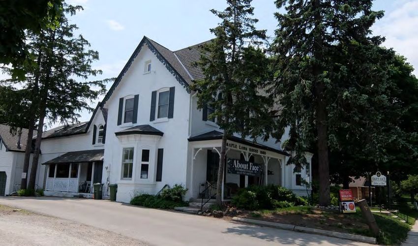
CULTURAL HERITAGE ASSESSMENT REPORT: A READER’S GUIDE

This cultural heritage assessment report is prepared as part of a standard process that
assists in determining the cultural heritage value of properties and their prospective
merit for protection, including designation and/or a heritage conservation easement
agreement, under the Ontario Heritage Act.

This report is divided into six sections:

Section 1 comprises an introduction including a description of the property location.

Section 2, Physiographic Context, contains a description of the physiographic region in
which the subject property is located.

Section 3, Settlement Context, contains a description of the broad historical
development of the settlement in which the subject property is located as well as the
development of the subject property itself. A range of secondary sources such as local
histories and a variety of historical and topographical maps are used to determine
settlement history.

Section 4, Property Description, describes the subject property’s key heritage
characteristics that provide the base information to be used in Section 5.

Section 5, Cultural Heritage Evaluation, comprises a detailed evaluation of the subject
property using the three sets of evaluation criteria: archaeology; built heritage; and,
cultural heritage landscapes.

Section 6, Cultural Heritage Value: Conclusions and Recommendations, comprises a
brief summary of the Cultural Heritage Evaluation and provides a list of those criteria
that have been satisfied in determining cultural heritage value, as well as determining
compliance with Ontario Regulation 9/06. It also contains a recommendation as to
whether or not the subject property should be protected under the Ontario Heritage Act
through designation and/or a heritage conservation easement agreement, including a
Statement of Cultural Heritage Value or Interest and Description of Heritage Attributes.
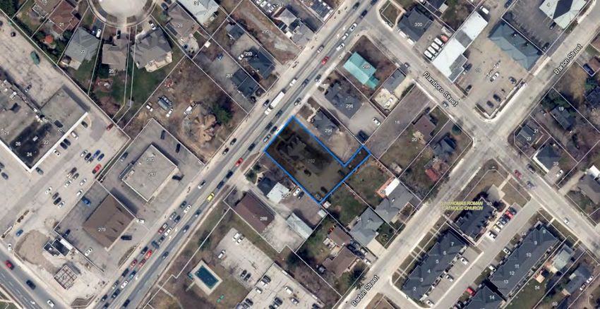
Table of Contents

1. Introduction ............................................................................................................. 7
     1.1 Waterdown Village Built Heritage Inventory Project ........................................... 7
     1.2 Potential Designation and Next Steps ................................................................ 7
     1.3 Property Location ............................................................................................... 7
2. Physiographic Context ........................................................................................... 8
3. Settlement Context ................................................................................................. 9
     3.1 Indigenous Settlement ....................................................................................... 9
     3.2 Euro Canadian Settlement ............................................................................... 10
     3.3 Contemporary Context ..................................................................................... 15
4. Property Description ............................................................................................ 18
     4.1 Evolution of the Buildings and Landscape ....................................................... 18
     4.2 Building Description ......................................................................................... 21
5. Cultural Heritage Evaluation ................................................................................ 24
     5.1 Archaeology ..................................................................................................... 24
           5.1.1 Archaeological Potential ......................................................................... 24
     5.2 Built Heritage.................................................................................................... 25
           5.2.1 Historical Associations ........................................................................... 25
           5.2.2 Architecture and Design ......................................................................... 26
           5.2.3 Integrity .................................................................................................. 27
           5.2.4 Environmental Context ........................................................................... 27
           5.2.5 Social Value ........................................................................................... 28
     5.3 Cultural Heritage Landscapes .......................................................................... 28
6. Cultural Heritage Value: Conclusions and Recommendations ........................ 30
     6.1 Conclusions...................................................................................................... 30
     6.2 Compliance with Ontario Regulation 9/06: Criteria for Determining Cultural
     Heritage Value or Interest ....................................................................................... 30
           6.2.1 Design / Physical Value .......................................................................... 31
           6.2.2 Historical / Associative Value ................................................................. 32
           6.2.3 Contextual Value .................................................................................... 32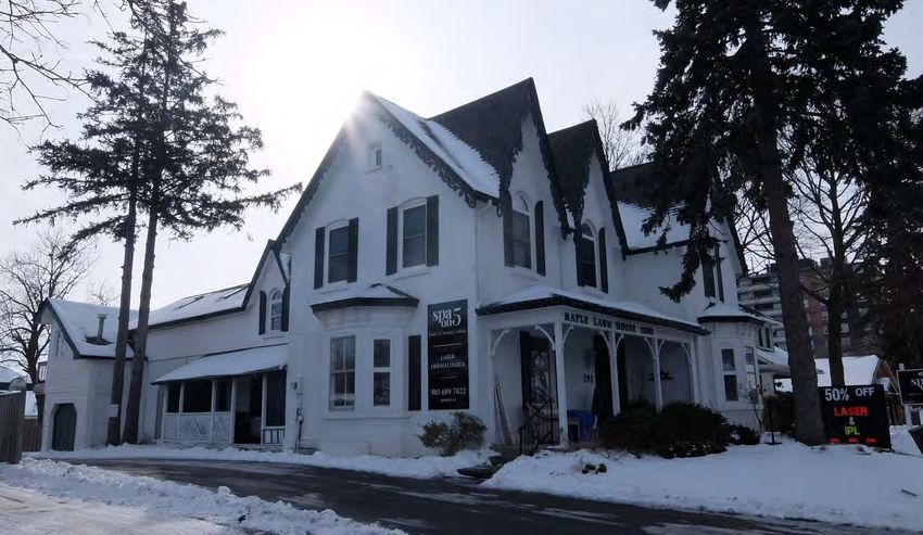
6.3 Recommendation ............................................................................................. 32
Bibliography ................................................................................................................ 35
Appendix A: Location Map ......................................................................................... 38
Appendix B: Photographs .......................................................................................... 39
Appendix C: Historical Images .................................................................................. 47
Appendix D: Plans and Mapping................................................................................ 57
Appendix E: Ownership History................................................................................. 61
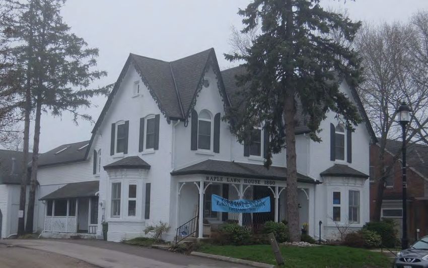
Table of Figures

Figure 1: The physiographic regions of Southern Ontario from Chapman and Putnam's
The Physiography of Southern Ontario, 1984, Page 113 (Approximate location of
Waterdown identified by red circle) ................................................................................. 8
Figure 2: Dish With One Spoon Wampum Belt Reproduction (utoronto.ca) .................... 9
Figure 3: Geneva concessions as illustrated on a map of the treaties with the
Indigenous from the Mississaugas of the Credit First Nation webpage ......................... 11
Figure 4: Excerpt from the Waterdown 1937 Fire Insurance Plan depicting the location
of the Waterdown Review Printing building on Flamboro Street (highlighted in red), to
the southeast of 292 Dundas Street East (shown as #25 Dundas Street) ..................... 13
Figures 5 and 6 (l to r): Waterdown Review, 30 Main Street North, 1976; An artist's
rendering of the Flamborough Review located at 30 Main Street North; Source:
Hamilton Public Library, photograph by JBH; Flamborough Review article "Flamborough
Review Relocating Office,” January 16, 2018 ............................................................... 14
Figure 7: South side of Dundas Street looking west from 290 Dundas Street (June
2018) ............................................................................................................................. 16
Figure 8: Twentieth-century commercial buildings west and north of 292 Dundas Street
East, looking northwest towards Hamilton Street (June 2018) ...................................... 16
Figure 9: South side of Dundas Street looking east from 290 Dundas Street (June 2018)
...................................................................................................................................... 17
Figure 10: South side of Dundas Street looking East from Hamilton Street showing the
tree canopy, 292 Dundas Street East at the middle right (June 2018) .......................... 17
Figure 11: 292 Dundas Street East, highlighted in grey, City of Hamilton GISnet, 201918
Figure 12: 292 Dundas Street East, Waterdown, circa 1888; Source: Flamborough
Archives, BW 2836 ........................................................................................................ 19
Figure 13: 292 Dundas Street East, Waterdown, January 2020 ................................... 19
Figure 14: Insurance Plan of the Village of Waterdown, ON, May 1939, Excerpt of Sheet
1 (Existing property boundary of 292 Dundas Street East highlighted in red) ............... 20
Figure 15: Aerial view of 292 Dundas Street East, City of Hamilton GISnet, 2019
(Excerpt showing the T-shaped front portion in red, the one-and-a-half storey rear wing
in yellow and the former carriage house in light blue) ................................................... 23
Figure 16: Map of subject property and surrounding area, City of Hamilton GISNet ..... 38
Figure 17: Aerial view of subject property and immediate vicinity City of Hamilton
GISNet (2019) ............................................................................................................... 38
1.         Introduction
This cultural heritage assessment report examines the cultural heritage value or interest
of the property located at 292 Dundas Street East in Waterdown, known historically as
the Maple Lawn House, The Gables and Witheridge. The property is comprised of a
two-storey brick building originally constructed circa 1887 as a residence, which has
been adaptively reused for commercial purposes.
City Council considered a request to designate the subject property from the local Ward
Councillor on August 16, 2019, resulting in the listing of 292 Dundas Street East on the
City’s Municipal Heritage Register and directing staff to add the property to the City’s
designation work plan as an immediate priority (Planning Committee Report 19-012).

1.1        Waterdown Village Built Heritage Inventory Project
This assessment is conducted in conjunction with the Waterdown Village Built Heritage
Inventory Project, the latest phase in the City of Hamilton’s ongoing Built Heritage
Inventory Process. Previous phases of this process include the Downtown Built
Heritage Inventory Project (PED14191), completed in 2014, and the Durand
Neighbourhood Built Heritage Inventory (PED17092), completed in 2017.
The primary goal of this inventory project is to evaluate each property within the
Waterdown Village study area to determine its heritage value or interest. This evaluation
will guide future cultural heritage decision making and policy creation.

1.2        Potential Designation and Next Steps
The subject property has been identified as a property of potentially significant cultural
heritage value. As a result, extensive research has been conducted to determine the
cultural heritage value of the property, which is outlined in this document, and could
result in a recommendation for designation under Part IV of the Ontario Heritage Act.

1.3        Property Location
The 0.29-acre subject property, comprised of a two-storey brick building, is located on
the south side of Dundas Street, east of Hamilton Street in the historic Village of
Waterdown.

CHAR (Draft): Maple Lawn, 292 Dundas Street East, Waterdown                   Page 7 of 61
2.           Physiographic Context
The subject property is located within the physiographic region known as the Niagara
Escarpment, 1 at a point where the escarpment meets the Norfolk Sand Plain and the
Horseshoe Moraine.2 The Niagara Escarpment has greatly influenced land use in
Southern Ontario, its rocky outcroppings limiting agricultural opportunities in certain
areas and concentrating the construction of roads, railways, and urban settlements into
the escarpment’s few breaks and valleys.3 For settlers, the escarpment served as an
important source of building material such as cut stone, lime, and shale, and its
numerous streams and waterfalls permitted the development of early industries such as
Waterdown’s various historic mills. 4

    Figure 1: The physiographic regions of Southern Ontario from Chapman and Putnam's
       The Physiography of Southern Ontario, 1984, Page 113 (Approximate location of
                             Waterdown identified by red circle)

1 L.J. Chapman and D.F. Putnam, The Physiography of Southern Ontario (Toronto: Ontario Ministry of
Natural Resources, 1984), 114-122.
2 L.J Chapman and D.F Putnam, Figure 19: The 55 physiographic regions of Southern Ontario, in The

Physiography of Southern Ontario, by L.J Chapman and D.F Putnam (Toronto: Ontario Ministry of Natural
Resources, 1984), 113.
3 Chapman and Putnam, Physiology of Southern Ontario, 119.
4 Chapman and Putnam, Physiology of Southern Ontario, 119.

CHAR (Draft): Maple Lawn, 292 Dundas Street East, Waterdown                           Page 8 of 61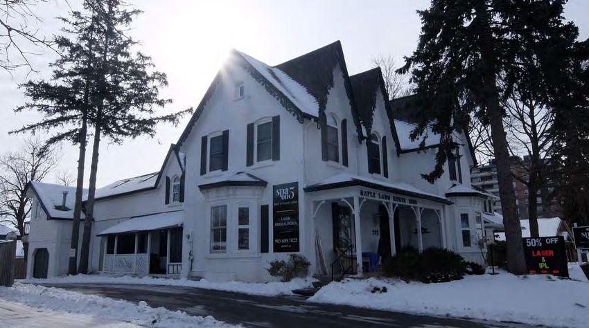
3.          Settlement Context
3.1         Indigenous Settlement
The area encompassing the former Township of East Flamborough and the Village of
Waterdown has attracted human settlement since long before their formal
establishment. The Grindstone Creek runs south through Waterdown towards Hamilton
Harbour and was central to an extensive trail network traveled by the Indigenous
Chonnonton People, commonly known as the Neutrals, which abounded with food and
resources such as sugar maple and salmon.5 These trails, the origins of contemporary
roads such as Snake Road and Old Waterdown Road, led the Neutrals from the base of
the escarpment to their settlements north and west of present day Waterdown.6
The Neutrals, dubbed as such by explorer Samuel Champlain in 1615 for their lack of
participation in wars between the neighbouring Huron and Iroquois people, were a
powerful chiefdom which traded extensively throughout present day Ontario and New
York.7 The Neutral’s population was decimated by a 1638 smallpox outbreak and
subsequent conflict and defeat by the Seneca and Mohawk during the Beaver Wars of
the mid-17th century.8 The Mississaugas, an Anishinaabe nation who inhabited the
lands east of the Neutrals, established settlement in the area following the Beaver Wars
and were the predominant Indigenous group at the time of arrival by European settlers.9
In the late 17th century, the Anishinaabe and Haudenosaunee nations established
peace with the “Dish with One Spoon” Wampum promising that the two nations would
share the bounty of the land (the dish) together (using one spoon).10

        Figure 2: Dish With One Spoon Wampum Belt Reproduction (utoronto.ca)

5 Donald R. Woods and Diane E. Woods, The Mills of Waterdown: The Growth of an Ontario Village –
1790 to 1915 (Waterdown, ON: The Waterdown – East Flamborough Heritage Society, 2010), 2-3; Sylvia
Wray, Robert Wray, Patricia Green and Maurice Green, …and they came to East Flamborough: A
Celebration of East Flamborough Township’s pre-Confederation Heritage (Waterdown, ON: The
Waterdown-East Flamborough Heritage Society, 2015), 18-19.
6 Waterdown-East Flamborough Centennial Committee, 1867-1967: Waterdown and East Flamborough

(Waterdown, ON: Waterdown-East Flamborough Centennial Committee, 1967), 41.
7 Woods and Woods, The Mills of Waterdown, 2-5.
8 Woods and Woods, The Mills of Waterdown, 2-5.; Patricia Green, Maurice Green, Sylvia Wray and

Robert Wray, from West Flamborough’s storied past (Waterdown, ON: The Waterdown – East
Flamborough Heritage Society, 2003), 2.
9 William C. Noble, "The Neutral Confederacy,” Canadian Encyclopedia, last modified October 16, 2018.

https://www.thecanadianencyclopedia.ca/en/article/neutral.; Green, Green, Wray and Wray, from West
Flamborough’s Storied Past, 2.
10 Nathan Tidridge, The Extraordinary History of Flamborough: East Flamborough, West Flamborough &

Waterdown (Waterdown, ON: The Waterdown-East Flamborough Heritage Society, 2016), 11.

CHAR (Draft): Maple Lawn, 292 Dundas Street East, Waterdown                            Page 9 of 61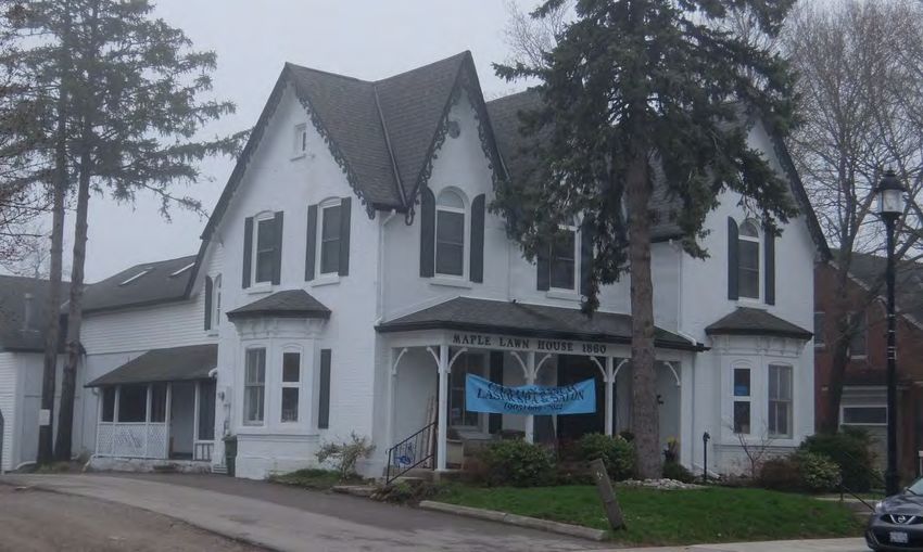
3.2        Euro Canadian Settlement
Beginning in the 1780s, Euro-Canadian settlement in the area superseded that of
Indigenous populations.11 The American War for Independence greatly influenced
settlement in the Flamborough and Waterdown area. Following the establishment of the
United States of America in 1783, approximately 30,000 British Loyalists were displaced
and sought refuge in Britain’s remaining North American colonies.12 In response to this
demand for settlement lands, fifteen land surrender treaties were negotiated between
the Crown and the Anishinaabe peoples living in present day Southern Ontario between
1783 and 1812.13 These treaties gave the colonial government authority to survey and
eventually distribute lands to Loyalists and other European settlers.14 In 1788, to further
facilitate the surveying of new settlement lands, the western extent of Quebec’s District
of Montreal was subdivided into four districts: Lunenburg, Mecklenburg, Nassau and
Hesse. The area which would become East Flamborough, and subsequently the Village
of Waterdown, was situated within the District of Nassau.15
In 1791, a portion of Quebec, including the new districts, was separated to establish the
Province of Upper Canada. Newly appointed Lieutenant Governor John Graves Simcoe
named Augustus Jones Provincial Land Surveyor and directed him to travel west from
the Niagara River to survey and lay out Townships.16 In 1792 Treaty No. 3, the Between
the Lakes Purchase, was negotiated between the Crown and the Mississaugas, giving
Upper Canada ownership and access to a vast swath of land between Lake Erie and
Lake Ontario.17 The final component of Jones’ initial survey was the Township of
Geneva, four concessions along the broken front of Lake Geneva, now known as
Burlington Bay. Geneva’s concessions were surveyed from the “Indian Point”, a line
which divided the lands to the west purchased by the crown, and the lands to the east
still claimed by the Mississaugas. Initially set out for refugees of the French Revolution,
an additional 10 concessions were surveyed to the north of Geneva and amalgamated
with the Township and the lands surrounding the town of Dundas to form the Township
of Flamborough in 1793.18

11 Noble, “The Neutral Confederacy.”
12 “Upper Canada Land Surrenders and the Williams Treaties (1764-1862/1923),” Government of
Canada, last modified February 15, 2013, https://www.rcaanc-
cirnac.gc.ca/eng/1360941656761/1544619778887#uc.
13 “Upper Canada Land Surrenders,” Government of Canada.
14 “Upper Canada Land Surrenders,” Government of Canada.
15 Wray, Wray, Green and Green, …and they came to East Flamborough, 1-3.
16 Wray, Wray, Green and Green, …and they came to East Flamborough, 1-3.
17 “Upper Canada Land Surrenders,” Government of Canada.; Donna Duric, “Between the Lakes Treaty

No. 3 (1792),” Mississaugas of the Credit First Nation, last modified May 18, 2017,
http://mncfn.ca/treaty3/.
18 Wray, Wray, Green and Green, …and they came to East Flamborough, 1-2.

CHAR (Draft): Maple Lawn, 292 Dundas Street East, Waterdown                       Page 10 of 61
Figure 3: Geneva concessions as illustrated on a map of the treaties with the
          Indigenous from the Mississaugas of the Credit First Nation webpage

Construction began in 1793 on a highway commissioned by Lt. Governor John Simcoe,
which initially ran westward from Burlington Bay to Joseph Brant’s village on the Grand
River.19 Subsequently, the previously established Land Board began accepting
applications for property grants in Flamborough, awarding land mostly to members of
the military and government officials who typically remained absentee landlords.20 In
1796, Lieutenant Alexander McDonnell was awarded approximately 3000 acres
including Lots 6 and 7 of Concession 3, the location of the original village core of
Waterdown.21 Following boundary realignments and territorial renaming within Upper
Canada between 1793 and 1798, the Township of Flamborough was split into the
Townships of East and West Flamborough in 1798. 22
McDonnell’s land went undeveloped and 800 acres were acquired by Alexander Brown
in 1805, who then established the area’s first sawmill above the Great Falls at Smokey
Hollow and the Grindstone Creek.23 That same year, Treaty No. 14, the Head of the
Lake Treaty, was negotiated and the Crown acquired Mississauga lands east of East
Flamborough, allowing for the easterly expansion of Lt. Governor Simcoe’s highway,

19 Sylvia Wray, Dundas Street, Waterdown, 1793-1993 (Waterdown, ON: The Waterdown-East
Flamborough Heritage Society, 1994), 3.
20 Wray, Wray, Green and Green, …and they came to East Flamborough, 2-3.
21 Wray, Wray, Green and Green, …and they came to East Flamborough, 2-3.; Unterman McPhail

Cuming Associates and Wendy Shearer Landscape Architect Limited, Waterdown Heritage Conservation
District Study: Heritage Assessment Report (1996), 2-1.; Woods and Woods, The Mills of Waterdown, 20.
22 Wray, From West Flamborough’s Storied Past, 4.
23 Wray, Wray, Green and Green, …and they came to East Flamborough, 18.; Woods and Woods, The

Mills of Waterdown, 21.

CHAR (Draft): Maple Lawn, 292 Dundas Street East, Waterdown                          Page 11 of 61
which would become Provincial Highway 5 and Dundas Street in Waterdown.24 While previously difficult to access and largely untouched, the road and potential for water power made settlement in East Flamborough appealing to many, and slowly settlement and associated industry increased throughout the early 19th century.25 Lieutenant Governor Simcoe’s highway was a response to concerns about surprise attacks from the newly liberated American colonies and was intended to serve as a military passage for the movement of troops and supplies. Its secondary purpose was a means of encouraging settlement; however, construction did not begin until Simcoe’s decision to move the capital to present day London. The first section of it, which became known as The Governor’s Road, stretched from Burlington Bay to the Grand River. The second section was intended to extend the road to London, but Simcoe changed the location of the capital to York (modern day Toronto) causing construction to cease and nature to retake their hard work. Land grants were offered along this strip of highway with the stipulation that owners were required to keep the roadway clear. Work on the trail from Dundas began immediately following the movement of the capital but the second section of it, which stretched from Burlington Bay to York, was not started until a decade later due to the success of water transportation along Lake Ontario. This road from Dundas to York was named the Dundas Highway in honour of Henry Dundas, the Home Secretary responsible for Colonial Affairs. This roadway began as an Indigenous trail before being turned into a highway serving an important role in the history of both Waterdown and Ontario.26 In 1823, Ebenezer C. Griffin arrived in the area, having previously purchased the majority of Concession 3, Lot 7 from Alexander Brown.27 He established a number of businesses, including a store at the corner of Mill and Dundas Street, a flour mill above the Great Falls, and a carding mill on Mill Street South.28 The area came to be known as Waterdown, and in 1831 Griffin prepared a village plan which became known as the Griffin Survey and began to sell off lots.29 In 1836, E.C Griffin sold his mill operations at what would become known as Smokey Hollow to George Abrey and John Heywood and in 1837 received a grant to Concession 3, Lot 6.30 George Allison George Allison was a farmer from Carlisle that moved to Waterdown for his retirement and became a local magistrate. He married Elizabeth Revell (1845-1871), who died of consumption at an early age, then on September 4, 1872 remarried Mary Ann Hardbottle (1837-1885), who also died young. He then married Annette Eliza Gildart 24 Wray, Dundas Street, 4; Wray, Wray, Green and Green, …and they came to East Flamborough, 3.; Donna Duric, “Head of the Lake, Treaty No. 14 (1806),” Mississaugas of the Credit First Nation, last modified May 28, 2017, http://mncfn.ca/head-of-the-lake-purchase-treaty-14/. 25 Wray, Wray, Green and Green, …and they came to East Flamborough, 18. 26 Wray, Dundas Street, 3-5. 27 Woods and Woods, The Mills of Waterdown, 44. 28 Woods and Woods, The Mills of Waterdown, 44-46. 29 Woods and Woods, The Mills of Waterdown, 50-54.; Wray, Wray, Green and Green, …and they came to East Flamborough, 18. 30 Woods and Woods, The Mills of Waterdown, 52. CHAR (Draft): Maple Lawn, 292 Dundas Street East, Waterdown Page 12 of 61
Feilde (1860-1912) on November 10, 1886. They had seven children: Jane (1887-
1954), George Feilde (1889-1981), Harriett (1894-1974), Rosalind (born 1894),
Alexander (1896-1989), and Adela (1898-1901).31 George Allison was a member of the
Ontario Historical Society and was well known for his collection of First Nations artifacts,
many of which were donated to the Royal Ontario Museum in Toronto; however, his
treatment of these artifacts has been scrutinized for leaving some of them open to the
elements and melting some of the metal objects into a small cannon.32

The Flamborough Review and Harold Greene
The Flamborough Review was first published on May 16, 1918 under the name of the
Waterdown Review. It was founded and published by George Harold Greene with the
first issue being assembled in a small office in the former Bell House (where Memorial
Hall is now). The first issue of the Waterdown Review only had twelve subscribers;
however, this first issue was sent internationally when a local doctor, Dr. McGregor,
bought fifty copies and sent them to the local soldiers fighting in the First World War.33
Before the Great Fire of 1922, the newspaper office moved from the Bell House to a
building on Flamboro Street, which is believed to have the carriage house of Green’s
home at 292 Dundas Street East (now a private residence at 10 Flamboro Street).
Greene retired in January of 1940, leaving the newspaper to Gillivray S. McRae who
moved the Review to Main Street North in 1948 (Figures 5). In 1952, McRae died and
his wife, Frances, took over the operation of the newspaper until 1960 when she
stepped back to a reporter position (until 1972) covering the Waterdown Village Council
and a weekly column.34

 Figure 4: Excerpt from the Waterdown 1937 Fire Insurance Plan depicting the location
 of the Waterdown Review Printing building on Flamboro Street (highlighted in red), to
        the southeast of 292 Dundas Street East (shown as #25 Dundas Street)

31 Robert A. Lalonde, Feilde Family of Flamborough: Frederick Cazalet Feilde 1797-1883 Ancestors and
Descendants (Waterdown, ON: Robert A. Lalonde, 2012).
32 Michelle Hamilton, Collections and Objections: Aboriginal Material Culture in Southern Ontario (Montreal,

QC: McGill-Queen’s University Press, 2010).
33 Mac Christie, “100 Years: Reviewing the Flamborough Review,” Flamborough Review, February 1, 2018,

https://www.flamboroughreview.com/community-story/8105066-100-years-reviewing-the-flamborough-review/.
34 Christie, “100 Years: Reviewing the Flamborough Review,” Flamborough Review.

CHAR (Draft): Maple Lawn, 292 Dundas Street East, Waterdown                                 Page 13 of 61
Figures 5 and 6 (l to r): Waterdown Review, 30 Main Street North, 1976; An artist's
rendering of the Flamborough Review located at 30 Main Street North; Source:
Hamilton Public Library, photograph by JBH; Flamborough Review article "Flamborough
Review Relocating Office,” January 16, 2018
John Vellinga and Sons of Chatham bought the Waterdown Review in 1960 and, in
1976, renamed the newspaper the Flamborough Review to align with the formation of
the Regional Government in 1974.The first Flamborough Review issue was published
on January 5, 1977. In January of 1988, John Bosveld the son-in-law of John Vellinga,
who had been the sole proprietor since 1965, died leaving the newspaper to his wife
and sons. In 1996, Southam purchased the newspaper then Hollinger and CanWest. In
2003, Metroland Media purchased the Flamborough Review making it a division of the
Torstar Corporation.35
Subject Property – Block C Village Lot 4, Plan M12 Lot 85 (See Appendix E:
Ownership History)
The subject property is part of Lot 7 Concession 3, which was granted by the Crown to
Alexander MacDonnell in 1796. In 1805, Alexander Brown purchased MacDonnell’s two
hundred acres then subsequently sold one hundred and fifty-five of those acres to E.C.
Griffin in 1821.36 Absolom Griffin purchased sixty-one of these acres in 183037 selling
three acres to Job Barton in 1855.38 Job Barton sold village lot 4 on the south side of
Dundas Street totaling one-third of an acre to Soloman Griffin in 1868.39 The 1875 map
of Waterdown indicates that Charles Sealey owned this property as part of a larger
parcel; however, there is no other documentary evidence to confirm this indication.
35
Christie, “100 Years: Reviewing the Flamborough Review,” Flamborough Review.
36
“Hamilton Wentworth (62), Waterdown, Book 1 Waterdown; Parts of Lot 6 and 7; Concession 3 East
Flamborough; Prior Title to E.C. Griffins Survey; Village Lot in Waterdown,” Ontario Land Registry
Access, 4-5, https://www.onland.ca/ui/62/books/21129/viewer/279447577?page=4.
37
“Hamilton Wentworth (62), Waterdown, Book 1,” Ontario Land Registry Access, 4-5.
38
“Hamilton Wentworth (62), Waterdown, Book 1,” Ontario Land Registry Access, 34-35.
39
“Hamilton Wentworth (62), Waterdown, Book 1,” Ontario Land Registry Access, 76-77.
CHAR (Draft): Maple Lawn, 292 Dundas Street East, Waterdown Page 14 of 61More information and research are necessary to fully explore this possibility. In 1887, Soloman Griffin sold this property to George Allison.40 George Allison maintained ownership of this property until 1915 when he sold it to Dora Watson. By the end of the same year, Dora Watson had granted the property back to George Allison who then sold it to Mary Feilde in 1918. Three years later, Mary Feilde granted the property to George Greene and his wife Agnes. George and Agnes Greene sold the property in 1928 to David Craft and his wife Martha. David Craft, now a widower, granted the property to Rudolph Lilja and his wife Myrtle in 1941.41 Rudolph and Myrtle Lilja owned the property for twenty-three years before selling to Ivor and Myrtle Witheridge in 1964.42 According to a recent title search, Ivor and Myrtle Witheridge sold the property to William and Ruth Morey in 1989. In 2006, the Moreys sold the property to Tara Arnold, who owned the property until 2018 when Floyd Holdings Inc. purchased the property. The sign located on the fascia of the verandah roof indicates a construction date of 1860. It is difficult to confirm this suggestion since the available tax assessment records for Waterdown start in 1880; however, the evaluations available do not support this early of a construction date. According to the available tax assessment records, the property was valued at $150 in 1882 with a significant increase in value in 1887 to $3000. Research suggests that the building located on the property was constructed for George Allison, who purchased the property in the same year as the significant increase in value (1887). This is not to say that a structure did not exist on the property prior to 1887; however, considering the low evaluation of the property in 1882 and the indication that the structure was built for George Allison, it is believed that the current building was not constructed until 1887. 3.3 Contemporary Context The subject property is located near the southeast corner of Dundas Street East and Hamilton Street North. The immediate area on the north and south sides of Dundas Street East feature variably-sized commercial buildings, many of which are converted from former dwellings, that possess various setbacks, heights and styles. The east and west sides of Hamilton Street North are comprised of contemporary commercial structures of varying setbacks, heights and styles whereas the east and west sides of Hamilton Street South contain residential structures of the same varying details. The streetscape is characterized mostly by commercial driveways and businesses set close to the road with some tree cover and front-facing landscaping. 40 “Hamilton Wentworth (62), Waterdown, Book 1,” Ontario Land Registry Access, 144-145. 41 “Hamilton Wentworth (62), Waterdown, Book 4: Part 2; Plan 355 and 741,” Ontario Land Registry Access, 90-91, https://www.onland.ca/ui/62/books/21120/viewer/1000477226?page=90. 42 “Hamilton Wentworth (62), Waterdown, Book 8: Survey Plan 355, 741, 198,” Ontario Land Registry Access, 143, https://www.onland.ca/ui/62/books/21126/viewer/964833290?page=143. CHAR (Draft): Maple Lawn, 292 Dundas Street East, Waterdown Page 15 of 61
Figure 7: South side of Dundas Street looking west from 290 Dundas Street (June
                                       2018)

Figure 8: Twentieth-century commercial buildings west and north of 292 Dundas Street
            East, looking northwest towards Hamilton Street (June 2018)

CHAR (Draft): Maple Lawn, 292 Dundas Street East, Waterdown            Page 16 of 61
Figure 9: South side of Dundas Street looking east from 290 Dundas Street (June 2018)
Figure 10: South side of Dundas Street looking East from Hamilton Street showing the
tree canopy, 292 Dundas Street East at the middle right (June 2018)
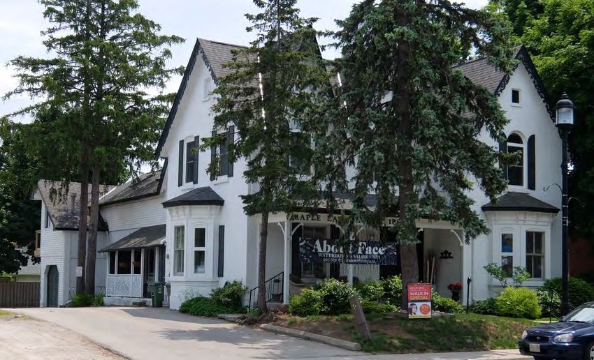
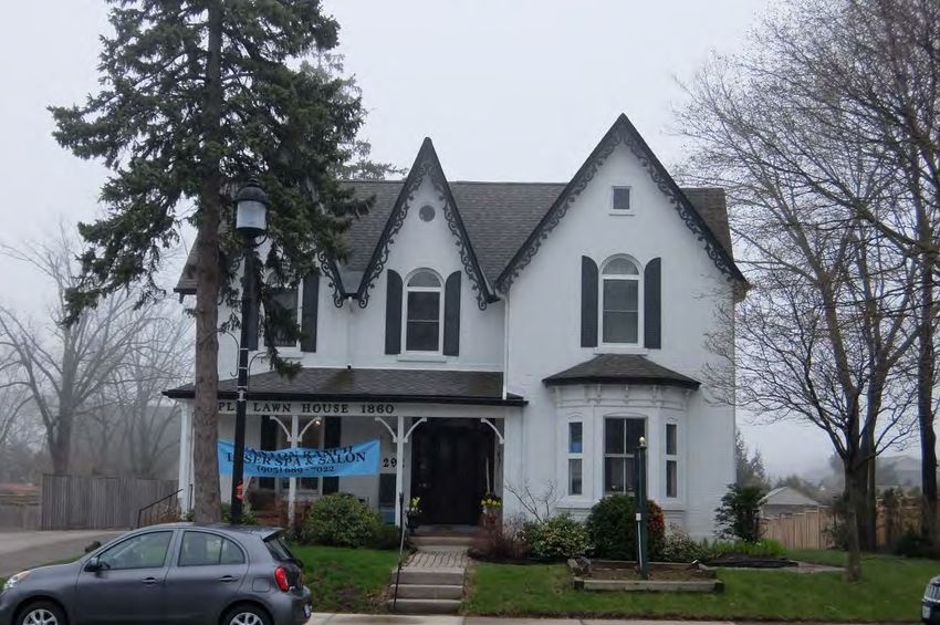
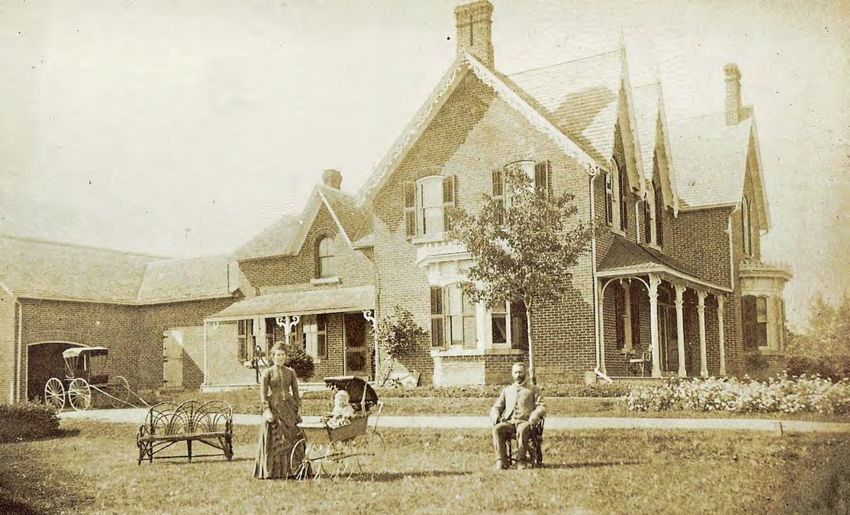
CHAR (Draft): Maple Lawn, 292 Dundas Street East, Waterdown Page 17 of 614. Property Description The 0.29-acre property at 292 Dundas Street East is comprised of a two-storey single- detached brick building, situated on the south side of Dundas Street East, east of the corner of Dundas Street and Hamilton Street in the former Village of Waterdown and the former Township of East Flamborough, within the City of Hamilton. Figure 11: 292 Dundas Street East, highlighted in grey, City of Hamilton GISnet, 2019 4.1 Evolution of the Buildings and Landscape The two-storey brick building was constructed as a dwelling circa 1887 (Figure 12) and has been sympathetically adaptively reused for commercial use, with many of its original heritage features conserved (Figure 13). The 1939 Fire Insurance Plan of the Village (Figure 14) indicates that the property consisted of a principal two-storey dwelling fronting onto Dundas Street and was used as a “tourist home” in the early- twentieth century. CHAR (Draft): Maple Lawn, 292 Dundas Street East, Waterdown Page 18 of 61
Figure 12: 292 Dundas Street East, Waterdown, circa 1888; Source: Flamborough
                                Archives, BW 2836

           Figure 13: 292 Dundas Street East, Waterdown, January 2020

CHAR (Draft): Maple Lawn, 292 Dundas Street East, Waterdown         Page 19 of 61
Figure 14: Insurance Plan of the Village of Waterdown, ON, May 1939, Excerpt of Sheet
1 (Existing property boundary of 292 Dundas Street East highlighted in red)
An early heritage assessment of the property prepared circa 1982 described it as "a
Victorian Ontario country estate in an urban setting, with "a small, treed lot with a spring
well on the east side".43 Previous research indicates that Allison was a local juror and
magistrate and that many people who visit the house to obtain marriage licenses, as
well as to draw water from the spring well beside the house. The residence is believed
to have been converted for commercial use in the early 1990s, circa 1993.
The most notable alterations that have taken place to the building, and its surroundings,
include:
• Removal of the former spring well;
• Removal of the brick chimneys on the north, east and south elevations (before
1977);
• Removal of the iron cresting along the roof edge of the ground-floor bay windows
on the north and east facades (before 1977);
• Removal of the functional wood shutters (before 1977), and introduction of
ornamental shutters on some windows (circa 1980);
• Removal of the eastern section of the attached coach house (circa 1980s);
43 WAT 0.21, “LACAC Evaluation Report,” City of Hamilton Planning Department Archives.
CHAR (Draft): Maple Lawn, 292 Dundas Street East, Waterdown Page 20 of 61• Painting of the red brick exterior (before 1977);
• Removal of the finials on the twin gables on the north facade (before 1977);
• Replacement of the tin roof on the north and east facade verandahs with asphalt
shingles (before 1977);
• Replacement of the north facade verandah posts and decorative trim features
(before 1977);
• Reduction of the front yard and gardens and removal of some mature trees
allowing for the introduction of parking in the rear (circa 1993);
• Introduction (between 1993 and 2011) and subsequent removal (between 2012
and 2018) of fabric awnings on the north bay window and the roof of the north
facade verandah directly in front of the entrance;
• Partial enclosure of the side (east) verandah (between 1993 and 2011);
• Addition of a second storey over the remaining rear coach house (between 1993
and 2018);
• Cladding of the second-storey of the rear wing with siding (between 1993 and
2018);
• Introduction of a side walkway to the side (north) verandah (between 1993 and
2011); and,
• Replacement of the wooden sash windows with contemporary windows,
including the trefoil semi-circular transoms in the second-storey windows
(between 2012 and 2018).
4.2 Building Description
The property is comprised of a two-storey, single-detached brick building believed to
have been constructed in 1887. The subject property is a representative example of a
vernacular farmhouse dwelling influenced by the Gothic Revival and Italianate
architectural styles, including the:
• T-shaped footprint;
• Brick facades laid in Stretcher bond;
• Stone foundation;
• T-shaped gable roof with:
o Paired high-pitched projecting gables to the front (north) and side(west);
o Projecting eaves and verges;
o Decorative bargeboard under the front gables;
CHAR (Draft): Maple Lawn, 292 Dundas Street East, Waterdown Page 21 of 61• One-storey projecting bay windows on the front (north) and side (east) facades
including:
o Hipped roof with plain boxed cornice and decorative brackets; and,
o Segmental window openings.
• Semi-elliptical window openings on the second floor of the front facade with brick
voussoirs and stone lug sills;
• Segmental window openings in the first and second storeys with brick voussoirs
and stone lug sills;
• Covered front porch with a hip roof and projecting eaves;
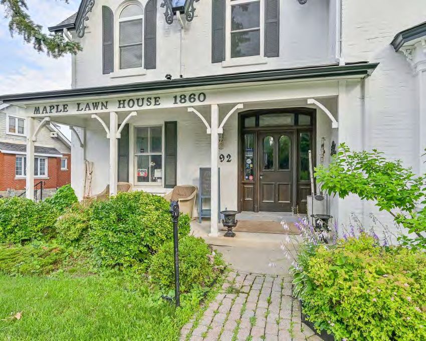
• “MAPLE LAWN HOUSE 1860” lettering;
• Central front entrance with a single, four-panel wooden door including semi-
circular upper panels of plain glass and moulded, wooden bottom panels, with
segmentally-shaped three-pane transom, flanking sidelights and paneled door
surround;
• One-and-a-half storey rear wing, including the:
o Gable roof with projecting eaves;
o Projecting gables to the east and west with semi-circular windows below
the gables;
o Segmentally-shaped window openings in the first storey with brick
voussoirs and stone lug sills; and,
o Covered side (east) porch with a hip roof.
• Remaining first-storey portion of the former coach house attached to the rear
wing.
The historic interior features include the:
• Seventeen-tread staircase leading to the second storey from the front hallway
with wooden balusters on each tread, a decorated string and wooden detailing on
the side of each tread;
• Wooden baseboards and door mouldings;
• Wainscoting in the area past the front hallway staircase; and,
• Ceiling mouldings on the first storey.
CHAR (Draft): Maple Lawn, 292 Dundas Street East, Waterdown Page 22 of 61Figure 15: Aerial view of 292 Dundas Street East, City of Hamilton GISnet, 2019
(Excerpt showing the T-shaped front portion in red, the one-and-a-half storey rear wing
in yellow and the former carriage house in light blue)
CHAR (Draft): Maple Lawn, 292 Dundas Street East, Waterdown Page 23 of 615. Cultural Heritage Evaluation The following is an evaluation of the cultural heritage value or interest of the subject property, in accordance with Ontario Regulation 9/06 and the City of Hamilton’s Framework for Cultural Heritage Evaluation. The subject property has been evaluated against three sets of criteria – Archaeology, Built Heritage, and Cultural Heritage Landscapes – as follows: 5.1 Archaeology Identified or potential archaeological resources can be considered as values meriting inclusion into the identified cultural heritage value for the designation of a property. A set of twelve criteria is used to evaluate an archaeological site or measure archaeological potential to determine what attributes, if any, warrant designation under Part IV of the Ontario Heritage Act. The first eleven criteria for designation of an archaeological site are predicated on the presence of an archaeological site. In the case of 292 Dundas Street East, there are no registered or reported archaeological sites located on the subject property. As a result, only the Archaeological Potential criterion applies in this assessment. Archaeological Criteria Cultural Definition: N/A Site Setting: N/A Temporal Integrity: N/A Site Socio-political Value: N/A Site Size: N/A Site Uniqueness: N/A Site Type: N/A Site Rarity: N/A Site Integrity: N/A Site Human Remains: N/A Historical Association: N/A Archaeological Site Potential: Applicable 5.1.1 Archaeological Potential The subject property comprises a two-storey building, situated in an urban context first developed in the late-nineteenth century. To be considered an area of archeological potential, the site must meet one of the primary criteria or two of the secondary criteria. The subject property meets one primary criterion because it is within two hundred and fifty metres of a known archaeological site (AiGx-373). It is also within an area of sandy soil, within one hundred metres of a historic transportation corridor (Dundas Street) and within a historic urban boundary (Waterdown Village) meaning it meets three secondary criteria. Since this property meets one primary criterion and three secondary criteria, it retains archeological potential and, therefore, this criterion is considered satisfied. CHAR (Draft): Maple Lawn, 292 Dundas Street East, Waterdown Page 24 of 61
5.2        Built Heritage
A set of twelve criteria is used to identify and assess the built heritage value of a
property. Of the twelve criteria, nine were applicable and satisfied for 292 Dundas Street
East.
 Historical Associations                      Architecture and Design
 Thematic: Applicable                         Architectural Merit: Applicable
 Event: N/A                                   Functional Merit: N/A
 Person and/or Group: Applicable              Designer: Unknown
 Integrity                                    Environmental Context
 Location Integrity: Applicable               Landmark: Applicable
                                              Character: Applicable
 Built Integrity: Applicable
                                              Setting: Applicable
 Social Value
 Public Perception: Applicable

5.2.1      Historical Associations

Thematic
The property has direct associations with the themes of village development,
commercial growth and adaptive reuse as indicated in the history of the property in
relation to the history of the village.
As depicted in the 1854 Griffin survey, this property was located close to the southwest
edge of the village. In 1887, George Allison purchased the yet to be developed property
and constructed a house in the same year. As the village developed, the southwest
limits of the village moved farther from this property changing its context from a purely
residential area to a mixed commercial and residential area and, finally, to a solely
commercial area. This change encouraged the later conversion of the property to
commercial use. This conversion was not conducted as a demolition of the original
structure and rebuild of a new one, but as an adaptive reuse of the existing building
consistent with a number of other examples along Dundas Street. This indicates a focus
on heritage preservation that is still quite prevalent within the Village today. However, a
significant change in the landscape of the property was necessary to make room for
required parking and foot traffic resulting in the loss of its mature trees. These changes
are consistent with characteristics of commercial areas, which often consist of more
built features than natural ones and is a visual representation of the expansion of the
commercial core of Waterdown. Therefore, this criterion is considered satisfied.

Event
A specific event that has made a significant contribution to Waterdown, Ontario or
Canada is not known to have occurred here.

CHAR (Draft): Maple Lawn, 292 Dundas Street East, Waterdown                 Page 25 of 61
Person/Group The property has direct association with George Allison (1841-1926) and George Greene (1874-1960). George Allison was a farmer, local magistrate and a member of the Ontario Historical Society. He was well known for his collection of First Nations artifacts, many of which were donated to the Royal Ontario Museum in Toronto; however, his treatment of these artifacts has been scrutinized for leaving artifacts open to the elements and the melting down of some metal artifacts to make a small cannon. George Harold Greene was the first publisher of the Waterdown Review. It is believed that a few of the early newspapers were produced in the carriage house of this property; however, research has not confirmed this belief. This is an avenue of research worth pursuing, if given the opportunity. Therefore, this criterion is considered satisfied. 5.2.2 Architecture and Design Architectural Merit The property is comprised of a two-storey brick farmhouse-style building influenced by the Gothic Revival and Italianate architecture. It was constructed circa 1887 as a residence and was later converted for commercial use. The architectural merit of the building lies in its features typical of a late-nineteenth century farm house, including the: T-shaped footprint; cross-gable roof; brick construction; covered front porch; and, combination of semi-elliptical and segmentally-shaped window openings with brick voussoirs and stone lug sills. The architectural merit of the building also lies in its features influenced by the Gothic Revival architectural style, including the three high pitched gables with decorative bargeboard, features influenced by the Italianate style, including the hipped-roof bay windows with decorative brackets. The property also exhibits a high degree of craftsmanship and artistic merit, including the: decorative bargeboard; bay windows with Italianate detailing; and, front entrance with wooden paneled surround, multi-pane transom and flanking sidelights. Therefore, this criterion is considered satisfied. Functional Merit The subject property was constructed as a residence circa 1887. It is a typical example of a brick structure using typical construction methods and does not possess any utilitarian features. Therefore, this criterion is not considered satisfied. Designer A previous report identified Soutar as the architect; however, this has not been confirmed by documentary sources. The designer of the building is unknown based on the research conducted. This is subject to further research and information. Therefore, this criterion is not considered satisfied. CHAR (Draft): Maple Lawn, 292 Dundas Street East, Waterdown Page 26 of 61
5.2.3       Integrity

Location Integrity
The building located at 292 Dundas Street East remains in its original location This fact
is important since a historic building in its original location has greater cultural heritage
value than one that has been moved from its original site. Therefore, this criterion is
considered satisfied.

Built Integrity
Despite some alterations, many of the original features of the building remain. Notable
building features that appear to be original to the building include the: brick facades laid
in Stretcher bond; wooden decorative bargeboard in the gables; projecting bay windows
with decorative brackets; segmentally and semi-elliptically-shaped window openings
with brick voussoirs and stone lug sills; central entrance with transom and sidelights;
and, covered front (north) and side (east) porches.
In addition, some of the original interior elements remain intact including the: wooden
baseboards and door mouldings; ceiling mouldings in the northern rooms of the first
storey; wainscoting; and, seventeen-tread staircase leading from the front hallway to the
second storey with balusters on each tread, a decorated string, and wooden detailing on
the side of each tread. Therefore, this criterion is considered satisfied.

5.2.4       Environmental Context

Landmark
The property is considered a local landmark. It is an important feature on Dundas Street
marking the transition between the commercial area to the west and the historic
downtown core. This property is also the beginning of a series of residences converted
into commercial use that line the north and south sides of Dundas Street East between
Hamilton Street and Main Street. The “MAPLE LAWN HOUSE 1860” sign, located on
the fascia of the front-facing verandah, makes this property recognizable at a glance
and indicates its defining role in the community. Therefore, this criterion is considered
satisfied.

Character
The north and south sides of Dundas Street East, west of Main Street North, have
evolved from mostly farm land with some residential and commercial properties in the
mid-nineteenth century, to a mixed streetscape consisting of residential and commercial
buildings in the late-nineteenth century with later additions of some institutional
buildings in the twentieth century, to the current commercial streetscape.
The property is important in defining the historic character of the area. The late-
nineteenth century single-detached building defines the early residential character on

CHAR (Draft): Maple Lawn, 292 Dundas Street East, Waterdown                    Page 27 of 61
the west end of Dundas Street and is physically, visually and historically linked to its
surroundings. The streetscape is characterized by buildings of generally traditional
building materials (brick, stone, wood, stucco), heights ranging from one-and-a-half to
two-and-a-half storeys, and eclectic architectural styles that demonstrate the
development of the Village of Waterdown throughout its history, particularly within the
downtown core. Therefore, this criterion is considered satisfied.

Setting
The property contributes to the character of Dundas Street East, which features
buildings of various ages and architectural influences. This section of Dundas Street
East includes one-and-a-half to three storey buildings dating between the mid-
nineteenth century to modern day. This property helps mark the transition from the
modern shopping complexes and structures further west to the historic downtown core
of Waterdown further east. Therefore, this criterion is considered satisfied.

5.2.5      Social Value

Public Perception
Through its inclusion in various Waterdown specific histories and studies, the subject
property has continued to demonstrate its value to the village.
Maple Lawn (292 Dundas Street East) was included in Sylvia Wray and Maurice
Green’s Dundas Street Waterdown 1793-1993, which documents the history of the main
thoroughfare in the village. The history of the building and its occupants is outlined, and
historic photographs included to showcase it as one of few significant residences that
existed on Dundas Street during the indicated period.
The subject property was included in a historic walking tour hosted by the Flamborough
Archives, has been previously evaluated by the former Local Architectural Conservation
Advisory Committee of Waterdown, as part of the Canadian Inventory of Historic
Building (CIHB), and was evaluated by the Canadian Ministry of Transportation and
Communications in 1983 as part of a report to determine the impact of the widening of
Dundas Street between Evans and Syndenham Roads.
The property has also been given various names over time including: Maple Lawn,
believed to refer to the maple trees located within its yard; The Gables, after the design
of the house with its multiple gabled rooflines; and, Witheridge, named after one of the
owners of the property Ivor Witheridge. Therefore, this criterion is considered satisfied.

5.3        Cultural Heritage Landscapes
A set of nine criteria is used to identify and assess the potential for a cultural heritage
landscape. In the case of 292 Dundas Street East, the subject property does contain
mature trees and is a part of two identified landscapes, Dundas Street and the Village of

CHAR (Draft): Maple Lawn, 292 Dundas Street East, Waterdown                 Page 28 of 61
Waterdown, but on its own is not considered to be a cultural heritage landscape. As a
result, none of the Cultural Heritage Landscape criteria apply.
 Historical Associations                     Scenic Amenity
 Thematic: N/A                               Sense of Place: N/A
 Event: N/A                                  Serial Vision: N/A
 Person and/or Group: N/A                    Material Content: N/A
 Integrity                                   Design
 Integrity: N/A                              Design: N/A
 Social Value
 Public Perception: N/A

CHAR (Draft): Maple Lawn, 292 Dundas Street East, Waterdown              Page 29 of 61
6.         Cultural Heritage Value: Conclusions
           and Recommendations
6.1        Conclusions
The subject property possesses high archeological potential but does not satisfy any of
the other eleven criteria indicated under the City’s guidelines for archeology. In addition,
the property is not considered to be a cultural heritage landscape. Therefore, the
subject property is not considered to have heritage value worthy of designation
according to those two categories.
The subject property does satisfy nine of the twelve criteria pertaining to built heritage,
including:
   •   Historical Associations:
          o Thematic
          o Person and/or Group
   •   Architecture and Design:
          o Architectural Merit
   •   Integrity:
          o Location Integrity
          o Built Integrity
   •   Environmental Context:
          o Landmark
          o Character
          o Setting
   •   Social Value:
          o Public Perception

6.2        Compliance with Ontario Regulation 9/06: Criteria for
           Determining Cultural Heritage Value or Interest
According to Subsection 1 (2) of Ontario Regulation 9/06, Criteria for Determining
Cultural Heritage Value or Interest, a property may be designated under section 29 of
the Ontario Heritage Act if it meets one or more of the following criteria:

CHAR (Draft): Maple Lawn, 292 Dundas Street East, Waterdown                  Page 30 of 61
1) The property has design value or physical value because it,
i) is a rare, unique, representative or early example of a style, type, expression,
material or construction method,
ii) displays a high degree of craftsmanship or artistic merit, or
iii) demonstrates a high degree of technical or scientific achievement.
2) The property has historical value or associative value because it,
i) has direct associations with a theme, event, belief, person, activity,
organization or institution that is significant to a community,
ii) yields, or has the potential to yield, information that contributes to an
understanding of a community or culture, or
iii) demonstrates or reflects the work or ideas of an architect, artist, builder,
designer or theorist who is significant to a community.
3) The property has contextual value because it,
i) is important in defining, maintaining or supporting the character of an area,
ii) is physically, functionally, visually or historically linked to its surroundings, or
iii) is a landmark.
The subject property has design value because it is a representative example of an
architectural style and displays a high degree of craftsmanship; it has historical value
because it has direct associations with a person significant to the community; and, it has
contextual value because it is important in defining the character of the area, is
physically, visually and historically linked to its surroundings and is considered to be a
local landmark. The following is a summary of the cultural heritage value of the subject
property according to Ontario Regulation 9/06:
6.2.1 Design / Physical Value
The property is comprised of a two-storey brick farmhouse-style building influenced by
the Gothic Revival and Italianate architectural styles. It was constructed circa 1887 as a
residence and was later converted for commercial use. The design value of the building
lies in its architectural features typical of a late-nineteenth century farm house, including
the: T-shaped footprint; cross-gable roof; brick construction; covered front porch; and,
combination of semi-elliptical and segmentally-shaped window openings with brick
voussoirs and stone lug sills. The architectural merit of the building also lies in its
features influenced by the Gothic Revival architectural style, including the three high
pitched gables with decorative bargeboard, features influenced by the Italianate style,
including the hipped-roof bay windows with decorative brackets.
CHAR (Draft): Maple Lawn, 292 Dundas Street East, Waterdown Page 31 of 61You can also read