OFFICE FOR OUTER SPACE AFFAIRS - Current and Planned Global and Regional Navigation Satellite Systems and Satellite-based Augmentations Systems ...
←
→
Page content transcription
If your browser does not render page correctly, please read the page content below

UNITED NATIONS
               OFFICE FOR OUTER SPACE AFFAIRS

Current and Planned Global and Regional Navigation Satellite
    Systems and Satellite-based Augmentations Systems

    International Committee on Global Navigation Satellite Systems Provider’s Forum

                                 UNITED NATIONS

UNITED NATIONS
   OFFICE FOR OUTER SPACE AFFAIRS

Current and planned global and
 regional navigation satellite
  systems and satellite-based
    augmentation systems
                        of the
International Committee on Global Navigation Satellite
               Systems Providers’ Forum

                    UNITED NATIONS
                     New York, 2010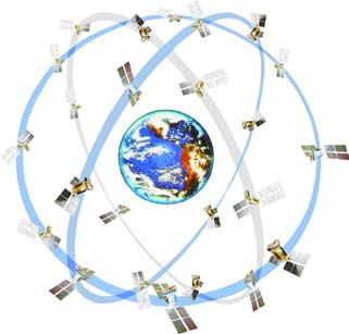
ST/SPACE/50
Preface
This report was produced by the Office for Outer Space Affairs of the United Nations,
in its capacity as executive secretariat of the International Committee on Global Navigation
Satellite Systems (ICG), on the basis of reports submitted by the members of the ICG
Providers’ Forum on their planned or existing systems and on the policies and procedures
that govern the service they provide.

The purpose of this publication is to provide the user community and receiver-producing
industry with a clear and consistent description of the global and regional systems that
are currently operating and that will operate in the future. In order to reflect changes
that will take place in the future, the publication will be updated as necessary. Readers
should go to the website of ICG (www.icgsecretariat.org) for further information. The
executive secretariat of ICG welcomes any suggestions on how to develop this document
for the benefit of the global navigation satellite systems community.

                                             iii
Contents
I. United States
The Global Positioning System and the Wide-Area Augmentation System 1
II. Russian Federation
The Global Navigation Satellite System 13
III. European Union
The European Satellite Navigation System and the European Geostationary
Navigation Overlay Service 19
IV. China
The Compass/BeiDou Navigation Satellite System 35
V. Japan
The Multi-functional Transport Satellite Satellite-based
Augmentation System and the Quasi-Zenith Satellite System 41
VI. India
The Indian Regional Navigation Satellite System and
the Global Positioning System-aided GEO-Augmented Navigation System 51
Annex
Technical parameters 57
vGPS/WAAS
I. United States
The Global Positioning System and the
Wide-Area Augmentation System
System description
Space segment
Global Positioning System constellation
The global positioning system (GPS) baseline constellation consists of 24 slots in six orbital
planes, with four slots per plane. Three of the slots are expandable and can hold no more
than two satellites. Satellites that are not occupying a defined slot in the GPS constellation
occupy other locations in the six orbital planes. Constellation reference orbit parameters
and slot assignments as of the defined epoch are described in the fourth edition of the
GPS Standard Positioning Service Performance Specification, dated September 2008. As
of that date, the GPS constellation had 30 operational satellites broadcasting healthy
navigation signals: 11 in Block IIA, 12 in Block IIR and 7 in Block IIR-M.
Wide-Area Augmentation System
The Wide-Area Augmentation System (WAAS) currently relies on the service of two
leased geostationary satellites positioned at 107° W latitude and 133° W longitude. On
3 April 2010, the telemetry tracking and control system on the Intelsat satellite (positioned
at 133° W longitude) failed. Mitigation efforts are under way to ensure that dual coverage
requirements are met over the long term. The objective of this System is to provide a
user receiver with at least two geostationary satellites in view during localizer performance
vertical operations.
1GPS/WAAS
Current and Planned Global and Regional Navigation Satellite Systems
Ground segment
Operational control segment of the Global Positioning System
The GPS operational control segment consists of four major subsystems: a master control
station, an alternate master control station, a network of four ground antennas and a
network of globally distributed monitor stations. The master control station is located
at Schriever Air Force Base, in Colorado, United States, and is the central control node
for the GPS constellation. Operations are maintained 24 hours a day, seven days a week.
The master control station is responsible for all aspects of constellation command and
control, including the following:
• Routine satellite bus and payload status monitoring
• Satellite maintenance and anomaly resolution
• Management of signal-in-space performance in support of the GPS standard
positioning service and precise positioning service performance standards
• Navigation message data upload operations as required to sustain performance in
accordance with accuracy and integrity performance standards
• Detecting and responding to GPS signal-in-space failures
In September 2007, the GPS operational control segment was modernized by transitioning
from a 1970s-era mainframe computer-based system at the master control station, to a
contemporary, distributed system known as the “architecture evolution plan”. In addition
to improving launch and early orbit, anomaly resolution and disposal operations, the
plan has resulted in:
• Increased capacity for monitoring GPS signals, from 96.4 to 100 per cent worldwide
coverage with double coverage over 99.8 per cent of the world
• Increased worldwide commanding capability, from 92.7 to 94.5 per cent while
providing nearly double the back-up capability
Ground segment of the Wide-Area Augmentation System
There are 38 wide-area reference stations throughout North America (in Canada, Mexico
and the United States, including Alaska and Hawaii) and Puerto Rico. The Federal
2GPS/WAAS
United States Global Positioning System; the Wide-Area Augmentation System
Aviation Administration of the United States plans to upgrade the wide-area reference
stations with receivers capable of processing the new GPS L5 signal.
Local-Area Augmentation System
The Local-Area Augmentation System is a ground-based augmentation system that was
developed to provide precision-approach capability for categories I, II and III approach
procedures. It is designed to provide multiple runway coverage at an airport for three-
dimensional required navigation performance procedures and navigation for parallel
runways with little space between them and “super-density” operations. The first certified
ground system has been completed at Memphis International Airport, and a final
investment decision regarding category-III capability is expected by 2012.
Nationwide Differential Global Positioning System
The Nationwide Differential Global Positioning System is a national positioning, navigation
and timing utility operated and managed by the United States Coast Guard. It consists
of 50 maritime sites, 29 inland sites and 9 waterway sites. The System provides terrestrial
services to 92 per cent of the continental United States with 65 per cent receiving dual
coverage. The System is used in surface and maritime transportation, agriculture,
environmental and natural resource management, weather forecasting and precise
positioning applications.
National continuously operating reference stations
The network of national continuously operating reference stations, coordinated by the
National Geodetic Survey and tied to the National Spatial Reference System, consists of
more than 1,300 sites operated by over 200 public and private entities, including academic
institutions. Each site provides GPS carrier phase and code range measurements in
support of three-dimensional centimetre-level positioning activities throughout the
United States and its territories.
Current and planned signals
The L1 frequency, transmitted by all GPS satellites, contains a coarse/acquisition (C/A)
code ranging signal with a navigation data message that is available for peaceful civilian,
3GPS/WAAS
Current and Planned Global and Regional Navigation Satellite Systems
commercial and scientific use, and a precision P(Y) code ranging signal with a navigation
data message available to users with valid cryptographic keys. GPS satellites also transmit
a second P(Y) code ranging signal with a navigation data message on the L2 frequency.
The central focus of the GPS modernization programme is the addition of new navigation
signals to the GPS constellation. The new signals are being phased in as new GPS satellites
are launched to replace older ones.
The second civil signal, known as “L2C”, has been designed specifically to meet commercial
needs. When combined with L1 C/A in a dual-frequency receiver, the L2C signal enables
ionospheric correction, improving accuracy. For professional users with existing
dual-frequency operations, L2C signals deliver faster signal acquisition, enhanced
reliability and greater operating range for differential applications. The L2C modulation
also results in a signal that is easier to receive under trees and even indoors. This also
supports the further miniaturization of low-power GPS chipsets for mobile applications.
The first GPS IIR-M satellite featuring L2C capabilities was launched in 2005. Every GPS
satellite fielded since then has included an L2C transmitter. As at January 2010, there
are seven GPS satellites broadcasting L2C signals. Interface specification information
for the L2C signal can be found on the website of the Los Angeles Air Force Base.1
The third civil signal, known as “L5”, is broadcast in a radio band reserved exclusively
for aviation safety services and radio navigation satellite services. With a protected
spectrum, higher power, greater bandwidth and other features, the L5 signal is designed
to support safety-of-life transportation and other high-performance applications. Future
aircraft will use L5 signals in combination with L1 C/A (also in a protected band) to
improve accuracy via ionospheric correction and robustness via signal redundancy. The
use of L5 signals will increase capacity, fuel efficiency and safety in United States airspace,
railroads, waterways and highways. When used in combination with L1 C/A and L2C,
L5 will provide a very robust service that may enable sub-meter accuracy without
augmentations and very long-range operations with augmentations. The operational L5
signal will launch with the follow-on series of GPS satellites, Block IIF, beginning in
2010. Interface specification information on the L5 signal can be found on the website
of the Los Angeles Air Force Base.2
1
www.losangeles.af.mil/shared/media/document/AFD-081021-035.pdf.
2
www.losangeles.af.mil/shared/media/document/AFD-081021-036.pdf.
4GPS/WAAS
United States Global Positioning System; the Wide-Area Augmentation System
The fourth civil signal, known as “L1C”, has been designed to enhance interoperability
between GPS and international satellite navigation systems. The United States and the
European Union originally developed L1C as a common civil signal for GPS and the
European Satellite Navigation System (Galileo). It features a multiplexed binary offset
carrier (MBOC) waveform designed to improve mobile reception in cities and other
challenging environments. Other satellite navigation systems, such as Japan’s Quasi-
Zenith Satellite System (QZSS) and China’s Compass/BeiDou system, also plan to
broadcast signals similar to L1C, enhancing interoperability with GPS. The United States
will launch its first L1C signal with GPS III in 2014. L1C will broadcast at the same
frequency as the original L1 C/A signal, which will be retained for backwards compatibility.
Interface specification information for the L1C signal can be found on the website of
the Los Angeles Air Force Base.3
System time and geodetic reference frame standards
The standard positioning service signal-in-space navigation message contains offset data
for relating GPS time to Coordinated Universal Time (UTC) as maintained at the United
States Naval Observatory. During normal operations, the accuracy of this offset data
during the transmission interval is such that the UTC offset error in relating GPS time
(as maintained by the control segment) to UTC (as maintained by the Naval Observatory)
is within 40 nanoseconds 95 per cent (20 nanoseconds 1-sigma).4
The geodetic reference system used by un-augmented GPS is the World Geodetic System
1984 (WGS-84).5 The most recent WGS-84 reference frame and the International
Terrestrial Reference Frame are in agreement to better than 6 cm.
Performance standards versus actual performance
Since GPS initial operational capability in 1993, actual GPS performance has continuously
met and exceeded minimum performance levels specified in the Standard Positioning
3
www.losangeles.af.mil/shared/media/document/AFD-081021-034.pdf.
4
www.losangeles.af.mil/shared/media/document/AFD-081021-035.pdf.
5
United States of America, Department of Defense, World Geodetic System 1984: Its Definition and
elationships with Local Geodetic Systems. Available from http://earth-info.nga.mil/GandG/publications/
R
tr8350.2/wgs84fin.pdf.
5GPS/WAAS
Current and Planned Global and Regional Navigation Satellite Systems
Service Performance Standards. Users can generally expect to see improved performance
over the minimum performance specifications. For example, with 2008 signal-in-space
accuracy, well-designed GPS receivers were achieving horizontal accuracy of 3 m or
better and vertical accuracy of 5 m or better, 95 per cent of the time. Improvements in
signal-in-space user range error performance over time, compared with the published
performance standard, are shown below (see figure I).
Figure I. GPS signal-in-space accuracy exceeds the published
performance standard
N/A N/A N/A N/A N/A Signal-in-Space User
Range Error (SIS URE)
RMS Signal-in Space User Range Error (URE), meters
7 the difference between
a GPS satellite’s
navigation data
2001 SPS performance standard (position and clock)
6
(RMS over all SPS SIS URE) and the truth, projected
on the line-of-sight to
the user
5
2001 SPS performance standard
4
(Worst of any SPS SIS URE)
3
Decrea
2 sing ra
1.6 nge err
or
1.2 1.1 1.0
1
0
1990 1992 1994 1996 1997 2001 2004 2006 2008
Selective availability (SA)
Timetable for system deployment and operation
The schedule for GPS modernization is shown below:
“L2C” civil signal • Available since 2005 without data message
• Phased roll-out of civil navigation message starting in 2009
• 24 satellites by 2016
6GPS/WAAS
United States Global Positioning System; the Wide-Area Augmentation System
“L5” civil signal • First launch in 2009
• 24 satellites by 2018
“L1C” civil signal • Launches with GPS III in 2014
• 24 satellites by 2021
Ground segment • Ongoing upgrades synchronized with satellite
modernization
Services provided and provision policies
GPS provides two levels of service: a standard positioning service, which uses the C/A
code on the L1 frequency, and a precise positioning service, which uses the C/A code
on the L1 frequency and the P(Y) code on both the L1 and L2 frequencies. Authorized
access to the precise positioning service is restricted to the United States Armed Forces,
federal agencies and selected allied armed forces and governments. The standard
positioning service is available to all users worldwide on a continuous basis and without
any direct user charge. The specific capabilities provided by the GPS open service are
published in the GPS Standard Positioning Service Performance Standards. The United
States Department of Defense, as the operator of GPS, will continue enabling codeless/
semi-codeless GPS access until 31 December 2020, by which time the L2C and L5 signals
will be available on at least 24 modernized GPS satellites.
United States space-based positioning, navigation and timing policy
The current United States space-based positioning, navigation and timing policy, signed
by the President in December 2004, establishes the goal of ensuring that the United
States maintains space-based positioning, navigation and timing services, as well as
augmentation, back-up and service denial capabilities that do the following:
• Provide uninterrupted availability of positioning, navigation and timing services
• Meet growing national, homeland, economic security and civil requirements, and
scientific and commercial demands
• Remain the pre-eminent military space-based positioning, navigation and timing
service
7GPS/WAAS
Current and Planned Global and Regional Navigation Satellite Systems
• Continue to provide civil services that exceed or are competitive with foreign civil
space-based positioning, navigation and timing services and augmentation systems
• Remain essential components of internationally accepted positioning, navigation
and timing services
• Promote United States technological leadership in applications involving space-
based positioning, navigation and timing services
The policy promotes the global use of GPS technology through the following key
provisions:
• No direct user fees for civil GPS services
• Open and free access to the information necessary to develop and build equipment
• Performance improvements for United States space-based positioning, navigation
and timing services
• Promotion of GPS standards
• International compatibility and interoperability for the benefit of end-users
• Protection of the radio-navigation spectrum from disruption and interference
• Recognition of national and international security issues and protection against
hostile use
• Civil agency responsibility to fund new, uniquely civil GPS capabilities
In addition, the National Executive Committee for Space-based Positioning, Navigation
and Timing was established. The Committee is an inter-agency advisory body that is
co-chaired by the Deputy Secretary of Defense and the Deputy Secretary of Transportation.
The United States national space-based positioning, navigation and timing management
structure is shown in figure II.
8GPS/WAAS
United States Global Positioning System; the Wide-Area Augmentation System
Figure II. United States national space-based positioning, navigation
and timing management structure
WHITE HOUSE
Defense
Transportation
State NATIONAL
EXECUTIVE COMMITTEE
FOR SPACE-BASED PNT ADVISORY BOARD
Interior
Executive Steering Group Sponsor: NASA
Agriculture
Co-Chairs: Defense, Transportation
Commerce
Homeland Security
NATIONAL COORDINATION OFFICE
Joint Chiefs of Staff Host: Commerce
NASA
GPS International Engineering Forum
Ad Hoc
Working Group
Co-Chairs: Defense, Working Groups
Chair: State Transportation
Perspective on compatibility and interoperability
Definition of compatibility and interoperability
The United States pursues compatibility and interoperability through bilateral and
multilateral means. United States objectives in working with other GNSS service
providers include:
9GPS/WAAS
Current and Planned Global and Regional Navigation Satellite Systems
• Ensuring compatibility, defined as the ability of United States and non-United States
space-based positioning, navigation and timing services to be used separately or
together without interfering with each individual service or signal, involving both
radiofrequency compatibility and spectral separation between M-code and other
signals
• Achieving interoperability, defined as the ability of civil United States and non-
United States space-based positioning, navigation and timing services to be used
together to provide the user with better capabilities than would be achieved by
relying solely on one service or signal, with the primary focus on the common L1C
and L5 signals
• Ensuring fair, market-driven competition in the global marketplace
International cooperation to ensure compatibility and
pursue interoperability
In addition to participating in ICG, the Asia-Pacific Economic Cooperation forum and
the International Telecommunication Union (ITU), as well as standard-setting bodies
such as the International Civil Aviation Organization (ICAO) and the International
Maritime Organization, the United States pursues its international GNSS objectives
through bilateral cooperation with other system providers as follows:
• With the European Union: in 2004 an agreement was reached providing the foundation
for cooperation; a first plenary meeting was held in October 2008
• With Japan: regular policy consultations and technical meetings on GPS cooperation
began in 1996, leading to the 1998 Clinton-Obuchi joint statement; both countries
have benefited from a close relationship; the QZSS and the Multi-functional Transport
Satellite (MTSAT) Satellite-based Augmentation System (MSAS) are designed to
be compatible and interoperable with GPS
• With the Russian Federation: a joint statement issued in December 2004 and technical
discussions have been ongoing through working groups on compatibility and
interoperability, and on search and rescue
10GPS/WAAS
United States Global Positioning System; the Wide-Area Augmentation System
• With India: policy and technical consultations on GPS cooperation have been under
way since 2005; a joint statement on GNSS cooperation was issued in February 2007
in Washington, D.C.
Global navigation satellite system spectrum
protection activities
National-level Radio-Navigation Satellite Service (RNSS)
spectrum regulation and management procedures
In order to minimize domestic service disruptions and prevent situations threatening
the safe and efficient use of GPS, any transmission on the GPS frequencies is strictly
regulated through federal provisions. Within the United States, two regulatory bodies
oversee the use of the radiofrequency spectrum. The Federal Communications
Commission is responsible for all non-federal use of the airwaves, while the National
Telecommunications and Information Administration manages spectrum use for the
federal Government. In that capacity, the National Telecommunications and Information
Administration hosts the Interdepartment Radio Advisory Committee, a forum consisting
of executive branch agencies that act as service providers and users of the Government
spectrum, including safety-of-life bands. The broadcast nature of radio-navigation
systems also provides a need for United States regulators, through the Department of
State, to go beyond domestic boundaries and coordinate with other States through such
forums as that provided by ITU.
RNSS interference detection and mitigation plans and
procedures
The United States Department of Homeland Security developed and published, in August
2007, the National Positioning, Navigation, and Timing Interference Detection and
Mitigation Plan and, in January 2008, the National Interference Detection and Mitigation
Plan Implementation Strategy to establish procedures and techniques to identify
11GPS/WAAS
Current and Planned Global and Regional Navigation Satellite Systems
interferences and provide guidance for mitigating and resolving, in a timely manner,
such events so that positioning, navigation and timing services could be restored quickly.
These documents provide a framework and guidance from which to execute the
responsibilities required to fulfil the directives of the United States space-based positioning,
navigation and timing policy.
12GLONASS
II. Russian Federation
The Global Navigation Satellite System
System description
Space segment
The nominal baseline constellation of the Russian Federation’s Global Navigation Satellite
System (GLONASS) comprises 24 Glonass-M satellites that are uniformly deployed in
three roughly circular orbital planes at an inclination of 64.8° to the equator. The altitude
of the orbit is 19,100 km. The orbit period of each satellite is 11 hours, 15 minutes, 45
seconds. The orbital planes are separated by 120° right ascension of the ascending node.
Eight satellites are equally spaced in each plane with 45° argument of latitude. Moreover,
the orbital planes have an argument of latitude displacement of 15° relative to each other
(see figure III).
Figure III. GLONASS orbital constellation
13GLONASS
Current and Planned Global and Regional Navigation Satellite Systems
This constellation configuration provides for continuous, global coverage of the Earth’s
surface and near-Earth space by the navigational field and for minimizing the effect of
disturbances on deformation of orbital constellation.
Ground segment
The GLONASS ground segment consists of a system control centre; a network of five
telemetry, tracking and command centres; the central clock; three upload stations; two
satellite laser ranging stations; and a network of four monitoring and measuring stations,
distributed over the territory of the Russian Federation. Six additional monitoring and
measurement stations are to start operating on the territory of the Russian Federation
and the Commonwealth of Independent States in the near future.
Current and planned signals
Each GLONASS satellite transmits two types of navigation signals in two sub-bands of
L-band: standard accuracy signal and high accuracy signal (see figure IV).
Figure IV. GLONASS signals
L2 L1
1242.9375 1249.5 1598.0625 1606.5
-7 +8
-7 +8
P=20 W P=40 W
BPSK, T=1ms
BPSK, T=1ms
N=511
N=511
F=0.511 MHz
F=0.511 MHz
C=50 b/s
C=50 b/s
1.022 10.22
Existing signal characteristics are given below:
Signal polarization Right-hand circular polarization
L1 carrier frequencies 1,598.06~1,604.40 MHz
14GLONASS
Russian Federation: the Global Navigation Satellite System
L2 carrier frequencies 1,242.94~1,248.63 MHz
Superframe volume 7,500 bit
Superframe duration 2.5 minutes
Data rate 50 bps
Time marker iteration period 2 seconds
GLONASS uses the frequency division multiple access technique in both L1 and L2
sub-bands. The new code division multiple access (CDMA) signals will be introduced
on the first “Glonass-K” satellite, whose launch is planned for 2010.
Performance standards versus actual performance
The document that defines requirements related to the interface between the space
segment and the navigation user segment is the Interface Control Document (version
5.1, 2008). The main performance characteristics for GLONASS civil service are defined
by the GLONASS Standard Positioning Service Performance Requirements. According
to this document, for “Glonass-M” satellite constellation:
• The signal-in-space user range error value over any 24-hour interval for all healthy
satellites should be less than or equal to 6.2 m, with a 0.95 probability when using
open-service signals containing ephemeris and clock data transmitted by the
operational constellation
• The position dilution of precision availability (the percentage of time over any 24-
hour interval that position dilution of precision availability is less than or equal to
6 for the constellation of operational satellites) should be equal to or better than 98
per cent for the full 24-satellite constellation
• The corresponding real-time and absolute mode positioning accuracy in the state
reference frame using signal-in-space only (neglecting user clock bias and errors
due to propagation environment and receiver) and assuming position dilution of
precision availability is equal to 2 should be 12.4 m over any 24-hour interval for
any point within the service volume with 0.95 probability
According to the GLONASS performance monitoring conducted by the information
and analysis centre for positioning, navigation and timing of the Central Scientific
15GLONASS
Current and Planned Global and Regional Navigation Satellite Systems
Research Institute for Machine Building, which is a part of the Russian Federal Space
Agency:
• Between 1 June and 25 October 2009, the signal-in-space user range error averaged
5.43 m for the constellation of operational and healthy satellites
• Position dilution of precision availability (position dilution of precision availability
< 6, elevation mask angle > 5°) is 87 per cent for the 17-satellite constellation
Once the full 24-satellite constellation has been deployed, the GLONASS position dilution
of precision availability (position dilution of precision availability < 6, elevation mask
angle > 5°) is expected to reach 99.99 per cent.
Timetable for system deployment and operation
In accordance with the launch schedule, the baseline 24-satellite constellation will be
deployed in 2010, after which time it will be maintained at that level by means of group-
or single-profile launch events.
The next generation of “Glonass-K” spacecraft is expected to enter the flight demonstration
phase at the end of 2010.
The ground control segment is expected to be extended and modernized by increasing
the number of measuring and monitoring stations to 10.
The system will be deployed and operated in the framework of the federal GLONASS
mission-oriented programme for the period 2002–2011. The programme is expected to
be extended through 2020.
Services provided and provision policies
GLONASS satellites broadcast two types of navigation signals in L1 and
L2 frequency bands: the standard positioning signal and the high accuracy positioning
signal. The standard positioning signal is available to all users for free. The high accuracy
positioning signal is modulated by special code and is used for special applications.
16GLONASS
Russian Federation: the Global Navigation Satellite System
Perspective on compatibility and interoperability
Definition of compatibility and interoperability
Compatibility refers to the ability of global and regional navigation satellite systems and
augmentations to be used separately or together without causing unacceptable interference
or other harm to an individual system or service.
• GNSS compatibility is mainly defined by radiofrequency compatibility of navigation
signals
• ITU provides procedures for resolving radiofrequency signal incompatibility
• ICG recommends that new signals avoid spectral overlap between each system’s
authorized service signals and the signals of other systems
• Recognizing that spectral separation of authorized service signals and other systems’
signals is not, in practice, always feasible and that such overlap exists now and might
continue to do so in the future, stakeholders (providers concerned) should try to
resolve those issues through consultations and negotiations
Interoperability refers to the ability of global and regional navigation satellite systems
and augmentations and the services they provide to be used together so as to provide
better capabilities at the user level than would be achieved by relying solely on the open
signals of one system.
• Interoperability of systems and augmentations and their services is provided by
interoperability of signals, geodesy and time references
• Signal interoperability depends on the user market. Both common and separated
central frequencies of navigation signals are essential:
– Signals with common central frequencies minimize cost, mass, size and power
consumption of the user equipment
– Signals with separate central frequencies provide better reliability and robustness
of the navigation service
17GLONASS
Current and Planned Global and Regional Navigation Satellite Systems
• All GNSS geodesy reference systems should, to the greatest extent possible, be
coordinated; the Parametri Zemli 1990 (PZ-90) used in GLONASS will continue
to be improved in the future
• All national and system UTC realizations should, to the greatest extent possible, be
coordinated with the international standard of UTC; GLONASS timescale will
continue to be improved in the future
• Co-location of ground control segment monitoring stations of different GNSS is
important to provide geodesy and time interoperability
International cooperation to ensure compatibility and
pursue interoperability
The Russian Federation has cooperated with the following:
• The United States, on GLONASS-GPS compatibility
• The European Space Agency, on GLONASS-Galileo compatibility and interoperability
• ICG and its Providers’ Forum
18Galileo/EGNOS
III. European Union
The European Satellite Navigation
System and the European Geostationary
Navigation Overlay Service
System description: the European Satellite
Navigation System
Space segment
The space segment comprises the European Satellite Navigation System (Galileo) satellites,
which function as “celestial” reference points, emitting precisely time-encoded navigation
signals from space. The nominal Galileo constellation comprises a total of 27 satellites,
which are evenly distributed among three orbital planes inclined at 56º relative to the
equator. There are nine operational satellites per orbital plane, occupying evenly distributed
orbital slots. Three additional spare satellites (one per orbital plane) complement the
nominal constellation configuration. The Galileo satellites are placed in circular Earth
orbits with a nominal semi-major axis of about 30,000 km and an approximate revolution
period of 14 hours.
Ground segment
The Galileo ground segment controls the Galileo satellite constellation, monitoring the
health status of the satellites, providing core functions of the navigation mission (satellite
orbit determination, clock synchronization), determining the navigation messages and
providing integrity information (warning alerts within time-to-alarm requirements) at
the global level, and uploading those navigation data for subsequent broadcast to users.
19Galileo/EGNOS
Current and Planned Global and Regional Navigation Satellite Systems
The key elements of those data, clock synchronization and orbit ephemeris, will be
calculated from measurements made by a worldwide network of reference sensor stations.
The current design of the system includes 30–40 sensor stations, five tracking and
command centres and nine mission uplink stations.
Current and planned signals
Galileo will transmit radio-navigation signals in four different operating frequency
bands: E1 (1559~1594 MHz), E6 (1260~1300 MHz), E5a (1164~1188 MHz) and
E5b (1195~1219 MHz).
Galileo E1
The Galileo E1 band is centred at 1575.42 MHz. It comprises two signals that can be
used alone or in combination with signals in other frequency bands, depending on the
performance demanded by the application. The signals are provided for the open service
and the public regulated service, both of which include a navigation message. Moreover,
an integrity message for the safety-of-life service is included in the open service signal.
The E1 carrier is modulated with a CBOC (6,1,1/11) (following the MBOC spectrum)
code for the open source and a BOCcos (15,2,5) code for the public regulated service.
Galileo E6
The Galileo E6 signal is transmitted on a centre frequency of 1278.75 MHz and comprises
commercial service and public regulated service signals, which are modulated with a
binary phase shift keying (BPSK)(5) and BOCcos(10,5) code, respectively. Both signals
include a navigation message and encrypted ranging codes.
Galileo E5
The wideband Galileo E5 signal is centred on a frequency of 1191.795 MHz and is
generated with an AltBOC modulation of side-band sub-carrier rate of 15.345 MHz.
This scheme provides two side lobes. The lower side lobe of E5 is called the Galileo E5a
signal, which is centred on a frequency of 1176.45 MHz and provides a second signal
(dual frequency reception) for the open service and safety-of-life services, both of which
include navigation data messages. The upper side lobe of E5 is called the Galileo E5b
20Galileo/EGNOS
European Union
signal, which is centred on a frequency of 1207.14 MHz and provides a safety-of-life
service, including a navigation message with an integrity information message.
Search and rescue
The search-and-rescue downlink signal is transmitted by the Galileo satellites in the
frequency range of between 1544 and 1545 MHz. Figure V shows the frequency ranges
of the Galileo signals.6
Figure V. Frequency ranges of the Galileo signals
1176.45 MHz~1207.14 MHz 1278.75 MHz 1544~1545 MHz 1575.42 MHz
AltBOC(15,10)
E6B,E6C E1B,E1C
E5a-I E5b-I BPSK(5) CBOC(6,1,1/11)
SAR
downlink
E5a-Q E5b-Q E6A E1A
BOCCOS(10,5) BOCCOS(15,2.5)
E5 Band E6 Band E1 Band
Performance standards versus actual performance
Galileo open service
The Galileo open service aims at making positioning, navigation and timing services
widely available, free of charge.
The target Galileo open-service positioning, navigation and timing accuracy performances
are specified as the ninety-fifth percentile of the positioning, navigation and timing error
6
A description of Galileo signals is available from www.gsa.europa.eu/go/galileo/os-sis-icd/
galileo-open-service-signal-in-space-interface-control-document.
21Galileo/EGNOS
Current and Planned Global and Regional Navigation Satellite Systems
distribution for different user types and take into account any type of error, including
those not under the responsibility of the Galileo system. Hence, the target positioning,
navigation and timing performance specifications are subject to several assumptions on
the user terminal and local environment: clear sky visibility, absence of radiofrequency
interference, reduced multipath environment, mild local ionospheric conditions, absence
of scintillations and fault-free user receiver.
Table 1 provides an overview of the Galileo open-service target positioning, navigation
and timing performance specifications.
Table 1. Galileo open-service target positioning, navigation and
timing performance specifications
Single frequency open Dual frequency open
Performance specification service user (E1) service user (E1-E5b)
Horizontal accuracy (95 per cent) 15 m 4m
Vertical accuracy (95 per cent) 35 m 8m
Timing accuracy (95 per cent) .. 30 ns (wrt UTC)
Galileo open-service availability 99.5 per cent 99.5 per cent
(averaged over the lifetime of the
system)
Galileo safety-of-life service
The Galileo safety-of-life service complements the dual frequency (E1-E5b) Galileo open
service by providing a global integrity service for critical safety applications that is
compliant with the ICAO LPV2007 definition. The target positioning, navigation and
timing performance of the Galileo safety-of-life service is summarized in table 2.
7
Precision approach with vertical guidance with 200-foot decision height.
22Galileo/EGNOS
European Union
Table 2. Galileo safety-of-life integrity service-level specification
Horizontal alarm limit 40 m
Vertical alarm limit 35 m
Integrity risk 2 × 10⁻⁷ in any 150 seconds
Continuity risk 8 × 10⁻⁶ per 15-second period
Time to alarm 6 seconds
Galileo search-and-rescue service
The Galileo search-and-rescue service complements the current International Satellite
System for Search and Rescue (COSPAS-SARSAT) service by performing detection and
localization of COSPAS-SARSAT distress beacons and by providing a return link capability
for distress beacons fitted with Galileo open-service receivers. The Galileo search-and-
rescue service will be provided free of charge.
The localization accuracy performance of the Galileo search-and-rescue service is
expected to be better than 100 m (95 per cent) for COSPAS-SARSAT beacons fitted with
Galileo receivers and better than 5 km (95 per cent) for legacy COSPAS-SARSAT beacons.
Galileo standalone provides Galileo search-and-rescue service coverage in the European
territories and associated search-and-rescue areas of responsibility of all of the European
Union and European Space Agency member countries.
Timetable for system deployment and operation
The deployment phase of the Galileo system includes the “in-orbit validation phase” and
the “fully operational capability deployment phase”. It is expected that the
in-orbit validation phase will be completed in 2011 and that it will comprise
four satellites and an appropriate in-orbit validation ground segment. The procurement
of the fully operational capability of Galileo is under way and commercial entities have
been requested to participate in a bid on the basis of a target schedule for fully operational
capability completion by 2014 (27 operational and three spare in-orbit) satellites and a
full-ground segment. A phased approach to the introduction of services will be adopted,
23Galileo/EGNOS
Current and Planned Global and Regional Navigation Satellite Systems
as the Galileo space and ground segments are deployed. Details of the contracted schedule
and associated deployment details will be provided by the European Union as soon as
the industrial contracts have been signed.
Two pre-operational Galileo satellites (GIOVE-A and GIOVE-B) are already transmitting
signals in all three frequency bands (E1, E5 and E6). More information is available from
www.giove.esa.int.
Figure VI. Galileo global infrastructure and services
Exploitation phase
Programme
Deployment phase
Galileo
Phases
IOV phase
Definition phase
2002 2003 2004 2005 2006 2007 2008 2009 2010 2011 2012 2013 2014 2015 2016 2017 2018 2019
System description: European Geostationary
Navigation Overlay Service
The European Geostationary Navigation Overlay Service (EGNOS) provides an
augmentation signal to the GPS standard positioning service. The EGNOS signal is
transmitted on the same signal frequency band and modulation as the GPS L1 (1575.42
MHz) C/A civilian signal function. While the GPS consists of positioning and timing
signals generated from spacecraft orbiting the Earth, thus providing a global service,
EGNOS provides correction and integrity information intended to improve positioning
navigation services over Europe.
Space segment
The EGNOS space segment consists of three navigation transponders onboard
three geostationary satellites and broadcasting corrections and integrity information for
GPS satellites in the L1 frequency band (1575.42 MHz). At the date of issue of this
publication, the following three geostationary satellites were being used by EGNOS:
24Galileo/EGNOS
European Union
Name of geostationary satellite PRN number Orbital slot
INMARSAT AOR-E PRN 120 15.5 W
INMARSAT IOR-W (F5) PRN 126 25.0 E
ARTEMIS PRN 124 21.5 E
Ground segment
The EGNOS ground segment is mainly composed of a network of ranging integrity
monitoring stations, four mission control centres, six navigation land Earth stations and
the EGNOS wide-area network, which provides the communication network for all the
components of the ground segment. Two additional facilities, the performance assessment
and system checkout facility and the application specific qualification facility, are also
deployed as part of the ground segment to support system operations and service
provision.
Current and planned signals
The EGNOS signal-in-space format complies with ICAO standards and recommended
practices for satellite-based augmentation systems.
Performance standards versus actual performance
EGNOS open service
The main objective of the EGNOS open service is to improve the achievable positioning
accuracy by correcting several sources of errors affecting GPS signals.
The accuracy achievable with the EGNOS open service is specified as the ninety-fifth
percentile of the error distribution. The performance specifications, which are indicated
below, assume a user terminal compliant with RTCA MOPS DO229 Class 3 specifications
and clear-sky visibility of 5º above the local horizontal plane:
25Galileo/EGNOS
Current and Planned Global and Regional Navigation Satellite Systems
Horizontal accuracy (95 per cent) 3m
Vertical accuracy (95 per cent) 4m
The EGNOS open service area is defined as the region where the EGNOS open service
positioning performance as defined above is available at least 99 per cent of the time.
The EGNOS open service area is shown in figure VII below:
Figure VII. EGNOS open service area
Figure 7
The typical measured positioning accuracy in the middle of the EGNOS open service
Figure 8
area is significantly better than the specification provided above (around 1 m (95 per
cent) vertical accuracy).
26Galileo/EGNOS
European Union
EGNOS safety-of-life service
The main objective of the EGNOS safety-of-life service is to support civil aviation
applications up to localizer-performance-with-vertical-guidance operations.
EGNOS safety-of-life service provides two different levels of integrity service compliant
with the ICAO definitions for non-precision approach and vertical guidance approach.
Figures VIII and IX show the qualified EGNOS safety-of-life service areas for several
levels of availability.
Figure VIII. EGNOS safety-of-life service: non-precision approach
Figure 8 service coverage (99.9 per cent availability)
27Galileo/EGNOS
Current and Planned Global and Regional Navigation Satellite Systems
Figure IX. EGNOS safety-of-life service: vertical guidance approach
service coverage (95‑100 per cent availability)
Figure 9
EGNOS timing service
In order to support timing applications, the EGNOS system transmits specific corrections
that make it possible to trace “EGNOS Network Time” to the physical realization of UTC
by the Observatoire de Paris.
Timetable for system deployment and operation
The EGNOS open service was declared operational on 1 October 2009 and it is planned
that the EGNOS safety-of-life service will enter into service in mid-2010, following
certification. It is also planned that testing of the EGNOS Data Access Service will be
concluded in 2010. The timetable for EGNOS regional infrastructure and services is
shown in figure X.
28Galileo/EGNOS
European Union
Figure X. EGNOS regional infrastructure and services
Programme
Service provision, extensions and replenishments
EGNOS
Phases
IOP phase
Definition phase
2002 2003 2004 2005 2006 2007 2008 2009 2010 2011 2012 2013 2014 2015 2016 2017 2018 2019
Services provided and provision policies
Galileo
The specific objectives of the Galileo programme are to ensure that the signals emitted
by the satellites can be used to provide the following services:
• An open service that is available to all, free of charge, and that provides positioning
and synchronization information. The accuracy in positioning achievable with
monofrequency (open-service) receivers—without augmentation—will be better
than 15 m in the horizontal dimension and better than 35 m in the vertical dimension.
However, the accuracy in positioning achievable with dual-frequency receivers will
be increased to better than 4 m (horizontal) and 8 m (vertical)
• A safety-of-life service aimed at users for whom safety is essential. This service also
fulfils demanding requirements for service continuity, availability and accuracy and
includes integrity data alerting users to any failure of the system
• A commercial service, including the availability of limited capacity data broadcasting
on which a programme decision on the precise implementation is still to be taken
• A publicly regulated service for Government-approved use in sensitive applications
that require a high level of robustness, especially where the delivery of other services
is denied. The publicly regulated service uses encrypted signals
• A search-and-rescue service, provided in close connection and collaboration with
COSPAS-SARSAT. This service will improve the detection of emergency signals
emitted by beacons, relaying those messages to COSPAS-SARSAT ground
infrastructure and broadcasting a response back to the beacon. The time needed to
29Galileo/EGNOS
Current and Planned Global and Regional Navigation Satellite Systems
transfer the return link message from the operational search-and-rescue ground
segment to the user shall be less than 15 minutes
EGNOS
EGNOS delivers three services: an open service, a safety-of-life service and a commercial
service.
Open service. In October 2009, EGNOS reached a milestone as the European Union
declared the EGNOS open service to be ready, demonstrating the maturity of the
development and qualification of EGNOS. For several months now, the EGNOS signal,
of excellent quality, has been transmitted over Europe, allowing the augmentation of
GPS by EGNOS to reach accuracies of between 1 m and 2 m, with an availability greater
than 99 per cent. The declaration made in October 2009 marks an opportunity for the
European Union to advertise the availability, at no cost, of such a well-performing service,
one that it is here to stay for the long term. The EGNOS open service is accessible to any
user equipped with a receiver that is compatible with GPS satellite-based augmentation
systems within the EGNOS open service area in Europe. No authorization or receiver-
specific certification is required to access and use the EGNOS open service, which opens
the doors for GNSS receiver manufacturers and GNSS application developers to fully
tailor the use of the EGNOS signal according to their needs and to benefit from the
performance improvements provided by EGNOS at no additional cost.
Safety-of-life service. The second milestone is to be achieved in 2010, once the EGNOS
service provider has been certified and once the European Union has declared the safety-
of-life service to be ready. The certification procedure is being organized, in compliance
with the Single European Sky initiative, by the French national supervisory authority,
on behalf of the European Union. Only after certification will the EGNOS safety-of-life
service be available for use in civil aviation applications, in particular for “en route to
non-precision approach” and “vertical guidance approach” operations. The European
Union intends to keep improving EGNOS performance and extending the geographic
coverage of EGNOS services for all modes of transport, including maritime and land-
based vehicles that might require more stringent augmentation requirements.
Commercial service. The EGNOS Commercial Data Distribution Service provides
authorized customers (e.g. added-value application providers) of the following EGNOS
products for their commercial distribution: (a) all EGNOS augmentation messages in
30Galileo/EGNOS
European Union
real time (including satellite clocks and ephemeris corrections, propagation corrections
and integrity information in the format of satellite-based augmentation systems); and
(b) raw data from the network of ranging integrity monitoring stations in real time
(including high-precision satellite pseudorange measurements). Those products are
accessible via the EGNOS Data Access Service.8 The EGNOS Commercial Data
Distribution Service makes it possible to generate EGNOS post-processed products (to
be provided through specific service providers connected to the EGNOS data server)
in real time (including high-rate propagation corrections, EGNOS availability warnings,
internal monitoring data, performance information, etc.)
Perspective on compatibility and interoperability
Definition of compatibility and interoperability
Compatibility is the ability of space-based positioning, navigation and timing services
to be used separately or together without interfering with each individual service or
signal, and without adversely affecting national security.
• ITU provides a framework for radiofrequency compatibility
• Respect of national security implies spectral separation between publicly regulated
services and all other signals
Interoperability is the ability of global and regional navigation satellite systems and
augmentations and the services they provide to be used together so as to provide better
capabilities at the user level than would be achieved by relying solely on the open signals
of one system with minimal additional receiver cost or complexity.
In order to achieve interoperability:
• Common centre frequency, common modulation and common maximum power
levels, based on the same link budget assumptions, are necessary
• Highest minimum power level is desirable
8
More details on the EGNOS Data Access Service are available from http://egnos-edas.gsa.europa.eu/
edashd/php/.
31Galileo/EGNOS
Current and Planned Global and Regional Navigation Satellite Systems
• The availability of information on open signals characteristics (such as a public
signal-in-space interface control document) is necessary
• Geodetic reference frames and system time references steered to international
standards are necessary
• Performance standards and system architecture descriptions must be published
Efforts to ensure radiofrequency compatibility through
bilateral and multilateral avenues
Galileo coordinates with other space-based positioning, navigation and timing systems
to ensure compatibility. Achieving compatibility is essential when coordinating and it
involves both radiofrequency compatibility and national security compatibility. So far,
Galileo and EGNOS have completed coordination with GPS and WAAS, and the first
satellite of QZSS.
Efforts to pursue interoperability through bilateral and
multilateral avenues
Through bilateral and multilateral avenues, and when desirable for the benefit of end
users, Galileo encourages interoperability between Galileo open signals (open services,
safety-of-life services and commercial services) and other positioning, navigation and
timing systems’ signals. The focus is on E1 CBOC (MBOC spectrum), AltBOC E5 (which
includes E5a and E5b signals) and E6 CS signals. So far, Galileo open signals have been
interoperable with GPS and QZSS open signals.
GNSS spectrum protection activities
National-level RNSS spectrum regulation and management
procedures
Within the European Union, each member State is responsible for its own spectrum
activities, although European bodies such as the European Conference of Postal and
32Galileo/EGNOS
European Union
Telecommunications Administrations (CEPT), the European Telecommunications
Standards Institute and the European Union ensure a good degree of spectrum
harmonization, standardization and cooperation. The RNSS spectrum is managed by
the relevant national authority of each country and there is coordinated, but no common,
management of the RNSS spectrum at the European level.
In the cases of Galileo and EGNOS, the European Union, as programme manager, has
been given the authority to negotiate frequency matters, as well as compatibility and
interoperability agreements with relevant international partners. The European Union
is supported in this by the national administrations in Europe.
Views on ITU RNSS spectrum issues or items on the
agenda of the World Radiocommunication Conference
CEPT (whose membership includes 48 European countries) is the forum where European
views on all spectrum-related matters are discussed. Those views are then submitted as
common proposals at relevant ITU meetings. CEPT members also work through the
Conference Preparatory Group to put forward individual positions on the agenda of the
World Radiocommunication Conference that are debated and ultimately forged by
consensus into a common European position.
In preparation for the World Radiocommunication Conference meeting to be held in
2012, Galileo is supporting proposals for a new global allocation at 2.5 GHz for use by
RNSS systems. This additional spectrum would offer useful synergies with mobile services
that are planned for operation in the bands above 2500 MHz. Also Galileo is seeking to
ensure that RNSS bands at 5 GHz remain available for ubiquitous deployment of mobile
RNSS receivers in the future. WRC is also expected to decide whether a new aviation
service could share the bands. Both of these Galileo positions have provisional support
from CEPT.
RNSS interference detection and mitigation plans and
procedures
Due to the usually localized nature of interference to RNSS, automatic detection of
interference is not currently practical, although there are European studies looking into
33You can also read