Data Science in Earth Observation for Social Good - Xiaoxiang Zhu - LRZ

Page created by Terrence Zimmerman
 
CONTINUE READING
Data Science in Earth Observation for Social Good - Xiaoxiang Zhu - LRZ
Data Science in Earth Observation for Social Good

Xiaoxiang Zhu
Data Science in Earth Observation for Social Good - Xiaoxiang Zhu - LRZ
The Golden Era of Big Earth Observation Data
Relevant EO Missions (DLR and European)
    TerraSAR-X

                                                                                                                                                      DLR
    TanDEM-X
                                                                                           HRWS
                                                                                           Tandem-L
    FireBird
                                                     DESIS
                                                                      EnMAP
                                                                                          MERLIN
                                                        Aeolus

                                                                                                                                                      EC + ESA
                                                                  Earth Care
                                                                         BIOMASS
                 Sentinel-1   a/b/c/d
                         Sentinel-2      a/b/c/d
                               Sentinel-3       a/b/c/d
                                               Sentinel-5 Precursor

                                                                                                                                                      EUMETSAT
                                                                          Sentinel-4     a/b   on MTG-S
                                                                                  Sentinel-5      a/b/c    on EPS-SG
    MetOp-A
    MetOp-B
                                                        MetOp-C

    2013       2014   2015    2016      2017     2018     2019    2020    2021    2022     2023     2024    2025   2026   2027   2028   2029   2030
Data Science in Earth Observation for Social Good - Xiaoxiang Zhu - LRZ
Data Cubes – Decadal Time Series for Climate Research
Evolution of Arctic Sea Ice

                                                        Courtesy: C. Künzer, DFD
Data Science in Earth Observation for Social Good - Xiaoxiang Zhu - LRZ
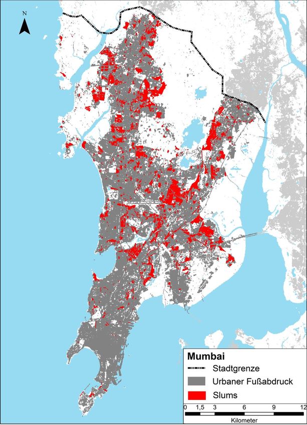
Why Do We Need Data Science and AI4EO?

                      •   data
                      •   research
                      •   services
                      •   applications

  user domain               information retrieval          observation systems

                                                    Image source: 1 , DELL
Data Science in Earth Observation for Social Good - Xiaoxiang Zhu - LRZ
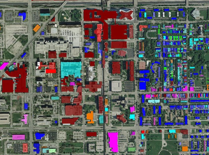
Model-Based Analytics
explorative signal processing methods

Data-driven Analytics
machine/deep learning methods
Data Science in Earth Observation for Social Good - Xiaoxiang Zhu - LRZ
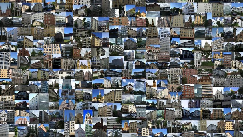
A Data Science Story – Global Urban Mapping
Data Science in Earth Observation for Social Good - Xiaoxiang Zhu - LRZ
Urban Planet

               [UN, 2014]
Data Science in Earth Observation for Social Good - Xiaoxiang Zhu - LRZ
Urban Growth Happens Mostly in Developing Areas

   Lagos, 21 Million Population
Data Science in Earth Observation for Social Good - Xiaoxiang Zhu - LRZ
10

State of the Art – Global Urban Footprint (GUF)

                GUF:   2D binary map urban vs. non-urban
11

So2Sat:
Big Data for 4D Global Urban Mapping – 1016 Bytes from Social Media to EO Satellites

               GUF:
               GUF:     2D binary map
                                  map urban
                                      urbanvs.
                                            vs.non-urban
                                               non-urban

               So2Sat: 3D/4D urban models
                       infrastructure type classification
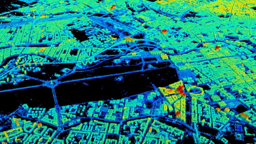
                       high resolution population density map
Methodology in a Nutshell – Big EO Data Fusion

                                                               Hyperspectral Sensor

        Radar Sensor

                                             Red Tile Roof

                                    Xiaoxiang Zhu                            Social Media Images
                                    @xiaoxiang_dlr

              Text Messages   I’m in the rooftop bar on 10th
                              floor. Last day in Rio de
                              Janeiro!         @Helmholtz
                              @DLR_de
10 Petabytes = half of the German Remote Sensing Data Archive
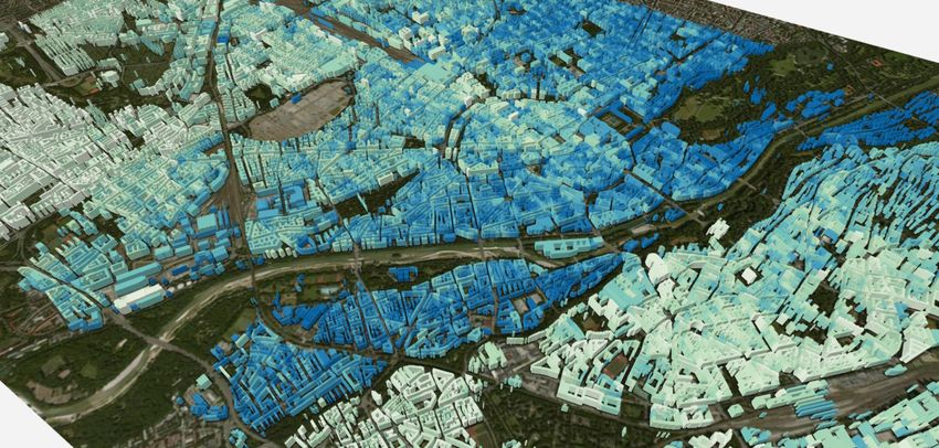
Global 3D/4D Urban Mapping

 TerraSAR-X / TanDEM-X
Radar Geometry in Range-Elevation Plane

                                          s

                            r
Radar Tomography – “X-Ray” of the Earth

                                          s

                            r
Why HPC?

TUM IGSSE Project @ LRZ – 4D City (SuperMUC)

Calculation for every single pixel = solving optimization
problem with a matrix dimension of ca. 102× 106

since 2012, 26mio CPU hours granted
ca. 1 million Pts/km2, 4D Information
+14

[mm]

-14

       Courtesy: S. Gernhardt, TUM
TanDEM-X for Global Coverage, But…
medium resolution , small number of images

TanDEM-X has global coverage, but …

 only moderate resolution

 number of coverages limited
Signal Processing Algorithms

       X-Ray of the Earth

                               Building heights
Deep Learning Algorithms
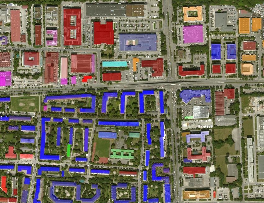
                               Building shapes
First Impression of the Global 3D Urban Models
Building Settlement Type Classification
– by the Fusion of Remote Sensing and Social Media Data

                                                          Social Media Images
Building Instance Classification from Street View Data by CNN
                                                                         apartment
                                                                         church
                                                                         garage
                                                                         house
                                                                         industrial
                                                                         office building
                                                                         retail
          Chicago                      Vancouver                Munich   roof
My Vision in 2022
A first and unique global and consistent 3D/4D spatial data set on the urban morphology
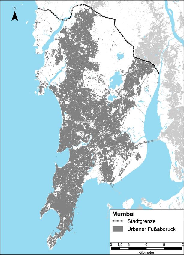
3D model vs. time

         Mumbai

                               Dharavi

 population density vs. time

                                         City boundary
                                         Urban Footprint

Courtesy: H. Taubenböck, DFD
The So2Sat Data will be Open

– better understanding and boosting research on the global change process of urbanization
– unique data set for stakeholders such as the United Nations
– a helping hand to address poverty

                    ERC Project @ LRZ – So2Sat (SuperMUC -NG)
                    Demand: > 100 mio CPU hours; >10 PB Storage
Data Volume (PB) in the German Satellite Data Archive D-SDA
               DFD Oberpfaffenhofen and Neustrelitz

                Today
FutureEO@ExtraMUC
                                                       Long Term
Use Cases:                                              Archives                                   User
– Sophisticated but expensive signal processing
                                                                                               Interface
  and AI algorithms
– Generation of regional to global scientific data               HDD/SSD
                                                                    Input                     CPU&GPU
– Time-critical processing and analysis
                                                                    Data
                                                                                              Processes
– External access to data and products                         > 150 PetaByte
                                                                    Output                 > 1.000.000 Cores
Requirements:                                                        Data

– Hybrid system powered with both CPUs and
  GPUs                                                                                                     ExtraMUC
                                                               Interfaces/Portals
– Large on-line memory
                                                                    > 100Gb/sec; DFN Kernnetzrouter
– Sufficient processor cores
– High-rate connection to DLR via DFN/GEANT          Hubs/                          User/Partner
                                                     Portals
FutureEO@ExtraMUC – Go Far Beyond Global Urban Mapping

We research and develop solutions for major challenges in the following areas …

Earth System Research and   Global Change Research     Meteorology                Sustainable Development
Environmental Sciences

Security                    Mobility                   Resource Management        City Planning
You can also read