DECONSTRUCTING FACTORS CONTRIBUTING TO THE 2018 FIRE WEATHER IN QUEENSLAND, AUSTRALIA - AMS
←
→
Page content transcription
If your browser does not render page correctly, please read the page content below
DECONSTRUCTING FACTORS CONTRIBUTING
       TO THE 2018 FIRE WEATHER IN QUEENSLAND, AUSTRALIA
                   Sophie C. Lewis, Stephanie A. P. Blake, Blair Trewin, Mitchell T. Black,
             Andrew J. Dowdy, Sarah E. Perkins-Kirkpatrick, Andrew D. King, and Jason J. Sharples

              Factors including the circulation pattern and antecedent conditions contributed to 2018
                   northeast Australian fires. High background temperatures also played a role
                           for which model evidence suggests an anthropogenic influence.

      EVENT DESCRIPTION AND STUDY AP-                                   “extreme” (FFDI ≥ 75) for large parts of Queensland
      PROACH. Significant wildfires occurred across                     and “catastrophic” (FFDI ≥ 100) in some locations.
      various regions in 2018. The 2018 bushfire season                 The FFDI includes a measure of fuel moisture content
      was declared early in many Australian jurisdictions.              calculated from antecedent rainfall and temperature,
      By 30 November 2018, 130 bushfires in Queensland,                 daily temperature, relative humidity (RH), and wind
      northern Australia, had caused significant damage                 speed (V). The 99th percentile FFDI (number of days
      and burned nearly 3/4 million hectares (see Aus-                  > 99th percentile) is discussed here as indicative of
      tralian Bureau of Meteorology 2018). Bushfires on                 the extreme end of the fire risk spectrum based on
      the scale of the 24 to 29 November event (hereafter               these weather conditions.
      simply called “the fires”) occurring in this coastal                  The 2018 fire occurred during a period of syn-
      Queensland location (see Fig. 1) were unprecedented.              optic- and large-scale extremes. This is typical of a
         The McArthur Forest Fire Danger Index (FFDI) is                compound extreme event (Zscheischler et al. 2018)
      used to assess dangerous bushfire weather conditions              and makes definition and analysis of the event as a
      in Australia (Noble et al. 1980). The FFDI increased              single variable limited. Prior research cautions that
      considerably in the last week of November and was                 direct attribution of the FFDI to specific forcings
      the highest on record (from 1950) in some areas.                  (e.g., anthropogenic greenhouse gases) is complicated
      During 24–29 November, daily FFDI values were                     by the index’s integration of multiple dependent
                                                                        variables (Black 2017). Model bias correction of one
                                                                        variable (e.g., temperature) requires its relationship
                                                                        with others (e.g., humidity) to be preserved. While
AFFILIATIONS: Lewis     and B lake —School of Science, University
                                                                        explicit examination of the FFDI may be possible with
of New South Wales, Canberra, Australian Capital Territory,
Australia; Trewin, B lack, and Dowdy—Bureau of Meteorology,
                                                                        multivariate bias correction (e.g., Cannon 2018), we
Melbourne, Victoria, Australia; Perkins-Kirkpatrick—Climate             adopt an alternative approach and instead examine
Change Research Centre, University of New South Wales,                  FFDI components separately. As individual variables
Sydney, New South Wales, Australia; King —School of Earth Sci-          have different weightings in the FFDI calculation
ences, The University of Melbourne, Parkville, Victoria, Australia;     and are affected by climate change differently (Black
Sharples –School of Science, University of New South Wales,             2017), it is valuable to examine each separately in
Canberra, Australian Capital Territory, and Bushfire and Natural
                                                                        order to determine the factors contributing to the
Hazards Cooperative Research Centre, Level 1, East Melbourne,
Victoria, Australia.
                                                                        extreme fire and heatwave period. We deconstruct
CORRESPONDING AUTHOR: Sophie C. Lewis, s.lewis@adfa.                    the observed key synoptic features during Novem-
edu.au                                                                  ber and the conditioning heatwave event (defined as
DOI:10.1175/BAMS-D-19-0144.1                                            24 to 29 November 2018, hereafter “the event”) and
                                                                        large-scale 2018 conditions [antecedent conditions
A supplement to this article is available online (10.1175/BAMS-
                                                                        in spring (September–November) and in November
D-19-0144.2)
                                                                        only, and large-scale modes of variability). Using
© 2019 American Meteorological Society                                  two climate model attribution [CMIP5 (Taylor et al.
For information regarding reuse of this content and general copyright
information, consult the AMS Copyright Policy.                          2012) and weather@home (Black et al. 2016)] frame-
                                                                        works, we examine whether aspects of these observed

      AMERICAN METEOROLOGICAL SOCIETY                                                                    JANUARY 2020        | S15
conditions were made more
likely due to anthropogenic
forcings.
O B S E RV E D L A RG E -
SC A LE FACTO R S .
We focus on the state of
Queensland and the region
of highest observed fire dan-
ger (hereafter “fire region”),
which encompasses the ma-
jor areas burnt.
Temperature. Observed dai-
ly maximum temperatures
(Tmax) were anomalously high
during November (Fig. 1b).
High Tmax and daily mini-
mum temperature (Tmin) were
persistent throughout the
event particularly for Tmin
(see Fig. ES1 in the online
supplement). Over this pe-
riod, Queensland area-av-
eraged minimum tempera-
tures are above the observed
95th percentile, and records
were broken in many loca-
tions (Australian Bureau Of
Meteorology 2018). Above-
average temperatures also
occurred in both regions
over spring and November.
Precipitation. Seasonal rain-
fall was below average over
the antecedent spring pe-
riod (Fig. 1c), which likely
favored drier soil moisture
conditions and increased
Tmax values (Kirono et al.
2017). While rainfall oc-
curred across the state in
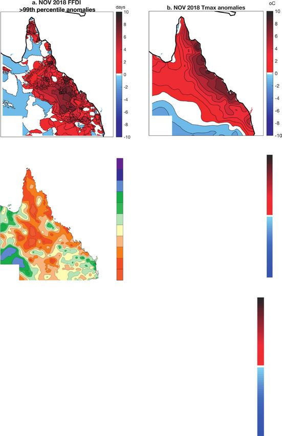
Fig . 1. Summary of key observed meteorological and climatological condi-
the days prior to the event
tions in Queensland state, northeastern Australia, during the November
2018 fire event. (a) FFDI anomaly (number of days for November 2018 > 99th (Fig. ES1c), the heatwave
percentile from 1950–2017 compared to long-term November average from event itself lacked significant
1950). (b) November 2018 average of daily Tmax anomalies (°C) (relative to rainfall. In the major fire-
long-term average from 1911). (c) Precipitation anomalies for SON (%) rela- affected regions, August to
tive to mean). (d) Wind speed (m s-1) and (e) direction, and (f) MSLP anoma- October is the driest period
lies (hPa) for the event (24–29 Nov, relative to long-term November mean of the year, and November
from 1979). Queensland state is shown, with area of interest for fire shown
marks the transition between
by dashed box, and the area of anomalously low MSLP in the Tasman Sea.
the dry and wet seasons; for
example, Mackay (northern
S16 | JANUARY 2020Table 1. Summary of observed 2018 meteorological and climatological conditions for Queensland and
large-scale indices. For the FFDI, the count of FFDI days above the 99th percentile is given for the fire
region for November, as are temperature and precipitation values for the fire region for 5-day periods
and the annual average large-scale index values. Maximum (or minimum) observed anomalies and
ranking of 2018 anomalies (relative to 1961–90) are indicated.
Maximum/minimum
Variable (QLD) 2018 anomaly anomaly Ranking
FFDI days > 99th 4 4 (2018) 1st since 1950
percentile (NOV)
Temperature (EVENT) 3.9°C 3.9°C (2018) 1st since 1950
Temperature (NOV) 1.65°C 2.8°C (2014) 4th since 1950
Precipitation (EVENT) –1.9 mm day−1 –2.1 mm day−1 (2006) 7th since 1950
Precipitation (SON) –0.2 mm day −1
–0.7 mm day (2002)
−1
31st since 1950
Index 2018 Maximum Anomaly Ranking
ENSO (ANN) 0.66 2.3 (2015) 13th since 1950
SAM (ANN) 2.4 2.4 (2018) 1st since 1950
IOD (ANN) 0.9 1.3 (1997) 2nd since 1950
point of fire region) averages 83 mm for the August– MSLP. Composited daily mean sea level pressure
October period and 88 mm for November. (MSLP) during the 5-day event shows a key low
pressure system over southeastern Australia and the
Large-scale context. The state of large-scale ocean– Tasman Sea (Fig. 1e), which was noted as a driver of
atmosphere modes of variability during 2018 are the anomalous southwest to westerly wind flow over
summarized in Table 1. Most notably, strong positive Queensland (Australian Bureau Of Meteorology
southern annular mode (SAM) and Indian Ocean 2018). We use the region of observed anomalously
dipole (IOD) conditions were observed; however, both low MSLP in the Tasman Sea (36°–42°S, 152°–162°E)
these modes are typically associated with rainfall to examine synoptic factors in model simulations.
variations over southern Australia, with minimal
impact in the north (Risbey et al. 2009; Ummenhofer Humidity. Relative humidity (at 2 m) observed during
et al. 2009; Hendon et al. 2016). El Niño–Southern the event was significantly below average, particularly
Oscillation (ENSO) conditions were largely neutral. for the coastal regions of Queensland (not shown).
We note that subseasonal drivers, particularly the
Madden–Julian Oscillation (MJO), were also influen- MODELED LARGE-SCALE CONTRIBUT-
tial during the fire event, with MJO-associated tropi- ING FACTORS. Background climatic conditions
cal cloud and rainfall bands likely contributing to the observed in 2018 are first examined using CMIP5
observed anomalous westward wind flow (Australian monthly and seasonal model data, with risk ratios
Bureau of Meteorology 2018). (RRs) associated with anthropogenic forcings calcu-
lated for exceeding 2018 observed anomalies for each
OBSERVED SYNOPTIC-SCALE FACTORS. variable (see section 2 in the online supplemental
Wind speed and direction. During the event, anoma- material). RRs are a quantification of the change in
lous westerly winds (at 10 m) were observed (Fig. 1d). the probability of an extreme that can be attributed
While wind speed was below the long-term November to anthropogenic forcings (e.g., an RR value of 2 in-
average for most of Queensland (except in coastal dicates a doubling of attributable risk).
southern Queensland), the westerly direction was
anomalous for this time of year, which usually experi- Temperature. Notable differences in the distribution
ences landward flow, with westerly winds reported at of temperatures in the fire region occur in CMIP5
some tropical coastal sites where they are historically experiments with different forcings (Fig. 2a), with
extremely rare in November (Australian Bureau of a substantial warm shift in temperatures in RCP8.5
Meteorology 2018). Anomalous wind features are simulations compared to historicalNat scenarios. The
hence both a risk factor and a key driver of tempera- shift in probabilities is particularly the case for warm
ture and humidity extremes. tail temperatures anomalies, consistent with previous
AMERICAN METEOROLOGICAL SOCIETY JANUARY 2020 | S17studies quantitatively attrib-
uting observed Australian
temperature extremes to
anthropogenic forcings (e.g.,
Black et al. 2015; Lewis and
Karoly 2013; Perkins and
Gibson 2015). The RR for
exceeding observed 2018 No-
vember temperature anoma-
lies is 4.5.
Precipitation. The distri-
but ions of a rea-average
Queensland September–
November (SON) rainfall
differ between the CMIP5
historicalNat and RCP8.5
simulations at the dry end
of the distribution (Fig. 2b;
see also Fig. ES2b). This in-
dicates that conditions drier
than average are simulated
to occur somewhat less often
under anthropogenically
forced runs (years 2005–36)
compared to natural runs.
The RR for rainfall deficits
lower than observed condi-
tions in spring 2018 is 1.5. We
note that observed regional
rainfa ll trends are wea k
and rainfall projections are
model dependent (Kirtman
et al. 2013), and attribution
of events may be spatiotem-
poral scale or definition de-
pendent (Angélil et al. 2017).
Fig . 2. Summary of modeled conditions in Queensland. Plot shows com- MODELED SYNOPTIC-
parison of CMIP5 historicalNat (blue), historical (black), and RCP8.5 (red) SCALE CONTRIBUT-
experiments for (a) daily fire region area-averaged November temperature ING FACTORS. We next
(°C) probability distributions and (b) Queensland (QLD) area-average SON explore synoptic-scale fac-
precipitation (mm day−1) cumulative distributions for anomalies relative to tors in a large single-model
each model’s 1961–90 climatology, with 2018 observed anomalies noted by a
ensemble of atmosphere-only
vertical dashed line. For the weather@home ensemble, plots shows (c) anoma-
lies (ALL − NAT) of 5-day running mean MSLP(hPa) with stipples showing simulations [weather@home;
anomalies larger than the standard deviation of daily November values. PDFs see Black et al. (2016) and sec-
are given for weather@home (d) daily November MSLP conditions in Tas- tion 3 of our online supple-
man region for ALL (red) and NAT (blue), (e) daily fire region area-averaged mental material). The fires
November temperature (°C), and QLD area-average (f) precipitation (mm were characterized by a dis-
day−1) and (g) relative humidity (%). For weather@home plots, dashed lines tinct synoptic evolution over
show distributions of variables during times only when 5-day running mean
the 5-day period beginning
MSLP in the Tasman Sea box is below the 10th percentile of all days.
24 November and notably
low MSLP in the Tasman Sea.
S18 | JANUARY 2020MSLP. We compare the occurrence of low area-average MSLPLOW. While CMIP5 analysis indicated ante-
MSLP anomalies in the Tasman region (Fig. 1e) be- cedent rainfall deficits were more likely under green-
tween the experiments conducted with present-day house gas forcings, low daily rainfall in Queensland
atmospheric composition (ALL) and preindustrial does not have a discernible anthropogenic influence
atmospheric composition and composite surface field (Fig. 2f), although we note that persistent low daily
modified by removing different anthropogenic rainfall or consecutive dry day indices were not ex-
response pattern estimates (NAT). There are no amined.
significant changes in 5-day mean November daily
MSLP patterns in these scenarios (Fig. 2c) and the Humidity. There was little notable difference simulated
daily area-average Tasman Sea MSLP distributions between daily November conditions in the ALL and
are indistinguishable between experiments (Fig. 2d). NAT scenarios for humidity (Fig. 2g), although low
daily humidity values in Queensland are more likely
Temperature. There is a clear warm shift in November for MSLPLOW.
daily temperatures in both the fire region (Fig. 2e)
and QLD (Fig. ES2a) in the ALL forcing simulations. SUMMARY. We have provided a qualitative ex-
There is an additional contribution to warm simulat- amination of the extreme fire and heatwave event
ed temperatures from prevailing low MSLP patterns. of November 2018 in Queensland by deconstructing
When daily temperature anomalies in the fire region various contributing factors. As the FFDI measure
are compared for all simulated with those where area- combines multiple, interdependent variables, we
average Tasman region MSLP anomalies are below explored components separately in observations
the 10th percentile value of all values (MSLPLOW), and climate models (summarized in Table 2). The
a further warm shift in temperatures occurs. fires (and conditioning heatwave) were a complex
compound extreme event with multiple contribut-
Precipitation. For daily area-average Queensland, low ing factors occurring on a range of spatiotemporal
precipitation values in November are most likely in scales. The high 2018 November temperatures and
the NAT simulations and particularly days sorted by low antecedent spring rainfall in Queensland were
Table 2. Summary of (i) observed 2018 meteorological and climatological conditions, (ii) assessment of
their influence (higher/lower) on the extreme observed FFDI during November and the event, (iii) as-
sessment of whether these were conditions were lower, higher, or the same in weather@home simula-
tions during low Tasman Sea MSLP occurrences, and (iv) assessment of whether observed conditions
are altered by simulated anthropogenic forcings influences (higher/lower or same probability with and
without anthropogenic forcings, or N/A for not assessed) in CMIP5 [where the risk ratio (RR) is provid-
ed] and weather@home (where qualitative assessment is made).
(ii) Contribution to (iv) Lower/
(i) 2018 anomaly FFDI (iii) Lower/higher/ higher/same with
(relative to (lower or higher same with low anthropogenic
Variable climatology) FFDI) Tasman MSLP GHG
FIRE temperature
(NOV) H H H H (RR = 4.5)
FIRE temperature
(EVENT) H H H H
QLD precipitation
(SON) L H N/A L (RR = 1.5)
QLD precipitation
(NOV) L H L L
QLD humidity
(EVENT) L H L S
Tasman MSLP
(EVENT) L H S
QLD/FIRE L (and westerly
WINDS (EVENT) direction) H N/A N/A
AMERICAN METEOROLOGICAL SOCIETY JANUARY 2020 | S19key contributors to the elevated fire risk, in addition low pressure systems to the south and westerly wind
to the evolution of synoptic conditions that resulted flow, but were not accompanied by compound bush-
in low humidity and anomalous westerly winds. fires in northern or central Queensland (Australian
Sustained low rainfall and extreme high tempera- Bureau of Meteorology 2018). The 2018 conditioning
tures were notable antecedent conditions prior to the heatwave event was more severe and persistent than
event, and these large-scale factors, in particular, are previous analogs, with no event of this scale previ-
thought to result in increased availability of larger fuel ously occurring at such northerly coastal locations.
elements, which can lead to increases in fire intensity Events that are unprecedented in a given region, such
and energy release from a fire (Sharples et al. 2016). as the 2018 event, reveal that firefighting prepara-
Both CMIP5 and weather@home model datasets tion and training cannot rely on previous events as
indicate that anthropogenic forcings in model simu- guidance for the most dangerous conditions they can
lations increase the likelihood of higher Queensland expect in the current and future climate in which
and fire region temperatures. CMIP5 models also large-scale fires occur more regularly. This demon-
provide some evidence of increased likelihood of strates that providing information to regions with
dry spring conditions with enhanced anthropogenic developing future risk of extreme or catastrophic
greenhouse gases. The large-scale ocean–atmosphere FFDI measures, or with enhanced risk outside the
modes of climate variability that were anomalously historical fire season, is of critical importance.
positive in 2018 (IOD and SAM) do not typically Future exhaustive examinations of fire events
influence northern Australian climates, although should additionally consider the evolution of syn-
negative SAM is strongly correlated with high FFDI optic conditions during the event, the accumulated
in southern Australia. antecedent rainfall and soil moisture deficits, the
As with all short-duration extremes, the evolution weighting of these variables in indices such as the
of synoptic conditions was critical to the fire event. FFDI, and the ability of models to simulate each vari-
These conditions included a significantly late start able for the region and season in question. Under this
to the wet season, a sustained low pressure system comprehensive framework, quantitative attribution
to the south of the state, and unusual westerly wind statements may provide insight.
flow. These conditions occurred in conjunction with
a severe and persistent heatwave (high minimum ACKNOWLEDGMENTS. S.C.L (DE160100092),
and maximum temperatures) and very low humid- S.E.P.-K. (FT170100106), A.D.K (DE180100638), and J.J.S.
ity, leading to FFDI measures of “extreme” or “cata- (IN140100011, IN160100029) are funded through the
strophic” over much of Queensland. This synoptic Australian Research Council. A.J.D. is funded through
pattern was not shown to be more likely in ALL forc- the Australian Government’s National Environmental
ings simulations of weather@home as diagnosed by Science Program.
low MSLP conditions in the Tasman Sea. MSLPLOW
days in weather@home were associated with warmer
temperatures and low humidity in Queensland. REFERENCES
Angélil, O., D. Stone, M. Wehner, C. J. Paciorek,
FUTURE CLIMATE RISKS. Although complex H. Krishnan, and W. Collins, 2017: An independent
events are challenging to understand, attempts to assessment of anthropogenic attribution statements
evaluate possible changes in future fire danger in for recent extreme temperature and rainfall events.
eastern Australia are critical for adaption. While we J. Climate, 30, 5–16, https://doi.org/10.1175/JCLI-
have not provided a quantitative extreme event attri- D-16-0077.1.
bution assessment of this event, ours is one of many Australian Bureau of Meteorology, 2018: Special Climate
results that points to increasing fire danger risks in Statement 67—An extreme heatwave on the tropical
eastern Australia. In Australia, an overall increase Queensland coast. Bureau of Meteorology, 30 pp.,
in the FFDI has been observed in many regions, http://www.bom.gov.au/climate/current/statements/
particularly for southern and eastern Australia in scs67.pdf.
recent decades (Dowdy 2018), with future projections Black, M. T., 2017: An attribution study of southeast
clearly showing an increase in the FFDI throughout Australian wildfire risk. Ph.D. thesis, Univer-
Australia based on a comprehensive set of modeling sity of Melbourne, 179 pp., http://hdl.handle.
approaches (Dowdy et al. 2019). net/11343/123669.
Previous notable heatwave events in the region in —, D. J. Karoly, and A. D. King, 2015: The contribu-
1995, 1994, and 1969 were also associated with strong tion of anthropogenic forcing to the Adelaide and
S20 | JANUARY 2020Melbourne, Australia, heat waves of January 2014 [in Lewis, S. C., and D. J. Karoly, 2013: Anthropogenic con- “Explaining Extreme Events of 2014 from a Climate tributions to Australia’s record summer temperatures Perspective”]. Bull. Amer. Meteor. Soc., 96 (12), S145– of 2013. Geophys. Res. Lett., 40, 3705–3709, https:// S148 , https://doi.org/10.1175/BAMS-D-15-00097.1. doi.org/10.1002/grl.50673. —, and Coauthors, 2016: The weather@home regional Noble, I. R., A. M. Gill, and G. A. V. Barry, 1980: climate modelling project for Australia and New McArthur’s f ire-danger meters expressed as Zealand. Geosci. Model Dev., 9, 3161–3176, https:// equations. Aust. J. Ecol., 5, 201–203, https://doi. doi.org/10.5194/gmd-9-3161-2016. org/10.1111/j.1442-9993.1980.tb01243.x. Cannon, A. J., 2018: Multivariate quantile mapping bias Perkins, S. E., and P. B. Gibson, 2015: Increased risk of correction: An N-dimensional probability density the 2014 Australian May heatwave due to anthropo- function transform for climate model simulations of genic activity [in “Explaining Extreme Events of 2014 multiple variables. Climate Dyn., 50, 31–49, https:// from a Climate Perspective”]. Bull. Amer. Meteor. doi.org/10.1007/S00382-017-3580-6. Soc., 96 (12), S154–S157, https://doi.org/10.1175/ Dowdy, A. J., 2018: Climatological variability of fire BAMS-D-15-00074.1. weather in Australia. J. Appl. Meteor. Climatol., 57, R isbey, J. S., M. J. Pook, P. C. McIntosh, M. C. 221–234, https://doi.org/10.1175/JAMC-D-17-0167.1. Wheeler, and H. H. Hendon, 2009: On the re- —, H. Ye, A. Pepler, M. Thatcher, S. L. Osbrough, J. P. mote drivers of rainfall variability in Australia. Evans, G. Di Virgilio, and N. McCarthy, 2019: Future Mon. Wea. Rev., 137, 3233–3253, https://doi. changes in extreme weather and pyroconvection risk org/10.1175/2009MWR2861.1. factors for Australian wildfires. Sci. Rep., 9, 10073, Sharples, J. J., and Coauthors, 2016: Natural hazards in https://doi.org/10.1038/s41598-019-46362-x. Australia: Extreme bushfire. Climatic Change, 139, Hendon, H. H., D. W. J. Thompson, and M. C. Wheeler, 85–99, https://doi.org/10.1007/s10584-016-1811-1. 2016: Australian rainfall and surface temperature Taylor, K. E., R. J. Stouffer, and G. A. Meehl, 2012: An variations associated with the Southern Hemisphere overview of CMIP5 and the experiment design. annular mode. J. Climate, 20, 2452–2467, https://doi. Bull. Amer. Meteor. Soc., 93, 485–498, https://doi. org/10.1175/JCLI4134.1. org/10.1175/BAMS-D-11-00094.1. Kirono, D. G. C., K. J. Hennessy, and M. R. Grose, 2017: Ummenhofer, C. C., M. H. England, P. C. Mclntosh, Increasing risk of months with low rainfall and high G. A. Meyers, M. J. Pook, J. S. Risbey, A. Sen Gupta, temperature in southeast Australia for the past 150 and A. S. Taschetto, 2009: What causes southeast years. Climate Risk Manage., 16, 10–21, https://doi. Australia’s worst droughts? Geophys. Res. Lett., 36, org/10.1016/j.crm.2017.04.001. L04706, https://doi.org/10.1029/2008GL036801. Kirtman, B., and Coauthors, 2013: Near-term climate Zscheischler, J., and Coauthors, 2018: Future climate change: Projections and predictability. Climate risk from compound events. Nat. Climate Change, Change 2013: The Physical Science Basis. T. F. Stocker 8, 469–477, https://doi.org/10.1038/s41558-018- et al., Eds., Cambridge University Press, 953–1028. 0156-3. AMERICAN METEOROLOGICAL SOCIETY JANUARY 2020 | S21
You can also read