Deliverable D.T1.2.1 Short version - Use Case Definition (short report) - Alpine Space
←
→
Page content transcription
If your browser does not render page correctly, please read the page content below
Deliverable D.T1.2.1
Short version
Use Case Definition (short report)

Version: 3.0

Dissemination level: Public

WP: WP T1 Ex-ante analysis and development of methods for pilot service

Author: AustriaTech (ATE)

Date: 14.09.2020

                                                     http://www.alpine-space.eu/linkingalps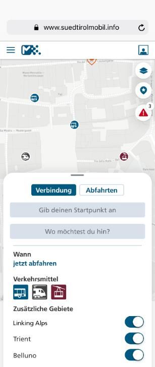
Document Information

Authors

                      Name                         PartnerNo                      Organisation
              Bettina Neuhäuser               1                          ATE
              Katharina Helfert               1                          ATE
              Bernhard Monschiebl             1                          ATE
              Michael Zangl                   1                          ATE
              Daniela Gamper                  1                          ATE
              Matthias Günther                12                         SBB

Peer-Reviewer

                      Name                         PartnerNo                      Organisation
              Andreas Partusch                5                           VAO

Document History

                 Date                     Version                              Dissemination
              13.01.2020                     V0                   -
              20.01.2020                    V0.1                  -
              21.01.2020                    V0.2                  -
              22.01.2020                    V0.3                  Project partners
              10.02.2020                    V0.4                  Project partners
              17.06.2020                    V0.5                  Project partners
              27.08.2020                    V1.0                  Project partners
              08.09.2020                    V2.0                  Project partners
              14.09.2020                    V3.0                  Project partners
              14.09.2020            V3.0_short_version            Project partners

LinkingAlps                   D.T1.2.1 – Use case definition (short report)                      2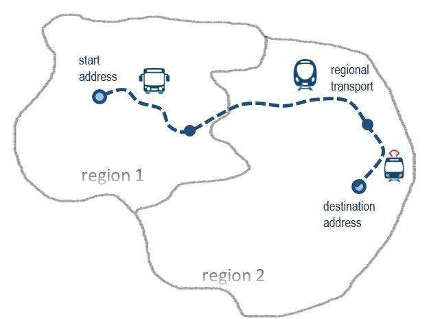
Preface

Acronym:              LinkingAlps

Title:                Innovative tools and strategies for linking mobility information services
                      in a decarbonised Alpine Space

Project number:       740

Start Date:           01-10-2019

End Date:             31-06-2021

Call number:          4th call

Priority:             Priority 2 - Low Carbon Alpine Space

Specific objective:   SO2.2 - Increase options for low carbon mobility and transport

LinkingAlps                 D.T1.2.1 – Use case definition (short report)                         3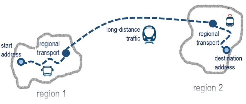
Abbreviations

    Abbreviation                                 Definition

 ATE               AUSTRIATECH

 AEV               Transport and Energy agency Canton Grison

 ARIA              Regional Agency for Innovation and Purchasing Ltd

                   Consulting company for control, information and computer technology
 BLIC
                   GmbH
                   Centre d’Etudes et d’expertise sur les Risques, l’Environnement, la Mobilité
 Cerema            et l’Aménagement - Centre For Studies and Expertise on Risks, Environment,
                   Mobility, and Urban and Country planning

 CMTo              Metropolitan City of Turin

 FoT               Federal Office of Transport

 LINKS             LINKS Foundation - Leading Innovation & Knowledge for Society

 NAP               National Access Point

 RRA-LUR           Regional Development Agency of the Ljubljana Urban Region

 SBB               SBB Swiss Federal Railways

 STA               South Tyrolean Transport Structures

 UM-FGPA           University of Maribor

 VAO               Traffic Information Austria

 VTG               Verkehrsverbund Tirol GesmbH

LinkingAlps             D.T1.2.1 – Use case definition (short report)                             4
Active system       The active system integrates the routing information from several local
                     journey planners to a combined seamless route. It is composed of a passive
                     system and a Distributing system. It communicates through an OJP interface.
                     It's a journey planning engine with OJP capabilities. Via the distributing
                     system it is able to detect journeys through adjacent or remote regions and
                     able to create OJP Trip Composition (alias OJP Router).

 Adjacent region     Region which is adjacent to the local region and has its own "local" journey
                     planning systems.
 Adjacent system     Alias for neighboring system; participating System of an adjacent region.
 Distributing        System that distributes journey planning enquiries to other
 system              systems. It sends the request for journey-parts through areas to the
                     corresponding passive servers, receives the responses and is able to create
                     OJP Trip Compositions. It has the knowledge about gazetteers and is able to
                     collect information about exchange points for the whole system.
 End user            User of an "end user application". It is a person asking for journey planning
                     information by using an end user application. It is the enquirer of a journey
                     plan with a start, an end point and some travel preferences.
 End user            It is the application used by the end user to have access to JP information
 application         generated by the Distributed Journey Planning Service (DRJP). It can be a
 (synonymously for   third party application connecting by OJP interface to a Participating system
 ‘End user           or the User Interface participating system. The provider of the end user
 application’)       applications are the, so called, “OJP users” in the LinkingAlps project.
 Enquierer           The end user asking for information.
 Enquirer system     Alias home system.
 Estimated data      A predicted arrival or departure time of a particular means of transport at a
                     particular stop. In case of real time data it can change several times during
                     the journey.
 Exchange point      Stop or stations where the trip leg of one system is connected to the trunk
                     leg of another system. This includes regional stops which match with stops
                     for long distance or regional stops from adjacent regions. Exchange points
                     are mainly but not exclusively located at borders and in bigger cities.
 Exchange point      A repository, a view on a database or a service that is able to list the
 data base           relevant exchange points of the distributed service. It can be a static system-
                     wide database or be generated dynamically with requests for exchange
                     points to the responding services.
 Gazetteer           directory of common objects across the local journey planner systems and
                     its system borders. It enables the active system to find the passive system
                     for all geolocations (stops, stations, POIs, address etc.). The gazetteer acts
                     system-wide.
 Home system         The Participating system called by the end user application. It is the system
                     that take care of the end user travel information request and provide an
                     answer.

LinkingAlps               D.T1.2.1 – Use case definition (short report)                                5
Journey A movement of a traveller from a start point to an end point by using one or
more transport modes.
Journey Planner A system that is calculating the journey for a given request. It is able to
(JP) accept requests directly from end-user services. It is a generalization of OJP
Router and OJP responder.
Journey Planning Alias for Journey Planner.
System (JPS)
Local Journey A system with a routing engine and access to multimodal data with a
Planner (LJP) particular local, regional or national coverage; “local” underlines its focus on
a specific coverage that is limited. LJPs have no transregional (or distributed)
OJP routing capabilities.
Local region The territory covered the journey planner / home-system, which can plan
trips itself without information from other systems.
Long distance Crosscountry interchange. Supported by trains and crosscountry travelling
traffic coaches.
Long distance The trunk legs of the routes that connect at least 2 OJP systems. They are
transport used to connect two neighboring or remote systems. Exchange points are
connection defined along the trunk leg which define all the neighboring systems.
Neighbouring Alias for adjacent system.
system
OJP Implementer Travel information service provider that is implementing an OJP service
exchange (in most cases on the back-end system of an end user service).
OJP Interface Application Programming Interface (API) based on CEN/TS 2017: OpenAPI
for distributed journey planning and specified in D.T1.5.1 Specification of the
API interface (including a LinkingAlps OJP Profile).
OJP Responder Alias for passive system.
OJP Router Alias for active System.
OJP User End-user service provider that is using OJP services from local JPs to provide
an end-user service
Open Journey Standard for communication for distributed journey planning.(CEN/TS
Planning (OJP) 17118:2017)
Participating A local journey planner being part of the OJP system architecture and the
system appropriate OJP service
Passive system A Local journey planner (LJP) with a OJP interface (API) being able to
respond to requests from distributing systems. It is an information source
within the system without distributed journey planning capabilities. It
communicates through an OJP interface as a responding system.
alias OJP responder, responding system.
Public transport Service that allows people to travel. The service is for public usage.
services
Real time data The real time of a particular means of transport at a particular stop; only
sent after the arrival/depature of the vehicle at a particular stop.
LinkingAlps D.T1.2.1 – Use case definition (short report) 6Remote region Region which is not adjacent to the local region. A remote region is covered
by a local LJP.
Remote system Participating system of a remote region .
Responding The generalized term for a system that responds to questions from the
system distributing system
Schedule data planned data for public transport services
Server Program that provides special services that can be used by other programs.
Service Technical, self-sufficient unit that bundles related functionalities into a
complex of topics and makes them available via a clearly defined interface.
System Delimitable "structure" consisting of various components which can be
regarded as a common whole due to certain ordered relationships between
them.
Trip Alias Journey.
Trip leg The local part of a trip which is calculated by a single Local Journey planning
system.
Trunk leg The “trunk” leg are long-distance transport connections that interlink
Journey planning systems
Linking Alps Is a network of existing local, regional or national travel information services
Distributed (routing platforms) that collaborate on the basis of CEN OJP exchange
Journey Planning interface (CEN/TS 2017: openAPI for distributed journey planning) in order
Service (DRJP) to exchange travel information and routing results. A web-based
communication network between the participating systems needs to be
established as the systems are physically remote. A universal common
interface for exchanging requests between the participating services needs
to be specified and implemented at all participating systems.
OJP Profile The LinkingAlps OJP Profile aims to define a specific subset of (XML) data
elements following a clearly arranged structure in accordance with the OJP
standard (CEN/TS 17118:2017) and defined using XML schemas. The
schemas include all functionalities required for an OJP interface in order to
enable communication with the LinkingAlps distributed journey planning
system. In this sense the LinkingAlps OJP Profile defines the content and the
structure of the information content as well as the physical exchange
format.
LinkingAlps D.T1.2.1 – Use case definition (short report) 7Table of Contents
1 Introduction........................................................................................................................ 10
1.1 Scope of the report ............................................................................................................... 10
1.2 Focus on end user services .................................................................................................... 10
1.3 End user expectations ........................................................................................................... 10
2 Use case details .................................................................................................................. 12
2.1 Content of use cases ............................................................................................................. 12
2.2 Use case 1: Short distance..................................................................................................... 13
2.3 Use case 2: Long distance ...................................................................................................... 15
3 Possible end-user applications for LinkingAlps demonstration.............................................. 17
3.1 LinkingAlps as part of the mobility portal südtirolmobil of STA - Bozen ............................... 17
3.2 Illustrations of the mobility portal südtirolmobil of STA - Bozen .......................................... 18
4 Outlook .............................................................................................................................. 19
4.1 Link to relevant target groups ............................................................................................... 19
4.2 Relevance for technical use cases (demonstration and evaluation) ..................................... 19
LinkingAlps D.T1.2.1 – Use case definition (short report) 8Table of figures Figure 1: Short distance use case (UC1) ................................................................................................ 14 Figure 3: Long distance use case (UC2) ................................................................................................. 16 Figure 3: Illustration of the südtirolmobil end user web application.................................................... 18 Figure 4: Illustrations of the südtirolmobil end user mobile application .............................................. 18 Table of tables Table 1: Use case 1 – Short distance ..................................................................................................... 15 Table 2: Use case 2 - Long distance ....................................................................................................... 16 LinkingAlps D.T1.2.1 – Use case definition (short report) 9
1         Introduction
    1.1       Scope of the report

This report describes the main use cases of LinkingAlps with regard to the application of the
Linking Alps Distributed Journey Planning Service (DRJP). The two main use cases (short distance
travel and long distance travel) both cover different scenarios that provide the basis for
demonstrating cross-border and transnational (multi-region) linking of services in the Alpine
region. The defined scenarios provide the basis for end user application tests performed in the
course of the demonstration and evaluation activities in WP T2. The use cases are designed such
as the needs of travellers, tourists and commuters as the main target group, are well reflected
in the description of the scenarios and in a way that it is possible to evaluate functionality and
quality aspects towards the end-user of the DRJP. The use cases also need to take into account
the objective of the Alpine Space Programme and its expectations towards the project.
Therefore, the use cases should be in line with the description of Output O.T2.1., a transnational
service based on distributed OJP services.

    1.2       Focus on end user services

The project is primarily working on the back-end side of a decentralised travel information
system, i.e. the OJP services. Nevertheless, the OJP services need to be integrated into an end
user application in order to merge the information from the various sources and integrate it into
a seamless journey plan or journey plan update. An integration of the OJP services is foreseen
at the active systems.

While the system architecture is looking at the technical model of the decentralised service,
defining the system parts, roles and responsibilities/functionalities, the use cases shall define
the end product (output) from an end user perspective.

Nevertheless, the specified use cases should also provide relevant information to steer the
technical developments and the development of the service architecture and should provide a
reference for the evaluation in the pilot. Regarding the latter, required functionality purposes
from an end user perspective should be covered as well. In order to provide a basis for this
evaluation, it is important to understand how the information flow works.

    1.3       End user expectations
This chapter emphasizes on typical expectations of an end user who is considered using an end
user service that is able to request and provide information to and from the DRJP system. It

LinkingAlps                  D.T1.2.1 – Use case definition (short report)                           10
should be noted that the following criteria rather provide a comprehensive overview than a
detailed list of requirements a DRJP enabling end user service should be capable of.
The end user of a LinkingAlps end user service is expecting the provision of a seamless,
transnational routing result from an indicated origin point to a desired destination of a trip,
which is based on multimodal travel options.
The end user is expecting to be able to adjust and fine-tune the route characteristics via selection
criteria, which cover:
Travel options (modes)
Departure and/or arrival time
Trip characteristics (e.g. fastest, shortest)
Number of changes and time of stop overs
Accessibility
Luggage and carry on items (e.g. over-sized luggage, sport equipment, wheel chair)
The end user should be able to input the origin point and the desired destination either as:
Point at the map (coordinates)
Postal addresses
Point of interest (e.g. hotel, sight)
Stops
The provided route is expected to be illustrated on a map for the end user to navigate (minimum)
and is expected to be optionally supported by a detailed list of route information (e.g. names of
stops, exchange points) (optimum).
Incidents and delays on the provided route are expected to be communicated to the end user.
This service can either be provided via updated, real-time information services, highlighting
delays and obstructions along the route (minimum) or by providing the end user with
notifications of delays or obstructions (optimum) and adjusted route suggestions.
In accordance with the project goal to raise awareness of low-carbon mobility solutions, the end
user would like to receive information on the carbon foot print of the trip (e.g. emission balance).
The language of the provided end user application is expected to be in the administrative
language(s) of the home systems and in English.
LinkingAlps D.T1.2.1 – Use case definition (short report) 11The calculated route is also expected to be available offline.
End users who are using an end user application mainly for touristic purposes expect an end
user application to provide information on:
POIs along the route (e.g. sights, landmarks)
Service facilities (e.g. public toilets, ATMs, touristic info points / centres)
Ticketing
To highlight the transnational character of the route service, end users are provided the
possibility to receive a notification when crossing borders between countries (selection criteria).
End users who are using the application mainly for commuting expect the app to offer the
possibility to save frequently enquired / the last routes.
2 Use case details
2.1 Content of use cases
Use cases are defined by the following aspects:
Title
Identifier
Goal of the use case
Description
Actors
Covered information and data
Process flow
Scenarios1
1
The full version of Deliverable D.T1.2.1 further specifies use case specific scenarios in more detail.
LinkingAlps D.T1.2.1 – Use case definition (short report) 122.2 Use case 1: Short distance
Title Short distance (linking two different journey planners)
Identifier UC1
Linking of services between two different regions covering short distance journey
Goal
planning to show a typical commuting routing service.
With Use Case (UC1), Linking Alps will show the basic functionality of its "Linking of
Services" approach from the different service providers. UC1 will demonstrate routing
over two neighboring regions. The regions in this context are service areas of a
transport association or of a tariff association.
UC1 will allow an end-user application to connect to one of the service providers
routing engines offering not only routing within this one single region but also offering
interregional routing between different regions. This allows end user applications to
extend a traveller information service to neighboring Linking Alps areas by connecting
Description to just one routing engine of the Linking Alps service providers.
The solution offers multimodal public transport information with real time
information if available. Nevertheless, it will still keep functionality if only static
information is available for some reason for parts of the journey or the complete
journey.
Since UC1 focuses on short distance journeys, its target group will be travellers which
are assumed to be more knowledgeable of the different public transport options and
routes but maybe want to know more traffic information before or during the journey
to adapt their route accordingly.
LinkingAlps D.T1.2.1 – Use case definition (short report) 13Figure 1: Short distance use case (UC1)
End user application(s)
Two different journey planners (at least one active system and another
Actors
active or passive system) - Journey planners from SBB, STA, VAO, ARIA, CMTo
or LUR)
Mandatory:
Travel modes supported
o Public transport e.g.: train, bus, tram, underground, etc.
o Walking
Multimodal routes (door-to-door)
Planned departure and arrival times (static data)
Transport operator
Covered
Changes (location of the changes)
information
Number of changes and time of stop overs (static data)
and data
Optional:
Actual departure and arrival times (real-time data)
Actual number of changes (location information) and time of stop overs
(real-time data)
Accessibility information for special needs user
Luggage and carry on items (e.g.: wheelchair carriage)
LinkingAlps D.T1.2.1 – Use case definition (short report) 14Scenario 1.1: Real time routing: Routing with real time information for every trip leg
available.
Scenario 1.2: Static routing: Routing when only static information is available for at
Scenarios least one trip leg.
Scenario 1.3: Cross-border walking route between two exchange points Routing
Gap: Routing demonstrating the crossing of regional borders with a short walking
distance between PT trip legs.
Table 1: Use case 1 – Short distance
2.3 Use case 2: Long distance
Long distance (linking a minimum of two journey planners with a long-distance
Title
routing option in-between)
Identifier UC2
Linking of services between two different regions covering long distance journey
Goal
planning to show a typical tourist routing service.
UC2 will demonstrate routing over two or more regions with long-distance travel
routes included. The regions in this context are service areas of a transport association
or of a tariff association.
UC2 will allow an end user application to connect to one of the service providers
routing engines offering not only routing within this one single region but also offering
interregional routing between different regions. This allows end user applications to
extend the traveller information service to the complete Linking Alps areas by
Description
connecting to just one routing engine of the Linking Alps service providers. The
solution offers multimodal public transport information based on static data.
UC2 focuses on long-distance journeys and its target group will be travellers (primarily
tourists), which are assumed to use the service via the end-user application mainly
four touristic purposes for planning long-distance journeys to regions abroad some
time in advance of a trip.
LinkingAlps D.T1.2.1 – Use case definition (short report) 15Figure 2: Long distance use case (UC2)
End user application(s)
At least two different journey planners (at least one active system and other
Actors
active or passive systems)
Journey planners from SBB, STA, VAO, ARIA, CMTo or LUR
Mandatory:
Travel modes supported
o Public transport e.g.: train, bus, tram, underground
o Walking
Multimodal routes (door-to-door)
Covered Planned departure and arrival times (static data)
information Transport operator
and data Changes (location of the changes)
Number of changes and time of stop overs (static data)
Optional:
Accessibility information
Luggage and carry on items (wheelchair carriage)
Scenario 2.1: Two-part long-distance journey planning: Linking of two journey
Scenarios planners including long-distance routing
Scenario 2.2: Multi journey planning: Minimum of three journey planners involved
Table 2: Use case 2 - Long distance
LinkingAlps D.T1.2.1 – Use case definition (short report) 163 Possible end-user applications for LinkingAlps
demonstration
Associated to the use cases defined in this report, the LinkingAlps project partners work on the
provision of end user applications. The active systems of the DRJP are working on the integration of
information from all OJP services. At least one system is expected to further provide an interface to
an end user service, either via their own journey planners or also via third-party services and
applications. The following chapter provides information of a planned end user service, with the intent
to make the DRJP available to the end user through applications for both web and mobile devices.
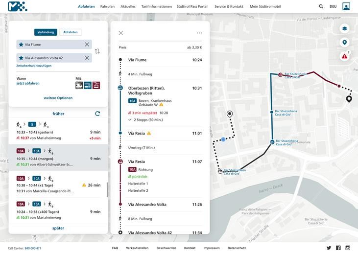
3.1 LinkingAlps as part of the mobility portal südtirolmobil of STA - Bozen
A goal of a distributed routing systems is to make cross-border routing available to end users via
various journey planners. In the case of STA - Bozen for the South Tyrol area, a distributing system
developed in the LinkingAlps project, processes and makes available timetable information from other
partner systems through an OJP interface developed in LinkingAlps. While enriching the service from
STA Bozen with the information from other systems, the data quality standard of the information in
the regional area, i.e. in South Tyrol, which the end user is "accustomed" to, should be maintained.
In terms of the end user GUI, a first idea was to activate the LinkingAlps service area with a checkbox:
If the checkbox is OFF, the currently used EFA API will be requested, as before. If the checkbox is ON,
the OJP interface will be requested. The rest of the GUI should remain the same for the user. So the
end user actually does not notice anything. Possibly there will be a hint text, which describes the
function of these switches.
The screenshots below show first drafts of the new mobility portal suedtirolmobil.info, which was
successfully released on August 26, 2020. Updates, improvements and new features will follow
constantly. This includes the OJP interface integration.
LinkingAlps D.T1.2.1 – Use case definition (short report) 173.2 Illustrations of the mobility portal südtirolmobil of STA - Bozen
Figure 3: Illustration of the südtirolmobil end user web application
Figure 4: Illustrations of the südtirolmobil end user mobile application
LinkingAlps D.T1.2.1 – Use case definition (short report) 184 Outlook
4.1 Link to relevant target groups
The presented use cases and scenarios illustrate the principal routing possibilities offered by a
capable DRJP end user service via an application (e.g. web service, mobile app).
End users who are using such an application are considered primarily to be provided with traffic
and traveller information for touristic (Tourists) or commuting (Commuters) purposes.
Tourists expectations are reflected primarily by the two scenarios defined in use case UC2 - Long
Distance. This use case highlights the transnational character of a DRJP end user service by
providing the possibility of requesting multimodal door-to-door routing across the alpine region
via a single service - not only between bordering regions, but also on an international scale and
over longer distances, which are usually requested by tourists of any kind. This service
encourages touristic travellers to shift their demand towards sustainable and low-carbon
mobility options, especially when travelling cross-border (regional and national) for touristic
purposes.
Commuters expectations are reflected by the three scenarios defined in use case UC1 - Short
Distance. This use case illustrates the possibilities of a DRJP end user service towards the
information usually requested by commuters who are repeatedly travelling across bordering
regions. Commuters are assumed to be more knowledgeable of the different routing options for
their commute, but request traffic and traveller information shortly before or during their
journey to adapt their route accordingly. A DRJP enabled end user service allows for requesting
real-time route information (e.g. actual departure and arrival times of actual modes) on
seamless multimodal door-to-door routes via a single application.
4.2 Relevance for technical use cases (demonstration and evaluation)
This deliverable thus emphasizes on relevant use cases and scenarios to be further
demonstrated and evaluated in the course of the activities conducted in work package WP2
'Development, demonstration and evaluation of a pilot service'.
Further technical specification towards the implementation and demonstration of the defined
use cases and scenarios will be detailed in deliverable D.T2.1.1.
LinkingAlps D.T1.2.1 – Use case definition (short report) 19You can also read