DEPARTMENT OF INFORMATICS - A Framework for location-based Augmented Reality Content on Mobile Devices - TUM Wiki
←
→
Page content transcription
If your browser does not render page correctly, please read the page content below
DEPARTMENT OF INFORMATICS
       TECHNISCHE UNIVERSITÄT MÜNCHEN

Master’s Thesis in Informatics: Games Engineering

 A Framework for location-based
 Augmented Reality Content on
        Mobile Devices

                 Paul Tolstoi
DEPARTMENT OF INFORMATICS
       TECHNISCHE UNIVERSITÄT MÜNCHEN

Master’s Thesis in Informatics: Games Engineering

 A Framework for location-based
 Augmented Reality Content on
        Mobile Devices
Ein Framework für standortbasierte
  Augmented Reality-Inhalte auf
        Mobilen Geräten

  Author:            Paul Tolstoi
  Supervisor:        Prof. Gudrun Klinker, Ph.D.
  Advisor:           Dipl.-Inf. Univ. David A. Plecher, M.A.
  Submission Date:   15.03.2019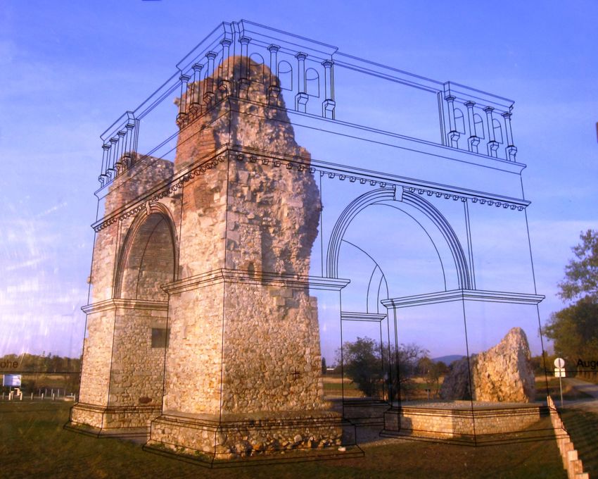
I confirm that this Master’s Thesis in Informatics: Games Engineering is my own work
and I have documented all sources and material used.

Munich, 15.03.2019                              Paul Tolstoi
Acknowledgments

First of all, I want to thank Prof. Gudrun Klinker, Ph.D. for giving me the opportunity
to write my master’s thesis at her chair.
Furthermore, I would like to express my gratitude to my advisor David Plecher for
offering himself as my advisor, for supporting me and all the historic content he
provided.
I appreciate all the participants in the user study for their feedback, support and the
time they gave up for helping me.
From the bottom of my heart, I thank Timo Wagner for reading and annotating this
thesis multiple times.
Abstract

There are many different approaches to use Augmented Reality for historical ap-
plications. However, these are mostly limited to small rooms or objects (museums,
sculptures, etc.). Usually these applications use Augmented Reality to show only
information in form of a text or virtual content. You rarely see e.g. missing parts of
objects especially buildings superimposed onto the real world. This master’s thesis
aims to create a framework for presenting location dependant Augmented Reality
content in outdoor environments. The ultimate goal is to create a generic Augmented
Reality application, that is independent of environmental factors such as different light
or weather conditions, and is not specifically tailored for particular building structures
or traits.

                                           iv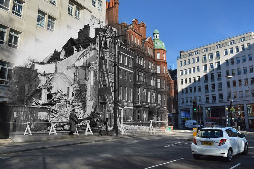
Contents

Acknowledgments                                                                                                      iii

Abstract                                                                                                             iv

Contents                                                                                                              v

1. Introduction                                                                                                       1
   1.1. Motivation . . . . . . . . . . . . . . . . . . . . . . . . . . . . . . . . . . . . . . .                      1
   1.2. Augmented reality . . . . . . . . . . . . . . . . . . . . . . . . . . . . . . . . . .                         1
   1.3. Goal of the thesis . . . . . . . . . . . . . . . . . . . . . . . . . . . . . . . . . . .                      4

2. Related Work                                                                                                       5
   2.1. Historic Methods . . . . . . . . . . . . . . . . . . . . . . . . . .     .   .   .   .   .   .   .   .   .    5
        2.1.1. Heidentor . . . . . . . . . . . . . . . . . . . . . . . . . .     .   .   .   .   .   .   .   .   .    5
        2.1.2. Cities now and then . . . . . . . . . . . . . . . . . . .         .   .   .   .   .   .   .   .   .    5
   2.2. Mobile Augmented Reality . . . . . . . . . . . . . . . . . . . .         .   .   .   .   .   .   .   .   .    6
        2.2.1. IKEA Place . . . . . . . . . . . . . . . . . . . . . . . . .      .   .   .   .   .   .   .   .   .    6
        2.2.2. Cultural Heritage Presentation with Mixed Reality                 .   .   .   .   .   .   .   .   .    7
   2.3. Location-based Applications . . . . . . . . . . . . . . . . . . .        .   .   .   .   .   .   .   .   .    8
        2.3.1. Navigation Systems . . . . . . . . . . . . . . . . . . . .        .   .   .   .   .   .   .   .   .    8
        2.3.2. Geocaching . . . . . . . . . . . . . . . . . . . . . . . . .      .   .   .   .   .   .   .   .   .   10
        2.3.3. Ingress . . . . . . . . . . . . . . . . . . . . . . . . . . . .   .   .   .   .   .   .   .   .   .   10
   2.4. Location-based Augmented Reality Applications . . . . . .                .   .   .   .   .   .   .   .   .   11
        2.4.1. Wikitude World Browser . . . . . . . . . . . . . . . .            .   .   .   .   .   .   .   .   .   11
        2.4.2. City Guide on Mobile Devices . . . . . . . . . . . . .            .   .   .   .   .   .   .   .   .   12
        2.4.3. Pokémon GO . . . . . . . . . . . . . . . . . . . . . . . .        .   .   .   .   .   .   .   .   .   13
        2.4.4. Augmented Reality using Building Facade . . . . .                 .   .   .   .   .   .   .   .   .   14
        2.4.5. Timetraveler: Time of the Berlin Wall in AR . . . . .             .   .   .   .   .   .   .   .   .   14
        2.4.6. MauAR: Experience Berlin Wall in AR . . . . . . . .               .   .   .   .   .   .   .   .   .   15
        2.4.7. HistoricARGuide . . . . . . . . . . . . . . . . . . . . .         .   .   .   .   .   .   .   .   .   16
        2.4.8. Mobile Outdoors AR Cultural Heritage . . . . . . .                .   .   .   .   .   .   .   .   .   16

                                                  v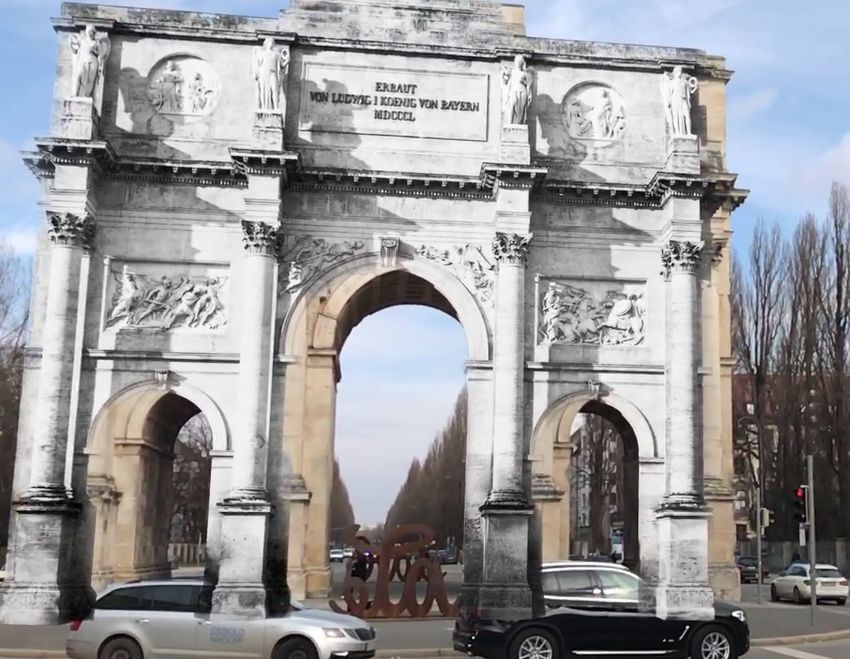
CONTENTS

    2.5. Localization and Camera Pose Estimation Approaches                                         .   .   .   .   .   .   .   .   .   .   .    18
         2.5.1. Localization using Facade Detection . . . . . . .                                   .   .   .   .   .   .   .   .   .   .   .    18
         2.5.2. Robust Model-based Tracking for Outdoor AR .                                        .   .   .   .   .   .   .   .   .   .   .    19
         2.5.3. PoseNet: neural network for pose estimation . .                                     .   .   .   .   .   .   .   .   .   .   .    20
         2.5.4. ColMap: Structure from Motion . . . . . . . . . .                                   .   .   .   .   .   .   .   .   .   .   .    20

3. Implementation                                                                                                                                23
   3.1. General Idea . . . . . . . . . . . . . . . .    .   .   .   .   .   .   .   .   .   .   .   .   .   .   .   .   .   .   .   .   .   .    24
   3.2. Neural Network for Pose Estimation .            .   .   .   .   .   .   .   .   .   .   .   .   .   .   .   .   .   .   .   .   .   .    26
   3.3. Pose Estimation As A Service . . . . .          .   .   .   .   .   .   .   .   .   .   .   .   .   .   .   .   .   .   .   .   .   .    29
   3.4. Mobile Application . . . . . . . . . . . .      .   .   .   .   .   .   .   .   .   .   .   .   .   .   .   .   .   .   .   .   .   .    32

4. Evaluation                                                                                                                                    35
   4.1. Overview . . . . . . . . . . . . . . . . . . . . . . . . . . . . . . . . . . . . . . . .                                                 35
   4.2. Results and User Feedback . . . . . . . . . . . . . . . . . . . . . . . . . . . . .                                                      36
   4.3. Interpretation . . . . . . . . . . . . . . . . . . . . . . . . . . . . . . . . . . . . .                                                 38

5. Future Work                                                                                                                                   39
   5.1. Backend Service . . . . . . . . . . . . . . . . . . . . . . . . . . . . . . . . . . . .                                                  39
   5.2. Mobile Application . . . . . . . . . . . . . . . . . . . . . . . . . . . . . . . . . .                                                   40
   5.3. Content Creation . . . . . . . . . . . . . . . . . . . . . . . . . . . . . . . . . . .                                                   41

6. Conclusion                                                                                                                                    42

Appendices                                                                                                                                        I

A. Tools and Device Specifications                                                                                                               II
   A.1. Device Specifications . . . . . . . . . . . . . . . . . . . . . . . . . . . . . . . . .                                                  II
   A.2. Used Tools and Libraries . . . . . . . . . . . . . . . . . . . . . . . . . . . . . .                                                     II

B. Questionnaire                                                                              IV
   B.1. Pre-Study Questionnaire . . . . . . . . . . . . . . . . . . . . . . . . . . . . . .    V
   B.2. Post-Study Questionnaire . . . . . . . . . . . . . . . . . . . . . . . . . . . . . . VIII

Acronyms                                                                                                                                         X

List of Figures                                                                                                                                  XI

Bibliography                                                                                                                                    XIII

                                                 vi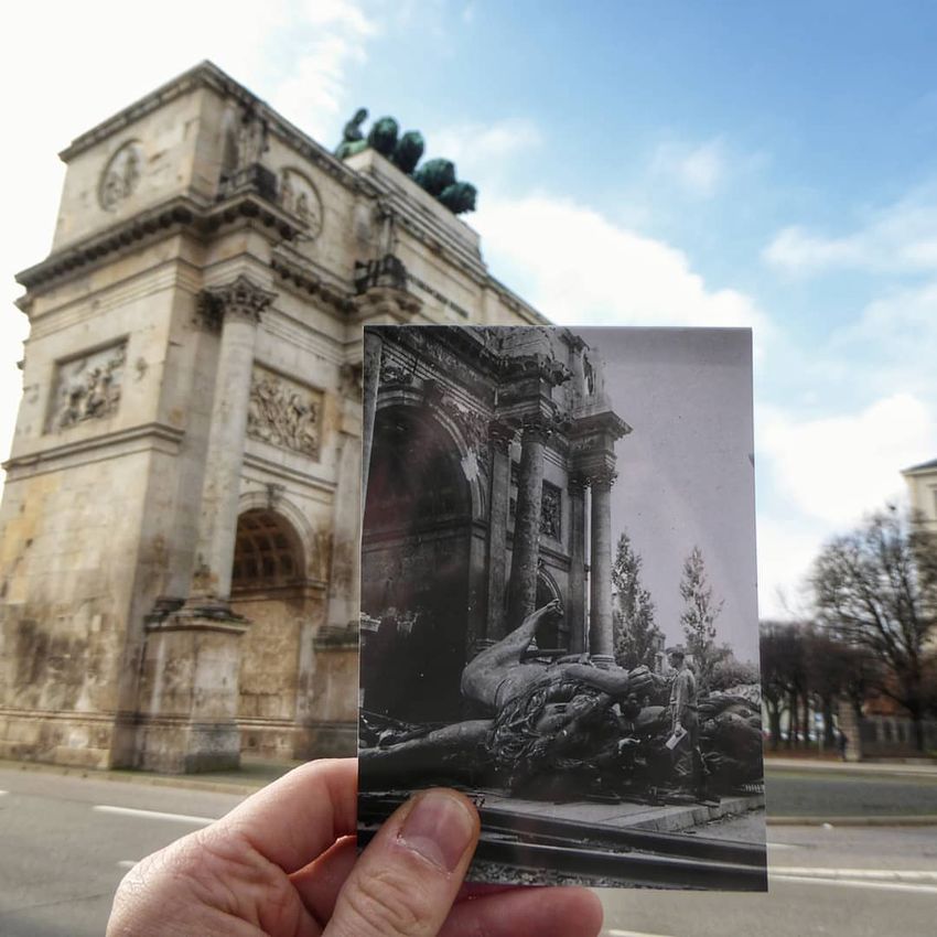
1. Introduction

1.1. Motivation

There are many ways to teach a person about the history of human kind. In school
every student has to learn many historical facts about different events of the past. Most
of the time the only way for the students to acquire the knowledge is to read texts
about what has happened. The text is accompanied with stories of a contemporary
witnesses, sometimes there are some drawings or photos available; and for the most
recent parts of the history there may be even video footage available.
Nevertheless, seeing a historic location with your own eyes might leave a lasting
impression. Almost everyone has done some school trip to a historically relevant
location in their life. More often than not those are some kind of ruins, where students
learn about the past importance of the place and the period of time associated with
it. The knowledge is usually conveyed either by the teacher or a guide; sometimes
there are plaques with some historic photos or sketches. However, right now it is still
not possible to dive into the past and see how the place looked like years or centuries
ago.
Nowadays most EU citizen ([Eur19]) have a smartphone and schools are starting to
have specific classes encouraging students to use a mobile device [Swe10]. So, it is
only obvious to apply modern technologies to teach people historical information.
Displaying virtual content in a historic location could motivate and engage people to
explore and learn more about the days of the past.

1.2. Augmented reality

Augmented Reality (AR) is — as described by Azuma [Azu97] — a technology that
superimposes virtual objects onto the real-world. This technology provides a contrast
to Virtual Reality (VR), since VR does not allow the user to see any real-world con-
tent. He defines that a system should have three specific characteristics to allow AR

                                           1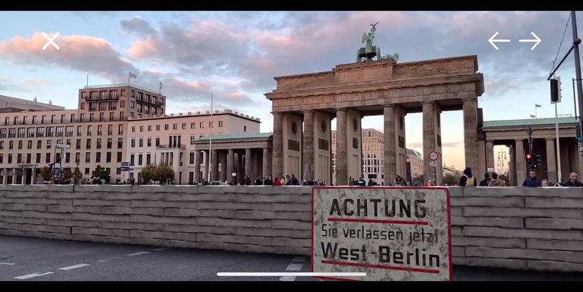
1. Introduction

to be free of specific technologies: Combination of real and virtual, interactivity in
real time, and registration in three dimensions. As counterexample Azuma presents
Computer-generated imagery (CGI), famously known from films, as not being interac-
tive. Overlays, e.g. providing the score during a sports broadcast, are neither interactive
nor "combined with the real-world in 3D" [Azu97]. Since the publication of Azuma’s
survey, the research and especially the industry managed to leap forward and created
better hardware and published many different approaches and frameworks to tackle
the issues presented by AR.
Nowadays most mobile devices like smartphones and tablets contain a built-in camera
and inertial sensors. Additionally, they possess powerful processing units, and thus are
capable of displaying AR content. An AR Software Development Kit (SDK) simplifies
the implementation of AR applications by providing a simple Application Programming
Interface (API) to consume. However, the latest iterations are (at least in some points)
superior to the older ones. As described in my bachelor’s thesis ([Tol14], [TD15]),
tracking of an image target without additional stabilization fails quite easy, if the
camera is moved too fast, the tracked object is obstructed or if the image is too
shiny.

ARCore and ARKit AR SDKs like ARCore ([Goo19a]) and ARKit ([App19a]) are
part of the latest iteration. They provide not only a simple API but more importantly
hardware acceleration. These frameworks are deeply integrated into the operating
system and allow development of mobile applications that are easy on the battery life
while delivering a stable tracking performance.
The main principle behind both SDKs is the same. When an AR-capable application
activates the tracking session, the frameworks begin to track the world around the
device. The content positioned at a certain location inside the provided tracked space
stays at the same location (relative to the real-world), even if the user turns or walks
away. Both frameworks apply visual-inertial odometry for tracking of the environment
([App19b] [Goo19b]). This means they use both the image, provided by the camera, as
well as the inertial sensor data of the device, to ensure a stable tracking even during
periods of fast movement or short time occlusion (e.g. people walking by).
At the time of writing both AR SDKs require different platforms and thus are mutually
exclusive:
   • ARCore requires the devices to run Android 7.0 or later and is only supported by
     some specific smartphones and tablets [Goo19d]. On iOS only the Cloud Anchor
     feature is supported by the ARCore SDK [Goo19e].

                                            2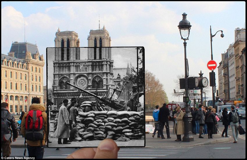
1. Introduction

      • ARKit works only on devices with iOS 11.0 or later and requires an A9 chip or
        better [App19c]. Some features like face tracking only work with specific models
        (e.g. iPhone X/XR). They are, however, not needed for this master’s thesis.
However, there is a way to target both platforms, without developing two different
applications: The Unreal Engine ([Epi19]) as well as the Unity Engine ([Uni18]) provide
official support for both AR SDKs. This allows to develop an AR application once that
works on both iOS and Android devices.

Localization

To deliver location-based information an application must somehow know, where the
user is located. On a smartphone there are different systems available for locating the
device. The availability, precision and battery consumption vary drastically between
different approaches. Systems only suitable for indoor navigation (e.g. Eddystone1
and iBeacon2 ) do not provide a very good precision, but they are therefore very easy
on the battery life. Since this master’s thesis focuses on an outdoor application, these
technologies are not further considered.

Global Positioning System (GPS) GPS is an outdoor location system that is available
to many people. GPS uses "24 satellites, equally spaced in six orbital planes 20,200
kilometers above the Earth, that transmit [...] specially coded carrier signals" [DR01].
After receiving the signals, the device calculates the location with a precision up to 4.9
meters [DE15]. Originally it was developed and used by the US military. However,
since 2000, high precision GPS is available and affordable for civilian use as well. As
of today, almost every smartphone has a built-in GPS receiver and thus can be used
for location-based applications e.g. every iPhone (except the iPhone 1) has a built-in
receiver.
GPS, however, has some limitations:
      1. It consumes a lot of power, e.g. it can reduce battery life down to 7.8 hours in
         contrast to 63 hours when using only GSM [Gao+08].
      2. It can take up to several minutes to get the first location estimation [DR01].
      3. The performance in urban environment is unstable, since it requires direct sight
         of at least four satellites, which cannot be assured due to e.g. interfering buildings.
 1
     https://developers.google.com/beacons/
 2
     https://developer.apple.com/ibeacon/

                                                3
1. Introduction
Additionally, tall buildings reflect the signals and therefore confuse the receiver
[DR01] [DE15].
To reduce the latency that GPS-only localization can cause, there exists an improved
iteration: Assisted GPS. A-GPS downloads the current satellite data using the data
connection of a smartphone reducing the time until the first localization from minutes
to seconds.
1.3. Goal of the thesis
The goal of this thesis is to create a framework that can be used for a range of location-
based AR applications. Such an application should work stable in a large-scale outdoor
environment and be as independent as possible of different environmental factors
like various weather and light conditions. The user should be localized next to a
building or monument, so the app can display AR content next to it, e.g. overlay the
building with photos of how it looked like years ago. The detection and localization
should not require markers, but nevertheless still work correctly with different kind of
buildings, monuments or landmarks. Furthermore, the application should handle the
augmentation well without requiring the objects to have certain traits like a facade, an
arch or depend on availability of a 3D model.
42. Related Work
The goal of this thesis is inspired by preceding research as well as some applications
discussed in this chapter. The idea is to utilize and improve some of them to create a
generic framework.
2.1. Historic Methods
Historically there were some approaches that try to present the past appearance of
buildings and cities to people, without being interactive or requiring the use of modern
technologies (at least for the user).
2.1.1. Heidentor
The Heidentor in Carnuntum near Vienna in Austria is a triumphal arch from the
4th century. It is mostly dilapidated, however it was reconstructed multiple times
throughout the history. The latest restoration was between 1998 and 2001 for which it
was deeply analyzed. Today only small parts of it are standing, as only the western
pillars were restored. On site, there is a glass plate installation (see Figure 2.1) that
shows the outlines of how the original monument probably looked like [Jos02].
2.1.2. Cities now and then
Many photographers and historians often combine photos from different times to show
people how cities around the world looked like years or centuries ago. New York
(see Figure 2.2) underwent many changes, however, it was never destroyed by war.
World War II (WW2) caused devastating destruction of Europe. Between September
1940 and May 1941 Nazi Germany bombed London and different other cities in the
United Kingdom. The photographer Jim Dyson (from Getty Images [Eri16]) created
a couple of images (see Figure 2.3) where he overlays pictures of London nowadays
52. Related Work
Figure 2.1.: The glass plate installation showing the outlines of the former Heidentor in
Carnuntum [Wik16]
with the pictures taken during the time of the bombing. There are similar composed
images from different cities, showing the destruction caused by the war: Nobody
can imagine how it was to see big guns right in front of the Notre-Dame de Paris
(see Figure 2.4). Just like many other cities in Germany, Munich was largely destroyed,
which is nowadays hard to envision (see Figure 2.5).
2.2. Mobile Augmented Reality
Mobile AR applications use the built-in camera and sensors of a smartphone to augment
the real world with virtual objects or information.
2.2.1. IKEA Place
One of the first AR apps created with Apple’s new ARKit is IKEA Place. It was
publicly announced during the Apple Worldwide Developers Conference (WWDC)
in 2017, when ARKit was introduced for the first time [App17]. The app offers the
user to browse through the catalog of IKEA and place life-size furniture in their home
[IKE17]. Additionally, the user can share photos of their virtually furnished home
(see Figure 2.6).
62. Related Work
Figure 2.3.: London, destruction caused by
the Nazi bomb attack; in
Figure 2.2.: Racquet and Tennis Club: left in the background London now
1965, right in 2013 [Zha13] with restored and new build-
ings [Eri16]
2.2.2. Cultural Heritage Presentation with Mixed Reality
This bachelor’s thesis [Kön18] presents an approach, how museums can utilize AR to
provide the visitors additional information on their exhibits. The information might
be as simple as just additional text, but König presents several different kinds of
interactions. One interaction visualizes how a statue most likely looked like in the
past by augmenting its missing parts. The user can either select to display the whole
statue, or to only add some of the missing parts (see Figure 2.7). For this to work,
the application uses a Computer-aided design (CAD) model for tracking. Another
interaction allows the user to dive into a complete small-scale (roughly 17-times smaller
than the original) model of the Parthenon in Athens, Greece (see Figure 2.8) and
examine the inside of the model, since it is not possible to enter and experience the
interior due to its scale. Because there is no CAD model available, König uses Vuforia’s
Object Recognition. The user has to position the smartphone in front of the model
and is then able to see through the building. Yet another way to interact, provided by
the application, is the AR/VR-only presentation of the Acropolis, the hill where the
Parthenon is located. The user can take a look at the ancient site, select buildings to get
textual information and enter a VR mode to experience the actual proportions of the
buildings.
72. Related Work
Figure 2.4.: A gun with a soldier in front
of the Notre-Dame de Paris; in
the background Notre-Dame to-
day [Mic16] Figure 2.5.: The Siegestor in Munich, partly
destructed during WW2; in back-
ground the same monument to-
day [Sch18]
2.3. Location-based Applications
Location-based applications use the physical location of the user to present some
kind of related information. The location of the user provides the context for the
information.
2.3.1. Navigation Systems
Navigation Systems are probably one of the most commonly known location-based
applications. They are available either as standalone devices (portable or built into e.g.
a car) or as an application running on a smartphone. Independently of the device the
common use case is to help the user navigate the best possible route from the user’s
current location to their desired destination. The system guides the user through the
computed route and uses GPS to give helping directions to the driver (e.g. "in 100
meters turn left"), usually with the help of a computer generated voice. In addition,
the interface presents information like estimated arrival time, upcoming traffic jams
or interesting locations nearby, such as a gas station. Usually the device computes
the route in advance, since way-finding on global scale on the fly is slow. Only if the
82. Related Work
Figure 2.6.: Screenshot of IKEA Place: a red armchair is placed virtually in the living room
using ARKit [IKE18]
Figure 2.7.: Crouching Aphrodite aug-
Figure 2.8.: An inside view of the Parthenon
mented with missing
model [Kön18]
parts [Kön18]
current course of the user greatly deviates from the calculated path, the system might
recalculate and suggest a new route. Depending on the device or application the "best
route" is computed with respect to different factors, usually defined by the user. The
user might want to avoid traffic jams, tolls or specific kinds of transportation (e.g. only
use subways) [Nag12].
Possible example applications are Google Maps (see Figure 2.10), available on iOS and
Android, and TomTom, available as a standalone device (see Figure 2.9) or an app for
iOS and Android.
92. Related Work
Figure 2.9.: TomTom standalone navigation Figure 2.10.: Google Maps, a smartphone
app for navigation [Goo19c]
device [Tom19]
2.3.2. Geocaching
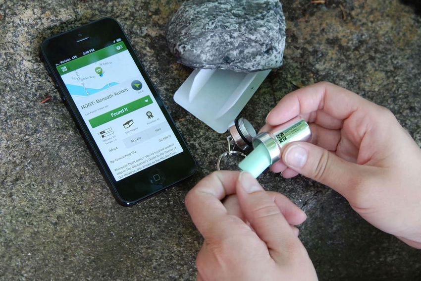
One other location-based application is Geocaching. It is a game-like outdoor activity
where people use a GPS-enabled device to find hidden caches. As described by [OHa08]
a cache is usually "a small waterproof container which can be hidden anywhere in the
world" (see Figure 2.11). The person hiding the cache publishes the GPS coordinates
on a website for other "geocachers" to find. A cache usually contains a "log book" for
the finder to write down when the cache was found. As noted by O’Hara, the main
goal of the activity is not to find the cache. For the geocachers the experience is more
important than the find itself. Additionally, it helps people to motivate themselves to
start walking by sparking the flame of discovery and exploration of new and interesting
places.
2.3.3. Ingress
A location-based game that combines geocaching and Capture the Flag (CTF) into one
single game is Ingress [Dav16]. The game was developed by Niantic and has been
installed more than 10 million times via the Google PlayStore [Nia19a]. The game
screen shows a stylistic map surrounding the player (see Figure 2.12). The player takes
on the role of an agent joining one of the two rebelling factions. The goal of the players
is to capture portals and link them together to create control fields; the bigger the fields
the more score the team gets. A portal in ingress is typically linked to a point of interest
in the real world such as a statue, a monument or another publicly accessible place.
Players have to move in the real world to come close to a portal. Then they can interact
or claim a portal. Players can use a key (obtained from a claimed portal) to link two
102. Related Work
Figure 2.11.: A smartphone showing the location of the cache and person opening the
cache [Geo19]
different portals. The links of portals can never cross already existing links. When
three portals are linked together, they form a control field. The amount of people living
within the control field is counted towards the team score.
2.4. Location-based Augmented Reality Applications
Location-based AR applications combine information based on the location provided
by the device as well as display content in a way that combines the real and virtual
world.
2.4.1. Wikitude World Browser
One of the first AR applications for a mobile consumer device is Wikitude World Browser
[Hau18]. The app was released in 2008. The app allows the user to search for points of
interest and display them using one of three different views: list, map or AR view. The
AR view (see Figure 2.13) shows an overlay representing a point of interest and where
it is relative to the smartphone’s camera. The AR overlay does not provide any 3D
object that combines the virtual and real world, so it is not strictly an AR app as defined
by [Azu97]. In addition, a static overlay displays information about a selected place:
the distance from the user to the location as well as some background information.
Wikitude World Browser lets the user select out of a magnitude of "worlds" — data
112. Related Work
Figure 2.12.: Ingress: Main View of the game showing nearby linked portals [Nia19a]
provider with locations and information, that are either compiled by Wikitude or by
third party sources.
Figure 2.13.: AR view of the Wikitude World Browser [Hau18]
2.4.2. City Guide on Mobile Devices
Cheverst, Davies, Mitchell, et al. present a location-aware city guide for a mobile device
(Fujitsu TeamPad 7600) [Che+00]. This application is designed to support the visitors
in multiple ways (see Figure 2.14). The app provides a feature enabling the user to
122. Related Work
create their own guided tour by selecting multiple attractions from one of the available
categories like "Historic", "Recreational" or "Popular Attractions". When creating a
tour, the guide automatically includes multiple factors like opening hours or when
the location is not crowded. While walking around the city the user can ask the app
about information for the nearby attractions. Additionally, a map provides the user an
overview where they are, and what interesting locations are nearby. Furthermore using
the guide app the user can book accommodation.
Figure 2.14.: GUIDE: A context-aware electronic tourist guide [Che+00]
2.4.3. Pokémon GO
The probably most popular example for a location-based augmented reality application
is the game Pokémon GO. Niantic developed the game and incorporated lessons
learned from their game Ingress. 811 days after launch, the game generated more
than $2 billion revenue ([Pau18]) and has more than 8 million monthly downloads
([Cru18]).
The player becomes a Pokémon trainer and can walk around the world, catch Pokémon,
battle at Gyms or gather items at PokéStops. Gyms and PokéStops are placed at points
of interest in the real world (see Figure 2.15), just like the portals in Ingress. When
walking around the player encounters wild Pokémon which they can catch by throwing
Poké Balls. While catching, the player can use an AR view (see Figure 2.16) to augment
the Pokémon and even take photos and share them.
132. Related Work
Figure 2.15.: Pokémon GO: A stylistic map
view showing nearby Arenas Figure 2.16.: Pokémon GO: AR view
and PokéStops [Nia19b] when catching a virtual
Pokémon [Nia19b]
2.4.4. Augmented Reality using Building Facade
In his master’s thesis [McC13], McClean developed an AR system that uses the planar
facade of buildings for displaying content. To locate the user and display appropriate
content the app tracks the geographic location using GPS and sends it together with
the current image of the camera to the backend service. The backend processes the
image and returns the corresponding content and camera pose. The mobile application
uses the returned data for displaying content (see Figure 2.17).
The processing on the backend happens in multiple steps. First the facade is extracted
using line segmentation, tilt rectification and homography estimation. From the
extracted facade the backend then extracts features and matches them against a database.
Once matched the backend can then retrieve the authored AR content and send it back
to the client.
2.4.5. Timetraveler: Time of the Berlin Wall in AR
Timetraveler is an app developed by Timetraveler Augmented and Metaio for experi-
encing "the history of the Berlin Wall [...] like never before" [Met15]. By using GPS,
the app allows the user to participate in a historical tour and stop by at one of the
eleven major locations. Thanks to optical tracking, at each of the location of historic
142. Related Work
Figure 2.17.: Building Facade augmented with a grid and other content [McC13]
importance Timetraveler can take the user back in time. The user can look at historic
videos (see Figure 2.18) and images and relive the time of the Berlin Wall.
After Apple bought Metaio in 2015 ([Ron15]), the app and the webpage were discontin-
ued.
Figure 2.18.: Demolition of the Church of Reconciliation in Berlin overlaid over the
former location [Met15]
2.4.6. MauAR: Experience Berlin Wall in AR
MauAR [Str18] is an app that was developed by a team of four during the Coding
Da Vinci hackathon in 2017 [Opea]. The idea behind the Coding Da Vinci [Opeb]
hackathon is to bring software developers and cultural institutions together to develop
a prototype during a six-week phase. The prototype should use the data, information
and/or objects provided by an institution in a novel engaging way.
152. Related Work
MauAR uses a combination of ARKit and CoreLocation (framework for obtaining
geographic location and orientation) to show the user where the Berlin Wall stood and
how it looked like. In addition, the app shows visual content such as videos or images
at their historic location. The content was provided by "Stiftung Berliner Mauer".
Figure 2.19.: MauAR: Berlin Wall in front of the Brandenburg Gate [Str18]
2.4.7. HistoricARGuide
In his master’s thesis [Sch16], Schwarzmann uses a markerless approach to augment
historic content on top of buildings. The camera image is processed in multiple steps.
First it is converted to grayscale and normalized using histogram equalization to
make it "illumination invariant". The grayscale image is blurred and edge detection is
applied. Because feature detection would be too expensive to perform on a smartphone,
Schwarzmann uses contour detection since most of the historic buildings have some
sort of arcs, that can be detected and tracked. After detecting and matching the arcs a
corresponding image was overlaid. In addition to an image overlay, the app can display
more information about the building.
Schwarzmann points out in the "Future Work" chapter multiple improvements for the
app. It is only possible to add plain images as an augmentation, neither 3D objects nor
distorted images depending on the user position can be added.
2.4.8. Mobile Outdoors AR Cultural Heritage
Another approach is presented by Panou, Ragia, Dimelli, and Mania. The application
is a "complete mobile tourist guide for cultural heritage sites located in the old town of
162. Related Work
Figure 2.20.: Feldherrnhalle augmented with Figure 2.21.: Siegestor augmented with his-
historic photo [Sch16] toric photo [Sch16]
Chania, Crete, Greece" [Pan+18]. The app has two main modes: map navigation and
camera navigation. The map navigation shows a map of Chania with corresponding
points of interest which the user can select to get more information. The camera view
provides a dot for each point of interest with a small thumbnail (similar to 2.4.1). When
near an AR capable location, the user can use the smartphone to take a look at the
3D model. The user can change between augmenting the whole building or only the
missing parts.
For the AR view the application uses the Mobile AR Framework by HITLabNZ1 as well
as the Wikitude JavaScript API2 .
Figure 2.22.: An Architecture for Mobile Outdoors Augmented Reality for Cultural Her-
itage [Pan+18]
1
https://www.hitlabnz.org/index.php/products/mobile-ar-framework/
2
https://www.wikitude.com/products/wikitude-sdk/
172. Related Work
2.5. Localization and Camera Pose Estimation Approaches
For displaying the AR content correctly, first the devices must be located. There are
many different approaches to do that.
2.5.1. Localization using Facade Detection
There are multiple approaches to utilize facades for localizing the user. The fundamental
assumption for all of them is that the man-made world is to some extend a Manhattan
World ([CY99]). From this assumption follows: each image has some prominent edges
that can be detected, in addition the extension of those usually meet in two or three
specific points (vanishing points).
Chu, Gallagher, and Chen propose a GPS position refinement with additional camera
orientation estimation [CGC14]. For that they use a single photo provided by a camera
and 2D map of the nearby region. The system detects the vertical edges of buildings
and matches them against outlines of nearby buildings on the 2D map.
Figure 2.24.: Estimating Camera Pose
Figure 2.23.: GPS refinement and camera ori-
from a Single Urban Ground-
entation estimation from a sin-
View Omnidirectional Image
gle image and a 2D building
and a 2D Building Outline
outline map [CGC14]
Map [Cha+10]
Cham, Ciptadi, Tan, et al. [Cha+10] propose a similar approach but use instead of a
simple camera photo an omnidirectional image. This approach extracts the vertical
corner edges of buildings as well, additionally it also extracts the normals of the walls.
After the extraction the edges and corresponding walls are grouped, so that they can
182. Related Work
be matched against the 2D map of buildings. From the matches the camera position is
extracted (see Figure 2.24).
Fond, Berger, and Simon do not use a 2D map for the detection and localization of
the camera. Instead Fond, Berger, and Simon propose to use a Convolutional Neural
Network to extract and identify a facade of a building. If the reference database is
extended with geometric information, "a complete 6DOF camera pose can be estimated
for each recognized facade".
Figure 2.25.: Facade Proposals for Urban Augmented Reality: facade detection and virtual
object augmentation on an image from Google StreetView [FBS17]
2.5.2. Robust Model-based Tracking for Outdoor AR
Reitmayr and Drummond present a hybrid approach for tracking and displaying of
AR content in large-scale outdoor environments by incorporating multiple systems
for robustness [RD06]. To guarantee a robust tracking experience the system relies
on an edge-tracker that utilizes a 3D model of the buildings. In contrast to other
approaches, the used 3D model is simple (just simple box-like objects) but it is textured,
which provides better results, even though it has less polygonal details. The "missing"
information is provided by the texture, which additionally allows for automatic filtering
of edges based on the estimated pose of the camera. To minimize the instabilities created
by fast movement, the system incorporates additionally the inertial and magnetometer
sensors. The outdoor environment provides further obstacles such as pedestrians or
cars passing by. To compensate the tracking failures, the approach uses a "point-based
image matching component" to help recover from such failures.
192. Related Work
Figure 2.26.: Model-based estimated pose with overlaid building outline [RD06]
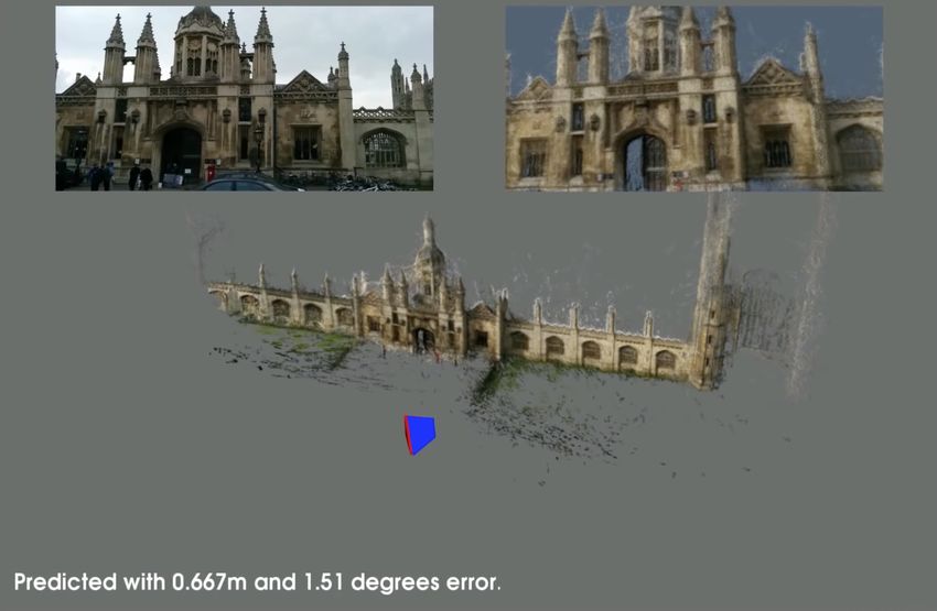
2.5.3. PoseNet: neural network for pose estimation
Kendall, Grimes, and Cipolla from the University of Cambridge use a convolutional
neural network "PoseNet" to generate a "6-DoF pose relative to a scene", using only a
"single 224x224 RGB image" [KGC15]. The base idea is training a neural network that
processes a single image and outputs the pose of the camera. However, to train the
network it is required to first obtain a set of images with the corresponding pose. To
gather this data Kendall, Grimes, and Cipolla propose to first record a number of videos
and then simply extract some frames as images. These images can be fed into a sparse
reconstruction application (such as [SF16]). Finally, the neural network can be trained
with the results of the reconstruction as the ground truth data (namely the position
and rotation associated with each image in the reconstruction). The architecture of the
used neural network is a modified version of the GoogLeNet [Sze+15], a convolutional
network trained to classify an image into one of the 1000 categories. The PoseNet
network is trained using transfer learning, that was "pretrained as a classifier, on
immense image recognition datasets". PoseNet was pretrained with the Places dataset
[Zho+14] that contains different indoor and outdoor scenes with a label. Kendall,
Grimes, and Cipolla state the training takes about an hour on the hardware that they
had available. The results have a median error of "approximately 2m and 3 degrees" for
outdoor environments.
2.5.4. ColMap: Structure from Motion
ColMap is an application by Schönberger and Frahm for an Incremental Structure
from Motion (SfM) pipeline ([SF16]). The application provides additional features e.g.
Multi-View Stereo that are not discussed in this thesis. The result of the Incremental
SfM pipeline is a sparse reconstruction of the scene with corresponding pose of each
202. Related Work
Figure 2.27.: PoseNet: The estimated pose from the input image (top left) predicted with
0.667 m and 1.51 degree error.
Top Right: rendering of the scene from the predicted position [KGC15]
camera. One of the main assumptions of SfM is that the world does not change between
the images. This means that either all the images should be taken at the same time,
or that there must be some compensation for objects that move between the frames
(e.g. a moving car should not influence the pose estimation). Figure 2.28 shows a
reconstruction of the Siegestor in Munich with only 36 images and 4341 points.
The Incremental SfM pipeline consists of two main steps.
Correspondence Search Before the system can begin the reconstruction, some cor-
respondences between the images of the dataset have to be established. To do that,
first ColMap extracts features from each of the images. For the feature detection
and extraction Scale-invariant feature transform (SIFT) is used, since it was imple-
mented working fast on the GPU. After the extraction, ColMap provides multiple
strategies for matching (exhaustive, sequential, VocabTree and other). Underneath
however, it uses a GPU-based SIFT matching. After the matching, each match is verified
212. Related Work
geometrically.
Incremental reconstruction Now that there is some correspondence between images,
the application can begin the reconstruction. After an initial pair is matched, one by
one an image is selected and registered with the reconstruction. The positions of the
points are triangulated and afterwards the poses of all registered images are refined
using Bundle Adjustment. To increase the stability after each Bundle Adjustment the
outliers are filtered out. The reconstruction finishes when all images of the dataset are
either registered or cannot be incorporated.
Figure 2.28.: ColMap [SF16]: Reconstruction of the Siegestor using SfM
223. Implementation
As already stated, the purpose of this master’s thesis is to create a generic framework
for displaying Augmented Reality (AR) content on mobile devices, that is location
specific and works reliably in different lighting and weather conditions. Furthermore,
it should not depend on specific traits of buildings (prominent facade, arcs, etc.) or
require models of the buildings or monuments.
The master’s thesis by Schwarzmann [Sch16] requires that the buildings must have
at least one arc. The arc assumption is in breach of one of the main principles for
this work. Same is true for the works of McClean [McC13], Chu, Gallagher, and
Chen [CGC14] and Fond, Berger, and Simon [FBS17], since they need a facade for the
localization and augmentation. König [Kön18] uses a CAD model for tracking and
augmenting, which is simply not possible to obtain for large-scale outdoor buildings or
monuments. Similarly, the work by Reitmayr and Drummond [RD06] needs a model as
well, however not a detailed but a textured one. The approach by Cham, Ciptadi, Tan,
et al. [Cha+10] depends upon an omnidirectional camera, which is lacking in every
smartphone nowadays.
So, there are multiple problems need that need to be solved:
• Tracking of outdoor scenery proves to be difficult due to varying lighting during
different times of day or weather conditions as well as due to occlusion or
unrelated movement of pedestrians or cars.
• It is not possible to place markers to ease the task of tracking.
• Tracked objects should not require specific traits such as an arc or a facade since
they might not always be present — a statue for example has neither.
• Obtaining or creating a model of buildings or monuments is either time-consum-
ing or simply infeasible.
233. Implementation
Content
As outlined in subsection 2.1.1 and subsection 2.1.2, it would be nice to be able to glance
at history that happened at specific places. Overlaying old photos on top of historically
relevant locations and enriching them with information is the implementational focus
of this master’s thesis.
There are many locations in Munich of historic significance. Many of them date back
to the foundation of the city, others were erected after historically important events.
One of the later is the Siegestor (Triumphal Arch). The construction was initiated in
1840 by the king of Bavaria Ludwig I after the victory over Napoleon and dedicated to
the Bavarian army. During WW2 the monument was partly destroyed and not fully
restored afterwards. Nowadays it serves as a reminder to peace, as the inscription on
the back side says: "Dedicated to victory, destroyed by war, urging peace" (Dem Sieg
geweiht, vom Krieg zerstört, zum Frieden mahnend).
For this master’s thesis I focused on the Siegestor and there are many reasons for that.
Neil MacGregor mentions one of them. As described in his book "Germany - Memories
of a nation": history of Germany is different than the history of other countries [Mac14].
As a lead-in he uses the Siegestor as an example: In contrast to the triumphal arches in
London or Paris, the one in Munich does not only celebrate the victory of a country,
but additionally reminds that dedications to victories can be destroyed by wars. In
conclusion he writes, that this is a good example for the role history plays in Germany,
it shows a past that urges to learn from it. This is the reason why the Siegestor is
such an important monument, which led me to choose the Siegestor as the focus for
this master’s thesis. As an important prominent monument one can easily find many
historic image footages, that can be augmented onto it. Its location is another good
reason, since it stands quite isolated and thus is rarely occluded by pedestrians or
cars. This allows for more uninterrupted testing without disturbing people or the
traffic.
3.1. General Idea
The high-level idea for the use case is quite simple: The user starts the app, points
the tablet or the smartphone at a building or a monument and then takes a look at
some AR content, that is positioned with respect to the object e.g. overlaying an image
showing how the building looked years ago.
The core idea for the implementation is to utilize the stable tracking provided by
243. Implementation
ARKit/ARCore. As outlined in section 1.2 ARCore and ARKit to be able to create a
cross-platform mobile application and use the respective SDK, the easiest way would
be to use either the Unreal or the Unity engine. Due to the bigger market adaptation of
Unity in the mobile sector— 50% of mobile games use Unity as their engine [Uni19] —
and due to preexisting experience with the engine, I selected Unity for the mobile
application.
Independent of the SDK, when the world is being tracked, the application will place
the AR content at the correct position with respect to the real world (e.g. replace the
facade of a building with a historic photo). For that the app must know what content to
show at which "correct position".
What content to show The content to be displayed is location-dependent. A historic
photo of a building, that was standing 5 kilometers away, might not make sense to be
displayed. To determine the correct content the real-world location of the user must be
used. The position estimation can be retrieved using GPS to prune among the different
sites. Depending on the current accuracy of the GPS, it might not be clear, which of the
sites is the nearest one. However, for this master’s thesis, the different sites, that were
tested during implementation, were sufficiently far apart from each other so the content
can be unambiguously selected via GPS localization (Siegestor and Feldherrnhalle).
Furthermore, during the user study only a single site was used, so the users didn’t
have to spend a large amount of time of the study on traveling from one location to a
different one.
Where to show the content After the decision what content to show is made, the
app has to determine where to position the content inside the local AR space that is
provided and tracked by the SDK. The basic idea is to locate the user once, then set an
anchor in the AR space and take advantage of the tracking. To compensate for some
drifting, the application should try to relocate the user from time to time.
For this master’s thesis I tried to utilize two different approaches: First I tried to
integrate the method provided by [KGC15] (see subsection 2.5.3 PoseNet: neural
network for pose estimation). And after the method proved not suitable, I extended the
approach by [SF16] (see subsection 2.5.4 ColMap: Structure from Motion) for usage in
AR.
253. Implementation
3.2. Neural Network for Pose Estimation
As already described in subsection 2.5.3, PoseNet provides a possible solution to the
problem of the estimation of the camera pose inside a certain space. For the evaluation
of the method I used a Keras based implementation of Posenet by Kent Sommer1 . I
chose a Keras implementation, because Apple provides a simple tool2 for conversion
from Keras to CoreML3 , which can be executed directly on an iOS device.
I attempted the training multiple times, since slight changes in lighting and weather
conditions impacted the localization negatively. The images used as the dataset were
extracted from a number of videos of the northern side of the Siegestor, Munich. They
were taken with a smartphone, filming from different angles. The training dataset was
incrementally enlarged:
1. 500 images taken during late afternoon (Figure 3.1 image 1).
2. 206 images taken during midday (Figure 3.1 image 2).
3. 176 images taken during late evening (Figure 3.1 image 3).
4. 367 images taken during night (Figure 3.1 image 4).
5. 149 images taken during rain at midday (Figure 3.1 image 5).
Hence, the final dataset contains a total of 1398 images. I filmed the videos from
different angles, pointing towards the monument (see Figure 3.2). The datasets were
split 80%/20% for training and validation respectively.
After covering almost all weather and lighting conditions, I tried to integrate the
PoseNet results into an AR app. However, during the integration I found out, that the
network produces different pose depending on the zoom of the camera (the dataset
images were taken from videos with a slight zoom for stabilization; the AR view
uses not zoomed camera output). If a camera with a different zoom (e.g. a different
smartphone or tablet) is used the estimation gets really unstable (see Figure 3.3).
At this point I decided to abandon this approach and try a different way to localize the
user.
1
https://github.com/kentsommer/keras-posenet
2
https://developer.apple.com/documentation/coreml/converting_trained_models_to_core_ml/
3
Hardware-accelerated framework for executing neural networks: https://developer.apple.com/machine-
learning/
263. Implementation
Figure 3.1.: Examples for the different parts of the dataset
different images of the Siegestor, Munich; from left to right: late afternoon, midday,
late evening, at night, midday during rain
Figure 3.2.: Location of the dataset overlaid on top of a map (Satellite image taken from Apple
Maps)
Conclusion
The model of PoseNet is about 50 megabyte in size, which should be small enough to
be able to deploy it on a mobile device. During tests using CoreML on an iPhone 7
Plus, the device was able to execute the neural network in less than 1 second. As stated
by Kendall, Grimes, and Cipolla, right now it is not known what the upper limit for
the neural network is (with respect to the maximal "physical area that it can learn to
localize within" [KGC15]). Hence, a single PoseNet model might be able to contain
273. Implementation
10 meters
Figure 3.3.: PoseNet: Predictions are unstable depending on camera zoom
from left to right: original (green), 90% zoom, 80% zoom, 70% zoom, 60% zoom,
50% zoom
grid unit is 10 meters
multiple locations, which should affect the storage and data usage on a mobile device
in a positive way. However, there are a couple of issues with this approach, that led me
to stop pursuing it.
Prone to changing outdoor conditions First and foremost the pose estimation is not
reliable enough for an AR application. It is not camera independent since a simple
change in focal length (zoom) results in a different pose. Furthermore, it is very
susceptible to different lighting conditions such as night vs midday or rainy weather vs
late evening.
Time-consuming preparation Secondly, the preparation steps required before Pose-
Net can be used for estimation are too time-consuming. You have to create multiple
videos (or image sets) during different times of day and during different weather
283. Implementation
conditions. The more images you have, the more time the sparse reconstruction
requires (the feature detection, matching and the reconstruction on my computer
takes about 4 hours for 1398 images). And finally, the training of the neural network
needs additional time (on my computer the training finishes in about 8 hours; see
section A.1).
Outputs a pose for nonsense input Thirdly, the neural network requires some addi-
tional tweaking. PoseNet is trained only on images that have a valid pose and show
a meaningful image (e.g. of the monument or its surroundings). Feeding images of
the Eiffel Tower to a model that was trained on images of the Siegestor, still results in
a pose output, which simply does not make any sense. This can be prevented e.g. by
only executing the neural network after first localizing the user via GPS. An image of
only the sky or the ground near the Siegestor, however, still outputs a pose.
3.3. Pose Estimation As A Service
The main idea behind this approach is to use an SfM application (such as ColMap
[SF16]) for estimation of the camera pose. As described in subsection 2.5.4 ColMap:
Structure from Motion, the application must first detect features, then match them
against other images and finally compute the pose of the images. Since an SfM pipeline
is quite computationally expensive, it makes no sense to run it on a mobile device.
The result would be high battery consumption and it would require too much time
to run. Additionally, parts of the pipeline that are used for stabilization, like Bundle
Adjustment, may take minutes to run, even on a powerful computer. However, if
one strips away those expensive steps, at the cost of stability and precision, it should
be possible to run the application on a powerful computer which offers a remote
service to circumvent the shortcomings of a mobile device. The mobile application
has to only send an image to the backend and use the returned pose within the AR
application.
I decided to extend ColMap with a webservice, since it is open source and supports
GPU acceleration for feature detection and matching.
The webservice combines multiple projects in a single workspace. A workspace assigns
each project a name, a GPS location and a reconstruction. This compound is called site.
A project is provided already by ColMap and contains the images, their features and
properties. The sparse reconstruction consists of image poses, a point cloud and camera
293. Implementation
parameters for each image. The project as well as the reconstruction were provided by
ColMap and did not need any extensions.
Process
For pose estimation the application exposes an HTTP endpoint which expects an image
as the payload as well as either a name or a GPS coordinate (latitude and longitude) as
parameters. The processing happens in multiple steps:
1. Site Finding If a name of a site is passed, the application searches for the site
by name. Otherwise it selects the nearest site to the GPS location passed via the
parameters.
2. Pose Estimation When the application knows which site is the closest, it starts
the pose estimation. Just like during the Incremental SfM (see subsection 2.5.4
ColMap: Structure from Motion), first the backend extracts features from the
image. Afterwards the image is matched "smartly" against the images that were
used for the reconstruction. Finally, the pose is estimated and refined from the
matched images. The refined pose is then sent back.
"Smart" Matching During the startup of the webservice the application creates a
matching queue for each of the sites. First, all the images are sorted by their third most
match. This favors images that have high matches with at least three images. One by
one the images are added to the matching queue. 10% of the images that match with
the just inserted image (sorted by amount of matches) are remembered as neighbor
images and added to a to-be-skipped list. This insertion is applied to all remaining
images in the sorted list and that are not in the to-be-skipped list. In the end all skipped
images are added to the end of the matching queue.
When a new image should be matched, the matching queue is taken as basis. The
images are taken out of the queue, one by one, and matched against the image from the
mobile application. If there are enough matches, all the remembered neighbor images
are prepended to the queue. This ensures that the application favors images that have
many matches. The matching only happens once for each image, and is canceled after a
certain timeout, so the application does not take too long if there are no or not enough
matches.
303. Implementation
Creating a site
An important question is how to create a site. This task has some different constraints
when we use the sparse reconstruction for pose estimation instead of recovering some
geometry. Usually the more images are used the better the reconstruction gets. However,
since the application exploits SfM for pose estimation, having a high number of images
increases the computation time. But, a small amount of images results in worse pose
estimation. So, you need enough images to cover the location/monument from different
perspectives, but not too many since it would simply take too long to match. I found
out that a good balance is to have more images near the object to capture more details,
and only a couple of images from far away (see Figure 2.28). Including images from
different times of day is recommended. Additionally, trying to not include objects
in images, that are not part of the scene (e.g. parking cars or people walking by),
since they might hide parts of the monument. After ColMap completes the sparse
reconstruction it is really important to scale it, so the reconstruction has the same size
as in the real world, otherwise the AR content will be positioned wrongly and appear
somewhere floating around. For easier content creation the reconstruction should be
rotated to match the vertical axis.
Conclusion
Depending on the amount of images and the size of the images, saving a site requires
300-500 megabyte disk space. Since the reconstructions used in this thesis consists
of a small number of images (~100), ColMap’s SfM requires less than 2 hours on my
computer (see section A.1). The time between beginning of the pose estimation and the
incorporation of the pose into the AR application took usually between two and three
seconds.
For the mobile app the main issue is the time between the start of the application and
the first pose estimation. The app must somehow distract the user from the waiting
time, which can vary depending on multiple factors:
Precision As already stated, the pose estimation alone requires a big amount of time.
Successful feature matching increases the precision of the pose, at the cost of computa-
tion time. Additionally, it is not feasible to run Bundle Adjustment for improvement of
the pose estimation, since it would simple take too long to compute.
313. Implementation
Network latency In addition to the computation on the backend, one should not
neglect the network latency. Depending on the bandwidth and latency available during
the upload, round-trip time might increase by a couple of seconds. Depending on
the location and time of day, the mobile data network might operate at (almost) full
capacity, because many people use their mobile devices at the same time, so it may take
longer until the image is sent to the backend.
3.4. Mobile Application
The mobile application is an Unity4 application for mobile devices. It uses AR Founda-
tion5 , a framework that simplifies the usage of ARKit and ARCore within Unity. For
pose estimation the application sends a single frame to the backend while simulta-
neously remembering the pose. When the backend returns the camera rotation and
position, the application instantiates the corresponding Prefab relative to the original
location of the camera. This ensures that the user does not have to hold the camera
perfectly still during the estimation. Right now, the user gets a fake progress bar
(see Figure 3.6) that completes after 5 seconds (usually the estimation is done within
3-4 seconds), which completes fast once the pose estimation is received.
Figure 3.4.: AR view of the destroyed Sieges- Figure 3.5.: AR view of the destroyed Sieges-
tor (Front) tor (Back)
The application provides a "time travel" button allowing users to switch between
different augmentations, e.g. images of the Siegestor before and after the WW2. The
application was tested on multiple devices (see section A.1).
4
https://unity3d.com/
5
https://docs.unity3d.com/Packages/com.unity.xr.arfoundation@1.0/manual/index.html
323. Implementation
Figure 3.6.: Fake Progress Bar distracting the user from the pose estimation
Content Authoring
The AR content is authored within Unity and resides only inside the mobile application.
For the content authoring, I created a helper tool in Unity, that connects to the backend
and pulls the sites that are contained within a workspace. The backend exposes
additionally the point cloud of the reconstruction for each site. The Unity helper
tool shows the point cloud (see Figure 3.7) during the editing of the Prefab, which
contains all the content for a certain site, so the user can position and scale the content
appropriately. When the content author is done with editing the Prefabs, the application
has to be deployed to the mobile device.
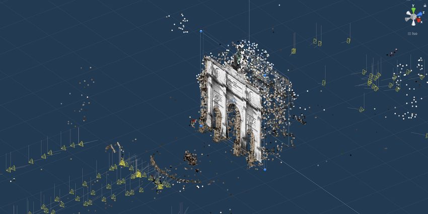
Figure 3.7.: Content Authoring: Point Cloud for better orientation
33You can also read