Development Projects Update - Purpose - Auckland Transport
←
→
Page content transcription
If your browser does not render page correctly, please read the page content below
Agenda Item 9(iv)

Development Projects Update
Purpose
        The purpose of this report is to provide the Board with an update on the significant
        development projects in the region and Auckland Transport‟s role in delivering these. It further
        seeks to inform the Board about the size and likely timing of transport investments that would
        be required within Auckland Transport‟s next Long Term Plan (LTP).

Executive Summary
        There are four significant development projects currently being undertaken by Auckland
        Council and Auckland Transport. These are Flat Bush, the NoRSGA project, New Lynn
        Transport Orientated Development and Long Bay.

        The overall investment required in Auckland Transport‟s 10 year plan amounts to
        approximately $360m, with $280m of that within the first three years. The timing of the
        expenditure is largely driven by the pace of these developments, which largely depends on
        the economy. Auckland Transport therefore has only limited flexibility in managing related
        cash-flows in the LTP in particular as revenues have generally been generated through
        developer contributions (DC).

        The general locations for these are illustrated on Figure 1 below and the current situation is
        summarised in the report that follows.

        Figure 1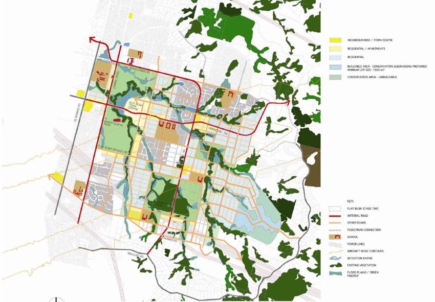
Agenda Item 9(iv)
Project Update – Long Bay
Location
This development is defined in the Long Bay Structure Plan and is generally located west of
the Long Bay Regional Park and north of Glenvar Road. The structure plan area has been
identified as a growth area within the northern boundary of the metropolitan urban limits. A
more detailed map is appended to this report as Figure 2.
Nature of the Development
It is expected that in excess of 2800 lots will be created in the area over the next 10 years.
Todd Property Group (TODD) is the largest landholder in the Long Bay Structure Plan area.
Their development will deliver 2500 residential dwellings and approximately 2.0Ha of
commercial land.
AT Commitment
AT is responsible for the main roads servicing the development area. There are a number of
existing roads to be upgraded and new roads to be constructed and these can be
summarised as follows:
Upgrade of the existing Glenvar Road to meet urban standards
Improvements to the Glenvar Road / East Coast Road Intersection to add either
signals or a roundabout
Improvements to The Glade and Ashley Avenue to accommodate higher traffic flows
Upgrade Okura River Road / Vaughans Road to meet urban standards
Construction of a portion of Glenvar Ridge Road and Beach Road extension to allow
additional access into the structure plan area
Current Issue
The previous North Shore City Council based cost estimates on high level concepts which
have been used to determine the level of DC. Further work undertaken by AT has indicated a
40% increase in the estimated costs for the structure plan roads. This will have an implication
on DC requirements and needs to be worked through with Auckland Council. This work is
now progressing.
Funding and Programme
Funding sources include a mixture of rates, NZTA subsidies and DC. The expectation is that
NZTA subsidy will be based on net amount after deduction of DC and at a rate of 53%. The
total budget identified in the current LTP is $67.5m for the programme. Pending discussions
with AC on DC requirements the intention is to complete the infrastructure within the 10 year
timeframe of this LTP, thereby keeping pace with the rate of development in the structure plan
area. The implication is a budget increase in the LTP to $93m. The current financial forecast
for AT‟s component of the work over the next 3 years is as follows:
2011/2012 - $5.1m;
2012/2013 - $15m; and
2013/2014 - $30m
Agenda Item 9(iv)
Project Update – NorSGA (Stage 1)
Location
NorSGA Stage 1 (Northern Strategic Growth Area) is split into three plan change (PC) areas,
namely:
PC13: also referred to as Hobsonville Point and is located largely on the old
Hobsonville Aerodrome land
PC14: also referred to as the Hobsonville Corridor and is located west of Hobsonville
Point and stretch as far as Marina View Drive. It covers the area of land between
Hobsonville Road and the new motorway extension.
PC15: also referred to as Massey North Town Centre and is located north of the
existing WestGate shopping centre area
A more detailed map is appended to this report as Figure 3.
Nature of the Development
The development is one of Auckland Council‟s “City Transformation” projects aimed at
providing a catalyst for urban intensification. The NorSGA programme has a total area of
1,752 hectares and consists of three stages. Stage 1 covers 435 hectares and is currently
underway. Stage 2 has been developed to concept level and will be incorporated into the
new Spatial Plan. Stage 3 is expected to begin after 2030 and only limited analysis has been
completed on this stage to date.
Stage 1 is subject to the three plan changes mentioned above: Hobsonville Point (Plan
Change 13), Hobsonville Corridor (Plan Change 14), and Massey North Town Centre (Plan
Change 15). The nature of each of these is briefly discussed below:
Hobsonville Point – PC13: 167 hectares of land, the former Hobsonville RNZAF
military airbase, are to be developed. Marine Industry Precinct (MIP) – 20 hectares
set aside to provide a world-class environment for boat building / maintenance and
marine industry businesses. The majority of the land (19 hectares) is owned by the
Auckland Council and the development is being led by Auckland Council Properties
Limited (ACPL). In addition to the MIP there is also an area referred to as „The
Landing‟, which comprise part of the two hectares of harbour front land owned by
HNZC to be developed for boat launching and retrieval activities related to the MIP
and for the provision of a public ferry terminal. The majority of the remainder of the
area is proposed for residential housing, open space, two schools and small areas
of retail and office. The redevelopment is being advanced by Hobsonville Land
Company (HLC), a subsidiary of Housing New Zealand Corporation (HNZC).
Hobsonville Corridor – PC14: 80 hectares of land to be developed. Developments in
this area comprise a village centre (13 hectares) and an employment special area
(67 hectares). Fulton Hogan and Brigham Creek Business Park are the two
landowners that Auckland Council is working alongside to enable this development to
occur.
Massey North Town Centre (MNTC) – PC15: 156 hectares of land to be developed.
The developments comprise a regional centre (100 hectares) for a major mixed-use
town centre larger than Albany and an employment special area (56 hectares). The
key landowners / developers that Auckland Council is contracted to at MNTC are New
Zealand Retail Property Group Limited (NZRPG) and Cannuck Holdings Limited.
NZRPG also owns the adjoining Westgate Shopping Centre and Cannuck (20%
owned by NZRPG) is the major landowner of the MNTC site.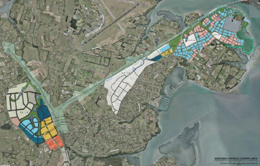
Agenda Item 9(iv)
AT Commitment
AT is responsible for the main roads servicing the development area as well as for a new ferry
terminal. There are a number of existing roads to be upgraded and new infrastructure to be
constructed and these can be summarised as follows:
New Hobsonville Point Ferry Terminal and Bus Interchange;
Improvements to Hobsonville Road to allow for the signalisation of a number of
intersections along this road between marine View Drive and Clark Road;
Replacement of Don Buck roundabout with signalised intersection and improvements
to Hobsonville Road, west of SH16;
Construction of a new arterial road – Northside Drive – between the existing SH16
and Trig Road, including a bridge over the new extension of SH16.
Current Issue
Accessibility to PC 15 is constrained due to limited access options from the State Highway
network. The AT team is working with NZTA to determine appropriate transport solutions that
would improve accessibility to PC15.
Funding and Programme
Funding sources include a mixture of rates and DCs. The Waitakere City Council (WCC)
approved a public amenity and infrastructure investment programme for the three Stage 1
plan changes and provided total funding of $325 million in its 2009 ten year LTCCP. The
budget includes provision of parks, sports fields, roads, community facilities, a new library, a
town square, stormwater ponds, water supply, wastewater infrastructure, land acquisition and
AT‟s share of undergrounding the overhead transmission line at Massey North. AT also needs
to contribute approximately $500,000 towards the design and construction of a 130 bay park
and ride near the ferry terminal. Figures currently available indicate that approximately $19.5
million of this budget has been spent to the end of January 2011; leaving $305.5 million
remaining with $93 million budgeted for the 2010/11 financial year. The current financial
forecast for AT‟s component of the work is as follows (Note that this includes payments to be
made to the developers for infrastructure constructed on behalf of AT under existing private
developer agreements signed by WCC):
2011/2012 - $42m;
2012/2013 - $38m; and
2013/2014 - $22m
Project Update – New Lynn Transport Orientated
Development
Location
This development forms part of PC17 of the old WCC and is generally located within a 1.2km
radius from the New Lynn train station.
Nature of the Development
The New Lynn Urban Plan set a vision to create a sustainable urban place centred around a
world class transit interchange that is capable of attracting and maintaining a population of
20,000 residents and 14,000 workers within the area. Crown Lynn is a precinct within the
New Lynn TOD and is located east of Rankin Ave on the Claypits and Monier site. It is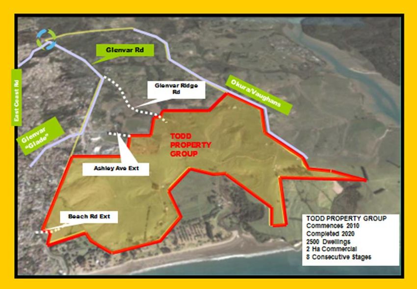
Agenda Item 9(iv)
envisaged as a residential led mixed-use neighbourhood. Existing residential areas will be
augmented by new residential development (approximately 2,500 units, generally to a
minimum three story high) and together this will make the single most important contribution
to achieve the vision target of 20,000 residents living within walking distance of the transit
interchange. Retail, leisure and commercial will all be a feature of ground floors along
continuous frontages to Rankin Ave and the surrounding park.
AT Commitment
WCC committed $144.9m in infrastructure upgrades, to support the investment made by
KiwiRail that enabled the railway line to be lowered into a trench through the town centre. The
WCC investment included upgrades to the train station, bus terminal and adjoining roads.
These works are currently on-going with approximately $46.6m remaining to spend in the
area over the next two financial years. Typical works include the finalisation of Clark Street
extension, McRae Way shared use lane, improvements to Great North Road and further
improvements to the station and bus canopies.
In addition to the $144.9m, a further $19m investment is required to provide roading
infrastructure that will unlock the Crown Lynn area for development. A map of the Crown Lynn
area is appended to this report as Figure 4. The proposed works comprises the design, land
take, demolition of a large building and the construction of three roads: (i) Memorial Drive
Extension; (ii) Hetana Street extension; (iii) Crown Lynn Place.
Funding and Programme
AT has budget to complete the design and land take during 2011/12 financial year with the
construction of the roads programmed for 2012 -2014. The works will be funded through a
combination of DCs and rates. The indicative budgets for completion of the committed works
as well as for the Crown Lynn roads are as follows:
2011/2012 - $32.8m;
2012/2013 - $20.3m; and
2013/2014 - $10.0m
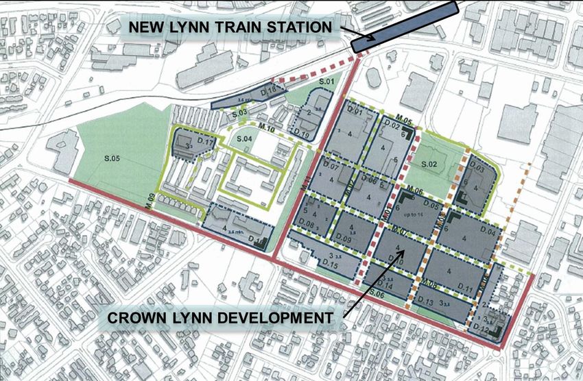
Project Update – Flat Bush
Location
Geographically the Flat Bush Development is located east of East Tamaki and North East of
Manukau Town Centre. The boundaries are approximately, north -Gracechurch Drive, South
and East-Redoubt Road, West Boundary-Chapel Road. (refer to Figure 5)
Nature of the Development
Flat Bush covers 1700 hectares in the south east of Manukau. It will be home to at least
40,000 people by 2020. The development comprises a new 20 hectare town centre that will
be integrated with the 94 hectare Barry Curtis Park. The development will have a wide
diversity of retail, offices, community facilities, five smaller neighbourhood centres, a mixture
of housing densities, seven new state schools, a large community library and an aquatic and
recreation centre in Barry Curtis Park. One of the major features of Flat Bush is Barry Curtis
Park which has been designed to create a regionally significant park.
Town Centre
The planned 20 hectare town centre will include opportunities to live, work and play. The old
Manukau City Council established Tomorrow's Manukau Properties Limited (TMPL) to
implement the town centre and accountability for this has now passed to Auckland Council
Properties Ltd. The vision for the town centre is that it be based around traditional mainstreet
concepts, be compact and pedestrian friendly, have strong ties to the environment and have aAgenda Item 9(iv)
diverse mix of shops, cafes, offices, apartments as well as community and recreation
facilities. Auckland Council Properties Limited has entered into a development agreement with
the TODD group for development of the town centre. Plan Change 20 - Flat Bush, sets out
stage two of plans to develop Flat Bush. It covers 342 hectares of land to the east of the
proposed town centre which the council is proposing to rezone as residential.
AT Commitment
AT is responsible to deliver a Flat Bush Package (approved by NZTA) which includes
upgrades to key arterials, a QTN Route to Manukau, and On-Road and Off-Road Cycling.
Upgrades to roads within the area include improvements to Ormiston Road, Chapel Road,
Flat Bush School Road and Murphy‟s Road.
Funding and Programme
The Flat Bush Road Network Upgrade Package includes a total of $79.6m for arterial road
upgrades and $25.5 for QTN improvements between Flat Bush and Manukau. There is also
additional budget for the development of pathways. The projects are programmed to be
completed over the next 7 years and will be confirmed through Auckland Transport‟s Long
Term Plan process.
Recommendation
That this report be received.
Attachment
Attachment 1 – Figures 2 – 5: Development Project Maps
WRITTEN BY Name: Theunis van Schalkwyk
Title : Project Director:
Corridor Improvements
Name : Rick Walden
Title : Manager Major projects
and PMO
RECOMMENDED by Name : Dr Kevin Doherty
Title : Chief Infrastructure
Officer
APPROVED FOR Name : Dr David Warburton
SUBMISSION by Title : Chief ExecutiveATTACHMENT 1 Figure 2: Long Bay Development
Motorway Extension
                                                                                                         PC13
        (under construction)
                                                            Motorway Extension
                                                            (under construction)

                                                                                                          New Ferry terminal)

                         New Northside Dr

                                                              PC14

                                                                              Upgrade to
           PC15                                                              Hobsonville Rd

                                                                                              AT Road Upgrades
                                            Existing SH16
        Existing Westgate
        Shopping Centre

Figure 3: NoRSGA Development
Figure 4: New Lynn Development
Figure 5: Flat Bush Stage 2
You can also read