Didactic use of GIS and Street View for Tourism Degree students: understanding commercial gentrification in large urban destinations
←
→
Page content transcription
If your browser does not render page correctly, please read the page content below
Investigaciones Geográficas
ISSN: 0213 - 4691. eISSN: 1989 - 9890.                                                                     Interuniversity Institute of Geography
DOI: 10.14198/INGEO2020.MYFM                                                                                                University of Alicante

To cite this article: Martínez-Hernández, C., Yubero, C., Ferreiro-Calzada, E., & Mendoza-de Miguel, S. (2020). Didactic use of GIS and Street
View for Tourism Degree students: understanding commercial gentrification in large urban destinations. Investigaciones Geográficas, in press.
https://doi.org/10.14198/INGEO2020.MYFM

   Didactic use of GIS and Street View for Tourism
     Degree students: understanding commercial
      gentrification in large urban destinations
Uso didáctico de SIG y Street View en el Grado de Turismo: aproximación
        a la gentrificación comercial en grandes destinos urbanos

                                               Carlos Martínez-Hernández1*
                                                     Claudia Yubero2
                                                 Elena Ferreiro-Calzada3
                                                Sofía Mendoza-de Miguel4

Abstract
    Tourism gentrification, as a complex phenomenon in large urban destinations, is an important topic
for future tourism professionals. The aim of this paper is to offer a digital cartography making activity
based on the contemporary dynamics of commercial transformation within tourism gentrification con-
texts in Madrid in order to facilitate its understanding. This innovative teaching activity is in accordance
with the sustainable tourism pedagogy approach and follows an active methodology using three different
GIS applications: Google Street View, ESRI ArcGIS Desktop and ESRI ArcGIS Online Story Maps appli-
cation. A 4-phase methodological design is proposed so that the activity is customizable (1- recognition
of previous ideas), achievable (2- significant streets’ mapping), collaborative (3- collective idea-sharing)
and replicable (4- academic and didactic evaluation). Finally, the results from an initial implementation
are brought to light: i) an initial conceptual lack was found, ii) examples that help to see the proposal
materialized are shown and iii) expected positive consequences according to the scientific literature are
presented. It is concluded that, despite the scarce bibliography, the use of GIS software and Google Street
View in tourism higher education is convenient, not only to facilitate the learning of complex territorial
phenomena but also to learn digital tools highly valued in the professional field.
    Keywords: ArcGIS; ESRI Story Maps; Urban Tourism; Tourism Gentrification; Tourism Didactics;
Higher Education.

Resumen
    La gentrificación turística es un fenómeno complejo, pero su actualidad en grandes destinos ur-
banos lo convierte en un tema importante para los futuros profesionales del turismo. Para facilitar su
comprensión, el objetivo de este artículo es presentar la realización de cartografía digital propia sobre la
transformación comercial que se está produciendo en Madrid en contextos de gentrificación turística. En
sintonía con la pedagogía del turismo sostenible, se presenta esta estrategia didáctica innovadora basada

1 Department of Didactics of Experimental, Social and Mathematic Sciences, Complutense University of Madrid, Spain.
  cmartinezhernandez@ucm.es. * Corresponding author
2 Department of Geography, Complutense University of Madrid, Spain. claudiayubero@ucm.es
3 Department of Geography, Complutense University of Madrid, Spain. eferreir@ucm.es
4 Department of Geography, Complutense University of Madrid, Spain. smendo01@ucm.es

Received: 05/04/2020.                                 Accepted: 07/06/2020.                                       Published in press: 09/11/2020.
                                 This work is published under a license Creative Commons Attribution 4.0 International License.
Martínez-Hernández, C., Yubero, C., Ferreiro-Calzada, E. and Mendoza-de Miguel, S.
en una metodología activa que se sirve de tres aplicaciones del ámbito de los SIG: Street View de Google,
ArcGIS Desktop de ESRI y la herramienta de Story Map de ArcGIS Online. Se propone un diseño metodo-
lógico en 4 fases para que la actividad sea personalizable (1- reconocimiento de ideas previas), realizable
(2- mapeo secuenciado a partir de calles de estudio significativas), colaborativa (3- exposiciones y debate)
y replicable (4- evaluación académica y didáctica). Finalmente, se adelantan los resultados a partir de
una puesta en práctica inicial, entre los cuales destacan: i) una carencia conceptual inicial, ii) ejemplos
que ayudan a ver materializada la propuesta y iii) consecuencias positivas esperadas según la literatura
científica. Se concluye que, a pesar de la escasa bibliografía, el uso de softwares de SIG y el uso de Google
Street View en la formación superior de turismo es conveniente, no solo para facilitar el aprendizaje de
fenómenos territoriales complejos sino también para conocer herramientas digitales muy valoradas en el
ámbito profesional.
Palabras clave: ArcGIS; ESRI Story Maps; Turismo urbano; Gentrificación turística; Didáctica del
turismo; Educación superior.
1. Introduction
Tourism is a modern phenomenon that has important effects on the culture, the environment, and
the economy of societies throughout the World (Santamaria & Filis, 2019). Currently, one of the major
focuses is on the impacts of tourism in urban centers (Novo Malvárez, 2019). Embedded in the broad-
er context of globalization, the process of “touristification” refers to the intensification of tourist use
in urban central spaces (Navarrete Escobedo, 2017). Touristification symptoms are the proliferation of
tourism businesses, such as boutique hotels, but also tourist apartments massively available through
P2P platforms that penetrate the residential districts; the growth of leisure activities, and nightlife in
particular; the disappearance of traditional and local businesses, giving way to large global brands; and
the displacement of the resident population (García-Hernández, De la Calle-Vaquero, & Yubero, 2017).
As growth of urban tourism persists, processes of urban gentrification have been observed. Gentrification
caused by tourism is affecting a growing number of cities around the World, specifically in Europe, and
thus it is a relevant issue in the 21st century (Gravari-Barbas & Guinand, 2017; Calle-Vaquero, 2019).
The transfer from the universities of updated knowledge and critical interpretative frameworks of so-
cial reality is a challenge, and it is an even greater challenge to convey the values of
coexistence, respect,
empathy and sustainability. The activity presented here follows a Sustainable Tourism Pedagogy (STP)
approach which advocates for a sustainable tourism education in continuous co-creation among the
whole society (Jamal, Taillon, & Dredge, 2011; Prebezac, Schott, & Sheldon, 2014). Making the complex
realities of tourism in the city discoverable to future tourism professionals contributes to the reduction
of the existing distance between the knowledge generated in the university and tourism education at all
levels (Belhassen & Caton, 2011).
In this context of pedagogical need —from a theoretical and an ethical point of view— this work
follows research developed previously (Martínez-Hernández & Yubero, 2020). Assuming the didactic
difficulty of the topic, we present an innovative teaching activity with Tourism Degree students. Its main
objective is to facilitate the understanding of contemporary dynamics of commercial transformation in
contexts of tourism gentrification. This activity uses an active methodology following a constructivist
conception of learning (Beltrán, 1993). The development of curricular contents and competences is
sought in its application. The main resource of the activity is the Geographic Information Systems (GIS):
ESRI’s ArcGIS Desktop help us georeference, for a current moment and a past moment, retail businesses
on several streets of the city of Madrid identified thanks to Google Street View. The result is the creation
of a cartographic comparator in ArcGIS Online Story Maps application to explicitly visualize the commer-
cial transformations of each selected street.
Madrid was selected for two reasons. First, it has already been studied as an example of touristifica-
tion and gentrification processes, specifically in a commercial perspective (Sequera & Janoshka, 2015,
2016; Calle-Vaquero, Ferreiro-Calzada, & Mendoza-de Miguel (2018); Crespí & Domínguez, 2016; Bar-
rado-Timón & Hidalgo-Giralt, 2019; Velasco et al., 2019); and second, it is a well-known city for the
target students as they live there or, at least, as they are studying there as explained below. It is widely
accepted that near and well-known spaces help students get a more significant learning in global geo-
graphical phenomena (Benejam, 1992; Pagès, 2009).
2 Investigaciones Geográficas, in press.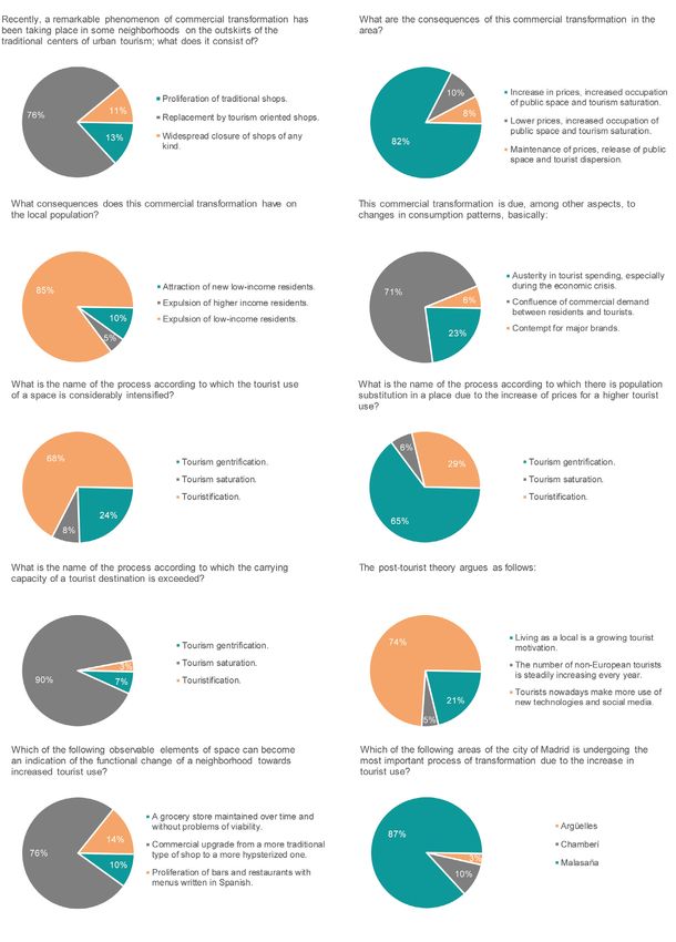
Didactic use of GIS and Street View for Tourism Degree students: understanding commercial gentrification in large urban destinations

    Touristification calls into question the complex, rich, diverse and locally sustainable meanings of
each society. As it is established in the STP (Jamal et al., 2011), only a sustainable urban management
approach based on spatial justice values can bring the coexistence of the different uses in the city. The
current moment is crucial for the awareness of future tourism professionals in the new challenges that
take place in urban spaces and the use of GIS software and familiar data sources such as Google Street
View help apprehend it in an innovative way.
    This study aims at students taking the module “Planning of Tourism Destinations” within the Tour-
ism Degree at the University Complutense of Madrid (UCM). Expected results are anticipated from an
initial implementation in the 2nd semester of the 2019/2020 academic year, which could not be completed
due to the long and strict period of class suspension caused by COVID-19 (UCM, 2020).

1.1. Theoretical framework
1.1.1. Commercial gentrification and Tourism gentrification
     The concept of gentrification designates a process that combines the rehabilitation of urban centers
with population substitution by residents with greater purchasing power causing an increase in the cost
of access to housing and the dismantling of traditional businesses (Clerval, Colomb, & van Crieckingen,
2011). The increasing tourist functionality of urban spaces, also known as “touristification”, is related to
the last modality of gentrification (Aalbers, 2019; Clerval et al., 2011; Cócola-Gant, 2015). The concept
of “tourism gentrification” critically provides new insights into the processes shaping contemporary tour-
ism, contextualizing it in the neoliberal turn of the city’s production (Gravari-Barbas & Guinand, 2017).
     One of the most studied tourism gentrification vectors is the introduction of tourist apartments in
residential areas with the help of P2P platforms such as AirBnB (Wachsmuth & Weiser, 2018; Ioannides,
Röslmaier & van der Zee, 2019). As new urban spaces become accessible and “trendy for tourism”, they
are transformed according to the consumption needs of affluent consumers, whether tourists or residents.
This has been identified as a “commercial update” which, in turn, works to attract more tourists (Fain-
stein & Gladstone, 1999). Stores that supply goods and services of daily necessity are replaced by those
that address “affluent” needs dismantling the traditional businesses and in consequence causing commer-
cial gentrification (Blázquez-Salom Blanco-Romero, Gual-Carbonell & Murray, 2019; Cócola-Gant, 2018;
Gotham, 2005; Romero & Lara, 2015).
     Commercial or retail gentrification refers to the displacement of traditional and local stores and their
substitution by boutiques, trendy cafes and franchises (Hubbard, 2016). Commercial gentrification is
triggered not only directly (by an increase in rents prices) but also indirectly because of forced dispos-
session, produced by the feeling of discomfort in daily life due to the increasing difficulties caused by
the qualitative change of space (Cócola-Gant, 2018). In fact, several authors have studied how the new
cosmopolitan middle class reproduces similar urban environments wherever it goes or settles causing the
change of urban landscapes and the loss of previous urban identity (Zukin, 2010; Maitland, 2010; Hier-
naux & González, 2014; Urry, 1990; Larsen, 2019). These processes have led to new forms of conflict in
the city (Colomb & Novy, 2016).
     For instance, traditional food markets have been adjusted to this upgrading (Gonzalez & Waley,
2013; Crespí & Domínguez, 2016). Extensible to commercial streets, the process of food markets requal-
ification does not try to destroy the commercial functionality but rather to produce new commercial
spaces where “authenticity” is recreated, and shopping is encapsulated as a leisure experience. Commer-
cial gentrification has been observed in many European tourist capitals such as London, Barcelona, Paris
or Madrid (Sequera & Janoshka, 2015; Colomb & Novy, 2016; Gravari-Barbas, 2019; Freytag & Bauder,
2018).
     In order to identify commercial gentrification in Valencia, Romero and Lara (2015) propose a com-
mercial-based mapping where premises are divided into 4 large groups: closed premises (important for
temporal monitoring), traditional commercial premises (i.e. bars, bakeries, furniture shops or hairdress-
ing salons) and gentrifying commercial premises that correspond to a type (decoration, fashion, restora-
tion or culture) and an appellation (vintage, creative spaces, gastro- and eco- or bio-). They set several
indicators to identify gentrifying premises such as: recent opening; type of goods or services sold; nation-
al or foreigner customer orientation of a greater purchasing power; avant-garde, vintage or “authentic”

Investigaciones Geográficas, in press.                                                                                                 3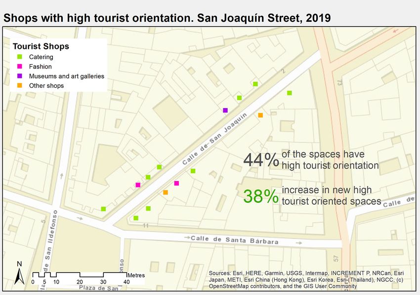
Martínez-Hernández, C., Yubero, C., Ferreiro-Calzada, E. and Mendoza-de Miguel, S.
design that justifies an increase in prices; change in the owner; and use of culture oriented towards elite
consumption (the new premises are cafe-bookstores, shops-galleries, etc.). To this series of indicators,
others can be added such as the opening hours or the languages displayed at the shop windows, as
García-Hernández et al. (2017) apply in the Spanish city of San Sebastián.
Regarding the research methodologies, conventional techniques include census data treatment
(sometimes in GIS), fieldwork, surveys and in-depth interviews. However, with great potential is the
Street View tool embedded in Google Maps which has been considered only recently and exceptionally as
an important data source in tourism research (Ilic, Sawada, & Zarzelli, 2019).
1.1.2. GIS as a didactic resource
Teachers must feel comfortable in the teaching use of Information and Communication Technologies
—ICT— (Amorós Poveda & Díaz Méndez, 2012), as the current educational environment is immersed in
the information society (Hernández Martín and Quintero Gallego, 2009).
The examples of ICT applications in the educational field are huge (Kubricky & Cástkova, 2015).
Specifically, in subjects of a territorial nature, such as tourism, the application of ICT to space is very
common, called Geographic Information Technology —GIT— (Ventura Rodríguez de Castro & Crespo
Castellanos, 2019). One of the GIT tools that has been most developed is the Geographic Information
Systems —GIS—, whose main functions are to capture, analyze, store, edit and represent geo-referenced
data (Korte, 2001).
Being recent GIS use in teaching, it is nonetheless widespread in many countries, more through spe-
cific experiences than as curricular content (Milson, Demirci, & Kerski, 2012). In Japan, for example,
where GIS is common for educational purposes, a lack of teacher training is recognized (Yuda & Itoh,
2006). In the USA, its use is mainly due to local iniciatives (Sinton, 2012). The EU does have a long
tradition of institutional support for educational proposals on GIS, for example with a pioneering 2003
project called “GISAS” (Borghs, M., & Johansson, 2009). There are countries like Germany where some-
thing similar happens; See for example the project “GIS4schools” (Demharter, T., & Michel, 2012). Spain
has received support for the educational use of the GIS through organizations specialized in territorial
sciences such as the National Geographic Institute, a pioneer in presenting digital cartographic resourc-
es through its “Educa IGN” application (Velasco Tirado & Sevilla Sánchez, 2019), as well as powerful
private organizations such as the global cartography company ESRI, through applications such as the
“Atlas Digital Escolar” (Lázaro Torres, Miguel González, & Morales Yago, 2017), but GIS does not have a
curricular presence in the primary and secondary education curricula.
The use of GIS as a teaching resource, through specific software or webGIS, is more frequent in
the teaching of Geography and related disciplines (Jones, Blake, Davies, & Scanlon, 2004; Martínez
Fernández & Delgado Urrecho, 2017), where we can find many experiences at all educational levels, for
instance: Ventura Rodríguez de Castro & Crespo Castellanos (2019), Martínez-Hernández & Martín-
ez-Hernández (2018), Lázaro Torres, Miguel González, & Morales Yago (2017), Buzo Sánchez, Lázaro
Torres & Mínguez García (2016), Ibarra Marinas, Martínez Hernández, Rubio Iborra, Pérez Resina, &
Figueres Cuesta (2015), Martínez Hernández (2014a), Buzo Sánchez (2011), Nieto Masot (2010), Luque
Revuelta (2011), Capel (2010). Other GIS applications have a great potential for education such as Goog-
le Street View. It is a free and fully accessible tool to the public that provides the virtual experience of
walking down the street and provides up to around 10 years of imagery archived that is useful to see the
changes in the urban landscape (Anguelov et al., 2010). However, the educational use of Google Street
View is more recent and less widespread (Carbonell-Carrera & Saorín, 2017).
In the didactics of tourism, the use of GIS is less extended (Stankov, Durdev, Markovic, & Arsenovic,
2012), despite the fact that they are generalized in research (Jovanovic & Njegus, 2008) and the fact that
a good use of the GIS is acknowledged to be a competitive advantage for tourism professionals (Buha-
lis, 1998; Daniele & Mistilis, 1999; Cantoni, Kalbaska, & Inversini, 2010). Some university proposals
for training in GIS and Tourism are those by Guyette (2003) for the USA, Sigala (2012) for Greece and
Stankov, Durdev, Markovic, & Arsenovic (2012) for Serbia. Chiao, Chen, & Huang (2018) do the same
in China also using Street View tools. In the scientific literature, no innovative teaching experiences have
been found specifically about tourism gentrification. There seems to be a significant bibliographic defi-
ciency in this area of tourism
teaching.
4 Investigaciones Geográficas, in press.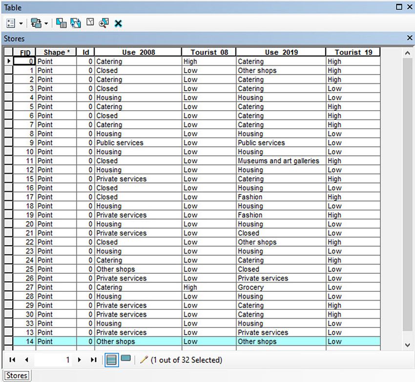
Didactic use of GIS and Street View for Tourism Degree students: understanding commercial gentrification in large urban destinations
For our teaching activity ESRI’s ArcGIS software has been chosen, as it is the most powerful on
the market for digital cartography (Law & Collins, 2018) and for which the university has a corporate
license, the Story Maps tool for its online version and the application Street View from Google, whose
diachronic data availability, free access and widespread use allow students to easily approach commercial
transformation in large urban destinations and to use it as the basis for their cartography. The activity is
designed to be carried out in practical classes, that is of no more than 50 students.
1.2. Curricular framework
Since the incorporation of Spain into the European Higher Education Area, the curricula on tour-
ism have incorporated current multidisciplinary topics and methodologies (Ceballos Hernández, Arias
Martín, Ruiz Jiménez, Sanz Domínguez, & Vázquez Bermúdez, 2010) such as tourism gentrification. One
of the subjects that addresses this topic is “Planning of Tourist Destinations”, taught in the 2nd course
during the 2nd semester in the Tourism Degree of UCM. Covering 6 ECTS, its teaching is assigned to the
Department of Geography (UCM, 2019a).
Our activity aims at covering two of the curricular contents established in the Teaching Record (UCM,
2019b): i) “Problems, agents involved and ways of intervention in urban destinations”, and ii) “Tech-
niques and instruments for the analysis and diagnosis of tourist destinations”. The activity will focus on
gentrification, as one of the main recent problems in urban destinations, using diagnostic techniques,
such as the tourism categorization of commercial shops, the chronological mapping with GIS and Google
Street View, and the collective idea-sharing task. These techniques will help recognize the agents involved
and the means of intervention in the urban destinations affected by this phenomenon.
In accordance with the STP (Jamal et al., 2011) and the pedagogical nature inherent in tourism by
Mair & Sumner (2017), the activity also seeks to develop specific curricular competences of the Tour-
ism Degree: CE5 (“Apply research methodology to solve the empirical problems that arise in the field of
tourism”) and CE18 (“Analyze the impacts generated by tourism and manage the territory in accordance
with the principles of sustainability”).
In sum, considering all these curricular elements (contents and competences) our teaching proposal
is based on the following development of conceptual, procedural and attitudinal contents:
1. Destination Impact Analysis: types of commercial transformation driven by large brands or fran-
chises, new locations, gourmetization, hipsterization, exoticism, opening of bar / restaurants, folk-
lorization, increased nightlife activities, etc.
2. C
onsequences of the commercial transformation: among others, replacement of some businesses
by others, commercial upgrading, closure, price increases, occupation of public space, changes of
use (cinemas and theaters that become stores), expulsion of low-income residents and symbolic
changes in space.
3. C
auses of the commercial transformation: changes in consumption patterns (residents and tour-
ists), business urban planning, globalization.
4. Diagnosis of the changes in space: some peripheral districts become fashionable and touristified.
5. M
ethodology: space indicators such as business’ closure, empty premises, types of products sold,
commercial upgrading, schedules, languages spoken or exposed.
6. D
efinition of the problem in urban tourism destinations: How to distinguish the use made by res-
idents and tourists considering the Post-tourist theory (“leisure residents” vs. “tourists who want
to experience the life of a resident”)? Does tourism gentrification exist? How can it be identified?
To what extent is tourism the cause?
7. Madrid districts as major components of urban tourism destinations, as other global cities.
2. Methodology
Based on the previous theoretical and curricular considerations, we propose a teaching activity se-
quenced in 4 methodological phases (Table 1).
Investigaciones Geográficas, in press. 5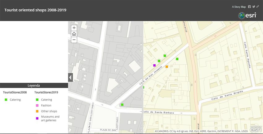
Martínez-Hernández, C., Yubero, C., Ferreiro-Calzada, E. and Mendoza-de Miguel, S.

                                  Table 1. Phases of the didactic sequence for the teaching activity

                                                                Number of
    Phase                          Aim                                                        Tools/Applications
                                                              sessions/hours
         I         Recognition of previous ideas                      1            Google Form
         II        Cartographic digitalization                        3           ArcGIS Desktop and Google Street View
        III        Collective idea-sharing                            1            Story Maps (ArcGIS Online)
        IV         Evaluation                                         1            Google Form
                                                             Own elaboration

2.1. Phase I: previous ideas
    Although the educational curriculum ensures common learning around the topic under study (see
section 1.3), not all students acquire it in the same way, at the same pace or with similar depth (Montero
Segura, 2017). In order to adjust further phases of the teaching sequence with greater rigor and person-
alization (see section 3.2), it is necessary to gather precise information about the previous knowledge
of the students. One way of doing this is through an anonymous questionnaire (Mora & Herrera, 2009),
with questions adjusted to the curricular content to be worked on (Table 2). To standardize the results
of the questionnaire, a list of 3 possible answers is proposed for each question, of which only one is un-
doubtedly correct (Table 2).

                      Table 2. Questionnaire of previous ideas and relation to the curriculum (see section 1.3)

                                                                                                                      Own
                                                                       Answers (the correct one is                development
    Nº                          Question
                                                                             underlined)                          of curricular
                                                                                                                    contents

              Recently, a remarkable phenomenon of              a) Proliferation of traditional shops.
              commercial transformation has been                b)
                                                                   Replacement by tourism oriented
    1         taking place in some neighborhoods on                shops.                                                 1
              the outskirts of the traditional centers of       c)
                                                                   Widespread closure of shops of any
              urban tourism; what does it consist of?              kind.
                                                                a) Increase in prices, increased occupation
                                                                    of public space and tourism saturation.
              What are the consequences of this                 b) Lower prices, increased occupation of
    2                                                                                                                     2
              commercial transformation in the area?                public space and tourism saturation.
                                                                c) Maintenance of prices, release of public
                                                                    space and tourist dispersion.
              What consequences does this commercial            a) Expulsion of low-income residents.
    3         transformation have on the local                  b) Attraction of new low-income residents.                2
              population?                                       c) Expulsion of higher income residents.
                                                                a) Contempt for major brands.
              This commercial transformation is due,            b) Austerity in tourist spending, especially
    4         among other aspects, to changes in                    during the economic crisis.                           3
              consumption patterns, basically:                  c)
                                                                   Confluence of commercial demand
                                                                   between residents and tourists.
              What is the name of the process according         a) Tourism gentrification.
    5         to which the tourist use of a space is            b) Tourism saturation.                                    4
              considerably intensified?                         c) Touristification.
              What is the name of the process according
                                                                a) Tourism gentrification.
              to which there is population substitution
    6                                                           b) Tourism saturation.                                    4
              in a place due to the increase of prices for
                                                                c) Touristification.
              a higher tourist use?

6                                                                                              Investigaciones Geográficas, in press.
Didactic use of GIS and Street View for Tourism Degree students: understanding commercial gentrification in large urban destinations
What is the name of the process according a) Tourism gentrification.
7 to which the carrying capacity of a tourist b) Tourism saturation. 4
destination is exceeded? c) Touristification.
a) The number of non-European tourists
is steadily increasing every year.
b) Tourists nowadays make more use of
8 The post-tourist theory argues as follows: 6
new technologies and social media.
c) Living as a local is a growing tourist
motivation.
a) A grocery store maintained over time
Which of the following observable and without problems of viability.
elements of space can become an b) Commercial upgrade from a more
9 indication of the functional change of a traditional type of shop to a more 5
neighborhood towards increased tourist hipsterized one.
use? c)
Proliferation of bars and restaurants
with menus written in Spanish.
Which of the following areas of the city of
a) Chamberí.
Madrid is undergoing the most important
10 b) Arguelles. 7
process of transformation due to the
c) Malasaña.
increase in tourist use?
Own elaboration
The information on previous ideas acquires great importance under the constructivist paradigm of
learning, according to Piaget, Ausubel, Vygotsky and Bruner, and based on the idea that the knower is
the lead actor of his/her learning based on his/her previous ideas, which he/she modifies and reconducts
in order to shape the new information and thus acquire new knowledge (Guerrero, 2006). With a ques-
tionnaire of previous ideas, not only vital information is obtained to personalize learning, but also each
student is involved in the process. The student is considered as an autonomous, self-regulated being, who
knows his/her own cognitive processes and has the control of learning at hand, becoming eminently ac-
tive (Beltrán, 1993). From this perspective, the act of learning consists of establishing relations between
the already acquired ideas and the new ideas proposed by the teacher. “When the student faces a new
content to learn, he or she does so always armed with a series of concepts, conceptions, representations,
and knowledge acquired in the course of his or her previous experiences” (own translation from Coll,
1990, p. 451).
The timing recommended for this questionnaire is 1 session, spending approximately 3 minutes per
question (1 minute to read and understand the statement, 1 minute to read the answers and 1 minute to
reflect on the correct answer). The rest of the session should be dedicated to explaining to the students
the importance of being aware of their own knowledge starting point when undertaking a participatory
learning process. To guarantee the validity of the answers, it is recommended not to allow access to notes
or similar predefined materials. Besides, in order to ease the collection of information and its evaluative
treatment, it is recommended to virtualize the questionnaire with, for example, Google Form, a free, open
access and easy to use application.
2.2. Phase II: cartographic digitalization
In the session following the previous ideas gathering, the teacher will introduce the concept of
GIS and will present the activity to be carried out, which will need at least 3 sessions. As it is a group
exercise, working groups will be formed (between 3 and 7 members) and each group will be assigned
a study street. It is very important to select adequate study streets, that exemplify very clearly the
topic under study, have public georeferenced data of several years and are assimilable and compara-
ble in terms of workload. Table 3 shows a list of adequate streets in the city of Madrid, whose total
number would cover a class of up to 49 students, a value considered difficult to exceed for a practical
university class.
Investigaciones Geográficas, in press. 7Martínez-Hernández, C., Yubero, C., Ferreiro-Calzada, E. and Mendoza-de Miguel, S.
Table 3. Proposal of streets in Madrid and justification as study cases
Characterization Years with data
Street Location
(own analysis and bibliography) in Street View
Velarde Neighborhoods of the historic center of Madrid, located 2013-2019
on the outskirts of the major tourist attractions (Sol and
San Joaquín Palacio neighborhoods), which have undergone a clear 2008-2019
Malasaña
Santa transformation and touristification accompanied by
gentrification processes. They maintain their residential 2008-2019
Bárbara
function but there is a proliferation of tourist apartments
Regueros and commercial businesses embedded in the “hipster” 2011-2019
culture (Calle-Vaquero, Ferreiro-Calzada, Mendoza-
Hernán Chueca
de Miguel, 2018; Pérez, 2013; Sequera & Janoshka, 2011-2019
Ckortés 2015; Crespí & Domínguez, 2016).
Heart of the urban tourism destination. One of the
Surroundings main tourism attractions. High presence of direct
De la
of Plaza del and indirect tourist activities, all with a long tourist 2012-2019
Victoria
Sol tradition and generally based on the “souvenir” and the
local traditional culture (Crespí & Domínguez, 2016).
A popular residential neighborhood with a traditionally
low-income population (including foreign immigrants),
which is undergoing a clear process of urban
transformation with incipient signs of gentrification.
There is a proliferation of tourist apartments and
Cabestreros Lavapiés 2008-2019
commercial businesses oriented towards “exotic”
culture consumption, which is replacing old traditional
businesses and businesses run by Chinese population
(Sequera & Janoshka, 2015; Crespí & Domínguez,
2016; Barrado-Timón & Hidalgo-Giralt, 2019).
Own elaboration
After logging in with their corporate university account, each group will need to visualize their work
street in ArcGIS Desktop by uploading an OpenStreetMap satellite image. On this image, used as a base
map, they will have to create a new vector layer of points, in order to digitalize the shops and add data
about their typology (Table 4) and tourism orientation (“high” or “low”, depending on the predominant
orientation provided by criteria such as the type of goods or services sold, the opening hours, the lan-
guages of the shop window or the renovation of the front building). To obtain this information, which
is as up-to-date as possible, and to be able to interpret it, they should open Google Maps application in
their Internet browser and use the Street View tool to take a virtual walk along the study street. They will
then need to gather the same information according to the oldest year archived in Street View. The data
obtained are used to create the table of attributes of the digitized layer in ArcGIS. A space of subjectivity
can be expected, as it is usual in social sciences, but all these previous criteria try to both homogenize
the mapping decision task and compensate an out of place external validation. For a learning process, it
seems preferable to draw a trend, instead of specifying indisputable data.
Digital cartography making is a very effective educational and analytical method in territorial studies
of urban transformation as demonstrated by Queiroz Abreu Torres & Antunes Costa (2014) and it is
central to this activity. Students will have to design two maps with the data in the vector layer, one for
the present day and another for the oldest referenced year. The maps will show “high tourism orientation”
shops by typology. In addition, they will have to enrich the maps with descriptive statistical information:
on the percentage of these shops over the total number of shops in the street and, only for the present
day map, also include the growth (positive or negative) of new tourism shops with respect to the oldest
reference year. Finally, both maps must be uploaded to the Story Maps application of ArcGIS Online and
a cartographic comparator must be created, which allows for the controlled overlapping of maps with the
same spatial delimitation.
8 Investigaciones Geográficas, in press.Didactic use of GIS and Street View for Tourism Degree students: understanding commercial gentrification in large urban destinations
Table 4. Typology of shops
Housing
Tourist services
Parking
Tourist accommodation
Grocery
Museums and art galleries
Public services (school, library, etc.)
Catering
Fashion
Souvenirs
Private services (hair salon, bank, dental care clinic, garage, etc.)
Other shops
Closed
Own elaboration
2.3. Phase III: collective idea-sharing.
In the third phase, groups will visually expose their cartographic comparator to all their peers and
explain the data elaborated. The objective is to argue the relationship between the results and the pro-
cesses of commercial transformation in some districts of Madrid. Oral presentations are didactic strate-
gies of proven effectiveness, if they are carried out in a planned and adequate way (Van Ginkel, Gulikers,
Biemans, & Mulder, 2015). In consequence, it is recommended to give them a list of key guiding ques-
tions (Table 5).
Table 5. Guiding questions/considerations for oral presentations
Nº Question/Consideration Motivation
The first step in diagnosing a territorial phenomenon is to locate
Street location with respect to the
the area of study, allowing students to place it in its spatial
1 city’s historic center and the main
context. The possible contexts are an already touristified area or
tourist attractions.
an area becoming touristified.
Evolution of businesses on the ground Shop monitoring allows the students to know the commercial
2
floor, according to their typology. evolution of their study street.
By interpreting whether or not the previously established
Evolution of the tourism orientation
commercial evolution reflects a trend towards touristification,
3 of ground floor business, specifying a
students can deduce whether and to what extent there has been
direct or indirect tourist activity.
a process of touristification.
In conclusion: Is your street occupied
by many predominantly tourism-
4 Next, the diagnosis is explicitly exposed to help them deduce it.
oriented shops? Has it always been
like this?
Finally, they are encouraged to reflect on possible causes
Reflection: Why has this evolution and consequences, to intellectually challenge them to relate
5 occurred? What consequences can it their theoretical knowledge on touristification and tourism
have? gentrification processes, which will later be more explicitly
activated in a large group discussion.
Own elaboration
Investigaciones Geográficas, in press. 9Martínez-Hernández, C., Yubero, C., Ferreiro-Calzada, E. and Mendoza-de Miguel, S.
The estimated time for each group’s presentation is 5 minutes, at an average of 1 minute per guiding
question. Once the groups have presented their cartographic comparators, a large group discussion will
take place on the phenomena of touristification, commercial transformation and tourism gentrification,
in order to explicitly relate this practical exercise to the theoretical contents of the subject. To guide the
debate in an instructive way (De Grez, Valcke, & Roozen, 2009), a list of basic questions has been drawn
up (Table 6), which is recommended to be completed with other personalized questions. New questions
can cover unstable concepts shown in Phase I and during the groups’ presentations. Teachers should
manage the large group discussion in accordance with students’ capacity for response, deduction, induc-
tion and reflection.
Table 6. List of basic guiding questions
Own
development
Nº Question Motivation
of curricular
contents
Each student group has diagnosed a process of commercial
What is the commercial
transformation in their study streets. This question allows
1 transformation derived 1, 3
them to relate it to tourism to understand its typology and
from touristification?
causes.
Not all study streets show the same phase or type of
Has it been found on all
2 touristification. Here the students will be able to explicitly 5
the streets studied?
compare the different types of diagnostics carried out.
Why has it been found By asking them the reasons for these different diagnoses,
3 in some more than in students can better understand the changes in the 3, 4
others? peripheries of the urban tourist areas.
This question initiates the critical thinking of the students,
Is that a good thing or a
4 who will have to reflect on the tourist consequences of 2
bad thing for tourism?
these commercial transformations.
And for the residents? Is Here we extend critical thinking, by posing more variables:
5 there a risk of tourism coexistence of tourism with the residential function, which 2, 6
gentrification? can trigger a conflict of interests.
Does this commercial To complete the critical reflection, we incorporate a
transformation generate mention to sustainability in the use of urban space, so
6 2, 6
a sustainable use of that the students link the phenomenon to the concept of
space? sustainability.
The last phase in the study of this phenomenon is the
What measures can be
consideration of its management to avoid possible
7 established to manage 6
problems, so students are asked to think of corrective
touristification?
measures, based on those studied in theory.
Could you mention some
Finally, students are asked to give examples of the
areas of Madrid where
problems studied that take place in their city, in order to
8 you think a process of 7
consolidate the relationship between the theory and the
tourism gentrification is
cases worked on.
taking place?
Own elaboration
2.4. Phase IV: evaluation
In the current educational panorama, there is no doubt that all teaching activity must end with an
evaluation of its effectiveness (Castillo Arredondo & Cabrerizo Diago, 2010). From an academic point
of view, this evaluation can be done by repeating, also anonymously, the questionnaire of previous ideas,
10 Investigaciones Geográficas, in press.Didactic use of GIS and Street View for Tourism Degree students: understanding commercial gentrification in large urban destinations
understood now as a test of change and/or conceptual consolidation (Martínez Hernández, 2014b), so
that only the improvement of the results would be a positive indicator of learning. However, to complete
the evaluation, a new anonymous questionnaire focused on the didactic effectiveness is proposed (Table
7). The aim is to evaluate to what extent each element of the teaching activity has been adequate, from
the point of view of the knower. To this end, a list of 10 questions has been drawn up with closed answer
according to a Likert scale of values 1 to 5 (lower to higher level of adequacy). An eleventh optional open
answer question has been added to this list as a box for opinions. The results of both questionnaires
should help teachers reflect critically and acknowledge points of improvement (negative results) and
points of consolidation (positive results) for possible future interventions. As Fuentes-Medina & Herrero
Sánchez (1999) state, it is also advisable to share the results in class to facilitate feedback with a construc-
tive approach.
Table 7. Didactic satisfaction questionnaire
Nº Question
1 Have you learned to use a GIS in a basic way?
2 How important do you think learning to use a GIS can be in your training?
3 Have you understood what commercial transformation and tourism gentrification consist of?
4 How interesting do you think this didactic activity is compared to a conventional lecture?
5 How adequate has been the timing established to carry out the activity?
6 To what extent have you found the activity difficult?
7 To what extent has the didactic effectiveness of the exercise been enriched by collective-idea sharing in class?
8 Have the interventions of the teachers been helpful during the activity?
9 How do you value the overall didactic effectiveness of the activity?
10 To what extent have you enjoyed solving the activity?
Make any free comment about this teaching practice (how would you improve it, what didn’t you like, what
11
surprised you, what did you think in general...)
Own elaboration
3. Results
3.1. Previous ideas: initial conceptual lack
A total of 62 students answered the questionnaire of previous ideas. The consistence of this test was
validated by Cronbach’s Alpha, which indicates a moderate, almost good, consistence (0.51). Without
high pretensions of statistical significance and considering that the teaching proposal was not able to con-
tinue, the results allows us to estimate the knowledge starting point of 2nd year Tourism Degree students
about tourism and tourism gentrification. Most students have adequate knowledge of the topic, although
none of the questions was correctly answered by all of them (Figure 1).
Most students identify the topic of study, namely the commercial transformation that is recently tak-
ing place in the peripheral neighborhoods of traditional urban tourism centers, but almost a quarter of
them are confused about what this commercial transformation consists of. This result justifies the need
for an effective learning. This point must aim for 100% right answers after implementing the teaching
activity.
The consequences that commercial transformation has on space are better identified: price increase,
higher occupation of public space and tourism saturation. Even so, 18% of students still confuse some of
these consequences. Something similar happens when they are asked about population: almost 15% do
not identify the expulsion of low-income residents as one of the major consequences. In the implemen-
tation of the activity, explicit mention should be made of each of the consequences so that students can
interpret them significantly.
Investigaciones Geográficas, in press. 11Martínez-Hernández, C., Yubero, C., Ferreiro-Calzada, E. and Mendoza-de Miguel, S.
Figure 1. Results of the questionnaire of previous ideas
Own elaboration
12 Investigaciones Geográficas, in press.Didactic use of GIS and Street View for Tourism Degree students: understanding commercial gentrification in large urban destinations
The causes of commercial transformation are known to a lesser degree. Almost 30% do not recognize
the tendency of commercial demand confluence that has occurred between residents and tourists in large
urban destinations. This would be automatically corrected as soon as students categorize shops since the
products and services that they offer mostly reflect this evidence.
When asked to conceptualize touristification, tourism gentrification and tourist saturation, they only
show a good knowledge of the latter concept, by up to 90% of students. However, between 32 and 35%
do not distinguish the first two concepts. This means that there are students who know how to recognize
tourism gentrification as one of the consequences of commercial transformation (see Figure 2) but they
are not able to conceptualize it. This result is very important when applying the teaching activity because
it warns us not to neglect the more theoretical aspects of the topic, and to ensure that practice and theory
always go hand in hand.
In fact, even if 71% of students recognized the confluence of commercial demand between residents
and tourists, only a mere 21% conceptualizes this trend according to the post-tourist theory in tourism
and cultural studies. Of the entire questionnaire, this is the only question that is mostly answered incor-
rectly, by almost 80% of the students. As we said for the previous concepts, there is no doubt that a teach-
ing effort must be made to avoid a dissociation between contents whose learning is of a more empirical
nature and theory.
To assess the extent to which students understand the meaning of the methodological procedure that
they are going to follow with the digitalization and characterization of shops, they have been asked to
identify visible signs in the space that testify the ongoing process of commercial transformation. The re-
sult is good, as most students can recognize the commercial updating of more traditional shops towards
more “hipsterized” ones as a sign. Even so, almost 25% do not see this indicator, so this will be necessarily
explained further.
Finally, it is relevant to know if the students can localize the phenomenon in their geographical envi-
ronment, since, if this is the case, the significance of the learning is increased. The result is very positive,
since almost 90% recognize the process of commercial transformation in their city, specifically in the
Malasaña neighborhood, where a large part of the streets of study of the proposal are located (see Table 3).
3.2. Mapping and collective idea-sharing management
3.2.1. Theoretical review
Before the digitalization of shops, teachers should spend some initial time reviewing the most im-
portant aspects on the topic, emphasizing the knowledge starting point of students (shown in Phase I).
Some initial knowledge about the phenomenon is required in order to further consolidate it through this
teaching activity.
3.2.2. GIS Presentation
Once the theoretical framework of the topic to be addressed is clear, it is time to explain what GIS
are, since for most students this will be their first digital cartography making activity. Given that the tools
to be used during the activity are few and simple, it is recommended not to make the explanation about
GIS too complex, but to try to give a brief presentation of basic aspects such as georeferencing, digital-
ization, attribute tables and the possibilities of symbols representation. The point here is to give a brief
presentation because specific learning on how to use GIS will be possible when undertaking the activity
with ArcGIS Desktop.
3.2.3. Use of GIS applications
The teachers can then propose the activity and assign each group a study street. The first task for
students is to log in to ArcGIS, load an OpenStreetMap base layer and zoom into their study street. As this
is the first time for most students, it is expected that this task, despite its simplicity, will take up a lot of
time and generate insecurity among students. It would be normal for a whole class session to be taken
up to this point.
Investigaciones Geográficas, in press. 13Martínez-Hernández, C., Yubero, C., Ferreiro-Calzada, E. and Mendoza-de Miguel, S.
In the next session, students should create a new layer of points in order to digitalize the shops on
their study streets. They will be taught how to do this in ArcGIS and will be instructed to use the Google
Maps Street View tool. In Figure 2 an example of the identification of a shop on Google Maps and then
its digitalization in ArcGIS Desktop is shown.
Figure 2. Example of the identification of a shop on San Joaquín Street using Google Street View (left) and its
digitalization in ArcGIS Desktop (right)
Own elaboration
This layer of points will store information on both current and old shop types. Students should learn
how to use the timeline tool of Google Street View. An example is shown in Figure 3. Depending on the
street of study, all kinds of cases may occur such as shops that did not exist before, others that existed
before and are now closed, or simply shops that remain. The trend analyzed by the students of each group
will serve to enrich the subsequent large group discussion, since the selection of streets is based on the
representativity of many different situations. Learning by comparison will then take place.
Figure 3. Example for selecting the 2008 San Joaquín Street display using the Google Street View timeline tool
Own elaboration
14 Investigaciones Geográficas, in press.Didactic use of GIS and Street View for Tourism Degree students: understanding commercial gentrification in large urban destinations
The next task is to fill in the layer’s database, adding new fields to the attribute table on the “typology”
and “tourism orientation” of each record, that is, of each previously digitalized shop (see section 2.2). In
this way, the students will have to apply theoretical content on urban tourism destinations. The teachers
must support this task in order to seek students’ informed decisions and reduce subjectivity as far as
possible. The result will be the creation of a georeferenced database on shops according to their typology
and their higher or lower tourism orientation in each reference year. Figure 4 shows an example of the
process of creating the database.
Figure 4. Example of attribute table for the layer of digitalized shops in San Joaquín street (Use_2008: typology of
the establishment in 2008; Tourist_08: tourism orientation of the establishment in 2008; Use_2019: typology of the
establishment in 2019; Tourist_19: tourism orientation of the establishment in 2019) [See section 2.2. and Table 4]
Own elaboration
In a final session, with this database, students must then create maps for the current and the past
situations showing only the shops with a high tourism orientation and representing them with different
symbols according to their typology. Students should learn how to use the ArcGIS map Layout view. The
basic elements of the cartographic representations should appear on these maps: coordinates, legend,
scale, orientation, title and authorship (Catalá Romero, 2016). Some text boxes must also be included
with descriptive statistical analysis. In the first one, the percentage of shops represented with respect to
the total that had been digitalized must be shown in order to provide information on the spatial density of
tourism-oriented shops in each study street and for both situations. Then, in the second one, information
on the growth of high tourism-oriented shops must be provided in the present situation map, in order to
synthesize the trend of the commercial transformation that they have diagnosed by themselves. Figure 5
shows an example of one of the present situation maps.
The cartographic production ends by loading the two maps into the Story Maps application of ArcGIS
Online, which allows the creation of a cartographic comparator (example in Figure 6). Students can
interactively visualize the evolution of the shops they have digitized, which leads them to actively and
significantly access the dynamics of commercial transformation that they have diagnosed.
Investigaciones Geográficas, in press. 15Martínez-Hernández, C., Yubero, C., Ferreiro-Calzada, E. and Mendoza-de Miguel, S.
Figure 5. Example of a map layout for the 2019 San Joaquín street tourism-oriented shops, distinguishing typologies and
including percentages of their representation over the total number of shops and their growth since 2008.
Own elaboration
Figure 6. Example of a cartographic comparator in ArcGIS Online’s Story Maps, with the map of tourism-oriented shops
on San Joaquin Street in 2008 (gray image) and 2019 (color image). It is interactively available on https://arcg.is/0XqLa5.
Own elaboration
3.2.4. Collective idea-sharing
In order to make students aware of the knowledge generated teachers should ask them for a brief oral
presentation of their cartographic results, of about 5 minutes. In this oral presentation they will have to
make explicit all their learning, channeled through the guiding considerations (see Table 5). Depending
on each study street, each group will show examples, either of touristification initiated decades ago or of
gentrification by recent touristification, alluding to a diversity of concrete cases. Thus, by putting them
16 Investigaciones Geográficas, in press.Didactic use of GIS and Street View for Tourism Degree students: understanding commercial gentrification in large urban destinations
all together, they will have access to all the examples of commercial transformation, in addition to devel-
oping skills in oral presentation, case presentation and critical listening. This information highlights the
diagnosis they have been able to make of the dynamics of commercial transformation and leads them to
ask themselves in what context this happens.
The large group discussion, initiated by the teachers, will redirect the diagnosis of each study street to-
wards the context of the tourism gentrification, making it more comprehensible and committed, through
a series of guiding questions on theoretical, procedural and attitudinal contents (see Table 6). In our
case, assuming the results of the questionnaire of previous ideas, we would have to insist on the concep-
tualization of the processes that the students have diagnosed. Having created themselves some maps of
commercial transformation dynamics, it will be much easier for them to associate theoretical concepts
related to the subject, due to the achievement of a significant learning (Coll, 1988). Likewise, with their
participation in the collective idea-sharing task, students will develop communication skills based on
argumentation and respect for other interventions.
4. Discussion
The didactic effectiveness of this exercise is based, on the one hand, on the coverage of a series of cur-
ricular elements (see section 1.3) and, on the other hand, on the use of GIS as a didactic resource, which
in the professional domain can be very useful (see section 1.2.2). In the questionnaires that would have
to be passed at the end of the whole activity (validation of previous ideas and didactic satisfaction) we
expect positive results, given these considerations on didactic effectiveness.
The use of GIS can be evaluated from a double perspective: firstly, as a didactic tool to achieve learn-
ing on a territorial subject; secondly, as a learning object in itself. This teaching practice aims to cover
both perspectives. The didactic effectiveness of GIS has already been tested in other works, which co-
incide in highlighting its importance in increasing motivation (Alcántara Manzanares, Rubio García, &
Mora Márquez, 2014), facilitating collaborative and cooperative learning (Vega, 2012) and improving
curricular learning (Lázaro Torres, Miguel González, & Morales Yago, 2017), as long as there is hardly no
important limitations in its use (Jianya, Yue, Tsehaie, Fuan, & Anjana, 2017), as is the case here. Martín-
ez Hernández, Ibarra Marinas, Pérez Resina, & Figueres Cuesta (2016) found that the use of GIS in the
classroom had increased students’ interest in the topic. Students appreciated the learning acquired and
recognized a more enjoyable and motivating teaching process. Muñiz Solari, Demirci, & Van der Schee
(2015) recognize the great usefulness of geoinformation tools in teaching practices. In fact, Arranz López
et al. (2013, p. 192) state that “the attraction for virtual tools that are usually used outside the academic
environment should not be underestimated”. This idea is shared by Carbonell-Carrera & Saorín (2017),
who verify an increase in student motivation through Street View tools. Moreno Vera (2016) highlights
the high value of success in class exercises using web-mapping, which he estimates at 93%. Here we can
expect similar results, both qualitatively and quantitatively.
Despite the scarce literature, the didactic effectiveness of GIS in tourism teaching has already been
highlighted (see section 1.2.2). Sigala (2012) recognises that the inclusion of GIS in tourism higher ed-
ucation allows students develop two main spatial competences: the use of maps to explore and present
information and the creation of their own maps to encourage communication and collaboration. With
our teaching design we hope to facilitate both, since students must create and interpret their own maps.
Davies (1998) concretizes the didactic value of GIS in the possibility of interacting with different layers
of information to make the relationship between spatial variables clearer. Our students will take this pos-
sibility with the creation of the cartographic comparator. Chiao, Chen, & Huang (2018) also highlight
the importance of the interaction allowed by the Street View tools to improve tourism learning. Molina
Torres (2017) adds a consideration concerning specifically heritage: GIS for teaching purposes activates
the awareness of conservation. Heritage is certainly involved when studying historic city centers. It is also
important to highlight the attitudinal learning that GIS allows in line with STP (Jamal et al., 2011): it fa-
cilitates the understanding of unsustainable territorial realities. Stankov, Durdev, Markovic, & Arsenovic
(2012) show that tourism students who have used GIS at the university pass their grade with an average
value of 4 out of 5. Guyette (2003) stresses that with the use of GIS, tourism students increase their un-
derstanding of database management and analysis, as would likely be the case in our teaching proposal
when creating and managing the attribute tables of the layers created by the students.
Investigaciones Geográficas, in press. 17You can also read