Dolomite Point: the development of a limestone landscape - Neil Silverwood March 2019 - Wilderlife
←
→
Page content transcription
If your browser does not render page correctly, please read the page content below
Dolomite Point: the
development of a limestone
       landscape

       Neil Silverwood
        March 2019

                             1
Table of Contents
Purpose ............................................................................................................................. 3
Author ............................................................................................................................... 3
Introduction ...................................................................................................................... 3
Relevant legislation ........................................................................................................... 3
Land status and site map ................................................................................................... 3
Stakeholders...................................................................................................................... 4
Dolomite Point as a karst feature ...................................................................................... 4
Underpass ......................................................................................................................... 7
Razorback Point Carpark ................................................................................................... 8
Relationship with Williams Hotels ..................................................................................... 9
DOC as a developer ........................................................................................................... 9
Development ‘creep’........................................................................................................ 10
Visitor center ................................................................................................................... 13
Lighting at the Pancake Rocks ......................................................................................... 15
Process, relevance and timing of the Assessment of Environmental Effects (AEE) ............. 15
Recommendations ........................................................................................................... 16
Conclusion ....................................................................................................................... 17

                                                                                                                                      2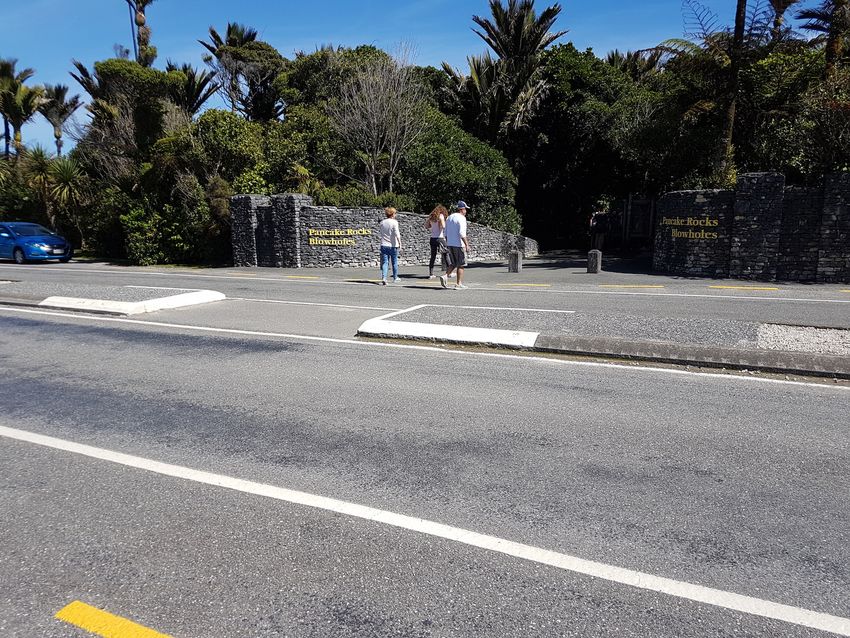
Purpose
This document aims to provide an in-depth view of the proposed redevelopment of
Dolomite Point and the surrounding area which has been supported by the Provincial
Growth Fund (PGF). The advice contained within is independent, if it contains a bias, it is
one toward preserving public conservation land and karst and caves. A great deal of time
has been invested in researching the proposed changes, communicating with stakeholders
and undertaking site visits to areas affected. I hope that this document will be given due
consideration and used to help reshape the development in a more sustainable manner.

Author
Neil Silverwood is a cave and karst specialist and is the lead author on the Department of
Conservation’s Western South Island Region Cave and Karst Operational Plan 2018, co-
author of Caves: Exploring New Zealand’s Subterranean Wilderness, lead contractor for the
Department of Conservation’s West Coast cave management programme, has held the
position of Conservation Officer for the New Zealand Speleological Society, and has been
extensively involved in the exploration of New Zealand’s longest and deepest cave systems.

Introduction
Since 2007, the Department of Conservation (DOC) and other interested parties have been
in the process of considering upgrading the visitor facilities at Punakaiki. A number of plans
have been created but have failed to gain funding. In early 2018, the government provided
$100,000 to create a Punakaiki Master Plan. Boffa Miskell, a company specialising in
landscape architecture, were commissioned to design a concept plan which was used to
shape the recent PGF application. The Dolomite Point Redevelopment Project (DPRP) was
awarded $26.5 million in late 2018.

Relevant legislation
The Conservation Act 1987
The National Parks Act 1980
West Coast Tai Poutini CMS 2010-2020
Paparoa National Park Management Plan 2017
Western South Island Region Cave and Karst Operational Plan 2018

Land status and site map
The status of the land at Punakaiki is complex and includes public conservation land made
up of national park, stewardship land and reserve as well as small privately-owned parcels.
The majority is public conservation land (PCL).

                                                                                                 3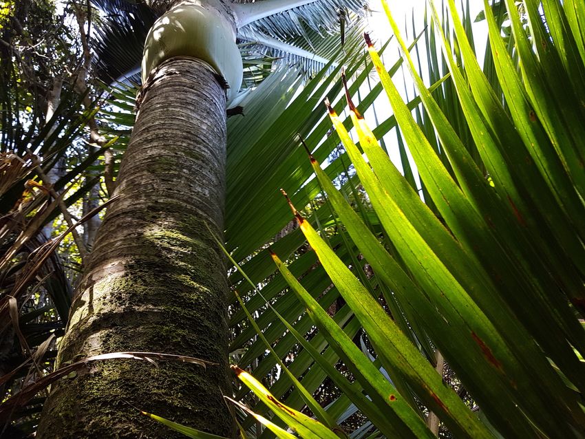
Stakeholders
Key stakeholders in the project are Ngati Waewae, Development West Coast, Buller District
Council, DOC and the Williams Hotel Group. The PFG application for redevelopment listed
the project interest as economic rather than conservation-based.

Dolomite Point and the area surrounding the visitor center is karst, a unique landform
marked by caves, sinking streams, limestone cliffs and blow holes. While DOC is to be
commended for working with a wide range of stakeholders and undertaking some public
consultation in local communities, it is puzzling why key organisations with specialist skills in
karst management such as the New Zealand Speleological Society (NZSS) and Australasian
Cave and Karst Management Association (ACKMA) have not been engaged. Furthermore,
there is no representation from any environmental organisations to provide a more
balanced view. For example, with the Oparara Development – in an equally important area
of karst and fragile ecosystem – the NZSS, FMC and F&B are listed as key stakeholders. The
West Coast branch of F&B and the NZSS at minimum should be key stakeholders at
Punakaiki as well. I also argue that due to the impact of the development, full public
consultation should be undertaken before work on the project begins. Prior to the
application process no independent review was undertaken nor has any form of
environmental assessment been undertaken to date.

Dolomite Point as a karst feature
New Zealand’s land area is 268,000km2 but only 3% is karst. The average karst land coverage
around the world is 14%. Of the karst we have in NZ, 60-70% has been heavily modified
through agriculture, logging, quarrying and tourism developments. Unmodified karst is a

                                                                                                4
rare commodity. Dolomite Point is a partially modified area of karst – its current, most-
significant threat is tourism development.

Dolomite Point karst stretches from the blowholes to the hill directly behind the visitor centre.

Dolomite Point is the area of karst that stretches from the coast at the tip of the Pancake
Rocks peninsula inland to the base of the hill behind the visitor centre, approximately 500m
inland. The northern natural boundary is marked by the sea cliffs and Punakaki Cavern. To
the south, the boundary is where the beach meets the Pancake Rocks cliffs.

Dolomite Point is made up of exposed karst and paleokarst (karst buried by sediment).
The karst on the western/ocean side is heavily weathered and is a fragment of a much
larger area that has been eroded away. The breakdown of the current feature is a mixture
of solution from C02-rich water penetrating the karst surface and abrasion from wave
action.

Due to difficulty of access, potential caves at Dolomite Point have not been fully explored
and are little understood. However, there may be cave development throughout the area.
The caves are likely formed in the coastal mixing zone between fresh and salt water. The
karst and caves are strongly joint-controlled with joints running along an east-west axis.
Water submerging in dolines (karst depressions) and dry valleys around the visitor centre,
for example, probably travels along these joints and resurge in sea caves under the Pancake
Rocks.

                                                                                                    5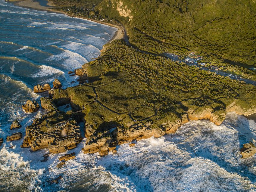
The relationship between the karst surrounding the visitor centre and on the land to the
east is little understood and further work is needed.

Dolomite Point caves and the speleogenesis and hydrology of the area are little understood. Image taken
March 2019.

The only known significant cave in the area is Cassies Cave which is located inland from the
visitor centre. It has only been partially explored and is so far 1,280m long. It is well-
decorated (contains formations such as stalactites), contains subfossil deposits and is
accessed by walking up behind the visitor centre. The cave contains a low-energy
streamway which submerges at the end of the known system. The stream’s subterranean
path from that point is unknown. It may travel underground to emerge under the Pancake
Rocks.

Before any work that could affect Punakaiki’s karst is undertaken, the area’s complex
hydrology should be studied. Care also needs to be taken to avoid disturbance of karst
features. For example, there are small dry valleys where the northern carpark extension is
planned. The proposed carpark would modify these valleys irreparably. It would be more
desirable to keep the carparks within their current footprints than to lose karst features.
Deforestation and pavement would also have a negative effect on the caves below these
areas as the hydrology would change and runoff from the parking lot could enter the
underground system.

                                                                                                          6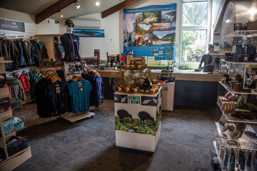
The Western South Island Region Cave and Karst Operational Plan 2018 states,
“Karst also involves the complex interaction of many processes, ranging from geology
to climate, from ecology to hydrology. In managing karst, it is essential to view it
holistically; to understand that all the features and processes of karst interact as
an open, dynamic and integrated system. The underground parts of the system are
not independent of the surface. The way karst surfaces are managed can have
significant consequences for the subterranean environment. Human impacts on
karst may be far-reaching but they are often invisible to most people. In addition,
management methods which may be suitable in other environments may be
unsuitable for karst.” [emphasis added in bold]
For example, before considering increasing the footprint of the current visitor centre and
carparks, research should be done as to the potential effects on the karst and caves below
the proposed development site. Furthermore, this should put the current proposal in a
wider context by considering the scarcity of karst as a resource.
Underpass
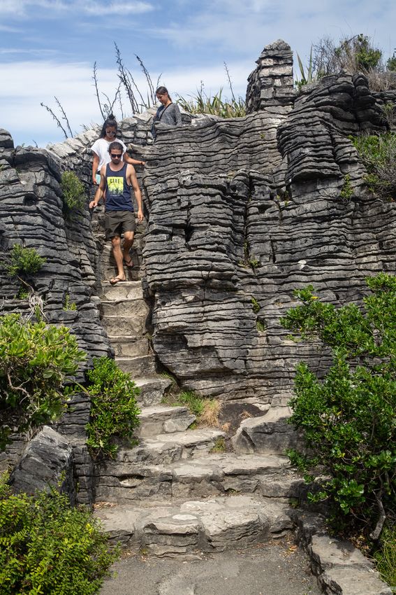
Boffa Miskell’s concept master plan shows an underpass with four entrances. The proposed
underpass can be accessed via a lift and stairs thus removing the need for visitors to cross
the road.
A simple pedestrian zebra crossing with a safety barrier would provide a safe crossing and remove the need for
a lift/stair-accessed underpass. The speed limit could also be reduced. Image March 2019.
7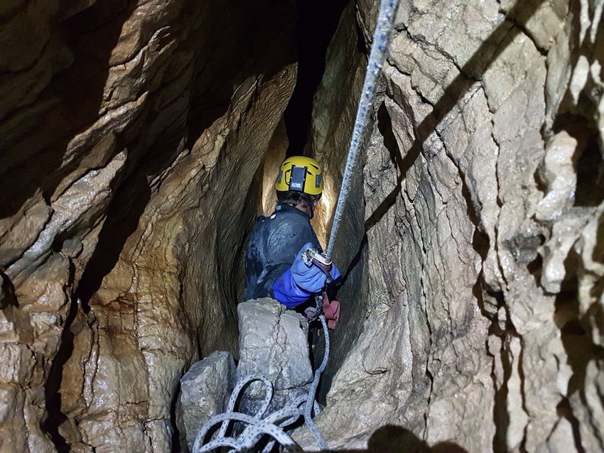
The underpass proposal means tunneling through an area of karst. The blasting required
could have detrimental effects to any caves nearby, could result in nearby cave collapse and
may influence the areas hydrology. In my opinion, an underpass is not appropriate in a karst
landscape.

Punakaiki gets 500,000 visitors annually. That’s an average of 1,388 people per day
although there are more in the summer season than winter. However, this aspect of the
development still seems extravagant and unnecessary.

A more moderate plan would be to simply install a pedestrian zebra crossing with safety
barrier and lower the speed limit through the tourist crossing area from 60km/hr to
30km/hr. This could be completed at a fraction of the cost, would allow for both pedestrians
and wheelchair access and would not cause unnecessary damage to the karst.

If a pedestrian crossing is not deemed suitable, the next best solution in a karst landscape
would be an over-bridge. This structure would be semi-permanent, cause no long-term
damage, be significantly less expensive and have little to no effect on the hydrology of the
karst.

Any permanent changes to the karst, especially where the hydrology is affected, are
inappropriate. Additionally, the western end of the underpass would fall within Paparoa
National Park. I believe a national park is an inappropriate place to build an unnatural and
intrusive structure.

From the West Coast Tai Poutini CMS 2010-2020,

        “Paparoa National Park stands as a premier example of natural new Zealand. it is
       one of the few national parks where natural quiet predominates and is a sanctuary
       for a diversity of nationally and internationally important geological features and
       indigenous plants and animals. the Park is uncluttered by intrusive structures.”
       [emphasis added in bold]

While on their own each aspect of the proposed redevelopment represents a small change,
as a whole they add up to larger effects to the hydrology and intactness of a unique karst
landscape.

Razorback Point Carpark
The concept of a carpark on the true left of the Punakaiki River has some merit. This would
at peak times decrease the pressure on the visitor centre parking area and remove the need
to extend the car parks at Dolomite Point. However, the vague map provided shows the
carpark very close to, or even directly below the Weka Wall climbing crag – an important
recreational site for the local climbing community and visiting climbers. This crag contains a
number of accessible sport climbing routes and is the most popular rock-climbing crag in the
Punakaiki/Bullock Creek area. Consideration should be given to the effects of a carpark on
recreation at the Razorback Point site. There is also a significant artesian spring here which
was once the source of the river mouth township’s water supply. Consideration should be

                                                                                               8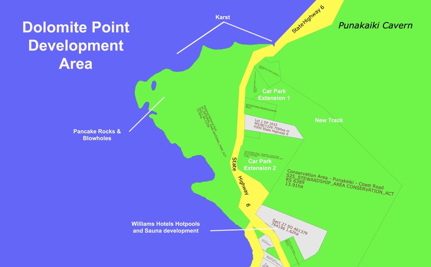
given to the effect of this carpark on the spring. The area should be considered, in part at
least, as karst and managed accordingly.

Relationship with Williams Hotels
Williams Hotels (Williams) are a large South Island-based hotel chain listed as a stakeholder
in the PGF application. The hotelier has a vested interest in the proposed redevelopment as
they plan to build hot pool and sauna facilities at the southern end of Dolomite Point on a
freehold section surrounded on three sides by public conservation land. They have
provisionally agreed to share water and waste water services with DOC. The private land
recently purchased by Williams is forested. This development will degrade the area by
removing pristine vegetation in the paleokarst band on the east side of the road. This area
of bush is the mixing zone between windsheared coastal scrub, flax and lowland forest.
Because much of the existing Punakaiki development has taken place in this zone, the area
where the hot pool facility is proposed represents the most intact section of the mixing zone
flora left and would be a considerable loss.

The development requires resource consent and DOC are an affected party due to the fact
they manage the land on three sides of the proposed Williams development. Access to the
site is also planned via DOC-managed land. Developing a road and tracks would involve
more deforestation of an ever-decreasing resource.

DOC have formed a close working relationship with Williams and are unlikely to have much
appetite for opposing the development. This highlights the risk of DOC becoming
development-focused and placing the needs of tourism and business over those of
biodiversity and landscape conservation.

A hotel chain is a poor bedfellow for a conservation organisation and DOC as an affected
party should distance themselves from the proposed developments. The Williams hot pool
plan threatens to degrade the natural environment and is an inappropriate commercial
venture in the sensitive Dolomite Point environment.

DOC as a developer
A recent trend in the Western South Island Region is DOC have begun to take a stronger role
in driving the development of public conservation land for tourism. Other examples include
the Oparara Basin and Hokitika Gorge developments.

The Conservation Act 1987 provides a hierarchy to guide DOC in land management.

“6 Functions of Department
       The functions of the Department are to administer this Act…

               …(e) to the extent that the use of any natural or historic resource for
               recreation or tourism is not inconsistent with its conservation, to foster the
               use of natural and historic resources for recreation, and to allow their use for
               tourism…”

                                                                                               9
DOC’s new role as a developer shifts the Department away from its legislated purpose to
one where it actively fosters tourism and at times places tourism above conservation.
I note that in the Western South Island Region there are currently three large projects on
public conservation land – the proposed Oparara Development, the proposed Dolomite
Point Redevelopment and the new Hokitika Gorge track extension (ongoing) and car park
extension (complete). The first two of these are multi-million-dollar projects and though the
main funding comes from the PGF, these projects require investment from DOC in terms of
time, resources and future maintenance.
Traditional recreational infrastructure, however, is becoming increasingly neglected. The
western side of the Wangapeka Track, for example, is now unmaintained though it is
popular with Kiwis, while work to clear the Inland Pack Track after Cyclone Ita took several
years to begin and happened only after a great deal of pressure from the local recreation
community. The Four Mile Track, a popular local walk, is no longer maintained and the vast
network of huts and tracks in the back country is now largely maintained by volunteer
groups as is the case throughout the country.
Development ‘creep’
“In addition, a series of landscape and built form objectives will ensure that
redevelopment has regard to the natural environment. These are: integrating the
development within the natural setting and avoiding sprawl; minimising the footprint
and bulk of the redevelopment within the highly valued natural environment
(including areas of significant vegetation); actively seeking ways in which the
redevelopment can respond to, reflect and showcase the highly dynamic and natural
coastal setting, including thorough forms and materials; and ensuring that the height
of any building or structure does not dominate.”
http://www.boffamiskell.co.nz/project.php?v=dolomite-point-redevelopment-project
While Boffa Miskell offer lip service to minimising the footprint of the proposed
redevelopment, the actual plan put forward includes a significant increase in the footprint
size. It calls for new car parks in pristine areas, new tracks to be built through pristine
vegetation and larger buildings which push outwards into the surrounding area.
We note that the carparks at the southern end of Dolomite Point are relatively new and
have been built into a pristine area in response to increasing visitor demand. While I
acknowledge that these are now at full capacity during the height of the tourist season, the
speed at which new car parks are being built is alarming.
10This Nikau is in the area where clearance would be necessary for the northern carpark expansion. It’s around
50 years old. Nikau trees near the southern carpark are over 10m tall and could be in excess of 200 years old.
They will need to be cleared if the proposed expansion of the southern carpark takes place.
We cannot afford to keep pushing back into pristine areas to allow for an ever-increasing
number of vehicles. With each new car park, the undisturbed areas shrink. A quick look at
the cover image of this document shows just how little is left of the forest between the
main highway and powerlines behind.
“Existing car park areas have been expanded at either end of the development acting
as bookmarks, with the proposed Visitor Centre as the jewel in the middle. This new
tourist facility will be an iconic building with forms and materials derived from the
surrounding landscape.”
http://www.boffamiskell.co.nz/project.php?v=dolomite-point-redevelopment-project
11A mature cabbage tree/tī kōuka and wind-sheared native bush in the area where northern carpark extension is
planned.
12Visitor center
The current visitor centre has shifted away from the rich interpretive displays it once
offered aimed at bringing the area’s natural history alive with large colour photos,
information panels and videos to a site that principally sells overseas-made souvenirs.
The redevelopment plan includes rebuilding the visitor centre as a cultural centre.
Visitors are drawn to Dolomite Point to because of its dramatic and unique geology. While it
is important to tell the story of local Iwi, the natural history and geological formation of the
area predates human settlement by 30 million years.
It’s true the West Coast needs a cultural centre for Iwi to share their history, but it is
important that the human story of Paparoa National Park does not supplant the geological
story which stretches back millions of years and helps visitors understand the natural forces
behind the formations they see at the Pancake Rocks and in the rest of Park.
Hokitika would be a fantastic site for a cultural centre. Many people already visit Hokitika to
buy pounamu and learn Māori history and culture and it is en route to other major tourist
attractions like the glaciers. Punakaiki’s Dolomite Point, on the other hand, is one of the
greatest geological attractions in New Zealand – it’s natural and geologic history should be a
major focus of any future visitor centre at Punakaiki, especially because this story can be
told nowhere else.
The Punakaiki visitor centre was once filled with displays and an auditorium designed to bring the Paparoa
National Park’s natural history to life. Now souvenir stands replace interactive maps and informational
displays. The core purpose of this visitor centre should be to tell the story of Paparoa National Park.
13Visitors to Punakaiki are attracted to the area by the unique geology. The principal aim of the visitor centre
should be to act as a vehicle for interpreting this story.
14Lighting at the Pancake Rocks
The proposal for lighting is not completely clear. However, Tourism West Coast (TWC) have
included the following statement in their proposed marketing plan,
“The rocks are to be lit up to provide a day/night world class tourist experience.”
TWC, Marketing Plan, 2017 – 2021, Page 26
Punakaiki is home to the range-restricted Westland petrel, protected under the Wildlife Act.
Artificial lighting at night would have a negative effect on the birds as lights from street
lamps and houses disorient them.
One of the reasons that current government awarded $100,000 to develop a Punakaiki
Masterplan was to futureproof the area, including the protection of wildlife.
“For instance Westland petrels are disorientated by the lights of Punakaiki and land
near lights in places where they are unable to take flight again. Finding solutions that
help all of the locals – both human, and wildlife is a priority,” Ms Sage says.
https://www.greens.org.nz/news/press-release/plan-punakaiki-gets-go-ahead
And the West Coast Tai Poutini CMS 2010-2020 states,
“4.2.3.4 Indigenous biodiversity
Threats to indigenous biodiversity as at 2010
Apart from the impacts of animal pests, and invasive weeds around the margins,
much of Paparoa National Park remains in a substantially natural condition. Much of
the surrounding areas, including the coastal strip, the inland Bullock Creek and
Tiropahi basins and the lower Punakaiki valley, have been modified to various
degrees by human activities. Visitor pressure at Punakaiki continues to increase.
aircraft and lighting from buildings and other structures are significant threats to
the Westland petrel taiko as they cause the birds to become disorientated…”
[emphasis added in bold]
Perhaps TWC have simply misunderstood. But given that part of the reason the Punakaiki
project was funded was to protect or future-proof wildlife, I see no evidence of this in the
proposed master plan.
Process, relevance and timing of the Assessment of Environmental
Effects (AEE)
While it is good to see the inclusion of an AEE in the planning schedule, it seems tokenistic
as it will be undertaken around the same time tenders for construction are developed and
awarded. That’s quite late in the game and depending on what is found, could dramatically
change the plan. How can contractors accurately tender for the project if they don’t know
what environmental effects they’ll need to consider or work around? An AEE should be
completed before plans are finalized and tendered. Any assessment should also consider a
15wide range of effects. For example, what are the effects of increased visitor numbers at
Punakaiki? What is the threshold where visitor numbers and development (busyness and
environmental degradation) decrease people’s desire to visit the site? An AEE for Dolomite
Point also needs to focus heavily on karst and the potential effects on the scarce karst
resource, underlying caves and hydrology – e.g. rare plants, wastewater effects, driving piles
for buildings, etc.
From the PGF Application for Funding,
“Provisional Timeline
ASPECT TIMEFRAME
If successful (with capital funding via PGF) commence January 2019
detailed design
Design iterations and stakeholder consultation April – June 2019
Detailed designs completed July 2019
Assessment of Environmental Effects and approvals July – October 2019
developed and secured
Construction tenders developed and awarded August 2019 – November 2019
Project construction December 2019- August 2021
Benefits realisation January 2020 onwards (as
capital redevelopments occur)”
Recommendations
While this report highlights concerning aspects of the development it also paints a picture of
the challenges of any development at Punakaiki due to the nature of a karst landscape. To
put forward solutions rather than just gripes, I have outlined some recommendations
below.
• Carry out an AEE earlier in the design process which sets parameters for the project
• Widen the pool of stakeholders to include organisations with karst management
skills such as the New Zealand Speleological Society (NZSS) and the Australasian Cave
and Karst Management Association (ACKMA).
• Seek feedback from groups who focus on preservation of the environment rather
than economic growth, such as Forest & Bird and Federated Mountain Clubs (FMC),
to help create a more balanced and environmentally sustainable plan.
• Shift the plans away from unsustainable practices such as deforestation and paving
over karst landforms to create new car parks.
• Aim to contain the redevelopment in the current infrastructure footprint to avoid
development creep and degradation of the karst at Dolomite Point.
• Consult with the climbing community and the NZAC if a new car parking area is to be
built near Weka Wall, a popular climbing destination on the true left of the Punakaiki
16River. As part of the AEE consider the effects of any development on the artesian
spring near the climbing area.
• Dolomite Point is home to rare, endemic plant life found only in a small area on the
Pancake Rocks. Seek to understand and protect this flora, and any other unique
flora, before work is done which might affect it.
• Consider alternative options to the underpass such as a pedestrian zebra crossing,
slower speed zone (currently 60 km/hr), or over bridge.
• Redevelop the existing visitor centre to focus on bringing the biodiversity and
geologic history of Paparoa National Park to life. It should be a centre that is a true
gateway to visitors’ understanding of the Park. It is also important to tell the human
story of the area, both Iwi and pākehā. Souvenirs and tours are more appropriate at
a separate i-SITE or gift shop.
Conclusion
The current driver for the proposed redevelopment at Punakaiki appears to be economic
rather than conservation-based. It symbolizes a shift in DOC’s role from conservator to
developer.
Dolomite Point is a rare form of karst with features formed partially by sea and salt water
action and partially by the more usual method of solution in fresh water. In a time when
limestone karst in New Zealand is already widely developed, this area’s preservation should
be placed above all other considerations. The current, greatest threat to karst in New
Zealand is directly from development for tourism.
In closing, I challenge the Department to avoid the pitfalls that surround this redevelopment
as proposed and instead redevelop Punakaiki in a way that preserves the natural values
people really come to see. It could be a showcase of low-impact development and
sustainability and for all future tourism infrastructure in New Zealand. After all, DOC’s
mandate is to allow the use of any natural or historic resource for tourism provided it is not
inconsistent with its conservation.
17You can also read