DRAFT ENVIRONMENTAL ASSESSMENT AND FINDING OF NO SIGNIFICANT IMPACT TYBEE ISLAND SHORE PROTECTION PROJECT, GEORGIA 2015 RENOURISHMENT U.S. ARMY ...
←
→
Page content transcription
If your browser does not render page correctly, please read the page content below

Draft Environmental Assessment
                Tybee Island Shore Protection Project, Georgia
                                           2015Renourishment

     DRAFT ENVIRONMENTAL
           ASSESSMENT
               AND
FINDING OF NO SIGNIFICANT IMPACT

TYBEE ISLAND SHORE PROTECTION
           PROJECT,
           GEORGIA
     2015 RENOURISHMENT

  U.S. ARMY CORPS OF ENGINEERS
        SAVANNAH DISTRICT

         DECEMBER 2013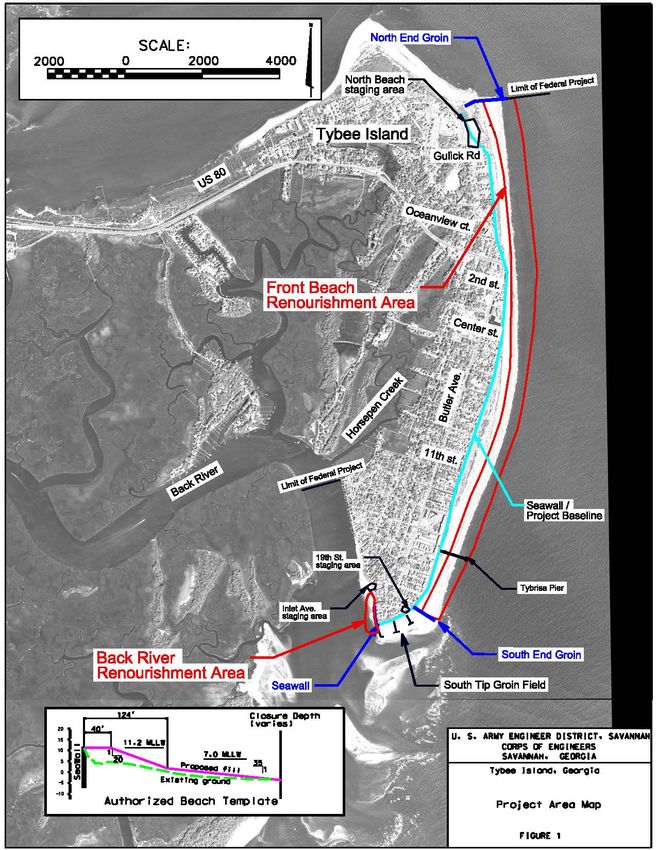
Draft Environmental Assessment
               Tybee Island Shore Protection Project, Georgia
                                          2015Renourishment

This page intentionally blank.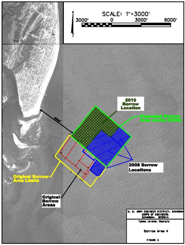
FINDING OF NO SIGNIFICANT IMPACT

Name of Action: Tybee Island Shore Protection Project, Georgia 2015 Renourishment

1. Project Description: The U.S. Army Corps of Engineers, Savannah District (Savannah
District) is proposing to perform a periodic renourishment to the Tybee Island Shore Protection
Project, an authorized Federal project. The project includes placing approximately 1,748,750
cubic yards (c.y.) of material on the beach at Tybee Island within the limits of the Federal
project. The exact quantity to be placed and the final project template will be determined based
on physical conditions and funds available at the time of construction.

2. Coordination: Savannah District will coordinate this project with Federal and State
resources agencies and the interested public and issue a Notice of Availability of the draft
Environmental Assessment (EA) in order to:

       a. Inform agencies and individuals of the proposed work and the environmental
evaluation contained in the draft EA, and

       b. Provide an opportunity for comments on that evaluation and findings.

3. Environmental Impacts:

       a. The proposed renourishment is very similar to what has previously been performed at
Tybee Island during the first periodic renourishment in 1987 by the Savannah District, the
subsequent 1995 work by Georgia Ports Authority (GPA), and the renourishments in 2000 and
2008, also conducted by the Savannah District, in that similar techniques and equipment will be
used.

        b. All previous renourishments at Tybee Island received required environmental
approvals. The U.S. Fish and Wildlife Service (USFWS) is preparing an updated Biological
Opinion (BO) to address nesting loggerhead sea turtles and leatherback sea turtles, non-breeding
piping plovers, and designated critical habitat for the piping plovers. The Atlantic Sturgeon, a
newly-listed species since the last renourishment was performed, will be analyzed in accordance
with the Endangered Species Act (ESA) for this renourishment, and an Essential Fish Habitat
(EFH) analysis will be submitted to the National Marine Fisheries Service (NMFS). The
Savannah District, USFWS, and NMFS concur that if recommendations to minimize take on
listed species are implemented as outlined in the USFWS BO and EFH, the renourishment may
affect, but is not likely to adversely affect listed species or designated critical habitat.

        c. The proposed action is in compliance with all environmental laws. Environmental
approvals/requirements are listed in Table 12 of this EA. Unavoidable adverse impacts to
benthic communities would occur as a result of the proposed project. Individual organisms
within the benthic communities would be lost as a result of the proposed excavation and
renourishment activities. However, benthic organisms would be expected to recolonize the
borrow area and beach. A layer of sandy sediment will be left at the surface of the borrow area

                                                 i
to encourage recolonization. Special conditions as described in the Final EA will be
incorporated into the construction contract and a watch and monitoring program will be
implemented to protect threatened and endangered species that may occur in the project area.

         d. The high compatibility and low percent fines of the borrow area sediment should
reduce turbidity levels during construction. A small turbidity plume is expected at the beach
discharge point in association with construction activities. However, this increase is not likely to
result in a violation of state water quality standards and should be temporary in nature.
Temporary shore-parallel dikes will be constructed in the immediate construction area as needed
to control the effluent and maximize the settling of sediments from the discharge before the
waters reach the Atlantic Ocean. Significant adverse cumulative impacts to water quality should
not occur as a result of this project.

        e. No adverse secondary impacts which have a significant probability of occurrence were
identified from either the proposed excavation or nourishment operations.

       f. Overall, the environmental impacts of implementing the proposed action are expected
to be minor in scope and temporary in duration.

4. Determination: I have determined that this action does not constitute a major Federal action
significantly affecting the quality of the human environment. Therefore, the action does not
require the preparation of a detailed statement under Section 102(2)(c) of the National
Environmental Policy Act (NEPA) of 1969 (42 U.S.C. 4321 et seq.). My determination was
made considering the following factors discussed in this EA:

       a. The proposed action has been designed to minimize impacts and avoid adverse
impacts to threatened or endangered species potentially occurring in the project area.

      b. No unacceptable adverse cumulative or secondary impacts would result from project
implementation.

        c. The work has been designed to avoid impacts to any potential cultural resources in the
project area.

       d. No additional long term adverse impacts to the environment would be associated with
the proposed project.

       e. No significant impacts on air quality are expected from the proposed project.

        f. The proposed action complies with Executive Order (EO) 12898, “Federal Actions to
Address Environmental Justice in Minority Populations and Low-Income Populations”, and does
not represent disproportionate high and adverse human health or environmental effects on
minority populations and low-income populations in the United States.

                                                 ii
g. The proposed action does not involve activities that would pose any disproportionate
environmental health risk or safety risk to children in accordance with EO 13045, Protection of
Children from Environmental Health Risks and Safety Risks (21 April 1997).

        h. No work will be performed before November 1, 2015 or after April 30, 2016, in order
to avoid impacts to nesting sea turtles without obtaining approval from Georgia Department of
Natural Resources, Coastal Resources Division.

5. Findings: The proposed Tybee Island Shore Protection Project 2015 Renourishment would
result in no significant adverse environmental impacts and is the alternative that represents sound
engineering practices and meets environmental standards.

Date                                                                Thomas J. Tickner
                                                                    Colonel, U.S. Army
                                                                    Commanding

                                                iii
2015 TYBEE ISLAND SHORE PROTECTION PROJECT
GEORGIA
DRAFT ENVIRONMENTAL ASSESSMENT
TABLE OF CONTENTS
Subject Page
FONSI ........................................................................................................................................ i
E.1.00. PURPOSE AND NEED FOR ACTION.................................................................................. 1
E.1.01. Background .......................................................................................................1
E.1.02. Scope and Authority .........................................................................................3
E.1.03. Project Description ...........................................................................................4
E.2.00. ALTERNATIVES ..................................................................................................................... 9
E.2.01. Without Project Condition ................................................................................9
E.2.02. Alternative B .....................................................................................................9
E.2.03. Recommended Alternative .............................................................................10
E.2.04. Fill Volumes ...................................................................................................10
E.2.05. Volumetric Changes .......................................................................................13
E.2.06. Borrow Site .....................................................................................................14
E.2.07. Future Periodic Renourishments.....................................................................15
E.2.08. Summary of Environmental Impacts to Project Area .....................................17
E.2.09 Summary of Conditions to Minimize Potential Adverse Impacts ..................17
E.3.00 ENVIRONMENTAL SETTING WITHOUT THE PROJECT ......................................... 21
E.3.01. Location ..........................................................................................................21
E.3.02. Geology/Physiography ...................................................................................21
E.3.03. Physical Factors ..............................................................................................22
E.3.03.1. Winds .............................................................................................22
E.3.03.2. Wave and Currents Climate ...........................................................22
E.3.03.3. Beach Slope ...................................................................................22
E.3.03.4. Tides ...............................................................................................22
E.3.04. Erosion History ...............................................................................................23
E.3.04.1. Oceanfront Area .............................................................................23
E.3.04.2. South Tip Beach .............................................................................23
E.3.04.3. Back River .....................................................................................23
E.3.04.4. Little Tybee Island .........................................................................24
E.3.05. Water Quality..................................................................................................26
E.3.06. Flora and Fauna ..............................................................................................27
E.3.07. Threatened and Endangered Species ..............................................................28
E.3.08. Borrow Area ...................................................................................................29
E.3.08.1. Sediment Characteristics ................................................................30
E.3.08.2. Contaminant Testing ......................................................................30
E.3.09. Coastal Barrier Island Resources ....................................................................32
E.3.10. Economics.......................................................................................................32
E.3.11. Historic Properties……………………………………………………………33
E.3.12. Air Quality……………………………………...……………………… .......33TABLE OF CONTENTS
(cont’d)
Subject Page
E.3.13. Noise.……..………………………………………………………………….33
E.3.14. Aesthetic Resources…………………………………………...……….…….33
E.3.15. Recreational Resources………………………………………………………34
E.3.16. Navigation…..……………………………………………………………..…34
E.3.17. Essential Fish Habitat………………………………………………….……..34
E.4.00. ENVIRONMENTAL CONSEQUENCES ...................................................................... …..35
E.4.01. Socio-Economic ....................................................................................……..35
E.4.02. Aesthetics…………………………………………………………………….35
E.4.03. Recreation…………………………………………………………………....36
E.4.04. Historic Properties……………………………………………………...……36
E.4.05. Coastal Barrier Island Resources…………………………………………….38
E.4.06. Floodplain Values…………………………………………….………..…….38
E.4.07. Air Quality……………………………………………………………….…..38
E.4.08. Noise…………………………………………………………………………38
E.4.09. Public Safety…………………………………………………………………38
E.4.10. Energy Requirements and Conservation…………………………..…..…….39
E.4.11. Natural or Depleted Resources………………………………………………39
E.4.12. Urban Quality…………………………………………………………..……39
E.4.13. Solid Waste…………………………………………………………….…….39
E.4.14. Drinking Water………………………………………………………………40
E.4.15. Water Quality………………………………………………………..………40
E.4.16. Wetlands……………………………………………………………..………40
E.4.17. Ground water….…………………………………………………………..…40
E.4.18. Fish and Wildlife………………………………………………………..…...41
E.4.18.1. Nearshore Soft Bottom Communities…………………………… 41
E.4.18.2. Onshore Soft Bottom Communities…………………………...… 42
E.4.18.3. Invasive Species…………………………………………………. 43
E.4.18.4. Shorebirds…….…………………………………………………. 44
E.4.19. Essential Fish Habitat Assessment ...................................................................51
E.4.20. Threatened and Endangered Species ................................................................52
E.4.20.1. No Action Alternative……………………………………………52
E.4.20.2. Recommended Alternative.............................................................52
E.4.21. Protection of Children and Environmental Justice .........................................55
E.4.22. Cumulative Impacts ........................................................................................56
E.4.23. Summary ........................................................................................................56
E.5.00. RELATIONSHIP OF PROJECT TO FEDERAL AND STATE AUTHORITIES ......... 57
E.6.00. COORDINATION .................................................................................................................. 59
E.7.00. LIST OF PREPARERS .......................................................................................................... 59
References ..................................................................................................................... 60
vLIST OF APPENDICES
Appendix Title
A Section 404 (1)(b) Evaluation
B Essential Fish Habitat
C Biological Assessment of Threatened and Endangered Species
D U.S. Fish and Wildlife Service Biological Opinion
LIST OF FIGURES
Figure Title Page
E-1 Project Area.....................................................................................................................2
E-2 Proposed Fill Limits ........................................................................................................7
E-3 Proposed Borrow Area ....................................................................................................8
E-4 Template Design Recommended Alternative ..............................................................11
E-5 Proposed Template .......................................................................................................12
E-6 Proposed Template including Critical Habitat Unit GA-1 ............................................20
E-7 Staging and Access Areas .............................................................................................37
LIST OF TABLES
Table Title Page
E-1 Anticipated Beach Fill Volumes to Replace Template ...................................................13
E-2 Summary of Environmental Consequences.....................................................................16
E-3 Chronology of Recent Beach Renourishment and Erosion Control Efforts....................25
E-4 Federal Threatened and Endangered Species ..................................................................29
E-5 Sediment Characteristics of Composite Profiles above -16 feet MLW ..........................30
E-6 Results of Heavy Metal Analysis of Expanded Borrow Area .........................................31
E-7 Results of Entire Beach Shorebird Surveys.....................................................................45
E-8 Results of Critical Habitat Unit GA-1 Shorebird Surveys ..............................................46
E-9 Mean Results of Critical Habitat Shorebird Surveys ......................................................48
E-10 Results of DNR Shorebird Winter Surveys 1999-2012 ..................................................50
E-11 Compliance with Environmental Regulations .................................................................57
viDraft Environmental Assessment
Tybee Island Shore Protection Project, Georgia
2015Renourishment
2015 TYBEE ISLAND SHORE PROTECTION PROJECT
DRAFT
ENVIRONMENTAL ASSESSMENT
DECEMBER 2013
E.1.00. PURPOSE AND NEED FOR ACTION
The purpose of this document is to evaluate the environmental impacts of the proposed beach
renourishment for the Tybee Island Shore Protection Project on Tybee Island, Georgia. The
proposed renourishment is very similar to what has previously been performed at Tybee Island
during the first nourishment in 1987, the subsequent 1995 work by Georgia Ports Authority
(GPA), and the renourishments in 2000 and 2008 in that similar techniques and equipment will
be used.
E.1.01. BACKGROUND
Tybee Island is located 17 miles east of Savannah at the mouth of the Savannah River on the
Atlantic Ocean. The highly developed island is bordered on the north by the South Channel of
the Savannah River, on the east by the Atlantic Ocean, and on the south and west by the Back
River and other tidal creeks. Tybee Island has an average width of 0.5 miles and the ground
elevation varies from 10 to 18 feet above Mean Lower Low Water (MLLW) and slopes
westward to the salt marshes. Figure 1 is a map of the project area.
This authorized 3.5 mile long project was initially constructed in 1974 with a 50-year project life
and periodic renourishments to occur every 7 years. The beach was last renourished in 2008 and
is scheduled to be renourished again in 2015. In 2015, there will be 9 years left in the project life
(i.e. Federal participation). The Savannah District, with the non-Federal sponsor’s concurrence,
selected to perform the 2015 periodic renourishment for the remaining 9 years of the 50-year
project life. The renourishment volume to be placed includes the volume needed to restore the
project plus an additional 312,000 cubic yards to account for potential erosion through 2024.
The beach template will be slightly modified to include placement of the additional material by
extending the berm up to the North terminal groin of the template. This area has been nourished
during previous renourishment cycles, but not during the 2008 renourishment. In addition, the
berm will be extended seaward up to 50 feet beyond the previously constructed template to
account for erosion during the additional 2 years for a 9 year cycle. The same borrow area that
was used for the 2008 renourishment, Borrow Area 4, will be used for this final renourishment.
Table 3 provides a history of previous beach nourishments.
1Draft Environmental Assessment
Tybee Island Shore Protection Project, Georgia
2015Renourishment
Figure 1: Location Map, Tybee Island, Georgia
(Source: Bing Maps Hybrid 2010)
2Draft Environmental Assessment
Tybee Island Shore Protection Project, Georgia
2015Renourishment
E.1.02. Scope and Authority
The original Tybee Island Beach Erosion Control Project was authorized in June 1971 by Senate
and House resolutions pursuant to Section 201 of the Flood Control Act of 1965 (Public Law 89-
298), as presented in House Document No. 92-105, for a life of 10 years. Section 201 provided a
procedure for authorization of projects with, at that time, an estimated Federal first cost of
construction of less than $10 million. The authorizing language reads as follows:
“RESOLVED BY THE COMMITTEE ON PUBLIC WORKS OF THE UNITED STATES
SENATE, That pursuant to the provisions of Section 201 of Public Law 298, Eighty-ninth
Congress, (79 Stat. 1073; 42 U.S.C. 1962d-5) the project providing for beach erosion
control on Tybee Island, Georgia, is hereby approved substantially in accordance with the
recommendations of the Secretary of the Army and the Chief of Engineers in House
Document Numbered 105, Ninety-second Congress, at an estimated cost of $404,000.”
The authority for Federal participation in periodic renourishment of beach projects was increased
from 10 years to 15 years by Section 156 Water Resources Development Act (WRDA) 1976,
which reads as follows:
"The Secretary of the Army, acting through the Chief of Engineers, is authorized to
provide periodic beach nourishment in the case of each water resources
development project where such nourishment has been authorized for a limited
period for such additional periods as he determines necessary but in no event shall
such additional period extend beyond the fifteenth year which begins after the date
of initiation of construction of such project."
Section 934 of WRDA 1986 modified Section 156 of WRDA 1976 by extending the authority
for Federal participation in periodic renourishment from 15 years to 50 years and reads as
follows:
"Section 156 of the Water Resources Development Act of 1976 (42 U.S.C. 1962d-
5f) is amended by striking out "fifteenth" and inserting in lieu thereof "fiftieth."
Following the passage of WRDA 1986, Savannah District prepared a “Section 934” report which
concluded that the authorized Federal project for Tybee Island was economically feasible under
then current policy and economic guidelines, and the project should be extended for the
remaining life of 30 years (from 1994). The study was initiated in 1990, completed in October
1994 and approved in June 1995. The project life of the Tybee Island Beach Erosion Control
Project began in September 1974, with initiation of construction of the North Terminal Groin,
and, therefore, extends through September 2024.
The Federal project was further modified by Section 301 of WRDA 1996, which amended the
authorized project as follows:
3Draft Environmental Assessment
Tybee Island Shore Protection Project, Georgia
2015Renourishment
“The project for beach erosion control, Tybee Island, Georgia, authorized
pursuant to section 201 of the Flood Control Act of 1968 (42 U.S.C. 1962d-5; 79
Stat. 1073-1074) is modified to include as an integral part of the project the
portion of Tybee Island located south of the existing south terminal groin between
18th and 19th Streets, including the east bank of Tybee Creek up to Horse Pen
Creek.”
By letter dated 14 March 1997, Headquarters, U.S. Army Corps of Engineers (HQUSACE)
authorized a study to determine if the South Tip Beach and Tybee Creek up to Horse Pen Creek
should be added to the authorized Tybee Island Beach Erosion Control project. The “Special
Report on South Tip Beach/Tybee Creek” was completed in May 1998 in response to this
authority and was approved by HQUSACE in August 1998. The report recommended extending
the southern limits of the authorized project for an additional 1,100 feet to provide protection for
structures along the South Tip and another 1,800 feet to provide protection to the northern bank
of the Back River/Tybee Creek.
E.1.03. Project Description
The authorized project consists of nourishment of 13,200 linear feet of beach between two
terminal groins (referred to as Oceanfront Beach); construction of a groin field along 1,100 linear
feet of shoreline from the southern terminal groin around the South Tip to the mouth of Tybee
Creek (also known as Back River) including periodic nourishment (referred to as South Tip
Beach); and construction of a groin field and nourishment of 1,800 linear feet of the eastern bank
of Tybee Creek to the city fishing pier (referred to as Back River Beach). The remaining
shoreline from the fishing pier to the mouth of Horse Pen Creek, although included in the
authorizing language of WRDA 1996, is relatively stable at this time and no hurricane and storm
damage protection measures have been constructed in this reach. The existing approved Borrow
Area 4 will be used for this renourishment.
The borrow area is 7,000 feet southeast of the southern tip of Tybee Island. This borrow area
was used by GPA for the 1994 beach nourishment, and again by the Savannah District for the
2001 and 2008 renourishments. The area was expanded to the north for the 2008 renourishment
project.
As proposed, the project will be constructed using a hydraulic cutterhead pipeline dredge and
support equipment. A submerged pipeline will extend from the borrow site to the southerly tip of
Tybee Island. Shore pipe will be progressively added to perform fill placement along the
shorefront or creekfront areas to be renourished. The contractor will not impinge on beach dunes
during construction as work will be conducted from the existing beach and newly placed
material. Temporary toe dikes will be utilized in a shore parallel direction to control the
hydraulic effluent and reduce turbidity. The sand will be placed in the form of varying design
templates based upon longshore volumetric fill requirements which reflect beach conditions at
the time of construction. Additional beach fill will be strategically placed in areas of
4Draft Environmental Assessment
Tybee Island Shore Protection Project, Georgia
2015Renourishment
documented highest erosional stress such as the 2nd Street “hot spot”. Figure 2 shows the
proposed fill limits and locations.
The proposed sand source for this renourishment is the same borrow area that was used for the
2008 renourishment. However, different locations within the same borrow area will be utilized.
The borrow area is located approximately 7,000 feet (1.3 miles) southeast of the southernmost
Federal terminal groin. Figure 3 shows the location of the borrow area. The NW facing side of
the 2015 borrow location is 3900 ft (long edge toward Tybee). The NE facing side of the 2015
borrow location is ~3160 ft (long edge facing the ocean.) The total area of the proposed 2015
borrow area (dark green hatch) is ~213 acres. Total area of the blue hatched area of 2008 borrow
locations is ~256 acres. Total of yellow "original borrow area limits" is ~298 acres.
The USACE 1994 Section 934 report evaluated 26 combinations of alternate berm widths (40 to
70 feet), berm heights (+11.0 to +17.0 feet), and beach slopes. This provided a variety of
potentially feasible widths and heights. Five alternate berm widths and heights were selected for
detailed evaluation, and costs and benefits were computed for each of the alternatives. The
analysis concluded a 40-foot wide berm at elevation +11.0 with 1V:20H slope was the most
desirable oceanfront beach template for all nourishments.
In the 1998 Environmental Assessment for South Tip Beach/Tybee Creek, it was concluded that
in order to maintain the integrity of the restored beach at Back River between periodic
renourishment, advance nourishment would be provided by placing fill material one foot above
the beach template, up to elevation 12 feet Mean Low Water (MLW) and providing additional
material on the beach slope. A berm elevation of +12 feet MLW and 1V:15H slope was
proposed for the Back River/Tybee Creek segment of the proposed renourishment project.
The proposed project template design is based on project performance and erosion rates since the
last renourishment project in 2008. Beach fill will primarily be placed in areas included in the
previous renourishment in 2008. These areas include the North Beach (North End Groin to
Oceanview Court), Second Street area (Oceanview Court to Center Street), Middle Beach
(Center Street to 11th Street), South Beach (11th Street to South End Groin), and Back
River/Tybee Creek (South Tip Groin Field to Inlet Avenue). Additional fill will be placed
between these areas to provide a more stable beach profile and to avoid some of the excessive
losses in the 2nd Street “hot spot” from project end losses and offshore losses that resulted from
the wide beach constructed at this location during the last renourishment. Constructed beach
widths on the Back River Beach vary from 30 feet to 110 feet at +11.22 MLLW. Beach widths
on the Oceanfront Beach will vary from a 25-foot width berm, to a berm approximately 350 feet
wide at the elevation of +11.22 MLLW. Based on natural angle of repose on the existing beach,
and experience with previous placement, a beach slope of 1 vertical on 25 horizontal will be
required on the oceanfront beach. The Back River will have an 11.2 foot elevation MLLW and a
1V:15H slope. Figures 4 and 5 show the proposed design template.
Beach fill final placement will be based on physical conditions and funds available at the time of
construction. Alternative bid schedules will be used to optimize the quantity of beach fill placed
5Draft Environmental Assessment
Tybee Island Shore Protection Project, Georgia
2015Renourishment
for the funds available. The proposed project is expected to commence by November 2015, and
be completed by April 30, 2016. Federal participation in the Federal project expires in 2024, 9
years after the time of the proposed construction.
6Draft Environmental Assessment
Tybee Island Shore Protection Project, Georgia
2015Renourishment
Figure 2: Proposed Fill Limits For 2015 Tybee Beach Renourishment
7Draft Environmental Assessment
Tybee Island Shore Protection Project, Georgia
2015Renourishment
Figure 3: Proposed Borrow Area
8Draft Environmental Assessment
Tybee Island Shore Protection Project, Georgia
2015Renourishment
E.2.00. ALTERNATIVES
This chapter describes the alternatives and summarizes the environmental consequences for the
proposed action including the Without Project Condition.
E.2.01. WITHOUT PROJECT CONDITION (NO ACTION)
This alternative would result in continued erosion to the Tybee Island Shore Protection Project,
including potential loss of property and structures. Since December 2008 an average loss of
approximately 164,000 cy/yr has occurred on the oceanfront beach. The majority of erosion
occurred at the Second Street “hot spot” with a lesser degree of erosion in the vicinity of the
Tybrisa Pier. With no renourishment, the beach would continue to erode, with a concomitant loss
in storm damage protection and recreational benefits. In addition, if erosion were to be allowed
to continue unimpeded, seawall and dune damage would be expected to occur at an accelerated
rate.
E.2.02. ALTERNATIVE B. BEACH RENOURISHMENT
The proposed project template design is based on project performance and erosion rates since the
last renourishment project in 2008. Beach fill will primarily be placed in areas included in the
previous renourishment in 2008. These areas include the Oceanfront North Beach from the north
terminal groin to Center Street, the Oceanfront South Beach from 11th Street to the South End
Terminal (Federal) Groin, and the Back River Beach from Inlet Avenue to Southernmost end of
Groin G-1 in the South Tip Groin Field (Figure 2). Additional fill will be placed between these
areas to provide a more stable beach profile and to avoid some of the excessive losses in the 2nd
Street “hot spot” from project end losses and offshore losses that resulted from the wide beach
constructed at this location during the last renourishment. Constructed beach widths on the Back
River Beach vary from 30 feet to 110 feet at +11.22 MLLW. Beach widths on the Oceanfront
Beach will vary from a 25 foot width berm, to a berm approximately 350 feet wide at the
elevation of +11.22 MLLW. Based on natural angle of repose on the existing beach, and
experience with previous placement, a beach slope of 1 vertical (V) on 25 horizontal (H) will be
required on the oceanfront beach. The Back River will have an 11.2 foot elevation MLLW and a
1V:15H slope (Figures 4 and 5). The constructed berm width is calculated to protect the
authorized template for 9 years.
The recommended fill volume would be for placement of approximately 1,748,750 cubic yards
(c.y.) within the limits of the Federal Project. For this alternative, approximately 350,000 c.y. of
fill would be placed at the 2nd Street erosional “hot spot”, 150,000 c.y. of material on the Middle
Beach, 190,000 c.y. on South Beach and 8,000 c.y. of material on the Back River Beach (Table
1). These volumes represent project requirements to take the project to the end of its 50-year
life. Dependant on funding available at the time of construction and uncertainties in
renourishment prices, alternate bid schedules may be included for smaller projects to assure the
maximum project can be awarded at an acceptable price.
9Draft Environmental Assessment
Tybee Island Shore Protection Project, Georgia
2015Renourishment
E.2.03. RECOMMENDED ALTERNATIVE
Beach renourishment, Alternative B, is the selected alternative. Based on previous studies and
the current condition of the beach it is apparent that taking no action would continue to result in
erosion of the beach at Tybee Island. The 1,748,750 c.y. alternative is considered to be the
design fill volume required for protection of the total authorized Federal beach template for the
next 9 years.
E.2.04. FILL VOLUMES
The next periodic renourishment for the project is scheduled to occur in Fiscal Year (FY) 2015.
The actual start date of construction is subject to appropriation of Federal funds. At that time,
the volume of material eroded from the beach would be replaced with the amount such that the
beach template would be protected until the end of the project life in 2024. Rather than initiating
a project to place 2 years of fill on the beach in 2022, an additional 2 years of advance
nourishment will be placed on the beach in FY15 to carry the project to the end of the project life
in 2024. The fill will be shoreward of the previous berm and in a uniform manner over the beach
length to prevent excessive erosion in the fill. The fill volumes shown in Table 1 are in-place
volumes, unless stated otherwise. The Back River Groin field consists of 7 groins, the shoreline
length of 5 groins is 100 feet, and 2 groins are 50 feet long – designed to extend into the breaker
zone and intercept the longshore transport of material in the littoral zone (1998 South Tip
Report). Table 1 shows the anticipated design volumes for the 2015 renourishment.
10Draft Environmental Assessment
Tybee Island Shore Protection Project, Georgia
Figure 4: Template Design for Recommended Alternative 2015Renourishment
11Draft Environmental Assessment
Tybee Island Shore Protection Project, Georgia
2015Renourishment
Figure 5: Proposed Template*
*Back River Beach will have a slope of 1V:15H
12Draft Environmental Assessment
Tybee Island Shore Protection Project, Georgia
2015Renourishment
Table 1.
Quantity to Fill Design Template
(Based On September 2012 Survey for 2015 Renourishment)
REACH LOCATION ANTICIPATED FILL
VOLUME*
R1 North Beach (North End Groin to Oceanview Court) 305,000 yd3
R2 Second St renourishment area (Oceanview Court to 670,000 yd3
Center Street)
R3 Middle Beach (Center Street to 11th Street) 170,000 yd3
R4 South Beach (11th Street to South End Groin) 225,000 yd3
R5 Back River/Tybee Creek (South Tip Groin Field to 29,000 yd3
Inlet Avenue)
Total 1,399,000 yd3
Anticipated dredging volume (assuming 20% loss 1,748,750 yd3
during placement)
* includes volume to replace erosion since last renourishment, plus erosion anticipated
before the 2015 renourishment (156,000 cy per year based on long term erosion
rates between 2001 and 2012), and an additional 312,000 yd3 to cover 2 additional
years of fill. The highest density of fill will be placed on the Second
Street Beach, in the area with the highest long term erosion rate.
E.2.05. VOLUMETRIC CHANGES
The September 2012 survey provided by the City of Tybee Island is the most recent beach
profile survey for the project area. Recent surveys have substantiated the long term erosion rate,
with an average of approximately 164,000 cy/yr erosion on the oceanfront beach between
completion of the last renourishment (2008) and September of 2012. The majority of this
erosion occurred at the Second Street “hot spot” with a lesser degree of erosion in the vicinity of
the Tybrisa Pier.
Erosion on the Back River Beach is concentrated in the area of the seawall. Erosion in this area
since the last renourishment was approximately 8,000 c.y. A beach monitoring program would
continue in order to document the effectiveness of the beach nourishment and to more accurately
predict future renourishment volumes.
13Draft Environmental Assessment
Tybee Island Shore Protection Project, Georgia
2015Renourishment
E.2.06. BORROW SITE
Borrow area 3 was the original borrow area used for the 1976 and 1987 beach nourishments and
is located 3,200 feet south of the southern tip of the Island. This site was selected prior to the
passing of the Coastal Barrier Resources Acts (COBRA) of 1982 and 1990 which are
administered by the Department of Interior (DOI) USFWS. Borrow area 4 was first utilized in
1995 by the Georgia Ports Authority for partial beach nourishment. This borrow area was 142
acres and divided into five cells ranking in excavation priority (A,B,C,D,E). During the 1995
nourishment only cell A was used. Prior to the 2000 nourishment borrow area investigations
discovered magnetic anomalies in cell A (likely dredging equipment from the 1995 nourishment)
making it unsuitable for use in the 2000 project. An extensive study was conducted of the
remaining cells and it was determined that the existing borrow area did not contain enough
known suitable material to complete the project. Borrow area 4 was expanded in a northwesterly
direction toward Tybee, staying outside the COBRA line, and two new areas, cells F (63 acres)
and G (39 acres), were approved for inclusion into the now expanded borrow area 4. Complete
details on the borrow area history and expansion may be found in the U.S. Army Corps of
Engineers May 1998 Special Report on South Tip Beach/Tybee Creek Portion of Tybee Island
Beach Erosion Control Project Georgia.
The proposed offshore borrow site is the same site that was used during the 2008 renourishment,
borrow area 4. The previously used borrow area lies approximately 1.3 miles (~7,000 feet)
southeast of the southernmost Federal terminal groin (Figure 3). Recent cultural resource
surveys found no evidence for potentially significant resources in the borrow area (Panamerican
Consultants, Inc. 2013).
Sediment compatibility analyses were performed for the previously authorized borrow site
located immediately adjacent and south of the proposed expansion area. The geotechnical
evaluation demonstrated that the sediment characteristics were typical of ebb tidal shoal and
highly compatible with the existing beach sediments of Tybee Island (ATM 1994, Olsen, 2008).
A layer of sandy sediment will be left at the surface of the borrow area to encourage
recolonization.
Based on the report Entitled "Tybee Island, Georgia Beach Renourishment Project, 2007
Geotechnical Investigation" (Olsen Associates Inc., March 2008) the previously approved
borrow area still has high quality material available for nourishment. Within the remaining
portions of the borrow area approximately 84% of core samples have less than 1% fines to a
depth of -16 feet MLLW. This is considered very high quality beach compatible sediment. The
remaining 16% of core samples have between 1% and 4% fine material, with the highest fines
content being at 3.5%. This is still considered high quality beach sediment. The average percent
shell content is very similar to the existing beach, 9.9 % to -16 feet MLLW as compared to
12.6% on the existing beach.
14Draft Environmental Assessment
Tybee Island Shore Protection Project, Georgia
2015Renourishment
E.2.07. FUTURE PERIODIC RENOURISHMENTS
If the project is extended past 2024 a new environmental assessment and a new authorization
will be required that addresses continued Federal participation in the project.
E.2.08. SUMMARY OF ENVIRONMENTAL IMPACTS OF THE PROPOSED ACTIONS
Potential adverse impacts identified for the proposed actions includes impacts to:
• Water quality
• Fishery resources
• Benthic communities
• Endangered and Threatened Species
• Shorebirds, waterfowl and other wildlife
• Recreation
• Aesthetics
• Air Quality
Table 2 shows comparative environmental impacts between the No Action Alternative and the
recommended alternative.
15Draft Environmental Assessment
Tybee Island Shore Protection Project, Georgia
Table 2. Summary of Environmental Consequences 2015Renourishment
Environmental Factor Recommended Alternative No Action Alternative
Water Quality Temporary increase in localized No impacts
turbidity
Fisheries Short-term impacts to surf zone fishes No impacts
due to increased turbidity and loss of
habitat during construction
Benthics Major but short-term effects on benthic No impacts
communities due to offshore dredging
and nearshore placement
Endangered and Minor and short-term if construction Loss of habitat due to erosion
Threatened Species occurs in recommended time period and
if contract conditions are followed
Wildlife Minor effect Minor effect
Wetlands No impact No impact
Cultural Resources No impact if magnetic No impact
anomalies are avoided and protected
Recreation Benefits Temporary decrease during Negative impact due to loss
renourishment but long term positive of recreational beach
benefit
Aesthetics Temporary negative effect during Negative effect due to loss of
construction but long-term positive beach
effect
Storm Damage Reduction Increased protection from storm erosion Negative effect due to
Benefits continued beach loss
Erosion Control Benefits Positive effect due to renourishment None
Public Safety Temporary increased risk during Increased risk due to erosion
renourishment due to dredge/heavy (larger waves, change in
equipment bathymetry)
Air Quality Temporary decrease due to equipment No impact
discharge
Vegetation No impact Negative effect due to loss of
substrate
Energy Requirements and Insignificant energy requirements for No impact
Conservation beach renourishment
Hazardous Waste No impact No impact
16Draft Environmental Assessment
Tybee Island Shore Protection Project, Georgia
2015Renourishment
E.2.09. SUMMARY OF CONDITIONS TO MINIMIZE POTENTIAL ADVERSE IMPACTS
To minimize potential adverse impacts to sea turtles and to protect larval and estuarine fishery
resources, the District will attempt to schedule the majority of the work between November and
30 April. This construction window will avoid impacts to nesting sea turtles, migratory West
Indian manatees, and benefit juvenile life stages of fishery species that are likely present in
warmer months. The District will abide by Section 7 of the Endangered Species Act (Act) [16
U.S.C. 1531 et seq.] which outlines the procedures for Federal interagency cooperation to
conserve Federally listed species and designated critical habitats. Through consultation with the
District in 2008, a Biological Opinion (BO) was issued by USFWS to addresses the project’s
impacts to non-breeding piping plovers, critical habitat for the piping plover, and nesting
loggerhead and leatherback sea turtles. A new BO may be developed for this renourishment.
The District will consider any new Reasonable and Prudent Measures and implement measures
to minimize take in this proposed renourishment. The 2008 BO concluded the project was not
likely to jeopardize the continued existence of the loggerhead or leatherback sea turtles or the
piping plover. No adverse modifications were determined for piping plover Critical Habitat Unit
GA-1. The following Reasonable and Prudent Measures were recommended and implemented
to minimize take of the above listed species:
The USACE included in their proposed action conservation measures to minimize the effects of
this action on sea turtles and piping plovers:
1. Construction equipment and materials will be staged and stored in a manner that will
minimize impacts to sea turtles and piping plovers to the maximum extent practicable.
2. Existing beach access points will be used for vehicle and equipment beach access to the
maximum extent practicable. Existing vegetated habitat at the beach access points must be
protected to the maximum extent practicable. The access must be delineated by fence or
other suitable material to ensure vehicles and equipment transport stay within the access
corridor.
3. Shorebird monitoring will be performed to detect piping plovers or concentrations of
other shorebirds once a month for the entire beach and another time during the month on
the critical habitat on the north part of the island. This will be done prior to and during the
construction activities.
The Service believes the following reasonable and prudent measures are necessary and
appropriate to minimize take of nesting and hatchling loggerheads and leatherbacks and non-
breeding piping plovers in the proposed areas of dredged material placement and associated
activities in the action area.
1. If the beach renourishment project extends into the sea turtle nesting season (beyond
April 30), surveys for nesting sea turtles must be conducted daily before work is begun. If
nests are constructed in the area of beach renourishment, the eggs must be relocated to
minimize sea turtle nest burial, crushing of eggs, or nest excavation.
17Draft Environmental Assessment
Tybee Island Shore Protection Project, Georgia
2015Renourishment
2. Immediately after completion of the beach renourishment project and prior to the next
three nesting seasons, beach compaction must be monitored and tilling must be conducted
as required to reduce the likelihood of impacting sea turtle nesting and hatching activities,
and foraging, roosting and loafing piping plovers. (If tilling is needed, it must only occur
above the primary wrack line.)
3. Immediately after completion of the beach renourishment project and prior to the next
three nesting seasons, monitoring must be conducted to determine if escarpments are
present and escarpments must be leveled to reduce the likelihood of impacting sea turtle
nesting and hatching activities.
4. Disturbance to piping plover Critical Habitat GA-1 by the USACE beach nourishment
project will be minimized. Surveys for piping plovers must be done within the action area
to document the continued use of the Critical Habitat GA-1, as well as, the remaining
action area. The amount of pedestrian traffic and unleashed pet occurrences should also be
recorded.
5. Lighting associated with the project night work must be minimized to reduce the
possibility of disrupting and disorienting nesting and/or hatchling sea turtles and piping
plover roosting activities.
6. A survey of all lighting visible from the renourished beach shall be completed using
standard techniques for such a survey.
7. The USACE shall ensure that contractors conducting the beach nourishment work fully
understand the sea turtle and piping plover protection measures detailed in this incidental
take statement.
A new or updated Biological Opinion may be issued for this project during Pre-Construction
Engineering and Design (PED) phase to address any changes that may have occurred since the
2008 renourishment.
NMFS provided the following EFH conservation recommendations which were implemented
during the 2008 project:
1. The borrow area shall be mined selectively to reduce the amount of silt and shell placed
on the beach. A monitoring program shall be implemented to document any changes to
sediment texture along the beach and to characterize, relative to reference areas, the
abundance and fishery value of infauna within the fill area. The monitoring plans shall
be submitted to NMFS for approval prior to construction.
2. Bathymetric surveys shall be conducted immediately after and one year after project
completion to demonstrate compliance with dredging depth restrictions and to
18Draft Environmental Assessment
Tybee Island Shore Protection Project, Georgia
2015Renourishment
demonstrate the borrow areas are filling at rates presumed acceptable for fishery
resources.
3. A monitoring program shall be implemented at the borrow area to document filling
rates, nature of the material that fills the pit, and the impact the pit has on the use of the
sea bottom by fish. The monitoring plans shall be submitted to NMFS for approval
prior to construction.
The Atlantic sturgeon is a newly- listed endangered species since the last renourishment in 2008.
Conditions to minimize impacts to the sturgeon include time of year restrictions, an endangered
species watch plan with trained observers on watch during all times of waterborne construction
activities, and employing a cutterhead dredge (which has been shown to have a low likely hood
of take). The proposed project will impact critical habitat unit GA-1 for the wintering piping
plover by placing a small amount of fill in the area. A watch plan to ensure plovers are not
harmed will be utilized. Construction activities will be re-routed or stopped if plovers are in the
vicinity of the work area. The USFWS 2008 BO contains recommendations which will be
implemented to minimize impacts to the piping plover and reflect any changes from the new BO
being developed. The Georgia Department of Natural Resources (GA DNR) requires beach
construction to occur outside the sea turtle nesting season (May 1 – October 31). However,
nesting data from Tybee indicate the season is generally over by mid-September. The proposed
construction timeline for this project is November 2015 through February 2016. Any agreements
concerning renourishment during nesting season would include a requirement that appropriate
nest relocation procedures be followed, if necessary, to prevent impacts to nesting turtles. In
addition, the USFWS has outlined conditions to regulate construction activities during sea turtle
nesting season in their 2008 BO (Appendix D). The District will include these conditions in any
contract for construction.
19Draft Environmental Assessment
Tybee Island Shore Protection Project, Georgia
2015Renourishment
Figure 6: Proposed Template Showing Overlap into Piping
Plover Critical Habitat
20Draft Environmental Assessment
Tybee Island Shore Protection Project, Georgia
2015Renourishment
The beach will be tilled and monitored for sand compaction and beach profile immediately after
construction (2015/2016) and monitored for three years after construction (2016-2018/2019),
including the first winter/spring following completion of construction, to determine post-
nourishment compaction and need for additional removal of escarpments. Only areas of
compaction greater than 500 cone penetrometer index units (cpu), including escarpments greater
than 18 inches high by 100 feet long, need to be mechanically tilled or leveled. Escarpments that
are not compacted should not be mechanically leveled regardless of their size as they do not
present a problem to sea turtles. Compaction testing will be conducted by qualified USACE
personnel and GA DNR biologists. After the 2008 renourishment the beach was tilled in March
2009 and March 2010. Compaction testing in March 2011 did not indicate tilling was necessary.
Tilling was conducted in April 2012.
The material needed for the proposed alternatives will be excavated from the borrow area and
placed on the beach areas by hydraulic cutterhead pipeline dredge. The 1997 National Marine
Fisheries Service Biological Opinion on hopper dredging in the southeast found that hopper
dredging was much more likely than pipeline dredging to result in adverse impacts to sea turtles
and sturgeon. The use of a hydraulic cutterhead pipeline dredge would minimize potential
adverse impacts to sea turtles and sturgeon. Conditions to avoid potential adverse impacts to
threatened and endangered species that might occur in the general project area will be added to
any contract issued for the work. These conditions are explained in detail in Section E4.20.2 of
this EA and in Appendix C, Biological Assessment of Threatened and Endangered Species
(BATES) and the 2008 Biological Opinion (BO) from USFWS, Appendix D.
E.3.00. ENVIRONMENTAL SETTING WITHOUT THE PROJECT
E.3.01. LOCATION
Tybee Island is one of a series of barrier islands lying along the Atlantic coast from Florida to
North Carolina. The island is located directly south of the Savannah River entrance, about 17
miles east of the city of Savannah, Chatham County, Georgia. It is bounded on the north by the
Savannah Harbor, to the east by the Atlantic Ocean, and on the south and west by Tybee Creek
and a vast tidal marsh system. The major portion of the land mass above high tide is occupied by
the City of Tybee Island. The City of Tybee Island is the only population center on the island
with the major portion of its economy primarily oriented toward support facilities which service
summer vacationers.
The study area includes the North Beach, Second Street, Middle Beach, South Beach and Back
River.
E.3.02. GEOLOGY/PHYSIOGRAPHIC SETTING
The coastal barrier islands of Georgia are erosional remnants of Pleistocene coastal sand bodies
extending from the mainland toward the Atlantic Ocean. Characteristic development includes
oceanward frontages of beach dune ridges constructed during the present or Holocene high sea
21You can also read