Drones: applications and compliance for surveyors - RICS insight paper - rics.org/insights
←
→
Page content transcription
If your browser does not render page correctly, please read the page content below
RICS insight paper

Drones: applications and
compliance for surveyors

May 2019

                      rics.org/insights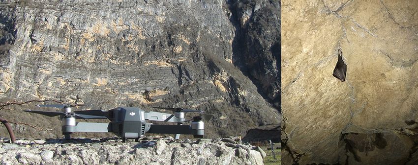
rics.org/insights

Drones: applications and
compliance for surveyors

May 2019

Copyright acknowledgments
Figure 2 is reproduced with permission from Sensefly
Figures 3–6 are reproduced with permission from SLR Consulting
Contains public sector information licensed under the Open Government Licence v3.0.

Published by the Royal Institution of Chartered Surveyors (RICS)
RICS, Parliament Square, London SW1P 3AD
www.rics.org
ISBN 978 1 78321 355 9
The views expressed by the authors are not necessarily those of RICS nor any body
connected with RICS. Neither the authors, nor RICS accept any liability arising from the
use of this publication.
All rights reserved. No part of this publication may be reproduced or transmitted in
any form or by any means, electronic or mechanical, including photocopy, recording,
or any information storage and retrieval system, without permission in writing from the
publisher.
Copyright RICS 2019
Typeset using Typefi
Drones: applications and compliance for surveyors

                                      Acknowledgments

                                      Author
                                      Peter Kinghan MRICS
                                      Professional Group Lead
                                      James Kavanagh FRICS
                                      Publishing team
                                      Project manager: Ellie Scott
                                      Editor: Katie Pattullo

                                      With special thanks to:
                                      Jon Mills (University of Newcastle and International Society
                                      for Photogrammetry and Remote Sensing)
                                      Robert Garbett (Drone Major Group)
                                      James Dunthorne (Association of Remotely Piloted Aircraft
                                      Systems UK)
                                      Charlton Bland (Atkins)
                                      Mark Lawton (Chartered Institution of Civil Engineering
                                      Surveyors)
                                      Rory Stanbridge (The Survey Association)
                                      Clive Boardman (The Survey Association)
                                      Richard Armitage (Remote Sensing and Photogrammetry
                                      Society, CAA and BSI)

ii RICS insight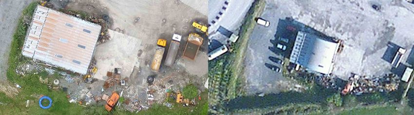
rics.org/insights

           Contents

           Acknowledgments ������������������������������������������������������������������������������� ii
           Foreword ������������������������������������������������������������������������������������������������ 1
           Glossary �������������������������������������������������������������������������������������������������� 2
           1 Introduction ����������������������������������������������������������������������������������� 5
             1.1 Types of drones ��������������������������������������������������������� 6
             1.2 Size of the drone industry ������������������������������������������ 7
           2 Opportunities and challenges ������������������������������������������������ 9
             2.1 Opportunities ������������������������������������������������������������� 9
             2.2 Challenges �������������������������������������������������������������� 10
           3 Sensors and drone innovation �������������������������������������������� 11
             3.1 Cinema/video ����������������������������������������������������������                           11
             3.2 Optical cameras ������������������������������������������������������                            12
             3.3 Thermal �������������������������������������������������������������������                       13
             3.4 LiDAR ����������������������������������������������������������������������                      14
             3.5 Optical gas imaging �������������������������������������������������                             14
             3.6 Multispectral ������������������������������������������������������������                        14
             3.7 Hyperspectral ����������������������������������������������������������                          15
           4 Potential uses of drones ���������������������������������������������������������                    16
             4.1 Use of drones in urban environments �����������������������                                       16
             4.2 Environmental monitoring ����������������������������������������                                 17
             4.3 Humanitarian and sustainable development �������������                                            17
             4.4 Monitoring of volcanoes �������������������������������������������                               17
           5 Drone regulations ����������������������������������������������������������������������              19
             5.1 General aviation rules ����������������������������������������������                             19
             5.2 Commercial regulations �������������������������������������������                                20
             5.3 Jurisdiction-specific legislation ���������������������������������                               22
             5.4 Future rules and regulations �������������������������������������                                23
             5.5 Standards ����������������������������������������������������������������                        24
           6 Using drones in your business ���������������������������������������������                           25
           7 Conclusion ������������������������������������������������������������������������������������ 27
           8 References ����������������������������������������������������������������������������������� 28
           9 Further reading ��������������������������������������������������������������������������� 29

May 2019                                                                                           RICS insight iii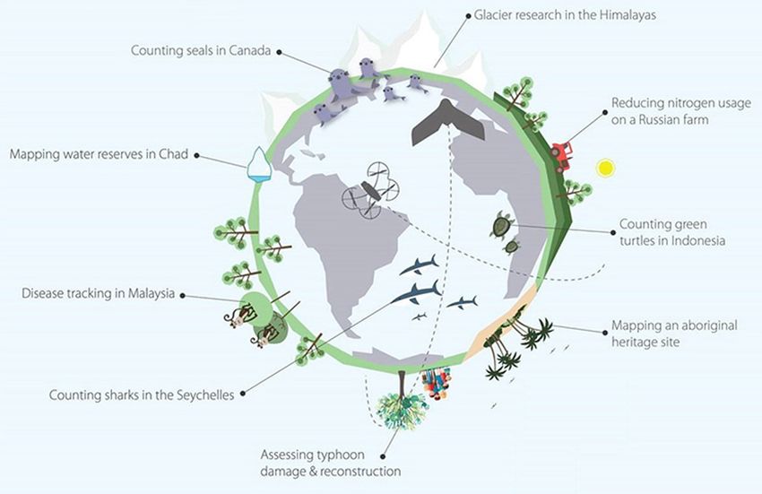
Drones: applications and compliance for surveyors

iv RICS insight                                       May 2019
rics.org/insights

Foreword

Drones, or to give the technology its correct moniker, unmanned aerial vehicles (UAVs)
or unmanned aerial systems (UASs), are a rapidly evolving and highly adaptable form of
disruptive technology. The technology has multiple potential applications within numerous
surveying-related sectors, which range from geospatial surveying and mapping to scanning,
building surveys, environmental monitoring and agriculture, to name just a few. This insight
paper is designed to address a complex sector and to underline the critical importance of
adhering to national and regional legislation and the associated regulations.
UAVs are easy to access but more challenging to use. These challenges range from adhering
to the relevant jurisdiction’s operating regulations, understanding the necessity for appropriate
levels of training (piloting) and assessments to, importantly, providing the survey output clients
expect from a professional surveyor.
Although UAVs can be used for a wide variety of survey-related applications, we also
wanted to give surveyors an insight into the importance of the sensors the drones carry,
and how development of these sensors will play a pivotal role in the future success of the
sector. Technological miniaturisation of laser scanning equipment, such as LiDAR, and the
resurgence of high accuracy photogrammetry (and its related software) have meant UAV
output and accuracy can now compete with the more established technology, such as
satellite imagery and manned aircraft. Yet it is important to understand not only the potential
applications of UAV use, but also its limitations.
UAVs have evolved beyond the ‘hype’ and are now starting to become operationally viable
on an expanding commercial basis. Of course, UAVs are not just for surveyor use and can
be used by numerous other professions and sectors, but we are part of a broad church and
believe that this insight paper provides an opportunity to understand and appreciate the
potential benefits of UAV use.
We are indebted to our industry colleagues for the peer-review process and commentary that
this insight paper has received, and hope you find it as interesting an area as we believe it is.
James Kavanagh
Global Land Standards Director

May 2019                                                                              RICS insight 1
Drones: applications and compliance for surveyors

 Glossary

  3D point cloud                       3D geometric information, mainly acquired through laser
                                       scanning and photographic surveying technologies. It is
                                       used for digital surface modelling (DSM), as-built building
                                       information modelling (BIM), digital elevation modelling
                                       (DEM) and digital terrain modelling (DTM).

  Agronomic characteristics            Relating to the science of soil and plant characteristics.

  CAP 722                              Unmanned Aircraft System Operations in UK Airspace –
                                       Guidance.

  CE marking                           Certification mark that indicates conformity with health,
                                       safety and environmental protection standards for
                                       products sold within the European Economic Area.

  Copernicus                           The EU’s Earth observation programme.

  Drone operator                       Person or organisation who manages the drone, but is not
                                       necessarily controlling the flight.

  Drone pilot                          Person who operates the drone’s flight by manual use of
                                       the controls or, if the drone is flown automatically, is able
                                       to monitor its course and intervene by adjusting the flight
                                       controls.

  Electronic conspicuity               Automatic identification of all airspace users, including
                                       drones.

  Geofencing                           Software feature using GPS to define geographical
                                       boundaries.

  Geospatial data                      Data that includes a direct or indirect reference to a
                                       location on Earth.

  Geotagged radiometric image          Image associated with a geographical location, taken
                                       with a thermal sensor that has temperatures of individual
                                       image pixels.

  Gimbal                               A rigid frame acting as a pivot and allowing full rotation on
                                       a single axis.

2 RICS insight                                                                              May 2019
rics.org/insights

 Inertial measurement unit       Electronic device used to provide position data. It
                                 measures and reports a body's specific force and
                                 angular rate using a combination of accelerometers and
                                 gyroscopes.

 Line of sight                   Aircraft must be able to be seen clearly by the person
                                 flying it at all times when the aircraft is airborne.

 Orthoimage mosaics              A group of orthoimages (geometrically corrected aerial
                                 imagery) stitched together to form a new composite
                                 image.

 Orthorectified imagery          Aerial photography, where the scale has been corrected
                                 geometrically to take into account any optical distortions
                                 from the sensor system.

 Payload                         The load, usually measured in terms of weight, that is
                                 carried by the drone, e.g. a camera.

 Photogrammetry                  The science of generating measurements from
                                 photographic images.

 Satellite                       Artificial object orbiting Earth, or any other planet, for the
                                 purpose of either communication or data collection.

 Small unmanned aircraft (SUA)   Any aircraft operating without a human pilot on board.

 Thermographer                   Individual qualified to monitor an object’s temperature
                                 variations through radiation detection, either with or
                                 without visible illumination.

 Unmanned aircraft system        Whole system that includes a human-operated control
 (UAS)                           base, UAV (see below) and a command and control system
                                 linking vehicle and controller.

 Unmanned aerial vehicle (UAV)   Aircraft with no human pilot on board. They can be flown
                                 remotely from the ground, or autonomously by way of a
                                 pre-programmed flight plan.

 Unmanned traffic management     Air traffic management system operating autonomously.
 (UTM) system

May 2019                                                                            RICS insight 3
Drones: applications and compliance for surveyors Acronyms and initialisms ANO Air Navigation Order BEIS Department for Business, Energy and Industrial Strategy BVLOS Beyond visual line of sight CAA Civil Aviation Authority (UK) CASA Civil Aviation Safety Agency DPA Data Protection Act 2018 EASA European Aviation Safety Agency EVLOS Extended visual line of sight FAA Federal Aviation Administration (USA) FINS Flight information and notification system GDPR General Data Protection Regulation GNSS Global navigation satellite system LiDAR Light detection and ranging scanner OGI Optical gas imaging OSC Operating Safety Case PfCO Permission for Commercial Operations (UK) SfM Structure from motion SUA Small unmanned aircraft TSC Transport Systems Catapult VTOL Vertical take-off and landing 4 RICS insight May 2019
rics.org/insights

1 Introduction

The development of disruptive technologies has changed the way we live and work
throughout history: the steam engine, the automobile, the personal computer, more recently
the smartphone – and now the drone.
The first military use of unmanned aircraft, or air drones, dates back to 1849 when Austrian
soldiers attacked the city of Venice with unmanned balloons filled with explosives1. The term
‘drone’ possibly originates from the 1935 wartime aircraft called the Queen Bee, or could
possibly be an acronym for dynamic remotely operated navigation equipment. Drones have
been widely used in the military since the 1980s, although the past ten years has seen the
use of drones for non-military purposes, with significant growth in commercial use over the
last five years.
The recent drone incidents that forced the repeated closure of Gatwick airport at the end of
2018, and separate incidents at Heathrow and Newark Airport in New Jersey in early 2019,
along with public concerns relating to privacy and security and terrorist use, has meant the
public perception of drones has hit a definite low point. Conversely, there are predictions for
considerable growth in value of the drone industry, and reports of significant benefits that
drones can bring to the economy and society.
Most of us are aware of the use of drones in the military, film and television production, and
surveying and mapping – and more recently tethered drones were used for broadcasting
and security at the 53rd US Super Bowl. For those in the surveying profession, drones have
become just ‘another tool in the toolbox’, but for most drone users the focus is on the sensor
that the drone can carry. Sensors are now capable of producing far higher resolution and
richer data than ever before. Sensor manufacturers have recognised the opportunities offered
by drone technology and are working on reducing the size, weight and power requirements of
their sensors to meet a suitable payload for drones.
Many industries have warmed to the potential that drones can bring. This is because these
smaller aircraft platforms, operating at lower altitudes than satellites and manned aircraft,
result in the democratisation of data and overcome the hurdles, such as cloud cover, faced by
these more traditional platforms.
Types of sensors include ultra-high definition (UHD) video, optical cameras (red, green and
blue (RGB)), thermal, LiDAR, optical gas imaging and multispectral and hyperspectral (see
sections 3.1–3.7). Many of these have been through the test stages and are now accepted
technologies. Impressive processing software, for example, structure from motion (SfM)
photogrammetry, adds an additional benefit to these technologies.
Despite fast-moving developments, drones are still in their infancy. As the technology develops
the regulatory system is playing ‘catch-up’ and governments are grappling to regulate the
practitioners, manufacturers and systems within the industry. There is also the ever-increasing
need for simplicity as the different standardisation bodies become involved to ensure the
technology is fit for purpose and will integrate seamlessly into daily life.

May 2019                                                                             RICS insight 5
Drones: applications and compliance for surveyors

 Businesses require an understanding of the industry and its capabilities as they develop
 their own drone strategies and assess the potential impact the technology will have on their
 profession. It is inevitable that drones will impact your profession in some way – the industry is
 thriving and drones are likely to be here to stay, regardless of current public perception.

 1.1      Types of drones
 The typical drone on the market today is battery powered with propellers for propulsive power.
 Flights are limited in range and time by battery life, payload, line of sight, regulatory constraints
 and radio signal to the controller.
 There are four main types of air drones:
 • fixed wing (like an aeroplane)
 • rotor (similar to a helicopter)
 • multi-rotor
 • hybrid.
 In UK law drones are split into the following categories according to their weight or mass (see
 CAP 722 for guidance on drone operations within UK airspace2):
 • Small unmanned aircraft (150kg: unmanned aircraft within this class will normally be
   subjected to the same level of regulatory approval as traditional manned aircraft. They will
   normally be certificated by the European Aviation Safety Agency (EASA), although there is
   also scope to approve UK-only operations via the same process used for light unmanned
   aircraft.
 This insight paper typically, although not always, relates to small unmanned aircraft (SUA),
 specifically air drones that are 20kg or less (including tethered drones, where the unmanned
 aircraft remains securely attached via a physical link to a person, the ground or an object at all
 times while it is flying). Most drones today have built-in safety features in the interests of public
 safety and national security, including:
 • a range of specifications and features, such as avoidance sensors, gimbals and
   microprocessors (previously only available on high-end and expensive drones but
   increasingly available on more affordable options)

6 RICS insight                                                                              May 2019
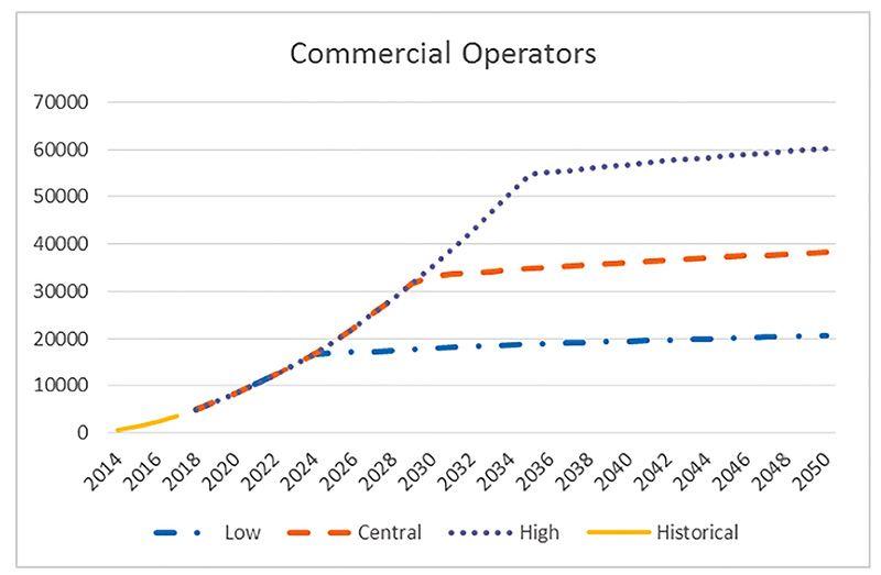
rics.org/insights

• multirotor and hybrid drones have vertical take-off and landing (VTOL) capabilities – in
  terms of safety a six- or eight-motor multirotor drone will usually keep flying when one, or
  even two, motors fail. A quadcopter (which has four motors) will fall to the ground in the
  event of a motor failing
• multirotor drones can hold their position in the air (assuming they have an on-board global
  positioning system (GPS) and/or obstacle avoidance by ground sensors), which makes
  them particularly useful and safe in confined areas, and in areas requiring controlled use,
  e.g. urban areas, infrastructure inspections.
1.2     Size of the drone industry
According to the CAA’s online list of approved commercial operators of SUAs (
Drones: applications and compliance for surveyors

 Taking cognisance of the potential offered by drones, commercial organisations are investing
 in research and development while collaborating with research institutes, to demonstrate new
 uses for drones. The number of drone-related patents has been increasing in line with this
 uptake. Similarly, the number of academic research papers published in recent years has
 seen a consistent increase over the last five years.
 Links between manufacturers, practitioners, regulators, and governments involved in the
 drone industry have become stronger and this will provide a solid foundation for the growth of
 a safe, secure and fully accountable industry.

 Figure 2: Beneficial drone applications around the world

8 RICS insight                                                                        May 2019
rics.org/insights

2 Opportunities and challenges

Like the drone industry, satellites (the more traditional remote sensing data collection
platform) have seen a significant increase in both number and range, such as the recently
launched Sentinel satellites developed specifically for Copernicus, the European Union’s Earth
observation programme. Despite these advances, there is still limited availability of high spatial
(50 hectares.

2.1     Opportunities
The deployment of drones as data collection platforms, to service a diverse range of civilian,
scientific and remote-sensing applications (see Figure 2), is an area of intensive research
and development. Compared to satellites and manned aircraft, they are more flexible and
adaptable, and can be flown freely (subject to suitable weather conditions).
Unlike satellites drones are not, typically, on a fixed orbit and do not have the significant
mobilisation requirements of manned aircraft. In addition, they have the capability for greater
temporal data and far richer spatial resolution, particularly when data is required for a small
area (see Figure 3). In terms of spatial coverage, satellites and manned aircraft will always have
the advantage, but drones offer remote sensing that bridges the gap between the ‘boots on
the ground’ and satellites or manned aircraft.

Figure 3: Drone imagery (centimetre resolution per pixel) versus satellite imagery
(metre resolution per pixel)
Drones are small, offer highly flexible use, are easy to handle and available at a comparatively
low cost. In emergency situations, e.g. search and rescue, drones offer additional benefits
in providing close to real-time information and a better understanding of the dynamics of the
environment. Also, the lower costs and reduced time-frames ultimately mean improvements
in site and asset management. Drone operators can also generally work around (or below) the
weather restrictions, such as clouds, that limit other remote-sensing platforms.

May 2019                                                                              RICS insight 9
Drones: applications and compliance for surveyors

  Considering all of these advantages it is no surprise that there is intensive research and
  development into the use of drones across a number of domains, such as energy, safety
  and security, construction, mining, quarrying, oil and gas, agriculture, insurance, real estate,
  industry, transportation and environmental monitoring. Some universities are leading the way
  in innovative uses of drones, e.g. Imperial College London’s water sampling drone and drones
  for 3D printing.

  2.2      Challenges
  With opportunities come challenges and there are several relating to the drone industry.
  Public concern in relation to privacy, security and safety issues is one of the main issues. It
  is hoped that these concerns will be mitigated by a regulatory framework for flying drones,
  manufacturing drones and data management and security. A result of introducing regulations
  may be over-regulation, which could inhibit the growth of the industry – so it will be important
  to strike the right balance from collaboration and communication between the various relevant
  parties.
  Other challenges include the energy consumption of the drone, which can become a limiting
  factor in terms of flight time and payload; in some cases a task may not be feasible by drone
  but developments in new battery technology should offer a solution to this issue.
  Geopolitical tensions may also have an impact on the future of drone technology as a number
  of recent incidents have resulted in restrictions being placed on technologies manufactured in
  different global regions.
  Cybersecurity is also an issue especially if there is involvement with critical infrastructure, such
  as nuclear power plants or military sites, or other sensitive projects and cloud-based data
  storage where processing options are employed.

10 RICS insight                                                                              May 2019
rics.org/insights
3 Sensors and drone innovation
A drone’s flying capability and its ability to reliably carry a heavy payload are key functions, as
the drone is only a toy if it is not capable of carrying a sensor or other payload, e.g. medical
supplies. Table 1 shows some examples of sensors currently available, and their uses.
Drone technology is relatively affordable in comparison to the more traditional remote-
sensing platforms and it enables data to be captured with a range of sensors across many
applications for a relatively small investment. Drones offer high versatility, adaptability and
flexibility compared with manned airborne systems or satellites, and have the potential to be
rapidly and repeatedly deployed to obtain high spatial and temporal resolution data. Although
the drone is the enabling technology, it is sensors that are the important technology with the
power to determine the future of the drone industry.
Type of sensor Current uses
Imagery
Optical cameras
Mapping
(still and video)
3D models
Optical gas imaging Gas leak detection
Vegetation monitoring
Multispectral
Crop health management
Thermal Solar farm inspections
Vegetation monitoring
Hyperspectral
Minerals mapping
Laser scanners/LiDAR 3D modelling
Table 1: Sensors and examples of their uses
3.1 Cinema/video
You may have noticed an increase in overhead film shots and distant vistas from above
ground in movies. These shots are thanks to drones with appropriate stabilisation that can
carry cameras of exceptional quality for producing cinema-grade footage. There are many
drones available that can carry these cameras: some as integrated units, others with a gimbal
capable of carrying the required payload.
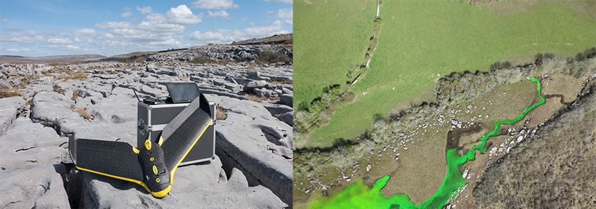
May 2019 RICS insight 11Drones: applications and compliance for surveyors 3.2 Optical cameras Drone-mounted cameras are currently being used to monitor physical assets and infrastructure, including building and bridge inspections for maintenance purposes, railways, roads, mining and oil and gas facilities. On construction sites, the use of drones has increased as the benefits of what drone data offers are realised – with the data potentially suitable for input into building information models (BIM). Drones with optical sensors can provide a useful snapshot in time to monitor construction works, and can also be beneficial for wind turbine and blade inspection. In addition, many estate agents (residential surveyors) will now include an overhead photograph, taken by drone, in the particulars of a property for sale. Figure 4: Fixed-wing drone used to survey a karst landscape Figure 5: Multirotor drones used to survey high limestone cliff faces for bat roosts Geomatics surveyors will likely be aware of the relatively new SfM photogrammetry software that enables imagery to be georeferenced and stitched together into one image. Using drone- collected data, surveyors can fly over sites of interest, with suitable overlap parameters, and produce high resolution 3D point cloud data and derived orthorectified imagery. In recent years, SfM photogrammetry packages such as Bundler, Pix4d, and Agisoft Metashape have made it easier to produce high-quality digital elevation models and orthoimage mosaics from imagery acquired with variable orientations and overlap, and from 12 RICS insight May 2019
rics.org/insights

cameras that have not been rigorously pre-calibrated. Even consumer-grade optical cameras
(RGB) can be used in the production of high-resolution orthomosaics and surface models
derived from SfM techniques.
The three advantages of drones and SfM are speed, cost and resolution. It is widely
anticipated that drones will start to take over from GPS, total station and laser scanners as
the main survey grade data collection method as they are far more efficient at capturing
geographic data, particularly over larger and more detailed sites. This will bring significant
financial benefit to those companies using drone technology to collect geographic data; for
example, fixed wing drones have been used to survey a karst landscape in tandem with a
hydrogeological assessment. Dye-tracer tests were performed to determine the direction
of ground-water flow and drone data was used to identify the location of natural discharge
points (springs) for the karst aquifer system (see Figure 4). Also, in Georgia, multirotor drones
have been used to survey high limestone cliff faces to find caves that may be suitable for bat
roosts, as part of a proposal to construct a hydro dam and flood the limestone gorge. The bat
survey formed part of the environmental impact assessment for the proposed development
(see Figure 5).
SfM photogrammetry software packages are bringing photogrammetric methods to a larger
user group and typically involve almost fully automated workflows. Although raw imagery
acquired from small drones typically has sub-decimetre ground resolution, this high spatial
resolution does not necessarily imply correspondingly-high spatial accuracies, unless rigorous
workflows are followed. The quality of the global navigation satellite system (GNSS) capability
of the drone has a significant influence on the data accuracy achievable. Relatively affordable
drones with both real-time kinematic and post processing kinematic GPS capability may
reduce or even negate the requirement for ground control points in some applications. Survey
data accuracy can also be affected by the on-board inertial measurement unit (IMU), data
collection parameters and site characteristics.
The TSA Client Guide To Small Unmanned Aircraft (SUA) Surveys states that ‘as a rule of
thumb the precision, (or relative accuracy) of the drone survey after processing, is known
to be within the order of 1–2 pixels in plan and 2–3 pixels in height’.5 Using this principle, if
the ground sampling distance of a survey is 40mm the accuracy could be assumed to be
approximately 40–80mm in plan and 80–120mm in height.
Geomatic surveyors will need to consider a number of parameters before producing
suitable mapping from a drone survey, such as flight planning, area to cover, required image
overlap (lateral and longitudinal), and the use and distribution of ground control, as these
considerations will have a significant influence on the quality of the end product.

3.3     Thermal
Thermal or heat detection sensors are easy to use, and the data images collected
straightforward to understand. However, depending on the end use, a qualified
thermographer may be required to interpret the results as they will understand the thermal
radiation spectrum.
There are two types of thermal data: radiometric and non-radiometric. Radiometric data
means that a specific temperature is provided for each pixel or point of data; non-radiometric
data shows more general temperature differences and changes in an area.

May 2019                                                                                 RICS insight 13
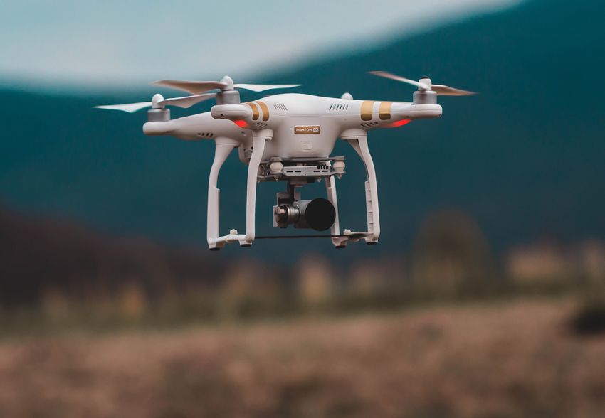
Drones: applications and compliance for surveyors

  Some examples of thermal sensor use include utility inspections (power lines, chimney stacks,
  water works, telecoms masts, substations), solar farm inspections, construction site and
  roofing inspections, fire-fighting, search and rescue, and land contamination monitoring (e.g.
  mining, landfills).
  Geotagged radiometric images can be processed in SfM photogrammetry software to
  produce an orthorectified stitched thermal image. Aerial differential infrared thermography can
  be carried out to improve a thermal assessment of an asset. This is carried out by performing
  two measurements of the same region at two different environment temperatures (e.g. sunrise
  and sunset) and comparing the results.

  3.4      LiDAR
  Airborne laser scanning is a technology used for topographical surveying and mapping, e.g.
  hydrological mapping, construction and forestry. This method employs a light detection and
  ranging (LiDAR) scanner and is based on time of flight measurements of emitted laser pulses
  from surfaces on or near ground, measuring the distance to the object from the sensor.
  The main output from a LiDAR survey is a 3D point cloud. The purpose of the survey, and
  the required density of the point cloud will determine the specification of the sensor. LiDAR
  surveys are capable of mapping extremely narrow objects, such as overhead electricity lines,
  subject to the resolution employed.

  3.5      Optical gas imaging
  Optical gas imaging (OGI) cameras can pinpoint gas leaks invisible to the naked eye. With an
  OGI camera it is easy to continuously scan installations in areas that are remote or difficult to
  access.
  OGI cameras are widely used in industrial settings, such as oil refineries, natural gas
  processing plants, offshore platforms, chemical/petrochemical complexes, and biogas and
  power generation plants.

  3.6      Multispectral
  The human eye is only sensitive to wavelengths between 400nm and 700nm, which is known
  as the visible RGB spectrum. Multispectral camera remote sensing imaging technology
  uses green, red, and near-infrared wavebands to capture both visible and invisible images.
  Multispectral remote sensing is widely used in agriculture and for environmental monitoring
  purposes, typically for assessing soil or vegetation health. Figure 6 shows examples of
  multispectral, thermal and RGB data images from a mine tailings facility. The data was used to
  assess the tailings dam for seepages and/or contamination issues.
  Viewing the health of soil and crops with the naked eye is very limited. Multispectral imaging
  allows for the extraction of additional information the human eye fails to capture and is a very
  effective tool for evaluating the agronomic characteristics of soil, plants and crops. Besides
  vegetation indices for evaluating green biomass, multispectral images can be formulated to
  other spectral indices targeting senescence evaluation, nutrient status, pigment degradation,
  photosynthetic efficiency, or water content.
  Multispectral data are typically processed using SfM photogrammetry software.

14 RICS insight                                                                            May 2019
rics.org/insights

Figure 6: Multispectral, thermal and RGB data from a mine tailings facility

3.7     Hyperspectral
The main difference between multispectral and hyperspectral sensors is the number (and
narrowness) of bands used. A hyperspectral image can have hundreds or thousands of
bands, offering better capability to see what the human eye cannot.
Hyperspectral sensors are being used in mineral mapping, land contamination monitoring,
agriculture, ecology, oil and gas, oceanography and atmospheric studies.

May 2019                                                                       RICS insight 15
Drones: applications and compliance for surveyors

  4 Potential uses of drones

  The commercial use of drones continues to gain momentum – aided by a decrease in costs
  and an increase in the reliability of the technology.
  As the software is developed to integrate with the drone hardware, uptake across individual
  operators and large organisations is set to increase; with software options for processing
  drone data including licensed, cloud-based and open source.
  The development of standardisations and the evolution of regulations in drone technology
  (e.g. flight planning and geofencing) will result in the use of drones becoming increasingly
  widespread, efficient and reliable. Advances in automated processes for flying and data
  collection will see the more risk-averse user adopt drone technologies in existing workflows.
  Advances in artificial intelligence and machine-based learning will see automated approaches
  to analysing gigabytes of imagery data, which will be particularly useful for infrastructure
  inspection.
  Drones and associated workflows will be packaged as a complete solution (some already are),
  and comply with standards in manufacturing, pilot competency, safety and regulation through
  to automated data capture, and approved methodologies for data collection and analysis.
  Ongoing developments in regulation will ensure safety, security and accountability.
  Eventually, drones will be used for everyday tasks such as fertilising fields, monitoring traffic
  in urban areas, delivering packages to remote rural regions, express deliveries in urban areas,
  and emergency medical deliveries, e.g. defibrillators, bloods. NHS Highland is currently
  working with Highlands and Islands Enterprise and the University of the Highlands and Islands
  on a project that could see drones pick up and deliver medical items across its regions.
  In some cities, where drones are faster for deliveries than current transport methods, this may
  offer an additional advantage of a reduction in carbon dioxide emissions.
  Research is currently being carried out into using drones for taking water samples from lakes
  and rivers, carrying passengers, taking air samples from volcanoes (see below), and using
  drones for 3D printing. Perhaps we will even see drones being used to clean the windows of
  the world’s tallest buildings in the not-too-distant future?

  4.1      Use of drones in urban environments
  Nesta, a global innovation foundation, has prepared a report from their Flying High
  Challenge.6 The project explored the current and future possibilities for the use of drones in
  urban environments through engagement with five UK areas (Bradford, London, Preston,
  Southampton and West Midlands), national level institutions and policy and technology
  experts. The project explored the following five socially beneficial uses of drones and the
  technical, social and economic aspects of each:
  • medical delivery in London
  • traffic incident response in the West Midlands
  • Southampton to Isle of Wight medical deliveries

16 RICS insight                                                                           May 2019
rics.org/insights

• construction and regeneration in Preston
• supporting the fire and rescue service in Bradford.
4.2     Environmental monitoring
Imaging spectroscopy, using spectral libraries, has been developed as a reliable technique
for quick mineralogical analysis of mine wastes, which saves both time and costs versus
conventional sample collection. Traditional data collection methods involved sensors mounted
on satellites (20–30m resolution) and manned aircraft (2–10m spatial: 10–20nm spectral
resolution). However, smaller and lighter hyperspectral sensors are now being mounted on
UAVs allowing hyperspectral data to be collected at a higher temporal and spatial resolution.
There are obvious benefits of using UAV-mounted hyperspectral sensors for monitoring
a range of environments, for example, to monitor mine sites and contaminated land.
There are also definite benefits in this technology for mine rehabilitation works as it
provides an invaluable tool for environmental evaluation and change analysis. In isolation,
however, hyperspectral data is not enough – but when used along with other monitoring
methodologies, and calibrated correctly, it provides very useful information for a variety of end
uses.

4.3     Humanitarian and sustainable development
Humanitarian aid and sustainable development involves dealing with many complex
challenges, including fast-changing environments, extreme weather events, climate change
effects, and high-risk environments. There are significant advantages to using drones to assist
humanitarian aid efforts, development and peacekeeping operations, for example, delivering
emergency supplies (e.g. food, medicine) to isolated areas that may be inaccessible by road;
gathering up-to-date geospatial data (e.g. for areas affected by earthquakes, landslides); and
search and rescue or damage assessment.
The United Nations Children’s Fund (UNICEF) and the World Food Programme (WFP) have
formed a working group to extend the use of drones for humanitarian work. Similarly, the
World Bank Group (one of the largest sources of funding and knowledge for developing
countries) is harnessing the potential of using drones to support development operations and
is currently relying on drone technology for post-disaster damage assessment, infrastructure
management, and risk assessment. The company has identified the potential for drone use to
assist in Internet connectivity in rural areas (through a perpetually airborne network of drones),
meteorology (using reusable airborne weather sensors), and firefighting.

4.4     Monitoring of volcanoes
The amount of gas emitted from a volcano during a specific time-period is directly related
to the volume of magma that sits in the subsurface reservoir. Measuring the rate at which a
volcano releases gas or degasses allows geoscientists to determine what is happening below
the surface. Changes in gases, such as sulphur dioxide and carbon dioxide, are important as
they can be indicative of activity occurring in the volcano’s magma reservoir and hydrothermal
system. Researchers use the ratio of these two gases to determine how close the magma is
to reaching the earth’s surface, and how imminent an eruption may be.
Emission rates can be measured either from the ground, from an aircraft or by space
observations (e.g. the Copernicus Atmosphere Monitoring Service). Safer measurement

May 2019                                                                              RICS insight 17
Drones: applications and compliance for surveyors

  techniques of high-altitude plumes of risky volcanoes are needed, however, and engineers
  and volcanologists from the University of Bristol and University of Cambridge have recently
  used drones to take measurements from inside volcanic clouds in Guatemala.

18 RICS insight                                                                         May 2019
rics.org/insights

5 Drone regulations

The aviation industry is renowned for its dedication to safety, to the extent that other high-risk
and safety-conscious industries, such as medicine and nuclear, are now using safety methods
developed by the aviation industry.
In the UK, the Civil Aviation Authority’s (CAA) stated primary aim is to enable the full and safe
integration of all drone operations into the total aviation system, and the regulations are being
developed to achieve this.
Currently the drone industry is regulated under the Air Navigation Order (ANO) 2016 and
the Air Navigation (Amendment) Order 2018. Some of the provisions in the Amendment
Order came into force on 30 July 2018 with more provisions due to come into force on 30
November 2019. All drones must be used in accordance with the rules set out in the ANO
and CAP 722.
The ANO regulates air navigation, so indoor use of drones or flights within buildings or areas
where the unmanned aircraft cannot escape into the open air are not subject to this air
legislation.
The UK regulators are in ‘catch up’ mode with the rapid evolution of the drone industry and
the government intends to bring forward a new draft Drones Bill in 2019. The government
ran a consultation in 2018 to receive feedback on proposals to develop policy and regulation
surrounding the use of drones and to set out the next steps needed to ensure safety, security
and accountability of the drone industry.

5.1     General aviation rules
Surveyors need to have a familiarity with the current drone regulatory environment and the
requirements of using drones or drone-collected data.
These requirements include general aviation rules that apply to everyone, regardless of
whether they are flying a drone or not, including:
• a person must not recklessly or negligently act in a manner likely to endanger an aircraft,
  or any person in an aircraft, and
• a person must not cause or permit an aircraft to endanger person or property.
These offences can lead to a five-year prison sentence, an unlimited fine or both.
Under the Aviation and Maritime Security Act 1990, intentional use of a device to commit
an act of violence at an international airport that causes or is likely to cause death, serious
personal injury and endanger safe operations could result in a penalty of life imprisonment.
Drone pilots that collect personal data must comply with the Data Protection Act 2018 (DPA),
unless a relevant exemption applies. The requirements of the DPA are overseen by the
Information Commissioner's Office (ICO) which can take enforcement action against people
who breach the DPA by requiring them to change practices, impose fines or by prosecution
for unlawfully obtaining or accessing personal data.

May 2019                                                                              RICS insight 19
Drones: applications and compliance for surveyors

  The CAA has been running a Dronesafe campaign and produced The Drone Code to help to
  raise awareness of these rules and regulations among the general public.7
  Drone-specific aviation rules, relevant to all drone pilots (hobbyists and commercial users)
  include:
  • small drone pilots must maintain direct, unaided visual contact with their drone
  • the drone may only be flown if the remote pilot is satisfied that the flight can be safely
    made
  • during take-off and landing, a remote pilot must not fly the SUA within 30m of another
    person
  • the small drone pilot must not allow any article or animal to be dropped from the drone as
    to endanger persons or property
  • all drones are restricted from flying above 400ft across the UK and within 5km (since
    March 2019) around protected aerodromes when air traffic control is operating.8 (Note that
    the aviation industry refers to height in feet and distance in metres.)
  If the drone is equipped with a camera:
  • it must not be flown within 50m of persons or buildings
  • it must also not be flown within 150m of densely populated areas.
  From 30th November 2019, it will be a legal requirement, before flying a drone of 250g–20kg
  in mass, for all drone operators to register, and for drone pilots to complete, an online pilot
  competency test.

  5.1.1    General Data Protection Regulation (GDPR)
  On 25 May 2018 the GDPR came into force. If a person can be identified or is identifiable by
  drone-collected information, then it is considered personal data. All drone operators need to
  be aware of their responsibilities under the GDPR.
  Recommended good practice in relation to data protection includes:
  • preparing a privacy code of conduct
  • a pre-flight checklist
  • carrying out a privacy impact assessment.
  5.2      Commercial regulations
  Commercial users of drones can operate drones outside of general aviation rules – but only
  once CAA permission is granted to do so on the basis of meeting strict safety conditions. You
  must have a Permission for Commercial Operations (PfCO) issued by the CAA before you
  conduct any commercial drone operations.
  If you wish to conduct a commercial operation (see definition) with your aircraft or if you wish
  to fly your aircraft outside the limits specified above you will need permission from the CAA.
  An exemption from the CAA is required if you wish to seek release from any other requirement
  within ANO 2016. Permissions and/or exemptions are valid for up to 12 months and are
  subject to an annual renewal.

20 RICS insight                                                                            May 2019
rics.org/insights
The term ‘commercial operations’ allows a broad variety of flight applications, which are
mostly based around aerial photography or the operation of sensors and other data-gathering
devices.
Commercial operations are defined within the ANO as:
‘any flight by a small unmanned aircraft except a flight for public transport, or any
operation of any other aircraft except an operation for public transport;
a which is available to the public; or
b which, when not made available to the public,
i in the case of a flight by a small unmanned aircraft, is performed under a
contract between the SUA operator and a customer, where the latter has no
control over the remote pilot; or
ii in any other case, is performed under a contract between an operator and a
customer, where the latter has no control over the operator,
in return for remuneration or other valuable consideration.’
The key elements in determining commercial operations are ‘… any flight by a small
unmanned aircraft … in return for remuneration or other valuable consideration’. The term
‘available to the public’ should be interpreted as being a service or commodity that any
member of the public can make use of, or actively choose to use (because it has been
advertised or offered to someone).
5.2.1 Permissions for commercial work involving small drones
To operate a drone commercially, the key requirement is the CAA’s Permission for Commercial
Operations (PfCO). There are two types of permission available: a standard permission and a
non-standard permission.
The standard permission: this enables a person to conduct commercial operations with
a SUA (drone) and also permits operations within a congested area. Potential operators are
required to provide evidence of pilot competence (demonstrate a sufficient understanding
of aviation theory in airmanship, airspace, aviation law and good flying practice), pass a
practical flight assessment (flight test) and prepare an operations manual, which details
basic procedures for how the flights will be conducted. The CAA does not organise or run
assessment courses – commercial organisations, known as National Qualified Entities (NQEs)
organise this assessment on their behalf.
A non-standard permission: this covers all other types of flight and addresses operations
that contain a greater element of operating risk, e.g. extended visual line of sight (EVLOS) and
beyond visual line of sight (BVLOS), flights within 150m of organised open-air assemblies and
flights within 50m of uninvolved people/properties.
May 2019 RICS insight 21Drones: applications and compliance for surveyors In addition to the requirements for a standard permission, applicants are also required to prepare and submit an Operating Safety Case (OSC) to demonstrate that the intended operation is appropriately safe to the CAA. Tethered UAS are subject to the same basic operating regulations as all other unmanned aircraft and, where necessary, are subject to the same approvals process. However, the fact that the operation is tethered can be used as a significant mitigation factor when applying for an operating approval, thus greatly simplifying the overall process. 5.2.2 Other rules and regulations CAA permissions and exemptions only authorise the commercial use of a drone from a safety perspective. Drone practitioners will also need to abide by any other rules and regulations imposed by other bodies and organisations. These may include the emergency services, road maintenance organisations and local authorities. Before beginning a job in a particular location, a permission holder should always check with all relevant bodies to establish if any other restrictions apply. Operators should also be sure they understand the rules around trespass and nuisance. Details are available in guidance document CAP 722,2 including the requirements for remote pilot competence. 5.3 Jurisdiction-specific legislation Australia Australia have taken a slightly less onerous route than other countries to regularising commercial drone operations. If the drone weighs less than 2kg it can be operated in the ‘excluded’ category. This requires notifying the Civil Aviation Safety Agency (CASA) before you fly and operating within certain parameters, e.g. below 400ft, during daytime only, and within visual line of sight. Operations beyond these limits, or if your drone weighs more than 2kg, require a licence or for the operator to be certified to fly. This requires training and preparation of an operations manual and an interview with CASA. Singapore For drone operations that are non-recreational or non-research in nature then, regardless of the weight of the drone or the location of operations, an Operator Permit and Class 1 Activity Permit will be required. An assessment is carried out to ensure the operator, equipment and personnel flying the drone are fit and capable of conducting operations safely. A physical flight demonstration may also be required. UK The UK government’s Pathfinder Programme is part of a wider programme of work across the UK’s public and private sectors, aimed at enabling integration of drones into UK airspace. The programme falls under the governance of the Department for Transport, the Department for Business, Energy and Industrial Strategy (BEIS), the CAA and the Transport Systems Catapult (TSC). The aim is to rapidly drive progress in drone technology and regulation over the next ten years, enabling both industry and the public sector to fully exploit the drone market in areas such as geo-mapping, infrastructure inspections, surveying and logistics to both commercial and public-sector industries. 22 RICS insight May 2019
rics.org/insights

USA
There are two federal laws that regulate drone technology, along with state and local laws:
Section 336 of the Federal Aviation Administration (FAA) Modernization and Reform Act of
2012 and Part 107 of the FAA’s final rule for Operation and Certification of Small Unmanned
Aircraft Systems.
Section 336 relates to recreational use of drones (weighing over 55lbs). For commercial users
of drones Part 107 is relevant. Prior to implementation of Part 107 in 2016, commercial drone
users required a full commercial pilots licence to operate. Restrictions to drone flights under
Part 107 are similar to the UK and require operations to be carried out within line of sight,
below the 400ft flight height ceiling and only during daylight hours. Passing a knowledge test
is a requirement under Part 107.

5.4     Future rules and regulations
There is considerable regulatory activity among legislators, not just in the UK, but also in
Europe. These will address not just how drones are flown, but will also regulate product
standards, electronic conspicuity (which will allow the automatic identification of all airspace
users including drones) and geofencing (where a drone can be automatically prevented from
flying within protected areas through in-built software).
The UK government is currently working with drone manufacturers to introduce these new
technologies along with continuing to develop policy relating to a flight information and
notification system (FINS) as part of future unmanned traffic management (UTM) and airspace
modernisation programmes to ensure that all aircraft use airspace safely and securely and in
accordance with the rules. The government has decided not to mandate the use of a FINS
at this time, but will nevertheless continue to develop the policy as part of wider aviation
strategies, including a UTM system. This will be achieved by promoting the use of current
drone information applications and developing best practice guidelines to encourage their use
and improve consistency of data.
There has been debate about whether the final Drones Bill will include police powers relating
to drones and fixed penalty notices, a minimum age limit for the drone operator – who is not
necessarily the drone pilot (see Glossary) – and no age limit for the drone pilot.
The government is also expediting detailed policy work to develop an appropriate legal
framework that will allow for the testing and use of counter-drone technology that detects and/
or 'affects' drones in the UK and technology that could be used to protect sensitive national
infrastructure from possible malicious drone incursions in the future.
There have also been some developments at European level. In accordance with the new
basic regulation (EU 2018/1139), for which a political agreement between the European
Council, the European Commission and the European Parliament was reached on 22
December 2017, the competence of the EU has been extended to cover the regulation of
all civil unmanned aircraft systems (drones), regardless of their maximum take-off masses.
The proposed regulations will provide flexibility to member states, mainly by allowing them to
create zones within their territories where the use of air drones would be prohibited, limited
or, in some cases, facilitated. Pursuant to the new basic regulation (EU 2018/1139), market
product legislation (CE marking) ensures compliance with the technical requirements for
mass-produced drones operated in the open category.

May 2019                                                                              RICS insight 23
Drones: applications and compliance for surveyors

  The open category is one of three main categories being proposed by the EU in terms of
  operating a UAS in Europe:
  • open category does not require a prior authorisation by the competent authority or a
    declaration by the UAS operator, despite the risks involved
  • specific category requires an authorisation by the competent authority before the
    operation takes place, taking into account the mitigation measures identified in an
    operational risk assessment, except for certain standard scenarios where a declaration by
    the operator is sufficient or when the operator holds a light UAS operator certificate (LUC)
    with the appropriate privileges, and
  • certified category requires the certification of the UAS, a licensed remote pilot and an
    operator approved by the competent authority, in order to ensure an appropriate level of
    safety.
  As the industry evolves and technology and standards improve there may be a relaxation to
  the current drone flight limitations (i.e. 500m distance and 400ft flight height from the drone
  operator), as these are significant constraints to drone usage – and offer an advantage to
  other data collection methods (manned aircraft).
  With the development of standards in drone technology (e.g. flight planning, geo fencing,
  collision avoidance systems) along with the evolution of the regulations, drone use will
  continue to become more widespread and efficient. We may even see changes to airspace
  to allow drone usage in certain areas, or the provision of drone corridors. There are ongoing
  tests being carried out into BVLOS, remote identification and obstacle avoidance technologies
  that will ensure automated drones can operate safely.

  5.5      Standards
  As new technology develops, new standards are required to help regulate the drone industry.
  There are currently a number of standards in development.
  • The British Standards Institute (BSi) is working on standards for the ‘qualification and
    approval of UAS operatives’ and the ‘registration and identification’ of UAS or drones.
  • In Europe, standards are being developed for product requirements and verification,
    remote identification, geo-awareness and lighting requirements.
  • The International Organization for Standardization (ISO) have several active work
    programmes including terminology, categorisation and classifications, product
    manufacturing and maintenance, operations and procedures, and unmanned traffic
    management.

24 RICS insight                                                                           May 2019
rics.org/insights
6 Using drones in your business
1 If you plan to use a drone for a relatively simple purpose using a tried and tested drone
and data collection methodology, then it is relatively straightforward and affordable to get
up and flying (approximately £1,500–£2,000).
2 Before you choose your drone:
a find out what maintenance will be necessary
b ascertain how many motors you require and how long they will last
c check the battery shelf-life
d find out the cost of replacing batteries
e check the drone’s safety features, and whether it has GPS, a return-to-home
function and if geofencing is provided
f check what wind speed the drone can fly in
g ensure there is a warranty.
3 If you are using a drone for commercial use in the UK (see section 5.2) you will need to
complete the required ground school training and tests, and obtain a PfCO from the
CAA.
4 If you want to achieve more advanced results, such as produce orthorectified imagery
and 3D data, thermal or multispectral data, you may need to gain a further qualification or
training (e.g. geomatics, thermography) and purchase additional processing software.
5 You may also start producing large datasets that may require additional digital storage
hardware or if using cloud-based software or storage, you will need access to a high-
speed internet connection.
6 If you are going to buy your own drone and obtain your PfCO from the CAA then make
sure you maintain a certain level of pilot competency by flying regularly (at least 2 hours
per quarter). You will need to ensure you have the commercial business pipeline to
maintain this.
7 If you will be flying the drone mostly in rural areas, a standard CAA PfCO permission will
be sufficient, but if you are proposing to fly in urban areas you may have to prepare an
OSC and comply with a more stringent regulatory route.
8 Ascertain how many employees will be flying the drone. Depending on your business it
may make sense to have a number of people trained in operating the drone or to train
just one person if you are not using the drone regularly.
9 Check hidden costs. These generally relate to the regulatory requirements, insurance
costs, additional computer hardware for data storage and processing, along with
ongoing maintenance costs and time inputs.
May 2019 RICS insight 25You can also read