Dryden Regional Airport Strategic Plan 2021 - City of Dryden The Loomex Group 2021
←
→
Page content transcription
If your browser does not render page correctly, please read the page content below

City of Dryden
Dryden Regional
Airport Strategic
Plan 2021
© The Loomex Group 2021

Dryden Regional Airport Strategic Plan

Table of Contents
      Executive Summary ...............................................................................................1
      Dryden Regional Airport Background ..................................................................4
      Stakeholder Consultation ......................................................................................6
      Stakeholder Session Responses..............................................................................7
      Local Government (Internal) .....................................................................................7
      Local Government (External)....................................................................................8
      Emergency Service Providers ..................................................................................8
      Businesses ...............................................................................................................9
      Aviation.....................................................................................................................9
      Community Survey Results ................................................................................. 11
      Strengths, Weaknesses, Opportunities, Threats (SWOT) Analysis ................. 13
      Airside Infrastructure Development ................................................................... 15
      Runway .................................................................................................................. 15
      Critical Design Aircraft ............................................................................................ 15
      Taxiways ................................................................................................................ 18
      Aprons .................................................................................................................... 18
      Wind Direction Indicators........................................................................................ 19
      Fuel and De-icing Services..................................................................................... 19
      Runway Lighting ..................................................................................................... 19
      Precision Approach Path Indicator ......................................................................... 20
      Airfield Guidance Signs .......................................................................................... 20
      Airfield Lighting Controls......................................................................................... 20
      Approach Procedures ............................................................................................. 21
      Air-to-Ground Communications .............................................................................. 21
      Runway Approach Surface ..................................................................................... 21
      Airside Security ...................................................................................................... 22
      Roadways and Vehicle Parking .............................................................................. 22
      Storm Drainage ...................................................................................................... 22
      Sanitary Sewage .................................................................................................... 23
      Groundwater Supply System .................................................................................. 23
      Pumphouse and Water Reservoir .......................................................................... 23
      Electrical Supply ..................................................................................................... 24
      Natural Gas Supply ................................................................................................ 24
      Airport Ownership and Governance ................................................................... 25
      Current Governance Model .................................................................................... 25
      Economic Review ................................................................................................. 27
      Regional Profile and Catchment Area .................................................................... 27

                                                                                                                           Page i
Dryden Regional Airport Strategic Plan

Income – Individual vs. Household ......................................................................... 29
Population by Municipality ...................................................................................... 31
Employment ........................................................................................................... 32
Main Business Sectors ........................................................................................... 33
Education Level ...................................................................................................... 37
Economic Impact Study ....................................................................................... 39
Objectives and Definitions ...................................................................................... 39
Methodology ........................................................................................................... 39
Results ................................................................................................................... 40
Past and Future Investments.................................................................................. 41
Economic Impacts Generated by External Passengers ......................................... 44
Economic Impacts Generated by External Passengers ......................................... 45
Total Economic Impacts ......................................................................................... 46
Foreign Investment Review ................................................................................. 47
Market Overview – Canada's Aerospace Industry .................................................. 47
Economic Impact .................................................................................................... 47
Ecosystem .............................................................................................................. 47
Global Value Chain ................................................................................................ 48
Innovation and Skills .............................................................................................. 48
Canada's Key Strengths in Aerospace and Aviation .............................................. 49
Ontario Aerospace Sector ...................................................................................... 49
Investment Readiness ............................................................................................ 50
Regional Foreign Direct Investment Attraction Strategies ...................................... 52
Recommendations ................................................................................................. 53
Passenger Activity Forecasts ............................................................................. 55
Passenger Activity Forecasts based on Community Survey Results ..................... 55
Effects of COVID-19 Pandemic on the Industry ..................................................... 57
Airport Business Plan .......................................................................................... 58
Airport Strategic Priorities ....................................................................................... 58
Strategic Priority #1 Financially Sustainable Airport System .................................. 59
Strategic Priority #2 Engaging with Scheduled Service Providers .......................... 62
Strategic Priority #3 Partnership(s) with Northern Communities............................. 62
Strategic Priority #4 Non-Aeronautical Land Development .................................... 62
Strategic Priority #5 Hangar and Facility Development and Activity Growth........... 62
Strategic Priority #6 Airport Branding and Marketing.............................................. 63
Strategic Priority #7 Transportation/Evacuation Hubs ............................................ 64
Strategic Priority #8 Securing Potential Government Grants and Subsidies .......... 65
Strategic Priority #9 Reviewing Fee Structure for Provincial Airport Use ............... 66
Strategic Priority #10 Review Airport Operations including Staffing and Hours of
Operation................................................................................................................ 67

                                                                                                                    Page ii
Dryden Regional Airport Strategic Plan

       Proposed Site Plan ............................................................................................... 68
       References ............................................................................................................ 70

List of TablesTable 1: Session Participants by Group                                                                          6
Table 2: Airport apron numbers, details, and condition details.                                                              18
Table 3: Breakdown of De-icing Utilization from 2016 to 2019                                                                 19
Table 4: Summary of the Direct, Indirect and Induced Economic Impacts                                                        40
Table 5: Presentation of Past Projects                                                                                       42
Table 6: Direct, Indirect and Induced Economic Impacts of Past Projects                                                      43
Table 7: Presentation of Future Projects                                                                                     43
Table 8: Direct, Indirect and Induced Economic Impacts of Future Projects                                                    44
Table 9: Assumptions and Calculation of the Economic Impacts Generated by External
           Passengers                                                                                                        45
Table 10: Summary of the Economic Impacts by Category                                                                        46
Table 11: Summary of the Non-Recurrent Impacts (Capital Investment Projects -
           Immobilizations)                                                                                                  46
Table 12: Corporate Survey Results – Site Selection Factors 2018 - 2019                                                      50
Table 13: Airport Expense Summary                                                                                            59
Table 14: Initiatives for Cost Reduction and Revenue Generations                                                             60
Table 15: Areas for Consideration for Financial Sustainability and Profitability                                             60
Table 16: Financial Forecast                                                                                                 61
Table 17: Considerations for Selecting a Transportation Hub                                                                  64

List of Figures
Figure 1: Airport Movements in 2018 and 2019                                                                                  1
Figure 2: Image of Survey on Smartphone Device                                                                               11
Figure 3: 74% of respondents have flown from the Airport.                                                                    12
Figure 4: 74% of respondents believe the Airport contributes to the economy                                                  12
Figure 5: Pie Chart of Reasons Other Transportation Is Chosen                                                                12
Figure 6: SWOT Graphic                                                                                                       13
Figure 7: Bombardier Aerospace Dash 8 – Q400 Dimensions (Boeing, 2020)                                                       16
Figure 8: Boeing 737 - 800 Dimensions from the Manufacturers Website (Boeing, 2020)                                          17
Figure 9: Diagram of ARCAL System (Hirschman, 2017)                                                                          20
Figure 10: Current Organizational Structure                                                                                  25
Figure 11: 100-kilometre radius around Dryden Regional Airport                                                               28
Figure 12: 60-Minute Driving Radius from Dryden Regional Airport                                                             29
Figure 13: Average Individual vs Households After-tax Income 2015                                                            30
Figure 14: Total Private Dwellings by Region (2016)                                                                          30
Figure 15: Population by Municipality (2011-2016)                                                                            31
Figure 16: Percent Change in Population by Municipality (2011- 2016)                                                         31

                                                                                                                       Page iii
Dryden Regional Airport Strategic Plan

Figure 17: Labour Force Participation Rates by Region                                  32
Figure 18: Percent Self-Employed by Region                                             32
Figure 19: Number of Businesses by Industry by Jurisdiction (2019)                     33
Figure 20: 4-Region Total Number of Businesses by Industry (2019)                      34
Figure 21: Labour Force by NAICS Code (2016)                                           35
Figure 22: 4-Region Total Labour Force by Industry (2019)                              36
Figure 23: Highest Certificate, Diploma or Degree by Municipality (#)                  37
Figure 24: Highest Certificate, Diploma or Degree by Municipality (% of Population)    38
Figure 25: Survey Respondents Frequency of Travel to Thunder Bay and Winnipeg          55
Figure 26: Likelihood Respondents would use the Airport for Travel to Thunder Bay or
          Winnipeg                                                                     56
Figure 27: Respondents Likelihood of Airport use if provided better options.           56
Figure 28: Total Aircraft Movements 2019                                               66
Figure 29: Proposed Site Plan                                                          69

Appendices
Appendix A: Community Survey
Appendix B: Key Performance Indicators Linked with Strategic Priorities

                                                                                  Page iv
Dryden Regional Airport Strategic Plan

         Executive Summary
The Loomex Group is the service provider managing the Dryden Regional Airport (Airport).
As part of the value-added service, the Airport's Strategic Plan was developed for the City
of Dryden (City). This plan aims to identify the Airport's socioeconomic impact, assess the
existing infrastructure and facilities, and provide recommendations for viable growth and
development opportunities to improve the Airport's influence as an economic driver for the
City.
The Loomex Group launched a comprehensive business review of the current Airport
operations to determine future strategic plans. The review included:
•    Collecting and reviewing relevant background information
•    Stakeholder consultations and a public survey
•    Regional economic review and economic impact assessment
•    Infrastructure and commercial inventory review
•    Review of current and potential governance options
•    Foreign investment review
•    Opportunities, value-adds, and strategic positioning
•    Passenger activity forecasts and growth projections
•    Exploring future development opportunities

Stakeholder consultations formed part of the preparation of the economic impact and
infrastructure review. The Loomex Group's consultation process included group and
individual meetings, held virtually and by telephone, with local and regional governments,
elected officials, economic development representatives, businesses and groups in the
community, and the aviation community. The stakeholder meetings' consensus revealed a
renewed desire to fully utilize and leverage the Airport's potential as an alternate
transportation mode and a vital component for regional economic development.

Engagement also included an online
survey to obtain valuable information
from community residents.                            2018                    2019
Approximately 75% of respondents
believe that the Airport supports the
local economy.                                    10,853                    9,560
                                                   Itinerant                Itinerant
                                                  Movements                Movements

                                                   1,213                    1,404
                                                Local Movements          Local Movements

    Figure 1: Airport Movements in                12,066                   10,964
                                                                         Total Movements
    2018 and 2019                               Total Movements

                                                                                        Page 1
Dryden Regional Airport Strategic Plan

The Airport handles approximately 10,000 to
12,000 aircraft movements annually and supports          The Airport's economic
various activities: from aerial firefighting, general
aviation, corporate charters, scheduled passenger
                                                         impact is estimated to
service, search and rescue operations, and               be $22.9M per year.
medevac flights. The Airport's economic impact is
estimated to be $22.9 million per year, with 347
full-time equivalents (FTE's) where 228 of the
FTE’s are directly attributable to airport tenants.

This report summarizes the information analyzed from the review process, evaluates the
Airport facilities against industry norms, and provides recommendations on development
opportunities to contribute to both the Airport and the City's economic stability. The
recommendations accumulated to form the ten strategic priorities that will guide the future
of the Airport.

                                                                                      Page 2
Dryden Regional Airport Strategic Plan

Strategic Plan Goal
The strategic plan's goal is to establish the DRA as a sustainable operation to become a
catalyst for economic development in the Kenora District. Ten identified strategic priorities
resulting from the analysis, broken down by short-, medium-, and long-term timelines, bring
about the five-year strategic plan's success. Appendix B outlines the Key Performance
Indicators (KPI) linked with strategic priorities.

Strategic Priorities
S: Short-Term (2021-2022) M: Medium-Term (2022-2023) L: Long-Term (2024-2025)

  Strategic Priorities                                                             Term

 1.     Financially Sustainable Airport System*                                      M

 2.     Engaging with Scheduled Service Providers                                    S

 3.     Partnership(s) with Northern Communities                                     S

 4.     Non-Aeronautical Land Development                                            M

 5.     Hangar and Facility Development and Activity Growth                          M

 6.     Airport Branding and Marketing                                               S

 7.     Transportation/Evacuation Hubs                                               M

 8.     Securing Potential Government Grants and Subsidies                           S

 9.     Reviewing Fee Structure for Provincial Airport Use                           S

 10.    Review Airport Operations including Staffing & Hours of Operation            S

Note: *could be affected by COVID-19 Pandemic

                                                                                      Page 3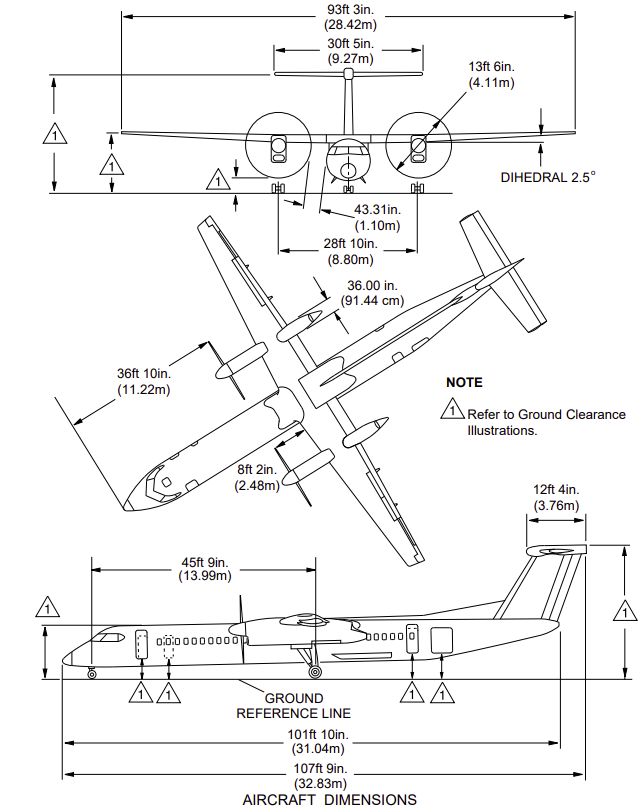
Dryden Regional Airport Strategic Plan

       Dryden Regional Airport Background
The City of Dryden is in the Kenora District of Northwestern Ontario at Wabigoon and
Thunder Lakes. The City has a population of 7,749, with 64% of the population falling within
the age of 15 to 64 categories (Statistics Canada, 2017). The Airport is approximately 6 km
northeast of the City. It occupies 815 acres, with a reference point at 412 meters (1,353 ft)
above sea level and provides an environment for excellent flying conditions. There are four
full-time municipal employees to support the operations, with one seasonal employee
during the winter months.

Development of the Airport commenced in 1969 when the City purchased 614 acres of land
utilizing financial assistance from the Federal Government through the Ministry of
Transport, now referred to as Transport Canada. Initially, the Ministry of Transport
constructed a gravel 3,600-foot runway, short connecting taxiway, and small apron. The
runway was to measure 3,600 by 100 feet; however, partway into construction, it was
revised to be 5,000 feet long by 100 feet wide in addition to a 2,000 by 75-foot crosswind
runway. The City and the Province of Ontario jointly financed the extension cost. A small
terminal was constructed and later expanded in 1973 and 1974, which increased the
terminal building's footprint to 3,312 square feet.

In 1970, the Ministry of Transport decided to pave the longer runway due to rutting on the
gravel surface. The Ontario Ministry of Natural Resources (MNR), now referred to as the
Ministry of Natural Resources and Forestry (MNRF), received approval to construct a water
bomber base at the Dryden Airport. By the end of 1970, the Airport consisted of a paved
runway 11-29, a taxiway and main terminal apron, and an MNR taxiway and apron south of
the end of runway 29. In 1971, Transair requested permission to operate Boeing 737
aircraft services into Dryden, and as a result, the runway width was expanded to 150 feet in
width to accommodate the size of the aircraft.

From the 1960s through to the 1980s, the Canadian Air Transportation Administration
(CATA), a Transport Canada division, managed and operated Canadian airports.
Investments in runways, terminals, and other buildings came from the Treasury Board
capital fund. Revenues derived from landing fees, terminal charges and ticket tax went to
the Consolidated Revenue Fund. There was no requirement for airports to be self-financed
or to break even. Airport capacity decisions were made at the national level and did not
necessarily reflect an individual airport's role and importance in its region. The first federal
policy that considered reforming airports' management and operation was issued in 1987
and was called A Future Framework for Airports in Canada (Library of Parliament, 2017).

                                                                                         Page 4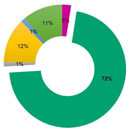
Dryden Regional Airport Strategic Plan

In 1992, Transport Canada transferred major Canadian airports to local authorities to
operate in a more "commercial and cost-efficient manner." In 1994, a National Airports
Policy (NAP) was announced, which called for Canada's 26 largest airports'
commercialization; furthermore, "the same policy also established Nav Canada as the not-
for-profit, non-share Capital Corporation that operates Canada's air navigation system…at
the same time the government divested itself of the vast majority of smaller, federally-
owned airports, in most cases selling them to provincial, territorial, or local authorities for a
nominal fee, and providing lump-sum funding for near-term safety needs” (CAPA Centre for
Aviation, 2016).

NAP classifies airports in Canada as either:

•   Part of the National Airports System, including facilities in national, provincial and
    territorial capitals, and airports that serve over 200,000 passengers each year;
•   Local and regional airports that serve less than 200,000 passengers each year; or
•   Small, remote, and arctic airports (Transport Canada, 2004).

On January 31, 1996, the Federal Government transferred ownership of the Dryden
Regional Airport to the City. Since then, the City has retained sole ownership and
operations.

                                                                                          Page 5
Dryden Regional Airport Strategic Plan
Stakeholder Consultation
The stakeholder consultation sessions took place between October 5 and November 18,
2020. The Loomex Group identified a list of key stakeholders to participate in the sessions
to explore and to gain feedback on the Airport's economic impact on the region. Organized
by sector and/or related services, participants received email invitations for the virtual
meetings instead of traditional in-person interviews due to the COVID-19 pandemic
restrictions. The groupings included the following:
• Local Government Representatives (City, First Nation Communities)
• City of Dryden Economic Development
• Emergency Services
• Aviation Businesses
• Community Organizations
• School Boards
• Business Community
• Airline Representatives
The Loomex Group team recognizes the importance of open and transparent engagement
between the Airport and key internal and external stakeholders. During the sessions, the
team provided an update on the project and listened to participants' feedback and
suggestions. Furthermore, probing questions were asked to gain perceptions and realities
from participants about the Airport, including community members' current use and
leverage with economic development and tourism agencies. The tables below highlight the
participants in the stakeholder sessions and do not include those invited to attend.
Table 1: Session Participants by Group
Group Attendees
City Council
CAO and Senior Management
Economic Development Manager
Ontario Justice System
Local Government
Township of Ear Falls
Township of Ignace
Emergency Services Dryden Fire Services
Northwest EMS
Dryden Regional Health Centre
Dryden Police Service
Ontario Provincial Police
Page 6Dryden Regional Airport Strategic Plan
Group Attendees
Aviation Community North Star Air
Northern Youth Programs
Hydro One
Ministry of Natural Resources and Forestry
Businesses Hydro One
Treasury Metals
Enbridge
TBaytel
Ontario's Sunset Country Travel Association
Government of Ontario
Community Groups and Keewatin-Patricia District School Board
School Boards Conseil scolaire de district catholique des Aurores boréales
Kenora District Services Board
Note: The table only notes participants who responded to the invitation and not the actual
invitees' list.
Stakeholder Session Responses
The following highlights the participants' responses from the stakeholder engagement
sessions listed according to their grouping.
Local Government (Internal)
The internal stakeholder consultations involved the Mayor and the CAO of the City. The
Airport was determined to be an essential economic driver for the region, as it supports
multiple businesses, including the MNRF Fire Management Centre, air ambulances,
scheduled service, and general aviation. The group also discussed that the Airport could
play a significant role in connecting with Northern Communities and discussed current
scheduled service status.
The Airport could also be a "hub" for tourism operators in the region, supporting tourism
activities in the area. Many sports teams visit the City for tournaments (hockey, broomball,
etc.), and some of these sports teams arrive by scheduled flight service or charter service
to the Airport.
Page 7Dryden Regional Airport Strategic Plan
Other items discussed included:
• Making the Airport self-sustainable
• Soliciting Provincial and Federal Government for funding or subsidies
• East/West scheduled flights from the Airport
• Encouraging residents to fly out of the Airport
• Need for affordable, reliable airline schedules with connections
• Airport's hours of operations
Additionally, the group discussed the Nuclear Waste Management Organization's (NWMO)
proposed $23 billion nuclear waste repository project. A decision on the host site is
expected by 2023. The Town of Ignace is one of two sites considered as hosts, and if
selected, the economic spinoff could mean a dramatic increase in industry traffic and
opportunities for the Airport.
Local Government (External)
Township of Ignace: Dryden Regional Airport is the closest certified airport to the
Township of Ignace. The potential NWMO Waste Management site is nearby the Airport.
Flight cost from Dryden Regional Airport is the biggest concern for residents, although
there are no concerns with the current schedule.
Township of Ear Falls: Dryden needs to maintain the Regional Airport, as it is essential
for workers from various industries that need to fly in and out for work and the tourists who
travel to Northwestern Ontario. The Airport could support provincial, national, and
international visitors to the areas for fishing, hunting, festivals, and events. It could be
beneficial to offer more flights from Dryden Regional Airport during the busy seasons.
Emergency Service Providers
Dryden Regional Health Centre: The Airport is vital for transporting patients from Dryden
to larger health centres or cities for urgent medical care. The Dryden Regional Health
Centre relies on the Airport to bring surgeons and other specialists into the community for
patient treatments.
EMS: Without the Airport, EMS does not have the capacity to transfer patients to other
airports. There is no helipad at the hospital due to the City's location and lack of corridors.
OPP: The Airport is not pivotal for the organization, as they use Red Lake and Sioux
Lookout airport mostly.
Page 8Dryden Regional Airport Strategic Plan
Fire Department: The need was discussed for more water supply at the Airport for
emergency purposes, as the City water supply does not service the Airport. The Fire
Department would like to better understand water supply capacity during after-hours and
additional information regarding access to the Airport buildings to manage potential after-
hours emergencies.
Scheduled Service: Due to the high cost of flights from Dryden, most of the stakeholder
participant agencies confirmed that their employees would drive either to Thunder Bay or
Winnipeg for business travel. Almost all participants expressed their desire for a direct flight
to Toronto or a flight from Dryden to Toronto via Thunder Bay or Winnipeg but with better
connection times.
Businesses
Enbridge: Overall, the Airport is important for Enbridge operations. It offers many
advantages like urgent connectivity and is a timesaver for critical repairs. The Airport helps
the company bring technicians in from other regions to deal with large outages and
improves their response time.
City of Dryden, Economic Development Department: The Airport is very important for
the region for future development. The Airport is witnessing continued growth by attracting
new businesses.
Treasury Metals: The Airport is essential to their business and future growth as their
executives, employees and consultants would regularly come to the area.
Sunset Country: The Airport has potential to become a regional hub for the Sunset
Country to attract visitors and tourists. It would be great to have a customs service at the
Airport to process international flights. Currently, these flights have to clear customs at
other airports before arriving in Dryden. Approximately 90% of the lodge travellers in the
area come from the United States. The Airport should explore a summer charter operator to
attract more US tourists.
Ministry of Energy, Northern Development and Mines: The Airport is an important
asset. Guests and visitors arrive in the area by scheduled service.
Aviation
Hydro One: Hydro One has maintained services at the Airport for more than 15 years, and
it is a critical base for their operations. The company expects to go through a Fleet
Renewal Program and currently has one helicopter stationed at the Airport. Their biggest
challenge is finding hangar space on-site.
Page 9Dryden Regional Airport Strategic Plan
Northern Youth Programs (NYP): Initially, the program had a water base in 1978 but later
moved to the Airport. NYP plans to be at the Airport for the foreseeable future and just
completed a new hangar construction. NYP has highlighted the need for fibre optic and
customs services at the Airport.
MNRF: The Airport has been their base for more than 25 years, 15 of which as a Regional
Fire Management Centre. With their recent capital investments, the MNRF will continue at
the Airport for at least another 20-30 years. MNRF depends on Airport terminal space when
fire season escalates. They want the runways maintained in good shape. Also, they do not
want encroachment on their apron space to support their operations. MNRF is not satisfied
with the current scheduled service as it is not convenient for their staff that travel to Sault
Ste. Marie and Sudbury on weekends for work.
Page 10Dryden Regional Airport Strategic Plan
Community Survey Results
Community feedback is essential and provides perspective and new information to consider
when developing a Strategic Plan. The results provide valuable information to help the City
confidently make decisions and deliberately plan for the Airport.
A community survey (Appendix A) was available online through smartphone, tablet, or
computer and contained 19 questions, including the option to provide suggestions or
comments. It was confidential, anonymous, and did not ask participants for personal
information. Outlined below are the questions posed, and depending on the type of
questions, participants could select from options, answer yes or no, and had the
opportunity to provide their own written response.
General Questions:
• Are you aware there is an airport located in Dryden?
• Before the COVID-19 pandemic (March 2020), when
was the last time you visited the Dryden Regional
Airport?
• Do you think the activity at the Dryden Regional
Airport supports the local economy?
• What do you consider to be the most desirable draw
to the Dryden Regional Airport?
• Do you think the Dryden Regional Airport could be a
gateway for tourism traffic?
Passenger Flight Questions:
• Have you flown from Dryden for travel purposes?
• Are you satisfied with the current schedules for
passenger service from the Dryden Regional Airport?
• What destinations would you like to see available
from the Dryden Regional Airport?
• What remote northern communities would you like to
see available from the Dryden Regional Airport? Figure 2: Image of Survey
• How often do you travel to these locations? (Thunder on Smartphone Device
Bay or Winnipeg)
What is the likelihood that you would use the Dryden Regional Airport to travel to these
locations? (Thunder Bay or Winnipeg)
• What is the likelihood that you would use the Dryden Regional Airport if the flight
included connections to other destinations?
• How likely would you use the Dryden Regional Airport if certain options were offered?
• How important is the price when choosing your mode of transportation?
Page 11Dryden Regional Airport Strategic Plan
• Approximately how much would you consider paying for a return flight from Dryden to
Thunder Bay?
• Approximately how much would you consider paying for a return flight from Dryden to
Winnipeg?
• Do you have any additional comments on scheduled passenger service?
• What are the reasons you choose other modes of transportation?
Links to the online survey were provided to the City for distribution through their social
media. The Loomex Group also issued the link to everyone that took part in the stakeholder
sessions or was invited but did not attend.
Some of the respondent results are shown below in Figure 3 and Figure 4.
Figure 3: 74% of respondents have Figure 4: 74% of respondents believe
flown from the Airport. the Airport contributes to the economy
Figure 5 outlines the various reasons people chose other forms of transportation over the
Airport. Respondents that selected "other" included some context to their choice, including:
• Mostly cost, but the others apply
as well, as does the flexibility of
destination, choice of travel
companions, and accessibility
• Dislike of small planes
• Cost and flexibility
• Cost, schedule, and space are all
reasons
• The safety performance of small
airlines
Figure 5: Pie Chart of Reasons Other Transportation Is Chosen
Page 12Dryden Regional Airport Strategic Plan
Strengths, Weaknesses, Opportunities, Threats (SWOT) Analysis
A SWOT Analysis is a strategic planning
technique to identify a business' strengths, Strengths
weaknesses, opportunities, and threats. The Advantages of
Loomex Group developed a SWOT Analysis the Airport
based on the feedback received from the
stakeholder consultations and discussions
with municipal staff and through touring the Threats Weakness
Airport facilities. The SWOT Analysis helps Potential risks Areas for
or problems improvement
to identify the Airport's priority areas, the
areas that work well in the current state, and
areas for improvement.
Opportunities
Figure 6: SWOT Graphic Areas to build
upon strengths
Strengths
• Dryden's location is a midpoint between • Infrastructure is in good condition
Winnipeg and Thunder Bay • Good governance structure
• Directly on the Trans Canada Highway • Most value for dollar Airport based on
for easy cargo and good shipment cost analysis
• No half load on Highway 601 leading to • Federal and Provincial Government
the Airport offices in Dryden
• Service retailers, big box stores in • Resources: transportation, logistics
Dryden area companies in the region (Purolator etc.)
• The railway is a resource • Mining (gold and other) operations and
• MNRF investment exploration in the region
• Strength in Airport tenant base • The region has an extensive summer
• Large helicopter companies relocating to tourism base
the Airport • Hydro One projects (transmission lines)
• Land available on-site • College facility in Dryden, water
• Instrument Landing System (ILS) treatment facility training
approach • Medevac Operations
Page 13Dryden Regional Airport Strategic Plan
Weaknesses
• Competing with other City strategic • No economic impact statistics about the
priorities Airport
• Lack of engagement with Northern • Sole air service provider
Communities • No Canadian Border Service Agency
• No sightseeing flights (CBSA)
• Lack of promotion and public education
about the Airport
Opportunities
• Students from Northern Communities • Business Travel – fractional ownership
travelling to Dryden for high school – • Lone Eagles – people who work remotely
potential for scheduled flights for this • Mining and exploration companies
purpose developing in areas
• Hydro One transmission projects and • NWMO potential project site in Ignace
the potential need for a hangar • Hunting and fly-in camps
• Get creative with community involvement • Cargo hub for Northern shipping
• Relationship with Thunder Bay, • Hydroponic – food insecurity
Waterloo, and Hamilton airports • Aviation events
• Tourism promotion funding • Evacuation
• Weekly Charter from Toronto to Dryden
Threats
• Fiber-Optic Connectivity • Efflux of the population for work or
• Little education and awareness of air moving to larger cities.
carrier services • Challenging to retain youth in the region
• Affordable seat pricing by air carriers • Impact of the COVID-19 pandemic
• Flight schedules do not meet the needs
of the community
Page 14Dryden Regional Airport Strategic Plan
Airside Infrastructure Development
The Loomex Group assessed and evaluated the condition of existing buildings, equipment,
infrastructure, technology, and utilities at the Airport to determine current and future needs.
The purpose of visually inspecting the Airport's infrastructure is to:
• Assess the existing conditions;
• Ensure regulatory compliance;
• Assess the efficiency and appropriateness based on industry best practices; and
• Identify any airfield safety risks.
Runway
Based on Transport Canada's TP312 - Aerodromes Standards and Recommended
Practices 3rd Edition (Transport Canada, 1990) Airport has one operational runway, 12-30,
5,993 feet long and 148 feet wide, classified as a Code 3C runway. The runway has an
Aircraft Group Number (AGN) of IV. An extensive rehabilitation project in 2005 included the
reconstruction of the runway. It is in reasonably good condition, with crack filling and
maintenance activities performed regularly.
Critical Design Aircraft
Confirmation of aircraft design for the future is essential in developing the Airport's Strategic
Plan. The Airport's current design aircraft is the AGN IV classifications and is the
Bombardier Dash 8 – Q400 (Bombardier, 2020) and Boeing 737-800 series (Boeing,
2020). Figure 7 and Figure 8 outline the physical dimensions of the aircraft.
These aircraft can use the Airport's existing infrastructure, as they share a standard Aircraft
Group Number (AGN) according to TP312 -Aerodromes Standards and Recommended
Practices - 5th Edition by Transport Canada (Transport Canada, 2015). ..
Page 15Dryden Regional Airport Strategic Plan
Figure 7: Bombardier Aerospace Dash 8 – Q400 Dimensions (Boeing, 2020)
Page 16Dryden Regional Airport Strategic Plan
Figure 8: Boeing 737 - 800 Dimensions from the Manufacturers Website (Boeing, 2020)
Page 17Dryden Regional Airport Strategic Plan
Taxiways
The Airport has three taxiways, designated Alpha, Bravo, and Charlie, that provide efficient
aircraft taxi routes to and from the parking aprons and the runway. Taxiway Alpha offers
direct access to the public apron and the terminal building. Taxiway Bravo leads to the
MNRF Fire Management Centre's private apron. Taxiway Charlie connects the public apron
with the MNRF’s private apron.
All taxiways are 75 ft wide with medium intensity lighting and an Aircraft Group Number
(AGN) IV. The taxiways are asphalt paved, except for Taxiway Charlie, a gravel surface,
and all seem to be in good/fair condition.
Aprons
Table 2: Airport apron numbers, details, and condition details.
Apron Details Condition
Considered the Main Apron Based on visual observation,
Adjacent to the terminal building the pavement appears to be in
I Paved surface good condition.
300 ft x 400 ft
Can support B737 (115,000 lbs) type aircraft
A private apron of the MNR Based on visual observation of
Paved surface the pavement, it appears to be
II 200 ft x 440 ft in good condition.
Rehabilitated in 2007.
Private apron for Mag Aerospace No issues reported for Mag
Irregular concrete pad 82 ft x 102 ft Aerospace’s apron
III Asphalt 46 ft x 144ft
A private apron of NYP Good Condition.
Located close to the terminal building Recently constructed.
IV Concrete Surface
82 ft x 138 ft
Page 18Dryden Regional Airport Strategic Plan
Wind Direction Indicators
Wind direction indicators help pilots estimate wind velocity and the gust factor. The Airport
has three illuminated windsocks: one serving each end of Runway 12/30, and the third
located midfield between runways 12 and 30.
Fuel and De-icing Services
Morgan Fuels provides an into-plane service for both Avgas and Jet A-1 fuel at the Airport.
Their fuel tank capacity for Jet A-1 is approximately 80,000 litres stored in two underground
tanks. Their truck capacity is around 17,000 per unit for Jet A-1, and their Av gas trucks are
roughly 10,000 and 12,000 litres, respectively. Morgan Fuels does not have Avgas storage
on-site other than a sample recovery tank (2000L).
De-icing services are also available at the Airport. Only Type 1 Fluid is available, which is
used by both Bearskin Airlines and Perimeter Aviation. The amount of fluid used varies
depending on icing conditions. The table below shows a breakdown of fluid utilization
measured in gallons at the Airport for four years.
Table 3: Breakdown of De-icing Utilization from 2016 to 2019
Year Bearskin/Perimeter Other Carriers Total Gallons
2016 103 gal 98 gal 201 gal
2017 159 gal 96 gal 255 gal
2018 101 gal 31 gal 132 gal
2019 164 gal 39 gal 203 gal
Runway Lighting
Runway 12/30 has a high-intensity edge and threshold lighting. Upgrades to the airfield
lighting were completed in 2005 during the major rehabilitation of the runway and taxiway
Alpha. Runway 12 also has a Runway Identification Lighting System (RILS).
Page 19Dryden Regional Airport Strategic Plan
Precision Approach Path Indicator
Both ends of Runway 12/30 have Precision Approach Path Indicators (PAPI). The
upgrades to the PAPI light units were completed in 2000 during the airfield lighting upgrade
under the Airport Capital Assistance Program (ACAP). The PAPI light units are inspected
daily, and their level check is completed at least twice a year in spring and fall.
Airfield Guidance Signs
Airfield guidance signs allow pilots in aircraft who are taxiing to know information such as
where they are, when to stop or hold for clearance, and in what direction to find taxiways or
other locations. All the guidance signs at the Airport are fibre-optic illuminated and are
constructed and installed per TP312 Aerodromes Standards and Recommended Practices
- 4th Edition (Transport Canada, 2015).
Airfield Lighting Controls
Aircraft radio control of aerodrome lighting (ARCAL) is a system that allows aircraft pilots to
control the lighting of an airport or airfield's approach lights, edge lights, and taxiways via
radio (Hirschman, 2017). The airfield lighting at the Airport is controlled by ARCAL Type K,
which is initially activated by queuing the microphone seven times within five seconds.
Once activated, the intensity of type K systems may then be turned to low, medium, or
high-intensity settings by keying the microphone three, five, or seven times within five
seconds, respectively.
Figure 9: Diagram of ARCAL System (Hirschman, 2017)
Page 20Dryden Regional Airport Strategic Plan
Approach Procedures
There are two primary approaches - Visual Flight Rules (VFR) and Instrument Flight Rules
(IFR). Depending on the weather conditions, a pilot may require the IFR approach. During
VFR approaches, the pilot is responsible for seeing other aircraft and avoiding a collision
with minimum horizontal visibility. Depending on the altitude of flying, that is between 5 km
and 8 km. Flying under VFR allows the pilot to choose their preferred flight path, which
could simply be a straight line between origin and destination. On the other hand,
Instrument Flight Rules implies that the flight may operate in instrument meteorological
conditions (IMC, meaning cloudy or otherwise adverse weather conditions).
The Airport operates 24-hours per day, seven days per week, and can support both day
and night operations to Non-Precision approach limits and Instrument Flight Rules (IFR)
departures visibility down to ½ of a statute mile. The Airport is the only one in the region
with an Instrument Landing System (ILS) approach. The current approach minima for the
ILS approach for Runway 12 is 250 ft with Runway Visual Range (RVR) of 4,000 ft or ¾
mile.
The Airport is also served by GPS-based RNAV (GNSS) approaches to both runway ends.
The current approach minima for Localizer Performance with Vertical Guidance (LPV)
approach for Runway 30 is 427 ft. with 1 ¼ mile visibility, and for Runway 12 is 276 ft with
1-mile visibility.
There is no dedicated helicopter Final Approach and Takeoff (FATO) areas or apron
parking areas for public use at the Dryden Regional Airport.
Air-to-Ground Communications
The Nav Canada Sioux Lookout Flight Service Station (FSS) operates the Remote
Communications Outlet (RCO) for the Airport and provides Flight Service Station (FSS)
service.
Runway Approach Surface
Objects penetrating the Obstacle Limitation Surfaces (OLS) may affect airport operations
and the Airport's certification status. An Obstacle Limitation Surface Assessment Survey
was completed in the fall of 2020, and during consultation with the Airport Manager, it was
determined that there are currently no OLS violations at the Airport.
Page 21Dryden Regional Airport Strategic Plan
Airside Security
A security pass control system is not required or available at the Airport. There is security
fencing installed around the aprons' perimeter in the Airport Terminal Building (ATB), Fixed
Base Operations (FBO), MAG Aerospace vicinity, and from the maintenance building and
water plants to the MNRF Fire Centre. Fencing is required to separate the groundside from
airside operations and provides perimeter security to keep people and wildlife from entering
the area and endangering themselves or posing a threat to aircraft.
Pedestrian control at the Airport Terminal Building (ATB) and respective apron is monitored
by the air carrier(s) for charter and commercial flights and by the private pilot for
passengers flying in their aircraft. Otherwise, the use of gates and signage provided by the
Airport Manager and Staff are the means for pedestrian access and control on the apron.
Access to the itinerant and private aircraft parking area(s) is restricted to the operators and
passengers of these aircraft and/or with the Airport Manager and/or designate's approval.
Roadways and Vehicle Parking
The paved vehicle parking area is located directly to ATB's groundside, providing adequate
space to park approximately 30 vehicles, including two accessible parking stalls.
There is no controlled parking program at the Airport, but the City is implementing a parking
system for the entire municipality, which includes the Airport. Currently, the allocated
parking space is as follows:
• 6 parking spots for MNRF
• 6 parking spots for National Car Rental
• 18 general and visitor parking stalls
Storm Drainage
As stated in the Environmental Assessment Screening Report (Stantec, 2008), the
topography of the main airport complex is level, and the mid-point of the runway sits at
413m above sea level (ASL). Drainage is northwesterly toward Kaiaskomin Lake and
southeasterly toward the wetland below the esker. Elevation on the north side of the Airport
property drops to about 373 m ASL along the south shoreline of Kaiaskomin Lake. The
elevation of the wetland southwest of the Airport is about 382 m ASL.
Assumptions: the overall site drainage was observed to be in 'good' condition.
Page 22Dryden Regional Airport Strategic Plan
Sanitary Sewage
According to the Master Plan (Airports Planning Central Region, 1975), the Airport has an
on-site wastewater treatment system (septic disposal field). There are independent
disposal fields for landside sewage, but when an expansion is undertaken, sewage will-be
handled through a collection and central treatment system complying with the Federal and
Provincial health and environmental standards.
Also noted in the Environmental Assessment Screening Report (Stantec, 2008), the
Maintenance Garage's wastewater is collected by a septic tank southeast of the building.
The ATB terminal septic field is south of the building. Any future development on the Airport
property will require a review of the wastewater treatment system.
Groundwater Supply System
As per the Engineer’s Report for Waterworks (Wardrop Engineering Inc., 2001), the Airport
Supply Treatment/Storage Works (STSW) services several buildings at and near the
Airport, providing water for approximately 180 people daily. The STSW is designed to meet
the water requirements of the MNRF regional forest fire fighting operations. The plant
currently treats an average of 4,250 L/day of groundwater (averaged from January to May
2001), using chlorination for domestic consumption by patrons and workers at the Airport,
MNR and surrounding businesses. The facility can also provide 1,370,000 L/day for fire
fighting, should the need arise.
A deep drilled well, at approximately 150 mm in diameter and 76.2 m deep, is located at the
corner of Ghost Lake Road and Airport Road, Lot 18, Concession 8, in the Unorganized
Township of Zealand, in the District of Kenora (UTM Zone 15, 0518380m E, 5519074m N).
It is equipped with a submersible deep well pump (15 hp 6 stage Franklin pump), set at a
depth of approximately 45 m, rated at approximately 950 L/min, but operated at 510 L/min,
with a 100 mm diameter discharge line, running under Ghost Lake Road connected to
Pumphouse #1 (described below), located 60 m North from the well. The well is capped
with a metal casing, which extends approximately 450 mm above the ground and appears
to be in good condition.
Pumphouse and Water Reservoir
The Environmental Assessment Screening Report (Stantec, 2008) notes the water supply
is provided from a well with a capacity of 138 gallons per minute installed in 1974. The
water feeds to a compressor station from the pumping station, which boosts the pressure
into the distribution system and an emergency holding tank. A 6" line feeds the ATB and
associated facilities, and a 6" line also feeds the MNRF site.
Page 23Dryden Regional Airport Strategic Plan
Pumphouse and Water Reservoir buildings are located at the junction of Highway 601 and
the Ghost Lake Road. The water treatment plant contains equipment designed to take
water from a groundwater well located south of Ghost Lake Road. The pumphouse is
equipped with a flowmeter, chlorine disinfection system, and a 7.2m3 pressurized contact
tank. Flow exits the primary pumphouse, is split, sending part of the flow to one part of the
distribution system and the remainder to a secondary pumphouse. The second pumphouse
includes a flow meter, an exterior 200m3 reservoir, two distribution pumps, five pressure
tanks and a fire pump.
The Engineer’s Report on the Waterworks (Stantec, 2008), notes a 200 m3 water storage
reservoir, capable of storing receiving water from the 100 mm water line originating from
Pumphouse #1 that measures 8.1m in length, 8 m in width, and 3.1 m in height.
The reservoir holds a volume of approximately 142 m3 of water and is fitted with a major
brand pressure differential detector/level indicator, equipped with relays to turn flow into the
reservoir on and off according to the level by way of an electrically actuated butterfly valve.
Electrical Supply
Hydro One supplies electrical power to the Airport. The existing supply is understood to be
adequate for the Airport. Unlimited power (3 Phase) is available when needed for future
expansion.
Natural Gas Supply
Enbridge Gas provides natural gas supply to the Airport. A 2" (60.3mm) natural gas main is
located at the Airport with a pressure of 40 psi to support future development.
Page 24Dryden Regional Airport Strategic Plan
Airport Ownership and Governance
Although various governance models are available for airports, the model approaches vary
in size, role, and airfield activities. Airport owners have options that range from ceasing to
operate to the development of airport authorities. For each option, there are different
operating configurations.
Airports are typically managed and operated by municipal, provincial, or federal agencies;
an Airport Board or Commissions appointed by any of these agencies can also control the
operations. Owners can also contract a third-party to be responsible for the management
and operations. They can report to an employee of the airport owner, commission or
committee.
An airport's governance model structure's success is measured by its executed planning,
marketing, and development accomplishments. There is a broad spectrum of governance
structures, and an airport can fall into any one of the categories listed below or a
variation/hybrid of multiple systems.
Current Governance Model
As noted in Section 2.0, the City attained the Figure 10: Current Organizational
Airport's ownership and operations from the Structure
Federal Government in January 1996. In
December 2019, the City entered into a five-
year contract with The Loomex Group,
supported and approved by Council, to
provide an Airport Manager responsible for
airport management and oversight of
operations, in addition to working with the
existing City operations staff.
Under the current agreement, the contract
Airport Manager through The Loomex Group
is responsible for overseeing the
administrative, operation and maintenance
processes and procedures, including:
• Safety and Regulatory Compliance;
• Marketing and Promotion;
• Office Administration;
• Budget and Financial Management; and
• General Maintenance Tasks.
Page 25Dryden Regional Airport Strategic Plan
The City is responsible for:
• Monitoring and evaluating the performance of the Contractor;
• Airport marketing and business development costs,
• New service development costs;
• Final authority over the Airport's financial, human resources, operating and capital
budgets; and
• Provisional use of ATB to support airport operations.
Page 26Dryden Regional Airport Strategic Plan
Economic Review
Regional Profile and Catchment Area
The regional portrait aims to assess the current state of the airport's economic
environment, its surrounding communities, and those who are benefiting from the Airport's
presence and economic impacts. This regional profile/socioeconomic portrait measures
regional differences between the City and its surrounding areas. Due to the vast
remoteness that surrounds the City, this exercise takes into consideration three specific
jurisdictions, which include Kenora (138 km to the west), Red Lake (216 km to the north)
and Sioux Lookout (98 km to the northeast). This exercise allows us to identify potential
market differentiators and strengths that could support or facilitate innovative growth ideas
and concepts at the Airport.
The catchment area is defined as the geographic area and population from which an airport
attracts its customers/users. The Airport has a 100-kilometre catchment area (see Figure
11), extending west (almost to Kenora), north to Ear Falls, northeast beyond Sioux
Lookout, southeast beyond Ignace, and south to Otukamamoan Lake. For reference, the
City of Winnipeg is 359 kilometres west of City of Dryden, the City of Thunder Bay is 351
kilometres to the southwest and the International Bridge in Fort Francis is 200 kilometres to
the south. The 100-kilometre catchment is home to approximately 16,841 individuals (Free
Map Tools, 2020), with the City as the regional centre. The following summary breaks down
the population counts for every 50-kilometres travelled away from the airport.
• 50 km population radius - 9,683
• 100 km population radius - 16,841
• 150 km population radius - 64,781
• 200 km population - 84,871
Page 27Dryden Regional Airport Strategic Plan
Figure 11: 100-kilometre radius around Dryden Regional Airport
Compared to the 100-kilometre radius above, Figure 12 presents the catchment area from
the perspective of being attainable within a 60-minute driving radius by vehicle, which
surrounds the City.
Page 28You can also read