Earthquake and tsunami recovery efforts in northeastern Japan
←
→
Page content transcription
If your browser does not render page correctly, please read the page content below

Disaster Management and Human Health Risk III   37

Earthquake and tsunami recovery efforts in
northeastern Japan
M. Takezawa1, S. Kamao1, A. Satoh2, T. Satoh2, Y. Suzuki2
& J. Shibata2
1
    Nihon University, Japan
2
    Shiogama City, Japan

Abstract
The earthquake and tsunami that struck on March 11, 2011, caused extensive
structural damage over widespread areas of northeastern Japan, inflicted heavy
damage to roads and railways, caused numerous fires, and was responsible for a
dam collapse. In response to the disaster, the Japanese National Diet passed the
Law to Establish the Reconstruction Agency on December 9, 2011, and the
Agency was subsequently inaugurated on February 10, 2012, under the direct
leadership of the prime minister [1, 2]. In this paper, on and reconstruction
activities implemented in areas struck by the earthquake and tsunami are
described, focusing on Shiogama City, which is located in Miyagi Prefecture
about 15 km north of Sendai. Although damage to Shiogama City’s fishing
industry turned out to be slight, nearly 50 people were killed or went missing in
the city, and approximately 4,000 houses were completely or partially destroyed
by the tsunami. Up to now, recovery and reconstruction plans were rapidly
formulated by Japanese central government and Shiogama City officials.
Keywords: earthquake, tsunami, recovery, reconstruction.

1 Introduction
The Great East Japan Earthquake, which occurred off the Pacific coast of
northeastern Japan on March 11, 2011, was measured by the US Geological
Survey (USGS) moment magnitude scale (Mw) as a magnitude 9.03 undersea
mega-thrust event, with the epicenter approximately 70 km east of the Oshika
Peninsula which projects southeast into the Pacific Ocean from the coast of
Miyagi Prefecture in northeast of the main island of Japan and a hypocenter at an

       WIT Transactions on The Built Environment, Vol 133, © 2013 WIT Press
       www.witpress.com, ISSN 1743-3509 (on-line)
       doi:10.2495/DMAN130041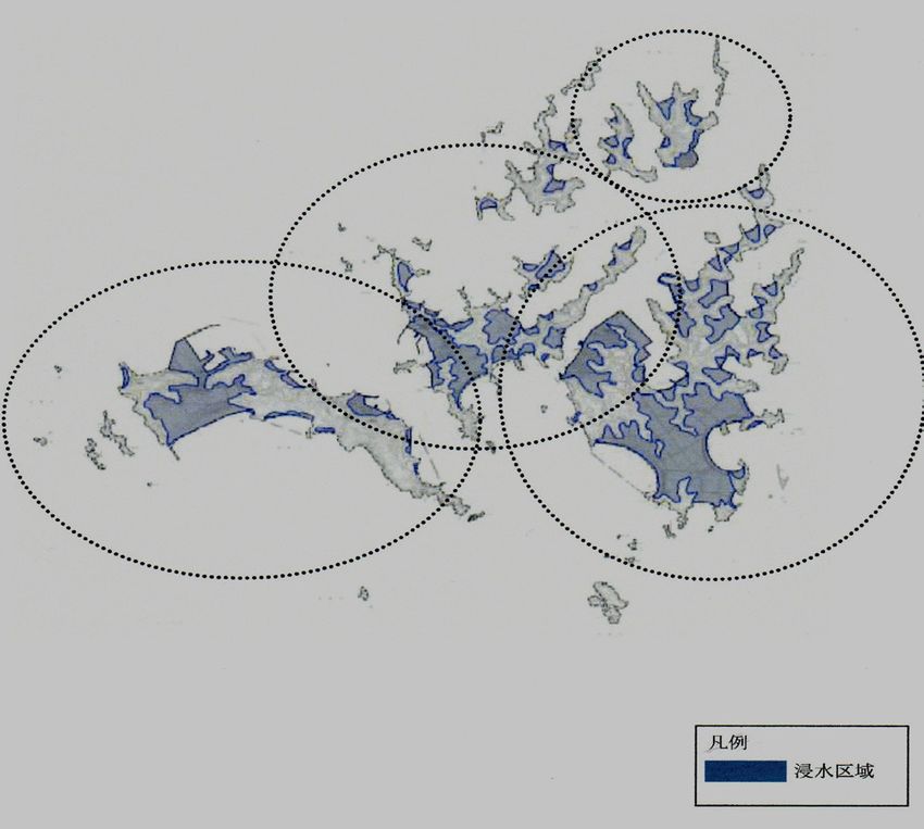
38 Disaster Management and Human Health Risk III

underwater depth of approximately 32km. It was the most powerful known
earthquake ever to have hit Japan, and one of the five most powerful earthquakes
occurring worldwide since modern record keeping began in 1900. The
earthquake triggered powerful tsunami waves that reached heights of up to
40.5 m in Miyako, Iwate Prefecture, while waves travelled up to 10 km inland in
the Sendai area. The earthquake moved the main island of Japan 2.4 m east and
shifted the Earth on its axis by estimates of between 10 and 25 cm. On
September 12, 2012, the Japanese National Police Agency confirmed about
15,900 deaths, 6,100 persons injured, and 2,700 persons missing across twenty
prefectures. They also reported that about 130,000 buildings had totally
collapsed, 254,200 buildings were “half collapsed,” and another 700,000
buildings were partially damaged. In response, the Bank of Japan offered ¥15
trillion (US $183 billion) to the banking system on March 14, 2011 in an effort
to normalize market conditions. The World Bank has estimated that the
economic cost of the disaster at approximately US $235 billion, making it the
costliest natural disaster in world history [1].

2 The great East Japan earthquake
Major earthquakes with accompanying large tsunamis previously struck the
Sanriku Coast region in 1896 and in 1933. The Great East Japan Earthquake,
which was caused by a 5–8 m up-thrust on a 180 km wide stretch of seabed 60
km off the Sanriku Coast, resulted in a major tsunami that inflicted destruction
along the Pacific coastline of all Japan's northern islands. Thousands of lives
were lost as entire towns were devastated. The tsunami propagated throughout
the Pacific Ocean region reaching the entire Pacific coast of North and South
America from Alaska to Chile. Warnings were issued and evacuations were
carried out in many countries bordering the Pacific, even though the affects were
minor. For example, Chile's Pacific coast, which is about 17,000 km away from
Japan, was struck by waves 2 m high, compared with an estimated wave height
of 38.9 m experienced on the east peninsula of Miyako City in Iwate prefecture.
Immediately after the earthquake, the Japan Meteorological Agency (JMA)
issued a “major tsunami” warning. This is the most serious warning on its scale,
and is defined as a prediction of waves at least three meters high. When it struck,
the tsunami inundated a total area of approximately 561 km2 of Japan. However,
a government study conducted in the aftermath of the disaster found that only
58% of people in coastal areas of Iwate, Miyagi, and Fukushima Prefectures
heeded the tsunami warnings immediately after the earthquake and began
evacuating to higher ground. Of those who decided to evacuate after hearing the
warning, only 5% were caught by the tsunami. Of those persons in the affected
area who ignored the warning, the tsunami waters hit 49%. Figure 1 shows the
Japanese archipelago [3].
   Although Japan has invested the equivalence of billions of dollars on anti-
tsunami seawalls, which line at least 40% of its 34,751 km coastline and stand up
to 12 m high, the tsunami simply washed over the top of many of them,
collapsing a number of them in the process. Damaged buildings included 29,500

    WIT Transactions on The Built Environment, Vol 133, © 2013 WIT Press
    www.witpress.com, ISSN 1743-3509 (on-line)
Disaster Management and Human Health Risk III     39

                                                                            Iwate
                                                                            prefecture
                                                                           Sanriku
                       Japan Sea                                           coast
                                                                            Miyagi
            N
                                                                            prefecture

                                                                             Fukushima
                                                                             prefecture
                                                               Tokyo
                                                    Pacific Ocean

                                 100km

                           Figure 1:         Japanese archipelago.

structures in Miyagi Prefecture, 12,500 in Iwate Prefecture and 2,400 in
Fukushima Prefecture. Three hundred hospitals with 20 beds or more were
damaged by the disaster, with 11 being completely destroyed. In addition, the
earthquake and tsunami created an estimated 24–25 million tons of rubble and
debris, and an estimated 230,000 automobiles and trucks were damaged or
destroyed in the disaster. As of the end of May 2011, residents of Iwate, Miyagi,
and Fukushima Prefectures had requested deregistration of 15,000 vehicles,
indicating that the vehicle owners had written them off as irreparable or
unsalvageable. All of Japan's ports were briefly closed after the earthquake, even
though those in Tokyo Bay and further south soon reopened. Fifteen ports of
Sendai, Shiogama, Souma, Kamaishi, etc. were located in the disaster zone. A
total of 319 fishing ports, comprising approximately 10% of Japan's total, were
damaged in the disaster. However, most had been restored to operation by April
18, 2012. The tsunami also ruptured the Fujinuma irrigation dam in Sukagawa

    WIT Transactions on The Built Environment, Vol 133, © 2013 WIT Press
    www.witpress.com, ISSN 1743-3509 (on-line)
40 Disaster Management and Human Health Risk III
City, Fukushima Prefecture, causing flooding that washed away five homes.
After the disaster, 252 dams were inspected and it was discovered that six
embankment dams had shallow cracks on their crests. The reservoir of one
concrete gravity dam was found to have suffered a small minor slope failure.
Currently, however, all those damaged dams are functioning without problems.
In the immediate aftermath of the disaster, at least 1.5 million households were
reported to have lost access to potable water. According to the Ministry of
Economy, Trade and Industry (METI), around 4.4 million households served by
Figure 2: Main disaster zone of Sanriku Coast.
WIT Transactions on The Built Environment, Vol 133, © 2013 WIT Press
www.witpress.com, ISSN 1743-3509 (on-line)Disaster Management and Human Health Risk III 41
Tohoku Electric Power (TEP) in northeastern Japan were left without electricity.
Further south, several nuclear and conventional power plants went offline after
the earthquake, reducing the total generating capacity of Tokyo Electric Power
Company (TEPCO) by 21 GW, and caused “rolling blackouts,” which began on
March 14 due to the resulting power shortages. The reactors at the Fukushima
No.1 and No.2 Nuclear Power Plants were automatically taken offline when the
first earthquake occurred, yet sustained major damage due to the subsequent
tsunami. The 30km radius around the nuclear power plants could not be assessed
in the immediate aftermath of the earthquake and tsunami. Many sections of the
Tohoku Expressway serving northern Japan were damaged as well. As for rail
services, the Tohoku Shinkansen line was worst hit, with JR East Railway Co.
estimating that 1,100 sections of the line, varying from collapsed station roofs to
bent power pylons, required repair. In Tokyo, all railway services were
suspended, leaving an estimated 20,000 people stranded at major stations across
the city. In the hours after the earthquake, some train services resumed, but most
lines serving the Tokyo area did not return to full service until the next day.
Various train services around other parts of Japan were also canceled, with JR
East suspending all its services nationwide for the remainder of the day. One
hour after the earthquake, the resulting tsunami swept over Sendai Airport
located on in the eastern part of the city, causing severe damage there [1].
Figure 2 shows the main disaster zone in the Sanriku Coast on May 14, 2011 [4].
3 Shiogama City case study
As previously mentioned, Shiogama City is located in Miyagi Prefecture and is
situated on the northeastern Sanriku Coast between the cosmopolitan city of
Sendai and Matsushima Bay, which is known as one of the three most famed
views in Japan. The city has prospered due to its harbor, which has been a
prominent center of maritime trade since the Meiji Era (1868–1912), even
though it has more recently evolved into a base for the local and deep-sea fishing
industries. Indeed, Shiogama City’s harbor boasts the largest unloading point for
fresh tuna in Japan, and its other enterprises ensure the city with an abundance of
other fresh seafood. In addition to being a popular tourist destination due to its
position as one of the doorways to Matsuhima Bay, Shiogama has more sushi
restaurants per square kilometer than anywhere else in Japan and leads the nation
in the production of steamed fish paste, kneaded fish cakes, as well as other
processed fish products. In 2012, the city’s population was 56,490, and the
number of households was 20,363. Shiogama City covers an area of 17.79 km2.
Figures 2(a) and (b) show overviews of Miyagi Prefecture and Shiogama City
[5, 6].
In 2010, 11.4% of the Shiogama City population was under 15 years of age
(6,437), 61.1% were citizens 15-64 years of age (34,451), while those citizens
aged 65 and older (15,481) accounted to 27.5% of the total. Of the 20,363 total
households in the city, 59.6% were nuclear family households (12,115),
independent households accounted for approximately 22.1% (4,500), elderly
WIT Transactions on The Built Environment, Vol 133, © 2013 WIT Press
www.witpress.com, ISSN 1743-3509 (on-line)42 Disaster Management and Human Health Risk III
Figure 3: (a): Miyagi Prefecture. (b): Shiogama City.
couple households accounted for 12.5% (2,525) and households consisting of
aged persons living alone accounted for 9.8% (1,998) of the total. As for the
housing conditions in Shiogama, of the 19,880 total residential units surveyed in
2008, 14,180 were family-owned residences and 5,570 were rental units. In
2009, the city hosted 3,285 offices and employed 23,259 persons broken down as
follows: primary industry, eight offices and 131 persons; secondary industries,
552 offices and 5,501 persons; tertiary industries, 2,725 offices and 17,627
persons. Damages resulting from the Great East Japan Earthquake in Shiogama
City were as follows: 47 persons deceased due to immediate affects (0.08%), and
another 10 persons deceased due to causes related to the disaster (0.02%).
Damages resulting from of the tsunami inundation affected 18,718 persons
(33.1%), 6,973 households (34.2%), 2,481 offices (75.5%) and 18,596
MatsushimaB
ay
Shiogama
Urato Islands
Hichirigahama
Tagajyou
Sendai Bay
Figure 4: Flooded areas (shadowed) in Shiogama City.
WIT Transactions on The Built Environment, Vol 133, © 2013 WIT Press
www.witpress.com, ISSN 1743-3509 (on-line)Disaster Management and Human Health Risk III 43
Houjima
Nonoshima
Sabusawajima
Katsurashima
Figure 5: Urato islands of Shiogama City.
employees (80%). The tsunami inundated approximately 27 ha of agricultural
land (37%) resulting in extensive damage to cultivated fields. Monetary damages
in Shiogama City related to traffic facilities, communication lifelines, housing,
education, medicine, etc., were estimated at approximately ¥0.1 billion (US $0.1
million) [7–9]. However, the city suffered slightly less damage than neighboring
municipalities (Tagajyou City, Hichirigahama Town, etc.) because nearby
offshore islands such as Katsurashima, Nonoshima, Sabusawajima and Houjima
of Urato islands absorbed and dissipated much of the tsunami’s force. Figure 4
shows an overview of the tsunami flooding in Shiogama City. Figure 5 is
offshore islands and shadowed parts are flooding areas.
4 Earthquake disaster reconstruction plans
The Reconstruction Agency is an administrative body of the Cabinet of Japan
established on February 2, 2012, to coordinate reconstruction activities related to
the Great East Japan Earthquake and the Fukushima Daiichi Nuclear Power Plant
disaster [10]. The Reconstruction Agency was established to replace the
Reconstruction Headquarters that was created on June 24, 2011, in response to
the Great East Japan Earthquake. At its founding, the Reconstruction Agency
was headed by then Prime Minister who took direct control of the agency in an
effort to strengthen the organization’s leadership. Although the Reconstruction
Agency is not a Cabinet Office, its authority extends over many other
government ministries. The Reconstruction Agency is scheduled to exist for ten
years, which was estimated to be the length of time necessary to fully restore the
WIT Transactions on The Built Environment, Vol 133, © 2013 WIT Press
www.witpress.com, ISSN 1743-3509 (on-line)44 Disaster Management and Human Health Risk III
region after the disaster, and is expected to be dissolved on March 3, 2021.
Currently, the Agency works out of three regional offices that were established
in Iwate, Miyagi, and Fukushima Prefectures, along with two smaller offices,
one in Hachinohe, Aomori Prefecture and the other in Mito, Ibaraki Prefecture.
The Agency has since forged ties with major Japanese business associations as
part of efforts to establish or revive economic activity in regions affected by the
earthquake, tsunami, and the nuclear disaster. One such effort is the
Reconstruction Design Council, which joins the Reconstruction Agency with the
Japan Business Federation, the Japan Association of Corporate Executives, the
Japan Chamber of Commerce and Industry, and their affiliated corporations [9].
Furthermore, the Agency also proposed an earthquake disaster reconstruction
plan for Shiogama City, which aimed at reestablishing and ensuring safety there.
The basic plan calls for
(1) regenerating the local infrastructure and constructing a community spirit that
fosters cooperation among diverse support groups,
(2) promoting a citizen-based community where people can resist disasters so
that all residents can live in safety,
(3) regenerating and reconstructing basic industries, commerce and
infrastructure, including tourism-related enterprises,
(4) other actions as necessary to stimulate the regional economy.
The basic policies of the plan center on the following:
(1) Housing and lifestyle reconstruction, including rehabilitation and
reconstruction of damaged/destroyed residences, promoting and maintaining
employment, providing economic support to victims, as well as reviving and
rebuilding public services.
(2) Improving community safety by enhancing the security and maintainability
of the residential environments, reconstructing public facilities, reconstructing
and stabilizing city functions and infrastructure, with specific emphasis on areas
affected by the tsunami.
(3) Revitalizing commerce and other areas of the economy by rebuilding and
reconstructing key industries, rebuilding and revitalizing commercial
infrastructure, promoting tourism, and creating a new support system at the
national and prefectural level.
(4) Addressing issues related to radioactive fallout. This includes promoting
security, dependable civil service, and countermeasures to radioactivity tailored
to ensuring safe industrial development.
(5) Reviving of other parts of the district (included offshore islands) that suffered
serious damage due to the earthquake and tsunami.
In all areas, rehabilitation support will include repair or reconstruction where
necessary including revitalization of basic services, reconstruction and repair of
damaged island roadways, medical facilities, administrative services, and
industry. To strengthen the nation, it will be necessary for central government
agencies to join with prefectural, city, town, and village governments in the
affected areas to promote plans of this nature, and provide the human material
support required. It will also be necessary to promote cooperation at the citizen
and neighborhood association level, as well as within companies and enterprises.
WIT Transactions on The Built Environment, Vol 133, © 2013 WIT Press
www.witpress.com, ISSN 1743-3509 (on-line)Disaster Management and Human Health Risk III 45
Because of the massive expenses related to reconstruction, financing the
recovery is expected to remain an ongoing problem. It will also be important to
ensure flexibility and promote good ideas within the framework of the existing
systems, set and enforce goals based on clear appraisals of the damages, and
conduct period evaluations to ensure proper progress is being made.
5 Considerations
About the time when restoration, the revival from East Japan great earthquake
disaster is completed according to the Asahi Newspaper dated March 1, 2013
[11], it was announced in the questionnaire result that the half of the chief of 42
cities, towns and villages in three prefectures where we will be suffered over 6-
10 years later. The 6.8 (Mw) Great Hanshin Earthquake, also known as the Kobe
Earthquake, occurred on January 17, 1995, in the southern part of Hyogo
Prefecture [12]. The focus of the earthquake was located 16 km beneath its
epicenter, on the northern end of Awaji Island, approximately 20 km away from
the city of Kobe. Approximately 6,434 people lost their lives (final estimate as of
December 22, 2005), of which approximately 4,600 were Kobe residents.
Among the major cities affected, Kobe, with its population of 1.5 million, was
the closest to the epicenter and was hit by the strongest tremors. At that time, it
was Japan's second worst earthquake (after the Great Kanto Earthquake of 1923,
which claimed 140,000 lives [13]). The Kobe Earthquake caused approximately
10 trillion (US $100 billion) in damage, which amounted to approximately 2.5%
of Japan's GDP at the time. Nevertheless, the city of Kobe recovered due to
energetic government office and civic activities, and the main economic
indicators for the entire region, such as population, manufacturing sector
production, tourism, and consumer spending, have all returned to levels that
approximate those before the event. However, it should be noted that damage to
Kobe City resulted from the earthquake alone, while Shiogama City and other
areas affected by the Great East Japan Earthquake also suffered tsunami damage,
along with the issue of radioactive fallout from the Fukushima Nuclear Power
Plant accidents. Accordingly, the disaster restoration methods and time required
for revival in the latter case can be expected to be different. It is necessary to
reflect on the historical experiences and lessons learned from Great East Japan
Earthquake and Great Hanshin Earthquake disasters in order to contribute to
mitigating future damage from domestic and international disasters. It should
also be noted that, even though the Great Kanto Earthquake of 1923 [12] and the
Great Hanshin Earthquake of 1975 [13] were huge disasters, the Great East
Japan Earthquake was significantly different because it paralyzed and
depopulated numerous local governments simultaneously. In addition, it marked
the first time the Japanese Government faced challenges related to reviving
disaster stricken areas in an era experiencing an ongoing population decline. It is
also noteworthy that all of these factors were somewhat overshadowed by the
nuclear plant accidents. Thus, the degree of difficulty faced by persons and
organizations involved in recovery efforts is unprecedented, and ideas that are
fundamentally different from those used in past recovery efforts will be required.
WIT Transactions on The Built Environment, Vol 133, © 2013 WIT Press
www.witpress.com, ISSN 1743-3509 (on-line)46 Disaster Management and Human Health Risk III
It is necessary to consider the implementation of those steps in terms of:
prevention, mitigation, evacuation, relocation and sheltering.
6 Conclusions
At present, approximately 360,000 people continue to reside in evacuation
shelters set up in the aftermath of the Great East Japan Earthquake. Meanwhile,
the population outflow from the stricken area continues, and while public
construction efforts are robust and ongoing, numerous people are unable to find
hope there. The stricken area has been hit by tsunami many times in the past, and
towns in the area that subsist primarily on marine product industries have
recovered each time. Despite this, according to the recent public opinion poll,
approximately 50% of those residing in the area hope “to move to other
locations” in the future. Additionally, since it has been decided that new housing
will be constructed on the hilly lands above tsunami danger areas, those who
intend to remain in the area can expect to wait another two to three years for
house construction, and thus must continue to reside in temporary housing until
then. Population levels have decreased in other affected cities, towns and villages
along the Sanriku Coast, with most of the departures consisting of persons less
than 30 years of age. Aggravating the problem in the depopulated region has
been the percentage-wise increase in aged persons, and a shortfall of persons
able to provide support for victims. Another shortfall has been in the availability
of construction materials necessary for recovery efforts, primarily because of the
massive amount of public works underway. The hard power required for the
construction of roads, houses, railways, etc. is plentiful, but the soft power
required for negotiation of lands or houses is drastically short. It may be difficult
that the past life will be revived, but the reconstruction will be premature by the
wisdom and the effort of people.
References
[1] Wikipedia, the free encyclopedia, 2011 Tohoku earthquake and tsunami,
http://en.wikipedia.org/wiki/2011-T%c5%8dhoku-earthquake-and-tsunami
(2013/02/24)
[2] Wikipedia, the free encyclopedia, Reconstruction Agency,
http://en.wikipedia.org/wiki/Reconstruction-Agency (2013/02/28)
[3] Wikipedia, the free encyclopedia, Japan, http://en.wikipedia.org/wiki/Japan
(2011/02/24)
[4] A. Martin, Japan Convulses, Grieves, Moves On, The Japan Times Special
Report (2011/03/11)
[5] Shiogama City, About Shiogama, http://www.city.shiogama.miyagti.jp
/shiogama/index.html. (2013/02/26)
[6] Images of Matsushima bay Map, bing.com/image
[7] Shiogama City, Reconstruction plan of the Shiogama City caused by the
Great East Japan Earthquake Disaster, Shiogama City, 2012
WIT Transactions on The Built Environment, Vol 133, © 2013 WIT Press
www.witpress.com, ISSN 1743-3509 (on-line)Disaster Management and Human Health Risk III 47
[8] Ministry of Land, Infrastructure and Transport, Outline of reconstruction
pattern in Shiogama City corresponding to the Great East Japan
Earthquake Disaster, http://www.mlit.go.jp/common/000209550.pdf.
(2013/03/09) (In Japanese)
[9] H. Etoh, Appearance of disaster municipality in the Great East Japan
earthquake by statistics and map, Japan Statistical Association, 2013
[10] Wikipedia, the free encyclopedia, Reconstruction Agency,
http://en.wikipedia.org/wiki/Reconstruction-Agency (2013/02/28)
[11] Asahi Newspaper, Dappled effect of reconstruction plans, (2013/3/1)
[12] Wikipedia, the free encyclopedia, Great Hanshin Earthquake,
http://en.wikipedia.org/wiki/Great-Hanshin-earthquake (2013/03/09)
[13] Wikipedia, the free encyclopedia, 1923 Great Kanto Earthquake,
http://en.wikipedia.org/wiki/1923-Great-Kanto-earthquake (2013/03/09)
WIT Transactions on The Built Environment, Vol 133, © 2013 WIT Press
www.witpress.com, ISSN 1743-3509 (on-line)You can also read