EEPSEA 2016-SRG3 - Payment for Ecosystem Services in Thailand and Lao PDR
←
→
Page content transcription
If your browser does not render page correctly, please read the page content below

EEPSEA
                                              2016-
                                                  SRG3

Paymentf
       orEc
          osyst
              em Ser
                   vic
                     es
i
nThail
     andandLaoPDR
RawadeeJar
         ungrat
              tanapong,
                      Phums
                          ithMahas
                                 uweer
                                     achai
                                         ,
OrapanNabangc
            hang


PAYMENT FOR ECOSYSTEM SERVICES IN THAILAND AND LAO PDR

                 Rawadee Jarungrattanapong, Phumsith Mahasuweerachai, Orapan Nabangchang

                                                          EXECUTIVE SUMMARY

         Payment for ecosystem services (PES) is a new approach that has seen growing interest in
conservation. The definition of PES in this report is given by Wunder (2005, p. 3) as “a voluntary transaction
where a well-defined environmental service or a land use likely to secure that service is being ‘bought’ by a
minimum of one service buyer from a minimum of one service provider if and only if the service provider
secures service provision (conditionality).”

         This report aims to review PES implementation in Thailand and Lao PDR and to draw lessons from
the case studies. Although the projects in Thailand and Lao PDR that have been identified and discussed in
this report produce ecosystems services, they lack many of the components of full PES projects as provided
by the definition of Wunder (2005). Thus, we refer to these cases as “PES-like.” In the case of Thailand, most
of the funds for natural resources conservation are primarily corporate social responsibility investments.
However, investors do not directly benefit from the ecosystems services they are paying for; donations have
tended to be one-time investments with no guarantee of continuity in funding. In addition, PES-like projects
related to wildlife has the potential to generate voluntary contribution from private companies or from the
general public; flows of contributions from these sources are unlikely for ecosystems services such as
watersheds, mangroves, wetlands, etc. This is because it is difficult for the general public to understand the
importance of such ecosystem services. The challenge then is how to demonstrate the direct and indirect
benefits of ecosystems services in order to create a real public demand.

         PES cases in Lao PDR are also at the design stage; however, the mining and hydro-power projects of
private sectors in Lao PDR have developed their own incentive or benefit-sharing mechanisms, which
depend on the outcome of negotiations for concession agreements. Moreover, the Government of Lao PDR
has shown strong interest in the PES mechanism. The main constraint in Lao PDR is not the legal issue itself,
but rather the lack of human and financial capacity to implement PES.

                                                          1.0 INTRODUCTION

         Payment for ecosystem services (PES) is an innovation that uses financial markets to provide
incentives for improving environmental management (Smith et al. 2006; Wunder, Enger, and Pagiola 2008).
There is growing interest in using the PES approach in conservation, especially in the classical case of
watershed protection. It emerged when it was becoming obvious that, as a result of budget constraints in
many jurisdictions, the common approach (e.g., command-and-control measures) could not provide enough
funds for conservation from government sources. PES can provide a new source of funding, especially if the
private sector and service-providing communities can improve their livelihoods from investing their funds in
this way (Wunder, Enger, and Pagiola 2008). Although the PES concept has gained increasing attention over
the past decade, a review of PES implementation in Thailand and Lao PDR is still missing. This PES review will
help us to better understand and recognize the necessary preconditions for an effective PES scheme, and to
use these conditions to develop a framework for assessing opportunities and evaluating the feasibility of
implementing a PES scheme in the future.

1    Economy and Environment Program for Southeast Asia
1.1 Research Objective
The objective of this project is to review the PES implementation in Thailand and Lao PDR.
Specifically, this study aimed
1. To review PES policy and implementation experiences in Thailand and Lao PDR;
2. To identify success and constraining factors in Thailand and Lao PDR based on literature review, and
to document cases of PES implementation;
3. To report on a selection of 3–4 cases for detailed in-depth interviews of relevant stakeholders.
1.2 Research Methods
A review of existing PES documents, site visits, and interviews with relevant stakeholders were
undertaken to collect the data and information.
1.3 Rationale for Choosing the Cases
The PES-like cases in this study were chosen based on three factors: (1) the cases matched many of
the criteria in the definition of PES 1, but not all of them (Wunder 2007); (2) the cases had already been
implemented, and (3) details of the cases were available.
2.0 BACKGROUND OF PES IN THAILAND
Unlike other countries in Southeast Asia, Thailand has no practical experience in implementing the
PES concept although there are PES projects being designed. There have been studies of academic nature as
well as pilot studies. The latter, such as the Khao Ang Rue Nai PES project selected for study in this report,
had been supported by public agencies with the original intention of launching pilot projects; however,
these never really progressed beyond the publication of the project report. The PES projects initiated by the
United Nations Development Project (UNDP) are likely to result in concrete action but all of these are in the
“design stage.” Having said that, at the national policy level, the 11th National Economic and Social
Development Plan nevertheless acknowledges the value of PES as one possible natural resources
management option. Furthermore, there are “institutional” interests from international organizations such
as the World Wildlife Fund (WWF), the International Union for the Conservation of Nature (IUCN), and the
ECOBEST on the use of economic instruments to create incentives for natural resources conservation and
improvement of environmental quality.
2.1 Legal Framework Related to PES in Thailand
At present, no legal framework pertains directly to PES, although some laws directly apply to the
management of specific types of land that are likely to be PES sites (Table 1). Almost all of the existing
PES-like projects, as well as PES projects being designed, are located in public lands covered by different
pieces of legislation and varying levels of protection, such as the 1961 National Park Act, the 1964 National
Forest Reserve Act, the 1992 Wildlife Protection and Preservation Act, the 1954 Land Code, and the 1975
Treasury Act. To enforce these laws, ministerial orders, rules, and regulations have been issued, laying down
the details of rights, responsibilities, and restrictions on access to various types of public land and penalties
for violation. These laws were designed to protect natural resources; the stipulations in these laws therefore
aim to prohibit access and to penalize noncompliance. Thus, if PES projects are to be implemented in areas
subject to these restrictions, some amendments or exemptions will have to be made to allow service
providers to carry out measures in these areas that entail “legal” entry restrictions. The various pieces of
legislation related to these areas with potential as sources of ecosystems services, as well as laws that
support the role of local communities in looking after natural resources are summarized in the table below.
1
The formal definition of PES is identified by Wunder (2005, p. 3) as “(1) a voluntary transaction where (2) a well-defined environmental
service (ES) or a land use likely to secure that service (3) is being ‘bought’ by a minimum one service buyer (4) from a minimum one
service provider (5) if and only if the service provider secures service provision (conditionality)”.
Payment for Ecosystem Services in Thailand and Lao PDR 2Table 1. Laws related to the management of natural resources in Thailand
Law Key Principles
National Park Act, 1961 The National Park Act provides for the establishment of both terrestrial and
marine national parks for biodiversity conservation. Entry on a visitor basis is
allowed but other forms of uses are prohibited, such as residence, hunting,
clearing, gathering of vegetation, mining, and the introduction of livestock
within park boundaries.
Wildlife Preservation The Act was enacted in 1960 with the principal objective of conserving and
and Protection Act, 1960 protecting wildlife, expanding wildlife breeding, and ensuring that wildlife
(amended in 1992) protection and conservation measures are in accordance with international
agreements. The Act also stipulates rules governing hunting and trading of
wild animals and lists protected species. The Act was amended in 1992 to
provide for the establishment of wildlife sanctuaries as primarily wildlife
conservation areas under the jurisdiction of the Department of National
Parks, Wildlife and Plant Conservation. As in the National Park Act, no forms
of residence or extractive use are allowed within wildlife sanctuaries. Entry is
restricted only for education and research purposes and is subject to
notification of authorities.
National Forest Reserve The objective of the Act is to protect the state of the forest and natural resources
Act, 1964 (amended in within the forest by designating areas as National Forest Reserves and
1992) permitting utilization only in areas outside of these reserves.
The amendment of this Act in 1992 resulted in the classification of National
Forest Reserves into three zones, i.e., Conservation Forest, Economic Forest,
and Agricultural Use Forest. By definition, Conservation Forests cover
protected areas and areas of ecological importance such as Class I
watersheds. Access and utilization is permitted for Economic Forests, which
are generally used for commercial forestry.
Constitution of the The Constitution defines the rights and entitlements of individuals over natural
Kingdom of Thailand, resources, and can be used as reference to justify roles of individuals or
2007 groups of individuals as service providers.
2.2 Policy Framework
While there are no specific laws on PES, the concept is endorsed within the current 11th National
Economic and Social Development Plan (NESDP) covering the period 2012–2016. In this Plan, PES is
recognized as an instrument for creating incentives for natural resources conservation.
At the policy level, two agencies are involved in implementation. The first is the National Economic
and Social Development Board (NESDB), which is a macro-level planning body responsible for formulating
the Five-Year Social and Economic Development Plans. The second is the Office of Natural Resources and
Environmental Policy and Planning (ONEP) of the Ministry of Natural Resources and Environment (MONRE).
ONEP serves as the secretariat of the National Environmental Board (NEB). As the agency responsible for
coordination of issues related to natural resources management, it could play a greater role in advocating
PES. Furthermore, the mandate of one of its three divisions—the Environmental Quality Management Sector
(EQMS)—is to monitor, control, supervise and promote incentives for the prevention and remedy of
environmental problems. Being the division responsible for the management of Thailand’s Environmental
Fund, EQMS could play a potentially critical role in financing mechanisms for PES in Thailand. In addition,
ONEP is the agency that formulated the National Policy, Measures, and Plans on the Conservation and
Sustainable Utilization of Biological Diversity (1998–2002), which is considered as the principal framework
for biodiversity conservation and management in Thailand. PES will be of direct relevance to ONEP,
particularly to the Regional Environmental Management Sector, which is responsible for the management of
biological resources.
As mentioned earlier, although Thailand does not have ongoing PES projects, some are at the
design stage of development. The significance of these projects is that they will be the first PES projects to
be implemented in Thailand. Altogether, 16 projects can be said to be at the initial stages. These include four
3 Economy and Environment Program for Southeast Asiapilot projects under the Community-Based Forestry and Catchment Management (CBFCM) program, which
is funded by the UNDP-Global Environment Fund (UNDP-GEF), and five projects under the Catalysing
Sustainability of Thailand’s Protected Area System (CATSPA), which also receive financial and technical
support from the UNDP-GEF. Three public agencies organized within MONRE will be closely involved in the
design and implementation of these projects, namely, the Department of National Parks, Wildlife and Plant
Conservation (DNP), Regional Environment Offices (REO), and the Department of Marine and Coastal
Resources (DMCR).
Firstly, DNP’s role in PES implementation is significant because the agency is responsible for
managing environmental and biodiversity hotspots, most of which are located within terrestrial or marine
parks. Moreover, the PES concept is consistent with DNP’s key strategy to adopt participatory approaches to
integrated watershed management, including developing the economic welfare of people in watersheds.
Secondly, REOs are the main counterparts of the PES project currently being designed under the CBFCM
project. This structure may be due the mandate of each REO, which is to coordinate the provincial
governments and other relevant government agencies, including the Royal Department of Forestry and
DNP, for the effective management of the environment. Nationwide, there are 16 REOs, four of which are
now acting as CBFCM project counterparts in the four PES pilot project sites. Finally, DMCR will play a key
role in PES projects that involve conservation of coastal and marine resources, such as the Tarutao site
(CATSPA) and Phangan Island site (CBFCM).
3.0 PES STUDIES IN THAILAND
The four PES cases under study include three PES pilot projects launched under the broader CBFCM
framework, and the PES study project supported by the Biodiversity Economy-Based Development
Organization (BEDO) designed to generate experience and lessons in the case of ecosystem restoration and
wildlife conservation.
The three CBFCM initiatives to launch PES concepts in Thailand include one in which the UNDP is a
key player; another entitled Sustainable Financing of Protected Area: Catalyzing Sustainability of Thailand’s PA
System, started in January 2011; and a third one entitled Sustainable Production and Marketing: Sustainable
Management of Biodiversity in Thailand’s Production Landscape, which was originally planned to be launched
in October 2011.
The CBFCM project supported by the UNDP has been designed to promote the use of economic
incentives to local communities to conserve biodiversity and to reduce greenhouse gas (GHG) emissions
from land uses. The goal, objective, and outcomes were intended to support the goals of the United Nations
Partnership Framework with the Kingdom of Thailand (2007–2011) by promoting capacity building at the
local level for environmental management, sustainable resource use, and cleaner energy. This project fulfills
part of the UNDP’s Country Programme Action Plan (2007–2011) for Thailand under the Energy and
Environment Outcomes, which include
1. efficient community-based natural resources and environmental management in selected
ecosystems;
2. increased capacity of national agencies to set policy priorities and remove barriers to pursuing
sustainable management of biodiversity, renewable energy, and water resources; and
3. promoting community-based knowledge management by supporting the formation of community
networks and promoting evidenced-based policy making at all levels.
The launch of this project was said to have been driven by country needs as MONRE identified it as a
high-priority national project; it satisfied Thailand’s GEF strategy of providing support to the implementation
of the 10th NESDP (2007–2011). Further, this project is consistent with the 11th NESDP (2012–2016), which
emphasizes the following:
1. the importance of sustainable management of natural resources and environment toward
sustainability;
2. restoring and securing natural resource and environment bases;
Payment for Ecosystem Services in Thailand and Lao PDR 43. enhancing adaptive capacity to achieve climate-resilient society; and
4. enhancing good governance in natural resource management.
The project is anchored on Target 9 of the Millennium Development Goal 7 (MDG7), which aims to
integrate sustainable development into country policies and programs and to reverse the loss of
environmental resources. The relationship between natural resource and environmental management and
GHG can be synthesized from the National Strategy on Management of Climate Change and the four-year
operational plan of MONRE. Under the CBFCM project, three sites were identified to pilot the PES concept.
The information presented below is output from the first six months of what is planned to be a four-year
project.
3.1 Koh Phangan, Suratthani Province
3.1.1 Baseline situation
Koh Phangan is an island district in Suratthani province, which is situated within the Gulf of
Thailand, and covering an area of 168 km2. The physical topography of the island consists of forested
mountainous terrain in the middle of the island, which is the source of water for the entire island. Most of the
area is designated as National Forest Reserve. Another two-thirds of the area around the island is flat
lowland with 13% of the total area on this island being privately owned. The economy is primarily based on
tourism, followed by fishing and agriculture (primarily coconut growing). Thirteen of the island’s villages are
based on fishing, and there is one agricultural cooperative. Every village has a savings bank, with funds
coming from village fund projects derived from the Community Development Department.
Koh Phangan islands consist of 10 islands (Figure 1), namely, Phangan, Tae Nok, Tae Nai, Tao, Nang
Yuan, Mah, Hin Bai, Kong Kliangan, Wao Yai, and Tung Goo. The only two islands where there are human
settlements are Phangan and Tao.
The PES pilot project covers only Phangan Island, which is the second largest island in the Gulf of
Thailand, after Samui Island. The island is located 70 km from the country’s coast. The island’s total area is
168 km2 and most of the 63 km2 of forests has been declared as part of Tharn Sadej-Koh Phangan National
Park. Although there are problems of encroachment, most of the natural forests are still in relatively good
condition, particularly the watersheds, which are the main water source of various short streams that
provide freshwater supply. Because the physical terrain is mainly mountainous, only 13% of the land is
occupied.
Koh Phangan has a diversity of ecosystems from forest to estuaries and coral reefs. All of the island’s
ecosystems are facing mounting pressures from the rapidly growing tourism and related land development
activities (Figure 2), including the growing volume of solid waste and uncontrolled discharges of wastewater
into the sea. Increasing tourism activities on and under the sea, coupled with the rising density of
development and people along the beaches, are directly linked to declining seawater quality that is
affecting marine ecosystems.
Phangan Island is divided into three subdistricts and is administered by three municipalities.
The total registered population is 17,203, although the actual population would be much higher due to a
large number of Burmese workers on both Phangan and Tao. Both islands are also major tourist destinations.
The economy of Phangan is driven solely by tourism. Although there is diversity of attractions of
historical and cultural interest, the main attractions are beach and sea-based recreational activities. What the
island is best known for is the Full Moon party held monthly on Haad Rin beach, bringing in more than
30,000 tourists every month.
5 Economy and Environment Program for Southeast AsiaFigure 1. Koh Phangan Island
Figure 2. Land use in Phangan Island
3.1.2 The driver of this PES project
The decision to include Koh Phangan as one of the pilot sites is a combination of the physical
characteristics of the island and institutional considerations, including the following:
1. The types of ecosystems that can be found, from watershed forests to coastal and marine
ecosystems;
2. The decline in ecosystems services, likely resulting from both land-based pollution and sea-based
activities, such as fishing and tourism;
3. The potential to introduce economic instruments that can generate funds to finance conservation
activities and to ensure sustainable benefits from ecosystems services; and
4. Existence of some baseline data on the “status quo” situation, i.e., detailed survey of the state of
coral reefs and inventory of marine biodiversity by Sakanand Platong.
3.1.3 The PES pilot project components
A skeletal structure of the PES Project for Phangan Island was drafted based on the above
considerations, and through a series of field visits and consultations with local stakeholders in the island as
well as meetings with REO counterparts and UNDP representative. For Phangan, the two environmental
services identified were (1) water quality improvement (Table 2) and (2) natural resources and environmental
quality management for sustainability (Table 3).
Payment for Ecosystem Services in Thailand and Lao PDR 6Table 2. PES mechanism for water quality improvement in Koh Phangan
Attribute Description
Actions that will lead to 1. Waste separation (producing organic fertilizer from kitchen waste)
provision of ES 2. Producing organic fertilizer from seaweeds, seagrass
Indicator of improvement in Changes in concentration of nitrogen and phosphorus in six major
environmental quality locations:
1. Chaloklam Bay
2. Nai Wok Canal
3. Haad Rin beach
4. The old pier at Thong Sala
5. Bang Jaru Canal
6. Bang Nayok Canal
Service providers 1. Phangan island organic farm group
2. Haad Rin Business Operators Association
Beneficiaries
Tourism-related private businesses
and potential buyers
Intermediary Municipality at the subdistrict Level
Existing data Data on water quality from the 17 collecting stations
Data requirement 1. Data on water quality from various points in the canals/streams on
for detailed design the island itself
of PES project 2. Verification of the effectiveness of the use of bio-fermentation to
treat wastewater (which may just be a matter of testing
concentration of selected parameters before and after treatment)
3. Cost estimation for the activities to be undertaken
Table 3. PES scheme for natural resources and environmental quality management for sustainability
in Koh Phangan
Attribute Description
Actions that will lead 1. Stop trawlers violating the 5-kilometer no-take zone in coastal
to provision of ES waters
2. Expanding area of mangrove replanting
3. Coral reef conservation and restoration, including additional
investments in artificial reefs; locations will include both snorkeling
and scuba diving sites (although exact locations are yet to be
determined)
Location 1. Fishery: Chaloklam Bay
2. Mangrove: Wok Tum Bay
3. Coral reefs restoration: to be determined by the DMCR based on
physical and technical feasibility
Indicator of improvement 1. Fishery: Statistics on species type and quantity caught
in environmental quality 2. Mangrove:
• Absolute increase in mangrove area
• Changes in carbon stock
• Changes in species diversity
3. Coral reefs restoration
• Areas where coral reefs have been restored
• Number of artificial reef sites created
• Species diversity and density
Service providers 1. Fishery: Small-scale fisherfolk who would be willing to accept the
compensation/reward money
2. Mangrove: Local people who would be willing to accept the
compensation/reward money
• Planting and measure changes in carbon stock
• Building a database of biodiversity resources
7 Economy and Environment Program for Southeast AsiaTable 3 continued
Attribute Description
Service providers 3. Coral reefs restoration:
• Scuba diver volunteers
• Save Koh Tao
• Phangan Coral Reefs Conservation Group
Beneficiaries and potential 1. Fishery: Small-scale fisherfolk who would be willing to pay for the
buyers “coastal watch services”
2. Mangrove: Not yet clear due to the very small scale of replanting
3. Coral reef restoration:
• Tourism-related businesses
• Businesses offering snorkeling and scuba diving services
• Those involved in transportation services such as boat-crossing
operators and airlines (e.g., Bangkok Airways, Thai Airways)
• Contribution from general public; this is because given the
uniqueness of the natural resources of Koh Phangan, the
general public may attach high value to its preservation, thus
the nonuse value may constitute a large share of the total
economic value of the island’s ecosystem
• Potential buyers could also include companies who wish to
invest in corporate social responsibility (CSR) activities.
Many private business operators may understand that the
initiatives they have already undertaken to “Go Green” or social
CSR activities, such as building schools, etc., are already acts of
contribution to the provision of “public good.” Under the Koh
Phangnan PES pilot project, the intention for businesses would
be to channel investments into conservation activities, which
would ultimately provide assurance for the sustainability of
their businesses.
Intermediary Mangrove: Municipality to be involved in recruitment of service
providers (possibly through auction)
Existing data Fishery
• No baseline data exist on the number of incidences where
trawlers violate the no-take zone, and no estimates have been
made of the volume and value of catch associated with these
violations
• No baseline data on the volume and value of catch by the
small-scale fisherfolk
• Mangrove: No existing database either about the mangroves
(types, species, etc.) or the biodiversity of resources that can be
found.
• Coral reefs: There are comprehensive data on the coral reefs of
Phangan (types, composition, density, the state of bleaching);
there is also information about diversity of marine life that can
be found in the reefs
Data requirement for detailed 1. Fishery: The database on use value from fisheries will have to be
design of PES project created since none exist on the following:
• Types of fish, volume, and market price
• Number of small-scale fisherfolk, fishing efforts, and related
expenses
• Number of trawlers that violate the no-take zone
• Information on costs of implementing a “coastal watch”
(man-days, boats, petrol, necessary equipment)
Payment for Ecosystem Services in Thailand and Lao PDR 8Table 3 continued
Attribute Description
Data requirement for detailed 2. Mangrove
design of PES project • Suitable types and species
• Information on various types of cost (i.e., planting, replanting,
monitoring, and other operational expenses)
• Information and technology dissemination on planting,
monitoring growth, and measurement of carbon stock
3. Coral Reefs
• Verification of suitable locations for replanting or installing
artificial reef sites
• Updating costs for replanting or installing artificial reef sites
• Cost estimation for monitoring changes in the state coral reefs
and marine life
3.1.4 Payment scheme, monitoring, and actors
A payment scheme does not exist yet, but there is a need to determine whether payment will be
equated with “inputs” or “outputs.” Meanwhile, monitoring is acknowledged to be conditionality built into
the contract to meet the “additionality” criteria.
The service providers, the potential buyers, and intermediaries have been identified for the specific
ecosystem services. Due to the institutional arrangement with the UNDP, one key player for all of these pilot
projects will be the Pollution Control Department (PCD). Other public agencies will be involved in providing
technical backstopping where necessary. Although the details of the involvement of service providers or
potential buyers have not been discussed, a Koh Phangan CBFCM Group has been established, and regular
consultation meetings have been undertaken, although these meetings are not yet considered part of the
“formal” process of the project.
3.1.5 Problems encountered
Being in its design stage, the organizational setup of the project remains a major obstacle; this is
true for all four PES projects under the CBFCM framework, although problems in coordination are more
acute in some than in others. People such as Pagiola 2 have observed that PES is not a panacea for all
environmental ills; some problems related to the coastal and marine environments can be served better by
other economic instruments (e.g., user charges, clarification of property rights).
3.2. Tha Chin River Basin
3.2.1 Baseline Situation
The Tha Chin River is a tributary of the Chao Phraya River (Figure 3). The River is 325 km in length
and flows through four provinces (Chainat, Suphanburi, Nakorn Prathom, and Samut Sakorn). The two
upstream provinces of Chainat and Suphanburi have some of the most fertile agricultural lands in the
country, while the lower two provinces have some highly industrialized zones. About 67% of the Tha Chin
River Basin is used for agriculture. The primary uses of the river include water supply, aquaculture,
transportation, recreation, and as a sink for wastewater discharges.
2
Pagiola is an environmental economist well known for his contribution and work on the concepts and application of PES (e.g., Pagiola
and Platais 2002).
9 Economy and Environment Program for Southeast AsiaFigure 3. Tha Chin River Basin
3.2.2 The driver of this PES project
The initial pilot site focused on the lower Tha Chin catchment basin, which is a wetland area of
national significance. The entire river basin is a major food-production area for the country. Although there
are land-use zoning and planning laws to protect agricultural zones and green areas, there is tremendous
pressure within the basin to convert the remaining green space—including natural areas of wetland,
mangrove forests, open space, agricultural land, etc.—into agriculture (such as water spinach farming),
construction of industrial estates, housing estates, condominiums, and tourism facilities (e.g., “floating
markets” for the tourist market). River water quality has steadily deteriorated due to uncontrolled
wastewater discharge from the industrial, agricultural, and commercial sectors.
Despite the large spatial extent of the catchment area, the nature of the project as a “pilot” means
that in order to be clear about the path of the ES being disrupted by water quality deterioration, there is a
need for a reduced physical scope for the PES site(s). This small scale also means the ability to limit the
number of service providers and buyers to focus understanding about how best to deliver the service.
The decision was therefore to limit the spatial scope to just Samut Sakhon province, where the Tha Chin
River flows into the sea; the site focuses on the canals flanking Tha Chin, namely, Pittayalongkorn canal on
the left and Sunak Hon canal on the right. The reason for this is that the water quality at the river outlet was
observed to be worse compared to other parts of the river. Poor water quality not only restricts the use of
water by local communities, but is also believed to have direct impacts on coastal fisheries. Another reason
for the selection of this portion of Tha Chin is the presence of two or three networks of local people who are
already taking some measures to improve the water quality and who could therefore easily become service
providers. Members of these groups have not been given any compensation or reward; involvement has
been entirely on a voluntary basis.
3.2.3 The PES Pilot Project Components
For Tha Chin, the two environmental services are (1) water quality improvement (Table 4) and
(2) mangrove restoration (Table 5). Details of the project design at this stage are summarized in Table 4.
Payment for Ecosystem Services in Thailand and Lao PDR 10Table 4. PES mechanism for water quality improvement in Tha Chin River Basin
Attribute Description
Actions that will lead Improvement of water quality along the banks of the tributaries before the water
to provision of ES is drained into the Tha Chin River by:
• Planting vegetation along the river bank to act as buffer from pollution by
the fish-processing plants concentrated in this area
• Dissemination of low-cost technology for treating wastewater, such as
biological fermentation
Indicator of 1. Improvement of water quality in Bang Ya Praek and Kok Kham subdistricts
improvement in 2. Increase in number of fish cleaning and processing plants in Bang Ya Praek
environmental quality and Kok Kham subdistricts
Service providers 1. Local communities of the three subdistricts along the Pittayalongkorn canal,
namely, Bang Ya Praek, Kok Kham and Phan Tai Norasingh
2. Local conservation groups and local youth groups
Beneficiaries and The fish cleaning and processing plants in Bang Ya Praek and Kok Kham
potential buyers subdistricts
Intermediary 1. REO Office 5
2. Samut Sakhon Natural Resources and Environment Office
3. Local governments, namely, Bang Ya Praek Tambon municipality and Kok
Kham Tambon Administration Organization PR
Existing data No existing data on water quality or pollution loads in the area
Data requirement 1. Information about water quality in Pittayalongkorn canal
for detailed design 2. Information about water quality in the tributary canals in Bang Ya Praek and
of PES project Kok Kham subdistrict
3. The number of fish-cleaning and -processing plants in Bang Ya Praek and Kok
Kham subdistricts
4. Cost effectiveness analysis of the different wastewater treatment methods, as
well as their respective economies of scale
Table 5. PES mechanism for mangrove restoration
Attribute Description
Actions that will lead 1. Restoration of mangroves along the coast
to provision of ES 2. Restoring the environment along the Sunak Hon canal to maintain and
enhance its potential as an eco-tourism site through:
• Improving water quality by using bio-fermentation
• Improving solid waste management (i.e., reducing waste discharge into
the canals)
• Dredging the canals
Indicator 1. Increase in mangrove areas
of improvement 2. Increase in carbon stock in the mangroves
in environmental 3. Increase in species diversity in the mangroves
quality 4. Improvement in water quality of the Sunak Hon canal
Service providers 1. Local communities in the subdistricts of Bang Kra Chao, Ban Bor, Bang Sai Wat,
Ka Long, and Na Kok who live along the Sunak Hon canal
2. Local environmental networks, such as Samut Sakon We Love Tha Chin River,
Sunak Hon Conservation Network
Beneficiaries and Those mainly in the five subdistricts who benefit, directly and indirectly, from the
potential buyers improvement of mangrove ecosystem and Sunak Hon river ecosystem
Intermediary 1. Tourism-related businesses
2. REO Office 5
3. Samut Sakhon Natural Resources and Environment Office
4. Samut Sakhon Coastal and Marine Centre
5. Local governments
11 Economy and Environment Program for Southeast AsiaTable 5 continued
Attribute Description
Existing data There is no existing data except for the perceptions of local stakeholders that the
Sunak Hon canal, which is now a known ecotourism site, is subject to high risk
because of the changing land use, particularly the increasing number of
factories concentrated in this area, which may aggravate existing problems of
water pollution.
Data requirement For the five subdistricts, the following information needs to be collected and
for detailed design systematically compiled:
of PES project • Socioeconomic profile of local communities
• Land use
• Changes in area under mangrove, scientific data about the plant species
that can be grown
• Information about water quality in Sunak Hon canal
• Cost-effectiveness analysis of the different techniques
3.2.4 Payment Scheme, monitoring, and actors
As with the Phangan pilot site, the payment scheme remains incomplete until stakeholders can
agree on a number of key issues, such as (1) activities considered as ecosystem services and (2) confirmation
of the service providers and buyers listed above. Monitoring is acknowledged to be a conditionality built
into the contract to meet the “additionality” criteria.
In addition to REOs and PCD, which is the official counterpart of the UNDP-GEF project, other public
agencies should include the Ministry of Industry, Department of Fisheries under the Ministry of Agriculture
and Cooperatives, and DMCR under MONRE. Similar to the situation for Phangan, the Tha Chin pilot site has
not reached the stage of discussing the details of involvement either of the service providers or the potential
buyers. Nevertheless, like Phangan, a Tha Chin CBFCM Group has been established and “informal” regular
consultation meetings have been conducted.
3.2.5 Problems encountered
The fact that Tha Chin River is a very long river passing through many provinces had, during the
initial stages of the project, generated interest among stakeholders who want the pilot project to be located
in their particular section of the river. Moreover, different parts of the river highlights different aspects of
natural resources and environmental quality concerns, which require a combination of both command-and-
control (e.g., imposing penalties for non-compliance) and economic (e.g., PES) instruments.
3.3 Lamsebai Watershed
3.3.1 Introduction
Community management of natural resources has existed throughout the history of village
settlements in Thailand. Community forest management is the most active and widely practiced
management system. Poffenberger, Soriaga, and Walpole (2005) cite four types of community forests:
1. Community protected forests, which have emerged as a response to illegal logging;
2. Monastery forests, which are restricted areas where plants and animals are protected;
3. Wetland forests to maintain breeding grounds for aquatic animals; and
4. Cultural forests, which have economic, historical or religious significance.
However, the community forests in Thailand are now subject to many factors, particularly to
increasing demand for land. This problem is also the imminent threat to the community forest in the
Payment for Ecosystem Services in Thailand and Lao PDR 12Northeast region, where most people who live close to community forest are relatively poor farmers, whose
household incomes are mainly generated from cash cropping. The current price of agricultural products,
especially rubber and palm oil, are increasing, thereby creating additional pressure on community forests by
increasing the demand for land to grow these crops.
Dong Yai community forest, which is located in Lamsebai watershed, is also affected by this
pressure. This forest is the most successful case of community forest management in Lamsebai watershed.
In the past fifteen years, Wang Or village members have performed collective action by allocating and
managing communal land as community forest, referred to as the Dong Yai community forest. However, this
community forest has seen a recent increase in pressure due to rising prices of natural rubber and palm oil.
Some village members have indicated a desire to take back the land that their forefathers had donated for
communal use, so that they can use the lands to plant rubber trees.
In response, the PES pilot project for this community was established to ensure that the collective
benefits from timber, non-timber products, and ecosystem services generated from the Dong Yai
community forest—which have been maintained due to the protection afforded by the Wang Or
community members—are sufficient to offset the private gains from cash crop production.
3.3.2 Description of the study area
Lamsebai River originates in the watershed of the Phu Phan range, which is adjacent to the
Yasothon, Mukdahan, and Sakon Nakorn provinces. The river flows 233 km through the south, and then joins
the Moon River at Ubon Ratchathani province. The river basin covers about 3,990 km2, with volumes of
runoff around 1,666 million m3 annually. Most of the land in the Lamsebai watershed (66%) is used for
agricultural purposes, whereas about 11% is forest area. Lamsebai River can also be differentiated into three
parts, as presented in Figure 4.
The upper part of the river is part of the Phu Phan national park and is mostly covered by deciduous
dipterocarp forest. The middle part of the river is the important area for aquatic animals because seasonally
flooded forests, swamps, and marshes can be used as spawning areas, both for local fish and fish that
migrate from Moon River during the rainy season. The remaining land area in this part of the river is used for
agricultural purposes. The lower part of the river, whose land use is mostly agriculture, has the highest
population density relative to the two other parts. Small forest patches exist along the riverbank in this part,
and some of them are well-managed by community members. This type of forest is also known as
community forest, and generates income mostly from non-timber products as forms of goods. In addition,
this forest provides ecosystem services from its regulating function, benefits downstream settlements
through watershed conservation, enables carbon sequestration, and possesses aesthetic value.
Figure 4. Parts of Lamsebai River
13 Economy and Environment Program for Southeast AsiaMeanwhile, Dong Yai community forest covers an area of about 3 km2 and is located close to and
along the Lamsebai riverbank, as shown in Figure 5. The floristic nature of this forest is sparse forest.
Several non-timber products serve as food as well as income-generating goods for the villagers. In addition
to the non-timber products, this forest may also generate benefits in the form of ecosystem services such as
watershed services, green tourism, and biodiversity services. The issue here is to ensure that the collective
effort of the village’s members to protect the forest is not diminished, and that the 3-square-kilometer forest
area and the benefits generated from this forest have remained intact; thus, the PES idea is employed in this
area.
Figure 5. Map of Dong Yai community forest map
3.3.3 Protection and restoration activities
There are three possible activities that may help to protect Dong Yai community forest:
(1) sustainable forest conservation and restoration, (2) improving environmental quality around the forest,
and (3) developing and transferring knowledge of forest conservation.
1. Sustainable forest conservation and restoration. Because the Dong Yai community forest is
bordered by Lamsebai River on the north, east, and west, it is almost impossible to increase the
forest area. The main purpose is to prevent the reduction of the remaining 3-square-kilometer of
forest area—primarily by preventing wildfire—either through creating firebreaks, installing an
observation tower, or establishing forest patrolling units.
2. Improving environmental quality around the forest. Although increasing the forest area may not
be possible, improving the environmental quality of Yai community forest is feasible by increasing
forest density and improving the surrounding environment. Lamsebai River can be improved by
increasing habitat areas for fish, which may also secure the food source for Wang Or villagers and
others who live along Lamsebai River.
3. Development and transfer of knowledge of community forest and wildlife conservation.
Because Dong Yai community forest is the only one along Lamsebai River that is clearly successful in
integrating local people management and forest conservation, knowledge, and experience, this
conservation method should be transferred to other communities. In addition, most of the Wang Or
villagers who participate in forest conservation belong to the older generation; the younger
generation rarely joins the conservation activities due to economic reasons. Therefore, there is a
need to involve the younger generation in conservation efforts if the community forest is to
continue in its current state. To ensure that the forest and the benefits of the forest still exist for the
next generation, the benefits of forest conservation should be quantified; likewise, how these
benefits could translate to positive externalities for the villagers should also be determined.
The details of these three activities to protect and restore Dong Yai community forest are presented
in Table 6.
Payment for Ecosystem Services in Thailand and Lao PDR 14Table 6. Details of activities
Attribute Description
Sustainable forest conservation and restoration
Activity 1. Maintaining firebreaks three times a year
2. Patrolling the forest by villagers four times a month
3. Building an observation tower
Indicator 1. 3 km2 of forest area still remains
2. Number of wildfire and forest area damaged by wildfire each year
Service provider 1. Wang Or villagers
2. Government
Improving environmental quality around the forest
Activity 1. Planting native trees around the adjacent area between the forest and
Lamsebai River
2. Developing and improving fish habitat along the Lamsebai River
Indicator 1. Forest density
2. Number of plant species and wildlife species
3. Number of fish species and number of fish
4. Lamsebai water quality
Service Provider 1. Wang Or villagers
2. Government
Development and transfer knowledge of community forest and wildlife conservation
Activity 1. Developing knowledge center
2. Collecting biodiversity data of the forest
3. Measure benefits in terms of goods and services from the forest
Indicator 1. Number of Wang Or village participants, especially the younger generation
2. Number of participants from other villages and communities
3. Data of biodiversity and benefits from the forest
Service Provider 1. Wang Or villagers
2. Government
3.3.4 Actors
Since the project is at the initial stage, the potential stakeholders and service buyers to be involved
in this project have not been specified. The details of potential stakeholders are as follows:
1. Service provider. The service providers for this PES project are the Wang Or villagers who have
formed collective action for restoring, protecting, and conserving the Dong Yai community forest
since 15 years ago, which consists of 175 households. Most of the households are farmers with an
average annual income of about THB 30,000. Most of the households engage in Dong Yai
community forest conservation activities, which include creating and improving firebreaks once a
year; patrolling the forest once a month; restoring the forest, especially those areas that were
previously damaged by wildfire and human activities; and volunteering as tour guides to tourists.
2. Service buyers. The potential service buyers cannot be specified at this stage of the project
implementation because the direct and indirect benefits generated by Dong Yai community
forest—and how these would affect potential buyers—are still currently being studied. However,
the potential buyers may be categorized into two groups:
• Potential buyers who may get direct (use) benefits from the existence of Dong Yai community forest.
This group of potential buyers include villagers in 18 villages located downstream of the forest,
who may enjoy use benefits in the form of non-timber products used as food and income
source for households. They may also have benefits from Dong Yai forest in the form of water
supply and improving water quality.
• Potential buyers who do not live along Lamsebai River but may benefit from using Dong Yai forest
for education and recreation. There are about 20,000 visitors to this community forest each year.
Some come for education purposes while others come for green recreation.
15 Economy and Environment Program for Southeast Asia3.4 Human-Elephant Conflict Mitigation
3.4.1 Introduction
Elephants (Elephas maximus) in Thailand are a cultural heritage species and protected by the
National Park Act of 1960 and the Wild Animal Reservation and Protection Act of 1961. Moreover, there are
thought to be around 2,500–3,000 elephants left in Thailand (IUCN 2008). The total population of elephants
in Thailand has been decreasing, except in some protected areas (e.g., Khao Ang Rue Nai [KARN] Wildlife
Sanctuary) where local predators are extinct. Problems emerged when some of the sanctuaries have only
limited food and water resources. These factors push elephants from the protected areas to venture into
surrounding villages and croplands, resulting in human-elephant conflict (HEC). Due to budget constraints
and limited human resources, the current mitigation activities undertaken by government agencies are not
sufficient to reduce the problem. The pilot PES study for HEC mitigation in the KARN Wildlife Sanctuary by
Nabangchang et al. (2011) was conducted to determine another approach as a parallel environmental
market with other conservation measures (e.g., command-and-control or education approaches) to alleviate
the problem.
3.4.2 Description of the study area
The KARN sanctuary is a lowland rainforest and is a part of the Rabom Si Yad National Forest Reserve
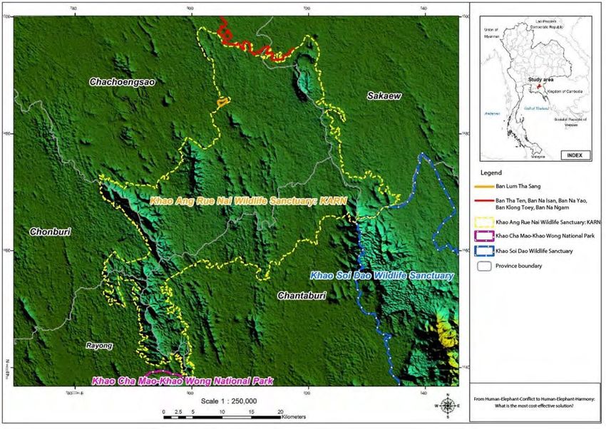
located in Chachoengsao province. KARN covers an area of 1,079 km2 across five provinces (Figure 6),
namely Chachoengsao (582 km2), Chonburi (61 km2), Rayong (53 km2), Chanthaburi (287 km2), and Sakaew
(47 km2) provinces in the East of Thailand. The total population in these five provinces was 3,718,213 in 2011,
with Chonburi having the highest (1,338,656 in 2011). The population in the four other provinces were not
so different in size in 2011 (Chachoengsao: 679,370; Rayong: 637,736; Chanthaburi: 516,855, and Sakaew:
545,596).
Figure 6. KARN wildlife sanctuary and the study areas
Source: Jarungrattanapong and Sajjanand (2011)
Note: The red and orange lines illustrate the study areas
(Ban LumTha Sang, Ban Tha Ten, Ban Na Isan, Ban Na Yao, Ban KlongToey, and Ban Na Ngam).
Payment for Ecosystem Services in Thailand and Lao PDR 16KARN is one of seven protected areas that have more than 100 elephants; the estimated elephant
population in KARN was approximately 217 and the crude density was 0.2 elephant per km2 in 2007
(Wanghonsa, Boonkird, and Boonkird 2008a). The KARN sanctuary is the watershed of Bang Pakong River
and Prasae River, which are major sources of surface water supply for residential areas, industries, and
agricultural production in the downstream area. KARN’s upper and middle area is mostly ridged plains,
which is moderately steep, and is the source of many brooks and waterways that lead to major rivers, such as
the Rabom Si Yad stream that runs to Bang Pakong River at Bangklao district in Chachoensao province, the
Lum Phra Peung Yai and Phra Sateung canals that run from Khao Sibhachan mountain to join Prajeenburi
River, the Tanod canal that runs to Tamai district in Chantaburi province, and the Prasae canal that runs
through Botong district in Chonburi province and into the sea at Rayong province.
The floristic nature of this area is mostly semi-evergreen forest, suited for wildlife habitats, such as
wild elephants, gaurs and bantengs, birds, insects, and reptiles. The area consists of Khao Chamao National
Park, Khao Kichakood National Park, Khao Soidao Wildlife Sanctuary and KARN Wildlife Sanctuary.
The government sectors in charge of both the inner and outer areas are mandated to preserve these fertile
forests, to rehabilitate and reforest, to improve people’s lives, and build collective consciousness in natural
resources preservation. KARN has high biodiversity; there are 132 kinds of mammals, such as black giant
squirrel, variable squirrel, crown gibbon, sambar, barking deer, wild elephant, gaur, and banteng, etc. A total
of 107 kinds of reptiles are also found in the area, along with 22 kinds of amphibians, 105 kinds of insects,
and 23 kinds of freshwater fish. KARN Wildlife Sanctuary is the nearest low and evergreen forest to Bangkok
and is also the transition zone between the Central and Northeast region’s ecological communities.
3.4.3 Changes in environmental quality
Impacts of HEC in KARN. Over the years, the ecosystems in KARN have been degraded and the
natural predators to the elephants, such as freshwater crocodiles and tigers, have become extinct. In the
absence of natural predators, the elephant population has been growing 9.83% per annum (Wanghongsa et
al. 2006). It has been estimated that only 36.63% of the sanctuary is suitable as elephant habitat
(Wonghongsa et al. 2008b). Therefore, because of the shortage of food and water, elephants often come out
of the sanctuary, resulting in KARN being one of the areas where the level of HEC is high in Thailand.
Jarungrattanapong and Sajjanand (2011) reported that the number of villages affected by crop raiding in
KARN was 162 in total across five provinces, affecting 48,058 households. The total compensation for crop
loss from crop raiding by elephants was approximately THB 1.5 million in 2009. However, this figure might
be underestimated because the number of households who registered for compensation in the study areas
was fewer than the actual affected households.
Current HEC mitigation measures. Some investments in habitat improvement activities have been
implemented to restore the degraded ecosystems (e.g., increasing mineral licks, food supplies, water
resources, and digging ditches), however, the scale of these measures have been insufficient due to the
limited availability of financial resources. This is why the PES approach was considered as a promising
solution. Presently, local villagers affected by crop raiding have applied traditional crop protection measures,
which are designed to chase the elephants away. Examples of deterrents include the use of firecrackers and
fire, placement of plastic-bag flags, elevated observation huts, and installment of electric fences (Figure 7).
In addition, the government has provided some measures to alleviate the HEC impacts—for example,
artificial water ponds, artificial mineral licks, pilot ditches, and road closures at nighttime from 9 pm to 5 am
(Figure 8), and compensation for crop damages. However, the current measures are still inadequate
compared to the growth rate of wild elephants.
Figure 7. Traditional mitigation measures by households
Source: Jarungrattanapong and Sajjanand (2011)
17 Economy and Environment Program for Southeast AsiaFigure 8. Mitigation measures by the government agencies
Source: Jarungrattanapong and Sajjanand (2011)
3.4.4 Proposed ecosystem restoration and HEC mitigation measures
The result of the consultations with wildlife experts and staff of the KARN wildlife sanctuary and of
the cost-benefit analysis done by Jarungrattanapong and Sajjanand (2011) recommended a number of
measures to mitigate HEC. The details of each activity are as follows:
1. Restoring sources of water supply within KARN. Presently, many of the natural water resources
within KARN have dried up. This is one of the reasons why wild elephants have to come out of
KARN. One of the proposals is therefore to increase the water supply available within the sanctuary
to reduce the need for elephants to exit the sanctuary in search of water in surrounding farmlands.
Cameras would be installed near these water resources to keep track of the number and timing of
visiting elephants and other wildlife animals that come to drink.
2. Creating artificial mineral licks in the sanctuary. Making artificial mineral licks as a source of food
for wildlife is another proposed measure. The mineral licks would be positioned at least 1 km from
the borders of the sanctuary and would be 2 km apart. At full scale, there should be 260 artificial
mineral licks, with the total boundary of KARN being 460 km.
3. Managing grasslands. Elephant’s habitat should not be simply dense forests but should have some
open grassland area. It is estimated that 70,000 rai (equivalent to 11,200 ha) 3 or around 11% of the
total area of KARN is covered with mainly bitter bushes and other fast-growing invasive species.
Under the PES pilot project, the target is to clear at least 40,000 rai. Since there is no knowledge of
how to get rid of bitter bushes permanently, during the short-term, the existing practice of burning
and digging will have to be employed. In the medium- and long-term, however, and in anticipation
that there will be sustainable support under the PES framework, basic research should be
undertaken on ways to control biologically and permanently the spread of bitter bushes and
invasive species within KARN.
4. Planting food for elephants within the sanctuary. To prevent elephants from exiting the sanctuary,
physical barriers may not be enough. Wild elephants raid the local communities not only for water
resources, but also for food, which are relatively more plentiful outside the sanctuary. Under the PES
pilot project, it is proposed that strips of local varieties of food be planted near the line of artificial
mineral licks. With water resources, mineral licks, and food supplies being more readily available,
there should be less incentive for elephants to come out of the sanctuary; this would, in principle,
be complimentary to putting up physical barriers as the last line of defense.
5. Contraception of female elephants to control birth rate of elephants. The maximum carrying
capacity of the sanctuary for elephants is approximately 500. The carrying capacity of the sanctuary
is estimated to be exceeded in the eighth year. Therefore, contraception of female elephants needs
to be introduced during the eighth year of the project, at which point the elephant population
would no longer be sustainable. However, contraception is effective for only 10 years; therefore, it
needs to be re-introduced at these regular intervals.
3
1 rai = 0.16 hectare
Payment for Ecosystem Services in Thailand and Lao PDR 18You can also read