Effects of Fire Severity and Topography on Soil Black Carbon Accumulation in Boreal Forest of Northeast China - MDPI
←
→
Page content transcription
If your browser does not render page correctly, please read the page content below
Article
Effects of Fire Severity and Topography on Soil Black
Carbon Accumulation in Boreal Forest of
Northeast China
Wentao Huang 1,2        ID
                             , Yuanman Hu 1 , Yu Chang 1, *, Miao Liu 1 , Yuehui Li 1 , Baihui Ren 1,2
and Sixue Shi 1,2
 1    CAS Key Laboratory of Forest Ecology and Management, Institute of Applied Ecology, Chinese Academy of
      Science, Shenyang 110016, China; huangwentao14@mails.ucas.ac.cn (W.H.); huym@iae.ac.cn (Y.H.);
      lium@iae.ac.cn (M.L.); liyh@iae.ac.cn (Y.L.); renbaihui1004@126.com (B.R.); ssx_ssx@126.com (S.S.)
 2    University of Chinese Academy of Science, Beijing 100049, China
 *    Correspondence: changyu@iae.ac.cn; Tel.: +86-024-8397-0350

 Received: 23 May 2018; Accepted: 3 July 2018; Published: 6 July 2018

 Abstract: Black carbon (BC) from incomplete combustion of biomass and fossil fuel is widespread in
 sediments and soils because of its high stability in nature and is considered an important component
 of the global carbon sink. However, knowledge of BC stocks and influencing factors in forest
 ecosystems is currently limited. We investigated soil BC contents in burned boreal forests of the
 Great Khingan Mountains, northeast China. We collected soil samples from 14 sites with different fire
 severities, slope positions and aspects. The samples were analyzed by the chemo-thermal oxidation
 method to obtain their BC concentrations. The BC concentrations of the studied soils ranged from
 0.03 to 36.91 mg C g−1 , with a mean of 1.44 ± 0.11 mg C g−1 . BC concentrations gradually decline
 with depth, and that was significantly less in the 20–30 cm layer compared to all shallower layers.
 Forests burned by moderate-severity fires had the highest soil BC, the shady aspect had higher soil
 BC than the sunny aspect. Our results provide some basic data for evaluating the soil BC sink in
 boreal forests, which is a useful amendment to current carbon budget and carbon cycle in boreal
 forest ecosystems.

 Keywords: black carbon; the Great Khingan Mountains; fire severity; topography; boreal forests

1. Introduction
     Black carbon (BC), alternatively termed pyrogenic carbon, char, charcoal, or biochar depending
on different points of focus [1–3], is the residue production from incomplete combustion of biomass
and fossil fuel [4–6]. It can resist a high level of degradation and be stored for centuries to millennia in
the natural environment [7]. BC is widespread in sediments and soils because of its refractory nature
and the common occurrence of combustion [8–10]. Some studies have shown that much of BC is stored
in boreal forest soils [11–14]. In addition, fire frequency will increase in boreal forest ecosystems with
the climatic warming [15] and this trend could be further enhanced by the end of this century [16].
Therefore, the production of BC from wildfires in boreal forests will probably increase, resulting in
more BC being stored in soils. Although the BC is considered an important carbon sink and may play
an important role in alleviating climate change [17,18], it is largely neglected in current studies in
carbon cycling and carbon budget of forest ecosystems. Therefore, estimation of the BC stock and
determination of its influencing factors are crucial for understanding carbon cycling and carbon stocks
of boreal forest ecosystems under future climate change. Researchers have demonstrated the need for
taking into account soil BC in the inventories of global carbon pools [19,20].

Forests 2018, 9, 408; doi:10.3390/f9070408                                         www.mdpi.com/journal/forests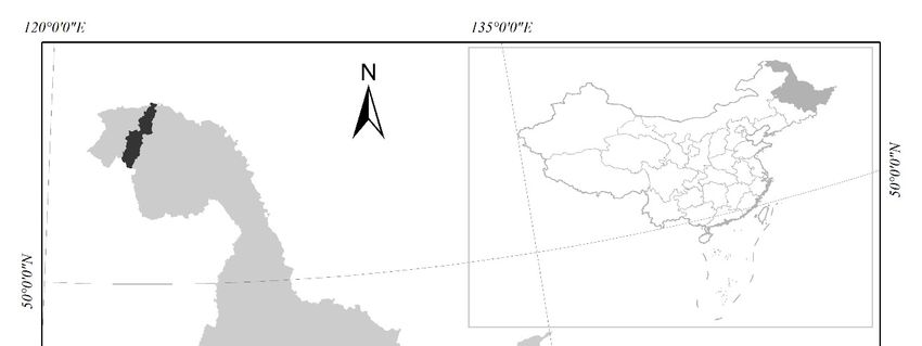
Forests 2018, 9, 408                                                                                  2 of 13

      There are few quantitative reports of BC stocks in boreal forest soils, particularly in boreal
forests of China [21]. Soil BC was 0.2 (± 0.1) kg C m−2 in Quebec black spruce forests [13] and
0.6 ± 0.3 kg C m−2 in black spruce forest floors from eastern Canada [22] and 0.072 kg C m−2 on the
forest floor of Siberian Scots pine forests [23]. Average BC in surface mineral soils of black spruce forests
at different landscape positions in Alaska, USA was 0.34 ± 0.09 kg C m−2 [24] and 0.02–3.40 kg C·m−2
in the forest tundra ecotone in Northern Siberia [25]. These results show large differences, which could
be attributed to different methods of sampling and measuring [26,27]. Many factors may influence
soil BC [28] and forest fire severity is a major contributing factor to soil BC retention. For example,
a previous study showed that less BC stocked in the forest floor was burned by high-severity fires
than by low-to-moderate severity fires [29]. In contrast, a previous study reported that BC tended to
increase in areas subjected to low-severity burning [30]. There has been no agreement on the influences
of forest fire severity on soil black carbon stocks in recent years. In addition, topographic condition
may be another crucial control on soil BC stocks. Some reports have indicated that south-facing aspects
had more BC than north-facing aspects [24,31] and BC was highest at hill bottoms [32]. However, it
remains unclear how fire severities and topography affect soil BC stocks in boreal forests [33].
      The area of boreal forests of the world is nearly 16.6 million km2 , comprising about one third of the
world’s forest cover [34]. About 5–20 million ha of boreal forests are burnt annually [35]. Boreal forests
are subjected to frequent fire disturbances resulting in the accumulation of BC in forest soils, which
could be a potential carbon sink given the extensive distribution of boreal forests [5]. Estimation of BC
stocks is crucial for evaluating the BC sink to further inform current forest carbon budget and carbon
cycling. Therefore, investigation of BC storage in boreal forest soils may thus help to understand the
role of boreal forests in global carbon cycles and soil carbon stocks.
      The Great Khingan Range is a well-known mountain range in northeast China, bordering the
Russian Far East in the north (49◦ 22’57” N, 123◦ 09’24” E) [36,37]. The area has a large expanse of
hills with an elevation of 1200–1300 m a.s.l., and it belongs to the cold temperate zone continental
monsoon climate. There are 16.5 million ha of boreal forests in the range and the forest coverage rate
is 76.4% [38]. The forest fire regime in the Great Khingan Range is characterized by low frequency
and high-severity fire [39]. On 6 May 1987, a catastrophic fire occurred, which lasted almost a month.
The fire covered about 10,000 km2 , of which 6500 km2 was forestry [40], providing an ideal location for
estimating BC stocks and exploring the factors affecting BC storage.
      Therefore, in this paper, taking Tuqiang Forest Bureau on the eastern slopes of Great Khingan
Ranges, we aim to (1) investigate BC contents in boreal forest soils in the Great Khingan Range, and (2)
elucidate the effect of fire severity and different topography on BC content. We initially hypothesized
that (1) the soil BC content is higher on sunny slopes than shady slopes as sunny slopes are subjected
to frequent fires; and that (2) the soil BC content is high in forests burned by moderate-severity fires
owing to low burning efficiency at low-severity and complete burning at high-severity. We measured
the concentration of BC in boreal forest soils and assessed the effects of different wildfire severities and
topography on BC storage in the Great Khingan Mountains.

2. Materials and Methods

2.1. Study Area
      The study was conducted in the Tuqiang Forest Bureau (from 52◦ 15’55” to 53◦ 33’40” N,
and 122◦ 18’05” to 123◦ 29’00” E) with an area of ~4000 km2 , located in Mohe county, the northernmost
county of China (Figure 1). The study area has a cold, continental climate, with an average annual
temperature of −5 ◦ C. Monthly mean temperature ranges from −47.2 ◦ C in January to 31.4 ◦ C in July.
The average annual precipitation is 432 mm, with great inter-annual variations, and 75% of the rainfall
occurs between June and August. Uplands and small hills characterize this region, though it possesses
a relatively smooth topography. Slopes are generally less than 15◦ , the maximum slope is less than 45◦ .
Hills undulate throughout this area, and mountain ranges mostly run in north and south directions.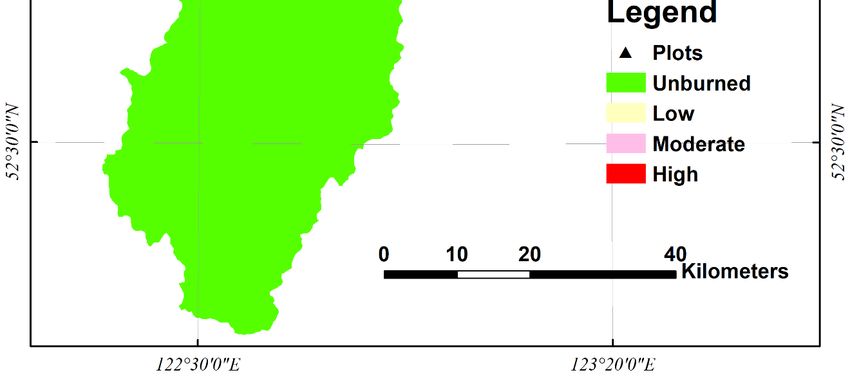
Forests 2018, 9, x FOR PEER REVIEW 3 of 14
Forests 2018, 9, 408 3 of 13
less than 45°. Hills undulate throughout this area, and mountain ranges mostly run in north and
south directions.
Elevations Elevations
range from 270 torange
1210 m from 270with
a.s.l., to 1210 m a.s.l.,
the mean with theofmean
elevation 500 m.elevation of 500 m. Brown
Brown coniferous forest
coniferous forest soil is representative in the Bureau. Vegetation is dominated
soil is representative in the Bureau. Vegetation is dominated by larch (Larix gmelinii Rupr.) by larch (Larix gmelinii
forests.
Rupr.)birch
White forests. White
(Betula birch (Betula
platyphylla platyphylla
var. japonica) var.
is the japonica)
major is the major
broad-leaved broad-leaved
species species
in the region. in the
In addition
region.
to larch In
andaddition to larch
white birch, andspecies
the tree white birch,
include the tree species
Mongolian include
Scotch Pine Mongolian Scotch
(Pinus sylvestris var.Pine (Pinus
mongolica),
sylvestris var. mongolica), spruce (Picea koraiensis Nakai), aspen-D (Poulus davidiana Dode),
spruce (Picea koraiensis Nakai), aspen-D (Poulus davidiana Dode), black birch (Betula davurica Pall.), black birch
(Betula davurica
aspen-S (PopulusPall.), aspen-S
suaveolens (Populus
Fisch), suaveolens
and willow Fisch),
(Salix and willow
matsudana Koidz.)(Salix
[41].matsudana Koidz.) [41].
On 6 May 1987, a catastrophic forest fire of 1.33 × 10⁴
4 km2 took place in the Great Khingan
2
On 6 May 1987, a catastrophic forest fire of 1.33 × 10 km took place in the Great Khingan
Mountains. The
Mountains. burned areaarea covered
covered 2.312.31 ×
× 10
103 kmkm2in inthe
theTuqiang
Tuqiang Forest
Forest Bureau,
Bureau, and
and the severely
3 2
The burned the severely
burned area covered roughly 900 km . The conflagration destroyed an extensive amount vegetation,
2
burned area covered roughly 900 km2 . The conflagration destroyed an extensive amount vegetation,
during which a considerable amount of BC was produced.
during which a considerable amount of BC was produced.
Figure 1. Location of the Tuqiang Forest Bureau study site in Heilongjiang province, China.
Figure 1. Location of the Tuqiang Forest Bureau study site in Heilongjiang province, China.
2.2. Sampling
2.2. Sampling
Samples
Samples werewere collected
collected from
from 29 29 July
July to
to 33 August
August 2016.
2016. Fourteen sites were
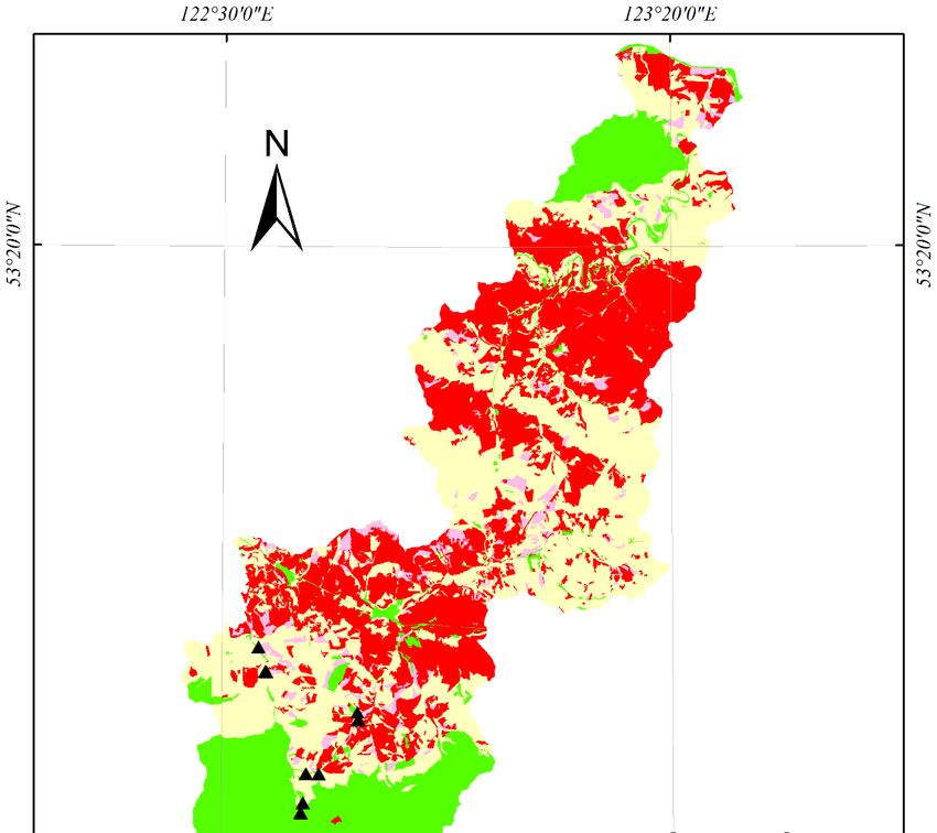
Fourteen sites were chosen
chosen across
across thethe
burned areas with different severities of the Tuqiang Forest Bureau in 1987 (Figure
burned areas with different severities of the Tuqiang Forest Bureau in 1987 (Figure 2). At each site, 2). At each site,
three
three plots (20 ×
plots (20 20 m)
× 20 m) were
were established,
established, ~20~20 m m apart
apart from
from each
each other.
other. The
The location
location ofof each
each plot
plot was
was
determined
determined using
usingaaportable
portable global
globalpositioning
positioning system. We We
system. recorded the severity
recorded of forest
the severity of fires,
forestaspect,
fires,
slope position,
aspect, altitude,altitude,
slope position, and forest andtype for each
forest typeplot
for (Table
each plot1). For each1).plot,
(Table Forwe randomly
each plot, wechose three
randomly
sub-plots.
chose threeAt each sub-plot,
sub-plots. At each four samples
sub-plot, each
four at different
samples each atdepths (0–5,
different 5–10, (0–5,
depths 10–205–10,
and 10–20
20–30 andcm)
were collected with cutting rings in pits. On our study sites, wildfires happened
20–30 cm) were collected with cutting rings in pits. On our study sites, wildfires happened nearly 30 nearly 30 years ago,
so thatago,
years there
sowere
that no apparently
there were no organic
apparentlylayers. Actually,
organic theActually,
layers. organic layer is part of
the organic our is
layer top soiloflayer
part our
(0–5 cm).layer
top soil Each(0–5
sample
cm).was stored
Each samplein anwas
aluminum
stored in box,
an and subsequently
aluminum box, andbrought to the laboratory
subsequently broughtfor to
analysis. Prior to further processing all visible roots and rocks were removed
the laboratory for analysis. Prior to further processing all visible roots and rocks were removed manually.
manually.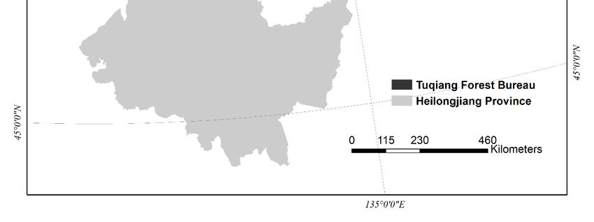
Forests 2018, 9, 408                                                                                                                                     4 of 13

                                                        Table 1. Details of the selected sampling sites.

                Site   Number of Samples       Coordinate               Fire Severity       Slope Position   Aspect         Dominant Specie
                  1           32           122.7514 E, 52.8045 N           High                 Lower        Shady         Larix gmelinii Rupr.
                  2           35           122.7526 E, 52.8043 N           High                 Lower        Shady    Betula platyphylla var. japonica
                  3           36           122.5676 E, 52.8860 N         Moderate                Flat         Flat             Larix gmelinii
                  4           28           122.5828 E, 52.8577 N           High                 Upper        Sunny       Populus davidiana Dode
                  5           26           122.5815 E, 52.8573 N           Low                  Middle       Sunny    Pinus sylvestris var. mongolica.
                  6           33           122.5808 E, 52.8579 N           Low                  Lower        Sunny    Pinus sylvestris var. mongolica.
                  7           35           122.6474 E, 52.6998 N         Unburned               Middle       Shady             Larix gmelinii
                  8           35           122.6466 E, 52.7010 N         Unburned               Bottom       Shady             Larix gmelinii
                  9           36           122.6513 E, 52.7115 N         Unburned               Middle       Sunny    Pinus sylvestris var. mongolica.
                 10           36           122.6514 E, 52.7111 N         Unburned               Bottom       Sunny    Pinus sylvestris var. mongolica.
                 11           36           122.6554 E, 52.7437 N         Moderate               Lower        Shady             Larix gmelinii
                 12           33           122.6804 E, 52.7436 N           Low                  Upper        Shady    Pinus sylvestris var. mongolica
                 13           36           122.6803 E, 52.7435 N           Low                  Middle       Shady    Pinus sylvestris var. mongolica
                 14           36           122.6797 E, 52.7436 N           Low                  Lower        Shady    Pinus sylvestris var. mongolica
Forests 2018,
Forests 9, 408
2018, 9, x FOR PEER REVIEW 5 of5 14
of 13
Figure 2. Distribution of forest fire severity and locations of sample plots.
Figure 2. Distribution of forest fire severity and locations of sample plots.
2.3. Measurements of Bulk Density and Determination of BC
2.3. Measurements of Bulk Density and Determination of BC
Bulk density was determined by oven drying at 105 °C for 12 h. Soil samples were ground and
Bulk density was determined by oven drying at 105 ◦ C for 12 h. Soil samples were ground and
subsequently sieved through 100 mesh (diameter: 0.150 mm). To determine BC concentrations in the
subsequently sieved through 100 mesh (diameter: 0.150 mm). To determine BC concentrations in the
samples, we used the chemo-thermal oxidation method (CTO-375). This method considers
samples, we used the chemo-thermal oxidation method (CTO-375). This method considers differences
differences in chemical and thermal stability between BC and other forms of carbon, and thus only
in chemical
measures and thermal
the most stabilityfraction
refractory betweenof BC
BCandandother forms
has the of carbon,
lowest and thus
bias [42–44]. Firstonly measures the
non-pyrogenic
most
organic carbon was removed by thermal oxidation of 1.00 g soil at 375 °C for 16 h undercarbon
refractory fraction of BC and has the lowest bias [42–44]. First non-pyrogenic organic was
air flow
removed by thermal oxidation of 1.00 g soil ◦
conditions. To remove inorganic carbon, theat 375 Csamples
residual for 16 hwere
under air flow conditions.
transferred To remove
into centrifuge tubes
inorganic carbon, the residual samples were transferred into centrifuge tubes and soaked
and soaked in 1 mol L HCl (10 mL) for 1 h. After decarbonation, we added 50% NaOH to adjust the
−1 in 1 mol L−1
HClpH(10tomL) for avoid
7. To 1 h. After decarbonation,
possible weCl
causticity of added 50%elemental
− on the NaOH to analyzer,
adjust theafter
pH tocentrifugation
7. To avoid possible
and
causticity of Cl − on the elemental analyzer, after centrifugation
decanting the supernatant, 10 mL deionized water was addedand decanting
to wash the supernatant,
the residues 10 mL
and repeated
deionized water
three times was
until Cl− added to wash
of residues the residues
was removed. Theand repeated
residues werethree
driedtimes
at 100until Cl−residual
°C. The of residues
carbonwas
removed. The residues were dried at 100 ◦ C. The residual carbon after these treatments was then
termed as BC and quantified using an elemental analyzer (Vario MACRO Cube, Elementar, Hanau,Forests 2018, 9, 408 6 of 13
Forests 2018, 9, x FOR PEER REVIEW 6 of 14
Germany)
after theseat the Agricultural
treatments Product
was then termedSafety
as BCand Environmental
and Quality
quantified using Testing Center
an elemental analyzer of (Vario
Institute
of MACRO
Applied Cube,
Ecology, Chinese Academy of Sciences. References of known carbon
Elementar, Hanau, Germany) at the Agricultural Product Safety and Environmental ( D -Phenylalanine,
C9Quality
H11 NO2Testing
, 99%) concentrations wereofused
Center of Institute for calibration.
Applied Soil BCAcademy
Ecology, Chinese stocks were calculated
of Sciences. using theofBC
References
concentration
known carbon and(Dbulk density data.
-Phenylalanine, C9H11NO2, 99%) concentrations were used for calibration. Soil BC
stocks were calculated using the BC concentration and bulk density data.
2.4. Statistical Analysis
2.4. Statistical Analysis
Statistical analyses were performed with the software IBM SPSS Statistics 24. We examined
whether Statistical
there was analyses were difference
a significant performedofwith soil the softwareamong
BC content IBM SPSS Statistics
various 24. Wefire
soil depths, examined
severities,
whether there was a significant difference of soil BC content among various soil depths,
aspects, slope positions, and by single factor analysis of variance or an independent-samples t-test. fire severities,
Theaspects,
tests ofslope positions,
normality andwere
of data by single factorusing
assessed analysis of variance or test
the Shapiro-Wilk an independent-samples
and the equality of variancest-test.
wasThe tests of normality
assessed of data were
using Levene’s assessed usingtest.
homoscedasticity the Shapiro-Wilk
In the casestest and the
where equality of
differences invariances
arithmetic
was assessed using Levene’s homoscedasticity test. In the cases where differences
mean BC content among classes were statistically significant and variances of BC content for in arithmetic mean
those
BC content among classes were statistically significant and variances of BC content
classes were equal, the post-hoc Duncan’s multiple range test was performed to identify classes with for those classes
were equal,different
significantly the post-hoc
means. Duncan’s multiple
In the cases range test
of unequal was performed
variance, the post-hocto identify
Tamhane’s classes with
T2 test was
significantly different means. In the cases of unequal variance, the post-hoc Tamhane’s T2 test was
performed instead of Duncan’s. The level of significance used for all the tests was 5% (i.e., α = 0.05).
performed instead of Duncan’s. The level of significance used for all the tests was 5% (i.e., α = 0.05).
We used a general linear model to test potential interactions between fire severity and topographic
We used a general linear model to test potential interactions between fire severity and topographic
features. More information about statistical analysis can be found in the Supplement 1.
features. More information about statistical analysis can be found in the Supplement 1.
3. Results
3. Results
3.1. Soil BC Concentration at Different Depths
3.1. Soil BC Concentration at Different Depths
The BC concentration in different layers of forest soils of the Great Khingan Mountains ranged
The BC concentration in different layers of forest soils of the Great Khingan Mountains ranged
from 0.03 to 36.91 mg C g−−11 , with a mean of 1.44 ± 0.11 mg C−1 g−1 . The maximum was observed in
from 0.03 to 36.91 mg C g , with a mean of 1.44 ± 0.11 mg C g . The maximum was observed in the
the 0–5 cm layer and the minimum in the 20–30 cm layer. Soil BC concentration decreased with depth
0–5 cm layer and the minimum in the 20–30 cm layer. Soil BC concentration decreased with depth
(Figure 3). In the 0–5 cm layer, the mean value of soil BC concentration was 2.38 ± 0.37 mg C −1 g−1 , the
(Figure 3). In the 0–5 cm layer, the mean value of soil BC concentration was 2.38 ± 0.37 mg C g , the
highest
highestof of
thethestudied
studiedsoil
soildepth,
depth,followed
followedby 1.44 ±
by1.44 mgCCgg−1−at
0.14 mg
± 0.14
1 at 5–10 cm, 1.02 ± 0.08 mg C g−1
5–10 cm, 1.02 ± 0.08 mg C g−1 at
at 10–20
10–20 cmcm layer,
layer,and 0.76± ±0.03
and0.76 0.03 mg C g − 1 at 20–30 cm soil depth. Significant differences
mg C g at 20–30 cm soil depth. Significant
−1 differences in BC in
BCconcentration
concentration were observed between layers; soil BC concentration at 0–5
were observed between layers; soil BC concentration at 0–5 cm soil depth was cm soil depth was
significantly
significantlyhigher
higherthan
thanthat
thatatat10–20
10–20cmcm(p
(pForests 2018, 9, 408 7 of 13
Forests 2018, 9, x FOR PEER REVIEW 7 of 14
3.2.
3.2.Soil
SoilBC
BCConcentration
Concentration among
among Different
Different Topography and Various
Topography and Various Fire
Fire Severities
Severities
At
At0–5,
0–5, 5–10, and 10–20
5–10, and 10–20cmcmsoil
soildepth,
depth, the
the shady
shady aspect
aspect hadhad a higher
a higher BC concentration
BC concentration than
than the
the sunny aspect and flat terrain, whereas at 20–30 cm soil depth, the flat terrain had
sunny aspect and flat terrain, whereas at 20–30 cm soil depth, the flat terrain had the highest BC the highest
BC concentration
concentration (Figure
(Figure 4a). 4a).
The The soilconcentration
soil BC BC concentration was significantly
was significantly higher higher (p on
(p < 0.05) < 0.05) on the
the shady
shady slope than on the sunny slope at 0–5 and 5–10 cm soil depth, whereas there
slope than on the sunny slope at 0–5 and 5–10 cm soil depth, whereas there was no significant was no significant
difference
difference(p(p>>0.05)
0.05) in
in soil
soil BC
BC concentration
concentration on on the
the shady
shadyaspect
aspectand
andthe
thesunny
sunnyterrain
terrainatat10–20
10–20and
and
20–30
20–30cmcmsoil
soildepth.
depth.
Figure 4. Soil BC concentrations on different aspects (a), on different slope positions (b) and of various
Figure 4. Soil BC concentrations on different aspects (a), on different slope positions (b) and of various
fire severities (c) in the Great Khingan Mountains. Error bars indicate standard errors.
fire severities (c) in the Great Khingan Mountains. Error bars indicate standard errors.
With regard to slope position, we found that soil BC concentration was the highest on toe slopes,
Withatregard
except 0–5 cm to slope
depthposition,
on the we found
lower that and
slopes soil BC concentration
20–30 cm depth was on theflat highest on toe
positions. Soilslopes,
BC
except at 0–5 cmatdepth
concentration each on
soilthe lower
depth wasslopes andon
lowest 20–30 cm depth
the upper on flat
slopes positions.
at each depth.Soil BC concentration
Statistical analysis
atshowed
each soil depth
that therewas waslowest on the upper
no significant slopes
difference (p at each in
> 0.05) depth. Statistical
soil BC analysis
concentration onshowed
all slopesthat there
at any
was no significant
depth (Figure 4b). difference (p > 0.05) in soil BC concentration on all slopes at any depth (Figure 4b).
WeWefound
foundthat
thatforest
forestburned
burned byby moderate-severity
moderate-severity firesfires had
hadthe
thehighest
highestsoil
soilBCBCconcentration
concentration atat
each
eachsoil
soildepth.
depth.The
Thelowest
lowestsoil
soilBC
BCconcentration
concentrationoccurred
occurredininforests burned
forests burned bybylow-severity
low-severity fires at at
fires 0–5
0–55–10
and and cm5–10
soilcm soil depth,
depth, and byand by high-severity
high-severity fires atofdepth
fires at depth 10–20ofand10–20
20–30andcm20–30 cm soil
soil depth depth
(Figure 4c).
(Figure 4c).
Statistical Statistical
analysis showedanalysis showed
that, for each ofthat, for each
the four of there
layers, the four
was layers, there was
no significant no significant
difference (p > 0.05)Forests 2018, 9, 408 8 of 13
Forests 2018, 9, x FOR PEER REVIEW 8 of 14
in soil BC concentration of plots burned by different fire severities except at 20–30 cm soil depth,
difference (p > 0.05) in soil BC concentration of plots burned by different fire severities except at 20–
where
30 cmsoil BCdepth,
soil concentration in forests
where soil burned by high-severity
BC concentration fires wasby
in forests burned significantly lower
high-severity (pForests 2018, 9, 408 9 of 13
4. Discussion
4.1. Soil Content in Forests of the Great Khingan Mountains
Our findings are the first estimation of soil BC in the Great Khingan Mountains as affected
by fire severity and topography. Our results indicated that BC concentration ranged from
0.03 to 36.91 mg C g−1 , with mean of 1.44 ± 0.11 mg C g−1 , a 10th percentile of 0.53 mg C g−1 , and 90th
percentile of 2.23 mg C g−1 . Our results are comparable to previous reports, such as 0.57–7.15 mg C g−1
from Australian soils [45]; 0.27–5.62 mg C g−1 from Australian agricultural, pastoral, bushland,
and parkland soil [9]; and 0.28–2.7 mg C g−1 in soils around France [44]. Moreover, the soil BC
concentration in our study area was much lower than that in top peat soils in Changbai Mountains,
China ranging from 0.25 to 50.7 mg C g−1 with a mean of 17.2 mg C g−1 [46] and in a swamp in
Australia, which ranged from 1 to 32 mg C g−1 [47]. This is because peat soils typically exhibit a
lack of oxygen, which is unfavorable for degradation of BC [46]. In contrast, we measured soil BC
concentration by the CTO-375 method, which could only quantify highly condensed BC. Therefore, the
soil BC concentration was substantially below that measured by the dichromate oxidation method [46]
and benzene polycarboxylic acids method [42,47].
Soil BC concentration in our study sites decreased with depth. This is similar to the findings in
the Amazon basin forest soils [48] and in the Amazon seasonal forest soils [19]. This similarity may be
because there are few disturbances along the direction of gravity in the Great Khingan Mountains and
BC degrade slowly in soils [49]. Thus, the pyrogenic carbon/total organic carbon ratio in the Amazon
basin forest soils increases with depth [19]. This indicates that BC will degrade distinctly slower in
deep soils compared with other types of organic carbon. In addition, we only collected soil samples up
to 0–30 cm depth rather than 0–100 m depth or more [19,48,50]. This was because the thickness of soils
in our plots was nearly 30 cm below which was only hard rocks. Nonetheless, we found that soil BC
was mainly distributed in top soils (0–20 cm), accounting for 80.2%, and only a small portion of BC
was therefore present within deeper soils (20–30 cm). On our study sites, the top soil layer (0–5 cm)
includes the organic layer, this is in line with a previous report that most BC stores in the organic
layer and deep mineral soil contains very little BC in the boreal forests [23]. Hence, the soil BC data
we obtained could be part of database that used to estimate the total BC sink in the Great Khingan
Mountains and other regions that contain a similar boreal forest condition.
4.2. Factors Affecting Soil BC Distribution
Forest fire severity coupled with topographic conditions may impact the formation and content of
BC in soils [24,29]. We found soil BC stocks on flat and shady slopes was higher than those on sunny
slopes. This result rejects our first hypothesis that the soil BC stocks are higher on sunny slopes than
that on shady ones. Our results are consistent with a previous report that more soil BC on north-facing
aspects was founded than on south-facing aspects in burned boreal forests in Alaska [31]. This is
understandable as flat and shady slopes are generally more humid than sunny slopes. Once forests on
shady slopes are burned, the humid environmental conditions are more conductive to the incomplete
combustion of forest fuels, thus increasing BC [31,51]. In addition, the soil temperature of flat and shady
slopes is lower than that of sunny slopes because of the lower amount of incoming solar radiation.
Warmer conditions on sunny slopes are suitable for the growth and reproduction of microbes that can
decompose BC [52], resulting in the degradation of BC. Our results showed that flat and shady slopes
had similar amounts of soil BC stocks. This might be related to the increased amount of available fuels
and warmer conditions on flat plots than in shady plots.
Our results also showed that more soil BC was generated by moderate-severity fires. This result
supports our second hypothesis that the soil BC content is high in forests burned by moderate-severity
fires. Our result supports the finding that the pyrogenic carbon in soils was higher after moderate
forest fire disturbances in California, USA [29]. This is because fuel is exposed to high temperatures
during high-severity fires, resulting in more complete combustion than in moderate-severity firesForests 2018, 9, 408 10 of 13
and thus reduced production of BC [23,53]. In contrast, less fuel is consumed during low-severity
fires [54] leading to some BC remaining in soils. However, we found that the unburned plots had more
(not significantly) soil BC than both low- and high-severity fire plots. The soil BC in unburned plots
may be caused by historical forest fires. Repeated fires could consume a portion of soil BC previously
accumulated [14]. In addition, wildfires may result in soil erosion which could deliver soil BC to
rivers [55] and to the mountain hill foot [56].
Besides aspects and fire severities, slope position may also affect soil BC contents, for example, a
greater accumulation of organic material on lower slope positions [22,31]. Our results suggest that soil
BC content on lower slopes is higher than on middle and upper slopes. Our results are inconsistent
with previous findings [22,24]. This might be attributed to runoff and soil erosion [57] on post-fire
terrain, which carry soil BC to lower places. The runoff and soil erosion are common following heavy
rainfall events after burning of steep terrain [57], resulting in the accumulation of BC on lower slopes.
However, the runoff and soil erosion processes are highly complicated and understanding of the
influence of soil erosion on the movement of soil BC downwards remains quite limited and requires
further exploration [57,58].
4.3. Other Possible Factors Affecting Soil BC Distribution and Prospects
Although we found that fire severity did significantly affect BC stocks and topography could affect
BC stocks as well, our statistical analysis indicates that there was no significant difference between the
effects of fire severity on BC stocks and that of topography. However, this result was based on only a
few sites. Actually, fires of high severity tend to occur more often on eastern and southern aspects than
that on other aspects in Northeast China [59]. The interaction between topographic features and fire
severity might affects soil BC stocks in boreal forests, which should be taken into account in further
studies. Regarding vegetation types, our findings showed that no correlation between dominant tree
species and soil BC content. However, fires of high severity are more likely burn within coniferous
forests [59,60], and thus vegetation species may affect soil BC stocks. Therefore, further studies needed
to design to determine the effects of vegetations on soil BC stocks and the interaction between fire
severity and vegetation types. In addition, other possible factors such as wind, soil types, and water
erosion require further study in the future.
5. Conclusions
Soil BC was mainly distributed at 0–20 cm, accounting for 80.2% of total BC. Soil BC contents were
affected by fire severity, slope position, and aspect, leading to heterogeneous patterns. Forests burned
by moderate-severity fires had the highest soil BC, probably because of the increased production of BC
in moderate wildfires. The flat and shady aspect had higher soil BC than the sunny aspect probably
because of improper conditions for BC production and accumulation; and soil BC on lower slopes was
higher than that on middle and upper slopes. Therefore, boreal forests burned with moderate-severity
wildfires on lower shady slopes are most conducive to soil BC accumulation in the Great Khingan
Mountains. Our results could provide some basic data for evaluating the soil black carbon sink in
boreal forests, which is a useful amendment to the current carbon budget and carbon cycle in boreal
forest ecosystems.
Supplementary Materials: The following are available online at http://www.mdpi.com/1999-4907/9/7/408/s1.
Author Contributions: Methodology, W.H.; Software, W.H. and B.R.; Formal Analysis, Y.C. and W.H.;
Investigation, Y.C., W.H., Y.L. and S.S.; Resources, M.L.; Writing—Original Draft Preparation, W.H.;
Writing—Review & Editing, Y.C., Y.H.; Supervision, Y.C., Y.H.; Project Administration, Y.C. and M.L.; Funding
Acquisition, Y.C.
Funding: This research was funded by National Natural Science Foundation of China (grant number: 31470516).
Acknowledgments: The authors acknowledge the assistance of the Test Center of Agricultural Product and
Environmental Quality of Institute of Applied Ecology, Chinese Academy of Sciences. We thank Zaiping Xiong,
Long Chen, Zhen Li, Changmeng Zhang, Hongxin Zhang, Changhe Hu and Baoqi Zhang for helping to collectForests 2018, 9, 408 11 of 13
samples and to the field guide. We thank Alex Boon, from Liwen Bianji, Edanz Editing China (www.liwenbianji.
cn/ac), for editing the English text of a draft of this manuscript.
Conflicts of Interest: The authors declare no conflict of interest.
References
1. Bird, M.I.; Ascough, P.L. Isotopes in pyrogenic carbon: A review. Org. Geochem. 2012, 42, 1529–1539.
[CrossRef]
2. Zimmermann, M.; Bird, M.I.; Wurster, C.; Saiz, G.; Goodrick, I.; Barta, J.; Capek, P.; Santruckova, H.;
Smernik, R. Rapid degradation of pyrogenic carbon. Glob. Chang. Biol. 2012, 18, 3306–3316. [CrossRef]
3. Chiapini, M.; Schellekens, J.; Calegari, M.R.; de Almeida, J.A.; Buurman, P.; de Camargo, P.B.; Vidal-Torrado, P.
Formation of black carbon rich ‘sombric’ horizons in the subsoil—A case study from subtropical Brazil.
Geoderma 2018, 314, 232–244. [CrossRef]
4. Goldberg, E.D. Black Carbon in the Environment: Properties and Distribution; John Wiley & Sons Inc.: Hoboken,
NJ, USA, 1985; p. 798.
5. Bird, M.I.; Wynn, J.G.; Saiz, G.; Wurster, C.M.; McBeath, A. The Pyrogenic Carbon Cycle. Annu. Rev. Earth
Planet. Sci. 2015, 43, 273–298. [CrossRef]
6. Mastrolonardo, G.; Hudspith, V.A.; Francioso, O.; Rumpel, C.; Montecchio, D.; Doerr, S.H.; Certini, G.
Size fractionation as a tool for separating charcoal of different fuel source and recalcitrance in the wildfire
ash layer. Sci. Total Environ. 2017, 595, 461–471. [CrossRef] [PubMed]
7. Singh, N.; Abiven, S.; Torn, M.S.; Schmidt, M.W.I. Fire–derived organic carbon in soil turns over on a
centennial scale. Biogeosciences 2012, 9, 2847–2857. [CrossRef]
8. Jauss, V.; Sullivan, P.J.; Sanderman, J.; Smith, D.B.; Lehmann, J. Pyrogenic carbon distribution in mineral
topsoils of the northeastern United States. Geoderma 2017, 296, 69–78. [CrossRef]
9. Qi, F.; Naidu, R.; Bolan, N.S.; Dong, Z.; Yan, Y.; Lamb, D.; Bucheli, T.D.; Choppala, G.; Duan, L.; Semple, K.T.
Pyrogenic carbon in Australian soils. Sci. Total Environ. 2017, 586, 849–857. [CrossRef] [PubMed]
10. Reisser, M.; Purves, R.S.; Schmidt, M.W.I.; Abiven, S. Pyrogenic Carbon in Soils: A Literature–Based
Inventory and a Global Estimation of Its Content in Soil Organic Carbon and Stocks. Front. Earth Sci. 2016, 4.
[CrossRef]
11. Ohlson, M.; Dahlberg, B.; Okland, T.; Brown, K.J.; Halvorsen, R. The charcoal carbon pool in boreal forest
soils. Nat. Geosci. 2009, 2, 692–695. [CrossRef]
12. Hart, S.; Luckai, N. Charcoal function and management in boreal ecosystems. J. Appl. Ecol. 2013, 50,
1197–1206. [CrossRef]
13. Soucémarianadin, L.N.; Quideau, S.A.; MacKenzie, M.D. Pyrogenic carbon stocks and storage mechanisms
in podzolic soils of fire–affected Quebec black spruce forests. Geoderma 2014, 217–218, 118–128. [CrossRef]
14. Kasin, I.; Ellingsen, V.M.; Asplund, J.; Ohlson, M. Spatial and temporal dynamics of the soil charcoal pool in
relation to fire history in a boreal forest landscape. Can. J. For. Res. 2016, 47, 28–35. [CrossRef]
15. Kelly, R.; Chipman, M.L.; Higuera, P.E.; Stefanova, I.; Brubaker, L.B.; Hu, F.S. Recent burning of boreal
forests exceeds fire regime limits of the past 10,000 years. Proc. Natl. Acad. Sci. USA 2013, 110, 13055–13060.
[CrossRef] [PubMed]
16. Heon, J.; Arseneault, D.; Parisien, M.A. Resistance of the boreal forest to high burn rates. Proc. Natl. Acad.
Sci. USA 2014, 111, 13888–13893. [CrossRef] [PubMed]
17. Santin, C.; Doerr, S.H.; Preston, C.M.; Gonzalez–Rodriguez, G. Pyrogenic organic matter production from
wildfires: A missing sink in the global carbon cycle. Glob. Chang. Biol. 2015, 21, 1621–1633. [CrossRef]
[PubMed]
18. Landry, J.-S.; Matthews, H.D. The global pyrogenic carbon cycle and its impact on the level of atmospheric
CO2 over past and future centuries. Glob. Chang. Biol. 2017, 23, 3205–3218. [CrossRef] [PubMed]
19. Turcios, M.M.; Jaramillo, M.M.; do Vale, J.F., Jr.; Fearnside, P.M.; Barbosa, R.I. Soil charcoal as long–term
pyrogenic carbon storage in Amazonian seasonal forests. Glob. Chang. Biol. 2016, 22, 190–197. [CrossRef]
[PubMed]
20. Mastrolonardo, G.; Francioso, O.; Certini, G. Relic charcoal hearth soils: A neglected carbon reservoir. Case
study at Marsiliana forest, Central Italy. Geoderma 2018, 315, 88–95. [CrossRef]Forests 2018, 9, 408 12 of 13
21. Preston, C.M.; Schmidt, M.W.I. Black (pyrogenic) carbon: a synthesis of current knowledge and uncertainties
with special consideration of boreal regions. Biogeosciences 2006, 3, 397–420. [CrossRef]
22. Soucemarianadin, L.N.; Quideau, S.A.; MacKenzie, M.D.; Munson, A.D.; Boiffin, J.; Bernard, G.M.;
Wasylishen, R.E. Total and pyrogenic carbon stocks in black spruce forest floors from eastern Canada.
Org. Geochem. 2015, 82, 1–11. [CrossRef]
23. Czimczik, C.I.; Schmidt, M.W.I.; Schulze, E.D. Effects of increasing fire frequency on black carbon and
organic matter in Podzols of Siberian Scots pine forests. Eur. J. Soil Sci. 2005, 56, 417–428. [CrossRef]
24. Kane, E.S.; Hockaday, W.C.; Turetsky, M.R.; Masiello, C.A.; Valentine, D.W.; Finney, B.P.; Baldock, J.A.
Topographic controls on black carbon accumulation in Alaskan black spruce forest soils: implications for
organic matter dynamics. Biogeochemistry 2010, 100, 39–56. [CrossRef]
25. Guggenberger, G.; Rodionov, A.; Shibistova, O.; Grabe, M.; Kasansky, O.A.; Fuchs, H.; Mikheyeva, N.;
Zrazhevskaya, G.; Flessa, H. Storage and mobility of black carbon in permafrost soils of the forest tundra
ecotone in Northern Siberia. Glob. Chang. Biol. 2008, 14, 1367–1381. [CrossRef]
26. Hiederer, R.; Köchy, M. Global Soil Organic Carbon Estimates and the Harmonized World Soil Database;
Publications Office of the European Union: Luxembourg, 2011; pp. 308–309.
27. Gross, C.D.; Harrison, R.B. Quantifying and comparing soil carbon stocks: Underestimation with the core
sampling method. Soil Sci. Soc. Am. J. 2018, accepted. [CrossRef]
28. Czimczik, C.I.; Masiello, C.A. Controls on black carbon storage in soils. Glob. Biogeochem. Cycles 2007, 21.
[CrossRef]
29. Maestrini, B.; Alvey, E.C.; Hurteau, M.D.; Safford, H.; Miesel, J.R. Fire severity alters the distribution of
pyrogenic carbon stocks across ecosystem pools in a Californian mixed–conifer forest. J. Geophys. Res.
Biogeosci. 2017, 122, 2338–2355. [CrossRef]
30. Galanter, A.; Cadol, D.; Lohse, K. Geomorphic influences on the distribution and accumulation of pyrogenic
carbon (PyC) following a low severity wildfire in northern New Mexico: Distribution and accumulation of
pyrogenic black carbon. Earth Surf. Process. Landf. 2018, accepted. [CrossRef]
31. Kane, E.S.; Kasischke, E.S.; Valentine, D.W.; Turetsky, M.R.; Mcguire, A.D. Topography influences on wildfire
consumption of soil organic carbon in interior Alaska. J. Geophys. Res. Biogeosci. 2007, 112. [CrossRef]
32. Ahmed, Z.U.; Woodbury, P.B.; Sanderman, J.; Hawke, B.; Jauss, V.; Solomon, D.; Lehmann, J. Assessing soil
carbon vulnerability in the Western USA by geospatial modeling of pyrogenic and particulate carbon stocks.
J. Geophys. Res. Biogeosci. 2017, 122, 354–369. [CrossRef]
33. Santin, C.; Doerr, S.; Preston, C. Carbon sequestration from boreal wildfires via Pyrogenic Carbon production.
In Proceedings of the EGU General Assembly Conference, Vienna, Austria, 27 April–2 May 2014.
34. Fyles, I.H.; Shaw, C.H.; Apps, M.J.; Karjalainen, T.; Stocks, B.J.; Running, S.W.; Kurz, W.A.; Weyerhaeuser, G.;
Jarvis, P.G. The role of boreal forests and forestry in the global carbon budget: A synthesis. In Proceedings of
the IBFRA 2000 Conference, Edmonton, AB, Canada, 8–12 May 2000.
35. Flannigan, M.; Stocks, B.; Turetsky, M.; Wotton, M. Impacts of climate change on fire activity and fire
management in the circumboreal forest. Glob. Chang. Biol. 2009, 15, 549–560. [CrossRef]
36. Liu, Z.H.; Chang, Y.; Hu, Y.M.; Li, Y.H.; Wang, J.H.; Jing, G.Z.; Zhang, H.X.; Zhang, C.M. Comparasion of
storage of coarse woody debris between Huzhong Forest Bureau and Huzhong Natrural Reserve in Da
Hinggan Mountains, China. Chin. J. Plant Ecol. 2009, 33, 1075–1083. [CrossRef]
37. Wu, W.; Li, Y.; Hu, Y.; Xiu, C.; Yan, X. Impacts of Changing Forest Management Areas on Forest Landscapes
and Habitat Patterns in Northeastern China. Sustainability 2018, 10, 1211. [CrossRef]
38. Zhao, X.Q.; Ma, Y.E. Dynamic gray prediction of Da xing’an Mountains forest. J. Northeast For. Univ. 2015,
98–100. [CrossRef]
39. Jin, S.; Hu, H.Q. Study on forest fire regime of Heilongjiang province, forest fire spatial and temporal
dynamics and statistical distribution. Sci. Silvae Sin. 2002, 38, 88–94.
40. Sun, L.; Zhang, Y.; Guo, Q.; Hu, H. Carbon emission and dynamic of NPP post forest fires in 1987 in
Daxing’an Mountains. Sci. Silvae Sin. 2009, 45, 100–104. [CrossRef]
41. Hu, H.Q.; Luo, B.Z.; Wei, S.J.; Wei, S.W.; Wen, Z.M.; Sun, L.; Luo, S.S.; Wang, L.M.; Ma, H.B. Estimating
biological carbon storage of five typical forest types in the Daxing’ anling Mountains, Heilongjiang, China.
Acta Ecol. Sin. 2015, 35, 5745–5760. [CrossRef]Forests 2018, 9, 408 13 of 13
42. Hammes, K.; Schmidt, M.W.I.; Smernik, R.J.; Currie, L.A.; Ball, W.P.; Nguyen, T.H.; Louchouarn, P.;
Houel, S.; Gustafsson, O.; Elmquist, M.; et al. Comparison of quantification methods to measure fire–derived
(black/elemental) carbon in soils and sediments using reference materials from soil, water, sediment and the
atmosphere. Glob. Biogeochem. Cycles 2007, 21. [CrossRef]
43. Poot, A.; Quik, J.T.K.; Veld, H.; Koelmans, A.A. Quantification methods of Black Carbon: Comparison of
Rock–Eval analysis with traditional methods. J. Chromatogr. A 2009, 1216, 613–622. [CrossRef] [PubMed]
44. Caria, G.; Arrouays, D.; Dubromel, E.; Jolivet, C.; Ratie, C.; Bernoux, M.; Barthes, B.G.; Brunet, D.; Grinand, C.
Black carbon estimation in French calcareous soils using chemo–thermal oxidation method. Soil Use Manag.
2011, 27, 333–339. [CrossRef]
45. Schmidt, M.W.I.; Skjemstad, J.O.; Czimczik, C.I.; Glaser, B.; Prentice, K.M.; Gelinas, Y.; Kuhlbusch, T.A.J.
Comparative analysis of black carbon in soils. Glob. Biogeochem. Cycles 2001, 15, 163–167. [CrossRef]
46. Gao, C.; Knorr, K.-H.; Yu, Z.; He, J.; Zhang, S.; Lu, X.; Wang, G. Black carbon deposition and storage in peat
soils of the Changbai Mountain, China. Geoderma 2016, 273, 98–105. [CrossRef]
47. Wiedemeier, D.B.; Hilf, M.D.; Smittenberg, R.H.; Haberle, S.G.; Schmidt, M.W.I. Improved assessment
of pyrogenic carbon quantity and quality in environmental samples by high–performance liquid
chromatography. J. Chromatogr. A 2013, 1304, 246–250. [CrossRef] [PubMed]
48. Koele, N.; Bird, M.; Haig, J.; Marimon-Junior, B.H.; Marimon, B.S.; Phillips, O.L.; de Oliveira, E.A.;
Quesada, C.A.; Feldpausch, T.R. Amazon Basin forest pyrogenic carbon stocks: First estimate of deep
storage. Geoderma 2017, 306, 237–243. [CrossRef]
49. Kasin, I.; Blanck, Y.L.; Storaunet, K.O.; Rolstad, J.; Ohlson, M. The charcoal record in peat and mineral soil
across a boreal landscape and possible linkages to climate change and recent fire history. Holocene 2013, 23,
1052–1065. [CrossRef]
50. Pagano, M.C.; Ribeiro-Soares, J.; Cancado, L.G.; Falcao, N.P.S.; Goncalves, V.N.; Rosa, L.H.; Takahashi, J.A.;
Achete, C.A.; Jorio, A. Depth dependence of black carbon structure, elemental and microbiological
composition in anthropic Amazonian dark soil. Soil Till. Res. 2016, 155, 298–307. [CrossRef]
51. Wickland, K.P.; Neff, J.C. Decomposition of soil organic matter from boreal black spruce forest:
Environmental and chemical controls. Biogeochemistry 2008, 87, 29–47. [CrossRef]
52. Kuzyakov, Y.; Bogomolova, I.; Glaser, B. Biochar stability in soil: Decomposition during eight years and
transformation as assessed by compound–specific C–14 analysis. Soil Biol. Biochem. 2014, 70, 229–236.
[CrossRef]
53. Carvalho, E.O.; Kobziar, L.N.; Putz, F.E. Fire ignition patterns affect production of charcoal in southern
forests. Int. J. Wildland Fire 2011, 20, 474–477. [CrossRef]
54. Krishnaraj, S.J.; Baker, T.G.; Polglase, P.J.; Volkova, L.; Weston, C.J. Prescribed fire increases pyrogenic carbon
in litter and surface soil in lowland Eucalyptus forests of south–eastern Australia. For. Ecol. Manag. 2016,
366, 98–105. [CrossRef]
55. Cotrufo, M.F.; Boot, C.M.; Kampf, S.; Nelson, P.A.; Brogan, D.J.; Covino, T.; Haddix, M.L.; Macdonald, L.H.;
Rathburn, S.; Ryan-Bukett, S. Redistribution of pyrogenic carbon from hillslopes to stream corridors following
a large montane wildfire. Glob. Biogeochem. Cycles 2016, 30, 1348–1355. [CrossRef]
56. Asefaw Berhe, A.; Abney, R.; Hockaday, W.; Fogel, M.; Kuhn, T. Role of erosional redistribution following
wildfires in determining fate of pyrogenic carbon in the soil system. In Proceedings of the EGU General
Assembly Conference, Vienna, Austria, 17–22 April 2016.
57. Moody, J.A.; Shakesby, R.A.; Robichaud, P.R.; Cannon, S.H.; Martin, D.A. Current research issues related to
post–wildfire runoff and erosion processes. Earth-Sci. Rev. 2013, 122, 10–37. [CrossRef]
58. Cerda, A. Post–fire dynamics of erosional processes under Mediterranean climatic conditions. Z. Geomorphol.
1998, 42, 373–398.
59. Chang, Y.; Zhu, Z.; Feng, Y.; Li, Y.; Bu, R.; Hu, Y. The spatial variation in forest burn severity in Heilongjiang
Province, China. Nat. Hazards 2016, 81, 981–1001. [CrossRef]
60. Epting, J.; Verbyla, D.; Sorbel, B. Evaluation of remotely sensed indices for assessing burn severity in interior
Alaska using Landsat TM and ETM+. Remote Sens. Environ. 2005, 96, 328–339. [CrossRef]
© 2018 by the authors. Licensee MDPI, Basel, Switzerland. This article is an open access
article distributed under the terms and conditions of the Creative Commons Attribution
(CC BY) license (http://creativecommons.org/licenses/by/4.0/).You can also read