EGNSS market development for road vehicle applications - D4.1 - Analysis of the most promising road payment/liability critical applications for ...
←
→
Page content transcription
If your browser does not render page correctly, please read the page content below

EUROPEAN GNSS
                                            AGENCY

 EGNSS market development
 for road vehicle applications

D4.1 – Analysis of the most promising road
 payment/liability critical applications for
      EGNOS adoption in 2025-2035

       under GSA/OP/09/16/Lot 3/SC2

              Brussels, 17 May 2019
GSA/OP/09/16/Lot 3/SC2
D4.1 – Analysis of the most promising road payment/liability critical applications for EGNOS adoption in 2025-2035

CONTENTS

CONTENTS ................................................................................................................................... 2
TABLES ......................................................................................................................................... 2
FIGURES ....................................................................................................................................... 3
1     INTRODUCTION.................................................................................................................... 5
2     METHODOLOGY ................................................................................................................... 6
3     LOCATION-BASED CHARGING APPLICATIONS ............................................................... 9

3.1       Electronic toll collection (ETC) ........................................................................................... 9

3.2       Zone Billing ....................................................................................................................... 21

3.3       On-street parking .............................................................................................................. 27
4     INSURANCE AND LIABILITY .............................................................................................. 31

4.1       Insurance telematics......................................................................................................... 31

4.2       Smart Tachograph ............................................................................................................ 36
5     ON-DEMAND MOBILITY ..................................................................................................... 39

5.1       Taxi meter ......................................................................................................................... 40

5.2       Car sharing ....................................................................................................................... 44

5.3       Car rental .......................................................................................................................... 49
6     EGNOS ADOPTION CRITERIA AND POTENTIAL EVOLUTION ....................................... 52

6.1       Location-based charging applications .............................................................................. 52

6.2       Insurance and liability ....................................................................................................... 54

6.3       On-demand mobility ......................................................................................................... 57
7     CONCLUSIONS AND RECOMMENDATIONS.................................................................... 59
ANNEX 1             REQUIREMENT PARAMETERS DEFINITION ..................................................... 63

TABLES

Table 1-1: Selected payment/liability critical applications ............................................................. 6
Table 3-1: ETC requirements ...................................................................................................... 19
Table 3-2: EGNOS penetration rates over the timeframe 2025-2035 for ETC .. Error! Bookmark
       not defined.
Table 3-3: User requirements for Zone billing application .......................................................... 26
Table 3-4: EGNOS penetration rates over the timeframe 2025-2035 for Zone Billing ......... Error!
       Bookmark not defined.
Table 5-1: User requirements for On-street parking application ................................................. 30

                                                                        2
GSA/OP/09/16/Lot 3/SC2
D4.1 – Analysis of the most promising road payment/liability critical applications for EGNOS adoption in 2025-2035

Table 3-6: EGNOS penetration rates over the timeframe 2025-2035 for on-street parking . Error!
      Bookmark not defined.
Table 4-1: User requirements for Insurance telematics .............................................................. 35
Table 4-2: EGNOS penetration rates over the timeframe 2025-2035 for Insurance telematics
       ............................................................................................... Error! Bookmark not defined.
Table 4-2: User Requirements of Smart Tachograph ................................................................. 39
Table 4-4: EGNOS penetration rates over the timeframe 2025-2035 for Smart Tachographs
       ............................................................................................... Error! Bookmark not defined.
Table 5-2: Taxi business models ................................................................................................. 41
Table 5-3: User requirements for Taxi meter application ............................................................ 43
Table 5-4: User requirements for Car sharing application .......................................................... 48
Table 5-5: User requirements for Car rental application ............................................................. 51
Table 6-1: Mapping of payment/liability critical applications ....................................................... 59
Table 6-2: Positioning of potential EGNOS adopters .................................................................. 61

FIGURES

Figure 3-1: GNSS based Electronic toll collection process (Toll charger leader) ....................... 11
Figure 3-2 GNSS based Electronic toll collection process (Service provider leader) ................. 12
Figure 3-3: Overview of ETC implementation in the EU for HGVs Error! Bookmark not defined.
Figure 3-4: Provisional ETC value chain ..................................................................................... 18
Figure 3-5:Technology alternatives: GNSS and DSRC ................ Error! Bookmark not defined.
Figure 3-6: Overview of GNSS tolling schemes in 2025 ............................................................. 17
Figure 3-7: Examples of key players in the GNSS based Electronic toll collection application .. 19
Figure 3-8: EGNOS penetration in ETC ........................................ Error! Bookmark not defined.
Figure 3-9: Provisional Zone billing value chain .......................................................................... 24
Figure 3-10: Architecture of GNSS-based ERP System in Singapore........................................ 25
Figure 3-11: Overview of existing environmental zones in Europe 2018 .................................... 23
Figure 3-12: EGNOS penetration in Zone billing ........................... Error! Bookmark not defined.
Figure 3-13: Provisional Value chain of On-street parking ......................................................... 29
Figure 3-14: EGNOS penetration in On-street parking ................. Error! Bookmark not defined.
Figure 4-1:Telematics device options ......................................................................................... 32
Figure 4-2: Telematics and UBI penetration rate in Europe in 2016, by country Error! Bookmark
      not defined.
Figure 4-3: EGNOS penetration in Insurance telematics .............. Error! Bookmark not defined.
Figure 4-4: Provisional Smart Tachograph value chain .............................................................. 37
Figure 4-5:Smart Tachograph Architecture ................................................................................. 38
Figure 4-6: EGNOS penetration in Smart tachographs ................ Error! Bookmark not defined.

                                                                 3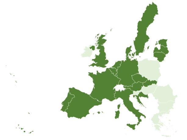
GSA/OP/09/16/Lot 3/SC2
D4.1 – Analysis of the most promising road payment/liability critical applications for EGNOS adoption in 2025-2035

Figure 5-1: The distribution of shared mobility services .............................................................. 40
Figure 5-2: Provisional Value chain of Taxi meter ...................................................................... 43
Figure 5-3: Provisional VC of car sharing ................................................................................... 47
Figure 5-4: Number of car-sharing users in Europe in 2014, by country .................................... 46
Figure 5-5: Number of car-sharing vehicles in Europe in 2014, by country ................................ 46
Figure 5-6: Number of car-sharing users worldwide from 2006 to 2025 (in millions) ........... Error!
      Bookmark not defined.
Figure 5-7: GNSS devices in Car sharing ..................................... Error! Bookmark not defined.
Figure 5-8: Provisional VC of car rental ...................................................................................... 50
Figure 5-9: GNSS devices in car rental ......................................... Error! Bookmark not defined.

                                                                4
1 Introduction

Payment critical applications links the billing with the position and timing provided by an in vehicle GNSS
device. The GNSS requirements requested by these applications depend on the nature of the service. For
example, Electronic toll collection (ETC) will request a higher accuracy than Pay Per Use Insurance, because
there is a higher risk to charge a vehicle, that is not a user of the tolling road. Despite the fact that some
applications currently demand certified devices (e.g. taximeters), new applications are providing the same
service (e.g. Uber) without this additional layer of trustworthiness, considered as a legal mean of measuring
distance. New mobility service providers are using GNSS embedded in the vehicle, added via separate on-
board unit or just via separate smartphone or tablet device. This type of service could be used also by taxis
and will be cheaper than a mechanical mean of distance measuring. Accuracy, availability, integrity in towns
and authenticity are the main performance indicators in this case. Indeed, cybersecurity threats will also affect
the reliability of many payment applications. According to the GSA road report on user needs and
requirements, the GNSS positioning and timing has not yet an adequate status in the legal metrology to allow
financial transactions1, meaning that in some cases such as taxi meters the GNSS technology is not
recognised as valid proof for timing and distance that can generate payment transaction 2This shortfall can
slow down the deployment of GNSS in payment critical application.
Liability Critical Applications are those where the consequences on navigation of undetected GNSS miss-
performances can generate significant legal or economic consequences. Payment critical Applications (PCA)
are also liability-critical applications, because the position errors can have a direct economic impact on the
service providers and on the users (mischarging or overcharging). In addition, there are applications which are
only liability critical such as Smart Tachograph.
Leading chipset manufacturers companies such as Broadcom are very interested in the new authentication
feature being introduced by Galileo3, which will allow users to check and verify that a navigation signal is really
coming from a satellite and not from someone trying to 'spoof' their location. This feature is extremely relevant
when related to applications that involve payments, like Electronic toll collection or parking fees based on your
location4.
The identified main applications that might potentially benefit from integrity and a higher accuracy of EGNOS
service in the 2025 – 2035 timeframe are summarised in the following table:

1 https://www.gsc-europa.eu/system/files/galileo_documents/Road-Report-on-User-Needs-and-Requirements-v1.0.pdf
2 Directive 2014/32/EU on measuring instruments (MID)
3 https://www.gsa.europa.eu/newsroom/news/gsa-mobile-industry-leaders-explore-future-location-infoshare-2017
4https://www.gsa.europa.eu/newsroom/news/gsa-mobile-industry-leaders-explore-future-location-infoshare-2017

                                                        5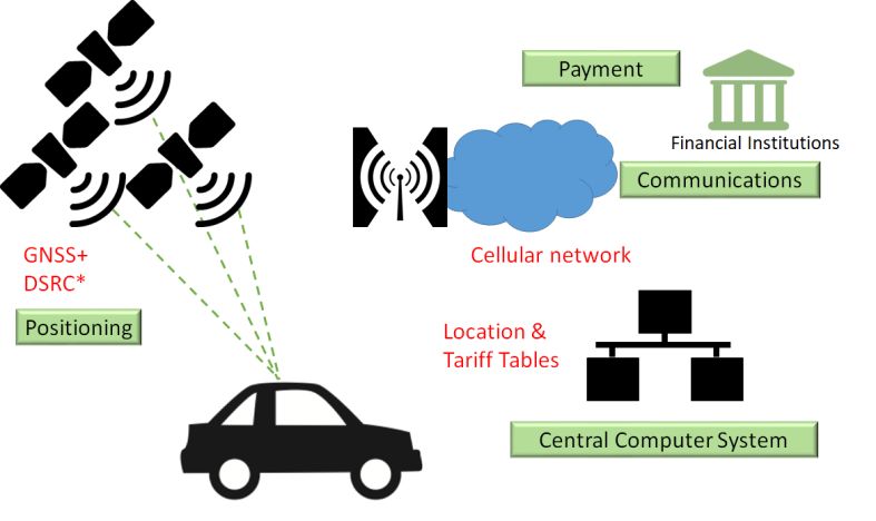
Table 1-1: Selected payment/liability critical applications

   Location based charging              Insurance and liability         On-demand mobility
         applications
 Electronic     toll   collection   Insurance telematics           Taxi meter
 (ETC) (payment critical)           (payment critical)             (payment critical)
 Zone Billing                       Smart Tachograph               Car Sharing
 (payment critical)                 (liability critical)           (payment critical)
 On-street parking                                                 Car rental
 (payment critical)                                                (payment critical)

This document was prepared by VVA and FDC.

2 Methodology

Segmentation
    ▪   A preliminary segmentation is made to organise the applications in the report by type. For each
        application a market analysis will be performed to assess: market trends, user requirements, key
        players and potential future market size.
    ▪   Location based charging (LBC) is a set of services in which a special fee is applied to the
        subscriber whenever he utilises the service. Electronic toll collection and Zone billing applications are
        part of this category.
    ▪   Insurance and liability encompass insurance telematics application, which is an aftermarket service
        together with a regulated liability application called Smart Tachograph.
    ▪   On-demand mobility includes applications such as car rental, car sharing, taxi meters. It provides the
        customers access to transportation and mobility services on demand.

User needs and requirements
The user needs and requirements provided in this document mostly come from the GSA User Consultation
Process (UCP), in particular from the Report on road user needs and requirements. The applications covered
during the UCP are Electronic toll collection, Insurance telematics applications (Pay As You Drive and Pay Per
Use Insurance), Taxi meter, On-street parking and Smart Tachograph application. For the applications Zone
billing, Car sharing and Car rental, desk researches were performed. These requirements are presented
considering the potential future use of GNSS for these applications. The user needs and requirements were
then validated and updated based on the completed questionnaires by the focus groups. All the user
requirements parameters are defined in Annex 1.

Market sizing
    ▪   For applications already in the Market Monitoring and Forecasting Tool (MMFT) the MMFT data were
        used as the basis of the market forecast of GNSS devices and the penetration of EGNOS were
        estimated based on desk research and stakeholder’s consultation. This approach is valid for ETC,
        Insurance telematics, car sharing, car rental and smart tachograph.

                                                           6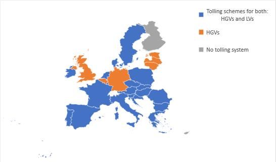
▪ For new applications, it was estimated the existing and forecasted market for GNSS and EGNOS
based on desk research and stakeholder’s consultation. This approach is valid for On street parking,
Zone billing and Taxi meter.
Validation activities
To validate the outcomes of the study the Consortium created 3 focus groups (based on the current
segmentation), each representing around 5 stakeholders:
▪ Focus Group 1: Location Based Charging
ETC
Zone Billing
On-street parking
▪ Focus Group 2: Insurance and liability
Insurance telematics
Smart Tachograph5
▪ Focus Group 3: On-demand mobility
Car sharing
Car rental
Taxi meter
Questionnaires were elaborated, focusing on validation questions covering all the aspects of the report. They
were distributed among all the focus groups and feedback was provided via bilateral discussions or by written
means. As a final step, a webinar was organised on the 9th of May 2019, to discuss the feedback from the
questionnaires and present the final outcomes of the study. The webinar was attended by representatives from
Insurance telematics and LBC applications. The final report presents the revised version of the analysis based
on the stakeholders’ feedback.
2.1 List of acronyms
All acronyms and abbreviations mentioned in this report can be found in the table below.
Table 2 List of acronyms
Acronym Definition
AETIS Association of Electronic Toll and Interoperable Services
ANPR Automatic Number Plate Recognition
ASECAP European Association of Operators of Toll Road infrastructures
CAGR Compound Annual Growth Rate
CC Congestion Charge
CCS Central Computer System
CN Cellular Networks
DSRC Dedicated Short Range Communications
5 Due to the complex environment of this application, no validation activities are performed with smart tachograph
stakeholders
7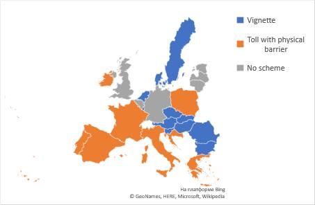
Acronym                                               Definition
EC              European Commission
EDAS            EGNOS Data Access Service
EETS            European Electronic Toll Service
EGNOS           European Geostationary Navigation Overlay Service
EGNSS           European GNSS
ES              Enforcement Systems
ETC             Electronic Toll Collection
ETS             Electronic Toll Service
EU              European Union
GNSS            Global Navigation Satellite System
GPRS            General Packet Radio Service
GPS             Global Positioning System
GSM             Global System for Mobile Communications
HDVs            Heavy Duty Vehicles
HGVs            Heavy Goods Vehicles
IR              Integrity Risk
LBC             Location based charging
LEZ             Low Emission Zone
LVs             Light Vehicles
MaaS            Mobility as a Service
MMFT            Market Monitoring and Forecasting Tool
NeuV            New Electric Urban Vehicle
OBD             On-board diagnostics
OBU             On-Board Units
OEMs            Original equipment manufacturers
P2P             Peer-to-Peer (car sharing services)
PAYD            Pay as you drive
PCA             Payment critical Applications
PD              Probability of Detection
Pfa             Probability of false alarm
PHYD            Pay how you drive insurance policies
PL              Protection Level
PVT             Position, Velocity and Time
REETS           Regional European Electronic Toll Service
RFID            radio frequency identification
RSE             Roadside equipment
RSU             Road Side Units
ST              Smart Tachograph
TfL             London transport authority
UBI             Usage-based insurance
UCP             GSA User Consultation Platform

                                                       8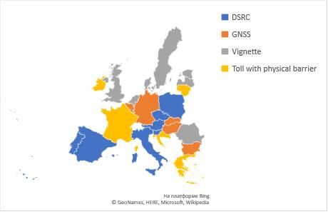
Acronym                                                   Definition
 URR                   User Requirements Report
 UTP                   Unified Telematics Platform
 VC                    Value chain
 VU                    Vehicle Unit

3 Location-based charging applications

3.1       Electronic toll collection (ETC)

3.1.1      Application description

As specified in the EU directive on the interoperability of tolling systems, GNSS positioning and timing
information already constitutes the basis for several electronic road pricing systems implemented in the EU.
Electronic payment to charge for usage of road infrastructure most often forms the funding necessary for its
upkeep.

Electronic tolling, including the conditions of interoperability of electronic toll systems are regulated by Directive
2004/52/EC (The European Electronic Toll Service (EETS)Directive) and subsequent directives. A technical
prerequisite for interoperability between national toll collection systems or frameworks of Electronic Fee
Collection (EFC), is that EETS On-board Equipment (OBU) provided by European tolling operators will have
to support the three technologies specified in the directive, namely GNSS, 5.8GHz microwave and
GSM/GPRS.

      ▪    5.8GHz microwave/DSRC: For dedicated short-range communications (DSRC)-based systems toll is
           calculated based on bidirectional radio communication exchanges between roadside equipment (RSE)
           and On-Board Units (OBU). The OBU installed inside the vehicle communicates all the necessary
           information for toll processing to the RSE, including vehicle’s and user’s parameters. The user is
           identified by the RSE to trigger payment.
      ▪    GNSS: the information collected (e.g. route travelled by vehicle and/or vehicle positioning data) by
           GNSS-based OBUs constitutes the basis for toll calculation. Even though localisation augmentation
           may be provided through communication with roadside equipment in areas with limited signal
           reception, satellite-based solutions require significantly less ground-infrastructure.
      ▪    GSM-GPRS: Mobile communications are used for the transmission of charging information to the data
           centre (back office) as well as updates using existing mobile network infrastructure, in the context of
           satellite-based tolling systems.

Currently operating charging schemes are either DSCR or GNSS/Cellular Networks (CN)-based systems.
Although DSCR is seen as a more mature, well-established technology in the tolling domain, the GINA project
highlights the potential of GNSS-based systems in terms of cost-effectiveness for more complex, distance-
based charging schemes for wider/all network coverage (national implementation). This is mainly due to the

                                                           9
rising costs of operation as well as ground infrastructure deployment in alternative solutions e.g. DSCR.6 GNSS
solutions are more flexible (compared to fixed DSCR gantries operators can virtually modify which road
segments are subject to tolling) and more efficient for wider road network coverage. Satellite-based systems
can easily enlarge or reduce charging schemes coverage when needed, ultimately increasing the volume and
efficiency of road transports.
The figure below represents an illustration of the two possibilities of implementing free-flow tolling systems
based on GNSS/CN and DSRC technologies respectively:
Figure 3-1:Technology alternatives: GNSS and DSRC
Source: Q-free
Microwave gantries are used for charging and compliance checking in DSCR-based toll systems.
The GNSS-based On-board Equipment or OBU refers to the complete set of hardware and software required
for EETS service provision. The device installed in the vehicle collects, stores, processes and remotely
receives/transmits data (e.g. vehicle’s positioning and passages across charging points). The passage of a
vehicle across a charging point is recorded by continuously comparing the positions of the vehicles and these
virtual gantries (i.e. map-matching). The comparison can be performed either inside the OBU (in the case of
thick client approach) or in the back-office (in the case of a thin client approach7).8
EETS Provider’s back-office systems receive toll relevant data (charge data) produced by the OBU which
may be subject to further processing before being transferred to the Toll Charger via back-office
communication (billing details). In case of DSCR-based tolling charge data is sent to the Toll Charger RSE
and further processed billing details are sent to the service provider’ back-end.
Toll Charger’s back-office systems exchange and confirm billing details which constitute the basis of toll
claim from the Toll Charger to the Service Provider.
6The absence of ground infrastructure was the decisive element in the choice for a GNSS-based scheme for Skytoll
operating on behalf of Slovakian road transport authorities
https://www.mobility.siemens.com/mobility/global/SiteCollectionDocuments/en/road-solutions/interurban/tolling-systems-
for-freeways/sitraffic-sensus-in-slovakia-en.pdf
7https://ec.europa.eu/transport/sites/transport/files/modes/road/road_charging/doc/study-electronic-road-tolling.pdf
8
10The role of GNSS is to provide positioning information required for toll calculation: Satellite technology allows
the system to recognise each OBU and calculate position and direction at each virtual gantry. Based on this
information, toll is calculated. GSM/GPRS modules are used for data transmission to the European Electronic
Toll Service (EETS) provider and Toll Charger (e.g. updates on toll rates and new road segments).
The way this GNSS critical-payment application is working depends on the allocations of responsibilities
among two of the key players (service providers and toll chargers). The following figure presents a situation
where the dominant position is taken by the toll charger:
Figure 3-2: GNSS based Electronic toll collection process (Toll charger leader)
Source: VVA adapted from https://www.aetis-europe.eu/eets.html
In other cases, the service providers are taking much more responsibilities and execute the entire process,
thus offering the public or private toll chargers only a monitoring and supervision role:
11Figure 3-3 GNSS based Electronic toll collection process (Service provider leader)
Source: VVA adapted from https://www.aetis-europe.eu/eets.html
The Eurovignette Directive (1999/62/EC) represents the legal framework for heavy good vehicle taxation. It
provides rules for Member States which decide to introduce road charges i.e. tolling or vignettes. The EC
adopted a proposal in 2017 for extending the scope of the directive to Heavy and Light Duty Vehicles, including
passenger cars. In addition, the proposal aims to shift from time-based taxation (current vignettes) to distance-
based charging, which is considered as more efficient and effective, by the end of 2023 for Heavy Goods
Vehicles (HGVs).9 Main charging schemes in the EU are:
• Distance-based charge (i.e. toll) typically levied at physical road barriers such as a row of tollbooths,
known as a toll plaza; tolls might vary according to vehicle type (e.g. environmental performance) or
time (e.g. time of day).
• Time-based charge (i.e. vignette): whereby road users have to buy a vignette (i.e. a sticker or
document to be placed on the vehicle's windscreen) that allows the vehicle to use the infrastructure
for a specific period of time10.
9http://www.europarl.europa.eu/legislative-train/theme-resilient-energy-union-with-a-climate-change-policy/file-jd-
eurovignette-directive-revision
https://www.euractiv.com/section/road-charging/news/fifteen-eu-countries-will-be-forced-to-change-road-toll-laws-under-
draft-rules/
10 EPRS
123.1.2 Market trends and size
Figure 3-4: Overview of tolling schemes implementation in the EU, per vehicle type
Source: VVA
As shown above, the large majority of countries has put in place some form of taxation for at least one of the
road users categories.
In the case of heavy goods vehicles (HGVs), most of the operating schemes exclusively rely on OBUs:
Austria11, Czech Republic, Germany, Hungary, Poland, Portugal, Slovakia, Belgium and recently Bulgaria.12
In other countries with electronic tolling system both manual and electronic tolling are available. In addition,
the Czech Republic plan roll-out of road tolling systems based on satellite technologies for HGVs in 2020 to
replace its existing DSCR-based scheme.13
11 https://www.asfinag.at/toll/go-box-for-hgv-and-bus/
12 https://eur-lex.europa.eu/legal-content/EN/TXT/PDF/?uri=CELEX:52017SC0192&from=EN
13 http://blog.vialtis.com/index.php/bulgaria-toll-transition-to-eets/?lang=en
https://www.skytoll.com/skytolls-statement-on-winning-the-tender-to-operate-the-electronic-toll-system-in-the-czech-
republic/
13Figure 5 Current implementation of road user charges for HGVs
Table 3 Overview of existing schemes for HGVs
EU28 Country Schemes for HGVs
Austria DSRC OBU-based toll collection
Belgium GNSS OBU-based toll collection
Bulgaria GNSS OBU-based toll collection
Croatia Manual toll
Czech Republic DSRC OBU-based toll collection
Denmark Eurovignette
Estonia Time-based toll (vignette)
France Manual toll14
Germany GNSS OBU-based toll collection
Greece Manual toll
Hungary GNSS OBU-based toll collection
Ireland Manual toll
Italy DSRC OBU-based toll collection
Latvia Time-based charge
Lithuania Manual toll
Luxembourg Eurovignette
Netherlands Eurovignette
Poland DSRC OBU-based toll collection
Portugal DSRC OBU-based toll collection
14 Automatic payment system using DSRC-based device
14EU28 Country Schemes for HGVs
Romania Vignette
Slovakia GNSS OBU-based toll collection
Slovenia DSRC OBU-based toll collection
Spain DSRC OBU-based toll collection
Sweden Eurovignette
United Kingdom Vignette
Operating GNSS-based schemes in the EU28 include Belgian Viapass (for HGVs over 3.5 tons, operational
since 2016), German LKW-Maut (HGVs of 7.5 tonnes or above15), Hungarian HU-GO(Heavy goods vehicle
with a maximum total permissible weight over 3.5 tons16, Slovakia’s Skytoll system (launched in 2010 for HGVs
ale-vignettes for vehicles under 3.5).
Private car users are subject to tolls on motorways with electronic tolling systems implemented on significant
parts of the road networks in Croatia, France, Greece, Ireland, Italy, Poland, Portugal and Spain. When it
comes to payment, users are able to choose between manual payment (at toll booths) and the purchase of a
device.
Figure 6 Current implementation of road user charges for LVs
Table 4 Overview of existing schemes for LVs
EU28 Country Passenger cars
Austria Sticker or e-vignette
Belgium N/A
Bulgaria E-vignette
Croatia Manual toll
15 https://www.toll-collect.de/en/toll_collect/rund_um_die_maut/mautpflichtige_fahrzeuge/mautpflichtige_fahrzeuge.html
16 https://www.hu-go.hu/articles/article/about-the-introduction-of-the-system
15EU28 Country Passenger cars
Czech Republic Sticker/vignette
Denmark Eurovignette
Estonia N/A
France Manual toll17
Germany N/A
Greece Manual toll
Hungary Time-based sticker (vignette)
Ireland Manual toll
Italy Manual toll
Latvia N/A
Lithuania N/A
Luxembourg Eurovignette
Netherlands Eurovignette
Poland Manual toll
Portugal Manual toll18
Romania Vignette
Slovakia E-vignette
Slovenia E-vignette
Spain Manual toll19
Sweden Eurovignette
United Kingdom N/A20
When it comes to the legal framework, above-mentioned EETS Directive needs to be harmonised as foreign
drivers experienced some difficulties during the payments in other countries, due to different On-Board Units
(OBUs) needed for each country. To tackle the problem, the REETS (Regional European Electronic Toll
Service) Project aims at reducing barriers for EETS deployment by reducing business uncertainty for EETS
providers in order to prevent potential market failure of European Electronic Toll Collection services. The
Project shall cover the electronic toll network of 7 Member States (Austria, Denmark, France, Germany, Italy,
Poland and Spain) and Switzerland.
17 Automatic payment system using DSRC-based device
18 With possibility to purchase DSRC-device
19 Possibility to purchase DSRC-based OBU
20 The M6 toll is a toll plaza for https://www.m6toll.co.uk/
16Figure 3-7: Overview of GNSS tolling schemes in 2025
Legend
▪ Usage of DSRC solution
▪ More likely to adopt GNSS
▪ Less likely to adopt GNSS
▪ Grey: No tolling scheme
Source: Ptolemus, The next global ETC market, next battleground for connected services, 2018
The choice of future technology for new tolling schemes is divided between DSCR and GNSS-based systems.
The advantage of satellite systems for network-wide Electronic toll collection systems are evident in terms of
their flexibility and cost-effectiveness. Although continuous monitoring through GNSS equipped OBUs may
hinder wider public acceptance, satellite solutions have been seen as an effective way of managing HGVs
flows.
In addition to countries which have already implemented Electronic toll collection schemes based on satellite
technologies (e.g. Germany and Belgium), Netherlands, Bulgaria and Czech Republic are very likely to
introduce GNSS-based systems. France, UK, as well as current Eurovignette countries such as Sweden and
Denmark might also opt for satellite-based technologies, although this is less certain. 21
3.1.3 Industry Value chain
The following figure presents the value chain of the Electronic toll collection application with a non-exhaustive
list of companies as an example:
21 https://www.roaduserchargingconference.co.uk/wp-content/uploads/sites/88/2018/03/Justin-Hamiliton_reduced.pdf
17Figure 3-8: Validated ETC value chain
Source: VVA
Electronic Toll Service providers are equipped with OBUs with integrated GNSS receivers, by Tier 1 suppliers.
OBUs are installed in the ETS users’ vehicles to enable service. The device installed in the vehicle collects,
stores, processes and remotely exchanges data (e.g. vehicle’s passages across charging points). Finally
based on toll data received from the OBU as well as exchanges of records with the EETS service provider, the
toll charger levies the fees for the vehicle’s circulation in the designated areas.
Regarding the future evolution of the value chain, stakeholders foresee that similarly to other applications (e.g.
Insurance Telematics) OEMs are expected to emerge as dominating players once dedicated (aftermarket)
devices will be replaced by in-vehicle systems. One stakeholder foresees seamless integration of mobility
services (and seamless travel as a part of Mobility as a Service (MaaS), across modes of transportation and
borders).This will happen through the integration of smartphones with the connected vehicle’s infotainment
systems.
Other stakeholders suggest that the financing of the ETC provider should be clarified (possibly though financial
support from the toll charger) and harmonized tolling systems should offer a single, free OBU. In addition to
market consolidation and possible entry of new players (e.g. investment funds and financial institutions),
stakeholders expect that in 10-15 years’ service will be extended to private vehicles.
The table below represents some examples of the key players within GNSS based Electronic toll collection.
18Figure 3-9: Examples of key players in the GNSS based Electronic toll collection application
Electronic Toll service provider Operating country Toll charger
Kapsch Telematic Services on behalf of
Eurowag (WAG Payment Solution
Czech Republic the Road and Motorway Directorate of
a.s.)
the Czech Republic (RSD)
Total Marketing Services ASFA
Eurotoll France
Axxès SAS
AGES EETS GmbH Germany TOLL COLLECT GmbH
Telepass S.p.A Italy AISCAT
It should be noted that in the future, the Tolling service provider can be a larger stakeholder type called the
“service enabler”. The service enabler typically offers more than one service and charging tolling services is
just a small part of their portfolio. (e.g. a black box provider enabling on street-parking, zone billing and
Electronic toll collection in one).
When it comes to cross-border cooperation, tolling operators are active within ASECAP (European Association
of Operators of Toll Road infrastructures) and AETIS (Association of Electronic Toll and Interoperable
Services), but this association represents 15 members in the European Union out of the 28 EU members
States.
3.1.4 User needs and requirements
The following table summarises the most stringent user requirements associated to the Electronic toll collection
application. Data updated from stakeholder consultation is presented in red.
Table 3-5: ETC requirements
Requirement parameters Values
Performance requirements
Availability 99.95%22 (updated from 99.9% in the
UCP)
Horizontal accuracy 1m
Vertical accuracy 5 m23 (updated from roughly 10 m in the
UCP)
Position integrity Medium (Protection Level (PL) < 25 m at
Integrity Risk (IR)=10exp-4,
Probability of false alarm (Pfa) < 0.2%
and Probability of Detection (PD) > 85%)
22 In addition to the more stringent value compared to the originally suggested one by the UCP, stakeholders explain that
it is more interesting for how long each loss of data is, instead of showing availability as a percentage of total time per
month.
23 Stakeholder suggest parameter should be more stringent to consider elevated roads.
19Time to First Fix24 Cold start25 ≤ 30 s ; Warm start26 ≤10 s
Operational requirements
Environmental constraints Motorways crossing each other, tunnels
Functional requirements
Robustness to spoofing High
Robustness to interferences High
Legal requirements
Applicable regulation Directive 2004/52/EC
According to the report27 on GNSS adoption for Electronic toll collection in Europe released by the GSA, four
of these parameters are crucial for a robust and efficient tolling service based on GNSS: availability, integrity
and robustness to spoofing and jamming.
Availability is a function of both the physical characteristics of the local environment and the navigation system
capabilities. A low GNSS availability could adversely impact the algorithms computing the charging data by
making it either impossible or approximate which could have financial implications for the user or for the toll
charger. Thus, availability is a key parameter and shall not be lower than 95%.
Virtual gantry crossing detection must be reliable in order to avoid the risk that a user’s reported position
triggers a charging event when it is actually in a free-of-charge position. Thus, integrity is a key parameter,
with a required probability of false alarm under 0.2%, a probability of detection over 85%, and a protection
level under 25 m at an integrity risk of 10exp-4.
Interference could prevent the GNSS receiver from providing a PVT, having a similar consequence as a low
GNSS availability.
Intentional attacks of the GNSS receiver like jamming or spoofing could be implemented by vehicles users to
avoid charging. A jamming attack would have the same effect as an unintentional interference but could last
during the whole trip. Robustness against interference could prevent from losing PVT in case of an attack.
Or at least detection of jamming would allow imposing sanctions or fines to compensate the loss of earnings
by the tolling provider.
Even more critical, a spoofing attack would for instance make the GNSS receiver calculating a fix position or
a trajectory using only free-of-charge roads.
Stakeholders confirm that economic impact of GNSS spoofing is significant. Similarly, there is a critical need
to guarantee robustness, as impact there is an incentive to bypass tolling fees and respective economic impact
can also be significant. One stakeholder adds that robustness should be a measurable parameter, for instance
defined in terms of the ease of detecting manipulation or cases of manipulation identified within a period
(month, quarter, year). Another interviewee confirms that it is difficult to spoof GNSS receiver with
Authentication.
24 Value is confirmed by stakeholders; one suggestion is to distinguish between cold start and warm start situations: in cold
start situation the value of 30 seconds is acceptable but in warm start situations (when the system is already switched ON)
this should be below 10 seconds.
25 Cold start: the receiver has no knowledge of the current situation and must thus systematically search for and identify
signals before processing them – a process that can take up to several minutes.
26 Warm start: the receiver has estimates of the current situation – typically taking tens of seconds.
27 https://www.gsa.europa.eu/system/files/documents/ruc-brochure.pdf
203.2 Zone Billing
3.2.1 Application description
Charging vehicles positioned in specific areas at different rates than in other locations i.e. zone billing is used
for redistribution of traffic across road network (e.g. route, time of the day) but also, in the longer term, to
encourage a modal shift in traffic behaviour (e.g. in favour of alternative transport means such as public
transport or cycling). Such locations can be Low-emission zones or Congestion Charge Zones. The emphasis
in the implementation of such systems is thus to minimize negative externalities of traffic, rather than to cover
expenses for road infrastructure.
In addition to the solutions enabling European Electronic Toll Service (EETS) provision (DSCR, GNSS and
GSM/GPRS), area-based charge technologies include ANPR (Automatic Number Plate Recognition).
In the ANPR-based systems, images taken of vehicles’ license plates are processed through optical character
recognition software to identify the vehicle by its plate number and cameras monitor vehicles entering and
existing zones. Initial schemes simply record vehicles passing the cordon boundaries, with fines issued to
drivers who have not paid for access, using the local database to trace vehicles (e.g. London, Edinburgh,
Milan). Other schemes use data captured through the system (cameras, data communication infrastructure
and automatic plate recognition) to identify the vehicles entering the charging zone and compute charges
based on pre-established rates (e.g. Valetta, Stockholm, Gothenburg).
3.2.2 Market trends and size
Singapore will be the first to introduce a full network GNSS urban congestion pricing scheme by 2020,
to charge users based on the distance travelled in a congested zone rather than a flat charge for entering the
defined zone. The introduction of a GNSS-based (GPS) pricing scheme will reduce the number and size of
gantries (ANPR cameras will be retained for enforcement purposes to limit the impact on urban landscape). In
addition, GNSS will enable distance-based pricing and flexibility given that the position of virtual gantries is not
fixed, translating into more efficient traffic management. The system’s flexibility also allows for adjustments
and dynamic charging rates to accommodate to real-traffic situations (e.g. accidents).
The next-generation Electronic Road Payment system in Singapore tender was awarded (by the Land
Transport Authority) to a collaboration between Mitsubishi Heavy Industries, the Electronic Toll Collection
System developer (Intelligent Transport Systems supplier), and NCS Pte Ltd, an information technology
provider whose role will be to integrate the system and overall solution 28.
While the use of GNSS based systems is mainly restricted to truck or heavy weight vehicles tolling across
mainland Europe, zone billing is oriented towards managing traffic flows for all vehicle types. Operational
28 https://www.mhi.com/news/story/1603091964.html
21Congestion Charge (CC) schemes in Europe are based on ANPR Systems (e.g. London, Stockholm, Milan,
Oslo, Gothenburg), whereby vehicles are automatically registered by cameras capturing their number plates.
The London system is a pre-payment system based on drivers’ liability: drivers pay a flat daily rate and
enforcement is carried out by authorities through random checks for vehicles entering the congestion charge
zone using roadside cameras. The reduction of emissions caused by vehicles was initially addressed by
policymakers in Stockholm through setting up a Low Emission Zone (LEZ). Following the LEZ, Stockholm’s
implementation of the CC (initially based on a combination of DSRC and ANPR), further enhanced traffic
mobility and air quality29.
A number of cities have considered GNSS for introducing congestion charging schemes for all vehicles i.e.
including Passenger Cars and Light Vehicles. As part of its goal to become the first carbon neutral capital by
2025, Copenhagen examined a congestion charge scheme to manage urban traffic flows. Sund & Bælt in
Denmark, together with OBE suppliers Siemens and Kapsch, conducted a trial which proved the technical
feasibility of implementing GNSS-based system with toll bounds in and around the Copenhagen area. 30 Among
existing schemes, the London transport authority (TfL) published a recent study where it lists the possibility of
extending the current coverage, moving away from a flat congestion charge fee to road pricing i.e. nuancing
its charges (per time of the day and emissions level) among the measures to tackle increasing levels of
congestion. Such a comprehensive road pricing scheme which would target areas where traffic is most
concentrated would be possible using satellite-based technologies.31 As the third city to implement Congestion
Charging, Stockholm also considered a GNSS system. Nevertheless, the system was deemed relatively
expensive for two reasons: one is that in order for the system to be able to track a vehicle at all times additional
roadside infrastructure (e.g. monitoring equipment) would be required for areas with weak satellite signal
reception; in addition, the installation of GNSS-enabled OBUs in every vehicle was also seen as problematic.
29 Study on International Practices for Low Emission Zone and Congestion Charging by Beijing Transport Authority,2017
30GNSS Tolling: Ability to Detect Correct Road Usage based on Geo-Objects and Map-Matching Methods by Martina
Zabic,2018
31Understanding and Managing Congestion by Integrated Transport Planning Ltd (On behalf of: Greater London
Authority),2017; At the same time remote monitoring (including through satellite technology) by a government agency has
raised concerns in another report published by the Transport Committee.
London stalling. Reducing traffic congestion in London, Transport Committee, London Assembly, February 2017.
https://www.london.gov.uk/about-us/london-assembly/london-assembly-publications/london-stalling-reducing-traffic-
congestion
22Figure 3-10: Overview of existing environmental zones in Europe 2018
Legend:
• Countries with defined
environmental zones
• Countries without defined
environmental zones
Source: http://urbanaccessregulations.eu/
Most EU countries have already introduced environmental or Low Emission Zones (LEZ) to address the issue
of pollution in urban areas (e.g. Paris, Lisbon, Brussels) except for Bulgaria, Poland, Slovenia, Romania,
Greece, Hungary and Ireland.
To estimate the market size, the assessment started by looking at the number of targeted cities for zone billing
and their growth rate over the 2025-20235 period. Then, the assessment also looked at the average number
of vehicles per thousands of people compared to the average population of the target cities to identify the
potential market of zone billing. In conclusion, in 2025 the potential market of zone billing is around 35 million
vehicles going up to 55 million vehicles in 2035.
3.2.3 Industry Value chain
The following figure presents the value chain of the Zone billing application with a non-exhaustive list of
companies as an example:
23Figure 3-11: Validated32 Zone billing value chain
Source:VVA
Although existing schemes rely on alternative technologies (e.g. ANPR), the future GNSS-based systems are
foreseen to function in a similar way. Given that congestion charging schemes are usually ran by local or
national authorities, the subcontractor(s) for implementing the full technical solution (including the hardware
GNSS equipped OBUs and software) are chosen by public bodies. Solution providers can be Tier 1 suppliers
or collaborations between actors with different expertise. Service users are charged based on the tariffs and
scheme in place.
Stakeholders confirmed the value chain presented. It was suggested that Norway is an important market,
especially when it comes to urban tolling so the respective local public authority (Statens Vegvesen / The
NPRA ) and respective EFC supplier (Efkon) were additionally included. Some stakeholders also foresee a
convergence between the ETC and Zone billing applications.
32Participants to the ”Location Based charging applications” focus group agreed with the presented value chain and had
no further remarks. However, it should be noted that none of the active solution providers in the on-street parking
application participated.
24Figure 3-12: Architecture of GNSS-based ERP System in Singapore
Source: LTA
▪ OBU, the device installed in the vehicle independently calculates the charge based on positioning
information and is capable to transfer this information (charging and vehicle positioning) to the Central
Computer System. An acceleration sensor and gyroscope inside the OBU will aid positioning in case
of GNSS signal instability. The travel path and charging points are confirmed from the positioning
information obtained from map matching (technical positioning information is matched with an
electronic map).
▪ Central Computer System (CCS) is a processing system which exchanges information with the
various sub-systems. It receives the charging rate from the OBU and transmits it billing information.
To determine whether the charge has been successfully executed or in case of infringements, the
CCS receives monitoring information from the roadside equipment. The CCS also disseminates traffic
information collected through the roadside equipment from individual OBUs in order to manage traffic
flows (by suggesting alternative routes to guide drivers away from congested areas).
▪ RSU (Road Side Units) are communication devices providing traffic information as well as enhancing
positioning information in case of GNSS unavailability in certain areas (e.g. urban canyons) through
exchanges with the OBU.
▪ In addition, the ES (Enforcement Systems) consisting of mobile (e.g. installed on enforcement
vehicles) and fixed monitoring systems (roadside equipment) are able to detect infringements based
on information exchanges with OBUs via DSRC and number plate recognition33.
3.2.4 User needs and requirements
The following table summarises the user requirements for the Zone Billing application.
33 Study on International Practices for Low Emission Zone and Congestion Charging by Beijing Transport Authority,2017
25Very few references3435 were found to complete the user requirements for this application. The user
requirements are based on Consortium knowledge and have been validated during focus groups organized by
the Consortium.36 Data updated from stakeholder consultation is presented in red.
Table 3-6: User requirements for Zone billing application
Requirement parameters Values
Performance requirements
Availability 99.9%
Horizontal accuracy 1m
Vertical accuracy not applicable37
Position integrity Medium (PL < 25 m at IR=10exp-4,
Pfa < 0.2% and PD > 85%)
Time to First Fix ≤ 30 s
Operational requirements
Environmental constraints Urban
Functional requirements
Robustness to spoofing Medium
Robustness to interferences High
Legal requirements
Applicable regulation None
Zone billing application is based on the concepts of geofencing in which access to specific zones is linked to
rules or constraints.
Integrity is also a key parameter since the billing process will be triggered by the comparison between the
position of the vehicle and a virtual zone boundary.
For the same reason, robustness against spoofing is crucial. For instance, a user could simulate a fix point
outside the charged zone and enter the zone without being detected. The attack would be performed by the
end user using record and replay equipment.
Robustness against interference is also required since the GNSS receiver would no more be able to provide
PVT which would be a problem in case the interference lasts during a long period or intervene at a moment
inducing ambiguity (a long interference disturbing the GNSS receiver during an exit of the charged zone for
instance).
34 https://www.etsi.org/deliver/etsi_tr/103100_103199/103183/01.01.01_60/tr_103183v010101p.pdf
35 https://skynet.ee.ic.ac.uk/~hcommin/ComminDissertation.pdf
36 User requirements were presented to participants of the ”Location Based charging applications” focus group. However
it should be noted that none of the active solution providers in the on-street parking application did not participate.
37 Stakeholders confirm the parameter is not applicable in the context of zone billing.
26Stakeholders streamlined their feedback on user needs and requirements for both applications (ETC and Zone
billing.) However, a number of parameters applicable for Zone billing are less stringent compared to ETC. On
the other hand, EGNOS is expected to bring similar benefits.
3.3 On-street parking
3.3.1 Application description
On street parking is a type of vehicle parking system that can be enhanced with positioning and timing data
provided by satellites in order to calculate the parking fee. In addition, using sensors in each parking space
can detect the presence or absence of a vehicle, signs direct incoming drivers to available locations.
In the case of dynamic parking, the vehicle is charged based on the time spent in the defined (parking) area
upon entering or leaving the zone. Payment can be processed through the OBU complementary to the ETC
application (e.g. parking payment will be integrated into Singapore’s new electronic road pricing system 38).
Alternative technology includes radio frequency identification (RFID) tags implemented by cities into parking
permits, but in most cases smart parking involves integrating data from multiple sensors, including GNSS
positioning data.
3.3.2 Market trends and size
Current on-street parking solutions are available in the form of predictive services 39 offered in Europe by HD
map providers such as TomTom40 or HERE. The information combines static data sets e.g. GPS coordinates,
pricing rates, parking policies with dynamic data sets e.g. probability of finding a parking spot or average
search-time for a spot . Parking availability data is received from smart sensors installed in on-street parking
places, where available. When no such sensors are available algorithms are used to predict availability based
on historical data.
Such real-traffic and predictive information services are also integrated into connected vehicles. For instance,
INRIX and BMW’s collaboration connects open data from cities parking inventories with their own traffic data
to provide real-time information on parking activity as part of BMW’s connected car services4142.End-to-end
solutions integrate mobile payments through apps. ParkNow provides on-demand mobile payments in several
countries including Austria, France, Belgium, Germany, Switzerland and Netherlands. Based on its
smartphone positioning information, a user selects parking zone through the app and determines the length of
the parking session, thereby replacing the need for a metering device.
A recent trend is that OEMs choose to collaborate with a single parking service provider to offer embedded
end-to end parking solutions, including parking availability, payment and navigation services (Parkopedia
38http://www.itsinternational.com/event-news/intertraffic/2016/news/mitsubishi-wins-singapore-erp-contract/
39https://www.businesswire.com/news/home/20160929005717/en/TomTom-Launches-On-Street-Parking-Service-
Drivers-Find
40 https://www.fleeteurope.com/en/technology-and-innovation/europe/news/bmw-and-psa-choose-tomtom
41 https://www.autonomousvehicletech.com/articles/132-on-street-parking-service-offered-in-bmw-5-series
42 http://www.itsinternational.com/sections/nafta/features/inrix-aids-authorities-in-dealing-with-data/
27partnered with a number of vehicle manufacturers including Ford, Land Rover, VW in addition to Daimler to
provide an in-car parking service43; but also, BMW developed its own “premium” parking solution though
acquisition of ParkMobile)44.
According to a report published by the European Parking Association, there were over 8,6 million regulated
for general use, on street parking spaces in the EU in 2013 45. Given that increasing the number of available
parking places won’t necessarily solve issues encountered by city planners e.g. congestion and pollution, on-
street parking technologies could be integrated into smart city solutions (e.g. Barcelona46) to enable better
traffic management (since a large share of congestion is caused by drivers searching for a parking spot) 47.This
would require further cooperation between government and private sector to combine data from several
sources48.
To estimate the market size, the assessment started by looking at the number of countries, where on-street
parking applications are present and the growth rate of this applications in Europe. The product of those two
parameters, provided the penetration rate of on-street parking applications over the entire number of vehicles
in Europe, thus calculating the potential on-street parking market. In 2025, the market is estimated to reach
more than 7 million vehicles and almost 20 million in 2035.
3.3.3 Industry Value chain
The following figure presents the value chain of the on-street parking application with a non-exhaustive list of
companies as an example:
43https://www.prnewswire.com/news-releases/parkopedia-launches-in-car-on-street-parking-service-in-europe-and-north-
america-300579805.html
44https://markets.businessinsider.com/news/stocks/parkopedia-launches-in-car-on-street-parking-service-in-europe-and-
north-america-1012730456
45 EPA, Scope of Parking in Europe, 2013
46 https://www.cisco.com/c/en/us/solutions/industries/smart-connected-communities/city-parking.html
47https://www.sierrawireless.com/iot-blog/iot-blog/2018/02/smart-parking-technology-reduces-city-traffic-congestion/
48 Smart city solutions: What drives citizen adoption around the globe?, McKinsey 2018
28You can also read