GEO "Oceans and Society: Blue Planet" Initiative 2020 - 2022 Implementation Plan
←
→
Page content transcription
If your browser does not render page correctly, please read the page content below

GEO “Oceans and Society: Blue Planet” Initiative

             2020 – 2022 Implementation Plan

GEO Blue Planet Implementation Plan   Version 2.0 – March 2019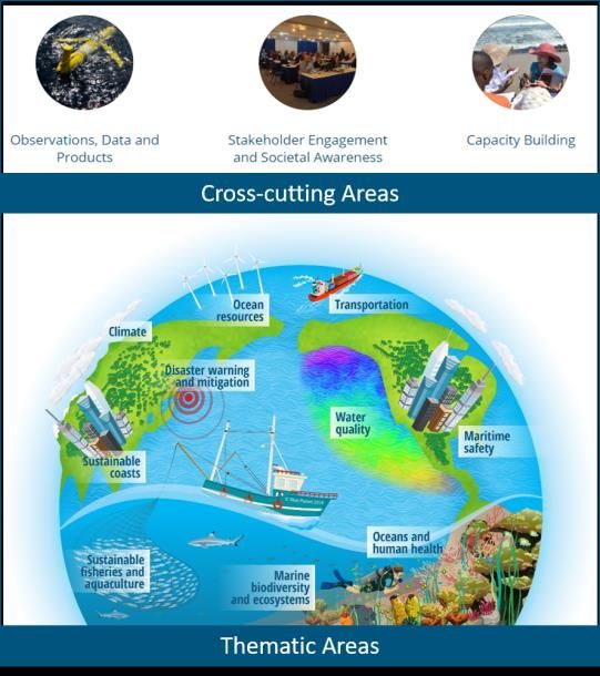
1. Executive Summary ................................................................................................................... 1
2. Purpose and Activities ................................................................................................................ 2
   Cross-cutting Activities ............................................................................................................... 4
      Stakeholder Engagement and Societal Awareness Working Group ....................................... 4
      Capacity Development Working Group .................................................................................. 7
      Data Discovery, Access and Utilization Working Group........................................................ 7
   Thematic Activities ..................................................................................................................... 9
      Understanding Flooding on Reef-lined Island Coasts Working Group .................................. 9
      Multi-hazard Information and Alert System for the Wider Caribbean Project ..................... 10
      Water-related diseases Working Group ................................................................................. 11
      Marine Debris Working Group.............................................................................................. 11
3. Background and Previous Achievements ................................................................................. 12
   Symposiums .............................................................................................................................. 12
   Workshops................................................................................................................................. 13
   Publications ............................................................................................................................... 14
4. Relationship to GEO Engagement Priorities and to other Work Programme Activities ......... 15
   GEO Engagement Priorities ...................................................................................................... 15
   Work Programme Activities...................................................................................................... 15
5. Stakeholder Engagement and Capacity Building ..................................................................... 18
6. Governance ............................................................................................................................... 18
7. Resources.................................................................................................................................. 19
8. Technical Synopsis ................................................................................................................... 19
9. Data Policy ................................................................................................................................ 20
Annex A – Acronyms and Abbreviations ..................................................................................... 22
Annex B – List of References ....................................................................................................... 24
Annex C – CV of Project Leader .................................................................................................. 28
Annex D – Terms of Reference .................................................................................................... 36

GEO Blue Planet Implementation Plan                                                                      Version 2.0 – March 2019
1 1. Executive Summary
2
3 “Oceans and Society: Blue Planet” Initiative (GEO BLUE PLANET)
4
5 Overview
6 We live on a blue planet, and Earth’s waters benefit many sectors of society. The future of our Blue
7 Planet is increasingly reliant on the services delivered by marine, coastal and inland waters and on the
8 advancement of effective, evidence- based decisions on sustainable development. GEO Blue Planet is a
9 network of ocean and coastal-observers, social scientists and end-user representatives from a variety of
10 stakeholder groups, including international and regional organizations, NGOs, national institutes,
11 universities and government agencies. GEO Blue Planet aims to ensure the sustained development and
12 use of ocean and coastal observations for the benefit of society.
13
14 GEO Blue Planet’s mission is to:
15
16 advance and exploit synergies among the many observational programmes devoted to ocean
17 and coastal waters;
18 improve engagement with a variety of stakeholders for enhancing the timeliness, quality and
19 range of services delivered; and
20 raise awareness of the societal benefits of ocean observations at the public and policy levels.
21
22 Planned Activities
23 During the 2020 – 2022 work programme period, GEO Blue Planet will work to identify and share best
24 practices on stakeholder engagement and societal awareness; communications; data discovery, access
25 and utilization; and capacity development. The initiative will collaborate with various GEO activities and
26 partners to support GEO’s engagement priorities and strengthen linkages with stakeholders. GEO Blue
27 Planet will also work to develop the below knowledge hubs and decision-support tools.
28
29 Knowledge hubs for fisheries, coral reefs and ocean-related SDG monitoring
30 Multi-hazard Information and Alert System for the Wider Caribbean
31 Early Warning System for Marine Flooding of Reef-lined Islands
32 Early-warning Systems for Water-associated Diseases
33 Systems for observing, quantifying, and classifying marine debris
34
35 Points of Contact
Name Email
Role
Steering Committee Co-Chair Paul DiGiacomo Paul.DiGiacomo@noaa.gov
Steering Committee Co-Chair Sophie Seeyave ssve@pml.ac.uk
Secretariat Lead Emily Smail Emily.Smail@noaa.gov
36
Version 2.0 (February 2019) GEO Blue Planet Implementation Plan | 137 2. Purpose and Activities
38
39 We live on a blue planet, and Earth’s waters benefit many sectors of society. The future of our blue
40 planet is increasingly reliant on the services delivered by marine and coastal waters. For example,
41 approximately 60 million people rely on fisheries and aquaculture for their livelihoods and over 80% of
42 the world’s trade is carried by sea (FAO, 2018; UNCTD, 2017). The social and economic future of these
43 and many other sectors is increasingly dependent on the services delivered by marine and coastal
44 waters. In recent years, the global community has prioritised the need for concerted action to maintain
45 these services through the agreement on the United Nations (UN) Sustainable Development Goal (SDG)
46 targeted at the oceans (SDG 14: Life Below Water) and the proclamation of a Decade of Ocean Sciences
47 for Sustainable Development (2021 – 2030) (UNESCO, 2017; UNGA, 2015). Maintenance of these
48 services relies on the advancement of effective, evidence-based decisions by governments, civil society
49 and the private sector about sustainable development, ecosystem management, food security, ocean-
50 resource utilization and natural disasters.
51
52 Evidence-based decisions in the marine realm need to be underpinned by the collection of physical,
53 chemical and biological data about coastal and open-ocean areas through direct (or “in situ”)
54 measurements and remote-sensing technologies, commonly referred to collectively as ocean and
55 coastal observations. These observations are transformed into information products, ocean forecasts
56 and services that can be used to create knowledge for effective, evidenced- based management and
57 policy decisions. For example, the implementation of the Sendai Framework for Disaster Risk Reduction
58 requires ocean observations for early warning systems to allow people to prepare and mitigate against
59 ocean-related hazards such as tsunamis, storm surges and extreme waves (Arduino et al., 2017; UNISDR,
60 2015). The ocean has significant impact on global climate patterns, and observations provide essential
61 information for forecasting precipitation and drought, the source of replenishment of water supplies,
62 and of climate events that can lead to public health incidents or changes in energy demand (Malone et
63 al., 2010; McCarthy et al., 2018; Mendez-Lazaro et al., 2014).
64
65 Coastal and ocean observations are important Essential Climate Variables (ECVs) developed in support
66 of the United Nations Framework Convention on Climate Change (UNFCCC) (GCOS, 2016). These are
67 now fully incorporated in the Global Ocean Observing System (GOOS) Framework for Ocean Observing
68 (Lindstrom et al., 2012) as Essential Ocean Variables (EOVs) that address biology, ecology, and
69 biogeochemistry in addition to physical ocean characteristics. A further complement are the Essential
70 Biodiversity Variables (EBVs) being developed by Marine Biodiversity Observation Network (MBON), a
71 theme of the GEO Biodiversity Observation Network or GEO BON (Miloslavich et al., 2018; Muller-Karger
72 et al., 2018; Navarro et al., 2017). In addition, ocean observation of these variables helps improve
73 predictions of longer-range forecasts of weather (Legler et al., 2015). Ocean biological and biodiversity
74 observations are critical in monitoring the health of and changes to ocean ecosystems, and biodiversity
75 and are required to gauge progress towards the Aichi biodiversity targets (Andrefouet et al., 2008; CBD,
76 2010, 2014; Miloslavich et al., 2017). Ocean observations are also important in managing fisheries and
77 aquaculture (Hazen et al., 2018; Saitoh et al., 2011; Solanki et al., 2015). More generally, ocean
78 information and decision support tools are needed for sustainable management of the oceans and seas
79 and a sustainable development of the blue economy.
80
Version 2.0 (February 2019) GEO Blue Planet Implementation Plan | 281 The global ocean community recognises the need for a step change in the way in which we coordinate
82 and “hardwire” the links between technological innovation and sustained observations of the oceans,
83 the data, information and services they provide, and approaches to ecologically sustainable
84 development and ocean policy. There is therefore an urgent need for the scientific community to work
85 together to leverage resources and agree on the variables that need to be measured (Essential
86 Variables) and to implement these in a systematic, sustained and globally-distributed manner
87 (Lindstrom et al., 2012). GEO Blue Planet works to address this need by bringing various ocean observing
88 organisations, programs and projects into the Group on Earth Observations System of Systems (GEOSS)
89 to work together to achieve common objectives. As stated by the European Space Agency (ESA), “What
90 is needed now, that GEOSS will help achieve, is to integrate the outputs from these various marine
91 monitoring and observation efforts into a cohesive system of systems which will enable researchers,
92 resource managers and policy makers to rapidly assess what is known about a particular marine region”
93 (Fellous & Bequignon, 2010).
94
95 GEO Blue Planet is a network of ocean and coastal-observers, social scientists and end-user
96 representatives from a variety of stakeholder groups, including international and regional organizations,
97 NGOs, national institutes, universities and government agencies. GEO Blue Planet aims to ensure the
98 sustained development and use of ocean and coastal observations for the benefit of society. In the value
99 chain of ocean and coastal observation collection, transformation and use, GEO Blue Planet focuses on
100 connecting stakeholders with available data and products, working with stakeholders to develop
101 decision support tools and identifying additional information needs.
102
103
104 GEO Blue Planet’s mission is to:
105
106 advance and exploit synergies among the many observational programmes devoted to ocean
107 and coastal waters;
108 improve engagement with a variety of stakeholders for enhancing the timeliness, quality and
109 range of services delivered; and
110 raise awareness of the societal benefits of ocean observations at the public and policy levels.
Version 2.0 (February 2019) GEO Blue Planet Implementation Plan | 3111
112 The initiative promotes, partners with and leads working groups, projects, communities and
113 programmes that support the GEO Blue Planet mission.
114 Information about GEO Blue Planet activities and related activities are organized around three cross-
115 cutting areas and ten thematic areas.
116
117
118 Planned activities for the 2020 – 2022 work programme period are summarized below.
119
120 Cross-cutting Activities
121 GEO Blue Planet has three standing working groups that implement cross-cutting activities:
122
123 Stakeholder Engagement and Societal Awareness Working Group
124 Capacity Development Working Group
125 Data Discovery, Access and Utilization Working Group
126
127 The primary role of these working groups is to identify and share best practices. A core group of working
128 group members identify and guide priority activities. Task Teams with additional members from the GEO
129 Blue Planet Steering Committee and other interested parties are formed to implement short-term
130 activities (6 - 18 months).
131
132 Stakeholder Engagement and Societal Awareness Working Group
133 The GEO Blue Planet working group on stakeholders and societal awareness works to promote
134 communication between those who need better knowledge of the ocean and coasts with those who are
Version 2.0 (February 2019) GEO Blue Planet Implementation Plan | 4135 capable of producing that knowledge using ocean and coastal observation technologies. The current and
136 planned activities of this working group are outlined below.
137
138 Stakeholder Engagement Activities in Support of Sustainable Development
139 Ensuring the sustainability of our oceans, coastal environments and coastal communities requires
140 international collaboration. This is even more evident as we must consider the monitoring and reporting
141 of ocean ecosystems which are beyond national (agreed or not) jurisdiction (i.e. Exclusive Economic
142 Zone waters). The GEO Blue Planet initiative intends to provide mechanisms and opportunities to make
143 Earth Observation technologies and data more useful for the achievement of the United Nations SDGs,
144 The Sendai Framework for Disaster Risk Reduction, and the Paris Climate Agreement.
145
146 GEO Blue Planet currently has a task team working to support the United Nations Environment
147 Programme on the methodology development of SDG 14.1.1 (Index of coastal eutrophication and
148 floating plastic debris density). This task team provides UN Environment with information about existing
149 data and methods for monitoring coastal eutrophication and marine debris and provides. The team also
150 provides networking support to link Earth Observation experts with relevant stakeholders.
151 Additional task teams will be formed to support the custodian agencies of SDG 14 and to support
152 stakeholder ocean and coastal observation needs for the 16 other SDGs, the Sendai Framework for
153 Disaster Risk Reduction and the Paris Climate Agreement.
154
155 Organizing regional and thematic workshops aimed at identifying and articulating ocean and coastal
156 information needs and stakeholder priorities
157 Understanding the decisions stakeholders are required to make and what information is required to
158 support those decisions is a key focus of GEO Blue Planet. GEO Blue Planet works to plan regional
159 workshops that bring together representatives of government, research institutions, industry and NGOs,
160 to assess the local needs in terms of ocean and coastal observation-based products and services, as well
161 as the capacity development required for the use, as well as the development/hosting/maintenance of
162 such services. GEO Blue Planet also makes understanding information needs and stakeholder priorities a
163 focus of international GEO Blue Planet symposiums. These symposiums are held every one to two years
164 in different regions. Previous symposiums have taken place in Brazil, Australia, the United States and
165 France. Upcoming symposiums will be held in 2020 and 2022 in locations to be determined.
166
167 Compiling examples of societal benefits achieved from ocean and coastal observations
168 The ocean is generally not recognized by large portions of the world’s population as being a priority,
169 despite being a major source of food, transport and recreation, a large contributor to the global
170 economy, supporting a significant proportion of the global population. Many social and economic
171 processes on land are impacting the ocean severely (for example, the flows of nutrients, plastics, and
172 chemical pollutants into the ocean, and the increased absorption of atmospheric carbon dioxide) while
173 awareness of these impacts is generally very low. If people are not aware of the importance, as well as
174 the vulnerabilities, of the ocean, they are even less likely to understand the impacts that ocean
175 observations can have (and do have) on their everyday lives and how their actions impact the ocean.
176 The GEO Blue Planet working group on stakeholder engagement and societal awareness works to
177 explain, in simple and meaningful terms, to a lay audience, what ocean observations are, what types of
178 products and services can be derived from them, and how they are essential for the health, wealth and
179 well-being of humankind and the sustainability of our global civilization.
Version 2.0 (February 2019) GEO Blue Planet Implementation Plan | 5180 The working group formed a task team to compile some iconic examples of ocean observing products
181 that have a direct and tangible positive impact on society, e.g. saving lives, supporting livelihoods,
182 producing economy benefits, etc.
183
184 Developing and sharing of co-development of decision support tools based on ocean and coastal
185 observations
186 The GEO Blue Planet initiative recognizes the importance and value of engaging with all institutions that
187 play a role in converting ocean and coastal observations to meet the information needs of communities
188 and stakeholders. After decades of Earth observation development, there is a realization of the
189 importance of meeting these needs in terms of societal benefit and sustainable development.
190 Information that is co-produced with scientists and stakeholders has been demonstrated to lead to
191 more concrete and effective outputs (Howarth & Monasterolo, 2017; Kirchhoff et al., 2013; Lemos &
192 Morehouse, 2005; Reed et al., 2014; Roux et al., 2010; Walter et al., 2007). The stakeholder engagement
193 and societal awareness working group works to share best practices for stakeholder engagement and
194 co-develop decision support tools in order to support beneficial changes in policy and behavior.
195
196 Mapping the ocean and coastal observation and services “oceanscape”
197 There is a clear need to make existing services more easily discoverable and usable by non-specialists.
198 Governments and industry are simply not aware of much of what the ocean observing community is
199 doing and how it can be used for societal benefit. Part of the issue is the apparent lack of clarity on who
200 is doing what and how all the organisations fit together, as highlighted and discussed at both the Kick-
201 Off and 2nd Blue Planet Symposia. During the 3rd Blue Planet Symposium, there was very strong
202 support for the idea that Blue Planet would work on producing a diagram that would provide some
203 clarity on which organisations are doing what in relation to ocean observing (e.g. capacity building, data
204 management, coordination of observations, user engagement etc) (GEO Blue Planet, 2017). Because it is
205 such a complex field, it was agreed that an interactive web-based system would be most appropriate.
206 This would allow each organization to be tagged with various criteria (e.g. global/regional,
207 intergovernmental/NGO, etc) for greater clarity in presentation. It was also noted that a simplified
208 version would be needed to reach decision makers and other people outside the field. A prototype has
209 been developed by GEO Blue Planet, which will be launched and further refined during the 2020-22
210 implementation phase. In particular, during 2020-22 products and services will be added to the
211 database, which is currently focusing only on organisations.
212
213 Best practices in science communication and outreach
214 This aspect of the Blue Planet Working Group is led by “Ocean Communicators United”, an informal
215 grouping of representatives of international, regional or national oceanographic research organisations
216 that provides a forum for its members to share information, expertise, best practices and materials
217 related to marine science communications. The current and planned activities of this group are outlined
218 below.
219
220 Maintain and share a distribution list of communications points of contact for marine research
221 institutes and international organisations
222 Share communications products via e-mail, social media and alongside relevant international
223 conferences and events
224 Have quarterly on-line meetings to discuss science communication topics
Version 2.0 (February 2019) GEO Blue Planet Implementation Plan | 6225 Work collectively to develop best practices in science communication and outreach
226 Support communications projects including communications for the UN Decade of Ocean
227 Science for Sustainable Development (2021-2030)
228
229 Capacity Development Working Group
230 The GEO Blue Planet working group on capacity development works to link and build on existing
231 capacity development efforts related to sustained ocean and coastal observations, products and
232 services. Best practices will be shared broadly with the GEO Blue Planet and broader GEO community,
233 and in particular submitted to IODE Ocean Best Practices repository (www.oceanbestpractices.org). The
234 current and planned activities of this working group are outlined below.
235
236 Compiling and summarizing best practices for evaluating the impact of capacity building programmes
237 A task team on best practices in capacity building is being formed and will work closely with the GEO
238 Task Team on Capacity Building and the Committee on Earth Observation Satellites (CEOS) Working
239 Group on Capacity Building and Data Democracy, and other groups as relevant, to share information
240 with the GEO community at large and leverage existing efforts. The leads of the GEO and CEOS groups
241 will be invited to participate, and/or act as liaisons with the GEO Blue Planet task team.
242
243 This task team will discuss best practices in evaluating the impact of capacity development programmes.
244 The Partnership for the Observation of the Global Ocean (POGO) and The Scientific Committee on
245 Oceanic Research (SCOR), who have worked together on this in the last 2 years, will provide their
246 insights and invite other organisations to contribute theirs, with a view to compiling best practices in
247 both:
248
249 How to conduct such an evaluation (surveys, testimonials, metrics…),
250 How to analyse and interpret the results (e.g. what recommendations can be drawn on
251 how to improve programmes or how to select the best type of programme to meet a
252 particular need or requirement).
253
254 Assessment of capacity development needs of developing countries
255 The working group plans to subsequently form a task team to assessing the capacity building needs of
256 developing countries. IODE has done some work in this area and could share their experience and
257 methods. SERVIR, a joint venture between NASA and the U.S. Agency for International Development,
258 which has been running for the last 10 years, has developed some guidelines on the full planning cycle,
259 from scoping user requirements to engagement and evaluation.
260
261 Data Discovery, Access and Utilization Working Group
262 The GEO Blue Planet working group data discover, access and utilization is working to share best
263 practices and support activities to increase data discoverability and integration of data sets. The working
264 group is particularly focused on supporting the advent of systematic and regular provision of analysis
265 ready quality assured data. The current and planned activities of this working group are outlined below.
266
267 Networking existing regional and international efforts in improving data interoperability and access
268 Significant investment has been made by some nations in a range of ocean data, modeling and analysis
269 at regional, national and global scales. Despite the growing number of datasets and data portals,
Version 2.0 (February 2019) GEO Blue Planet Implementation Plan | 7270 stakeholders continue to express that data access, discovery and use remains a challenge (CSIRO, 2018;
271 Plag & the workshop participants, 2018; Scarrott et al., 2018).
272
273 GEO Blue Planet works with data providers to increase data discoverability and integration of data sets
274 including traditional geospatial data (e.g., management boundaries), time series monitoring data (e.g.,
275 coastal and ocean moorings), gridded datasets (e.g., satellite remote sensing products) and complex
276 multi-dimensional data cubes (e.g., ocean models). GEO Blue Planet is particularly focused on supporting
277 the advent of systematic and regular provision of analysis ready quality assured data. A primary way this
278 will be accomplished during the work programme period is through support for the development of and
279 contribution to IODE’s Ocean Best Practices System.
280
281 In addition, GEO Blue Planet will examine the development of Data Cubes and Analysis Ready Datasets
282 (ARDs) to see how these may be applied to the ocean and coastal domain. Recognising the potential of
283 Data Cubes as initiatives to increase the value and use of satellite data by providing users with access to
284 free and open data management technologies and analysis platforms, and considering that Data Cubes
285 have been currently focused for land and in-land water applications, GEO Blue Planet will look to assess
286 the feasibility of building Data Cubes for ocean and coastal applications.
287
288 Working with data providers to generate knowledge hubs for data and products
289 GEO Blue Planet works to support the use of Earth observation data to enable decisions based on
290 actionable knowledge. We need to understand the state of our planet and thereafter be able to take
291 informed decisions on how best to make use of our resources. Within this context, the knowledge we
292 enable must be reliable, robust and replicable. The low entry costs associated to the analysis of very
293 large Earth observation datasets has redefined the traditional paradigm through which users have been
294 accessing data. In addition, programmes such as Copernicus, are paving the way to a democratisation of
295 access to Earth observation data.
296
297 GEO Blue Planet is ready to take stock of this new environment and invest in co-designing and co-
298 producing Earth observation-based services for different set of communities, at different scales. Within
299 the next reporting period Blue Planet will seek funds to co-build ocean-related “knowledge hubs” for
300 fisheries, coral reefs and SDG monitoring.
301
302 Fisheries: There is a need to share existing fisheries resources and collect/integrate new in-
303 situ data: this include fish species, human resources impacting the fishery, as well as other
304 aspects related to artisanal fisheries. This is required to understand the status of resources
305 and exploitation rate and would allow stakeholders in various regions to develop plans and
306 sustainable management practices. Some species are endangered and vulnerable, while
307 some invasive species have been biologically and/or economically affecting some other fish
308 resources in some regions due to climate change, migration and illegal dislodging of ballast
309 waters. GEO Blue Planet will work with countries to identify the needs and the gaps in data
310 availability and knowledge sharing for the fisheries community across local, regional and
311 global level and scale of type of fisheries (capture fishery- artisanal, commercial;
312 aquaculture- inland, coastal and offshore fish farming; species type brackish; socio economic
313 aspect), and support the implementation of an open knowledge platform to empower
314 decision makers.
Version 2.0 (February 2019) GEO Blue Planet Implementation Plan | 8315 Coral reefs: While there are several existing Coral Reef monitoring information systems (e.g.
316 the NOAA Coral Reef Information System (CoRIS) and CSIRO-eReefs System), data collected
317 by researchers and NGOs are often not easily located or shared. GEO Blue Planet will work
318 to increase the discovery and accessibility of available data worldwide and encourage the
319 registration of data in shared platforms.
320 SDG monitoring: Any national SDG implementation will be sub-optimal without strategies
321 and frameworks to integrate statistics, geospatial information, earth and ocean
322 observations, and other new data into the measuring, monitoring and reporting processes.
323 Currently a large percentage of ocean related SDG indicators are still Tier III, i.e. have no
324 established methodology and standards or methodology/standards are being
325 developed/tested. Countries are demanding more data, and the ocean observation
326 community needs to work on mechanisms and solutions to facilitate the delivery of long-
327 term data and information. The challenge is to increase significantly the availability of high-
328 quality, timely and reliable disaggregated data. GEO Blue Planet will work with countries and
329 custodian agencies to enable the transition of ocean related SDG indicators from Tier III and
330 will support the co-design and co-production of new data products through an open
331 knowledge platform.
332
333 Thematic Activities
334 GEO Blue Planet welcomes proposals for thematic activities that address one of GEO Blue Planet’s
335 themes. Current thematic activities include:
336
337 Understanding Flooding on Reef-lined Island Coasts Working Group
338 Multi-hazard Information and Alert System for the Wider Caribbean Project
339 Water-associated Diseases Working Group
340
341 Understanding Flooding on Reef-lined Island Coasts Working Group
342 The Understanding Flooding on Reef-lined Island Coasts (UFORIC) Working Group works to develop
343 action plans that can be used globally, regionally, and nationally to help guide research and
344 development activities related to understanding and predicting flooding along tropical coral reef-lined
345 shorelines over the coming years.
346
347 Major focus areas of the Working Group
348
349 1. The need for early-warning systems to provide short-term forecasts of flooding on the order
350 of days. Short-term forecasts are dominated by tides, wind-waves, local wave set-up, and
351 barometric pressure. The goal is for disaster risk reduction by reducing risk to life and assets
352 by providing a warning to increase preparedness or allow for evacuation.
353 2. The greatest needs to develop early-warning systems include: coral reef bathymetry and
354 island topography; in situ wave, water level, and flooding observations to calibrate and
355 validate numerical models of wave-driven flooding over coral reefs; and the study of records
356 from past flooding events to define local event thresholds.
357 3. The need for future scenarios of flooding focused on the timeframe of decades, starting in a
358 few decades. Long-term projections are primarily governed by sea-level rise, wind and wave
359 climates, coral reef biogeomorphology and sediment budgets, and anthropogenic impacts.
Version 2.0 (February 2019) GEO Blue Planet Implementation Plan | 9360 The goal is to provide guidance to prioritize planning to mitigate or adapt to forecasted
361 impacts and thus increase the resiliency of coastal communities.
362 4. The greatest needs to develop future projections include: downscaled pressure and wind
363 fields for more accurate future wave modeling; historic coastal change data, especially
364 island vertical development; carbonate sediment budgets; and coral reef and island coring
365 to understand how they have evolved over recent changes in sea level.
366
367 Early Warning System for Flooding of Reef-lined Islands
368 The UFORIC Working Group is working on a project to develop an Early Warning System for Wave-driven
369 Flooding of Reef-lined Coasts. The project aims to develop a simplified Early Warning System (EWS) that
370 covers all coral-reef lined coasts in the world and provides a wave-driven flood forecast out to 7 days.
371 This initial EWS would be able to forecast wave-driven flooding events in general terms, picking up the
372 larger events well, but likely missing some smaller events.
373
374 The Working Group expects that they will be ready to begin implementing the EWS globally by 2020 and
375 a fully implemented version 1 of the EWS will be running in experimental mode within two to three
376 years of the beginning of the rollout, with a fully working version 1.1 of the EWS to be running
377 throughout the world within 5 years of the start of the global rollout (note that funding for the global
378 rollout is yet to be identified). The initial EWS would be useful for flood forecasting and will serve as a
379 basis for further refinement of the global EWS and as a useful framework within which much higher
380 resolution flood models can be developed. It will also serve to help scientists understand the relative
381 importance/sensitivities of the various components of marine flooding models/products. This will assist
382 scientists as they seek to develop more sophisticated and detailed models and products.
383
384 Initially, the project will utilize existing satellite and modelled wave and sea surface height products and
385 outputs, combining them with existing bathymetry with significantly simplified assumptions about
386 friction coefficients, shallow water bathymetry profiles, wave direction, beach morphology, etc. The
387 result should be an EWS that works but will have significant room for improvement.
388
389 Multi-hazard Information and Alert System for the Wider Caribbean Project
390 In recent years, the Caribbean region has faced challenges from oil spills and an influx of floating
391 sargassum seaweed. Large-scale oil spill incidents have included an April 2017 spill at Pointe-à-Pierre,
392 Trinidad and Tobago and a July 2017 oil spill in Kingston Harbor, Jamaica. Illegal dumping of oil-
393 contaminated waste by ships operating in the region is also a common occurrence. An increase in the
394 frequency and volume of sargassum beachings and coastal overabundance has caused another
395 challenge for the region with mats preventing the deployment and retrieval of fishing gear and clogging
396 popular beaches, harbors and bays.
397
398 The Intergovernmental Oceanographic Commission of UNESCO (IOC-UNESCO)’s Sub-Commission for the
399 Caribbean and Adjacent Region (IOCARIBE), its GOOS Regional Alliance IOCARIBE-GOOS and GEO Blue
400 Planet are working with partner organizations and stakeholders to develop a multi-hazard information
401 system for the Caribbean and Adjacent Regions. The project will first focus on sargassum and oil spills
402 and expand to include additional hazards as identified by local stakeholders.
403
Version 2.0 (February 2019) GEO Blue Planet Implementation Plan | 10404 The objective of the information service will be to provide a publicly available monitoring platform and
405 alerting system for oil spills and sargassum based on publically available data (e.g. satellite data and in
406 situ data from countries with open data sharing policies). The service will initially be based on existing
407 technologies and activities, working to augment and improve the framework for information
408 management and delivery and mechanisms for the region and demonstrate the utility of ocean
409 observations and products.
410
411 The project will be implemented in two phases with Phase I (2018 – 2019) and phase two corresponding
412 to year (2020 – 2021). See the attached implementation plan tables for additional details on
413 deliverables.
414
415 Water-related diseases Working Group
416 Several million cases of water-associated disease are reported globally each year from water-borne or
417 vector-borne pathogens. A large number of cases may be avoided through improved access to clean
418 water and sanitation, and more cases could be prevented by improving prediction of disease outbreaks
419 and health risks, using an integrated approach involving in-situ observations, laboratory experiments,
420 remote sensing and modelling.
421
422 The GEO Blue Planet Working Group on Earth Observations for Water-Associated diseases aims to
423 identify benefits, best practices and feasibility of incorporating Earth observation measurements into
424 early-warning systems for water-associated diseases. It provides a forum to exchange useful
425 information, share data and coordinate activities where feasible, to maximise benefits to society.
426
427 The Working Group engages with specialists in the fields of ecology, epidemiology, bioinformatics,
428 genetics, remote-sensing, modelling, climate, limnology and oceanography, and is linking with end-
429 users, including local communities, governments, health services, intergovernmental organisations, and
430 policy makers.
431
432 This initiative has been recognised as an important GEO Blue Planet activity under Theme 2 ‘Healthy
433 Ecosystems and Food Security’, and with societal relevance to public health, food security, water
434 management, biodiversity and ecosystem sustainability, and disaster resilience. The WG activities are
435 further adding value to GEO health community of practice and AquaWatch initiatives.
436
437 The Working Group Scoping Meeting was held in Abingdon, Oxfordshire, UK, on 30 and 31 August 2018.
438 During the meeting, the participants agreed to the formation of the WG. Related activities are available
439 at: https://geoblueplanet.org/blue-planet-activities/wg_eo_water-associated_diseases/.
440
441 Marine Debris Working Group
442 GEO Blue Planet, together with partner organizations, is bringing together a collaboration working
443 group focusing on the mounting global challenge of plastic pollution (Law & Annual, 2017; Nash, 1992;
444 Peeken et al., 2018; Schmidt et al., 2017; Villarrubia-Gomez et al., 2018) impacting the marine
445 biosphere (Green et al., 2019; Katz, 2018; Nel et al., 2017; Taylor et al., 2016) and the foodweb (e.g.,
446 (Provencher et al., 2018). There is a need for an international agreement on plastic pollution (Borrelle
447 et al., 2017), and the development of such an agreement needs to be informed by Earth observations.
448 Efforts to monitor and quantify the flow of plastics into the ocean and detect ocean plastics are
Version 2.0 (February 2019) GEO Blue Planet Implementation Plan | 11449 evolving (e.g., (Davaasuren et al., 2018; Garaba & Dierssen, 2018). A workshop held on November 26-
450 27, 2018 in Brest, France (see http://www.gstss.org/2018_Brest) brought together a wide range of
451 societal agents engaged in ocean plastic pollution to initiate the collaboration WG.
452
453 More generally, a growing amount of marine debris challenges the health of the ocean. Recent
454 disasters like the 2011 tsunami in Japan (e.g., (Murray et al., 2018) and the 2018 Hurricane Michael
455 create a large amount of debris that is swept into the ocean, which adds to the continuous flow of
456 debris from ocean traffic and rivers. Observing, quantifying, and classifying marine debris are activities
457 that urgently need to be coordinated and extended to ensure that societal stakeholders engaged in
458 reducing this threat to ocean health have the evidence to base decisions and policy on. The Working
459 Group will initially focus on marine plastic pollution and then extend this to include all marine debris.
460
461 3. Background and Previous Achievements
462
463 The creation of the “Oceans and Society: Blue Planet” Task was an initiative of POGO in 2011, to
464 coordinate all the existing ocean observation programmes within GEO, to add new ones to the GEO
465 portfolio, and to create synergies between them. GEO Blue Planet was introduced formally into the GEO
466 work programme in 2012 (as SB:01) (GEO, 2014). The GEO Blue Planet Secretariat was established in late
467 2015 by the U.S. National Oceanic and Atmospheric Administration (NOAA) leading to GEO Blue Planet
468 being incorporated in the GEO work programme as an initiative in 2017 (GEO, 2017).
469
470 In 2017, GEO Blue Planet created a formal Steering Committee and Advisory Board composed of ocean
471 and coastal-observers, social scientists and end-user representatives from a variety of stakeholder
472 groups, including international and regional organizations, NGOs, national institutes, universities and
473 government agencies. GEO Blue Planet has also established a web presence (see:
474 www.geoblueplanet.org and @GEOBluePlanet on Twitter). Working groups have been established as
475 outlined above and the development of decision support tools and data services is underway.
476
477 Through the efforts of Steering Committee, Advisory Board, Working Groups and Secretariat, GEO Blue
478 Planet has been working to provide a networking service to the ocean and coastal observing community
479 and other stakeholders. These efforts include supporting the development of partnerships and sharing
480 of information. Though difficult to quantify, this service has played an important role and is
481 recommended as a key focus for the initiative to play moving forward (GEO Blue Planet, 2017, 2018).
482
483 Major events and publications that have been supported by GEO Blue Planet in recent years are
484 summarized below.
485
486 Symposiums
487 GEO Blue Planet hosts symposiums every one to two years in different regions for the purpose of
488 increasing regional linkages, promoting linkages between stakeholders and the observing community
489 and gathering community feedback on the focus of GEO Blue Planet activities.
490
491 Kick-off Symposium - Ilhabela, Brazil, 2012
Version 2.0 (February 2019) GEO Blue Planet Implementation Plan | 12492 A kick-off symposium for the new GEO marine Task SB-01 “Oceans and Society: the Blue Planet” was
493 held in Ilhabela, São Paulo State, Brazil, from November 19 to 21, 2012. The symposium was co-
494 sponsored by the Canadian Space Agency (CSA), GEO, Brazil’s National Institute for Space Research
495 (INPE) and POGO and took place just prior to the GEO-IX Plenary, held in Foz do Iguaçu, Brazil
496 (November 22 and 23, 2012).
497
498 2nd GEO Blue Planet Symposium – Cairns, Australia, 2015
499 The second Blue Planet symposium for the GEO marine Task SB-01 “Oceans and Society: the Blue
500 Planet” was held in Cairns, Australia from 27 to 29 May 2015. The symposium was co-organised by
501 CSIRO and POGO.
502
503 3rd GEO Blue Planet Symposium – College Park, MD, USA, 2017
504 The 3rd Blue Planet Symposium was held in College Park, Maryland, USA from 31 May to 2 June 2017.
505 The symposium was co-hosted by the National Oceanic and Atmospheric Administration, the University
506 of Maryland and the University System of Maryland Foundation.
507
508 4th GEO Blue Planet Symposium – Toulouse, France, 2018
509 The 4th GEO Blue Planet Symposium was held from July 4 – 6, 2018 in Toulouse, France. The symposium
510 was hosted by Mercator Ocean, member of the GEO Blue Planet Initiative and entrusted by the
511 European Commission to operate the EU Copernicus Marine Service. This was the largest symposium to
512 date with attendance of 300 delegates from international organisations and networks, research
513 scientists, government agencies, various industries, ocean science communicators and graduate
514 students.
515
516 Workshops
517 GEO Blue Planet works with various partners to organize workshops that aim to identify stakeholder
518 information needs, support the development of decision-support tools and identify technology and data
519 gaps.
520
521 Workshop on Implementing and Monitoring the Sustainable Development Goals in the Caribbean:
522 The Role of the Ocean – St. Vincent and the Grenadines, 2018
523 This workshop, funded by NASA, was organized as a collaborative effort of GEO Initiatives, governments
524 of the Caribbean SIDS, United Nations Agencies, and regional non-governmental organisations. It
525 brought together 42 participants from sixteen countries.
526
527 Workshop on Understanding Flooding on Reef-lined Island Coasts – Honolulu, HI, USA, 2018
528 This workshop brought together about 30 experts were brought together from around the globe to
529 foster collaboration and assess the state of knowledge of the different factors that control the spatial
530 extent, timing, frequency, and magnitude of coastal flooding along tropical coral reef-lined coasts. The
531 workshop was supported by the United States Geological Survey (USGS) and NOAA and run in
532 collaboration with Deltares and CSIRO.
533
534 Workshop on Sargassum and Oil Spills Monitoring for the Caribbean Sea & Adjacent Regions – Mexico
535 City, Mexico, 2018
Version 2.0 (February 2019) GEO Blue Planet Implementation Plan | 13536 This workshop was organized by IOCARIBE of IOC UNESCO and its Global Ocean Observing System
537 Regional Alliance, IOCARIBE-GOOS, and the GEO Blue Planet Initiative, and hosted by the Ministry of
538 Education of Mexico and Mexico National Council of Sciences. The workshop brought together 40
539 experts from 15 countries to discuss sargassum and oil spill monitoring in the Caribbean and Adjacent
540 regions.
541
542 Workshop on Technologies for Observing and Monitoring Plastics in the Oceans – Brest, France, 2018
543 The workshop brought together social agents engaged in assessing and reducing the impacts of plastics
544 in the ocean with experts assessing the sources of plastics in the ocean and scientists and developers
545 focusing on existing and new observation technologies to detect and quantify plastics in the ocean. The
546 workshop was supported by the IEEE Oceanic Engineering Society.
547
548 Publications
549 S. Djavidnia, V. Cheung, M. Ott and S. Seeyave, Eds., “Blue Planet: Oceans and Society,” Cambridge
550 Scholars Publishing, Newcastle upon Tyne, United Kingdom, 2014. URL:
551 http://www.cambridgescholars.com/oceans-and-society
552
553 GEO Blue Planet (in press). Ocean Observing for Societal Benefit. Journal of Operational Oceanography
554 Supplemental issue.
555
556 B. Mackenzie, L. Celliers, L. Paulo de Freitas Assad, J.J. Heymans, C. Anderson, J. Behrens, M. Calverley,
557 K. Desai, P. DiGiacomo, S. Djavidnia, F. dos Santos, D. Eparkhina, J. Ferrari, C. Hanley, B. Houtman, G.
558 Jeans, L. Landau, K. Larkin, D. Legler, P.Y. Le Traon, E.J. Lindstrom, D. Loosley, G. Nolan, G. Petihakis, J.
559 Pellegrini, N. Rome, Z. Roberts, J. Siddorn, E.A. Smail, I. Sousa-Pinto, E. Terrill and J.O. Thomas.
560 (Manuscript submitted for publication). The role of stakeholders and actors in creating societal value
561 from coastal and ocean observations. Frontiers in Marine Science.
562
563 L. Celliers, L. Lorenzoni, M. Máñez Costa, K. Isensee, K. Schoo, E.A. Smail and C. Teichmann. (Manuscript
564 submitted for publication). Ocean Observations to Underpin Policy: Examples of Ocean Observations in
565 Support of the Sendai Framework, UNFCCC, and Sustainable Development Goal 14. In A. Kavvada and D.
566 Cripe (Eds.), Earth Observation Applications and Global Policy Frameworks. Washington, DC: American
567 Geophysical Union.
568
569 S. Seeyave, P. Simpson, S. Burg, K.M. Davidson, T. Keizer, F. Beckman, V. Cheung, A. Miller, A. Ribeiro, E.
570 Smail and A. Villwock (2017). Writing a Communication Strategy: A Step-by-Step Guide and Template,
571 Tailored for International (Marine) Science Organisations. URL:
572 https://www.oceandocs.org/bitstream/handle/1834/10736/OCU%20Communications%20Strategy%20
573 Guide_2017.pdf?sequence=1&isAllowed=y
574
575 GEO Blue Planet (2018). What can the ocean tell us? Why ocean observation products and services are
576 vital for us and our planet. URL: https://3iiz1x2nd4vl3b8ewe4frxdf-wpengine.netdna-ssl.com/wp-
577 content/uploads/2018/05/Blue-Planet-Ocean-Observation-brochure-221217-WEB.pdf
578
Version 2.0 (February 2019) GEO Blue Planet Implementation Plan | 14579 4. Relationship to GEO Engagement Priorities and to other Work Programme
580 Activities
581
582 GEO Engagement Priorities
583 GEO’s global priorities include supporting the UN 2030 Agenda for Sustainable Development, the Paris
584 Climate Agreement, and the Sendai Framework for Disaster Risk Reduction.
585
586 UN 2030 Agenda for Sustainable Development
587 GEO Blue Planet works to engage with users and identify priority information needs to achieve
588 sustainable development priorities. For SDG monitoring and reporting, GEO Blue Planet focuses on
589 supporting custodian agencies with the development of methodologies and to identify sources of data
590 and develop display interfaces for SDG 14 (life below water).
591
592 The Paris Climate Agreement
593 GEO Blue Planet will work in collaboration with the GEO Carbon and Greenhouse Gas (GHG) Initiative to
594 support and promote their activities related to oceans and coasts including the impacts of sea level rise
595 and ocean acidification.
596
597 The Sendai Framework for Disaster Risk Reduction
598 GEO Blue Planet works to support the development of early warning systems for the management of
599 disasters related to ocean and coastal impacts. These efforts include the early warning system for
600 marine flooding in reef-lined islands and the multi-hazard information and alert system for the wider
601 Caribbean. GEO Blue Planet will work to develop these activities and collaborate with the Data Access
602 for Risk Management (GEO DARMA) Initiative on projects over the course of the 2020 – 2022 work
603 programme period.
604
605 Work Programme Activities
606 GEO Blue Planet works to develop and support partnerships with other GEO Work Programme Activities.
607 The primary GEO partners for GEO Blue Planet are outlined below. GEO Blue Planet will work to
608 strengthen linkages with these GEO activities and develop new collaborations over the course of the
609 2020 – 2022 work programme period.
610
611 GEO BON
612 The Marine Biodiversity Network (MBON) of the GEO Biodiversity Observation Network (GEO BON) is
613 GEO Blue Planet’s key partner on biodiversity related activities. GEO Blue Planet collaborates with
614 MBON on regional and thematic workshops and projects that are of mutual interest. GEO Blue Planet
615 supports the MBON Seascapes program through the NOAA CoastWatch program and will work to
616 support the development and implementation of the MBON Pole-to-Pole project activities moving
617 forward. GEO Blue Planet also works to help connect the MBON community to resource management
618 practitioners and to policy makers that can define their requirements for Essential Ocean Variables
619 (EOVs) and Essential Biodiversity Variables (EBVs) (see Miloslavich et al., 2018; Muller-Karger et al.,
620 2018). MBON supports biodiversity linkages between GEO Blue Planet and several programs of the
621 Intergovernmental Oceanographic Commission of UNESCO, including the Global Ocean Observing
Version 2.0 (February 2019) GEO Blue Planet Implementation Plan | 15622 System (GOOS), the Ocean Best Practices System (OBPS), and the Ocean Biogeographic Information
623 System (OBIS).
624
625 MBON Seascapes Project
626 The MBON Seascapes project was funded by NASA under the call for support for GEO activities (PI:
627 Maria Kavanaugh, Oregon State University). This project seeks to identify coherent spatial and temporal
628 patterns in surface ocean conditions that may occur repeatedly in the world’s oceans. The classifications
629 define ‘seascapes’ as an ecological parallel to terrestrial ‘landscapes’. The project characterizes the
630 extent to which seascapes are dynamic on seasonal and interannual temporal scales and over multiple
631 spatial scales. They will be identified using model and satellite remote sensing data that are updated
632 regularly and time series that provide a historical context for reference against which to measure
633 change. Scale, context-dependency, and shifting geographies make it difficult for managers and policy
634 makers to assess baselines against which to measure change in marine ecosystems. Measuring changes
635 in habitats is fundamental to understand multiple stressors on pelagic ecosystems. Yet it is difficult to
636 visualize and understand how different environmental variables interact to define conditions suitable for
637 one group of organisms or another, or how the distribution and abundance of life may change given
638 changes in environmental or biological drivers. Indeed, defining ways to assess marine biodiversity is
639 important to evaluate ocean health and ecosystem services. This project uses Earth Observations to
640 visualize, track, and analyze changes in marine habitats and provide the information to stakeholders in a
641 way that is helpful to address marine conservation and sustainable use.
642
643 GEO Blue Planet will work to support this effort over the 2020 – 2022 work programme period by
644 supporting efforts to detect and track changes in marine habitats, including impacts on, for example,
645 benthic communities due to changes in the surface ocean.
646
647 GEO AquaWatch
648 GEO AquaWatch serves as GEO Blue Planet’s partner on water quality issues. Water quality information
649 is required for several of GEO Blue Planet’s projects including support for SDG 14.1.1 (Index of coastal
650 eutrophication and floating plastic debris density) and the work of the water-associated diseases
651 working group.
652
653 GEO Heath Community of Practice
654 The GEO Health Community of Practice is a partner of GEO Blue Planet’s working group on water-
655 associated diseases. GEO Blue Planet seeks to expand collaborations with the GEO Health Community of
656 Practice over the 2020 – 2022 work programme period including those related to pollution and coastal
657 hazards.
658
659 GEO ECO
660 The GEO Global Ecosystem Initiative (GEO ECO) leads a complementary effort, in collaboration with
661 international marine scientists to produce a map of global ecological marine units (EMUs) from a 57 year
662 record of temperature, salinity, dissolved oxygen, and nutrients data. The EMUs partition the global
663 ocean into 37 physically and chemically distinct volumetric ocean regions. While the 1/4° (~27 km)
664 spatial resolution of the EMUs is appropriate for mapping distinct open ocean regions, the satellite
665 remote sensing seascapes provide a much finer spatial resolution for the classification and delineation of
666 surface ocean ecosystems. Even finer spatial resolution is needed for coastal ecosystems because they
Version 2.0 (February 2019) GEO Blue Planet Implementation Plan | 16667 represent the true land/water interface, often exist as small and linear features, and are often densely
668 populated. An effort to delineate a new set of global Ecological Coastal Units (ECUs) was initiated as a
669 partnership between Esri, USGS, MBON, and individuals representing international government,
670 academic, and NGO organizations (Sayre et al., 2018). The roles of the three leading participating
671 organizations are as follows: USGS provides scientific leadership, coordination, and liaison with the
672 Group on Earth Observations (GEO); Esri is the primary implementing entity, and provides both scientific
673 and technical leadership as well as tool development and data dissemination; MBON is a commissioning
674 entity and represents both a stakeholder community and pool of subject matter expertise. Individuals
675 from a host of government, academic, and NGO organizations comprise an experts Steering Committee
676 for the ECU development process. The commission, constitution, governance, and operation of the
677 partnership is described, along with a description of the methodological approach to delineate the ECUs.
678
679 The initial GEO ECO work to produce the standardized ecological coastal units has resulted in a new
680 online data discovery and exploration tool called the Global Island Explorer (GIE -
681 https://rmgsc.cr.usgs.gov/gie/). This tool allows anyone with an internet connection to visualize and
682 query ~ 340,000 islands and their shorelines at a very high spatial resolution (30 m). Recognizing the
683 value of the data for the ocean science and policy community, GEO Blue Planet invited publication of the
684 global islands and shorelines work in a GEO Blue Planet special issue publication in the Journal of
685 Operational Oceanography (Sayre et al., 2018). GEO Blue Planet is recognized as a partner in the GIE
686 development through logo inclusion on the welcome page. Going forward, Blue Planet intends to
687 continue exposing and promoting the work to the larger ocean science and policy community. The
688 EMUs, ECUs, Global Shoreline Vector, and Global Island Explorer are potentially useful resources for GEO
689 Blue Planet activities, and the GEO Blue Planet community is seen as a source of expertise with which to
690 develop, evaluate, and apply these products.
691
692 EO4SDGs
693 GEO Blue Planet supports the Earth Observations for the Sustainable Development Goals (EO4SDGs)
694 initiative by providing a focal point within GEO for ocean-related issues for the SDGs. This includes taking
695 the lead on GEO support of SDG 14 (life below water). The EO4SDG initiative supports GEO Blue Planet
696 by providing insights on navigating the UN SDG process and representing GEO at high level SDG
697 meetings and events. GEO Blue Planet will continue to collaborate with EO4SDGs over the 2020 – 2022
698 work programme period.
699
700 EO4EA
701 GEO Blue Planet is working to support the development of ocean accounts within the UN System of
702 Environmental Accounts. The Earth Observations for Ecosystem Accounting (EO4EA) initiative is leading
703 this effort in GEO. GEO Blue Planet will work to support these efforts and collaborate with EO4EA on the
704 development of ocean accounts over the 2020 – 2022 work programme period.
705
706 GEO DARMA
707 GEO Blue Planet is currently working to develop two projects related to disaster risk reduction: the
708 Multi-Hazard Information and Alert System for the Wider Caribbean and the Early Warning System for
709 Marine Flooding of Reef-lined Islands. GEO Blue Planet will work to collaborate with the Data Access for
710 Risk Management (GEO DARMA) over the 2020 – 2022 work programme period on these projects and
711 other projects of relevance.
Version 2.0 (February 2019) GEO Blue Planet Implementation Plan | 17You can also read