Energy Island North Sea - (HAZID) Scope Report - Maritime Traffic and safety of navigation Energinet
←
→
Page content transcription
If your browser does not render page correctly, please read the page content below
Energy Island North Sea
Scope Report – Maritime Traffic and safety of navigation
                                                (HAZID)

                                               Energinet
                                            Date: 1 December 2021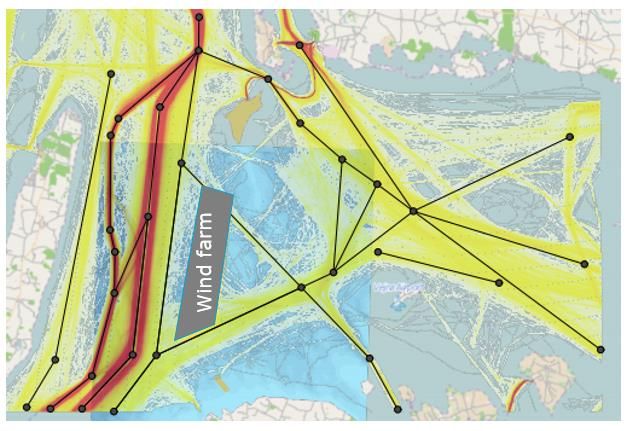
Contents

1         Project introduction and background ..................................................................................................................... 3
2         Scope........................................................................................................................................................................... 3
3         Approach and methods ............................................................................................................................................ 4
3.1       Task 1: Stakeholder analysis ......................................................................................................................................................4
3.2       Task 2: Maritime traffic study ...................................................................................................................................................5
3.2.1     Baseline area description ..........................................................................................................................................................5
3.2.2     Vessel traffic analysis ..................................................................................................................................................................5
3.2.3     Initial assessment on potential impact on traffic and routes ..........................................................................................6
3.3       Task 3: Hazard identification (HAZID) workshop ...............................................................................................................6
3.4       Task 4: Risk Assessment.............................................................................................................................................................8
3.4.1     IWRAP analysis tool ....................................................................................................................................................................9
3.4.2     Review of Export Cable Route ............................................................................................................................................... 10
3.4.3     Review of Potential Cumulative Impacts and Future Shipping .................................................................................... 10
3.5       Assumptions.................................................................................................................................................................................11

4         Deliverables ............................................................................................................................................................... 11

Project ID: 10412920
Document ID: RDJRNYFQ6AW5-451746203-816
Prepared by: Hans Jørgen Johnsrud, DNV Verified by: BHH Approved by: ALM
                                                                                                                                                                                                           2/12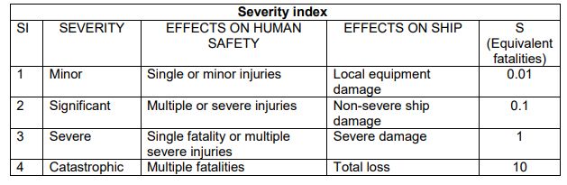
1 Project introduction and background
With the Climate Agreement for Energy and Industry of the 22nd of June 2020, the majority of the Danish Parliament
decided that Denmark will become the first country in the world to develop two energy. One of the islands will be
located in the North Sea (“Energioe Nordsoen”) with a capacity of 3 GW offshore wind surrounding the island. This
island can be further scaled up to allow for grid connection of up to 10 GW offshore wind on the island. It is expected
that Energioe Nordsoen will be in full operation by 2033.
The Danish Energy Agency (DEA) has initiated the Strategical Environmental Assessment (SEA) and associated
technical reports. This scope report includes a detailed description for the planned activities concerning maritime
traffic and safety of navigation (HAZID) (work package M).
This scope report includes a detailed description of the planned activities concerning the technical report regarding
maritime traffic and safety of navigation (HAZID) for Energoe Nordsoen.
2 Scope
The aim of this scoping report is to set the structural frame for the collection of and processing of data (scope of
work), which has to be used in the delivery of a technical background report defining the impact on marine traffic
from this project.
The technical background report for marine traffic defines the impact on marine traffic as a consequence of the
construction of the energy island and its associated offshore windfarms (OWF). In practice this will be done by
assessing the degree of impact as well as assess the risk of collision as a consequence of both the island and the
associated OWFs.
The tasks which will be completed in order to meet with the scope are listed below – and will all be described in
details in chapter 3:
Task Scope of work
Task 1: Stakeholder analysis Identify the relevant stakeholders to be consulted regarding hazard
identification
Task 2: Maritime traffic study Perform a baseline study of current maritime traffic within and around the
planned artificial island, offshore wind farms, belonging platform and
export cables.
Task 3: Hazard Identification Identify the relevant hazards through performing a HAZID (hazard
(HAZID) workshop identification) workshop with relevant stakeholders
Perform a HAZID analysis of ship and vessel traffic within and around the
project area in consequence of construction, operation and
decommissioning of the artificial island, offshore wind farms with
belonging platform and export cables
Identify measures to reduce risk of collisions, as required
Project ID: 10412920
Document ID: RDJRNYFQ6AW5-451746203-816
Prepared by: Hans Jørgen Johnsrud, DNV Verified by: BHH Approved by: ALM
3/12Task 4: Risk Assessment Assess impacts of the project on shipping and vessel traffic
Estimate risks of ship collisions with the artificial island and maritime OWF
structures (wind turbines and platform) during construction, operation and
decommissioning of the OWF.
The study will follow the guidelines of the International Maritime Organisation (IMO) for safety analysis (i.e. Formal
Safety Assessment - FSA method), together with possible specific requirements by the Danish Maritime Authority
(DMA, Søfartsstyrelsen).
3 Approach and methods
This chapter will specify the approach and methods being used to meet the scope (described in chapter 2). Task 1 and
2 (stakeholder analysis and maritime traffic study) are preparation for the HAZID-workshop (task 3). Based on inputs
from the HAZID-workshop, the risk assessment is conducted (task 4).
3.1 Task 1: Stakeholder analysis
The main scope for this task is to identify the relevant stakeholders to be consulted regarding hazard identification.
The following stakeholders will be considered (not limited to):
o Fishing industry
o Recreational craft users
o Commercial passenger vessels
o Tug operators
o Dry and wet cargo
o Marine pilots
o Port authorities
o Emergency responders
o Danish military
DNV will use its in-house BI tool for the stakeholder analysis, based on AIS-data. Figure 1.1 shows an example
dashboard from a fictive area. The values show the number of ships passing the given area per year. This data analysis
will be used to identify key stakeholders.
Project ID: 10412920
Document ID: RDJRNYFQ6AW5-451746203-816
Prepared by: Hans Jørgen Johnsrud, DNV Verified by: BHH Approved by: ALM
4/12Figure 3.1: DNV Microsoft Power BI tool for identifying relevant stakeholders.
3.2 Task 2: Maritime traffic study
The main scope of the maritime traffic study is to perform a baseline study of current maritime traffic within and
around the planned artificial island, offshore wind farms, belonging platform and export cables. The study will
encompass a:
o Baseline area description
o Vessel traffic analysis
o Initial assessment on potential impact on traffic and routes
3.2.1 Baseline area description
Data sets available for the baseline area description for the proposed development area and immediate surroundings
will be documented and analyzed for the Formal Safety Assessment (FSA).
The following data sources shall typically be reviewed and summarized:
o Nautical Charts (incl. Aids to Navigation)
o Sailing Directions (Pilot Books, DMA and IMO routing measures)
o Port and Harbours guidance
o Met Ocean data
o Search and Rescue (SAR) Facilities and Resources
o Historical Maritime Incidents (if available data)
3.2.2 Vessel traffic analysis
A suitable period including seasonal variations of AIS data and VMS data (fishery data) will be analyzed in detail to
understand the vessel traffic movements in the area. The high resolution AIS data will be gathered from the DMA
website “Danish AIS data”. This will include the following:
o Vessel movements and traffic patterns
o Vessel type and size
Project ID: 10412920
Document ID: RDJRNYFQ6AW5-451746203-816
Prepared by: Hans Jørgen Johnsrud, DNV Verified by: BHH Approved by: ALM
5/12o Vessel speed (knots) per route per ship type
o Vessel densities/heat maps
o Main routes, traffic lanes by vessel type
As the planned energy island and the pre-investigation area is outside Danish territorial waters, and thus far from the
coast, there may be challenges in obtaining AIS data. At that distance from the coast, one is dependent on AIS data
points from satellites, as opposed to closer to the coast where land-based AIS receiving stations can be used.
Data adequacy will be evaluated initially, including the quality of public source AIS data. When AIS data is imported,
the coverage is analyzed looking at the distribution of AIS messages over time. If the data quality is poor or missing, it
will be reported and analyzed, and a solution with Energinet will be agreed. In addition, DNV also has AIS in-house
data that can be used in the project.
3.2.3 Initial assessment on potential impact on traffic and routes
DNV will perform an initial assessment of the potential impacts the planned artificial island and OWF’s may have on
the existing traffic pattern by evaluating which traffic/routes that need to adjust (e.g. move or merge into other nearby
routes).
All analyses in Task 2 (Maritime Traffic Study) will be summarized in a Power Point presentation, with figures, tables
and associated commentary text as appropriate. The presentation will be distributed to all participants prior to the
HAZID workshop for their preparations and thereby increasing the efficiency of the workshop.
3.3 Task 3: Hazard identification (HAZID) workshop
A 1-day hazard identification workshop will be conducted. The main objective of the workshop is the systematic
identification of any hazards/aspects, which may have the potential to cause harm, followed by a review to determine
whether adequate safeguards exist, or additional safeguards are required to mitigate the potential consequences. A
qualitative evaluation of risk will also be included, by using a risk matrix.
The guidelines of the International Maritime Organisation (IMO) for safety analysis (FSA) shall be applied in the HAZID
analysis, together with any specific requirements made by the Danish Maritime Authority (DMA, Søfartsstyrelsen).
In the HAZID it is also important to capture any future traffic and/or route developments, which is not possible to
identify by only looking at historic AIS-data. Therefore, it is essential to involve relevant stakeholders operating in the
area (ferry operators, ports, etc.) in the HAZID, as well as maritime authorities in Denmark and neighboring countries
(at least, but not limited to Norway, UK and Germany).
The HAZID starts the safety management process and provides a traceable record of the hazards identified and the
actions taken. The study therefore provides input to subsequent quantitative risk assessment study.
The HAZID will be based on the SWIFT (Structured What-If Technique) and will involve a series of keywords/guide-
words for the systematic identification of potential hazards and major incidents. DNV GL will use a combination of
guidewords from industry guidelines (e.g. ISO 17776) and our experience to generate the guideword list.
The detailed methodology to be applied in the HAZID workshop follows the steps outlined below (and illustrated in
Figure 1.2):
Project ID: 10412920
Document ID: RDJRNYFQ6AW5-451746203-816
Prepared by: Hans Jørgen Johnsrud, DNV Verified by: BHH Approved by: ALM
6/12o Identification of HAZID nodes (ship routes)
o Node briefing (traffic composition)
o Identification of hazards, their causes and consequences
o Identification of preventive and mitigating measures
o Determination of severity, likelihood and risk
o Identification of action Items
Take first/next hazard
Identify causes of hazard being realized
Identify consequences
Identify safeguards in place or planned
(Risk rank the identified consequences)
Yes
Are safeguards sufficient?
No
Agree recommendations
Yes More consequences to consider?
No
More causes to consider?
Yes
No
Yes More hazards to consider?
No
Next section/finish
Figure 3.2: HAZID process.
Since the hazards identified in the HAZID workshop shall be quantified in the Risk Assessment (i.e. frequency analysis),
risk ranking done by the workshop participants are not really needed. However, a qualitative/semi-quantitative risk
evaluation using a risk matrix will be performed to highlight the specific hazards and areas where the Risk Assessment
should have particular focus. The risk ranking may also cover hazards that may (due to limited amount of data) be
difficult to quantify.
Project ID: 10412920
Document ID: RDJRNYFQ6AW5-451746203-816
Prepared by: Hans Jørgen Johnsrud, DNV Verified by: BHH Approved by: ALM
7/12A risk matrix with probability and consequence classes, based on FSA methodology will be used in this study; see
Figure 1.3, Figure 1.4 and Figure 1.5. The risk matrices (Figure 1.3, 1.4 and 1.5) may be changed pending on client’s
request and/or to be aligned between the two projects (Energy Island North Sea and Energy Island Baltic Sea).
Figure 3.3: Consequence classes.
Figure 3.4: Probability classes
Figure 3.5: Risk index.
The HAZID Workshop will be conducted as an online event in week 3 2022. To secure the most sufficient workshop,
the following principles will be used:
o Max 2 persons from same company/organization.
o Invitations of “umbrella organizations” instead of single entities, to the extent possible.
o Only stakeholders with relevance and/or interest in maritime safety and navigation for the specific location is
invited.
3.4 Task 4: Risk Assessment
A Formal Safety Assessment (FSA) will be carried out in line with IMO guidelines. A key component will be inputs from
the HAZID-workshop involving key project personnel as well shipping and navigational stakeholders, both statutory
and local. During the HAZID-workshop shipping and navigation hazards are identified and ranked, and potential risk
control/mitigation measures are identified and can be assessed further within the FSA process.
Project ID: 10412920
Document ID: RDJRNYFQ6AW5-451746203-816
Prepared by: Hans Jørgen Johnsrud, DNV Verified by: BHH Approved by: ALM
8/12The impacts to be assessed will include:
o Ship to wind turbine/platform collision risks (modelling of the baseline layout + one additional/alternative layout)
o Ship to energy island collision (modelling of the baseline layout + one additional/alternative layout)
o Ship to ship collision risk (change in risk) before and after energy island and wind farm development
o Navigational impact in terms of re-routing of traffic
o Additional impacts of installation vessels (and any associated safety zones)
o Additional impacts of maintenance vessels
o Impact on SAR resources
Note that decommissioning impacts are expected to be similar to those identified during installation.
The objective is to quantify to what extent the ship traffic in the area will be influenced by the artificial island and the
wind farms and to calculate any associated increase in the navigational risk in the region near the project area.
The risk assessment will be performed by conducting a quantitative frequency analysis, calculating the expected
frequency (and return period) of collisions with the OWF’s and the other navigational risk (i.e. potential increase in
ship-ship collisions due to traffic being merged).
DNV will use the IALA Waterway Risk assessment Programme (IWRAP tool) for the AIS vessel traffic analysis and
collision/allision risk assessment. These same tool and models have been used in numerous similar assessments of
other Danish and European offshore wind farms, and are fully accepted by the relevant National Authorities in each
case.
The following describes the method for performing the frequency analysis. The frequency analysis is based on
acknowledged mathematical models typically used for such analyses and with input based on historical (statistical)
data. The applied calculation tool IWRAP MKII is a part of the IALA Recommendation [IALA O-134] on risk
management.
3.4.1 IWRAP analysis tool
The IWRAP MKII software (hereinafter referred to as IWRAP) calculates the probability of collision or grounding for a
vessel operating on a specified route. The applied model for calculating the frequency of grounding or collision
accident involves the use of a so-called causation probability that is multiplied onto a theoretically obtained number
of grounding or collision candidates. The causation factor models the probability of the officer on the watch not
reacting in time given that he is on collision course with another vessel (or – alternatively – on grounding course).
A description of the ship traffic constitutes the central input for a navigational risk assessment. AIS data provides a
detailed geographic and temporal description of the ship traffic in a region and has been used as the primary data
basis. Because the predominant part of the ship traffic is following navigational routes – which can be more or less
well defined – the modelling of the ship traffic and the associated models of the risk of collisions and groundings
usually adopts a route-based description of the traffic.
The ship traffic description based on AIS is thus subsequently used as basis for definition of the routes in the
probabilistic model in IWRAP.
Project ID: 10412920
Document ID: RDJRNYFQ6AW5-451746203-816
Prepared by: Hans Jørgen Johnsrud, DNV Verified by: BHH Approved by: ALM
9/12Figure 3.6: Example of IWRAP model set-up with routes and location of wind farm (in grey).
IWRAP is a preferred tool for this risk assessment because of the following reasons:
o Utilizes high resolution AIS data.
o Easy/flexible to change routes, e.g. make a new route system.
o Industry recognized software and recommended by IALA
o ‘All-in-one software’ from AIS data input to output detailed risk calculations.
DNV has extensive experience in using IWRAP for governmental authorities and companies. There exists an IWRAP
manual, but in-depth understanding of the software capabilities and weaknesses are really needed to avoid going into
pitfalls when doing the modelling. DNV GL developed a customised IWRAP-guidance manual for the Norwegian
Coastal Authority (NCA) for use in navigational risk assessments.
DNV also have the necessary international ship databases to extract ship information for the AIS messages.
3.4.2 Review of Export Cable Route
A high level (qualitative) review of potential cable impacts from anchoring and fishing will be carried out using the
available baseline data covering the proposed cable route(s), e.g., AIS and VMS. The review will identify areas of
existing anchoring and fishing practises along the proposed cable route(s) that could lead to potential interaction with
the cable, as well as areas of high traffic density such as TSSs where emergency anchoring and/or vessel access for
cable laying / maintenance could pose an issue.
3.4.3 Review of Potential Cumulative Impacts and Future Shipping
The previous tasks will have considered the proposed project in isolation. Under this task the potential cumulative and
in-combination impacts on shipping (of any nearby developments in the area) will be reviewed. This will include any
proposed developments not yet constructed, but scoped, within the area.
Project ID: 10412920
Document ID: RDJRNYFQ6AW5-451746203-816
Prepared by: Hans Jørgen Johnsrud, DNV Verified by: BHH Approved by: ALM
10/123.5 Assumptions
The most important assumption in this work package will be the layout of the OWF and the artificial island. The
layouts will influence the navigational safety. It is assumed that Energinet will provide a set of project assumptions
regarding the energy island and the wind farm layout (number and heights of wind turbines etc.) that may be used as
background for the assessments to be made under this work package.
It is important that the layout and design of the artificial island and the OFW used in this work package is identical to
the layout used for other work packages to ensure consistency of the assessments.
This proposal includes the risk modelling of the baseline/proposed layout.
Other assumptions will be handled during the actual work. All assumptions used as basis for the risk assessment will
be informed and may be reviewed by Energinet.
It is assumed that AIS data can be imported from DMA’s website, as has been the case for other Danish Offshore
Windfarm projects. Thus, cost of AIS data is not included, only processing/downloading.
The interconnector cable is not included in the planned work.
4 Deliverables
Deliverables from this work package are summarized below:
Task Deliverables
Task 1: Stakeholder Internal project deliverable to Energinet: Invitation list to the HAZID workshop
analysis (incl. names, company, contact info etc.) and invitation.
Task 2: Maritime traffic Power Point presentation, which will be distributed to all participants prior to
study the HAZID workshop, summarising: Baseline area description, vessel traffic
analysis and initial assessment on potential impact on traffic and routes.
Task 3: Hazard HAZID report with the log sheet, participants, method, etc., summarising all
Identification (HAZID) findings in the workshop.
workshop
Task 4: Risk Assessment Risk Assessment report (also referred to as ‘technical report’ and ‘Safety of
navigation report’. This is the final and main report from this work package,
and it will also include the content from the technical memo and the HAZID
report.
Moreover, some details on the HAZID report and the Risk Assessment Report are provided below.
The HAZID report will be generated following the workshop, which will include the following:
Project ID: 10412920
Document ID: RDJRNYFQ6AW5-451746203-816
Prepared by: Hans Jørgen Johnsrud, DNV Verified by: BHH Approved by: ALM
11/12o List of stakeholders
o List of attendees
o Workshop methodology
o Background documents/presentation
o Table of Hazards identified for construction, operation and decommissioning
o Qualitative risk evaluation (risk matrix)
o Possible risk reducing measures (as proposed during the HAZID)
The Risk Assessment Report will include:
o Method description
o Current maritime traffic and shipping/ferry lanes
o Identified hazards during construction, operation and decommission of the OWF with platform and export cables,
and also the artificial island
o Assessment of risks of collisions
o Proposals for risk-reducing measures with inputs from the DMA (Søfartsstyrelsen)
o Identification of possible data gaps and insufficiencies of importance for the risk assessment
Appendices on collected data on maritime traffic and on the detailed risk calculations performed.
Data presented in the appendices to the technical report will also be submitted in an Excel compatible format where
applicable and/or required. This relates specifically to:
o Data on maritime traffic etc. from AIS (Automatic Information System)
o Detailed risk calculations
The time schedule for the work package activities is:
o Week 40 2021: 1st draft scope report
o Week 48 2021: Final version scope report
o Week 3 2022: HAZID workshop
o Week 4 – week 13 2022: Data collection and data processing completed
o Week 22 2022: First draft version
o Week 35 2022: Final draft version
o Week 40 2022: Final report
Project ID: 10412920
Document ID: RDJRNYFQ6AW5-451746203-816
Prepared by: Hans Jørgen Johnsrud, DNV Verified by: BHH Approved by: ALM
12/12You can also read