Appendix 4: Forage Crop Frequency Data for the years 2011 2020 - NET
←
→
Page content transcription
If your browser does not render page correctly, please read the page content below

Appendix 4: Forage Crop Frequency Data for the
            years 2011 – 2020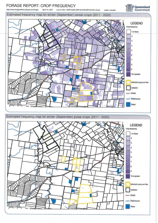
FORAGE REPORT: CROP FREQUENCY
http://www.longpaddock.qld.gov.au/forage March 31, 2021 Lot on Plan: 27SP253612 Label: noLabel
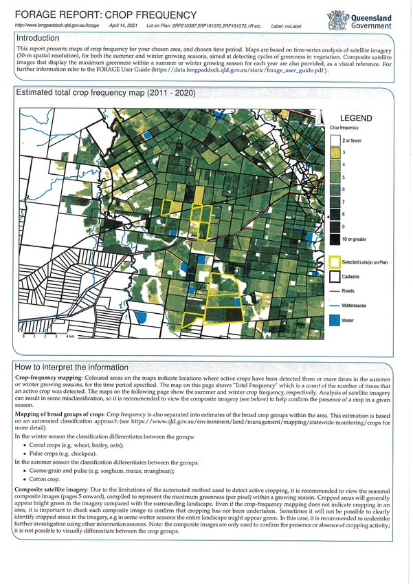
Introduction
This report presents maps of crop frequency for your chosen area, and chosen time period. Maps are based on time-series analysis of satellite imagery
(30-m spatial resolution), for both the summer and winter growing seasons, aimed at detecting cycles of greenness in vegetation. Composite satellite
images that display the maximum greenness within a summer or winter growing season for each year are also provided, as a visual reference. For
further information refer to the FORAGE User Guide (https://data.longpaddock.qld.gov.au/static/forage_user_guide.pdf ) .
Estimated total crop frequency map (2011 - 2020)
How to interpret the information
Crop-frequency mapping: Coloured areas on the maps indicate locations where active crops have been detected three or more times in the summer
or winter growing seasons, for the time period specified. The map on this page shows "Total Frequency" which is a count of the number of times that
an active crop was detected. The maps on the following page show the summer and winter crop frequency, respectively. Analysis of satellite imagery
can result in some misclassification, so it is recommended to view the composite imagery (see below) to help confirm the presence of a crop in a given
season.
Mapping of broad groups of crops: Crop frequency is also separated into estimates of the broad crop groups within the area. This estimation is based
on an automated classification approach (see https://www.qld.gov.au/environment/land/management/mapping/statewide-monitoring/crops for
more detail).
In the winter season the classification differentiates between the groups:
• Cereal crops (e.g. wheat, barley, oats);
• Pulse crops (e.g. chickpea).
In the summer season the classification differentiates between the groups:
• Coarse-grain and pulse (e.g. sorghum, maize, mungbean);
• Cotton crop.
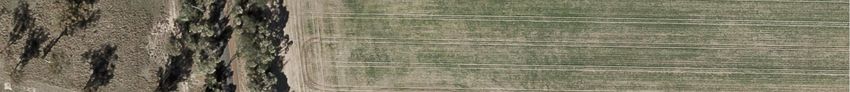
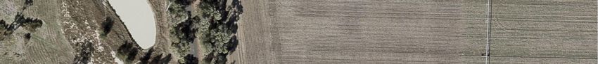
Composite satellite imagery: Due to the limitations of the automated method used to detect active cropping, it is recommended to view the seasonal
composite images (pages 5 onward), compiled to represent the maximum greenness (per pixel) within a growing season. Cropped areas will generally
appear bright green in the imagery compared with the surrounding landscape. Even if the crop-frequency mapping does not indicate cropping in an
area, it is important to check each composite image to confirm that cropping has not been undertaken. Sometimes it will not be possible to clearly
identify cropped areas in the imagery, e.g in some wetter seasons the entire landscape might appear green. In this case, it is recommended to undertake
further investigation using other information sources. Note: the composite images are only used to confirm the presence or absence of cropping activity;
it is not possible to visually differentiate between the crop groups.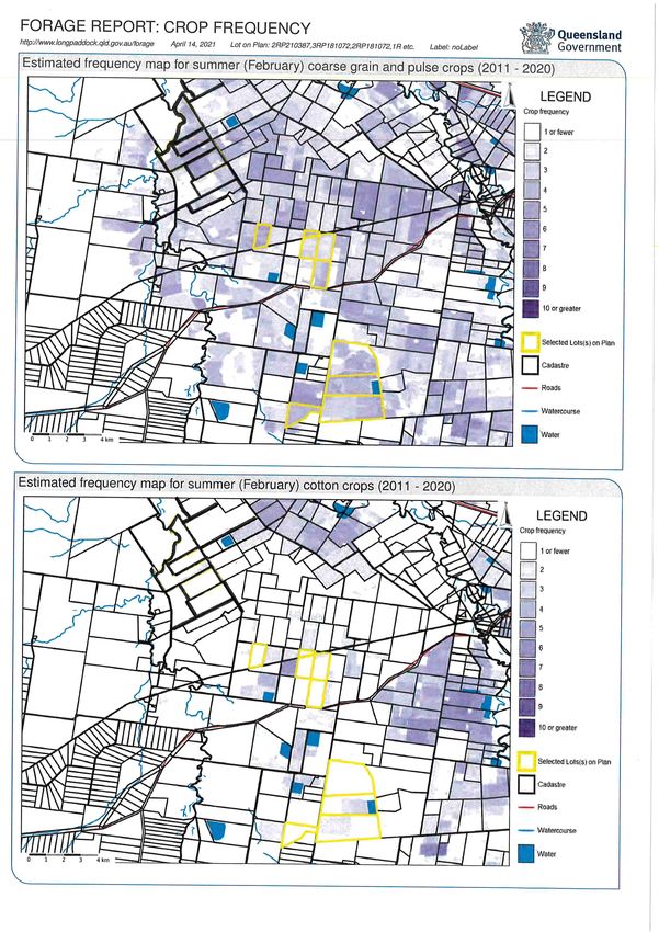
FORAGE REPORT: CROP FREQUENCY
http://www.longpaddock.qld.gov.au/forage   March 31, 2021   Lot on Plan: 27SP253612   Label: noLabel

Estimated frequency map for summer (February) crops (2011 - 2020)

Estimated frequency map for winter (September) crops (2011 - 2020)
FORAGE REPORT: CROP FREQUENCY
http://www.longpaddock.qld.gov.au/forage   March 31, 2021   Lot on Plan: 27SP253612   Label: noLabel

Estimated frequency map for summer (February) coarse grain and pulse crops (2011 - 2020)

Estimated frequency map for summer (February) cotton crops (2011 - 2020)
FORAGE REPORT: CROP FREQUENCY
http://www.longpaddock.qld.gov.au/forage   March 31, 2021   Lot on Plan: 27SP253612   Label: noLabel

Estimated frequency map for winter (September) cereal crops (2011 - 2020)

Estimated frequency map for winter (September) pulse crops (2011 - 2020)

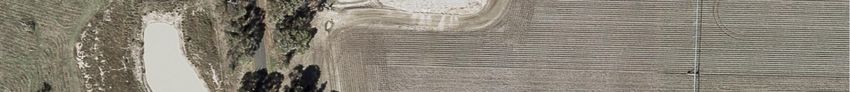
FORAGE REPORT: CROP FREQUENCY
http://www.longpaddock.qld.gov.au/forage   March 31, 2021   Lot on Plan: 27SP253612   Label: noLabel

February (left) and September (right) images for 2011

February (left) and September (right) images for 2012

February (left) and September (right) images for 2013
FORAGE REPORT: CROP FREQUENCY
http://www.longpaddock.qld.gov.au/forage   March 31, 2021   Lot on Plan: 27SP253612   Label: noLabel

February (left) and September (right) images for 2014

February (left) and September (right) images for 2015

February (left) and September (right) images for 2016
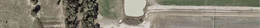
FORAGE REPORT: CROP FREQUENCY
http://www.longpaddock.qld.gov.au/forage   March 31, 2021   Lot on Plan: 27SP253612   Label: noLabel

February (left) and September (right) images for 2017

February (left) and September (right) images for 2018

February (left) and September (right) images for 2019
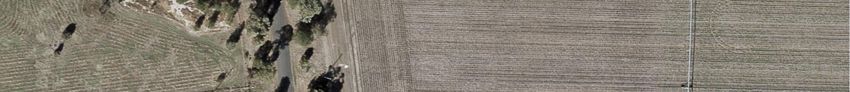
FORAGE REPORT: CROP FREQUENCY
http://www.longpaddock.qld.gov.au/forage   March 31, 2021   Lot on Plan: 27SP253612   Label: noLabel

February (left) and September (right) images for 2020

Disclaimer
 Limitation of liability: the State of Queensland, as represented by the Department of Environment and Science (DES) gives no warranty in relation
 to the data (including without limitation, accuracy, reliability, completeness or fitness for a particular purpose). To the maximum extent permitted by
 applicable law, in no event shall DES be liable for any special, incidental, indirect, or consequential damages whatsoever (including, but not limited to,
 damages for loss of profits or confidential or other information, for business interruption, for personal injury, for loss of privacy, for failure to meet any
 duty including of good faith or of reasonable care, for negligence, and for any other pecuniary or other loss whatsoever including, without limitation,
 legal costs on a solicitor own client basis) arising out of, or in any way related to, the use of or inability to use the data. c The State of Queensland, 2021.
FORAGE REPORT: CROP FREQUENCY
http://www.longpaddock.qld.gov.au/forage   April 7, 2021   Lot on Plan: 2DER3455   Label: noLabel

Introduction
 This report presents maps of crop frequency for your chosen area, and chosen time period. Maps are based on time-series analysis of satellite imagery
 (30-m spatial resolution), for both the summer and winter growing seasons, aimed at detecting cycles of greenness in vegetation. Composite satellite
 images that display the maximum greenness within a summer or winter growing season for each year are also provided, as a visual reference. For
 further information refer to the FORAGE User Guide (https://data.longpaddock.qld.gov.au/static/forage_user_guide.pdf ) .

Estimated total crop frequency map (2011 - 2020)

How to interpret the information
 Crop-frequency mapping: Coloured areas on the maps indicate locations where active crops have been detected three or more times in the summer
 or winter growing seasons, for the time period specified. The map on this page shows "Total Frequency" which is a count of the number of times that
 an active crop was detected. The maps on the following page show the summer and winter crop frequency, respectively. Analysis of satellite imagery
 can result in some misclassification, so it is recommended to view the composite imagery (see below) to help confirm the presence of a crop in a given
 season.
 Mapping of broad groups of crops: Crop frequency is also separated into estimates of the broad crop groups within the area. This estimation is based
 on an automated classification approach (see https://www.qld.gov.au/environment/land/management/mapping/statewide-monitoring/crops for
 more detail).
 In the winter season the classification differentiates between the groups:
     • Cereal crops (e.g. wheat, barley, oats);
     • Pulse crops (e.g. chickpea).
 In the summer season the classification differentiates between the groups:
     • Coarse-grain and pulse (e.g. sorghum, maize, mungbean);
     • Cotton crop.
 Composite satellite imagery: Due to the limitations of the automated method used to detect active cropping, it is recommended to view the seasonal
 composite images (pages 5 onward), compiled to represent the maximum greenness (per pixel) within a growing season. Cropped areas will generally
 appear bright green in the imagery compared with the surrounding landscape. Even if the crop-frequency mapping does not indicate cropping in an
 area, it is important to check each composite image to confirm that cropping has not been undertaken. Sometimes it will not be possible to clearly
 identify cropped areas in the imagery, e.g in some wetter seasons the entire landscape might appear green. In this case, it is recommended to undertake
 further investigation using other information sources. Note: the composite images are only used to confirm the presence or absence of cropping activity;
 it is not possible to visually differentiate between the crop groups.
FORAGE REPORT: CROP FREQUENCY http://www.longpaddock.qld.gov.au/forage April 7, 2021 Lot on Plan: 2DER3455 Label: noLabel Estimated frequency map for summer (February) crops (2011 - 2020) Estimated frequency map for winter (September) crops (2011 - 2020)
FORAGE REPORT: CROP FREQUENCY
http://www.longpaddock.qld.gov.au/forage   April 7, 2021   Lot on Plan: 2DER3455   Label: noLabel

Estimated frequency map for summer (February) coarse grain and pulse crops (2011 - 2020)

Estimated frequency map for summer (February) cotton crops (2011 - 2020)
FORAGE REPORT: CROP FREQUENCY
http://www.longpaddock.qld.gov.au/forage   April 7, 2021   Lot on Plan: 2DER3455   Label: noLabel

Estimated frequency map for winter (September) cereal crops (2011 - 2020)

Estimated frequency map for winter (September) pulse crops (2011 - 2020)
FORAGE REPORT: CROP FREQUENCY
http://www.longpaddock.qld.gov.au/forage   April 7, 2021   Lot on Plan: 2DER3455   Label: noLabel

February (left) and September (right) images for 2011

February (left) and September (right) images for 2012

February (left) and September (right) images for 2013
FORAGE REPORT: CROP FREQUENCY
http://www.longpaddock.qld.gov.au/forage   April 7, 2021   Lot on Plan: 2DER3455   Label: noLabel

February (left) and September (right) images for 2014

February (left) and September (right) images for 2015

February (left) and September (right) images for 2016
FORAGE REPORT: CROP FREQUENCY
http://www.longpaddock.qld.gov.au/forage   April 7, 2021   Lot on Plan: 2DER3455   Label: noLabel

February (left) and September (right) images for 2017

February (left) and September (right) images for 2018

February (left) and September (right) images for 2019
FORAGE REPORT: CROP FREQUENCY
http://www.longpaddock.qld.gov.au/forage   April 7, 2021   Lot on Plan: 2DER3455   Label: noLabel

February (left) and September (right) images for 2020

Disclaimer
 Limitation of liability: the State of Queensland, as represented by the Department of Environment and Science (DES) gives no warranty in relation
 to the data (including without limitation, accuracy, reliability, completeness or fitness for a particular purpose). To the maximum extent permitted by
 applicable law, in no event shall DES be liable for any special, incidental, indirect, or consequential damages whatsoever (including, but not limited to,
 damages for loss of profits or confidential or other information, for business interruption, for personal injury, for loss of privacy, for failure to meet any
 duty including of good faith or of reasonable care, for negligence, and for any other pecuniary or other loss whatsoever including, without limitation,
 legal costs on a solicitor own client basis) arising out of, or in any way related to, the use of or inability to use the data. c The State of Queensland, 2021.
AECOM                                                 Résumé      Navjot Kaur                                                                 2
                                                                  Technical Lead - Acid Sulfate Soils, Principal Soil Scientist

Detailed Experience                                                            -     Data management software (gINT,
Navjot’s range of experience includes conducting                                     ESDAT, EQUIS) and MS office for
environmental management works on oil & gas,                                         graphs, logs, statistics and report
mining, commercial and industrial sites                                              preparation
undertaking the following:
                                                                        ·      Project Management:
·     Environmental Impact Assessment
                                                                               -     scope development, cost estimation,
      -      Soil and Land Classification based on                                   project administration, budget
             Australian Soil Classification System                                   management, cost control and project
                                                                                     completion
      -      Land Suitability, Strategic Cropping
             Land (SCL) and Topsoil assessment                                 -     Contractor administration, bid/tender
                                                                                     evaluation, procurement and invoicing
      -      Identification and management of Acid
             Sulfate Soils (ASS)                                               -     Supervision of junior staff and
                                                                                     contractors
      -      Site reinstatement and rehabilitation
                                                                        Key Projects at AECOM:
·     Environmental Sites Assessment and
      Remediation:                                                      ·      Acid Sulfate Soils intrusive investigation and
                                                                               development of ASSMP for Cross River Rail
      -      Environment and Human health risk
                                                                               – Rail Integration System (RIS) – Lead Acid
             assessment and mitigation
                                                                               Sulfate Soils Specialist - Co-ordination of
      -      Soil, soil gas, surface water and                                 fieldwork, data analysis, interpretation and
             groundwater investigations                                        Reporting
      -      Remediation of hydrocarbon, metals,                        ·      Frac Ponds Decommissioning and
             salts and solvent impacted sites                                  Rehabilitation, QGC, Technical Lead and
                                                                               Project Manager. Co-ordination of fieldwork,
·     Environmental Compliance:                                                data analysis, interpretation and Reporting
      -      Environmental Management Plans
                                                                        ·      Acid Sulfate Soil assessment for road
             (EMP) development and implementation
                                                                               upgrade works at Walkerston Bypass,
      -      Environmental audits (internal and 3rd                            Mackay, Project – Desktop assessment, data
             party) and approvals/ license documents                           analysis and reporting as per Qld Guidelines
      -      Incident response, monitoring, sampling, ·                        Contaminated land and Acid Sulfate Soil
             mitigation, and reporting                                         assessment for underground rail tunnel in
                                                                               Brisbane – Desktop assessment
·     Water Management:
                                                                        ·      Acid Sulfate Soil assessment for road
      -      Dewatering programs and groundwater
                                                                               upgrade works at Port Alma Road, Bajool,
             treatment systems
                                                                               Project – Desktop assessment, data analysis
      -      Bore drilling and well installation;                              and reporting as per Qld Guidelines
             compliance monitoring and sampling
                                                                        ·      Stage 1 and Stage 2 Contamination
·     Waste Management:                                                        Investigation across the whole RAAF Base
                                                                               Amberley – Desktop, fieldwork, data analysis
      -      Contaminated/ hazardous and non-
                                                                               and reporting
             hazardous waste management and
             transport                                                  ·      Stage 1 and Stage 2 Contamination
                                                                               Investigation across the whole Gallipoli
      -      Drilling waste management including
                                                                               Barracks Enoggera – Desktop, fieldwork,
             drilling muds disposal
                                                                               data analysis and reporting
·     Health, Safety & Environment:
                                                                        ·      Stage 2 Contamination Investigation across
      -      Development and implementation of                                 the whole Jennings Defence Base –
             project specific health and safety plans                          Desktop, fieldwork, data analysis and
                                                                               reporting
      -      Conduct inductions, risk assessments,
             incident investigation, auditing                           ·      Soil Assessment for PFAS and other
                                                                               Contaminants for Growler Project, RAAF
·     Data management, Interpretation and Report
      Writing

26-Aug-2019
l:\secure\projects\606x\60647277\500_deliverables\501_deliverable_rdm post-application soil sampling\app e - cvs\cv_navjot kaur_master.docx
AECOM Résumé Navjot Kaur 3
Technical Lead - Acid Sulfate Soils, Principal Soil Scientist
Amberley - Desktop assessment, data · LendLease – RNA Showgrounds
analysis and reporting Development Project – Contaminated land
and ASS investigation and management –
· Coastal Acid Sulfate Soil assessment
Team member
(CASS) for North East Link (NELA) Project –
Desktop assessment, data analysis and · Part of the Team for Origin Energy CSG
reporting as per Victorian Guidelines Dams Remediation Project SELECT Phase
· Land Capability Assessment for onsite · Defence – RAAF Base Amberley, Phase 1
Effluent Disposal at a site in Melbourne. It and site contamination Investigation, C17,
included assessment of topsoil and subsoil Growler, Battlefield airlifter etc. – fieldwork
and water balance calculations. and reporting
· Coastal Acid Sulfate Soil assessment · Caltex Gold Coast Airport, JUHI and PRA
(CASS) for Melbourne Metro Project – Remediation including ASS management
Desktop assessment, data analysis and
reporting as per Victorian Guidelines · UPSS Inspections at various sites for
Goodman Pty Ltd – Project Team, fieldwork
· Stage C Groundwater Assessment – AACO and reporting
Base, Oakey – Reporting
· Deputy Project manager (DPM) for BP
· Groundwater Radioactive Assessment - contaminated land investigation at Charters
Defence Science and Technology Group, Towers.
Fishermans’ bend – Fieldwork and reporting
· Caltex Sites Groundwater Investigation at
· Exxon Mobil Altona Refinery Sediment North Queensland - DPM
Assessment - project management and
reporting · Origin Energy former gasworks sites
Bundaberg, QLD Project Team, fieldwork
· Coastal Acid Sulfate Soil assessment and reporting.
(CASS) for Edithvale and Bonbeach Level
Crossing Removal (LXRA) Projects - · Origin Energy former gasworks sites,
Desktop assessment, data analysis and Maryborough, QLD Project Team, fieldwork
reporting as per Victorian Guidelines and reporting.
· Project manager, Soil sampling at Oakey · Remediation Plans for Origin Energy former
Base for PFC assessment in Soils for gasworks sites at Warwick and Bundaberg,
disposal QLD Team lead.
· Project manager, Soil sampling at Oakey · Part of the Team for Origin Energy CSG
Civil Terminal for PFC assessment in Soils Dams Remediation Project Phase 2.
for disposal · Origin Energy Asbestos Investigation Project
· Santos Remediation Project at Roma – – Project Team, fieldwork and reporting.
Project team, fieldwork and reporting · Caltex UPSS 2014, reporting for select sites.
· Oakey Groundwater Investigation, AACO · Phase I Environmental Investigation at
base Oakey – Project team, fieldwork and different sites for Goodyear Pty Ltd – Project
reporting Team, fieldwork and reporting
· Growler Project, RAAF Base Amberley · Soils and topography as part of the EIS for a
Additional Soil Characterization including major underground combined Bus and Train
assessing soils for PFC contamination (BAT) tunnel project in Brisbane – Team
· C-17 Project RAAF Base Amberley lead.
Additional Soil Characterization including Historical Projects:
assessing soils for PFC contamination
· Groundwater monitoring sampling and report
· Contamination Investigation for Acid storage writing for key Shell retail and distribution
dam, Incitec Pivot, Phosphate Hill sites in and across Brisbane – Project team
· Origin Energy, Deep Drilling for groundwater · Groundwater investigation including
monitoring wells at Ironbark. halogenated compounds for an Industrial site
26-Aug-2019
l:\secure\projects\606x\60647277\500_deliverables\501_deliverable_rdm post-application soil sampling\app e - cvs\cv_navjot kaur_master.docxAECOM Résumé Navjot Kaur 4
Technical Lead - Acid Sulfate Soils, Principal Soil Scientist
(BOC), fieldwork and report preparation – · How to Write Effective Reports, one day
Project team training at Australian Institute of
Management (AIM)
· Environmental Site assessment (Phase I
and Phase II) – Project Manager/Site · 40 Hour Health and Safety Training
Supervisor. (HAZWOPER)
· Posted on secondment for an year with a · 30215 QLD Construction Industry Safety
major CSG project (Santos), Data manager Induction (Blue Card)
for Quality control and assurance of
environmental data · PMASUP236A Operate Vehicle in the Field
4WD,
· CSG Pipeline Construction (Origin Energy
via East Coast Pipeline) – Project Manager, · Santos Environment Health and Safety
SCL and Topsoil Assessment. Induction Rev 7.3 including gas Certificate
· Disposal Options for Drilling Muds for CSG · Senior First Aid and CPR training
industry (Origin energy) – Project Team, · Australian Institute of Petroleum Permit
Desktop review, field trials. System
· CSG Gas fields EIS – Project Team, Soil · MOBIL Loss Prevention System Training
survey and land assessment.
· Shell Coles Express Online Induction A and
· Major underground tunnel project – Team B
lead, ASS investigation and management.
· Shell Approved Retail and Distribution Permit
· Site closure for Box cut mine – Team Lead, Holder Training
Dewatering, Soil treatment and re-interment.
· Working in Electrified Territory (WET), Safely
· Soils and groundwater remediation including Accessing the Rail Corridor (SARC), Fatigue
ASS soils management at a major fuel Management, Category 3 Medical
distribution centre (ExxonMobil) – Project
Team · Rail Industry Worker (RIW) card
· ASS soils investigation for various projects at Other Languages
Brisbane Airport including fieldwork – Project Punjabi, Hindi
team Professional History
· Marine sediment sampling program 2020 - Present
associated with the proposed LNG (Liquefied AECOM
Natural Gas) plant in the Port of Gladstone Principal Soil Scientist – Technical Lead Acid
(Santos) Sulfate Soils
· Marine Sediment analysis involving a 2016 - 2020
proposed dredge area for the removal of the AECOM
subsea section of a decommissioned Senior Soil Scientist - RCE
pipeline bundle (Caltex Refineries Pty Ltd)
2014 - 2016
Conferences AECOM
Soil Science Conference, Canberra, 2018 Professional Environmental Scientist - RCE
Mine Closure, Brisbane 2012 2008 - 2013
Training URS Australia Pvt Ltd
Soil Scientist
· AECOM Certified Project Manager
2005 - 2008
· Acid Sulfate Soils; Identification, Assessment
Simmonds and Bristow Pvt Ltd
and Management, Three day short Course
Scientist
· Nature and Distribution of Queensland Soils
2003 - 2004
as per Australian System of Classification, Sydney Environmental & Soil Laboratory Pvt Ltd
Two Day Training Analyst
· Software Training gINT, Three day training
· Software Training ESDAT, one day training
26-Aug-2019
l:\secure\projects\606x\60647277\500_deliverables\501_deliverable_rdm post-application soil sampling\app e - cvs\cv_navjot kaur_master.docxAppendix 8: EWAs associated with the LPH on
subject lots151°5'45"E 151°5'48"E 151°5'51"E 151°5'54"E 151°5'57"E
27°19'24"S
27°19'24"S
2RP210387
SHARRON LOUISE HENRY; CLIFFORD LESTER WEIER
27°19'27"S
27°19'27"S
241 m2
2273 m2
27°19'30"S
27°19'30"S
PL260
3RP181072
SUZANNE MAREE & NOEL VICTOR ROCKLIFF
27°19'33"S
27°19'33"S
10RP811991
JULIE ANNE & GRAHAM LINDSAY BRYANT
27°19'36"S
27°19'36"S
Legend
LPH Pipe Datum Line
Existing Access Track
Proposed Access Track
Extra Work Area
Subject Property
PL (Arrow)
27°19'39"S
Ü
151°5'45"E 151°5'48"E 151°5'51"E 151°5'54"E 151°5'57"E
Scale @ A3: 1:1,500 Coordinate System: GDA 1994 MGA Zone 56
Metres
Confidential: For Internal Use Only
0 15 30 60 90 120
Based on or contains data provided by the State of Queensland.
In consideration of the State permitting use of this data
Disclaimer: While all reasonable care has been taken to ensure the information
contained on this map is up to date and accurate, no w arranty is given that the Status: IFI
DK West - LPH
you acknow ledge and agree that the State gives no warranty in relation to the data (including
accuracy, reliability, completeness, currency or suitability) and accepts no liability (including
information contained on this map is free from error or omission. Any reliance
placed on such information shall be at the sole risk of the user. Please verify the
Issued To:A Hall
without limitation, liability in negligence) for any loss, damage or costs (including
consequential damage) relating to any use of the data. Data must not be used for direct
accuracy of all information prior to using it. Author: jluke Map 1 of 5
marketing or be used in breach of the privacy laws Note: The information shown on this map is a copyright of Arrow Energy Limited
and, where applicable, its affiliates and co-venturers.
© Commonw ealth of Australia (Geoscience Australia) year of publication. This material is
32 22/04/2021
16/03/2021 Clip
Remove
EWA,survey
LPH tocorridor
RID A properties JL XX
JL XX XX
XX XX AH released under the Creative C ommons Attribution 3.0 Australia Licence.
XX AH
http://creativecommons.org/licenses/by/3.0/au/. The dimensions, areas, number of lots, size
Source:
2 15/04/2021 Subject property 3RP181072 JL XX XX XX AH & location of corridor information are approximate only and may vary. Arrow Energy Limited, Geosciences Australia
Qld Gov. Uncontrolled 3
Ckh'd
Rev
Rev Date Revision Description
En g
Ap p
Org
QA
Document: V:\Products\Australia\Queensland\Surat_Basin\General\210415_RITM0294107_RIDA APP_AH\RITM0294107_Map1_3.mxd NOT FOR CON STR UCT ION Print Date: 22/04/2021151°3'48"E 151°3'51"E 151°3'54"E
27°13'30"S
27°13'30"S
27°13'33"S
27°13'33"S
2240 m2
2RP71519
27°13'36"S
27°13'36"S
VICTORIA MEGAN & MARK DAVID SCHUURS
Legend
LPH Pipe Datum Line
27°13'39"S
Extra Work Area
27°13'39"S
Subject Property
Property Boundary
Ü
151°3'48"E 151°3'51"E 151°3'54"E
Scale @ A3: 1:1,000 Coordinate System: GDA 1994 MGA Zone 56
Metres
Confidential: For Internal Use Only
0 10 20 40 60 80
Based on or contains data provided by the State of Queensland.
In consideration of the State permitting use of this data
Disclaimer: While all reasonable care has been taken to ensure the information
contained on this map is up to date and accurate, no w arranty is given that the Status: IFI
DK West - LPH
you acknow ledge and agree that the State gives no warranty in relation to the data (including
accuracy, reliability, completeness, currency or suitability) and accepts no liability (including
information contained on this map is free from error or omission. Any reliance
placed on such information shall be at the sole risk of the user. Please verify the
Issued To:A Hall
without limitation, liability in negligence) for any loss, damage or costs (including
consequential damage) relating to any use of the data. Data must not be used for direct
accuracy of all information prior to using it. Author: jluke Map 3 of 5
3 22/04/2021 Remove survey corridor JL XX XX XX AH
marketing or be used in breach of the privacy laws Note: The information shown on this map is a copyright of Arrow Energy Limited
2 15/04/2021 Clip survey corridor, EWA, LPH, tracks to RIDA properties JL XX XX XX AH and, where applicable, its affiliates and co-venturers.
© Commonw ealth of Australia (Geoscience Australia) year of publication. This material is
1 17/03/2021 Add LPH SL XX XX XX AH released under the Creative C ommons Attribution 3.0 Australia Licence.
http://creativecommons.org/licenses/by/3.0/au/. The dimensions, areas, number of lots, size
Source:
0 16/03/2021 Show access tracks and EWA SL XX XX XX AH & location of corridor information are approximate only and may vary. Arrow Energy Limited, Geosciences Australia
Qld Gov. Uncontrolled 3
Ckh'd
Rev
Rev Date Revision Description
En g
Ap p
Org
QA
Document: V:\Products\Australia\Queensland\Surat_Basin\General\210415_RITM0294107_RIDA APP_AH\RITM0294107_Map3_3.mxd NOT FOR CON STR UCT ION Print Date: 22/04/2021151°5'54"E 151°5'57"E
27°15'30"S
27°15'30"S
46DER34223
JACK MERVYN KLEMM
550 m2
27°15'33"S
27°15'33"S
PL260
27°15'36"S
27°15'36"S
Legend
LPH Pipe Datum Line
Extra Work Area
Subject Property
PL (Arrow)
Property Boundary
Ü
151°5'54"E 151°5'57"E
Scale @ A3: 1:725 Coordinate System: GDA 1994 MGA Zone 56
Metres
Confidential: For Internal Use Only
0 5 10 20 30 40
Based on or contains data provided by the State of Queensland.
In consideration of the State permitting use of this data
Disclaimer: While all reasonable care has been taken to ensure the information
contained on this map is up to date and accurate, no w arranty is given that the Status: IFU
DK West - LPH
you acknow ledge and agree that the State gives no warranty in relation to the data (including
accuracy, reliability, completeness, currency or suitability) and accepts no liability (including
information contained on this map is free from error or omission. Any reliance
placed on such information shall be at the sole risk of the user. Please verify the
Issued To:A Hall
without limitation, liability in negligence) for any loss, damage or costs (including
consequential damage) relating to any use of the data. Data must not be used for direct
accuracy of all information prior to using it. Author: jluke Map 4 of 5
3 22/04/2021 Remove survey corridor JL XX XX XX AH
marketing or be used in breach of the privacy laws Note: The information shown on this map is a copyright of Arrow Energy Limited
2 15/04/2021 Clip survey corridor, EWA, LPH, tracks to RIDA properties JL XX XX XX AH and, where applicable, its affiliates and co-venturers.
© Commonw ealth of Australia (Geoscience Australia) year of publication. This material is
1 17/03/2021 Add LPH SL XX XX XX AH released under the Creative C ommons Attribution 3.0 Australia Licence.
http://creativecommons.org/licenses/by/3.0/au/. The dimensions, areas, number of lots, size
Source:
0 16/03/2021 Show access tracks and EWA SL XX XX XX AH & location of corridor information are approximate only and may vary. Arrow Energy Limited, Geosciences Australia
Qld Gov. Uncontrolled 3
Ckh'd
Rev
Rev Date Revision Description
En g
Ap p
Org
QA
Document: V:\Products\Australia\Queensland\Surat_Basin\General\210415_RITM0294107_RIDA APP_AH\RITM0294107_Map4_3.mxd NOT FOR CON STR UCT ION Print Date: 22/04/2021151°5'57"E 151°6'0"E 151°6'3"E 151°6'6"E 151°6'9"E 151°6'12"E
27°18'6"S
27°18'6"S
27°18'9"S
27°18'9"S
1RP181072
NOEL VICTOR ROCKLIFF
323 m2
2002 m2
27°18'12"S
27°18'12"S
PL260
786 m2
27°18'15"S
27°18'15"S
27°18'18"S
27°18'18"S
Legend
2RP181072
LPH Pipe Datum Line
NOEL VICTOR ROCKLIFF
Extra Work Area
Subject Property
27°18'21"S
PL (Arrow)
27°18'21"S
Property Boundary
Ü
151°5'57"E 151°6'0"E 151°6'3"E 151°6'6"E 151°6'9"E
Scale @ A3: 1:1,600 Coordinate System: GDA 1994 MGA Zone 56
Metres
Confidential: For Internal Use Only
0 15 30 60 90 120
Based on or contains data provided by the State of Queensland.
In consideration of the State permitting use of this data
Disclaimer: While all reasonable care has been taken to ensure the information
contained on this map is up to date and accurate, no w arranty is given that the Status: IFU
DK West - LPH
you acknow ledge and agree that the State gives no warranty in relation to the data (including
accuracy, reliability, completeness, currency or suitability) and accepts no liability (including
information contained on this map is free from error or omission. Any reliance
placed on such information shall be at the sole risk of the user. Please verify the
Issued To:A Hall
without limitation, liability in negligence) for any loss, damage or costs (including
consequential damage) relating to any use of the data. Data must not be used for direct
accuracy of all information prior to using it. Author: jluke Map 5 of 5
3 22/04/2021 Remove survey corridor JL XX XX XX AH
marketing or be used in breach of the privacy laws Note: The information shown on this map is a copyright of Arrow Energy Limited
2 15/04/2021 Clip survey corridor, EWA, LPH, tracks to RIDA properties JL XX XX XX AH and, where applicable, its affiliates and co-venturers.
© Commonw ealth of Australia (Geoscience Australia) year of publication. This material is
1 17/03/2021 Add LPH SL XX XX XX AH released under the Creative C ommons Attribution 3.0 Australia Licence.
http://creativecommons.org/licenses/by/3.0/au/. The dimensions, areas, number of lots, size
Source:
0 16/03/2021 Show access tracks and EWA SL XX XX XX AH & location of corridor information are approximate only and may vary. Arrow Energy Limited, Geosciences Australia
Qld Gov. Uncontrolled 3
Ckh'd
Rev
Rev Date Revision Description
En g
Ap p
Org
QA
Document: V:\Products\Australia\Queensland\Surat_Basin\General\210415_RITM0294107_RIDA APP_AH\RITM0294107_Map5_3.mxd NOT FOR CON STR UCT ION Print Date: 22/04/2021You can also read