Environmental Setting and Site Design Report
←
→
Page content transcription
If your browser does not render page correctly, please read the page content below
Environmental Setting and
Site Design Report
Birtley Quarry
Environmental Permit Application

Ibstock Brick Limited

February 2018
Environmental Setting and Site Design Report                                                 Project Reference: Birtley Quarry

Quality information
Prepared by                                    Checked by                           Approved by

Helen Woodmancy                                Angela Graham                        Angela Graham
Environmental and Planning                     Associate                            Associate
Consultant
                                               (Minerals and Waste)                 (Minerals and Waste)
(Minerals and Waste)

Revision History
Revision                Revision date          Details                Authorized   Name               Position

Distribution List
# Hard Copies           PDF Required           Association / Company Name

Prepared for: Ibstock Brick Limited                                                                                  AECOM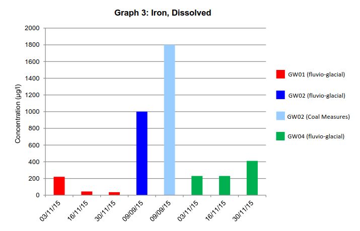
Environmental Setting and Site Design Report                                 Project Reference: Birtley Quarry

Prepared for:
Ibstock Brick Limited

Prepared by:
AECOM Infrastructure & Environment UK Limited
Royal Court
Basil Close
Derbyshire
Chesterfield
S41 7SL
UK

T: +44 (1246) 209221
aecom.com

© 2018 AECOM Infrastructure & Environment UK Limited. All Rights Reserved.

Prepared for: Ibstock Brick Limited                                                                  AECOM
Environmental Setting and Site Design Report   Project Reference: Birtley Quarry

Prepared for: Ibstock Brick Limited                                    AECOM
Environmental Setting and Site Design Report                                                                                       Project Reference: Birtley Quarry

Table of Contents
1.       Introduction .................................................................................................................................................. 9
         1.1       Report Context ................................................................................................................................. 9
         1.1.1 The Operator .................................................................................................................................... 9
         1.1.2 The Agent ......................................................................................................................................... 9
         1.1.3 Site Description and Outline of the Proposed Activity ....................................................................... 9
         1.2       Site Details ..................................................................................................................................... 10
         1.2.1 Site Location and Access................................................................................................................ 10
         1.2.2 Site Classification ........................................................................................................................... 10
         1.2.3 Application Boundaries and Site Security ....................................................................................... 10
         1.2.4 Adjacent Former Waste Management Activity Boundaries ............................................................. 10
         1.3       Site Context .................................................................................................................................... 11
         1.3.1 Local Topography ........................................................................................................................... 11
         1.3.2 Environmental Receptors and Nature Protection Zones ................................................................. 11
         1.3.3 Residential Receptors..................................................................................................................... 12
         1.3.4 Recreational Areas ......................................................................................................................... 12
         1.3.5 Waterways ...................................................................................................................................... 12
         1.3.6 Water bodies................................................................................................................................... 13
         1.3.7 Agricultural or Urban Sites .............................................................................................................. 13
         1.3.8 Industrial and Commercial Sites ..................................................................................................... 13
         1.3.9 The Agency’s position statement on the location of Landfills .......................................................... 13
2.       Source ....................................................................................................................................................... 14
         2.1       Historical Site Development............................................................................................................ 14
         2.1.1 Historical Use of the Land............................................................................................................... 14
         2.1.2 Relevant Historical Areas of Waste Activity..................................................................................... 14
         2.1.3 Other Land Uses ............................................................................................................................ 14
         2.1.4 Incidents ......................................................................................................................................... 14
         2.2       Proposed Development .................................................................................................................. 15
         2.2.1 Proposed Waste Types ................................................................................................................... 15
         2.2.2 Quantity of Material Required ......................................................................................................... 16
         2.2.3 Phasing........................................................................................................................................... 16
         2.2.4 Hydrogeological Risk Screening ..................................................................................................... 16
         2.2.5 Final Landform and After-use ......................................................................................................... 16
3.       Pathway and Receptor............................................................................................................................... 17
         3.1       Published Geology ......................................................................................................................... 17
         3.1.1 Superficial Deposits ........................................................................................................................ 17
         3.1.2 Solid Geology ................................................................................................................................. 17
         3.1.3 Ground Investigations ..................................................................................................................... 17
         3.2       Hydrology ....................................................................................................................................... 17
         3.2.1 Water Courses ................................................................................................................................ 17
         3.2.2 Flood Risk....................................................................................................................................... 18
         3.2.3 Water Quality and Existing Contamination ..................................................................................... 18
         3.2.4 Surface Water Discharge Licences................................................................................................. 18
         3.3       Hydrogeology ................................................................................................................................. 18
         3.3.1 Aquifer Characteristics.................................................................................................................... 18
         3.3.2 Groundwater Flow .......................................................................................................................... 18
         3.3.3 Groundwater Monitoring ................................................................................................................. 19
         3.3.4 Groundwater Quality ....................................................................................................................... 19
         3.4       Man-made Subsurface Pathways ................................................................................................... 21

Prepared for: Ibstock Brick Limited                                                                                                                             AECOM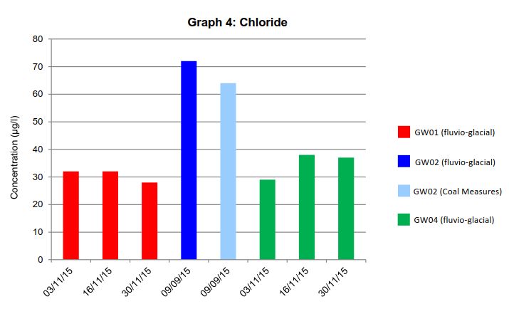
Environmental Setting and Site Design Report                                                                                      Project Reference: Birtley Quarry

         3.5       Receptors and Compliance Points ................................................................................................. 22
         3.5.1 Hydrogeological Risk Assessment .................................................................................................. 22
         Groundwater .............................................................................................................................................. 22
         Surface Water ............................................................................................................................................ 22
         3.5.2 Amenity........................................................................................................................................... 22
4.       Pollution Control Measures ........................................................................................................................ 25
         4.1       Site Engineering ............................................................................................................................. 25
         4.1.1 Buttresses....................................................................................................................................... 25
         4.1.2 Materials and Materials Testing ...................................................................................................... 25
         4.1.3 CQA Requirements ......................................................................................................................... 26
         4.2       Restoration ..................................................................................................................................... 26
         4.3       Surface Water Management ........................................................................................................... 27
         4.3.1 Drainage ......................................................................................................................................... 27
         4.3.2 Existing Surface Water Monitoring Points ....................................................................................... 27
         4.4       Post Closure Controls (Aftercare) ................................................................................................... 28
5.       Monitoring .................................................................................................................................................. 29
         5.1       Weather .......................................................................................................................................... 29
         5.1.1 Obtaining meteorological information ............................................................................................. 29
         5.1.2 Prevailing wind direction and strength ............................................................................................ 29
         5.2       Site Survey ..................................................................................................................................... 29
         5.3       Waste Monitoring ............................................................................................................................ 29
         5.4       Groundwater and Surface Water Monitoring................................................................................... 29
         5.5       Gas Monitoring ............................................................................................................................... 30
6.       Site Condition Report ................................................................................................................................. 31
Appendix ESSD1 Hydrogeological Risk Assessment
Appendix ESSD2 Hydrogeological Interpretive Report
Appendix ESSD3 Surface Water Discharge Permit

Prepared for: Ibstock Brick Limited                                                                                                                            AECOM
Environmental Setting and Site Design Report Project Reference: Birtley Quarry
Figures
Table 1. List of Figures
Drawing Scale Title
D-ESSD1 50,000 Site Location
Detail Site location in relation to surrounding features
D-ESSD2A 10,000 Environmental Site Setting
Detail Site boundary
Residential areas
Schools, hospitals, care homes etc.
Recreational areas
Waterways
Water bodies
Agricultural areas
Urban sites
Roads, railways
Safeguarded aerodromes
D-ESSD2B 10,000 Flood Risk Zones
Flood risk map overlay
D-ESSD3 25,000 Cultural and Natural Heritage
Detail Natural heritage
SSSIs, AONBs, National Parks
SACs, SPAs, Ramsar sites
Cultural heritage
Listed buildings
Scheduled ancient monuments
D-ESSD4 2,500 Site Layout and Waste
Detail Deposition
Cell layout
Filled areas
Existing contours
D-ESSD5A 2,500 Restoration – Final Contours
Detail Final contours
D-ESSD5B 2,500 Proposed Final Scheme Cross Sections
Detail Final cross sections
D-ESSD5C 2,500 Conceptual Quarry Restoration Masterplan
Detail Conceptual quarry restoration masterplan
Landscape planting proposals
Aftercare proposals
D-ESSD6A 2,500 Existing Topography and Geotech Assessment
Detail Existing topography
Security infrastructure (gates and fencing)
Groundwater control
Surface water management features
Infrastructure
D-ESSD6B 2,500 Proposed Earthwork Solution and Cross Sections
Summary of engineering details on a cell by cell basis (possibly in a table on the drawing),
accompanied by schematic cross sections of the proposed layout.
Security infrastructure (gates and fencing)
Surface water management features
Prepared for: Ibstock Brick Limited AECOMEnvironmental Setting and Site Design Report Project Reference: Birtley Quarry
Drawing Scale Title
D-ESSD7 2,500 Gas Monitoring
Detail In waste monitoring points This plan is not required as no gas monitoring
Perimeter/ external monitoring points currently takes place or is required to take place as
part of the recovery operation
D-ESSD8 50,000 Regional Geology
Detail Regional geology (taken from BGS Geological Map)
D-ESSD9 12,500 Regional Hydrogeology
Detail Aquifer classification
SPZs
Licensed and private abstractions from ground and surface water
Springs
Regional groundwater contours (for each ground water body)
Groundwater vulnerability
Off-site groundwater monitoring points (e.g. relevant EA Observation Wells etc)
D-ESSD10 2,500 Local Hydrogeology and Hydrology
Detail Groundwater monitoring points
Local springs
Current surface water discharge points
D-ESSD11 2,500 Hydrogeological Cross Sections
Detail Groundwater levels (for each groundwater body)
Groundwater flow to discharge points
Inter-relationship between; site (base and sides) and groundwater
Groundwater levels and relevant surface water features
D-ESSD12 2,500 Receptors and Pathways
Detail Receptors
Surface water
Groundwater
People (amenity)
Pathways
Air (include wind rose)
Surface water
Groundwater
Drains, pipes etc
Surrounding strata
Appendices
Appendix A-ESSD1 Hydrogeological Risk Assessment
Appendix A-ESSD2 Hydrogeological Interpretive Report
Appendix A-ESSD3 Surface Water Discharge Permit
Tables
Table T-ESSD1 Active Waste Management Sites
Table T-ESSD2 Historic Waste Management Sites
Table T-ESSD3 Industrial Pollution
Table T-ESSD4 Waste Types to be use in Remedial Works
Table T-ESSD5 Summary of groundwater monitoring levels
Table T-ESSD6 Surrounding Land Uses within 500m
Table T-ESSD7 Surrounding Land Uses within 5km
Table T-ESSD8 Proposed Monitoring Parameters and Determinands
Prepared for: Ibstock Brick Limited AECOMEnvironmental Setting and Site Design Report Project Reference: Birtley Quarry
1. Introduction
1.1 Report Context
AECOM has been commissioned by Ibstock Brick Limited (Ibstock) to prepare an application to obtain an
environmental permit for the importation of suitable inert waste materials for quarry stabilisation works located at
Birtley Quarry, Birtley, Chester-le-Street, Gateshead see Figure D-ESSD1.
This document details the environmental and site setting and site design (ESSD) report and supports the
Environmental Permit application. The report should be read in conjunction with other supporting application
information.
1.1.1 The Operator
Ibstock Brick Limited (Ibstock)
Leicester Road
Ibstock
Leicestershire
LE67 6HS
Ibstock Brick Limited is the owner and operator of Birtley Quarry which has operated for many years producing
clay for use at the adjoining Union Brickworks.
1.1.2 The Agent
AECOM Infrastructure and Environment UK Ltd
Royal Court
Basil Close
Chesterfield
S41 7SL
AECOM Infrastructure and Environment UK Ltd is the Agent acting on behalf of Ibstock Brick Ltd.
1.1.3 Site Description and Outline of the Proposed Activity
Birtley Quarry is an operational quarry used for the extraction of clay for brickmaking at the adjacent Birtley Union
Brickworks. Since the late 1990s the former (i.e. non-working) northern and southern quarry faces have suffered
progressive failure due to a combination of historic over-steepening (at a time when the quarry was under
different ownership) and poor drainage. These failures have been managed over the last decade by limited
buttressing and re-profiling of the slopes together with some face drainage. Despite this mitigation continued
movement is occurring.
Recent movements of the northern face could potentially lead to failure of the bank of the River Team, which runs
along the northern boundary of the site and lead to inundation of the site. Further movements of the southern
face could also cause failure of the bank of the Dilworth Beck, a tributary of the River Team, which runs along the
southern boundary of the site and again cause water inflow into the site.
A permanent solution to the stability problems at Birtley is required, which is stable both during on-going clay
extraction and following restoration.
The proposed operations are located within the footprint of the Birtley Quarry area (see Figure D-ESSD4). The
remedial works will include the construction of engineered buttresses on the northern and southern slopes of the
quarry using a total of 268,000 tonnes of imported inert materials and utilising conventional earthworking plant.
The buttresses would be constructed using imported suitable inert waste materials as there are no suitable
materials on-site which are available for this purpose.
It is proposed to undertake the engineered slope stability works over two years. The northern and southern
stability buttresses will be constructed sequentially, with works on the northern slope being undertaken during the
first year and the works on the southern slope undertaken during the second year.
Prepared for: Ibstock Brick Limited AECOM
9Environmental Setting and Site Design Report Project Reference: Birtley Quarry
The activities that will be carried out at the site as defined under Annex II of the Waste Framework Directive can
be summarised as follows:
R11: use of wastes obtained from an operation numbers R1 to R10; and
R13: Storage of waste pending an R11 operation.
1.2 Site Details
1.2.1 Site Location and Access
Birtley Quarry and the adjacent Union Brickworks are both on the outskirts of the community of Birtley - on the
southern fringe of the Tyneside conurbation, approximately half way between Gateshead to the north and
Chester-le-Street to the south (see Figure D-ESSD1).
The site access is from Station Lane, Birtley. This links to the A167 Durham Road to the east – which in turn joins
the A1(T) to the north at Low Eighton or the A693 Blind Lane and the A1(M) at Junction 63 to the south.
The centre of the site is located at National Grid Reference (NGR) NZ 26017 56209.
1.2.2 Site Classification
The site is currently an active quarry.
The proposed operation will involve the importation of suitable inert waste materials for quarry stabilisation works
which is classed as a recovery operation. The proposed development is fully detailed within the Waste Recovery
Plan (WRP) which is contained in Section 4 of the Application.
The proposed recovery activities at the site will be regulated under the Environmental Permitting (England and
Wales) Regulations 2016.
1.2.3 Application Boundaries and Site Security
The installation boundary is shown on Figure D-ESSD2 and is secured by lockable gates and perimeter fencing.
The area of the installation boundary is approximately 19.98ha, and the area where the remedial works will take
place is approximately 4.69ha.
1.2.4 Adjacent Former Waste Management Activity Boundaries
The Environment Agency “What’s in My Back Yard” website contains information regarding current and former
waste management facilities within 500m of the site.
Current waste management activities within 500m of the site are shown in Table T-ESSD1 below.
Table T-EDDS1. Active Waste Management Sites
Active Landfill Details Licence Type Environmental Distance from the
Permit Reference site
Number
Kibblesworth Quarry, Greenford Lane, A04: Household, Commercial & EAEPR\EA/EPR/YP37 20m north west
Kibblesworth, Gateshead, Tyne and Industrial Waste Landfill 97ZR/V007
Wyre, DH2 1BJ
St Bedes Brickworks A01: Co-Disposal Landfill Site EAEPR\EA/EPR/AB32 350m south
09XJ/T001
Prepared for: Ibstock Brick Limited AECOM
10Environmental Setting and Site Design Report Project Reference: Birtley Quarry
Historic waste management activities within 500m of the site are shown in Table T-ESSD2 below.
Table T-ESSD2. Historic Waste Management Sites
Historic Landfill Details First Waste Last Waste Type of Waste Received Distance from the
Received Received site
North Quarry, Station Lane, Birtley 25th January 1991 31st December 1991 Inert 20m south
Industrial
North Quarry No. 1, Station Lane, 2nd August 1981 28th April 1994 Inert 20m south
Birtley Industrial
Commercial
Household
Special
Liquids/Sludges
Birtley Sewage Treatment Works - - - 50m north
rd st
Durham Chemicals, Mary Avenue, 3 April 1978 31 December 1980 Inert 50m east
Chester-le-Street, County Durham Industrial
Commercial
Household
Special
1.3 Site Context
1.3.1 Local Topography
The existing topography within the site is shown in Figure D-ESSD4.
The site is a current mineral working with mineral extraction being undertaken to the west of the site. Topography
in the vicinity of the site rises to the north at Halow Green, to the east within Birtley, and to the west towards
Kibblesworth Common.
1.3.2 Environmental Receptors and Nature Protection Zones
The Environmental site setting is shown on Figure D-ESSD2A and 2B. Environmental receptors within 2km of the
site are shown on Figure D-ESSD3.
Designated Sites
Information regarding designated sites was obtained from the Multi-Agency Geographic Information for the
Countryside (MAGIC) website, and a phase 1 habitat survey was completed as part of previous planning
applications. Information was obtained relating to:
European Nature Conservation Sites;
Special Protection Areas (SPAs);
Special Areas of Conservation (SACs);
RAMSAR sites; and
Sites of Special Scientific Interest (SSSIs).
A search was completed for sites within at least 5km radius of the site. In summary:
there are no SPAs, SACs or Ramsar Sites within 5km of the site;
the closest SSSI to the site is Pockerley Farm Pond, located approximately 3.6km to the south west of the
site; and
the site is not subject of a landscape quality designation, however the site is located within the Great North
Forest.
Prepared for: Ibstock Brick Limited AECOM
11Environmental Setting and Site Design Report Project Reference: Birtley Quarry
Other Sensitive Locations
In addition to the statutory designated sites, a further nine sites with non-statutory designations were identified as
being present within 2km of the Site:
Birtley Union Brickworks Local Wildlife Site (LWS) – 7.5ha of land within the site boundary (east of Rowletch
Burn) consisting of lowland mixed deciduous woodland, ponds and species rich grassland habitats and the
presence of national/local BAP species including Hedge Sparrow, Song Thrush, Hedgehog, Great Crested
Newt and Toad;
the Bowes Valley Nature Reserve LWS - located 20m west of the site boundary and consisting of
grassland, ponds and tree-planted areas on re-claimed clay pit, and supports NERC ACT S41 species,
including dingy skipper as well as the Schedule 1 bird species little ringed plover;
Lamesley Sewage Works Reedbed LWS - located 30m north of the site boundary and consisting of a large
reedbed (the largest in Gateshead), pools and tree planted areas, and supports otter;
River Team Woodlands LWS - located 30m southwest of the site boundary and consisting of ancient
woodland (Urpeth Wood), with ornithological interest and a locally rare plant;
Bowes Railway Line LWS - located 310m north of the site boundary and consisting of a recolonised railway
line with heathland, acid grassland, woodland and a pond;
Long Acre Dene LWS - located 670m northeast of the site boundary and consisting of ancient lowland
mixed deciduous woodland;
Long Acre Wood LWS - located 790m north of the site boundary and consisting of ancient lowland mixed
deciduous woodland and ponds;
Walters Wood, Ouston LWS – located 840m southwest of the site boundary and consisting of diverse
habitats in a stream valley; and
Urpeth Bottoms LWS - located 860m southwest of the site boundary and consisting of ancient lowland
mixed deciduous woodland, grassland and riversides, and supports otter and great crested newt.
1.3.3 Residential Receptors
The closest residential receptors include:
the White House, approximately 20m from the western site boundary;
Berwicke Caravan Park at Urpeth Bridge, approximately 300m to the west of the Site;
Low Urpeth, approximately 490m south west of the Site;
Kibblesworth, approximately 880m north west of the Site; and
Ouston, approximately 900m south of the Site.
1.3.4 Recreational Areas
The closest recreational area is a football ground and open green space approximately 450m to the east of the
site within Birtley.
1.3.5 Waterways
Birtley Quarry is surrounded by surface water courses on three sides of the quarry area:
the River Team (a Major River) runs on a south-west – north-east alignment along the northern boundary of
the site and flows north towards the River Tyne along the Team Valley;
the Rowletch Burn runs on a south-north alignment through the site along the eastern boundary of the
quarry void before joining the River Team on the northern boundary; and
Urpeth Burn, a tributary of the Rowletch Burn, runs on a south-east – north-west alignment along the
southern boundary.
Prepared for: Ibstock Brick Limited AECOM
12Environmental Setting and Site Design Report Project Reference: Birtley Quarry
1.3.6 Water Bodies
The main hydrological feature on site is the flooded quarry sump, located within the quarry void. A further two
ponds are located to the east of the quarry along the eastern side of Rowletch Burn.
1.3.7 Agricultural or Urban Sites
The land to the west and south of the site is mainly in agricultural use.
The nearest settlement is Birtley, approximately 350m to the east of the site. Kibblesworth village is located
approximately 880m to the northwest.
1.3.8 Industrial and Commercial Sites
Industrial and Commercial receptors in the vicinity of the Site include:
Birtley Water Pollution Works to the north of the River Team with Lamsley Combined Waste Water
Treatment scheme beyond;
the West Coast mainline railway line located adjacent to the eastern boundary of the Site; and
Durham Road Trading Estate beyond the railway to the east.
1.3.9 The Agency’s position statement on the location of Landfills
The proposed development is a recovery operation and therefore the Environment Agency’s position statement
on the location of landfills does not apply in this case.
Prepared for: Ibstock Brick Limited AECOM
13Environmental Setting and Site Design Report Project Reference: Birtley Quarry
2. Source
2.1 Historical Site Development
2.1.1 Historical Use of the Land
Historical ordnance survey maps and aerial photographs (supplied by Gateshead Council) were reviewed from
1884 to present day to identify the duration and extent of the clay extraction activities in the area of Birtley
Quarry.
Checks on the historical land use for the site confirm that the proposed remedial works are located within a site
with a history of quarrying operations. Clay extraction from land to the east of the Rowletch Burn began prior to
1898 with excavation to the west of the burn commencing before 1960. Brick manufacture began at Union
Brickworks prior to 1900 and at the neighbouring Team Valley brickworks by 1919.
The laminated clays worked at Birtley Quarry are superficial deposits (drift) of glacio-lacustrine origin and are
used in the manufacture of bricks and related products at the adjoining Union Brickworks.
Clay excavation typically takes place on an annual ‘campaign basis’ over an 8 to 12 week period each spring.
The excavated clay is stockpiled on land to the east of the Rowletch Burn – from which it is drawn in small
quantities on a regular basis to supply the brickworks. Relatively small quantities of reject bricks from the
brickworks manufacturing process are also stockpiled on the land to the east of the Rowletch Burn – prior to
being returned to the quarry void for use on haul roads.
2.1.2 Relevant Historical Areas of Waste Activity
There are no known relevant historical areas of waste activity within the site.
2.1.3 Other Land Uses
There are no known other land uses at the site which may give rise to potential sources of contamination within
the site.
2.1.4 Incidents
The Environment Agency record and classify any reported pollution incidents as major or significant. Based on
the results of the Environment Agency’s website search no reported pollution incidents have occurred within the
proposed installation boundary.
A number of historical incidents involving pollution of controlled waters was identified from the EA website and the
Envirocheck report and is summarised in Table T-ESSD3 below.
Table T-ESSD3 Industrial Pollution
Incident Year Type of Impact Incident Severity Cause of Incident/
Number Pollutant
235/000347 1990 Pollution incident to controlled waters Category 2 – Significant Industrial General Spillage
Incident
235/002510 1994 Pollution incident to controlled waters Category 3 – Minor Incident Sewage
235/002434 1994 Pollution incident to controlled waters Category 3 – Minor Incident Oil
235/002310 1994 Pollution incident to controlled waters Category 3 – Minor Incident Other Cause/not given
NT950223 1995 Pollution incident to controlled waters Category 3 – Minor Incident Miscellaneous – Inert
Suspended Solids
26027 2001 Substantiated pollution incident to water Category 2 - Significant Contaminated Water:
Suspended Solids
626676 2008 Substantiated pollution incident to water Category 2 – Major Incident Sewage Materials
Prepared for: Ibstock Brick Limited AECOM
14Environmental Setting and Site Design Report Project Reference: Birtley Quarry
2.2 Proposed Development
The proposed development is considered in detail in the Waste Recovery Plan and shown on Figures D-
ESSD6B.
A permanent solution to the slope stability problems at Birtley is required, which is stable both during on-going
clay extraction and following restoration. A long term, practicable, cost effective and sustainable solution with
minimal maintenance requirements would be the construction of a retaining buttress on each slope. The
buttresses would be constructed using imported suitable inert waste materials as there are no suitable materials
on-site which are available for this purpose.
This would effectively reduce the slope angle and coupled with a simple water management system such as
interceptors and surface channels, would leave the slopes in a stable condition for the long-term.
The scheme description is described in full in the URS Remedial Works Report (Appendix D of the Waste
Recovery Plan (WRP)). Stabilisation of the northern face is considered to be the most urgently required, given
the proximity of the back scars to the River Team.
The stabilisation works will achieve the following:
a margin between the adjacent watercourses and the top of the quarry slope is at least 10 metres in width in
each case;
a final engineered northern slope no steeper than 1 in 5.5; and
a final engineered southern slope no steeper than 1 in 6.
2.2.1 Proposed Waste Types
The waste types to be used in the slope stabilisation works will be inert waste as defined in Article 2e of Council
Directive 1999/31/EC of 26 April 1999 on the landfill of waste (“the Landfill Directive”). That is:
“[…] waste that does not undergo any significant physical, chemical or biological transformations. Inert waste will
not dissolve burn or otherwise physically or chemically react, biodegrade or adversely affect other matter with
which it comes into contact in a way likely to give rise to environmental pollution or harm human health. The total
leachability and pollutant content of the waste and the ecotoxicity of the leachate must be insignificant, and in
particular not endanger the quality of surface water and/or groundwater.”
The inert wastes to be used are set out in Table T-ESSD4 together with their European Waste Catalogue codes
and which are considered suitable for use in waste recovery operations by the Environment Agency. Subject to
application of suitable waste acceptance procedures at the site these waste types will not pose an unacceptable
risk to the environment (including controlled waters) or human health.
1
T-ESSD4. Waste Types to be used in Remedial Works
EWC Code Description
01 01 Wastes from Mineral Excavation
01 01 02 Wastes from Non-Metalliferous Excavation
01 04 Wastes from Physical And Chemical Processing of Non-Metalliferous Minerals
01 04 08 Waste Gravel And Crushed Rocks Other Than Those Containing Dangerous Substances
01 04 09 Waste Sand and Clays
10 12 Waste from Manufacture of Ceramic Goods, Bricks, Tiles and Construction Products
10 12 08 Waste Ceramics, Bricks, Tiles and Construction Products (After Thermal Processing)
17 01 Concrete, Bricks, Tiles and Ceramics
17 01 01 Concrete
17 01 02 Bricks
1
Extract from Appendix 2 in Environment Agency Regulatory Guidance Series No EPR 13 Defining Waste Recovery:
Permanent Deposit of Waste on Land for typical use “B” Restoration of Mineral Workings
Prepared for: Ibstock Brick Limited AECOM
15Environmental Setting and Site Design Report Project Reference: Birtley Quarry
EWC Code Description
17 01 03 Tiles and Ceramics
17 01 07 Mixtures of Concrete, Bricks, Tiles and Ceramics
17 05 Soil Stones and Dredging Spoil
17 05 04 Other Soil and Stones
19 12 Wastes from the Mechanical Treatment of Waste Not Otherwise Specified
2
19 12 09 Minerals (for example Sand, Stones)
20 02 Garden and Park Wastes (Including Cemetery Waste)
20 02 02 Soil and Stones
2.2.2 Quantity of Material Required
The proposed remedial works at Birtley Quarry will involve the use of the minimum quantity of waste to achieve a
stable and acceptable landform. The methods used for calculating the quantity of material required is detailed in
the WRP.
The total volume of inert materials required to construct the stability buttresses has been calculated using LSS 3-
D terrain modelling software as the difference between the stability buttresses (Drawing 47066723/GEO/R01 in
Appendix D of the WRP) and the existing topography as surveyed in August 2013. The total volume of
engineered material required to construct both buttresses on the northern and southern faces has been
3 3
calculated as approximately 149,000m (or around 267,600 tonnes at a placed density of 1.8 t/m ).
2.2.3 Phasing
The location of the proposed development is shown on Figure D-ESSD4.
It is proposed to undertake the engineered slope stability works over two years. The northern and southern
stability buttresses will be constructed sequentially, with works on the northern slope being undertaken during the
first year and the works on the southern slope undertaken during the second year.
2.2.4 Hydrogeological Risk Screening
A hydrogeological risk assessment is required to demonstrate that the proposed development will be compliant
with the Environmental Permitting Regulations 2010 (as amended) and is included at Appendix A-ESSD1. These
Regulations require that certain substances (hazardous substances) are not discharged to groundwater such that
they are discernible, and that the discharge of other substances (non-hazardous pollutants) is limited so as to
prevent pollution.
There are no direct or indirect discharges to groundwater proposed as part of the activities.
Comprehensive details on the hydrogeological setting of the site has been considered in a number of technical
reports produced by URS/AECOM (see hydrogeological interpretive report at Appendix A-ESSD2).
2.2.5 Final Landform and After-use
The proposed final landform is shown on Figures D-ESSD5A and D-ESSD5B. On completion, the stabilised
slopes will be allowed to colonise naturally as this type of early successional habitat is of ecological value.
In the long-term, once mineral extraction at the quarry and associated dewatering ceases, the restoration scheme
for the quarry (as approved under planning permission DM/14/02371/VOCMW) will be implemented. The
stabilised slopes will form the sides of the flooded quarry and have been designed to be stable in this condition.
2
Excluding residual "fines" from mechanical treatment of mixed wastes at transfer stations
Prepared for: Ibstock Brick Limited AECOM
16Environmental Setting and Site Design Report Project Reference: Birtley Quarry
3. Pathway and Receptor
3.1 Published Geology
For geological information on the site, the British Geological Society (BGS) Drift Maps for Newcastle Upon Tyne,
(Sheet 20) 1:50,000 and the 1:10,560 scale BGS map NZ25NE were reviewed. The geology of Birtley Quarry is
superficial deposits (Glacial Lake Deposits locally overlain by alluvium) which in turn overlie Coal Measures
bedrock. The geology of the site and surroundings are shown on Figure D-ESSD8.
3.1.1 Superficial Deposits
The site is predominantly underlain by Glacial Lake Deposits (Glacio-lacustrine deposits– Clay and Silt of
Devensian age). This is locally overlain by Alluvium associated with the River Team in the north of the site. The
Alluvium consists of soft to firm, compressible silty clay which can contain layers of silt, sand, peat and basal
gravel. The Glacial Lake deposits predominantly consist of laminated clays and silts, which overlie fluvio-glacial
fine sands and gravels, with occasional pebbles beds recorded. The BGS borehole records show that the
superficial deposits in the vicinity of the site area approximately 40 m in thickness with the thickness increasing to
the east, infilling a pre-glacial valley running south to north along the axis of the Team Valley.
Within the former clay pit area historical borehole records identify grey/brown silty Clay (Glacial Lake Deposits)
containing thin bands of silt and fine sand underlying the Made Ground to depths of between 18.45m bgl to
30.2m bgl.
Underlying the Laminated Clay strata deposits of fluvio-glacial Sand, sandy Silt / silty Sand and banded Sands
have been encountered (occasionally containing fine coal fragments).
3.1.2 Solid Geology
The BGS Solid and Drift Map for Newcastle upon Tyne (Sheet 20) 1:50,000 indicates that the underlying solid
geology is the Pennine Middle Coal Measures Formation. This consists of inter-bedded grey mudstone, siltstone,
pale grey sandstone and coal seams. Two coal seams sub-crop within the site boundary with the discontinuities
in the sub-crops indicative of washout due to the presence of the buried valley.
No Geological Conservation Review Sites are identified within 1km of the Site.
3.1.3 Ground Investigations
Ground investigations have been undertaken between 2001 and 2015 and have informed the local geology at the
site and within the immediate vicinity from a number of exploratory boreholes. Local geology at the site is
considered in more detail in the Hydrogeological Interpretive Report included at Appendix A-ESSD2.
3.2 Hydrology
3.2.1 Water Courses
The River Team runs along the northern boundary of the site, merging with Rowletch Burn which runs from the
south eastern boundary across the site to the northern boundary. Dilworth Beck / Urpeth Burn is located along
the southern boundary of the clay extraction area as a tributary to Rowletch Burn. The River Team, once merged
with the Rowletch Burn, flows to the north towards the River Tyne along the Team Valley.
The main hydrological feature on site is the flooded quarry sump, located within the quarry void. Groundwater
and surface water within the quarry void is collected and periodically pumped to the east of Rowletch Burn to an
area of regenerated reed bed in the adjacent Local Wildlife Site before being discharged (Discharge Consent No.
235/1698), via infiltration, to Rowletch Burn (see Appendix A-ESSD3).
A further two ponds are located to the east of the quarry along the eastern side of Rowletch Burn.
Prepared for: Ibstock Brick Limited AECOM
17Environmental Setting and Site Design Report Project Reference: Birtley Quarry
3.2.2 Flood Risk
The quarry void and land immediately adjacent to the River Team and Rowletch Burn lie within the Environment
Agency’s delineated Flood Zone 3 and are therefore deemed at high risk of flooding from fluvial sources.
The remaining site area, to the east and west of the quarry void, is located within the Environment Agency’s
delineated Flood Zone 1 and therefore deemed at low risk of flooding from fluvial sources.
3.2.3 Water Quality and Existing Contamination
The closest watercourse, which is monitored by the Environment Agency, is the River Team located adjacent to
the northern boundary of the site. The Environment Agency gives a Biology Grade C for this watercourse under
the General Quality Assessment (GQA) Scheme. According to the Environment Agency’s River Basin
Management Plan (RBMP), the whole stretch of the River Team has been classified as having a Good chemical
quality and a Moderate potential ecological quality.
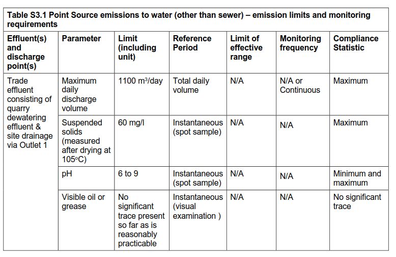
3.2.4 Surface Water Discharge Licences
Ibstock operate a discharge licence located on-site which relates to trade discharge from mineral works to the
Rowletch Burn (see above) and Northumbrian Water Ltd operate a discharge license for storm sewage overflow
to the River Team associated with the sewage works located to the north of the site.
3.3 Hydrogeology
Hydrogeological investigations have been undertaken by AECOM most recently in 2015, see the Hydrogeological
Interpretive report in Appendix A-ESSD2. Regional hydrogeology is shown in Figure D-ESSD9.
3.3.1 Aquifer Characteristics
The superficial deposits of Glacial Lake Deposits across the majority of the site are classified by the Environment
Agency as Unproductive Strata. The superficial deposit of Alluvium located at the northern boundary of the site,
and the underlying bedrock of the Pennine Middle Coal Measures are classed as a Secondary A Aquifers.
The groundwater vulnerability for the whole quarry site is a minor aquifer overlain by soils of low leaching
potential.
There are no Source Protection Zones (Total Catchment – Zone 3) within 5km of the site. Therefore, it is
considered that SPZs will not be impacted by the proposed development as pathways are unlikely to be present.
The EA River Basin Management Plan (RBMP) Northumbria River Basin District currently classifies the
quantitative status of the district wide underlying groundwater as ‘good’ and the chemical status to be ‘poor’.
However, the groundwater chemical status underlying the site within the Pennine Middle Coal Measures
Formation will be poor due to underground coal workings.
There are no surface water or ground water abstractions within 1km of the site.
3.3.2 Groundwater Flow
Shallow groundwater flow within the alluvial deposits will be towards the surface watercourses. Groundwater flow
within the fluvio-glacial sands and gravels is likely to be limited be lateral persistency of the strata, and may
predominantly flow towards the north along the axis of the buried valley, except where influenced by groundwater
flow in the underlying Coal Measures. Groundwater flow in the Coal Measures is strongly influenced by the
presence of an extensive regional network of mined voids, and by the Coal Authority’s network of active, long-
term mine water pumping stations. Mine water is being pumped from the former Kibblesworth Colliery located
around 1.6km to the west of the site. Information obtained from the Coal Authority show that in 2013, mine water
was being abstracted at a rate of approximately 300 l/s and discharged at Lamesley Combined Water Treatment
Scheme to the north of the site. The groundwater level in June 2013 was at a level of 3.0m AOD. Coal Authority
records show that since 2004 the groundwater level has risen by approximately 30 m.
Groundwater levels within the Coal Measures are continuously recorded by the Environment Agency (EA) at a
borehole at Birtley around 500m to the north of the site. The EA state in a letter to Durham County Council dated
th
24 June 2013 that the current groundwater level at the borehole was recorded at 4.2 m AOD in May 2013.
Prepared for: Ibstock Brick Limited AECOM
18Environmental Setting and Site Design Report Project Reference: Birtley Quarry
Although, this may represent a confined (piezometric) groundwater level at a specific point rather than the
unconfined height of the water table across the area.
3.3.3 Groundwater Monitoring
Historic groundwater monitoring has been undertaken periodically at the site since 2001, and most recently in
2015 associated with two planning applications for the slope stabilisation works and quarry deepening (these
have since been decommissioned). The purpose of the ground investigation work was to evaluate the extent and
nature and thickness of the underlying superficial deposits, including the identification of any granular strata
below the Glacio-lacustrine Clays (laminated clays), the depth to rockhead (where possible) and the presence of
groundwater within permeable strata.
The investigation for the quarry consisted of:
four cable percussion boreholes (GW01, GW02, GW03 and GW04),
three standpipe installations to monitor groundwater (GW01, GW03 and GW04);
geotechnical sampling and in-situ testing;
groundwater monitoring (six rounds at weekly intervals);
geotechnical laboratory analysis; and
geo-environmental laboratory analysis of groundwater.
Environmental samples were taken during the course of the investigation for chemical testing.
The groundwater levels from 2015 is summarised in Table T-ESSD5 below and within Figure D-ESSD11.
Table T-EDDS5 Summary of Groundwater Monitoring Levels (in mAOD)
Location Piezometric Level (mAOD) Stratum Screened
(Monitoring Round)
1 2 3 4 5 6
GW01 5.53 5.56 5.81 5.96 5.85 6.17 Fluvio-glacial (Sand)
GW02 (Artesian head in GW02 around 2.10mAOD) Fluvio-glacial (Gravel)
(Artesian head in GW02 around 4.60mAOD) Coal Measures
GW03 -0.23 -0.06 0.61 0.72 1.07 1.17 Fluvio-glacial
(Clay/Sand)
GW04 4.66 4.84 5.09 5.18 5.13 5.36 Fluvio-glacial
(Clay/Gravel)
Groundwater monitoring shows that groundwater heads in boreholes with response zones toward the base of the
fluvio-glacial deposits (i.e. GW01, GW04) (and also in GW02 where artesian water was struck near the base of
the superficial deposits) are between 4 and 6 m AOD. In contrast, groundwater heads recorded in GW03, where
the response zone was near the top of the fluvio-glacial deposits, are lower, around 0 – 1 m AOD. The elevated
groundwater heads deeper in the fluvio-glacial deposits are most likely to result from water at this depth being
confined by layers of low permeability clays within the sands and gravels.
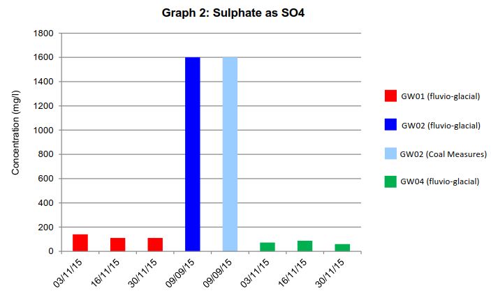
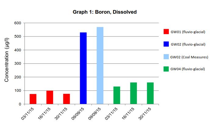
3.3.4 Groundwater Quality
Groundwater samples were obtained from the fluvio-glacial deposits locations GW01 and GW04 during the
monitoring period. Location GW03 contained insufficient groundwater to enable sampling. In addition two “grab”
samples of groundwater were obtained from the groundwater strikes in the fluvio-glacial deposits and Coal
Measures at location GW02.
The samples were analysed primarily for a suite of metals and inorganic determinands to determine whether the
groundwater contained within the fluvio-glacial deposits exhibited a similar chemical profile to groundwater from
the Coal Measures strata which would indicate that they were in hydraulic continuity, and also to determine
whether there was any evidence to suggest that the groundwater had been impacted by underground
mineworkings. The results are shown below.
Prepared for: Ibstock Brick Limited AECOM
19Environmental Setting and Site Design Report Project Reference: Birtley Quarry
Prepared for: Ibstock Brick Limited AECOM
20Environmental Setting and Site Design Report Project Reference: Birtley Quarry
Based upon the chemical analysis of groundwater sampled from both the granular fluvio-glacial deposits and the
underlying Coal Measures, the groundwater within the granular fluvio-glacial deposits is of acceptable quality and
is generally hydrogeologically isolated from the groundwater within the Coal Measures.
3.4 Man-made Subsurface Pathways
There are no known buried services within the quarry as the site is an area of ongoing mineral extraction. A
number of groundwater monitoring boreholes have historically been installed at the site associated with previous
ground investigations, but have been subsequently decommissioned.
A mine shaft associated with historical Coal Authority activities has been identified in previous geotechnical
studies, but there is no evidence of a shaft at the surface. It’s approximately location is shown on Figure D-
ESSD6A.
Prepared for: Ibstock Brick Limited AECOM
21Environmental Setting and Site Design Report Project Reference: Birtley Quarry
3.5 Receptors and Compliance Points
3.5.1 Hydrogeological Risk Assessment
A Hydrogeological Risk Assessment (HRA) has been prepared to assess the risks to groundwater quality
associated with the use of inert waste under the waste recovery permit at the site.
Groundwater
Receptors in relation to groundwater include:
for hazardous substances, the potential receptor has been assumed to be the groundwater directly beneath
the quarry site (prior to any dilution occurring);
for non-hazardous substances, the potential receptor has been assumed to be the shallow groundwater in
alluvium
There are no licenced abstractions within 1km and no water-dependant ecological sites within 2km of the site
which are in good hydraulic connection with the aquifer.
Surface Water
Receptors in relation to surface water include:
the River Team along the northern boundary of the site, which flows north towards the River Tyne along the
Team Valley;
the Rowletch Burn along the eastern boundary of the quarry void before joining the River Team on the
northern boundary;
Urpeth Burn, which runs along the southern boundary;
the flooded quarry sump located within the quarry void; and
a further two surface water ponds located to the east of the quarry along the eastern side of Rowletch Burn.
Assessment
It is recognised that the hydrogeological risk assessment must assess compliance with the requirements of the
Environmental Permitting (England and Wales) Regulations, 2010 (as amended). An evaluation of the potential
risks associated with the site is presented in Table 2.5 of the HRA. It is concluded that the risk posed by
recovered material to shallow groundwater and deep groundwater is considered very low, while that to surface
runoff is considered low.
3.5.2 Amenity
A summary of the potential environmental receptors that are located within the vicinity of the site is presented
within Tables T-ESSD6 and T-ESSD7 and Figures D-ESSD2A and D-ESSD3. Identification of the potential
hazards and risks to these receptors is provided within the accompanying risk assessments.
Table T-ESSD6. Receptors within 500m
Receptor Name Receptor Type Approximate Distance from Drawing Reference
EP boundary (at nearest
point)
Identified receptors within 500m of the installation boundary as shown on Figures D-ESSD2 Environmental
Site Setting
The River Team Surface Water Adjoins northern boundary R1
Rowletch Burn Surface Water Within the site boundary R2
Urpeth Burn Surface Water Adjoins southern boundary R3
Flooded Quarry Sump Surface Water Within the site boundary R4
Surface Water Ponds Surface Water Within the site boundary R5
Birtley Water Pollution Works Industrial/Commercial Adjacent northern boundary R6
Prepared for: Ibstock Brick Limited AECOM
22Environmental Setting and Site Design Report Project Reference: Birtley Quarry
Receptor Name Receptor Type Approximate Distance from Drawing Reference
EP boundary (at nearest
point)
Lamsley Combined Waste Water Ecological 50m north R7
Treatment Works. Lamesley
Sewage Works Reedbed LWS
Durham Road Trading Estate Commercial/Industrial 20m east R8
West Coast Mainline Railway Railway Adjoins eastern boundary R9
Public Footpath 44 (an old Public Right of Way Adjoins south western R10
mineral railway) boundary
Bowes Valley Nature Reserve Ecological 20m north west R11
LWS
Birtley Union Brickworks Local Ecological Within the site boundary R12
Wildlife Site LWS
Bowes Railway Line Ecological 310m north R13
LWS, Scheduled Monument and Scheduled Monument
Public Right of Way Public Right of Way
River Team Woodlands LWS Ecological 30m southwest R14
Agricultural Land Agricultural 20m south west R15
The White House Residential 20m west R16
Bewicke Caravan Park, Urpeth Residential 300m west R17
Bridge
Low Urpeth Residential 490m south west R18
Birtley Residential 350m east R19
Football ground and open green Recreational 450m east R20
space
St Bedes Brickworks Active Waste 350m south R21
Management site
N Quarry and N Quarry No. 1 Historic Waste 20m south R22
Management Site
Durham Chemicals Historic Waste 50m east R23
Management Site
Source: Magic Map accessed February 2018
Table T-ESSD7 Surrounding Land Uses within 5km
Receptor Name Receptor Type Approximately Distance from EP Boundary (at
nearest point)
Nature Protection Areas and Scheduled Monuments within 5km of the installation boundary
Pockerley Farm Pond SSSI Ecological 3.6km south west
Ridley Gill SSSI Ecological 3.7km west
Causey Bank Mires SSSI Ecological 2km west
Chester New Bridge Scheduled Monument 4.1km south
Concangium Roman Fort Scheduled Monument 4.7km south
Site of Ravensworth Coalmill, Scheduled Monument 3.6km north west
600m east of Ravensworth Castle
Ravensworth Quadrangular Scheduled Monument 3.8km north west
Castle
Colliery Engine House at Scheduled Monument 4km north east
Washington F Pit, Albany
Source: Magic Map accessed February 2018
Prepared for: Ibstock Brick Limited AECOM
23Environmental Setting and Site Design Report Project Reference: Birtley Quarry
The location and distribution of sensitive features in relation to the site including habitats, and possible pathways
are considered in the Impact Assessment which accompanies the permit application (see Section 5 of the
Application). They are also shown on Figure D-ESSD12.
The assessment concludes that potential hazards from the proposed remedial works are not likely to be
significant and no further assessment is required.
Prepared for: Ibstock Brick Limited AECOM
24You can also read