Spatial variability of Sr isotope of Gomati River Basin within Ganga Alluvial Plain: Implications for global seawater fluxioning - terrapub
←
→
Page content transcription
If your browser does not render page correctly, please read the page content below
Geochemical Journal, Vol. 54, pp. 57 to 70, 2020                                                             doi:10.2343/geochemj.2.0582

Spatial variability of Sr isotope of Gomati River Basin within Ganga Alluvial Plain:
                    Implications for global seawater fluxioning

                                             SANDEEP SINGH1* and MUNENDRA SINGH2

                 1
                     Department of Earth Sciences, Indian Institute of Technology Roorkee, Roorkee-247 667, India
                             2
                               Department of Geology, University of Lucknow, Lucknow-226 007, India

                                        (Received August 21, 2018; Accepted January 25, 2020)

         The continuous increase of the 87Sr/86Sr isotopic ratio in the seawater since last 40 Ma has been correlated with the rise
    of the Himalaya. The Ganga-Brahmputra Fluvial System drains the Himalaya along with the Ganga Alluvial Plain (GAP)
    and the northern Indian Craton regions. Under the humid subtropical climatic condition, the rivers of the alluvial plain
    contribute a significant (~50%) in the water discharge. Previous studies have identified the Himalayan Rivers as a poten-
    tial source for the steady increase of marine Sr budget; overlooking the contribution of alluvial rivers. We attempt to
    constrain the role of GAP as a source for Sr. The Gomati River, a 900 km-long tributary of the Ganga River, drains about
    30,437 km2 of the GAP with 7,390 ¥ 106 m 3/a water discharge and provides an ideal opportunity to understand the role of
    GAP in contribution of the global 87Sr budget. A total of 44 river water, 33 groundwater, 6 rainwater, 3 lake water, and 13
    alluvial sediment samples were analyzed for 87Sr/ 86Sr isotopic ratio to determine sources and mixing relationships of the
    rainwater, groundwater and river water within the GAP.
         In the Gomati River Basin, the average Sr isotopic ratio of the river water (0.7292) is higher than that of the average
    Ganga River water (0.7246) and much higher than that of world seawater (0.7119) and modern seawater (0.7092). The
    average Sr isotopic ratio of the shallow groundwater and rainwater was 0.7242 and 0.7139, respectively. The Gomati
    River drains the GAP having alluvial sediments with more radiogenic Sr isotopic ratio ranging from 0.7655 to 0.7244.
    Due to this, the river water displays strong seasonal variability with lower Sr isotopic ratio than groundwater during the
    monsoon season (0.7184). Our data indicate that the high water discharge contribution with reasonably higher Sr isotopic
    values from GAP river water makes it an important additional source of high radiogenic Sr in addition to the Himalayan
    source. The chemical weathering of alluvial sediments in GAP under the monsoon-controlled climatic condition is likely
    to make significant contributions to the evolution and budget of Sr isotope in the global sea.

                       Keywords: Himalaya, Ganga Foreland Basin, Ganga Alluvial Plain, Gomati River Basin, Sr isotope

                                                                         ther in the Ganga Delta or in the Bengal Deep-Sea Fan
                          INTRODUCTION
                                                                         regions (Fig. 1A).
    An interesting spectacular landscape after a continen-                   The geometry of the Ganga Foreland Basin is con-
tal collision between the Indian and Asian Plates causing                trolled by flexural subsidence related to Himalayas with
formation of the Himalayas no later than 57 Ma (Leech                    the depo-center located close to front (Mungier and
et al., 2005) is the Indo-Ganga-Brahmaputra Fluvial Sys-                 Huyghe, 2006). Geophysical data indicate (Srinivas et al.,
tem and the Ganga Alluvial Plain (GAP), the middle part                  2013; Mangalik et al., 2015 and references therein) the
of the Indo-Ganga-Brahmaputra Plain which is the world’s                 presence of transverse ridges and saddles (e.g., Delhi-
largest alluvial tract. This is a result of compressional                Haridwar Ridge; Dholpur Saddle; Faizabad Ridge; Meja
tectonics during Early Miocene and expended in Middle                    Saddle) along with northern depressions (e.g., the Sharda
Miocene and reached present day configuration (Singh,                    Depression; the Bahraich Depression; the Gandak Depres-
1996). According to Singh (1996), the GAP is in a ma-                    sion). The northern depressions are associated with
ture stage of the evolutionary cycle of the Ganga Fore-                  graben-like structures (Manglik et al., 2015). The
land Basin which had continuous supply and filling up of                 magnetotelluric profile (Manglik et al., 2015) along a 285
the sediments from Himalaya by fluvial process. Weath-                   km transverse running close to Lucknow across GAP
ering products of the GAP are further transported down-                  along with receiver functions of BroadBand Seismic sta-
stream by alluvial rivers and subsequently deposited ei-                 tions (Srinivas et al., 2013) indicate that southern end of
                                                                         the basin have thin veneer of sediment (~200 m thick)
*Corresponding author (e-mail: san662005@gmail.com)                      which gradually increase to 500–600 m around Kanpur
Copyright © 2020 by The Geochemical Society of Japan.                    to 1.2 km to 2.5 km near Lucknow (Fig. 1B). Further, the

                                                                    57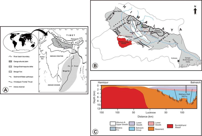
Fig. 1. (A) The Ganga River System with prominent geomorphic features of the Indian sub-continent. (B) The Ganga Foreland
Basin showing the Ganga Alluvial Plain and the Gomati River Basin along with its basement structures. The Gomati River basin
covers the southern part of the Sarda Depression and crosses the Faizabad Ridge, the north-eastern extension of the Bundelkhand
Massif (B) Geological cross-section along Hamirpur-Bahraich of the Ganga Foreland Basin across the Ganga Alluvial Plain.
(redrawn after Manglik et al., 2015).

thickness of sediment rapidly increases to about ~4 km           changes during the late Quaternary (Singh, 1996; Shukla
close to the Himalayan Front with Grabben like struc-            et al., 2001; Tandon et al., 2006; Srivastava and Shukla,
tures.                                                           2009).
    The GAP accumulated sediments during Cenozoic                    Tropical fluvial systems play an important role in char-
from various lithologies of Himalayas as well as from            acterizing the worldwide elemental cycles as they are re-
Peninsular India (Shukla et al., 2012). Weathering is as-        sponsible for the 50% global water discharge to oceans
sociated with removal of minerals followed by erosion            and cover only 25% of the earth’s surface (Meybeck,
and sedimentations, which is controlled by climatic and          1987). The process of the recycling of Himalayan
tectonic conditions of the source. In the GAP, weathering        sediments also led to the pronounced monotonic rise of
                                                                 87
processes are largely controlled by lithology, climate and          Sr/86Sr ratio in seawater since last 40 Ma (Raymo et
monsoonal patterns (Singh et al., 2005, 2007). Physical          al., 1988; Edmund, 1992; Richter et al., 1992; Plamer
and chemical weathering is of the moderate-intensity be-         and Edmund, 1992). The 87Sr/ 86Sr ratio of Himalayan
cause of temperature variation with annual rainfall con-         Rivers is 0.7210 for the Brahmaputra and 0.7257 for the
ditions and is also responsible for elemental distribution       Ganga (Palmer and Edmond, 1989) or 0.7236 (Richter et
within GAP (Singh et al., 2007). The weathering proc-            al., 1992) or 0.7213 (Krishnaswami et al., 1992). It is
esses are also responsible for elemental distribution within     much higher compared to the average 87Sr/86Sr ratio of
GAP. The geomorphological character clearly indicates            river worldwide is 0.711 (Palmer and Edmond, 1989,
evolution under changing climatic conditions, intra- and         1992; Harris, 1995; Galy et al., 1999). Therefore, maybe
extra-basinal tectonics and sea-level induced base-level         considered that the rivers draining the Himalayan region

58   S. Singh and M. Singh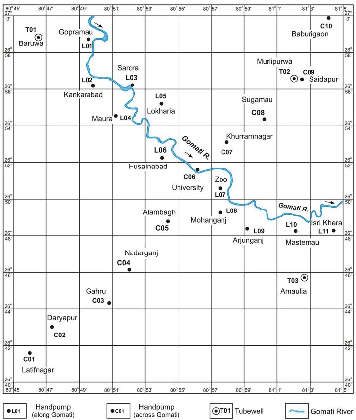
have higher 87Sr/86Sr ratios. However, Singh et al. (2010)
S TUDY AREA
reported 87Sr/86Sr ratios of the Gomati River basin ranges
between 0.7232 during the pre-monsoon season and The GAP is located in the south of the Himalaya re-
0.7370 for the post-monsoon season concluded from 4 gion and is characterized by high agricultural productiv-
samples. ity to support its exponentially growing human popula-
The Sr isotopic budget is a cumulative result of li- tion. It is an alluvial part in the continental drainage of
thology, degree of physical and chemical weathering ex- the Ganga Fluvial System and is characterized by its low
perienced by the source area and subsequent changes elevation (500 persons/km2).
Himalayan rivers like; the Ganga, the Brahmaputra, the They are also characterized by eroded and incised fluvial
Yamuna and part of the Indus, all flowing along the south- terraces which is deeper upstream, close to mountain
ern slopes, have increased in the marine Sr after the front. Geologically, GAP is mainly formed by sediments
Himalayan collision during Cenozoic period derived from the Himalayan region during Late Quater-
(Krishnaswami et al., 1992; Singh et al., 1998; English nary. The uppermost part of the sediment succession in
et al., 2000; Karim and Veizer, 2000; Bickle et al., 2001; the basin is made-up of inter-layered 1–2 m thick fine
Dalai et al., 2003). The Sr isotopic composition of the sand and silty mud deposits with discontinuous calcrete
river is a good tracer to understand the weathering and to horizons (Singh et al., 1999). These sediments are con-
determine Sr budget determination (Dalai et al., 2003). sidered as the source material which undergoes the in-
The Sr flux can be attributed to either silicate weathering tense chemical weathering processes controlled by the
(Galy et al., 1999) or carbonate weathering (English et monsoonal precipitation, extreme annual temperature
al., 2000). However, the silicate weathering is responsi- variation and mineral composition of the alluvial
ble for Sr contribution as compared to carbonate weath- sediments (Singh et al., 2010).
ering. and Sr isotopic ratios indicate the weathering rates The GRB is an alluvial river basin in the north-west-
(Miller et al., 1993; Probst et al., 2000; Stewart et al., ern part of GAP and drains 30,437 km2area, located be-
2001). The isotopic variations of Sr also provide natural tween 25–29∞N and 80–84∞E in the interfluve region of
fingerprinting of soil-water interaction (Pett-Ridge et al., the Ganga and Ghaghara rivers (Fig. 2). It encompasses
2009; Mikova, 2012) as 87Sr/ 86Sr isotopic ratio cannot an altitude range of 190 m to 60 m above mean sea level.
fractionate in low-temperature geochemical reactions or The Gomati River is a groundwater-fed river with its en-
biotic processes (Shand et al., 2007). tire drainage basin lying within the GAP. It originates from
Sr isotopic characteristics of the Gomati River Basin the Madho Tanda located about 50 km south of foothills
(GRB) from an alluvium sequence in temporary storage of the Himalaya. It extends about 900 km before joining
of ~50 ka under a humid tropical climate will give infor- the Ganga River near Saidpur. The tributaries of the
mation on the GAP weathering processes. The Ganga Gomati River are also groundwater-fed supported by the
River drains part of the Himalaya and stands out from monsoonal precipitation. They include the Sai River
other rivers in having high 87Sr/86Sr ratio. It also drains (draining about 1/3rd area), Kathna Nadi, Sarayan Nadi,
the GAP and part of northern Indian Craton. Here, we Jokhan River, Bhainsi Nadi, Chiyya Nala, Kalyani Nadi,
combine new isotopic data of a river basin of the GAP Rethi Nadi, Behta Nala, Pili Nadi, Loni Nadi, Kundu Nala
with their hydrology inputs to provide a reconstruction and the Athhi Nala etc with drainage density ranging from
of radiogenic Sr Flux of the Ganga River. Interaction be- 0.37 to 1.04 km/km 2 . Along the Gomati River, a
tween groundwater and surface water is complex and de- tectonically driven incision has been superimposed over
pends on many factors including landforms, geology, cli- the base level linked incision (Thakur et al., 2009).
mate and the exploitation of local water resources. The The GRB experiences a humid subtropical climate
hydrology and water quality of rivers are strongly con- with four distinct seasons i.e. summer (March–May),
trolled by exchange of water and solutes with adjacent monsoon (June–September), post-monsoon (October–
river banks and uplands. During recharge, groundwater November) and winter (December–February). Total an-
acquires Sr and while moving along the flow path it in- nual rainfall in the basin is about 1025 mm and nearly
teracts with Sr-bearing minerals within the geological 70–80% of it occurs in the monsoon season. The major-
units. ity of rainfall is concentrated in the monsoon season from
The present work is an attempt to generate Sr isotopic July to October with only few sporadic rains during the
data from surface water, groundwater, rainwater and sedi- winter season. Within the GRB variation in temperature
ment profile of GRB within the GAP. We investigated is as high as 47∞C in the summer season while it becomes
the correlations of these components in the contribution about 2∞C during the winter season (Singh et al., 2005).
to the evolution and budget of Sr isotopic flux in global About 75% of rainfall in the GRB is either returned to
seawater. atmosphere through evaporation/evapotranspiration and/
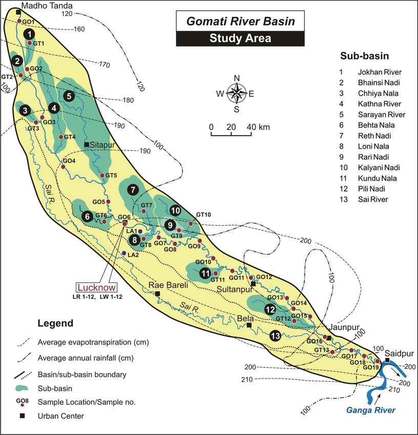
Sr isotope of Gomati River Basin within Ganga Alluvial Plain (GAP) 59Fig. 2. Map of the Gomati River basin, draining a ~30,000 km 2 interfluve area of the Ganga and the Ghaghara Rivers in the Ganga Alluvial Plain. The river basin includes the Sai River as the main tributary and 12 other tributaries. Location of sampling sites for river water collected from the Gomati River (G01-G019) and its tributaries (GT01-GT13). Lucknow monitoring area was selected for sampling of shallow groundwater for the present study. or stored as groundwater. In the monsoonal season, the value. river discharge increases manifold due to heavy rainfall The river receives its water and sediments within the and diminishes afterward. The river hydrology is charac- GAP and GRB transports weathering products as bedload, terized by high discharge (>600 m3/s) during the monsoon suspended load and dissolved load sediments. Bedload season and extremely low discharge (30 m3/s) during the Sediments of the Gomati River are basically very fine summer season. More than 75% of annual discharge oc- sand and mineralogically composed of quartz (55%), rock curs during the monsoon and post-monsoon seasons (June fragments (19%), mica (17%) and feldspar (9%). Illite is to November) (Singh et al., 2013). The river water is clas- the dominant clay mineral (Kumar and Singh, 1978). sified as Ca-Mg-HCO3 type water with average 8.0 pH 60 S. Singh and M. Singh
Table 1. Sr isotopic data of water collected during the winter season from the Gomati River (GO) and its major tributaries (GT) along with Lake
(LW). (N) and (S) mean northern and southern tributaries of the Gomati River. Refer Fig. 2 for the location of sampling sites.
S. No. Sampling date Elevation 87
River Location Latitude Longitude D.D./ Conflu. Sr/86Sr Sr (ppm)
(dd/mm/yy) (m a.s.l.)
(km)
GO01 06/02/06 Gomati River Madho Tanda 185 28°38´ N 80°08´ E 0 0.73327±3 110
GO02 06/02/06 Gomati River Khutar 160 28°09´ N 80°12´ E 145 0.73416±2 154
GO03 06/02/06 Gomati River Maigalganj 148 27°44´ N 80°16´ E 175 0.72793±4 219
GO04 06/02/06 Gomati River Naimesarayan 128 27°21´ N 80°24´ E 245 0.73065±2 323
GO05 06/02/06 Gomati River Itaunja 111 27°03´ N 80°51´ E 335 0.73006±2 329
GO06 04/02/06 Gomati River Lucknow 106 26°54´ N 80°53´ E 366 0.73075±2 327
GO07 04/02/06 Gomati River Gangaganj 101 26°43´ N 81°13´ E 415 0.73016±6 381
GO08 31/01/06 Gomati River Haidergarh 100 26°39´ N 81°24´ E 476 0.72773±2 411
GO09 31/01/06 Gomati River Bazar Sukul 95 26°37´ N 81°37´ E 536 0.72794±5 391
GO10 31/01/06 Gomati River Thauri 90 26°30´ N 81°45´ E 582 0.72877±3 385
GO11 31/01/06 Gomati River Isauli 87 26°24´ N 81°52´ E 604 0.72811±8 394
GO12 31/01/06 Gomati River Sultanpur 83 26°16´ N 82°05´ E 660 0.72963±3 383
GO13 31/01/06 Gomati River Chanda 81 26°07´ N 82°22´ E 726 0.72881±5 379
GO14 01/02/06 Gomati River Dhakwa 80 26°01´ N 82°24´ E 741 0.72789±3 361
GO15 01/02/06 Gomati River Badlapur 79 25°58´ N 82°33´ E 759 0.72796±4 366
GO16 01/02/06 Gomati River Jaunpur 77 25°45´ N 82°44´ E 808 0.73036±5 362
GO17 01/02/06 Gomati River Kirakat 71 25°38´ N 82°55´ E 844 0.72754±3 340
GO18 01/02/06 Gomati River Chandwak 70 25°35´ N 83°00´ E 861 0.72762±2 342
GO19 01/02/06 Gomati River Kaithi 69 25°30´ N 83°08´ E 900 0.72754±3 336
GT01 06/02/06 Jokhan River Puranpur 172 28°22´ N 80°12´ E 66 (N) 0.73403±2 125
GT02 06/02/06 Bhainsi Nadi Pawayan 157 28°07´ N 80°09´ E 92 (N) 0.73343±2 145
GT03 06/02/06 Chhiya Nala Pawayan 152 27°46´ N 80°14´ E 161 (N) 0.72903±2 412
GT04 06/02/06 Kathna River Pisawan 141 27°39´ N 80°28´ E 215 (N) 0.73038±2 393
GT05 06/02/06 Sarayan River Sindhauli 124 27°16´ N 80°18´ E 309 (N) 0.72995±4 385
GT06 04/02/06 Behta Nala Kakori 120 26°54´ N 80°47´ E 360 (S) 0.72549±2 166
GT07 31/01/06 Reth Nadi Barabanki 117 26°55´ N 81°10´ E 422 (N) 0.72668±2 320
GT08 04/02/06 Loni Nala Gangaganj 114 26°44´ N 81°11´ E 431 (S) 0.72528±2 374
GT09 31/01/06 Rari Nadi Haidergarh 109 26°43´ N 81°27´ E 514 (N) 0.72751±5 294
GT10 31/01/06 Kalyani Nadi Ramsanehighat 107 26°47´ N 81°33´ E 514 (N) 0.72989±6 219
GT11 31/01/06 Kundu Nala Musafirkhana 104 26°24´ N 81°16´ E 597 (S) 0.73070±6 295
GT12 01/02/06 Pili Nadi Badlapur 82 25°55´ N 82°29´ E 780 (S) 0.72710±4 132
GT13 01/02/06 Sai River Jalalpur 73 25°38´ N 82°45´ E 830 (S) 0.72716±4 285
LW-A 04/02/06 Mesa Tal Gosaiganj 109 26°48´ N 81°06´ E - 0.72685±6 298
Sr isotope of Gomati River Basin within Ganga Alluvial Plain (GAP)
LW-B 04/02/06 Nawabganj Nawabganj 123 26°37´ N 80°24´ E - 0.72850±2 257
61
LW-C 06/02/06 Naimesaryan Naimesaryan 144 27°21´ N 80°30´ E - 0.72906±2 241Table 2. Sr isotopic data of groundwater from deeper tube wells (T) and shallower hand-pumps (L and C) around Lucknow
area from the Gomati River Basin of the Ganga Alluvial Plain (GAP). Refer Fig. 3 for the location of sampling sites.
87 86
S. No. Sampling Sampling date Longitude Latitude Sr (ppm) Sr/ Sr
location (dd/mm/yy) Isotopic ratio
T-01 Baruwa 27.05.10 80°46´30˝ E 26°58´40˝ N 315 0.72552±5
T-07 Murlipurwa 26.05.10 81°02´10˝E 26°56´40˝ N 378 0.72436±5
T-09 Amaulia 08.06.10 81°03´10˝E 26°43´30˝ N 734 0.72550±6
C-01 Latifnagar 04.06.10 80°46´20˝E 26°41´20˝ N 275 0.72473±5
C-02 Daryapur 04.06.10 80°47´20˝E 26°43´20˝ N 419 0.72188±6
L-01 Gopramau 27.05.10 80°49´20˝E 26°58´40˝ N 288 0.72570±9
L-02 Kankarabad 27.05.10 80°50´20˝E 26°56´20˝ N 610 0.72545±9
C-03 Gahru 07.06.10 80°50´40˝E 26°44´30˝ N 533 0.72125±6
L-03 Sarora 26.05.10 80°52´30˝E 26°56´20˝ N 233 0.72688±4
L-04 Maura 27.05.10 80°51´20˝E 26°54´30˝ N 535 0.72554±5
C-04 Nadarganj 07.06.10 80°51´20˝E 26°46´20˝ N 1434 0.72149±5
L-05 Lokharia 27.05.10 80°54´00˝E 26°55´20˝ N 171 0.72916±6
L-06 Husainabad 27.05.10 80°54´20˝E 26°52´20˝ N 1890 0.72131±7
C-05 Alambagh 08.06.10 80°54´30˝E 26°48´40˝ N 1229 0.72259±9
C-06 University 09.06.10 80°56´20˝E 26°51´40˝ N 651 0.72543±7
C-07 Khurramnagar 28.05.10 80°50´00˝E 26°53´20˝ N 410 0.72467±6
L-07 Zoo 08.06.10 80°57´20˝E 26°50´40˝ N 914 0.72263±5
L-08 Mohanganj 08.06.10 80°58´20˝E 26°48´40˝ N 537 0.72218±5
C-08 Sugamau 28.05.10 81°00´20˝E 26°54´30˝ N 461 0.72434±10
L-09 Arjunganj 08.06.10 80°59´30˝E 26°48´40˝ N 542 0.72228±5
C-09 Saidapur 26.05.10 81°02´20˝E 26°56´30˝ N 521 0.72474±6
L-10 Mastemau 08.06.10 81°02´20˝E 26°48´30˝ N 373 0.72470±6
C-10 Baburigaon 26.05.10 81°04´20˝E 26°59´40˝ N 525 0.72476±6
L-11 Isri Khera 08.06.10 81°04´30˝E 26°48´30˝ N 567 0.72252±6
samples have also been collected during the monsoon
SAMPLING AND A NALYTICAL METHODS
season in July 2011 and the winter season in January 2012
River water, lake water, groundwater, and rainwater from the roof of the Geology Department of Lucknow
samples have been collected for the present Sr isotopic University (Fig. 3). The 4.6 m-high cliff section along
studies. Water samples of the Gomati River (GO1-GO19), the Behta Nala (a small alluvial tributary of the Gomati
and its tributaries (GT1-GT13) and three lakes (LW-A, River) was exposed at Malihabad near Lucknow. A set of
B, and C) were collected during the winter season in Janu- 13 sediment samples were collected from the exposed
ary–February 2006 (Table 1 and Fig. 2). Further twenty- alluvial sequence and precautions have been taken not to
one shallow groundwater samples (C01-10 and L01-11) include calcrete portions for the present study.
from handpump and three (T01-03) from tubewell have All water samples were collected in pre-cleaned
been collected around Lucknow monitoring area, which polypropylene bottles filled with deionized water. At the
is about 360 km downstream of origin of Gomati River time of each sample collection, the deionized water was
and meanders for about 12 km, during May–June 2010 in decanted and washed with river water two to three times
grid fashion (Table 2 and Fig. 3). A monthly time series and then the water samples collected and immediately
samples of the Gomati River water (CRN-1 to 12) and acidified with 1 ml of 1:1 ultrapure HCl. All samples were
shallow groundwater (CGN-1 to 12) have also been col- brought to Indian Institute of Technology Roorkee for
lected from Chandwak between August 2009 and May laboratory analysis. These samples were filtered in the
2010 (Table 3). Along with this, six-time series rainwater laboratory using 0.45-micron nitrate membrane filter in
62 S. Singh and M. SinghFig. 3. Lucknow Monitoring Area showing the location of sampling sites for shallow groundwater along (L01–L10) and across
(C01–C11) the Gomati River. Refer Fig. 2 for location in central part of the Gomati River Basin.
the laminar flow environment. The filtrate was taken in for further processing. Sediment samples were homog-
another pre-cleaned acid-washed polyethylene bottles. enized and pulverized in the agate mortar and put in a
All sediment samples were collected in a polythene clean beaker for the treatment with Hydrogen Peroxide
bag and brought to the Indian Institute of Technology (50%H2O2 + 50% Milli-Q water). Samples along with
Rookee for laboratory analysis. Samples were re-exam- Hydrogen Peroxide were heated up to 80–90∞C for 10–
ined in the field and samples with calcrete were avoided 12 hours to remove the organic matter present in the pow-
Sr isotope of Gomati River Basin within Ganga Alluvial Plain (GAP) 63Table 3. Time Series Sr isotopic data of water from the Gomati River and
groundwater collected at Chadwak of the Ganga Alluvial Plain (GAP). (CRN
= Chandwak River water Natural; CGN = Chandwak Groundwater Natural).
Refer Fig. 2 for the location of Chandwak (GO18) in the Gomati River Basin.
Table 4. Sr isotopic data of rainwater collected during the monsoon and the winter seasons at Lucknow
in the Gomati River Basin of the Ganga Alluvial Plain (GAP). Refer Fig. 2 for the location of Lucknow
(GO06) in the Gomati River Basin.
dered sample. Proper precautions were taken during the dissolved solution was transferred into a 2.0 ml centri-
treatment, effervesce were avoided. fuge tube and centrifuged. 1.0 ml of the supernatant so-
Dried sediment samples were dissolved with lution from the top portion of the centrifuge tube was
HF+HNO 3 acid treatment and dissolved samples were taken and loaded onto the preconditioned Rb-Sr ion-ex-
brought into 2N ultrapure HCL and dissolved. However, change of Bio-Rad AG 50 X 8, 200–400 mesh H+ form
for water 100 ml of acidified water were dried at 90∞C cation exchange resin in 6 mm ID silica glass columns to
and residue were dissolved into 2N ultrapure HCl. The obtain Sr by eluting with 2N HCl. Sr fraction was col-
64 S. Singh and M. SinghTable 5. Sr isotopic data of the Cliff section on the right valley
margin of the Behta Nala tributary of the Gomati River. Refer
Fig. 2 for location of the Behta Nala sub-basin (GT06).
Fig. 4. Longitudinal variations in the Sr isotopic (87Sr/86Sr)
ratio in the water of the Gomati River (line with dot) and its
tributaries (bar). Refer Fig. 2 for sample location in the Gomati
River Basin. Note the higher Sr isotopic ratio in river water of
the uppermost part of the basin. Refer Table 1 for data.
The 87Sr/86Sr isotope ratios of the water and sediment
lected between 24 and 34 ml in the Savillex beaker. The samples of the GRB are presented in Tables 1 to 5.
eluted Sr fraction was evaporated to dryness. 1 m l of wa-
ter was added to the dried sample and dissolved the Sr
RESULTS AND DISCUSSIONS
fraction. The dissolved fraction was subsequently loaded
in pre-conditioned single degassed W filament with 1 ml River water and lake water in the GRB
of TaF5 solution, having 1% Ta in the solution (Birck, The 87Sr/86Sr isotopic ratio in the water of the Gomati
1986). The isotopic measurements of the samples have River, its tributaries and the lakes are presented in Table
been carried out in the Thermal Ionisation Mass 1. All reported values of the 87Sr/86Sr ratio are signifi-
Spectrometer, TRITON T1 at National facility at Indian cantly higher than modern seawater value (0.7092 -
Institute of Technology Roorkee. The TRITON of this Meknassi et al., 2018). The 87Sr/ 86Sr isotopic ratio of
laboratory has 9 Faraday collectors and one electron mul- Gomati River water ranges from 0.7342 (closer to its ori-
tiplier permitting measurements of all the isotopes plus gin) to 0.7275 (near confluence with the Ganga River)
interfering isotopes for the element of concern in a single and its tributaries yield values from 0.7340 to 0.7252 (Fig.
static integration. Sr isotopic composition was measured 4). The value starts from 0.7333 and at the confluence of
in static multi-collector mode with uncertainties better Jokhan River (Khutar) it increases to 0.7342, whereas,
than 10 ppm. During a static multi-collection data acqui- the headwork of Jokhan River has value of 0.7340. As
sition is done in 10 blocks of 40 cycles each giving a River flows down the value goes to 0.7279 at Maigalganj
total of 400 measurements for each isotope. The amplifi- then they further increase to 0.7307 due to inflow of wa-
ers are rotated among the Faraday cups between the ter from Chiya Nadi and Kathana Nadi. Further down-
blocks. In general, 4 s integration time and 3 s of settling ward, the value further decreases to 0.7301 at Itonja as
time are allowed using TRITON software supplied by the water from Sarayan River has lower Sr isotopic ratios
firm. This makes the data acquisition fast and eliminates (0.7299). Further down the value increases to 0.7308 (at
the amplifier gain differences. The reproducibility of the IIM, Lucknow), which reduces to 0.7302 at Gangaganj.
data has been checked by analyzing the NIST SRM 987 This value further reduces to 0.7277 (at Haidergarh) and
several times. The obtained value for 87Sr/86Sr of SRM remains the same (within error limit) to 0.7279 (at Bazar
987 agreed each time with the recommended value within Sukul). At Thakuri it increases a bit to 0.7281 may be
the precision of the mass spectrometer (about 5 ppm). due to water inflow from Kundu Nala having isotopic ra-
The average value for 87Sr/86Sr of SRM 987 during the tio of 0.7307 (at Musafirkhana). The value further in-
period of analysis was 0.71028 ± 10 (n = 30, 1s). The creases to 0.7288 (at Sultanpur). As the river flows down
total procedure blank in the laboratory is less than 8 ng. the value further decreases to 0.7279 to 0.7280 (within
Sr isotope of Gomati River Basin within Ganga Alluvial Plain (GAP) 65Fig. 5. Variation of Sr isotopic (87Sr/86Sr) ratio in shallow
groundwater collected from (A) across and (B) along the Gomati
River at Lucknow Monitoring Area. Refer Fig. 3 for sampling
locations along and across the Gomati River at Lucknow. Note
the Sr isotopic variation linked with geomorphology (Gomati
River Valley) and structural element (Lucknow Fault) of the
Gomati River Basin. Refer to Table 2 for data.
Fig. 7. Seasonal variation in Sr isotopic (87Sr/ 86Sr) ratio of
river water (open square) and groundwater (open circle) in the
Gomati River at Chandwak. Refer Fig. 2 for the location of
Chandawak (G018). Note the monsoon effect in river water and
stable values of groundwater. Refer Table 3 for data.
Fig. 6. Sr isotopic ( 87Sr/ 86Sr) ratio in rainwater collected dur-
ing the monsoon (n=4) and winter (n=2) seasons from Lucknow.
Refer to Table 5 for data. (2005). The higher value of the Naminsharanyan Lake
water than other two lakes may be due to its close prox-
imity of Lucknow Fault located within the alluvium plain
error limit) at Dhakwa and Badlapur respectively. This (Fig. 1). The 87Sr/ 86Sr isotopic ratios from Gomati River
value increases to 0.7304 at Jaunpur and further down- and lake water clearly indicate higher values. In spite of
stream it remains almost the same as 0.7275 (at Kirakat), the minor variations, the values remain high as compared
0.7276 (at Chandwak) and 0.7275 (at Kaithi). Figure 4 to Himalayan Rivers and clearly indicate that the contri-
displays the longitudinal variation in the 87Sr/ 86Sr iso- bution made by the GAP is certainly playing an impor-
topic ratio in water of the Gomati River and its tributar- tant role in the Sr-flux to the Bay of Bengal.
ies.
The 87Sr/86Sr isotopic ratio in the water of Mesa Tal, Shallow groundwater of Lucknow
Nawabganj lake and Naminsharanyan lake was reported The 87Sr/86Sr isotopic ratio of the Gomati River water
0.7269, 0.7285 and 0.7291, respectively. All lake water at Lucknow is about 0.7308. However, the 87Sr/ 86Sr iso-
values are higher than Nainital lake (located in the topic ratio of shallow groundwater ranges between 0.7213
Himalaya) value (0.72337) as reported in Chakrapani and 0.7292 (Table 2). The 87Sr/86Sr isotopic ratio of the
66 S. Singh and M. SinghFig. 8. (A) Vertical litholog of the alluvial sequence of 4.6 m thick cliff section (the late quaternary interfluves deposits) exposed
on the right margin of the Behta Nala (a tributary of the Gomati River) at Malihabad near Lucknow. The molluscan shell bearing
mud showed 14C- date around 16, 480 ± 310 years [source: Singh et al., 1999]. (B) Variation of Sr isotopic (87Sr/86Sr) ratio in the
exposed alluvial sequence. Refer Fig. 2 for location of the Behta Nala (GT6). Refer Table 4 for data. (C) Correlation of (87Sr/86Sr)
isotopic ratio with the global proxy surface temperature from Shakun et al., (2012). The Holocene, Younger Dryas (YD), Bolling-
Allerod (B - A), Oldest Dryas (OD) and Last Glacial Maximum (LGM) intervals are also indicated.
deeper groundwater ranges between 0.7244 and 0.7255. spatial variation of isotopic data clearly indicates that the
Figures 5A and 5B display the variation in 87Sr/86Sr iso- shallow groundwater samples nearer to the Gomati River
topic ratio shallow groundwater collected from across and have lower Sr isotopic ratios than samples that are away
along the Gomati River at Lucknow, respectively. The from the main river. The abrupt decrease in the isotopic
Sr isotope of Gomati River Basin within Ganga Alluvial Plain (GAP) 67ratio of groundwater samples along the Gomati River is a the Sr isotopic ratio in the monsoon and post-monsoon
hydro-geochemical manifestation of Lucknow Fault that season could be response to increased chemical fluxes
controls the movement of groundwater flow within the due to weathering of the GAP (Singh et al., 2008).
alluvium.
Alluvial sediments of Behta Nala cliff section
Rainwater of the GRB The 87Sr/ 86Sr isotopic ratios obtained from alluvial
The 87Sr/86Sr isotopic ratios of 6 rainwater samples sediments of the 4.6 m thick vertical cliff section exposed
collected at Lucknow University site during the monsoon on the right margin of the Behta Nala, a minor tributary
and winter seasons are presented in Table 4. The 87Sr/ of the Gomati River near Malihabad at Lucknow. The
86
Sr isotopic ratios in rainwater during the monsoon sea- samples are collected from top to bottom of the cliff sec-
son vary between 0.7121 and 0.7163 and in the winter tion and their 87Sr/ 86Sr isotopic ratios are presented in
season 0.7124 to 0.7129. All of the rainwater samples have Table 5. There are a total 8 litho-units as shown in Fig. 8.
higher 87Sr/86Sr ratios than that of seawater (0.90917). They are pedogenic silty-clay (Unit A), rippled very fine-
Figure 6 indicates the variable and fluctuating trends sand (Unit B), clay-rich silty-sand (Unit C), Low angle
which has close association with a crustal source for the cross-bedded sand (Unit D), calcretized clayey-silt (Unit
aerosol which matches well with the surface water data, E), shell-bearing mud (Unit F), carbonaceous silty-clay
groundwater data, and sediments around Lucknow. This (Unit G) and bedded calcrete (Unit H).
is likely to reflect the input of carbonate-rich aerosols. From the unit A, samples S-01 and S-02 are collected,
Our data show that river water is more radiogenic than it consists of pedogenic silty clay, which deposited in a
rainwater in the GRB. These 87Sr/86Sr isotopic composi- relatively low-energy minor channel of interfluve origin
tions of Lucknow rainwater were comparable with rain- and/or channels operative on valley terrace surface. The
87
water at Kathamandu, Nepal (Galy et al., 1999). Sr/86Sr isotopic values of the samples are 0.7438 and
0.7615 respectively, which indicates higher values of the
River water, rainwater and groundwater interaction at Sr isotopic ratio in unit A. In the case of Unit B, this con-
Chandwak sists of rippled very fine-sand. Three samples S-03, S-
One year time Series data of the 87Sr/ 86Sr isotopic ra- 04, and S-05 are collected from unit B and the ratios are
tio of Gomati River water and shallow groundwater near and 0.7413, 0.7655 and 0.7639 respectively. The data
the confluence with the Ganga River at Chandwak are show that there is a reduction in the 87Sr/ 86Sr isotopic
presented in Table 5 and Fig. 7. All values are signifi- values as the sedimentation progresses. The lithofacies
cantly higher than sea water value (0.7092). Figure 7 dis- Unit C consists of clay-rich silty sand. This unit shows
plays the seasonal variation in 87Sr/86Sr isotopic ratio of an erosional transition to overlying sand unit B and a gra-
the Gomati River water and shallow groundwater of the dational lower contact with underlying sand unit D. The
Gomati River Basin at Chandwak. These data of the 87Sr/ 87
Sr/86Sr ratio is 0.7531 (sample S-06). Unit D consists
86
Sr isotopic ratio at Chandwak indicate that the of low angle cross-bedded sand. This is almost same as
groundwater is having higher values than the Gomati that of units A, B and C. Sample S-07 shows Sr isotopic
River water (except in November during the post- ratio to be 0.7629.
monsoon season). The 87Sr/86Sr isotopic ratio of the river The underlying Unit E composed of calcretized clayey
water significantly and systematically varies during the silt. This unit is very similar to unit C (clay-rich silty
monsoon and post-monsoon seasons. The isotopic values sand). Samples S-08 and S-09 yield the 86Sr/ 88Sr isotopic
of 87Sr/86Sr ratio increase with a dip during August fol- ratio 0.7333 and 0.7401, respectively. In the case of sam-
lowed by a marked increase in ratio from September to ple no S-09, analysis was undertaken without leaching
November. This decrease followed by increase in the 87Sr/ technique, 87Sr/ 86Sr isotopic ratio need not be taken into
86
Sr isotopic ratio can be attributed to interaction and account because the 86Sr/88Sr ratio is 0.1184, which should
mixing of groundwater with rainwater during the monsoon be 0.1194. This may be due to the presence of calcrete in
and post-monsoon seasons. During the winter and sum- the sample. The calcretized lithofacies is related to lake
mer seasons, 87Sr/86Sr isotopic ratio in the river water margin to over bank sedimentation environment. In Unit
consistently decreases whereas, 87Sr/86Sr isotopic ratio in F, which is characterized by shell bearing mud; the sedi-
the shallow groundwater remains constant (Fig. 7). mentation took place in a lake environment; samples S-
Sr isotopic signature of the Gomati River water is ex- 10 and S-11 are analyzed and the ratios range from 0.7244
pected to change in response to monsoon climatic varia- to 0.7323. The ratio shows a decreasing trend from the
tions as a result of weathering mechanism in the alluvial lower part of the unit to the upper part. This unit also
basin. In the Ganga Foreland Basin, the monsoon climate yields 14C age on molluscan shell to be 16, 480 ± 310
controls the weathering pattern of GAP including physi- years (Singh et al., 1999). Unit G consists of carbonaceous
cal and chemical fluxes. Such a climatic dependence of silty clay, calcrete development is prominent in this unit.
68 S. Singh and M. SinghThe depositional environment is similar to that of Unit F. Acknowledgments—The authors are grateful to the Depart-
The Sr isotopic values for S-12 are 0.7374, however other ment of Science and Technology, New Delhi for sanctioning
samples have been avoided because of presence of the National Facility on Geochronology/Isotope Geology at the
calcrete. In the bottom unit (Unit H) sample S-13 is IIT Roorkee, and deeply appreciate the support extended by
Late Dr. K. R. Gupta and Dr. C. Sivaji. The encouragement,
analyzed and the Sr ratio is 0.7432. The values of 87Sr/
86 suggestions, and support of Prof. I. B. Singh for this research
Sr isotopic ratio show a variation in the alluvial
work are greatly appreciated. Dr. Dharmendra Kumar Jigyasu
sediments ranges from 0.7244 to 0.7655 and presented in is acknowledged for drawing the figures. Late Rohit Kuvar and
Fig. 8. Ms. Nupur Srivastava are thanked for their help during field-
The unit F of Behta Nala cliff section with the work. The initial manuscript has been improved through sug-
molluscan shell bearing mud having 16, 480 ± 310 years gestions made by Rajeev Patnaik. Final Manuscript has been
(Singh et al., 1999) of age can be correlated with Global improved by the suggestions made by one anonymous and Dr.
proxy temperature stack (Fig. 8 - after Shakun et al., 2012) Hiroyuki Kagi, Executive editor.
which clearly indicate a correlation with climate dynam-
ics. In the Behta Nala cliff section, the lithofacies of the
REFERENCES
older units contain lower 87Sr/86Sr isotopic ratio than com-
pared to the younger top units. This means initially the Bickle, M. J., Harris, N. B. W., Bunbury, J. M., Champman, H.
87
Sr/ 86Sr isotopic ratio was low and the younger litho- J., Fairchild, I. J. and Ahmad, T. (2001) Control on 87Sr/
86
units contain a much higher Sr isotopic values during Sr ratio of carbonates in the Garhwal Himalaya, headwa-
Holocene. Globally the warmer climate started in both ters of the Ganges. J. Geol. 109, 737–753, doi:10.1086/
323192.
northern hemisphere and southern hemisphere after 17.5
Birck, J. L. (1986) Precision K-Rb-Sr isotopic analysis: appli-
kyr (Shakun et al., 2012). A synchronous response is seen
cation to Rb-Sr chronology. Chem. Geol. 56, 73–83.
from temperature changes in the northern tropic latitudes Chakrapani, G. J. (2005) Major and trace element geochemistry
in the Pleistocene to the variation 87Sr/ 86Sr isotopic ra- in upper Ganga river in the Himalayas, India. Environ. Geol.
tios in the Quaternary alluvial sequences as shown in Fig. 48, 189–201, doi:10.1007/s00254-005-1287-1.
8. This clearly indicates that the Sr isotopic ratio is re- Dalai, T. K., Krishnaswami, S. and Kumar, A. (2003) Sr and
87
lated to the climate rather than the source rock character- Sr/ 86Sr in the Yamuna River System in the Himalaya:
istics. The increase in the Sr isotopic ratio supports the Sources, fluxes, and controls on Sr isotope composition.
observation that from the GAP there is a steady supply of Geochim. Cosmochim. Acta 67, 2931–2948, doi:10.1016/
Sr to the tributaries of the Ganga Fluvial System. From S0016-7037(03)00203-5.
these observations, it is clear that the GAP and the rivers Edmond, J. M. (1992) Himalayan tectonics, weathering proc-
esses, and the strontium isotope record in marine limestones.
draining through the GAP is responsible for the increase
Science 258, 1594–1597, doi:10.1126/sci-
in the 87Sr flux to the Bay of Bengal.
ence.258.5088.1594.
English, N. B., Quade, J. P., DeCelles, G. and Garzione, C. N.
CONCLUSIONS AND I MPLICATIONS (2000) Geologic control of Sr and major element chemistry
in Himalayan Rivers, Nepal. Geochim. Cosmochim. Acta
Our data and interpretation demonstrate that the role 64, 2549–2566, doi:10.1016/S0016-7037(00)00379-3.
of alluvial rivers of the GAP is an important source of the Galy, A., France-Lanord, C. and Derry, L. A. (1999) The stron-
global, and long term isotopic Sr cycle through silicate tium isotopic budget of Himalayan rivers in Nepal and Bang-
weathering of Himalayan derived sediments. The present ladesh. Geochim. Cosmochim. Acta 63, 1905–1925,
study indicates that the high-water-discharge contribution doi:10.1016/S0016-7037(99)00081-2.
Harris, N. (1995) Significance of weathering Himalayan
with reasonably higher Sr isotopic values from GAP river
metasedimentary rocks and leucogranites for the Sr isotope
water makes it as an additional important source of high
evolution of seawater during the early Miocene. Bull. Geol.
radiogenic Sr along with the Himalayan source. Soc. Am. 23, 795–798.
The seasonal variation in the 87Sr/ 86Sr ratio probably Karim, A. and Veizer, J. (2000) Weathering processes in Indus
results from differences in the relative contribution of Sr River Basin: implication from riverrine carbon, sulfur, oxy-
to the river water from chemical weathering. These ob- gen and strontiumisotope. Chem. Geol. 170, 153–177,
servations suggest that the rivers draining the GAP is re- doi:10.1016/S0009-2541(99)00246-6.
sponsible for the main potential source of the steady in- Krishnaswami, S., Trivedi, J. R., Sarin, M. M., Ramesh, R. and
crease of marine strontium isotopic budget during the past Sharma, K. K. (1992) Strontium isotopes and Rubidium in
~ 40 Ma. Therefore, it can be concluded that the GAP the Ganga-Brahmaputra river system: weathering in the
region of the Ganga River System plays a major role in Himalaya, fluxes to the Bay of Bangal and contributions to
the evolution of oceanic 87Sr/86Sr. Earth Planet. Sci. Lett.
the geochemical recycling of the Himalayan-derived
109, 243–253, doi:10.1016/0012-821X(92)90087-C.
sediments and in the increased strontium flux to global
Kumar, S. and Singh, I. B. (1978) Sedimentological study of
scale. Gomati River Sediments, Uttar Pradesh, India. Example of
Sr isotope of Gomati River Basin within Ganga Alluvial Plain (GAP) 69a river in Alluvial Plain. Senckenbergiana marit 10, 145– Megafan. Sed. Geol. 144, 243–262.
211. Shukla, U. K., Srivastava, P. and Singh, I. B. (2012) Migration
Leech, M. L., Singh, S., Jain, A. K., Klemperer, S. L. and of the Ganga River and development of cliffs in the Varanasi
Manickavasagam, R. M. (2005) The onset of India-Asia region, India during the late Quaternary: Role of active tec-
continental collision: early, steep subduction required by tonics Geomorphology 171, 101–113.
the timing of UHP metamorphism in the western Himalaya. Singh, I. B. (1996) Geological evolution of Ganga Plain—an
Earth Planet. Sci. Lett. 234, 83–97, doi:10.1016/ overview. J. Palaeontol. Soc. India 41, 99–137.
j.epsl.2005.02.038. Singh, I. B., Srivastava, P., Sharma, S., Sharma, M., Singh, D.
Manglik, A., Adilakshmi, L. and Suresh, M. (2015) Thick sedi- S., Rajagopalan G., Shukla, U. K. (1999) Upland interfluve
mentary sequence around Bahraich in the northern part of (Doab) deposition: Alternative model to muddy overbank
the central Ganga foreland basin. Teconophysics 653, 33– deposits. Facies 40, 197–210, doi:10.1007/BF02537474.
40, doi:10.1016/j.tecto.2015.03.024. Singh, I. B., Singh, S. and Singh, M. (2008) Weathering in the
Meknassi, S. El, Dera, G., Cardone, T., Rafelis, M. De, Brahmi, Ganga Alluvial Plain: Geochemical signatures linking of
C. and Chavagnac, V. (2018) Sr isotope ratio of modern the Himalayan source and the Bay of Bengal sink (abstract).
carbonate shells: Good and bad news for chemostratigraphy. Himalayan J. Sci. 5(7), 146, doi:10.3126/hjs.v5i7.1327.
Geology 46(11), 1003–1006, doi:10.1130/G45380.1. Singh, M., Sharma, M. and Tobschall, H. J. (2005) Weathering
Meybeck, M. (1987) Global chemical weathering of surfical of the Ganga alluvial plain, northern India: implications
rocks estimated from dissolved loads. Am. J. Sci. 287, 401– from fluvial geochemistry of the Gomati River. Appl.
428, doi:10.2475/ajs.287.5.401. Geochem. 20, 1–21, doi:10.1016/j.apgeochem.2004.07.005.
Mikova, J. (2012) Strontium isotopic composition as tracer of Singh, M., Singh, I. B. and Muller, G. (2007) Sediment charac-
weathering processes, a review with respect to James Ross teristics and transportation dynamics of the Ganga River.
Island, Antarctica. Czech Polar Report 2(1), 20–30. Geomorphology 86, 144–175.
Miller, E. K., Blum, J. D. and Friedland, A. J. (1993) Determi- Singh, M., Kumar, S., Kumar, B., Singh, S. and Singh, I. B.
nation of soil exchangeable-cation loss and weathering rates (2013) Investigation on the hydrodynamics of Ganga Allu-
using Sr isotopes. Nature 362, 438–441. vial Plain using environmental isotopes: a case study of the
Mugnier, J.-L. and Huyghe, P. (2006) Ganges basin geometry Gomati River Basin, northern India. Hydrogeol. J. 21, 687–
records a pre-15 Ma isostatic rebound of Himalaya. Geol- 700.
ogy 34, 445-448, doi:10.1130/G22089.1. Singh, S., Singh, M., Choudhary, A. K., Saxena, A., Singh, I.
Palmer, M. R. and Edmond, J. M. (1989) The strontium isotope B. and Jain, A. K. (2010) Sr isotopic signature of the Ganga
budget of modern ocean. Geochim. Cosmochim. Acta 92, Alluvial Plain and its implication to Sr flux of the Ganga
11–26. River System. Int. J. Earth Sci. 99, 1991–1997, doi:10.1007/
Palmer, M. R. and Edmond, J. M. (1992) Controls over the stron- s00531-009-0479-4.
tium isotope composition of river water. Geochim. Singh, S. K., Trivedi, J. R., Pande, K., Ramesh, R. and
Cosmochim. Acta 56, 2099–2111, doi:10.1016/0016- Krishnaswami, S. (1998) Chemical and strontium, oxygen,
7037(92)90332-D. and carbon isotopic compositions of carbonates from the
Pett-Ridg, J. C., Derry, L. A. and Kurtza, A. C. (2009) Sr iso- Lesser Himalaya: Implications to the strontium isotope com-
topes as a tracer of weathering processes and dust inputs in position of the source waters of the Ganga, Ghaghara, and
a tropical granitoid watershed, Luquillo Mountains, Puerto the Indus rivers. Geochim. Cosmochim. Acta 62, 743–755,
Rico. Geochim. Cosmochim. Acta 73, 25–43. doi:10.1016/S0016-7037(97)00381-5.
Probst, A., El Gh’mari, A., Aubert, D., Fritz, B. and McNutt, Srinivas, D., Srinagesh, D., Chadha, R. K. and Ravi Kumar, M.
R. (2000) Strontium as a tracer of weathering processes in (2013) Sedimentary thickness variation in the Indo-Gangetic
a silicate catchment polluted by acid atmospheric inputs, Foredeep from Inversion of Receiver Functions. Bull.
Strengbach, France. Chem. Geol. 170, 203–219. Seismol. Soc. Am. 103(4), 2257–2265, doi:10.1785/
Raymo, M. E., Ruddiman, W. F. and Froelich, P. N. (1988) In- 0120120046.
fluence of late Cenozoic mountain building on ocean Srivastava, P. and Shukla, U. (2009) Quaternary evolution of
geochemical cycles. Geology 16, 649–653. the Ganga River system: new quartz ages and a review of
Richter, F. M., Rowley, D. B. and DePaolo, D. J. (1992) Sr Luminescence Chronology. Himalayan Geol. 30, 85–94.
isotope evolution of seawater: The role of tectonics. Earth Stewart, B. W., Capo, R. C. and Chadwick, O. A. (2001) Ef-
Planet. Sci. Lett. 109, 11–23. fects of rainfall on weathering rate, base cation provenance,
Shakun, J., Clark, P., He, F., Marcott, S., Mix, A., Liu, Z., and Sr isotope composition of Hawaiian soils. Geochim.
OttoBliesner, B., Schmittner, A. and Bard, E. (2012) Glo- Cosmochim. Acta 65, 1087–1099.
bal warming preceded by increasing carbon dioxide con- Tandon, S. K., Gibling, M. R., Sinha, R., Singh, V., Ghazanfari,
centrations during the last deglaciation. Nature 484, 49– P., Dasgupta, A., Jain, M. and Jain, V. (2006) Alluvial val-
54. leys of the Ganga Plain, India: Timing and causes of inci-
Shand, P., Darbyshire, D. P. F., Gooddy, D. C. and Haria, A. H. sion. SEPM Spec. Publ. 85, 15–35.
(2007) 87Sr/86Sr as an indicator of flowpaths and weather- Thakur, V. C., Jayangondaperumal, R. and Suresh, N. (2009)
ing rates in the Plynlimon experimental catchments, Wales. Late Quaternary-Holocene fold and landform generated by
UK. Chem. Geol. 23, 247–265. morohogenic earthquakes in Chandigarh anticlinal ridge in
Shukla, U. K., Singh, I. B., Sharma, M. and Sharma, S. (2001) Panjab SubHimalaya. Himalayan Geol. 30(2), 103–113.
A model of alluvial megafan sedimentation: Ganga
70 S. Singh and M. SinghYou can also read