February 2019 - World Meteorological ...
←
→
Page content transcription
If your browser does not render page correctly, please read the page content below
February 2019

Current Situation and Outlook
Sea surface temperatures in the east-central tropical Pacific were at or slightly below El Niño
thresholds in January and February 2019, after maintaining weak El Niño levels during the last
quarter of 2018. However, very few atmospheric indicators responded to the warmer than average
sea surface temperatures until late January and February, when some finally reached weak El Niño
levels in the central Pacific. Around two thirds of the models from WMO Global Producing Centres
of Long Range Forecasts predict ocean temperatures to again reach weak El Niño levels during the
second quarter of 2019. Given current conditions and model outlooks, the chance of an El Niño
event to occur during March–May 2019 is estimated to be about 50–60%. The chance for a strong El
Niño is low. The outlook for the second half of 2019 is currently uncertain. National Meteorological
and Hydrological Services will continue to closely monitor changes in the state of ENSO over the
coming months.

From October to December 2018, sea surface temperatures across the east-central tropical Pacific were at
weak El Niño levels. However, the atmosphere failed to respond to these warmer-than average sea
surface temperatures, indicating a lack of the coupling of ocean and atmosphere needed to reinforce an El
Niño event and to trigger the atmospheric circulation changes and climate impacts away from the tropics.
Subsequently, sea surface temperatures cooled to slightly below El Niño thresholds during late January up
to mid-February 2019. However, during February the atmosphere began to show some El Niño-like
patterns, including weakened trade winds in the western and central tropical Pacific and above-average
cloudiness and rainfall near the International Date Line. This could mean that coupling of the atmosphere to
the warmed sea surface temperatures has commenced, increasing the chances of a weak El Niño being
maintained in the coming few months.

The temperature of waters below the surface of the tropical Pacific, from the west-central Pacific eastward
and extending to several to hundred meters below the surface, has been above average during most of
2018, continuing through to the present. This deeper warm water, which has extended to the surface at
times, is a typical pre-cursor for El Niño events. Thus, the currently observed borderline El Niño-level sea
surface temperatures are likely to continue, and may strengthen to weak El Niño levels during March and
April.

Consistent with the likelihood of a return of the sea surface temperatures to weak El Niño levels, around
two thirds of the model forecasts from WMO Global Producing Centres of Long Range Forecasts suggest
that the recent coupling of the atmosphere to the ocean may sustain a weak El Niño into the second
quarter of 2019. Model predictions of the strength of the El Niño, as characterized by the departures of sea
surface temperatures in the east-central tropical Pacific, range from approximately 0.6 to 0.9 degrees
Celsius above average during March-May. Based on the model predictions and expert assessment, the
probability for an El Niño condition to occur is estimated at about 50–60% for March–May, and about 40–
50% for June–August 2019. However, outlooks made at this time of the year are particularly uncertain
beyond the second quarter and should be considered with caution. Even if ocean conditions do remain at
El Niño levels for the next several months, the chance for a strong event (sea surface temperatures in the
east-central tropical Pacific rising to at least 1.5 degrees Celsius above average) during this period is low.
It is important to note that El Niño and La Niña are not the only factors that drive global climate patterns,
and that the strength of El Niño/Southern Oscillation (ENSO) does not automatically correspond to the
strength of its effects. At the regional level, seasonal outlooks need to assess the relative effects of both
the ENSO state and other locally relevant climate drivers. For example, sea surface temperatures of the
Indian Ocean, the southeastern Pacific Ocean and the Tropical Atlantic Ocean are also known to influence
the climate in the adjacent land areas. Regionally and locally applicable information is available via regional
and national seasonal climate outlooks, such as those produced by WMO Regional Climate Centres (RCCs),
Regional Climate Outlook Forums (RCOFs) and National Meteorological and Hydrological Services
(NMHSs).
In summary: ESTIMATED PROBABILITIES
FOR MARCH–MAY 2019
• Sea surface temperatures in the tropical
Pacific Ocean were at or just below
El Niño levels (depending on the
≈50–60% Weak El Niño event
thresholds applied) in January and early
February 2019. Some El Niño-like ≈40–50% ENSO-neutral
conditions
atmospheric patterns also emerged
≈0 % La Niña
around late January. development
• Model predictions and expert opinion
indicate a 50–60% chance that the ocean
and atmosphere will couple, and a weak
El Niño event will become established during the March–May 2019 season. While odds for El Niño
drop below 50% for the following season of June–August, long-lead outlooks made at this time of year
are particularly uncertain beyond the second quarter and should be considered with additional caution.
• Sea surface temperatures are expected to be about 0.6 to 0.9 degrees Celsius above average in the
east-central tropical Pacific during the March–May 2019 season. A strong El Niño event appears
unlikely.
• Through the first three quarters of 2019, the development of La Niña is highly unlikely and can be
practically ruled out.
The state of ENSO will continue to be carefully monitored. More detailed interpretations of regional climate
variability will be generated routinely by the climate forecasting community over the coming months and
will be made available through National Meteorological and Hydrological Services.
For web links of the National Meteorological Hydrological Services, please visit:
https://public.wmo.int/en/about-us/members
For information and web links to WMO Regional Climate Centres please visit:
http://www.wmo.int/pages/prog/wcp/wcasp/RCCs.htmlAn archive of all WMO El Niño/La Niña Updates issued so far, including this one, is available at:
http://www.wmo.int/pages/prog/wcp/wcasp/enso_updates.html
For information and web links to WMO Regional Climate Outlook Forum please visit:
https://public.wmo.int/en/our-mandate/climate/regional-climate-outlook-products
Multi-model ensemble long-range predictions of global precipitation and surface temperature patterns,
based on WMO Global Producing Centres of Long Range Forecasts,
are available at this link for the season March–May 2019:
http://www.wmo.int/pages/prog/wcp/wcasp/LC-LRFMME/index.php
Acknowledgements
The WMO El Niño/La Niña Update is prepared through a collaborative effort between the WMO and the International
Research Institute for Climate and Society (IRI), USA, and is based on contributions from experts worldwide, inter alia,
of the following institutions: African Centre of Meteorological Applications for Development (ACMAD), Armenian
State Hydrometeorological and Monitoring Service (ARMSTATEHYDROMET), Asia-Pacific Economic Cooperation
(APEC) Climate Centre (APCC), Australian Bureau of Meteorology (BoM), Australian Centre for Sustainable
Catchments of the University of Southern Queensland, Badan Meteorologi Klimatologi dan Geofisika (BMKG) – the
Meteorological, Climatological and Geophysical Agency of Indonesia, Centro Internacional para la Investigación del
Fenómeno El Niño (CIIFEN), China Meteorological Administration (CMA), Climate Prediction Centre (CPC) and Pacific
ENSO Applications Centre (PEAC) of the National Oceanic and Atmospheric Administration (NOAA) of the United
States of America (USA), Climate Variability and Predictability (CLIVAR) project of the World Climate Research
Programme (WCRP), Comisión Permanente del Pacífico Sur (CPPS), El Comité Multisectorial Encargado del Estudio
Nacional del Fenómeno El Niño (ENFEN) of Peru, European Centre for Medium Range Weather Forecasts (ECMWF),
Météo-France, Fiji Meteorological Service, IGAD (Inter-Governmental Authority on Development) Climate Prediction
and Applications Centre (ICPAC), Instituto Nacional de Meteorología e Hidrología (INAMHI) of Ecuador, the IRI, Japan
Meteorological Agency (JMA), Korea Meteorological Administration (KMA), Mauritius Meteorological Services (MMS),
Met Office in the United Kingdom (UKMO), National Centre for Atmospheric Research (NCAR) of the USA, Southern
African Development Community Climate Services Centre (SADC-CSC), Tasmanian Institute of Agriculture, Australia,
and the University of Colorado, USA.El Niño/La Niña Background
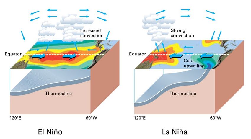
Typical circulation patterns during
El Niño/La Niña (Source: WMO,
El Niño/Southern Oscillation)
Climate Patterns in the Pacific
Research conducted over recent decades has shed considerable light on the important role played by
interactions between the atmosphere and ocean in the tropical belt of the Pacific Ocean in altering global
weather and climate patterns. During El Niño events, for example, sea temperatures at the surface in the
central and eastern tropical Pacific Ocean become substantially warmer than normal. In contrast, during La
Niña events, the sea surface temperatures in these regions become colder than normal. These
temperature changes are strongly linked to major climate fluctuations around the globe and, once initiated
such events can last for 12 months or more. The strong El Niño event of 1997–1998 was followed by a
prolonged La Niña phase that extended from mid-1998 to early 2001. El Niño/La Niña events change the
likelihood of particular climate patterns around the globe, but the outcomes of each event are never exactly
the same. Furthermore, while there is generally a relationship between the global impacts of an El Niño/La
Niña event and its intensity, there is always potential for an event to generate serious impacts in some
regions irrespective of its intensity.
Forecasting and Monitoring the El Niño/La Niña Phenomenon
The forecasting of Pacific Ocean developments is undertaken in a number of ways. Complex dynamical
models project the evolution of the tropical Pacific Ocean from its currently observed state. Statistical
forecast models can also capture some of the precursors of such developments. Expert analysis of the
current situation adds further value, especially in interpreting the implications of the evolving situation
below the ocean surface. All forecast methods try to incorporate the effects of ocean-atmosphere
interactions within the climate system.
The meteorological and oceanographic data that allow El Niño and La Niña episodes to be monitored and
forecast are drawn from national and international observing systems. The exchange and processing of the
data are carried out under programmes coordinated by the WMO.
WMO El Niño/La Niña Update
The WMO El Niño/La Niña Update is prepared on a quasi-regular basis (approximately every three months)
through a collaborative effort between WMO and the International Research Institute for Climate and
Society (IRI) as a contribution to the United Nations Inter-Agency Task Force on Natural Disaster Reduction.
It is based on contributions from the leading centres around the world monitoring and predicting this
phenomenon and expert consensus facilitated by WMO and IRI.For more information on the Update and related aspects, please visit: https://public.wmo.int/en/our-mandate/climate/el-niñola-niña-update
You can also read