FEMA Region 6 Weather Threat Briefing - Texas DPS

Page created by Kirk Barker
 
CONTINUE READING
FEMA Region 6 Weather Threat Briefing - Texas DPS
Prepared by
                                                                                                                  Nikki Hathaway

                      FEMA Region 6
                   Weather Threat Briefing
                                   Tuesday, September 25, 2018

Disclaimer: The purpose of this briefing is to provide a Regional weather threat assessment and is meant as a general overview.
 County/Parish decision makers should consult their local NWS forecast offices for the latest detailed, local weather information.
                              To find your local NWS forecast office, go to www.weather.gov/srh.

                                                                                                                               www.weather.gov/srh
FEMA Region 6 Weather Threat Briefing - Texas DPS
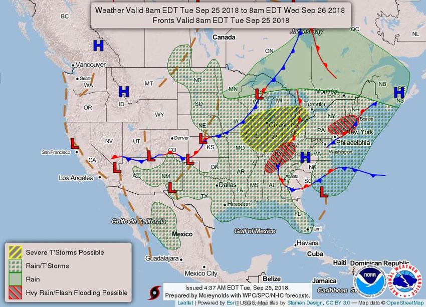
Summary of the Upcoming Week                                                             SR ROC
                                                                                         REGIONAL OPERATIONS CENTER

Today
     • River flooding will continue in TX and SE OK.
     • No other significant weather is expected.
Wednesday - Thursday
     • Isolated heavy rain possible, mostly in S TX.
     • River flooding will continue in TX and SE OK.
Friday - Saturday
     • Isolated heavy rain threat across S-Central TX and LA.

Tropical Outlook
     • The remnants of Kirk continue to move west at a speed of 25 mph. Its remnants have a 60% chance
       to redevelop as it moves westward toward the Caribbean, where conditions are highly unfavorable
       for further development. There are no impacts expected to Region VI.
     • Subtropical Storm Leslie is in the North Atlantic and will have no impact to Region VI.
     • A broad area of low pressure located about 260 miles south of Cape Hatteras, North Carolina,
       continues to produce showers and thunderstorms on its north side. Satellite and surface data
       indicate that the circulation of the low is elongated and not well organized. However, this system
       could still become a tropical depression later today while it moves northwestward.

9/25/2018 7:49 AM                                                                              www.weather.gov/srh
FEMA Region 6 Weather Threat Briefing - Texas DPS
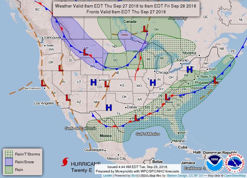
FEMA Region 6 Threat Matrix                                                                                               SR ROC
                                                                                                                          REGIONAL OPERATIONS CENTER
     Sept 25, 2018 – Sept 29, 2018

DAY / THREAT                        TUE                  WED                     THU                      FRI                       SAT

   Severe Storms

    Heavy Rain /
                                                           S TX                   S TX             Central/S TX into LA     Central/S TX into LA
   Flash Flooding

    Fire Weather

 Tropical Weather

   River Flooding             SE OK, N & S TX        SE OK, N & S TX         SE OK, N & S TX

      No Weather Threats Expected
      Very Common – Happens Often
      Common – Happens Frequently
                                                                  *Threat levels are based on FEMA Region 6 criteria.
      Uncommon – A Few Times a Year
                                                                     State or local threat level criteria may differ.*
      Rare – Once Every 1-5 Years
                                                For more details on the colors in the threat matrix refer to the last slide in this briefing.
      Very Rare – Once Every 5-10 Years

9/25/2018 7:49 AM                                                                                                               www.weather.gov/srh
FEMA Region 6 Weather Threat Briefing - Texas DPS
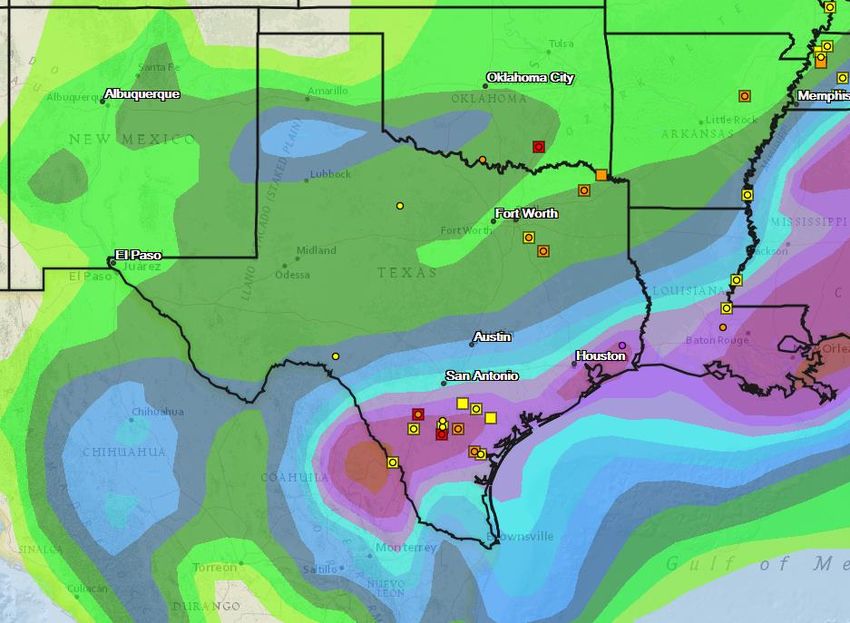
Tropical Weather Outlook – Atlantic/Gulf                                                                                               SR ROC
                                                                                                                                         REGIONAL OPERATIONS CENTER

                                                                                          See next slide for information on Subtropical
                                                                                                        Depression Leslie.
                                                                                             The remnants of Kirk are located about 950 miles east of the
                                                                                         Windward Islands and are moving quickly westward at around 25 mph.
                                                                                             This system continues to produce a large area of showers and
                                                                                           thunderstorms, along with winds to near gale force in gusts on its
                                                                                            north side. However, satellite data indicate that the system still
                                                                                          lacks a closed circulation. This disturbance could redevelop into a
                                                                                              tropical cyclone during the next day or two before it moves
                                                                                               into an area of highly unfavorable upper-level winds while it
                                                                                                             approaches the Caribbean Sea.
                                                                                            • Formation chance through 48 hours…medium…60 percent.
                                                                                              • Formation chance through 5 days…medium…60 percent.

   A broad area of low pressure located about 260 miles south of Cape Hatteras,
  North Carolina, continues to produce showers and thunderstorms on its north
side. Satellite and surface data indicate that the circulation of the low is elongated
    and not well organized. However, this system could still become a tropical
 depression later today while it moves northwestward. By tonight and Wednesday,
additional development appears unlikely, due to strong upper-level winds, while the
system moves northward and north-northeastward near the southeastern United
   States coast. Regardless of tropical cyclone formation, this system is likely to
bring scattered showers and thunderstorms across portions of northeastern South
            Carolina and eastern North Carolina later today and tonight.
              No significant impacts to FEMA IV are expected at this time!
          • Formation chance through 48 hours…medium…50 percent.
             • Formation chance through 5 days…medium…50 percent.

 9/25/2018 7:49 AM              See http://www.hurricanes.gov for the latest on the tropics or any active storms                               www.weather.gov/srh
FEMA Region 6 Weather Threat Briefing - Texas DPS
Subtropical Depression Leslie                                                                          SR ROC
                                                                                                       REGIONAL OPERATIONS CENTER

                                                                    Subtropical Depression Leslie is forecast
                                                                   to meander in the central Atlantic and will
                                                                      have no impact to FEMA Region VI.

9/25/2018 7:49 AM   See http://www.hurricanes.gov for the latest on the tropics or any active storms         www.weather.gov/srh
FEMA Region 6 Weather Threat Briefing - Texas DPS
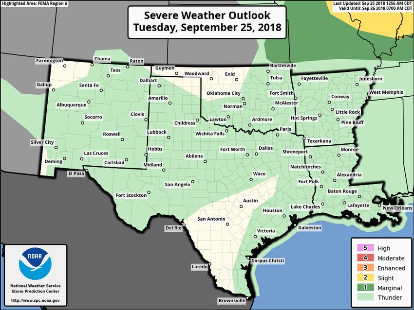
5-Day Precipitation Forecast & River Flood Status                                                                                                 SR ROC
                                                                                                                                                  REGIONAL OPERATIONS CENTER
       Note: Even though the image displays 5 days of forecasted rainfall, river forecasts only include 1-2 days of rainfall

                                                                                                                                 The Clear Boggy Creek above Caney
                                                                                                                                Creek near Caney in SE OK remains in
                                                                                                                                Moderate Flood Stage, but has crested
                                                                                                                               and should continue to fall to near Minor
                                                                                                                               Flood Stage near mid week. Agricultural
                                                                                                                               impacts are likely, along with rural roads
                                                                                                                                               impassable.
                                                                                                                               Ongoing flooding on the Nueces and high
                                                                                                                                 inflows into Lake Corpus. The Nueces
                                                                                                                                River near Tilden remains in Moderate
                                                                                                                                Flood Stage and is expected to lower to
                                                                                                                                Minor Flood Stage late Wednesday into
                                                                                                                                                Thursday.

9/25/2018 7:49 AM                         See http://water.weather.gov/ahps for the latest on river flooding                                            www.weather.gov/srh
FEMA Region 6 Weather Threat Briefing - Texas DPS
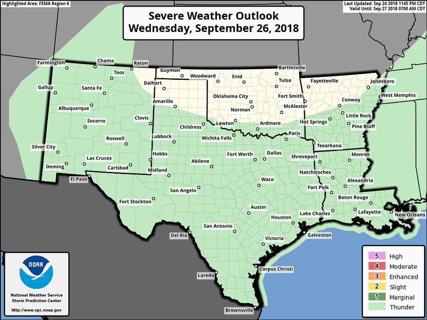
Today’s Weather                                                       SR ROC
                                                                      REGIONAL OPERATIONS CENTER
               Forecast Chart       Forecast Rainfall
                                                              River Flooding is ongoing
                                                             across portions of SE OK, N
                                                                       & S TX.

                                                              Otherwise, no significant
                                                                weather expected.

      Severe Weather Outlook    Excessive Rainfall Outlook

9/25/2018 7:49 AM                                                           www.weather.gov/srh
FEMA Region 6 Weather Threat Briefing - Texas DPS
Tomorrow’s Weather                                                   SR ROC
                                                                     REGIONAL OPERATIONS CENTER
             Forecast Chart       Forecast Rainfall
                                                            Isolated heavy rainfall could
                                                           lead to the potential for flash
                                                                flooding across S TX.

                                                            River Flooding is ongoing
                                                           across portions of SE OK, N
                                                                     & S TX.

    Severe Weather Outlook    Excessive Rainfall Outlook

9/25/2018 7:49 AM                                                          www.weather.gov/srh
FEMA Region 6 Weather Threat Briefing - Texas DPS
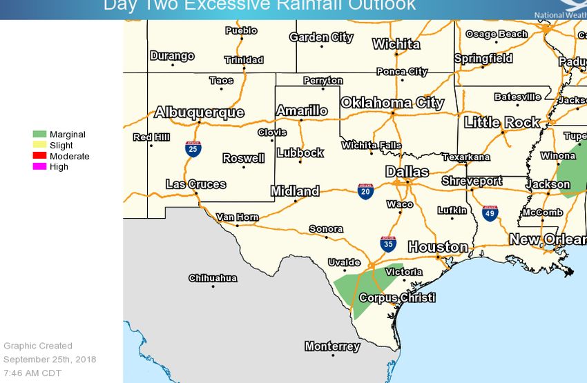
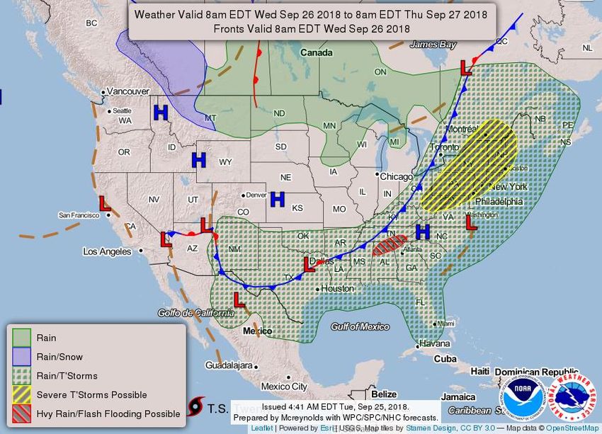
Thursday’s Weather                                                   SR ROC
                                                                     REGIONAL OPERATIONS CENTER
             Forecast Chart       Forecast Rainfall
                                                            Isolated heavy rainfall could
                                                           lead to the potential for flash
                                                                flooding across S TX.

                                                            River Flooding is ongoing
                                                           across portions of SE OK, N
                                                                     & S TX.

    Severe Weather Outlook    Excessive Rainfall Outlook

9/25/2018 7:49 AM                                                          www.weather.gov/srh
FEMA Region 6 Weather Threat Briefing - Texas DPS
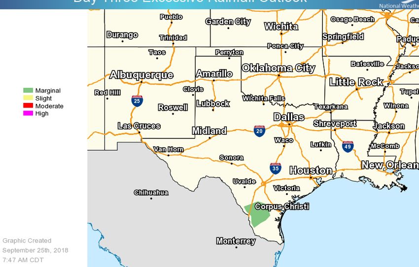
Days 4-5 Weather Hazards                                                               SR ROC
                                                                                       REGIONAL OPERATIONS CENTER
     Friday - Saturday

                                          Isolated heavy rain
                                          possible Friday into
                                               Saturday
      No Weather Threats Expected
      Very Common – Happens Often
      Common – Happens Frequently
                                                     *Threat levels are based on FEMA Region 6 criteria.
      Uncommon – A Few Times a Year
                                                        State or local threat level criteria may differ.*
      Rare – Once Every 1-5 Years                  For more details on the colors in the threat matrix refer to
      Very Rare – Once Every 5-10 Years                           the last slide in this briefing.

9/25/2018 7:49 AM                                                                            www.weather.gov/srh
Space Weather 3-Day Forecast                                                      SR ROC
                                                                                  REGIONAL OPERATIONS CENTER

                                     Tuesday                  Wednesday           Thursday
                                Quiet to Unsettled         Quiet to Unsettled       Quiet
     Geomagnetic Storms
                                  (Max Kp = 3)               (Max Kp = 3)        (Max Kp = 2)
Solar Radiation Storm (S1-S5)          1%                         1%                  1%

    Radio Blackout (R1-R2)             1%                         1%                  1%

    Radio Blackout (R3-R5)             1%                         1%                  1%

                                                         Click here for a
                                                     Description of the Space
                                                      Weather Storm Scales

                                                     Click here for the Latest
                                                      3-Day Space Weather
                                                           Forecast Text

9/25/2018 7:49 AM                                                                       www.weather.gov/srh
For more information, please contact:
                                              National Weather Service
                                             Southern Region Headquarters
                                              Regional Operations Center
                                                    Fort Worth, TX

                                             Phone: (682) 703-3747
                                          E-mail: sr-srh.roc@noaa.gov
                                         Web: http://www.weather.gov/srh
@NWS_Southern_US https://twitter.com/NWS_Southern_US                        https://www.facebook.com/NWSSouthern
Criteria for the
 color codes in
this briefing is
   to the left,
please provide
 any feedback
          to
sr-srh.roc@noaa.gov.
You can also read