Further Progress Report from the Independent Group, and Updated MH370 Search Area Recommendation
←
→
Page content transcription
If your browser does not render page correctly, please read the page content below
Further Progress Report from the Independent Group,
             and Updated MH370 Search Area Recommendation

Executive Summary
Continued analysis of the publicly-available information pertaining to the flight of MH370 has enabled us
to improve our estimate of where the aircraft crashed into the southern Indian Ocean. Our ‘most
probable’ end point is located at 37.71S 88.75E, slightly to the southwest of our previous solution, but
further to the south than any of the currently announced potential search areas. This minor adjustment
to our estimate of the terminal location of the aircraft resulted from the incorporation of all 497 satellite
communication propagation time delays, rather than the 17 used by the official investigation teams,
reducing the uncertainty in the location of the ‘7th arc’, which constrains possible positions of the
aircraft at about the time of fuel exhaustion [“about” because the final satellite communication pings
occurred after the time of exhaustion].
          In addition, we interpret the Doppler-shift information from analysis of the radio frequency
offsets of the final two ping signals as consistent with a near-vertical dive by the aircraft. This would
indicate a crash into the ocean very close to the 7th arc.
          Our analysis of the expected range and flight time endurance for cruise at normal altitudes and
speeds, taking account of the reported initial fuel load, take-off mass and non-standard atmospheric
temperatures, strongly supports our most-probable end point.
          Our investigation continues to be hampered by the lack of public release of the following
information, which we have previously requested through official channels: (a) a complete Inmarsat
data log; (b) information pertaining to the jitter characteristics of the onboard satellite communication
terminal, this jitter limiting our determination of the location of the 7th arc; (c) ADS-B and ACARS-
derived positions for the aircraft in the early part of its flight, and the remaining fuel at the top of the
initial climb; (d) PDA (Performance Degradation Allowance) information for the two engines installed on
the aircraft; (e) the CI (Cost Index) for flight operations used by Malaysia Airlines in the original flight
plan; and (f) Radar-derived positions of the aircraft known to exist for the period it was over the Malacca
Strait and north of Sumatra.

Introduction
Since our last report dated 9th September 2014 the Independent Group (IG) has addressed several
questions regarding specific details of our analyses. The following is a discussion of several aspects of
the work, which should be read in the context of our previous reports. We also add an investigation
directed towards understanding the fuel consumption of the aircraft and the limitations imposed by
available fuel, and we anticipate that this will be refined in the near future. We continue to analyse the
technical data that is openly available and have identified additional information which, if made public,
would materially aid our work and potentially lead to a further narrowing-down of the likely end point
of the aircraft’s flight.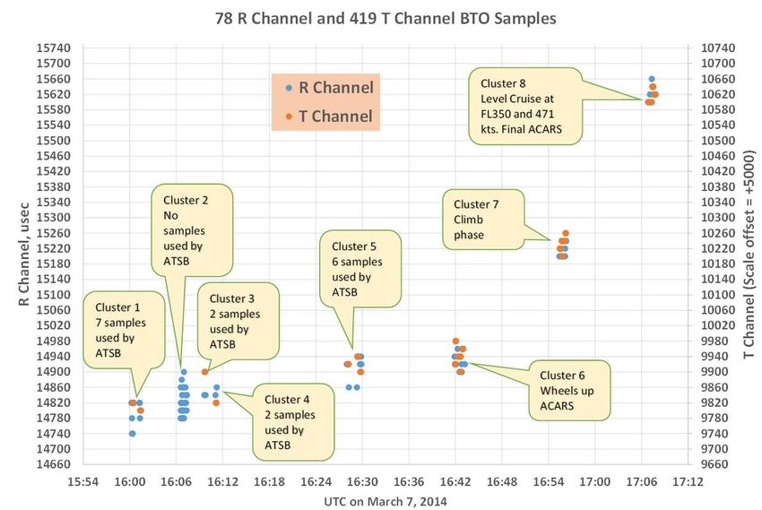
1. Burst Timing Offset (BTO) Analysis

1.1 BTO Analysis based on all 78 R–Channel and 419 T–Channel Values
Rather than relying, as has the Australian Transport Safety Bureau (ATSB), on only 17 R-channel values
between 16:00 and 16:30 for the calibration of the BTO bias and thus the equal-range arcs, the IG has
considered all of the R- and T-channel BTO data available (nearly 500 records) between 16:00 and 17:07.
(All times stated herein are in UTC.) The T-channel BTO data appear to be as valid as the R-channel BTO
data (with a 5,000 µsec offset between the two).
         We have verified the ADS-B (Automatic Dependent Surveillance-Broadcast) positions of the
aircraft for each of the BTO data points up to 17:07, and these positions appear to be acceptable for
calibrating the BTO bias. We have more confidence in the BTO measurements that were gathered after
MH370 left its departure gate, because there is less likelihood of radio signal multi-path errors due to
reflections from nearby objects, although there is still unexplained jitter from the AES (Aircraft Earth
Station: onboard satellite communication terminal). Using the data in clusters 5 through 8 in Figure 1
(below), we calculate BTO bias values of –495,648 and –495,663 µsec using two of our initial calibration
models, as follows:
            Cluster Number     Average BTO     Model #1          Model #2
                   5              14920        –495,600          –495,641
                   6              14940        –495,660          –495,650
                   7              15230        –495,648          –495,644
                   8              15615        –495,701          –495,656
                                  Averages:    –495,663 µsec     –495,648 µsec
A more extensive analysis of all 497 R- and T-channel values together with the Perth-Satellite-Aircraft
distances at each measurement time should be performed to calibrate the BTO bias against the known
‘ground truth’, ADS-B or ACARS (Aircraft Communications Addressing and Reporting System) locations of
the aircraft; but for us to do this analysis this we need access to the ACARS data, which has not yet been
publicly released in full machine-readable form.

1.2 BTO Analysis based on ACARS messages and MH370 Data Communications Logs
We note that Figure 19 in the ATSB report (26th June 2014; updated 13/15/18th August) shows the
17:07 BTO-derived arc as being 3 NM (nautical miles) west of the 17:07 ACARS position. This difference
is equivalent to a 26 µsec BTO bias error, consistent with the average of our two independent results
reported above (23.5 µsec difference from the ATSB report value).
         We request that the ATSB makes available the ACARS messages with respect to the aircraft’s
locations, altitudes, and speeds (rate-of-climb, delta-latitude, delta-longitude) prior to 17:07, as this
would provide more reliable data than the ADS-B information, enabling us to refine further our BTO
calibration and thus recommend more accurate constraints on the flight’s end point.
         The complete, un-redacted Inmarsat MH370 Data Communication Logs including all rows and all
fields would be necessary for our analysis with regard to accounting for frame position errors with
regard to both BTO and BFO (see below) values.

      Further Progress Report from the IG, and Updated MH370 Search Area Recommendation
      26th September 2014                                                                           2
Figure 1: BTO values available from both the R- and the T-channels. Only 17 R-channel values
were used in the analysis in the ATSB report, all of these pertaining to the time when the aircraft
was on the ground and thus the values were potentially susceptible to multi-path propagation
errors, leading to greater scatter in the measurements than later, when the aircraft was
airborne. Aircraft positions at these later times, derived from ADS-B and (if made available)
ACARS data, allow a refinement of the calibrations of the BTO values and therefore more-precise
positional arcs for the ‘unknown’ part of the flight (post-18:22).
2. Burst Frequency Offset (BFO) Analysis
2.1 MH370 End Point Analysis
Whilst the BTO data provide the distance of the aircraft from the satellite and constrain the possible
locations along the so-called ‘ping rings’ or arcs at each satellite handshake time, the BFO data constrain
the azimuth, ground speed and rate of climb/descent for a given location. Use of the BTO bias values
presented above together with the BFO information allows us to derive feasible flight paths with greater
confidence. Examples of such path computations were presented in our report of 9th September 2014.
The analysis is not straightforward because the AES used partially compensates for the effects of aircraft
motion relative to the satellite.
The BFO data are consistent with a conclusion that MH370 was flying in a southerly direction by
18:40. The BFO data also show a consistent near-linear relationship versus time from 18:40 until 00:11.
The end point(s) we derive have shifted a little further south along the 7th arc than our previous cluster
of solutions due to our BTO re-calibration, resulting in the derived end point near 37.71S 88.75E.
Further Progress Report from the IG, and Updated MH370 Search Area Recommendation
26th September 2014 3The BFO errors that are computed for other more-northerly flight paths that also end on the 7th
arc (cf. ATSB report) are much higher in comparison with those derived for our direct southerly route
(speed, altitude and path along a geodesic consistent with a ‘normal’ high-altitude cruise), and scenarios
employing arbitrary speeds and unexplained azimuth changes lack plausibility, and therefore are
deemed much less likely by the IG.
(By “BFO errors” here we mean the deviations between the measured BFO values and the
values computed on the basis of hypothesized flight paths; our indicated end points for the flight are
based on minimising both the BTO and the BFO “errors”, thus achieving a best-fit to the BTO and BFO
information.)
To summarise the implications of the above: We argue that these results indicate that the
underwater search teams should be strongly advised to begin their hunt in the vicinity of our ‘most
probable’ end point: 37.71S 88.75E.
2.2 MH370 End-of-Flight Analysis
The behaviour of the aircraft after fuel exhaustion has relevance to the width of the planned search area
parallel to the 7th arc. The end location exhibits most uncertainty along the arc rather than
perpendicular to it. By examining end-of-flight scenarios we conclude that it may be feasible to reduce
the uncertainty in the possible locations of the end point in the directions transverse to the arc, thus
reducing the width of the band to be searched initially, allowing (for a given areal budget) a longer
section of the arc to be scoured should the aircraft’s crash location not be found quickly.
A spiral dive would not be unexpected as the result of circumstances whereby first one engine
cuts out at fuel expiration, and shortly thereafter (perhaps several minutes) the second engine also cuts
out. It is quite possible that a phugoid mode developed before the aircraft rolled off into a spiral
dive. The stability immediately after the second engine cut out will be dependent on whether the
TAC (Thrust Asymmetry Compensation) was deflected to the right or to the left. Right deflection may
cause an earlier entry into the final spiral because the Ram Air Turbine (RAT) drag will promote a turn in
that direction. Alternatively, deflection to the left may delay the entry into the final spiral for a short
period.
This question (right versus left deflection, and therefore the time delay until the final spiral dive
is entered) might be addressed by knowing which engine was first to use all its fuel, and that might be
identified using the Performance Degradation Allowance (PDA) numbers for each engine. These are
known to the operators (i.e. Malaysia Airlines), but we have not been granted access to that
information. Knowing the PDA numbers would also assist our calculations of the fuel-range limit (as
discussed in section 3 below).
2.3 Rate of Descent Implied by the final BFO values
The BFO data are compensated during the flight for the horizontal speed of the aircraft, but not for rate-
of-climb, which may of course be negative (i.e. a descent). BFO values are therefore sensitive to the
altitude being rapidly-changing, potentially enabling the calculation of the rate of descent of the aircraft
in a final dive.
Further Progress Report from the IG, and Updated MH370 Search Area Recommendation
26th September 2014 4Although questions may remain as to the interpretation of the BFO values at 00:19:29 and
00:19:37 (182 Hz and then –2 Hz, compared to the steady, linear increase to 252 Hz at 00:11:00), there is
no reason to reject the recorded values outright. The BFO values cannot be explained by an onboard
AES-compensated horizontal speed in any direction. The fact that there were no more records logged
after 00:19:37 we interpret as being due to the aircraft having crashed very soon thereafter, consistent
with the final two BFO values representing a rapid downward trajectory.
The rate-of-descent we calculate from the final BFO value is approximately 15,700 feet per
minute. This is an almost vertical dive at 287 km per hour (155 knots). The descent rate was very
likely increasing rapidly (i.e. accelerating under gravity, only limited by the aircraft drag).
The occurrence of a near-vertical spiral dive has significant implications in reducing the width of
the target search area, as mentioned previously. We argue that the aircraft could not have flown far
beyond the 7th arc before crashing into the ocean, if it went beyond that arc at all: the BFO data at that
time (00:19:29 and 00:19:37) indicate that MH370 was in a tight spiral dive (radius below 1 NM) over
the 7th arc and therefore the crash may actually have been just inside that arc.
3. Fuel Exhaustion Considerations
Using performance data for the Long Range Cruise (LRC) Mach mode it was possible to perform both
analytical and numerical integrations to determine an expected endurance and range for cruise at FL350
(i.e. nominally 35,000 feet). The analysis takes account of the reported take-off mass and fuel load,
together with the non-standard atmospheric temperatures for the region in question obtained from a
GDAS/NOAA (Global Data Assimilation System/National Atmospheric and Oceanic Administration)
reanalysis.
The ATSB report (page 33) specifies an anticipated fuel exhaustion time close to 00:16. We find
from our fuel analysis for optimal conditions a time of fuel exhaustion occurring about ten minutes later.
By incorporating a small performance degradation, having the effect of increasing the fuel flow rate by 3
per cent, it is possible to reconcile our calculated time of fuel exhaustion with the time estimated in the
ATSB report. The range predicted by this fuel analysis, again taking account of the same small
performance degradation, is within 1 to 2 per cent of the total cruise trip distance to our most-probable
end point, which is based on the BTO and BFO values alone (cf. sections 1 and 2 above, plus our previous
progress reports).
A number of sources of uncertainty affect the intersection between the final BTO-derived ring
(the 7th arc) and the Fuel Exhaustion Curve (FEC) (e.g. Figure 1 in our preceding report; note that this
implies that we lack confidence in the brown curve shown in that diagram, which was derived from the
ATSB report). These uncertainties include the position of that final arc itself, due to the BTO bias value
and statistical uncertainties, but in addition we mention the following considerations:
a) Uncertainty in the headwind component (the GDAS/NOAA reanalysis indicates a time-averaged
headwind component of 2 knots);
b) Uncertainty in the temperature field (the cruise range is decreased by about 4 NM for each 1
degree Celsius increase in temperature deviation);
Further Progress Report from the IG, and Updated MH370 Search Area Recommendation
26th September 2014 5c) Uncertainty in the position of the fuel-range ring origin (i.e. when and where the aircraft made
its final turn southwards);
d) Uncertainty in the engines’ performance degradation parameters (the cruise range is decreased
by about 36 NM for each 1 per cent increase in fuel flow);
e) Uncertainty as to which speed mode was used; our analysis assumes LRC.
In terms of fuel exhaustion analysis the remaining fuel on board at the end-of-climb, which would have
been given in the ACARS messages prior to 17:07, would be another useful parameter which we would
like to see made public.
4. Radar Detections of MH370
Whilst our method for determining the southwards path of MH370 enables a direct calculation of the
ground speed, a useful check on that would be the ground speed of the aircraft whilst it was flying over
the Malacca Strait and the sea to the north of Sumatra. Coupled with the known winds, that ground
speed would render a True Air Speed (TAS) which could then be compared to our derived speed for the
long southward leg to its eventual end point.
We have calculated the westerly TAS north of Sumatra and find it to be in agreement with our
derived speed for that final leg of the flight. However, our only source of information for that calculation
is a map of radar-determined positions of MH370 through to 18:22 projected onto a screen at a briefing
held on 21st March 2014 for relatives of Chinese passengers at the Lido Hotel in Beijing by a delegation
led by Lt. Gen. Ackbal bin Haji Abdul Samad, Air Operations Commander of the Royal Malaysian Air
Force. This was recorded by Kim Kyung Hoon of Reuters and other photographers. These images are
photographs of slides of photographs of a radar playback screen and are obviously sub-optimal data
sources.
We request that these radar-derived positions of the aircraft, which we believe were measured
by Thai military surveillance systems, be publicly released. These would enable us to improve our
knowledge of the aircraft speed before it turned south, which might be expected to be the same as on
the final southern leg if we assume that the aircraft was under automated control. These radar positions
and the derived speed would also facilitate: (a) Estimation of fuel usage during that stage of the flight;
and (b) Estimation of the time at which the aircraft turned south, which presently we only know to have
been between 18:28 and 18:40.
5. Summary
Our analysis of the limitations imposed by fuel consumption versus load considerations is ongoing, and
our intent is to provide an update on the Fuel Exhaustion Curve at a later time, along with refinements
in our BTO calibration. We note that all aspects of our analysis, and therefore our capability to narrow
down the crash location of the aircraft, would be significantly aided by the public release of a number of
pieces of information that are currently being withheld.
Further Progress Report from the IG, and Updated MH370 Search Area Recommendation
26th September 2014 6For clarity we note the following regarding (1) BTO, (2) BFO and (3) Fuel uncertainties:
1. The uncertainty in the BTO values is the smallest of those three, enabling a non-circular 7th arc
across the ocean to be drawn with some precision (perhaps 10 NM radially), but subject to
improvement if the ACARS data were made available to us. The uncertainties in the BTO values
might also be reduced if we understood the apparent jitter in the measurements that are
apparent even after the aircraft became airborne: this requires information to be released by
the suppliers of the signalling units, Square Peg Communications, although other AES
components might also contribute to the jitter. We note, however, that the BTO values do not in
themselves provide an evaluation of the azimuth of the point at which MH370 crossed that arc.
2. The uncertainty in the BFO values is the next-smallest, and in combination with the BTO values
enables the computation of both a path and a (slightly-varying) speed of the aircraft and thus
the azimuthal position of the end point on the 7th arc (uncertain by perhaps 100 NM along the
arc). In addition, the final two BFO values are consistent with a near-vertical dive by the aircraft
above the 7th arc and therefore a crash into the ocean close to that arc (rather than a glide
beyond the arc). Our analysis of the BFO values and their implications would be aided by the
release of the full Inmarsat data log, including those lines near 16:00 which were missing from
the release on 27th May 2014.
3. The uncertainty in the fuel consumption rates (or, the uncertainty in the point at which fuel
exhaustion occurred) is the largest of these three, but our analysis based on the known fuel load
is consistent with our calculated end point of the aircraft based on the BTO and BFO values. Our
analysis of the constraints that fuel consumption considerations can impose would be aided by
the public release of the PDA (Performance Degradation Allowance) values for each of the
engines, and also the Cost Index parameters as normally used by the airline; plus the fuel
remaining at the top-of-climb, as delivered by the ACARS messages.
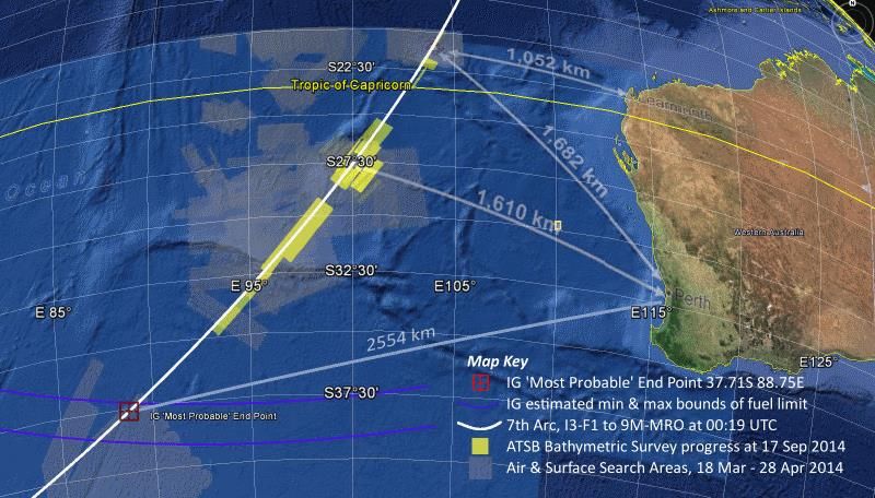
In conclusion, the IG end point analysis fits with the IG fuel analysis, taking account of the uncertainties
mentioned above. This gives us additional confidence that our derived end point at 37.71S 88.75E
(Figure 2) is close to the impact location of MH370, and we urge that the underwater search be directed
towards this region.
Further Progress Report from the IG, and Updated MH370 Search Area Recommendation
26th September 2014 7Figure 2: Intersection of the 7th arc and the fuel exhaustion range (based on Long Range
Cruise at FL350), showing our ‘most probable’ end point for the flight.
6. Independent Group
The following individuals have agreed to be publicly identified with this statement, to represent the
larger collective that has contributed to this work, and to make themselves available to assist with the
investigation in any constructive way. Others prefer to remain anonymous, but their contributions are
gratefully acknowledged.
Brian Anderson, BE: Havelock North, New Zealand
Sid Bennett, MEE: Chicago, Illinois, USA
Curon Davies, MA: Swansea, UK
Michael Exner, MEE: Colorado, USA
Tim Farrar, PhD: Menlo Park, California, USA
Richard Godfrey, BSc: Frankfurt, Germany
Bill Holland, BSEE: Cary, North Carolina, USA
Geoff Hyman, MSc: London, UK
Victor Iannello, ScD: Roanoke, Virginia, USA
Barry Martin, CPL: London, UK
Duncan Steel, PhD: Wellington, New Zealand
Don Thompson: Belfast, Northern Ireland
Jeffrey James Wise, BS: New York, NY, USA
Further Progress Report from the IG, and Updated MH370 Search Area Recommendation
26th September 2014 8You can also read